Ontario's Natural Heritage Areas - Ministry of Natural Resources
Ontario's Natural Heritage Areas - Ministry of Natural Resources
Ontario's Natural Heritage Areas - Ministry of Natural Resources

Create successful ePaper yourself
Turn your PDF publications into a flip-book with our unique Google optimized e-Paper software.
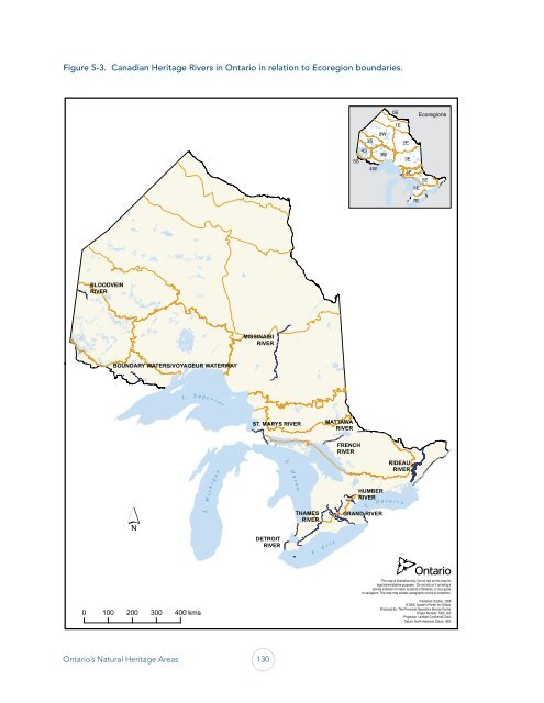
Figure 5-3. Canadian <strong>Heritage</strong> Rivers in Ontario in relation to Ecoregion boundaries.<br />
BLOODVEIN<br />
RIVER<br />
BOUNDARY WATERS/VOYAGEUR WATERWAY<br />
0 100 200 300 400 kms<br />
L . S u p e r i o r<br />
L . M i c h i g a n<br />
MISSINAIBI<br />
RIVER<br />
Ontario’s <strong>Natural</strong> <strong>Heritage</strong> <strong>Areas</strong> 130<br />
ST. MARYS RIVER<br />
DETROIT<br />
RIVER<br />
L . H u r o n<br />
THAMES<br />
RIVER<br />
L . E r i e<br />
MATTAWA<br />
RIVER<br />
5S<br />
FRENCH<br />
RIVER<br />
4S<br />
3S<br />
4W<br />
HUMBER<br />
RIVER<br />
GRAND RIVER<br />
2W<br />
3W<br />
0E<br />
1E<br />
RIDEAU<br />
RIVER<br />
L . O n t a r i o<br />
2E<br />
3E<br />
4E<br />
6E<br />
7E<br />
Ecoregions<br />
5E<br />
This map is illustrative only. Do not rely on this map for<br />
legal administrative purposes. Do not rely on it as being a<br />
precise indicator <strong>of</strong> routes, locations <strong>of</strong> features, or as a guide<br />
to navigation. This map may contain cartographic errors or omissions.<br />
Published October, 2008<br />
© 2008, Queen's Printer for Ontario<br />
Produced By: The Provincial Geomatics Service Centre<br />
Project Number: 7400_023<br />
Projection: Lambert Conformal Conic<br />
Datum: North American Datum 1983