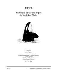
Washington's 2010 Big Game Hunting Seasons & Regulations
Washington's 2010 Big Game Hunting Seasons & Regulations
Washington's 2010 Big Game Hunting Seasons & Regulations

You also want an ePaper? Increase the reach of your titles
YUMPU automatically turns print PDFs into web optimized ePapers that Google loves.
to SR 4; E on SR 4 to Germany Creek Rd; N on<br />
Germany Creek Rd to International Paper 1000 line;<br />
N on International Paper 1000 line to International<br />
Paper 1050 line; E on International Paper 1050 line to<br />
International Paper 2200 line; E and S on International<br />
Paper 2200 to Woodside Dr; NE on Woodside Dr to<br />
Delameter Rd; E on Delameter Rd to the three power<br />
lines; N along the three power lines to Weyerhaeuser<br />
9312 line; E on Weyerhaeuser 9312 line to Growlers<br />
Gulch Rd; E on Growlers Gulch Rd to Public Highway<br />
10 Rd; E along the Public Highway 10 Rd to the A Street<br />
bridge over the Cowlitz River at the town of Castle<br />
Rock; S down the Cowlitz River to the Columbia River<br />
and point of beginning.<br />
GMU 505-MOSSYROCK (Lewis Co):<br />
Beginning on I-5 and the Cowlitz River; NE up the<br />
Cowlitz River to the Mayfield Dam; NE along the south<br />
shore of Mayfield Lake to the US Hwy 12 bridge; NE<br />
on US Hwy 12 to Winston Creek Rd; SE on Winston<br />
Creek Rd to Longbell Rd; E on Longbell Rd to Perkins<br />
Rd; NE on Perkins Rd to Green Mountain Rd; E on<br />
Green Mountain Rd to the outlet of Swofford Pond; E<br />
along the Swofford Pond outlet to Riffe Lake; E along<br />
the south shore of Riffe Lake to the Cowlitz River; up<br />
the Cowlitz River to the Rainier Timber 100 Mainline; N<br />
on the Rainier Timber 100 Mainline to US Hwy 12; W on<br />
US Hwy 12 to Davis Lake Rd; N and W on Davis Lake<br />
Rd to Main St at town of Morton; W on Main St to SR<br />
508; W on Highway 508 to Centralia-Alpha Rd; W and N<br />
on Centralia-Alpha Rd to Salzer Valley Rd; W on Salzer<br />
Valley Rd to Summa St at the town of Centralia; W on<br />
Summa St to Kresky Rd; N on Kresky Rd to Tower St; N<br />
on Tower St to SR 507; W on SR 507 (Cherry St, Alder<br />
St, and Mellen St) to I-5; S on I-5 to the Cowlitz River<br />
and point of beginning.<br />
GMU 506-WILLAPA HILLS (Wahkiakum, Pacific &<br />
Lewis cos.):<br />
Beginning at SR 6 and 3rd St South at the town of Pe<br />
Ell; S on 3rd St South to Muller Rd; S on Muller Rd to<br />
Weyerhaeuser 1000 line; S on Weyerhaeuser 1000 line<br />
to Weyerhaeuser 1800 line; S on Weyerhaeuser 1800<br />
line to Weyerhaeuser 500 line; SE on Weyerhaeuser<br />
500 line to SR 407 (Elochoman Valley Rd) at Camp 2;<br />
S on SR 407 (Elochoman Valley Rd) to the Elochoman<br />
River; down the Elochoman River to Foster Rd; N<br />
on Foster Rd to Risk Rd; W and N along Risk Rd to<br />
SR 4; W on SR 4 to Skamokawa Creek; SW down<br />
Skamokawa Creek to the Columbia River; W along<br />
Columbia River to the mouth of the Deep River<br />
(including all islands in the Columbia River which are<br />
both north of the Washington state line and between<br />
Skamokawa Creek and Deep River); N along the Deep<br />
River to SR 4; NW on SR 4 to the Salmon Creek Rd;<br />
NE on Salmon Creek Rd to Weyerhaeuser 5000 line; N<br />
on Weyerhaeuser 5000 line to Weyerhaeuser 5800 line;<br />
NE on Weyerhaeuser 5800 line to power transmission<br />
line; (Section 21, T11N, R8W); E, NE, and then N on the<br />
power transmission line to the Trap Creek A Line; E and<br />
N on the Trap Creek A Line to SR 6; E on SR 6 to the<br />
town of Pe Ell and the point of beginning.<br />
GMU 510-STORMKING (Lewis Co):<br />
Beginning on US Hwy 12 at the Silver Creek bridge; N<br />
up Silver Creek to Silverbrook Rd; E on Silverbrook Rd<br />
to US Forest Service Rd 47; N on US Forest Service Rd<br />
47 to US Forest Service Rd 85; W and N on US Forest<br />
Service Rd 85 to US Forest Service Rd 52; N on US<br />
Forest Service Rd 52 to the Nisqually River; W down<br />
the Nisqually River to SR 7; S on Hwy 7 to Main St at<br />
town of Morton; E on Main St to Davis Lake Rd; E on<br />
Davis Lake Rd to US Hwy 12; E on US Hwy 12 to the<br />
Silver Creek bridge and point of beginning.<br />
Area Descriptions<br />
GMU 513-SOUTH RAINIER (Lewis Co):<br />
Beginning on US Hwy 12 at the Silver Creek bridge; N<br />
up Silver Creek to Silverbrook Rd; E on Silverdale Rd<br />
to US Forest Service Rd 47; N on US Forest Service Rd<br />
47 to US Forest Service Rd 85; W and N on US Forest<br />
Service Rd 85 to US Forest Service Rd 52; W and N on<br />
US Forest Service Rd 52 to the Nisqually River; E up<br />
the Nisqually River to the southern boundary of Mount<br />
Rainier National Park; E along the south park boundary<br />
to the Pacific Crest Trail (US Forest Service Trail 2000);<br />
S along the Pacific Crest Trail (US Forest Service Trail<br />
2000) to US Hwy 12; W on US Hwy 12 to the Silver<br />
Creek bridge and point of beginning.<br />
GMU 516-PACKWOOD (Lewis & Skamania cos.):<br />
Beginning at US Hwy 12 and Pacific Crest Trail at White<br />
Pass; S on Pacific Crest Trail (US Forest Service Trail<br />
2000) to US Forest Service Trail 98 at Sheep Lake; W<br />
on US Forest Service Trail 98 to US Forest Service Rd<br />
2160 at Walupt Lake; W on US Forest Service Rd 2160<br />
to US Forest Service Rd 21; S and W on US Forest<br />
Service Rd 21 to US Forest Service Rd 23; S on US<br />
Forest Service Rd 23 to US Forest Service Trail 263;<br />
S and W on US Forest Service Trail 263 to US Forest<br />
Service Trail 261; S on US Forest Service Trail 261<br />
to US Forest Service Trail 1; W on US Forest Service<br />
Trail 1 to US Forest Service Rd 99; W on US Forest<br />
Service Rd 99 to US Forest Service Rd 26; N on US<br />
Forest Service Rd 26 to US Forest Service Rd 2612;<br />
W on US Forest Service Rd 2612 to US Forest Service<br />
Trail 217; N and W on US Forest Service Trail 217 to<br />
Weyerhaeuser 2600 line; Weyerhaeuser 2600 line to<br />
Weyerhaeuser 2658 line; N on Weyerhaeuser 2658<br />
line to Rainier Timber (Campbell Group) 430 line; N on<br />
Rainier Timber 430 line to the Rainier Timber Mainline<br />
400 line; N and E on Rainier Timber Mainline 400 line<br />
to Rainier Timber 300 line; E on Rainier Timber 300 line<br />
to Rainier Timber 271 line; N on Rainier Timber 271 line<br />
to the Cispus River; E on the Cispus River to US Forest<br />
Service Rd 25; N on US Forest Service Rd 25 to SR<br />
131; N on SR 131 to US Hwy 12; E on US Hwy 12 to<br />
the Pacific Crest Trail (US Forest Service Trail 2000) at<br />
White Pass and beginning.<br />
GMU 520-WINSTON (Cowlitz, Lewis, & Skamania<br />
cos.):<br />
Beginning at the bridge at intersection of I-5 and the<br />
Cowlitz River; S down the Cowlitz River to the Toutle<br />
River; E up the Toutle River to the South Fork Toutle<br />
River; SE up South Fork Toutle River to Johnson Creek;<br />
NE up Johnson Creek to Weyerhaeuser 4400 line; N<br />
along Weyerhaeuser 4400 line to Weyerhaeuser 2421<br />
line; N along Weyerhaeuser 2421 line to Weyerhaeuser<br />
2400 line; NW along Weyerhaeuser 2400 line to Alder<br />
Creek; NW down Alder Creek to North Fork Toutle River;<br />
W down the North Fork Toutle River to the Green River;<br />
E up the Green River to US Forest Service Rd 2612;<br />
E on US Forest Service Rd 2612 to US Forest Service<br />
Trail 217; N and W on US Forest Service Trail 217 to<br />
Weyerhaeuser 2600 line; W on Weyerhaeuser 2600<br />
line to Weyerhaeuser 2658 line; N on Weyerhaeuser<br />
2658 line to Rainier Timber (Campbell Group) 430 line;<br />
N on Rainier Timber 430 line to Rainier Timber 400<br />
Mainline; N and E on Rainier Timber 400 Mainline to<br />
Rainier Timber 100 Mainline; N on Rainier Timber 100<br />
Mainline to Cowlitz River; W down the Cowlitz River to<br />
Riffe Lake; W along the south shore to the Swofford<br />
Pond outlet; W along the Swofford Pond outlet to Green<br />
Mountain Rd; W on Green Mountain Rd to Perkins Rd;<br />
SW on Perkins Rd to Longbell Rd; W on Longbell Rd<br />
to Winston Creek Rd; NW on Winston Creek Rd to US<br />
Hwy 12; SW on US Hwy 12 to the Mayfield Lake bridge<br />
at Mayfield Lake; SW down the south shore of Mayfield<br />
Lake to the Cowlitz River at Mayfield Dam; SW down<br />
the Cowlitz River to I-5 bridge crossing the Cowlitz River<br />
and point of beginning.<br />
GMU 522-LOO-WIT (Cowlitz & Skamania cos.):<br />
Beginning on the North Fork Toutle River at the mouth<br />
of Hoffstadt Creek; SE up the North Fork Toutle River<br />
to Deer Creek; SE up Deer Creek to Weyerhaeuser<br />
3020 line; NW along Weyerhaeuser 3020 line to<br />
Weyerhaeuser 3000 line; E along Weyerhaeuser 3000<br />
line to US Forest Service Trail 216G; SE along US<br />
Forest Service Trail 216G to the intersection of US<br />
Forest Service Trail 238 and US Forest Service Trail<br />
216; S on US Forest Service Trail 238 to South Fork<br />
of the Toutle River; E along South Fork Toutle River to<br />
its headwaters and Mount St. Helens crater’s edge; E<br />
along the Mount St. Helens crater’s southern edge to<br />
the headwaters of Ape Canyon Creek; NE down Ape<br />
Canyon Creek to US Forest Service Trail 225 (Smith<br />
Creek Trail); N and NW on US Forest Service Trail 225<br />
(Smith Creek Trail) to US Forest Service Rd 99; NE<br />
along US Forest Service Rd 99 to US Forest Service Rd<br />
26; N on US Forest Service Rd 26 to US Forest Service<br />
Trail 1; W on US Forest Service Trail 1 to US Forest<br />
Service Trail 214; NW on US Forest Service Trail 214<br />
to US Forest Service Trail 211; W on US Forest Service<br />
Trail 211 to Coldwater Creek; W down Coldwater Creek<br />
to Coldwater Lake; SW along the northwest shore of<br />
Coldwater Lake to the outlet of Coldwater Lake; SW<br />
down the outlet stream from Coldwater Lake to SR 504<br />
bridge at mile post 45; W on SR 504 to Hoffstadt Creek<br />
Bridge on Hoffstadt Creek; S and W down Hoffstadt<br />
Creek to the North Fork Toutle River and point of<br />
beginning.<br />
GMU 524-MARGARET (Cowlitz, Skamania, & Lewis<br />
cos.):<br />
Beginning on the North Fork Toutle River at the mouth<br />
of the Green River; SE up the North Fork Toutle River<br />
to the mouth of Hoffstadt Creek; N and E up Hoffstadt<br />
Creek to the SR 504 bridge over Hoffstadt Creek; E on<br />
SR 504 to the bridge over the outlet to Coldwater Lake<br />
at mile post 45; NE up the outlet stream of Coldwater<br />
Lake to Coldwater Lake; NE along the northwest shoreline<br />
of Coldwater Lake to Coldwater Creek inlet; E up<br />
Coldwater Creek to US Forest Service Trail 211; NE on<br />
US Forest Service Trail 211 to US Forest Service Trail<br />
214; SE on US Forest Service Trail 214 to US Forest<br />
Service Trail 1; E on US Forest Service Trail 1 to US<br />
Forest Service Rd 26; N on the US Forest Service Rd<br />
26 (Ryan Lake Rd) to US Forest Service Rd 2612; W<br />
on US Forest Service Rd 2612 to the Green River; W<br />
down the Green River to its mouth on the North Fork of<br />
the Toutle River and point of beginning.<br />
GMU 530-RYDERWOOD (Cowlitz, Lewis &<br />
Wahkiakum cos.):<br />
Beginning at Stevens Rd and SR 6, south of the town of<br />
Doty; E on SR 6 to I-5 at the town of Chehalis; S on I-5<br />
to the Cowlitz River; S along the Cowlitz River to Public<br />
Hwy 10 on the A Street bridge at the town of Castle<br />
Rock; W on the Public Hwy 10 to Growler’s Gulch Rd;<br />
W on Growler’s Gulch Rd to Weyerhaeuser 9312 line;<br />
W on Weyerhaeuser 9312 line to three power lines;<br />
S on the three power lines to Delameter Rd; SW on<br />
Delameter Rd to Woodside Dr; SW on Woodside Dr to<br />
International Paper Rd 2200; N and W on International<br />
Paper Rd 2200 to International Paper Rd 1050; W on<br />
International Paper Rd 1050 to International Paper<br />
Rd 1000; S on International Paper Rd 1000 to the<br />
Germany Creek Rd; S on the Germany Creek Rd to<br />
SR 4; W on SR 4 to Germany Creek; S along Germany<br />
Creek to its mouth at the Columbia River; W along the<br />
Columbia River to Skamokawa Creek (including all<br />
islands in the Columbia River which are both north of<br />
the Washington state line and between Skamokawa<br />
Creek and Germany Creek); NE up Skamokawa Creek<br />
106<br />
Report your hunting activity for <strong>Big</strong> <strong>Game</strong> & Turkey by calling toll free 1-877-945-3492 or online at fishhunt.dfw.wa.gov.