

Vegetation Classification and Mapping Project Report - USGS
Vegetation Classification and Mapping Project Report - USGS
Vegetation Classification and Mapping Project Report - USGS

Create successful ePaper yourself
Turn your PDF publications into a flip-book with our unique Google optimized e-Paper software.
National Park Service<br />
U.S. Department of the Interior<br />
Natural Resource Program Center<br />
Buck Isl<strong>and</strong> Reef National Monument, U.S. Virgin Isl<strong>and</strong>s<br />
<strong>Vegetation</strong> <strong>Mapping</strong> <strong>Project</strong>, 2009<br />
Natural Resource Technical <strong>Report</strong> NPS/SFCN/NRTR—2010/293
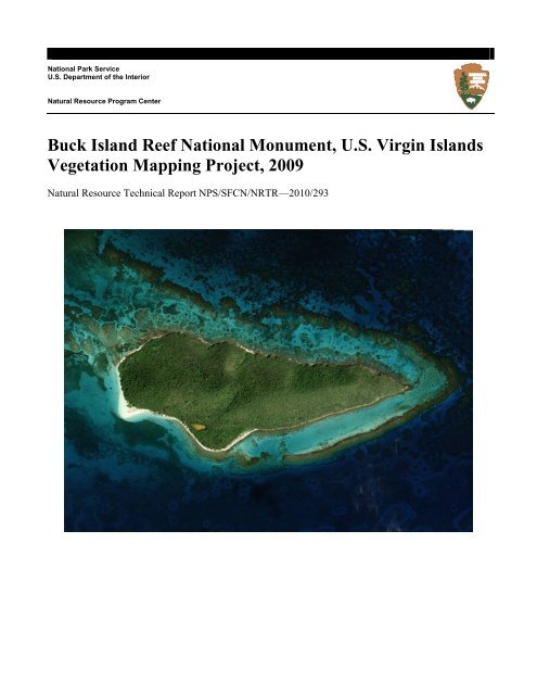
ON THE COVER<br />
2007 U.S. Army Corps of Engineers 30cm resolution orthoimage of Buck Isl<strong>and</strong> within Buck Isl<strong>and</strong> Reef National Monument.
______________________________________________<br />
Buck Isl<strong>and</strong> Reef National Monument, U.S. Virgin<br />
Isl<strong>and</strong>s, <strong>Vegetation</strong> <strong>Mapping</strong> <strong>Project</strong>, 2009<br />
Natural Resource Technical <strong>Report</strong> NPS/SFCN/NRTR—2010/293<br />
Jonathan G. Moser 1,2<br />
Resource Management Intern<br />
Kevin R. T. Whelan, Ph.D. 2<br />
Community Ecologist<br />
Robert B. Shamblin 2<br />
Botanist<br />
Andrea J. Atkinson, Ph.D. 2<br />
Quantitative Ecologist<br />
Judd M. Patterson 2<br />
GIS Specialist<br />
1 Florida International University<br />
Southeast Environmental Research Center<br />
University Park Campus<br />
Miami, FL 33199<br />
2 National Park Service<br />
South Florida / Caribbean Network<br />
18001 Old Cutler Rd., Suite 419<br />
Village of Palmetto Bay, FL 33157<br />
February 2010<br />
U.S. Department of the Interior<br />
National Park Service<br />
Natural Resource Program Center<br />
Fort Collins, Colorado
The National Park Service, Natural Resource Program Center publishes a range of reports that<br />
address natural resource topics of interest <strong>and</strong> applicability to a broad audience in the National<br />
Park Service <strong>and</strong> others in natural resource management, including scientists, conservation <strong>and</strong><br />
environmental constituencies, <strong>and</strong> the public.<br />
The Natural Resource Technical <strong>Report</strong> Series is used to disseminate results of scientific studies<br />
in the physical, biological, <strong>and</strong> social sciences for both the advancement of science <strong>and</strong> the<br />
achievement of the National Park Service mission. The series provides contributors with a forum<br />
for displaying comprehensive data that are often deleted from journals because of page<br />
limitations.<br />
All manuscripts in the series receive the appropriate level of peer review to ensure that the<br />
information is scientifically credible, technically accurate, appropriately written for the intended<br />
audience, <strong>and</strong> designed <strong>and</strong> published in a professional manner. This report received formal peer<br />
review by subject-matter experts who were not directly involved in the collection, analysis, or<br />
reporting of the data, <strong>and</strong> whose background <strong>and</strong> expertise put them on par technically <strong>and</strong><br />
scientifically with the authors of the information.<br />
Views, statements, findings, conclusions, recommendations, <strong>and</strong> data in this report are those of<br />
the author(s) <strong>and</strong> do not necessarily reflect views <strong>and</strong> policies of the National Park Service, U.S.<br />
Department of the Interior. Mention of trade names or commercial products does not constitute<br />
endorsement or recommendation for use by the National Park Service.<br />
This report is available from the South Florida/Caribbean Network website<br />
(http://science.nature.nps.gov/im/units/sfcn/) <strong>and</strong> the Natural Resource Publications Management<br />
website (http://www.nature.nps.gov/publications/NRPM).<br />
Please cite this publication as:<br />
Moser, J. G., K. R. T. Whelan, R. B. Shamblin, A. J. Atkinson, J. M. Patterson. 2010. Buck<br />
Isl<strong>and</strong> Reef National Monument, U.S. Virgin Isl<strong>and</strong>s, vegetation mapping project, 2009. Natural<br />
Resource Technical <strong>Report</strong>. NPS/SFCN/NRTR—2010/293. National Park Service, Fort Collins,<br />
Colorado.<br />
NPS 163/101408, February 2010<br />
ii
Contents<br />
Figures............................................................................................................................................. v<br />
Tables............................................................................................................................................ vii<br />
Appendices..................................................................................................................................... ix<br />
Acknowledgments.......................................................................................................................... xi<br />
Summary......................................................................................................................................xiii<br />
Introduction..................................................................................................................................... 1<br />
Buck Isl<strong>and</strong> Reef National Monument <strong>Vegetation</strong> <strong>Mapping</strong> <strong>Project</strong> ......................................... 1<br />
Introduction to Buck Isl<strong>and</strong> Reef National Monument............................................................... 1<br />
Methods........................................................................................................................................... 5<br />
<strong>Project</strong> Overview ........................................................................................................................ 5<br />
Phase 1: Gathering Background Information ............................................................................. 5<br />
Phase 2: Imagery Acquisition ..................................................................................................... 6<br />
Phase 3: Draft Polygons Creation............................................................................................... 7<br />
Phase 4: Selection of Plots, Creation of Field Data Sheets, <strong>and</strong> Guides .................................... 7<br />
Phase 5: Collection of Field Data ...............................................................................................8<br />
Phase 6: Database Design <strong>and</strong> Creation...................................................................................... 9<br />
Phase 7: <strong>Vegetation</strong> <strong>Classification</strong>..............................................................................................9<br />
Phase 8: Refinement <strong>and</strong> Finalization of Polygons .................................................................. 10<br />
Results <strong>and</strong> Discussion ................................................................................................................. 13<br />
Plots........................................................................................................................................... 13<br />
<strong>Mapping</strong> Classes ....................................................................................................................... 13<br />
Polygons.................................................................................................................................... 13<br />
iii
Accuracy Assessment ............................................................................................................... 13<br />
Summary of final project specifications, products <strong>and</strong> files..................................................... 14<br />
Literature Cited ............................................................................................................................. 24<br />
iv
Figures<br />
Figure 1. South Florida / Caribbean Network parks....................................................................... 2<br />
Figure 2. Buck Isl<strong>and</strong> Reef National Monument (BUIS) in relation to St. Croix. ......................... 2<br />
Figure 3. Bait stations for rat eradication project (40x40m grid) from “The Eradication of<br />
Introduced Rats at Buck Isl<strong>and</strong> Reef National Monument, St. Croix, U.S. Virgin Isl<strong>and</strong>s”<br />
(Witmer et al. 2002)...................................................................................................................... 15<br />
Figure 4. <strong>Vegetation</strong> mapping cells (160x160m grid) from “Vascular plant inventory <strong>and</strong><br />
mapping of Buck Isl<strong>and</strong> Buck Isl<strong>and</strong> Reef National Monument St. Croix, U.S. Virgin Isl<strong>and</strong>s”<br />
(Ray 2003). ................................................................................................................................... 16<br />
Figure 5. Map of vegetation polygons <strong>and</strong> field plots for Buck Isl<strong>and</strong> Reef National<br />
Monument..................................................................................................................................... 17<br />
Figure 6. Map of classified vegetation polygons for Buck Isl<strong>and</strong> Reef National Monument. ..... 18<br />
v
Tables<br />
Table 1. Descriptions of Fields for <strong>Vegetation</strong> Field Plots Database........................................... 19<br />
Table 2. Additional Description of Community Type - Virgin Isl<strong>and</strong>s Sub-formations<br />
(Level_3)....................................................................................................................................... 20<br />
Table 3. Additional Description of Hurricane Omar Damage...................................................... 20<br />
Table 4. Descriptions of Fields for Polygons................................................................................ 20<br />
Table 5. <strong>Vegetation</strong> <strong>Classification</strong>................................................................................................ 21<br />
Table 6. <strong>Vegetation</strong> mapping class statistics. ............................................................................... 22<br />
Table 7. Buck Isl<strong>and</strong> Reef National Monument vegetation mapping projects products or file<br />
descriptions <strong>and</strong> filenames. Naming conventions <strong>and</strong> required files follow guidelines from<br />
the NPS <strong>Vegetation</strong> <strong>Mapping</strong> Inventory Program........................................................................ 23<br />
vii
Appendices<br />
Appendix A: <strong>Vegetation</strong> <strong>Classification</strong> (includes <strong>Vegetation</strong> Key <strong>and</strong> Class Descriptions)<br />
Appendix B: Photo-interpretation Key (includes Map Class Descriptions <strong>and</strong> Photos)<br />
Appendix C: List of Species Observed during <strong>Vegetation</strong> <strong>Mapping</strong><br />
Appendix D: <strong>Vegetation</strong> Species Photo Guide for Buck Isl<strong>and</strong> Reef National Monument<br />
Appendix E: Field Data Sheets<br />
Appendix F: Reference Literature<br />
F.1 A guide to Caribbean vegetation types: preliminary classification system <strong>and</strong> descriptions<br />
F.2 Environmental assessment for Buck Isl<strong>and</strong> Reef National Monument St. Croix, U. S.<br />
Virgin Isl<strong>and</strong>s: Control <strong>and</strong> Management of Non-Native Invasive Plant<br />
F.3 <strong>Vegetation</strong> of Buck Isl<strong>and</strong> Reef National Monument<br />
F.4 U.S. Virgin Isl<strong>and</strong>s vegetation community classification: basic community descriptions –<br />
habitat mapping in support of l<strong>and</strong> use <strong>and</strong> biodiversity planning in the Virgin Isl<strong>and</strong>s<br />
F.5 Vascular plant inventory <strong>and</strong> mapping of Buck Isl<strong>and</strong> Buck Isl<strong>and</strong> Reef National<br />
Monument St. Croix, U.S. Virgin Isl<strong>and</strong>s<br />
F.6 The eradication of introduced rats at Buck Isl<strong>and</strong> Reef National Monument, St. Croix,<br />
U.S. Virgin Isl<strong>and</strong>s – Final <strong>Report</strong><br />
F.7 Flora of Buck Isl<strong>and</strong> Reef National Monument (U.S. Virgin Isl<strong>and</strong>s)
Acknowledgments<br />
We wish to acknowledge the NPS National <strong>Vegetation</strong> <strong>Mapping</strong> Inventory Program for the<br />
funding of this project. We also gratefully acknowledge the assistance of Z<strong>and</strong>y Hillis-Starr,<br />
Chief of Resource Management of Christiansted National Historic Site, Buck Isl<strong>and</strong> Reef<br />
National Monument, <strong>and</strong> Salt River Bay National Historical Park <strong>and</strong> Ecological Preserve, for<br />
her assistance in finding resource materials for this project, for support with project logistics <strong>and</strong><br />
use of park equipment during field visits, <strong>and</strong> for review of the resulting products. We thank the<br />
Army Corps of Engineers for providing their orthoimage of Buck Isl<strong>and</strong> for use in this project.<br />
We also wish to thank Dan Clark, currently of USFWS <strong>and</strong> former NPS Florida / Caribbean<br />
Exotic Plant Management Team Specialist, <strong>and</strong> Tony Pernas, NPS Florida / Caribbean Exotic<br />
Plant Management Team Coordinator, both who have worked in the U.S. Virgin Isl<strong>and</strong>s, for their<br />
insights <strong>and</strong> experience shared. We thank horticulturist Eleanor Gibney for reviewing this report,<br />
concentrating on plant taxonomy. In addition we express our appreciation to Dr. Jim Fourqurean<br />
of Florida International University for providing the Resource Management Intern for this<br />
project. Finally, this project was greatly assisted by the efforts of Brian Witcher, Raul Urgelles,<br />
Rachel Vargas, <strong>and</strong> Steve Wathen.<br />
xi
Summary<br />
The National Park Service <strong>Vegetation</strong> <strong>Mapping</strong> Inventory Program (NPS-VMP) funded the NPS<br />
South Florida / Caribbean Network (SFCN) to map Buck Isl<strong>and</strong> of Buck Isl<strong>and</strong> Reef National<br />
Monument in 2007. The project was completed in 2009. SFCN established a cooperative<br />
agreement with Florida International University for the Resource Management Intern Program<br />
with one of the deliverables being development of a vegetation map of Buck Isl<strong>and</strong> Reef<br />
National Monument.<br />
The Buck Isl<strong>and</strong> vegetation map was made in UTM, NAD 83, zone 20N coordinates with a<br />
minimum mapping unit of 400m 2 . Photo-interpretation was based on aerial imagery of a single<br />
U.S. Army Corps of Engineers natural color GeoTIFF orthophoto acquired as part of a larger<br />
collection in 2006-2007. SFCN field assessment indicate that the horizontal accuracy (RMSE) of<br />
the aerial image to be 2.2m.<br />
The final vegetation map has a total of 26 mapping classes <strong>and</strong> 51 polygons. A vegetation key<br />
<strong>and</strong> classification were generated as part of the project which included four proposed new<br />
Alliances, <strong>and</strong> 11 new Associations. The vegetation classification system was created based on<br />
vegetation physiognomic class, Caribbean Formations from Areces-Mallea et al. (1999), U.S.<br />
Virgin Isl<strong>and</strong>s Sub-formations from Gibney et al. (2000), <strong>and</strong> Alliances/Associations defined by<br />
the SFCN based on data from vegetation plots <strong>and</strong> field notes.<br />
Also included are: a photo-interpretation key, a list of vegetation species observed in the field<br />
during this project, a vegetation species photo guide for Buck Isl<strong>and</strong> Reef National Monument,<br />
field data sheets, <strong>and</strong> reference literature. Ninety-two percent of the polygons either had<br />
vegetation data collection or were directly visited <strong>and</strong> confirmed; consequently SFCN concluded<br />
the map meets the NPS-VMP requirement of 80% accuracy with 90% confidence. The final<br />
product meets the FGDC metadata st<strong>and</strong>ard.<br />
xiii
Introduction<br />
Buck Isl<strong>and</strong> Reef National Monument <strong>Vegetation</strong> <strong>Mapping</strong> <strong>Project</strong><br />
The National Park Service (NPS) South Florida/Caribbean Inventory <strong>and</strong> Monitoring Network<br />
(SFCN) (http://science.nature.nps.gov/im/units/sfcn/) consists of seven NPS units, encompassing<br />
2.5 million acres (Figures 1 <strong>and</strong> 2) <strong>and</strong> includes Buck Isl<strong>and</strong> Reef National Monument. The NPS<br />
<strong>Vegetation</strong> <strong>Mapping</strong> Inventory Program (http://science.nature.nps.gov/im/inventory/veg/) funded<br />
the SFCN to create a vegetation map of Buck Isl<strong>and</strong>, the entire terrestrial portion of Buck Isl<strong>and</strong><br />
Reef National Monument in 2007. The SFCN used the Resource Management Intern Program<br />
cooperative agreement at Florida International University to fund the Buck Isl<strong>and</strong> Reef National<br />
Monument <strong>Vegetation</strong> <strong>Mapping</strong> <strong>Project</strong>. The deliverable associated with this project was for<br />
development of a vegetation map of Buck Isl<strong>and</strong>. The project was completed in 2009. <strong>Vegetation</strong><br />
mapping is one of the twelve NPS basic inventories produced as part of the NPS Natural<br />
Resource Challenge.<br />
This report documents the steps involved in creating the Buck Isl<strong>and</strong> Reef National Monument<br />
vegetation map. These steps are: 1) Previous vegetation literature <strong>and</strong> reports on Buck Isl<strong>and</strong><br />
were researched, species data was collected, <strong>and</strong> documents associated with community<br />
classification were gathered. 2) The most current <strong>and</strong> highest resolution aerial imagery was<br />
acquired <strong>and</strong> the geographic accuracy of the image was assessed through the use of ground<br />
control points. 3) Draft vegetation polygons were digitized in ESRI ArcMap based on photointerpretation<br />
of the aerial imagery. 4) <strong>Vegetation</strong> plots were selected based on draft polygons<br />
<strong>and</strong> field observations <strong>and</strong> a list of vegetation species observed in the field during this project<br />
<strong>and</strong> a vegetation species photo guide for Buck Isl<strong>and</strong> Reef National Monument were created for<br />
field use. 5) Pre-selected vegetation plots were visited, additional plots were added while in the<br />
field, <strong>and</strong> significant vegetation data was recorded at each vegetation plot. 6) A database was<br />
designed <strong>and</strong> created based on data collected at each vegetation plot, including all data from field<br />
observations. 7) A vegetation classification system was created based on vegetation<br />
physiognomic class, Caribbean Formations from Areces-Mallea et al. (1999), U.S. Virgin Isl<strong>and</strong>s<br />
Sub-formations from Gibney et al. (2000), <strong>and</strong> Alliances/Associations defined by the SFCN<br />
based on data from vegetation plots <strong>and</strong> field notes; 8) The final vegetation map consisting of<br />
data accumulated throughout this project was created in ESRI ArcMap <strong>and</strong> the spatial topology<br />
of the vegetation polygons was verified using ESRI ArcMap.<br />
Introduction to Buck Isl<strong>and</strong> Reef National Monument<br />
Buck Isl<strong>and</strong> Reef National Monument was established by Presidential Proclamation in 1961. On<br />
January 17, 2001, under the U.S. Coral Reef Initiative, the monument was exp<strong>and</strong>ed by<br />
Presidential Proclamation from 880 to 19,015 acres, adding extensive marine resources to the<br />
monument.<br />
The barrier reef surrounding two-thirds of the isl<strong>and</strong> is between 8,000-10,000 years old <strong>and</strong><br />
contains extraordinary coral formations, deep grottoes, abundant reef fishes, sea fans <strong>and</strong><br />
gorgonians with the eastern most point of the reef containing the famous “Underwater Trail”.<br />
The 176-acre isl<strong>and</strong> has an overl<strong>and</strong> nature trail <strong>and</strong> white coral s<strong>and</strong> beaches. Buck Isl<strong>and</strong> is 1<br />
mile long <strong>and</strong> approximately ½ mile at its widest (Woodbury <strong>and</strong> Little 1976) <strong>and</strong> is 340 feet<br />
(104 meters) above sea level (Gibney 1996) at its tallest, with most of its surface sloping from<br />
1
Figure 1. South Florida / Caribbean Network parks.<br />
Figure 2. Buck Isl<strong>and</strong> Reef National Monument (BUIS) in relation to St. Croix.<br />
2
20-70% (Davis 1998 as cited in Ray 2003). Many of the slopes <strong>and</strong> ridges of Buck Isl<strong>and</strong> are<br />
made up of Victory-Southgate soil complex (VsE <strong>and</strong> VsF) (Davis 1998 as cited in Ray 2003).<br />
Buck Isl<strong>and</strong> is rarely subject to earthquakes, although there is an active fault zone which lies<br />
approximately 100 miles north in the Puerto Rico trench (Hall 2005). The monument supports a<br />
large variety of native flora <strong>and</strong> fauna, including several threatened <strong>and</strong> endangered species such<br />
as the stinging bush Malpighia infestissima, the wooly nipple cactus (Mammilaria nivosa),<br />
leatherback (Dermochelys coriacea), hawksbill (Eretmochelys imbricata), loggerhead (Caretta<br />
caretta), <strong>and</strong> green (Chelonia mydas) sea turtles, elkhorn (Acropora palmata) <strong>and</strong> staghorn<br />
(Acropora cervicornis) coral, <strong>and</strong> brown pelicans (Pelecanus occidentalis). Buck Isl<strong>and</strong> Reef<br />
National Monument has been subjected to several major hurricanes (the devastating Hurricane<br />
Hugo in 1989, Marilyn <strong>and</strong> Luis in 1995, George in 1998, Lenny in 1999, <strong>and</strong> Omar in 2008).<br />
Additionally, the natural resources of Buck Isl<strong>and</strong> have been negatively impacted by exotic fauna<br />
like the tree rat (Rattus rattus) <strong>and</strong> mongoose (Herpestes javanicus). Buck Isl<strong>and</strong> began exotic<br />
predator control in the 1980s removing all mongooses by 1986. In 1999 the park began an<br />
isl<strong>and</strong>-wide rat eradication program which successfully controlled the tree rat population. The<br />
only non-native predator that remains is the European house mouse, Mus musculus, which is<br />
being monitored bi-annually. In 2003, in collaboration with the NPS Florida / Caribbean Exotic<br />
Plant Management Program, BUIS has undertaken an isl<strong>and</strong>-wide, non-native plant control<br />
program targeting 10 invasive species: Guinea grass (Urochloa maxima), tan-tan (Leucaena<br />
leucocephala), Ginger Thomas (Tecoma stans), pinguin (Bromelia pinguin), boerhavia<br />
(Boerhavia erecta), aloe (Aloe vera), genip (Melicoccus bijugatus), seaside maho (Thespesia<br />
populnea), noni (Morinda citrifolia), <strong>and</strong> tamarind (Tamarindus indica) (Clark <strong>and</strong> Hillis-Starr<br />
2004). This exotic plant removal treatment affected specific parts of the isl<strong>and</strong> more than others<br />
(Clark <strong>and</strong> Hillis-Starr 2004). The control of these exotic species will affect the entire terrestrial<br />
ecosystem <strong>and</strong> is essential to preserve the isl<strong>and</strong>’s present biodiversity.<br />
An accurate vegetation map will catalog current vegetation conditions <strong>and</strong> assist resource<br />
management decisions in the future. There is an anticipated change in vegetation as a result of<br />
the removal of rats, which fed heavily on fruits, seedlings, <strong>and</strong> plants on Buck Isl<strong>and</strong> (Witmer et<br />
al. 2002, Clark <strong>and</strong> Hillis-Starr 2004). Additionally, the isl<strong>and</strong> was impacted by a number of<br />
exotic plants species, which outcompeted native species for space <strong>and</strong> affected the micro-climate<br />
(Ray 2003, Clark <strong>and</strong> Hillis-Starr 2004). With the removal of these pressures, presumably a more<br />
native vegetation community should continue to develop on Buck Isl<strong>and</strong>. Future management<br />
decisions may attempt to reestablish native species which have been extirpated from Buck<br />
Isl<strong>and</strong>.<br />
3
Methods<br />
<strong>Project</strong> Overview<br />
SFCN conducted the Buck Isl<strong>and</strong> Reef National Monument vegetation mapping project by<br />
establishing a cooperative agreement with Florida International University which established the<br />
Resource Management Intern Program. The Resource Management Intern created most of the<br />
map polygons under the supervision of the SFCN community ecologist. SFCN staff conducted<br />
the field data collection, analysis <strong>and</strong> vegetation classification development. SFCN consulted<br />
with park resource management staff <strong>and</strong> received considerable assistance with logistical<br />
support, important references, <strong>and</strong> review of the resulting map.<br />
Creation of the map involved the following seven phases which are detailed below:<br />
Phase 1: Gathering Background Information<br />
Phase 2: Imagery Acquisition<br />
Phase 3: Draft Polygons Creation<br />
Phase 4: Selection of Plots, Creation of Field Data Sheets, <strong>and</strong> Guides<br />
Phase 5: Collection of Field Data<br />
Phase 6: Database Design <strong>and</strong> Creation<br />
Phase 7: <strong>Vegetation</strong> <strong>Classification</strong><br />
Phase 8: Refinement <strong>and</strong> Finalization of Polygons<br />
The project was initially funded in 2007; work began in earnest in May of 2008, <strong>and</strong> was<br />
completed in May of 2009.<br />
Phase 1: Gathering Background Information<br />
This vegetation map project began by acquiring materials immediately associated with Buck<br />
Isl<strong>and</strong> vegetation. Previous vegetation literature <strong>and</strong> reports on Buck Isl<strong>and</strong> were researched,<br />
species data was collected, <strong>and</strong> documents associated with community classification were<br />
gathered.<br />
The following sources, “Flora of Buck Isl<strong>and</strong> Reef National Monument” (Woodbury <strong>and</strong> Little<br />
1976), “<strong>Vegetation</strong> of Buck Isl<strong>and</strong> Reef National Monument” (Gibney 1996), “Vascular plant<br />
inventory <strong>and</strong> mapping of Buck Isl<strong>and</strong>, Buck Isl<strong>and</strong> Reef National Monument St. Croix, U.S.<br />
Virgin Isl<strong>and</strong>s” (Ray 2003), <strong>and</strong> an interview with Dan Clark concerning the vegetation on BUIS<br />
(Clark 2008), describe general information about Buck Isl<strong>and</strong> with a focus on vegetation over a<br />
30 year span. Woodbury <strong>and</strong> Little (1976) is one of the first publications about the vegetation of<br />
Buck Isl<strong>and</strong> (Appendix J). Gibney (1996) is an unpublished report to the NPS about vegetation<br />
on Buck Isl<strong>and</strong> 20 years later (Appendix I). Dan Clark is a former Supervisory Exotic Plant<br />
Management Specialist with the Florida / Caribbean Exotic Plant Management Team who is<br />
familiar with vegetation on Buck Isl<strong>and</strong>. Mr. Clark worked frequently on Buck Isl<strong>and</strong><br />
performing exotic plant removal.<br />
“The Eradication of Introduced Rats at Buck Isl<strong>and</strong> Reef National Monument, St. Croix, U.S.<br />
Virgin Isl<strong>and</strong>s” (Witmer et al. 2002) is the technical report for an isl<strong>and</strong>-wide tree rat (Rattus<br />
rattus) eradication by the U.S. Department of the Interior National Park Service (NPS) <strong>and</strong> U.S.<br />
Department of Agriculture Wildlife Services (WS) that began in September 1999 <strong>and</strong> was<br />
5
completed in February 2000 (Appendix H). This technical report describes methodology used<br />
during this eradication project in which a 40x40 meter grid was overlaid on Buck Isl<strong>and</strong>, with<br />
each intersection point representing an individual rat bait station (Figure 3, page 15) <strong>and</strong> a piece<br />
of rebar established at each station. <strong>Vegetation</strong> data was collected from each bait station location<br />
during the installation of the bait stations. A database was created using MS Access © , which<br />
included information relating to bait consumption, habitat conditions, <strong>and</strong> surrounding vegetation<br />
for each bait station. This database was never published <strong>and</strong> identifying the correct scientific<br />
name for each plant species reported has proven challenging since the authors only recorded<br />
common names.<br />
A “Vascular plant inventory <strong>and</strong> mapping of Buck Isl<strong>and</strong>, Buck Isl<strong>and</strong> Reef National Monument<br />
St. Croix, U.S. Virgin Isl<strong>and</strong>s” (Ray 2003) <strong>and</strong> the “Flora of St. John, U.S. Virgin Isl<strong>and</strong>s”<br />
(Acevedo-Rodriguez 1996) were used to create a list of potential vegetation species for use<br />
while surveying vegetation plots on Buck Isl<strong>and</strong>. Ray (2003) is an unpublished report of a<br />
vascular plant inventory of Buck Isl<strong>and</strong> contracted by the SFCN. Ray used the 40x40 meter grid<br />
from the rat eradication, exp<strong>and</strong>ing it to a 160x160 meter grid that was overlaid on Buck Isl<strong>and</strong>,<br />
with each cell representing an area of interest (Figure 4, page 16). Ray then recorded all observed<br />
species in each cell using the Braun-Blanquet cover-abundance scale to analyze vegetation.<br />
Acevedo-Rodriguez (1996) is a published text that was relied on to identify (key out) unfamiliar<br />
vegetation species collected while in the field.<br />
“A guide to Caribbean vegetation types: preliminary classification system <strong>and</strong> descriptions”<br />
(Areces-Mallea et al. 1999) <strong>and</strong> “U.S. Virgin Isl<strong>and</strong>s vegetation community classification: basic<br />
community descriptions – habitat mapping in support of l<strong>and</strong> use <strong>and</strong> biodiversity planning in the<br />
Virgin Isl<strong>and</strong>s” (Gibney et al. 2000) were used to establish <strong>and</strong> create the vegetation<br />
classification used for this vegetation mapping project. “A guide to Caribbean vegetation types:<br />
preliminary classification system <strong>and</strong> descriptions” by Areces-Mallea et al. (1999) is a published<br />
preliminary classification system with descriptions of Caribbean vegetation communities at the<br />
“Formation” level using the conventions found in the National <strong>Vegetation</strong> <strong>Classification</strong> System<br />
(Appendix G). “U.S. Virgin Isl<strong>and</strong>s vegetation community classification: basic community<br />
descriptions – habitat mapping in support of l<strong>and</strong> use <strong>and</strong> biodiversity planning in the Virgin<br />
Isl<strong>and</strong>s” by Gibney et al. (2000) is an unpublished document discussing basic community<br />
descriptions occurring in the U.S. Virgin Isl<strong>and</strong>s (Appendix F). No species were included in any<br />
of the community descriptions of this document.<br />
Phase 2: Imagery Acquisition<br />
U.S. Army Corps of Engineers 2006-2007 orthophotos were determined to be the most current<br />
<strong>and</strong> detailed imagery available. The imagery used in this project was a small extract from a<br />
collection of natural color GeoTIFF orthophotos that cover the isl<strong>and</strong>s of Puerto Rico, Culebra,<br />
Vieques, St. Thomas, St. John, <strong>and</strong> St. Croix. An orthophoto is remotely sensed image data in<br />
which displacement of features in the image caused by terrain relief <strong>and</strong> sensor orientation have<br />
been mathematically removed. Orthophotography combines the image characteristics of a<br />
photograph with the geometric qualities of a map. The source imagery was obtained from<br />
November 2006 through March 2007 <strong>and</strong> used to produce orthophotos with a one foot ground<br />
sample distance (GSD). Imagery was acquired at 0.9 foot GSD resolution. Flight height<br />
maintained during mission was 8,650 feet AGL. The imagery was captured at 12-bit radiometric<br />
6
esolution <strong>and</strong> converted to 8-bit radiometric resolution during post processing. The imagery was<br />
captured with 30% side lap between all adjacent flight lines. The imagery was obtained <strong>and</strong><br />
processed by all digital means beginning with data acquisition using an ADS40 digital sensor.<br />
The orthophotos are available in GeoTIFF form. The original projected coordinate system was<br />
State Plane Puerto Rico / US Virgin Isl<strong>and</strong>s (Zone 5200), NAD 83, GRS 80, Units Meters. These<br />
orthophotos were originally collected for the U.S. Army Corps of Engineers. A single orthophoto<br />
captured the entirety of Buck Isl<strong>and</strong> <strong>and</strong> is included in the project files as buisortho.zip.<br />
SFCN verified the horizontal accuracy of the imagery by analyzing 8 control point locations in<br />
the imagery. Locations were considered to be suitable control points if they were visible in the<br />
orthoimage <strong>and</strong> had a well-defined corner (e.g. dock or corner of building). In areas of the park<br />
without structures, distinct rocks or shrubs were used. A field crew visited each control point in<br />
October 2008 <strong>and</strong> January 2009 with a Garmin 60CSx h<strong>and</strong>held Global Positioning System<br />
(GPS) unit. After locating a control point location, the field crew collected a single GPS point by<br />
averaging 120 positions.<br />
To determine the horizontal accuracy of the imagery, the shapefile of corrected control points<br />
was overlaid on the orthoimage in ESRI ArcMap. The ruler tool was used to measure the<br />
distance in meters between each corrected control point <strong>and</strong> the expected position of the control<br />
point on the image. The root mean square error (RMSE) was calculated by squaring the offsets,<br />
averaging these squared offsets, <strong>and</strong> finally taking the square root.<br />
The results of the SFCN check of the horizontal accuracy indicated that positions of well defined<br />
points were within 2.2m of their true location.<br />
Phase 3: Draft Polygons Creation<br />
Polygons were digitized in ESRI ArcMap for the entirety of Buck Isl<strong>and</strong> based on an initial<br />
photo-interpretation of the digital orthoimage within a range of 1:200 through 1:7000 scales. The<br />
variation in scale proved helpful in defining larger polygons at larger scales <strong>and</strong> vice versa.<br />
<strong>Vegetation</strong> polygons in general were digitized with a minimum mapping unit of 400m 2 . However<br />
nine polygons were digitized smaller than the minimum mapping unit. All nine of these polygons<br />
had a high degree of certainty in their mapping class <strong>and</strong> location (e.g., buildings).<br />
Phase 4: Selection of Plots, Creation of Field Data Sheets, <strong>and</strong> Guides<br />
Locations of field vegetation plots were selected with the primary goal of visiting as many<br />
polygons as possible, while ensuring each plot was representative of the visited polygon.<br />
Anticipating feasibility of reaching plots given the steep terrain of Buck Isl<strong>and</strong> was challenging.<br />
The degree of difficulty of reaching a given plot was difficult to predetermine as will be<br />
discussed further in the next section. Prior to field analysis, potential plots were preselected in<br />
ESRI ArcMap using the following guidelines: (1) Each plot was a minimum distance of five<br />
meters inside the targeted polygon; (2) Each plot was in a part of the targeted polygon with a<br />
distinct visual pattern compared with other surrounding polygons (i.e., ecotones were avoided).<br />
(3) Each plot was (to the best of our knowledge) accessible with a reasonable efficiency of effort.<br />
(4) Each plot was inside a polygon of a significant size <strong>and</strong> visual (pattern) significance.<br />
7
A field data sheet was created prior to field work (Appendix E) to collect the following data to<br />
assist vegetation mapping: Location of the Plot (Park, GPS Mark #, Training Point #, <strong>and</strong><br />
Polygon #), Dominant Species Present in Overstory <strong>and</strong> Understory, Average Canopy Height,<br />
Canopy Cover Percent Cover, Community Type, Area Description/Sub Strata, <strong>and</strong> Successional<br />
Stage. Additional data was recorded when applicable to the vegetation plot (# of Pictures<br />
Taken/Description, Disturbance, Representative of Polygon, <strong>and</strong> Remarks/Point Changed). In<br />
October 2008, Hurricane Omar passed over the northeast end of St. Croix, U.S. Virgin Isl<strong>and</strong>s<br />
including Buck Isl<strong>and</strong>. In general minor to moderate vegetation damage (Table 3) was observed<br />
<strong>and</strong> thus the level of disturbance was also recorded during the October field work.<br />
A list was made of vegetation species observed in the field during this project (Appendix C),<br />
with a vegetation species photo guide for Buck Isl<strong>and</strong> Reef National Monument additionally<br />
made (Appendix D). The vegetation species photo guide for Buck Isl<strong>and</strong> Reef National<br />
Monument includes photos or sketches, scientific <strong>and</strong> common name, family, <strong>and</strong> a six letter<br />
species code. This code was created using the first three letters of the genus name <strong>and</strong> first three<br />
letters of the specific epithet name, <strong>and</strong> did not necessarily match Integrated Taxonomic<br />
Information System (ITIS) species codes. However, vegetation species names were subsequently<br />
checked <strong>and</strong> updated to the current species names in ITIS.<br />
Phase 5: Collection of Field Data<br />
All vegetation plots were reached via hiking, often traversing steep slopes amongst<br />
thorny/poisonous vegetation. Data was collected from vegetation plots that were both preselected<br />
(potential) <strong>and</strong> non-preselected. Preselected plots were selected using ESRI ArcMap prior to field<br />
work (see Phase 4). A Garmin GPSMap 60CSx H<strong>and</strong>held GPS Navigator was used to navigate<br />
to preselected plots. Upon arriving at the plot, a new GPS coordinate was taken <strong>and</strong> allowed to<br />
average for at least 120 seconds. St<strong>and</strong>ing at the center of the plot, the primary observer visually<br />
evaluated a circular area with an average radius of 10 meters from the center of the plot,<br />
representing approximately an area of 300m 2 . Some polygons were too narrow <strong>and</strong> the area<br />
evaluated was adjusted accordingly. The primary observer dictated the items in the field data<br />
sheet which was filled out by an assistant observer <strong>and</strong> photos were taken that visually<br />
represented to the plot. Additional photos were taken while traveling between plots. Plant species<br />
that were unable to be identified in the field were bagged <strong>and</strong> later keyed out by SFCN botanist<br />
R. B. Shamblin using the Flora of St. John, U.S. Virgin Isl<strong>and</strong>s. Additional, non-preselected<br />
plots were sometimes recorded in areas of interest as determined in the field when reaching the<br />
selected point was not feasible or an area of vegetation visited had no other field points but was<br />
clearly different. These plots were treated in the same manner as preselected plots aside from not<br />
being preselected prior to field work.<br />
Some non-preselected plots were observed from a distance <strong>and</strong> thus were not able to have a GPS<br />
coordinate taken. In the field these “offset” plots were observed, for example, from the visitor<br />
observation platform or from the beach looking up <strong>and</strong> were an attempt to gather data about<br />
viewable but difficult to reach or dangerous points. The field data sheet was completed by<br />
observation from a distance ranging 10-380 meters using binoculars. Approximate “offset” plot<br />
locations were determined in ESRI ArcMap through a combination of field notes, GPS locating<br />
distances, <strong>and</strong> discussion with the primary observer. “Offset” plots initially observed from long<br />
distances were later confirmed with nearby field plots.<br />
8
As demonstrated in not going to a preselected plot, going to a non-preselected plot, <strong>and</strong> creating<br />
an offset plot, there was a degree of flexibility in choosing which plots to visit. The primary<br />
cause for not going to a preselected plot or going to a non-preselected plot was inaccessibility<br />
<strong>and</strong> time-effort effectiveness. Though most vegetated polygons were able to be sampled with at<br />
least one plot, some polygons were inaccessible <strong>and</strong> due to time constraints were unable to be<br />
sampled. Through the use of offset plots, the number of polygons without vegetation data was<br />
minimized.<br />
Phase 6: Database Design <strong>and</strong> Creation<br />
After returning from the field, all GPS units used for vegetation mapping were downloaded into<br />
an ESRI ArcMap shapefile for each visit. A database was created including the fields given in<br />
Table 1 (page 19) with additional descriptions provided in Tables 2 <strong>and</strong> 3 (page 20). Data<br />
recorded on field data sheets <strong>and</strong> notes were entered in the database. A ThumbsPlus 7 © database<br />
was used to catalog all photos taken during each day of the field visit, allowing data from field<br />
data sheets to be digitally associated with each individual photo.<br />
Phase 7: <strong>Vegetation</strong> <strong>Classification</strong><br />
The National <strong>Vegetation</strong> <strong>Classification</strong> System (NVCS) hierarchy is currently under revision <strong>and</strong><br />
is especially underdeveloped in the areas of the U.S. Virgin Isl<strong>and</strong>s <strong>and</strong> sub-tropical Florida.<br />
SFCN was able to locate two previous vegetation classification documents: Areces-Mallea et al.<br />
(1999) <strong>and</strong> Gibney et al. (2000). The Areces-Mallea et al. (1999) document provides a NVCS<br />
classification, including Caribbean Formations, Alliances, <strong>and</strong> Associations, however the<br />
Alliances <strong>and</strong> Associations described are not found on Buck Isl<strong>and</strong>. Gibney et al. (2000)<br />
provides Areces-Mallea et al. (1999) Caribbean Formations <strong>and</strong> then additional sub-divisions<br />
(called Virgin Isl<strong>and</strong>s Sub-formations for the purpose of this document) that provide extra<br />
specificity between the Formation level <strong>and</strong> the Alliance level. Neither classification describes<br />
vegetation to the Alliance or Association level for Virgin Isl<strong>and</strong>s vegetation communities.<br />
The vegetation classification created for this project incorporates material from Areces-Mallea et<br />
al. (1999) <strong>and</strong> Gibney et al. (2000) but adds proposed Alliances or, where possible, Associations<br />
described by SFCN botanist R. B. Shamblin. <strong>Vegetation</strong> communities were categorized in the<br />
following hierarchy:<br />
<strong>Vegetation</strong> Physiognomic Class (NVCS)<br />
Caribbean Formation (Areces-Mallea et al. 1999)<br />
Virgin Isl<strong>and</strong>s Sub-formation (Gibney et al. 2000)<br />
Alliance or Association (R. B. Shamblin)<br />
Five vegetation physiognomic classes (Forest, Woodl<strong>and</strong>, Shrubl<strong>and</strong>, Sparse <strong>Vegetation</strong>, <strong>and</strong><br />
Hierarchy Placement Undetermined) were used as a broad division of classification. Ten<br />
Caribbean Formations defined by Areces-Mallea et al. (1999) were used to maintain linkage<br />
between the National <strong>Vegetation</strong> <strong>Classification</strong> System <strong>and</strong> the unique Virgin Isl<strong>and</strong>s<br />
communities. Thirteen Virgin Isl<strong>and</strong>s vegetation communities defined by Gibney et al. (2000)<br />
were incorporated as Virgin Isl<strong>and</strong>s Sub-formations. An additional three Virgin Isl<strong>and</strong>s Subformations<br />
(Semi-evergreen Woodl<strong>and</strong>, Coastal Evergreen Shrubl<strong>and</strong>, <strong>and</strong> Beach Dune) were<br />
created by R. B. Shamblin to define communities that were absent in Gibney et al. (2000). Four<br />
9
Alliances <strong>and</strong> 11 Associations were defined by R. B. Shamblin with the former having<br />
descriptions of characteristic species in the overstory <strong>and</strong> the later also including characteristic<br />
species in the understory based upon vegetation plot data collected at Buck Isl<strong>and</strong> Reef National<br />
Monument. Field plot data collection included canopy height, dominant species for canopy<br />
overstory <strong>and</strong> understory (when possible <strong>and</strong> applicable), <strong>and</strong> additional species present (Phase<br />
5).<br />
The vegetation classification hierarchy is given in Table 5 (page 21). Appendix A provides the<br />
vegetation classification key <strong>and</strong> descriptions of all Virgin Isl<strong>and</strong>s Sub-formations, Alliances,<br />
<strong>and</strong> Associations, including:<br />
Alliance/Association Name: Name using scientific names.<br />
Name, translated: Name using common names.<br />
<strong>Vegetation</strong> Describes dominant overstory species <strong>and</strong> where possible<br />
understory species at Buck Isl<strong>and</strong> Reef National<br />
Monument. Other characteristic species, canopy height<br />
<strong>and</strong> canopy cover are also included.<br />
Environment Describes location/environment at Buck Isl<strong>and</strong> Reef<br />
National Monument. Please note: some additional<br />
environmental descriptions of U.S. Virgin Isl<strong>and</strong>s Dry<br />
Forests, Shrubl<strong>and</strong>s, etc. is provided in Gibney et al.<br />
(2000).<br />
Plots: SFCN field plot identification labels for plots on which<br />
description is based.<br />
The Virgin Isl<strong>and</strong>s Sub-formations, Alliances, <strong>and</strong> Associations described in this report are<br />
considered provisional as they have not been officially accepted into the National <strong>Vegetation</strong><br />
<strong>Classification</strong> System at this time. This report makes no attempt to extrapolate ranges beyond<br />
Buck Isl<strong>and</strong> Reef National Monument or make assumptions about other species that might be<br />
present at other places. SFCN assumes that the detailed formatting <strong>and</strong> descriptions necessary to<br />
complete descriptions for the National <strong>Vegetation</strong> <strong>Classification</strong> System will be provided<br />
separately by the NPS <strong>Vegetation</strong> <strong>Mapping</strong> Inventory Program once the NVCS revisions are<br />
complete.<br />
All mapping classes are described within the vegetation classification. A separate photointerpretation<br />
key <strong>and</strong> photos of map classes used (whether Virgin Isl<strong>and</strong>s Sub-formation,<br />
Alliance, or Association) are included in Appendix B.<br />
Phase 8: Refinement <strong>and</strong> Finalization of Polygons<br />
Polygons were re-digitized for the entirety of Buck Isl<strong>and</strong> based on a combination of photointerpretation,<br />
vegetation plots, <strong>and</strong> field notes. Some polygons where mapped in the field<br />
independent from photo-interpretation of the imagery. The attributes table for the polygon<br />
shapefile includes the following fields: Level_1, Level_2, Level_3, Level_4, <strong>and</strong> Level_4_L<br />
(Table 4, page 20).<br />
Level_1 = <strong>Vegetation</strong> physiognomic class.<br />
Level_2 = Caribbean Formation (Areces-Mallea et al. 1999).<br />
10
Level_3 = Virgin Isl<strong>and</strong>s Sub-formation (Gibney et al. 2000; with additions by SFCN).<br />
Level_4 = Alliance/Association using species codes (SFCN); if no Alliance/Association<br />
classification made, then Level_3 classification used.<br />
Level_4_L = Alliance/Association using species scientific names (SFCN); if no<br />
Alliance/Association classification made, then Level_3 classification used.<br />
<strong>Vegetation</strong> classifications were assigned to each polygon based on vegetation plots, field notes,<br />
photos, <strong>and</strong> vegetation data from the rat eradication (Witmer et al. 2002). The Witmer et al.<br />
(2002) vegetation data was used as a secondary source during the few cases when there was no<br />
familiarity with a polygon, i.e., when no vegetation plots were taken in a polygon or no walk<br />
through of that polygon occurred at any time during vegetation mapping. <strong>Vegetation</strong> data from<br />
Witmer et al. (2002) was used in identifying well-known dominant species to aid in classifying<br />
to the Virgin Isl<strong>and</strong>s Sub-formation level of the unknown polygon. An Alliance or Association<br />
classification was never made using the Witmer et al. (2002) vegetation data.<br />
The spatial topology of the final polygon shapefile was checked using ESRI ArcMap to find any<br />
slivers or overlaps which often occur during the drawing of polygons. This finalized polygon<br />
shapefile was colored coded based on the Level_4_L field, all values in effect representing<br />
vegetation map classes.<br />
11
Results <strong>and</strong> Discussion<br />
Plots<br />
A total of 67 vegetation plots were visited over two trips (Figure 5, page 17). The first trip in<br />
October 2008 resulted in 46 vegetation plots, <strong>and</strong> the second trip in January 2009 afforded 21<br />
vegetation plots. Thirty-nine of the plots were directly visited while 28 were recorded from “offset”<br />
locations. Appendix C lists the 54 vegetation species observed in the field during this<br />
project.<br />
<strong>Mapping</strong> Classes<br />
There were a total of 26 mapping classes used in classifying all polygons that were digitized<br />
(Table 6, page 22). Of the 26 mapping classes, there were 11 Virgin Isl<strong>and</strong>s Sub-formations, four<br />
Alliances, <strong>and</strong> 11 Associations that are described in the <strong>Vegetation</strong> <strong>Classification</strong> (Appendix A).<br />
Twenty of the 26 mapping classes had one or more vegetation plots representing them (Table 6,<br />
page 22). Four of the six mapping classes lacking vegetation plots were directly visited <strong>and</strong><br />
confirmed although a formal vegetation plot data collection did not occur (Beach, Developed<br />
Area, Salt Pond, <strong>and</strong> Coastal Southgate Rock Cliff Alliance). One of the six mapping classes<br />
lacking vegetation plots was walked through on the way to other vegetation plots (Pisonia<br />
subcordata Woodl<strong>and</strong> Association). One of the six mapping classes lacking vegetation plots was<br />
not directly visited <strong>and</strong> was only identified to the Virgin Isl<strong>and</strong>s Sub-formation (Gibney et al.<br />
2000) level (Semi-deciduous Forest).<br />
Polygons<br />
A total of 51 polygons were digitized (Figures 5 <strong>and</strong> 6, pages 17 <strong>and</strong> 18) based on interpretation<br />
of the imagery used (see Photo-interpretation Key Appendix B). Thirty of the 51 polygons had<br />
one or more vegetation plots occurring in them (Figure 5, page 17). Sixteen of the 21 polygons<br />
lacking vegetation plots were directly visited <strong>and</strong> confirmed although a formal vegetation plot<br />
data collection did not occur (six polygons of Beach, four polygons of Developed Area, one<br />
polygon of Salt Pond, <strong>and</strong> five polygons of Coastal Southgate Rock Cliff Alliance). One of the<br />
21 polygons lacking vegetation plots was walked through on the way to other vegetation plots<br />
(Pisonia subcordata Woodl<strong>and</strong> Association). Four of the 21 polygons lacking vegetation plots<br />
were not visited (one polygon of Pisonia subcordata Woodl<strong>and</strong> Association, two polygons of<br />
Semi-deciduous Forest, <strong>and</strong> one polygon of Gallery Semi-deciduous Forest). Nine of the total 51<br />
polygons were smaller than the minimum mapping unit of 400m 2 (one polygon of Laguncularia<br />
racemosa Shrubl<strong>and</strong> Association, one polygon of Coastal Southgate Rock Cliff Alliance, three<br />
polygons of Beach, <strong>and</strong> four polygons of Developed Area). A vegetation classified map was<br />
designed identifying all of the map classes representing polygons (Figure 6, page 18). Some<br />
polygons graded gently into one another <strong>and</strong> where to place the polygon boundary in the ecotone<br />
was difficult to determine <strong>and</strong> was made with the mapper’s best judgment.<br />
Accuracy Assessment<br />
SFCN did not conduct a separate accuracy assessment of the classification accuracy as 30 of the<br />
51 polygons had vegetation plot data collection. In addition, Beach (6 polygons), Developed<br />
Area (4 polygons), Salt Pond (1 polygon) <strong>and</strong> Coastal Southgate Rock Cliff Alliance (5<br />
polygons) were directly visited <strong>and</strong> confirmed although a formal vegetation plot data collection<br />
did not occur. Thus 92% of the polygons either had vegetation data collection or were directly<br />
13
visited <strong>and</strong> confirmed. We note that of the remaining five vegetated polygons without vegetation<br />
plots, one was also walked through on the way to other vegetation plots. These five polygons<br />
were observed visually from neighboring polygons <strong>and</strong> Witmer et al. 2002 rat eradication<br />
vegetation data was used to further confirm classification. Where there was any uncertainty in<br />
classification due to lack of field data, polygons were only identified to the Virgin Isl<strong>and</strong>s Subformation<br />
(Gibney et al. 2000), including four non-visited polygons. Thus SFCN felt the<br />
combination of these factors is sufficient enough to meet the National <strong>Vegetation</strong> Inventory<br />
Program st<strong>and</strong>ard of 80% classification accuracy with 90% confidence.<br />
As mentioned above the SFCN check of the horizontal accuracy indicated that positions of well<br />
defined points on the imagery were within 2.2m of their true location. A separate positional<br />
accuracy of the vegetation map was not possible, due to the scarcity of well-defined map-able<br />
objects. However, the accuracy of the imagery suggests that the map should be well within the<br />
12.2 meters required by the NPS <strong>Vegetation</strong> <strong>Mapping</strong> Inventory Program.<br />
Summary of final project specifications, products <strong>and</strong> files<br />
The Buck Isl<strong>and</strong> vegetation map was made in UTM, NAD 83, zone 20N coordinates with a<br />
minimum mapping unit of 400m 2 . Aerial imagery used was a single U.S. Army Corps of<br />
Engineers natural color GeoTIFF orthophoto acquired as part of a larger collection in 2006-2007.<br />
SFCN tests showed the horizontal accuracy (RMSE) of the aerial image to be 2.2m. The final<br />
vegetation map has a total of 26 mapping classes <strong>and</strong> 51 polygons. A vegetation key <strong>and</strong><br />
classification are included in Appendix A <strong>and</strong> a photo-interpretation key <strong>and</strong> map photos are<br />
included in Appendix B. Four proposed new Alliances, <strong>and</strong> 11 new Associations are described in<br />
the vegetation classification. A list of vegetation species observed in the field during this project<br />
is provided in Appendix C <strong>and</strong> a vegetation species photo guide for Buck Isl<strong>and</strong> Reef National<br />
Monument is provided in Appendix D. Data <strong>and</strong> photos were collected for 67 field plots as well<br />
as additional photos along trails or between plots. Ninety-two percent of the polygons either had<br />
vegetation data collection or were directly visited <strong>and</strong> confirmed; consequently SFCN feels the<br />
map meets the NPS VMP requirement of 80% accuracy with 90% confidence. The final product<br />
meets the FGDC metadata st<strong>and</strong>ard.<br />
Table 7 (page 23) summarizes the products <strong>and</strong> filenames included in the Buck Isl<strong>and</strong> Reef<br />
National Monument vegetation mapping project products <strong>and</strong> files.<br />
14
15<br />
Figure 3. Bait stations for rat eradication project (40x40m grid) from “The Eradication of Introduced Rats at Buck Isl<strong>and</strong> Reef National<br />
Monument, St. Croix, U.S. Virgin Isl<strong>and</strong>s” (Witmer et al. 2002).
16<br />
Figure 4. <strong>Vegetation</strong> mapping cells (160x160m grid) from “Vascular plant inventory <strong>and</strong> mapping of Buck Isl<strong>and</strong> Buck Isl<strong>and</strong> Reef<br />
National Monument St. Croix, U.S. Virgin Isl<strong>and</strong>s” (Ray 2003).
17<br />
Figure 5. Map of vegetation polygons <strong>and</strong> field plots for Buck Isl<strong>and</strong> Reef National Monument.
18<br />
Figure 6. Map of classified vegetation polygons for Buck Isl<strong>and</strong> Reef National Monument.
Table 1. Descriptions of Fields for <strong>Vegetation</strong> Field Plots Database.<br />
Field Name Description<br />
IDENT GPS mark number (ID)<br />
Site_ID Unique site ID<br />
LAT Latitude<br />
LONG Longitude<br />
COMMENT Date collected<br />
ALTITUDE Altitude in meters<br />
MODEL GPS unit model<br />
GPS_Unit GPS unit number<br />
Field_Date Date in Field; date data was collected in the field (year, month, day)<br />
Xcoord UTM easting<br />
Ycoord UTM northing<br />
Site NPS park acronym<br />
Site_Description Site Description; description of general area around GPS mark<br />
Remarks Main observer, general remarks, <strong>and</strong> interesting observations<br />
Height<br />
Average Height of Canopy; this is the average visual estimate of canopy height (in meters) at<br />
the site<br />
Cover Canopy Cover; percent (%); visual estimate; with overlap<br />
Level_3 Community Type - Virgin Isl<strong>and</strong>s Sub-formations: See additional description<br />
Forest >5m 60%<br />
Woodl<strong>and</strong> >5m 25-50%<br />
Shrubl<strong>and</strong> 25% shrub &
Table 2. Additional Description of Community Type - Virgin Isl<strong>and</strong>s Sub-formations (Level_3).<br />
<strong>Vegetation</strong> Physiognomic Class Virgin Isl<strong>and</strong>s Sub-formation<br />
Forest Gallery Semi-deciduous Forest<br />
Semi-deciduous Forest<br />
Semi-evergreen Forest<br />
Woodl<strong>and</strong> Semi-deciduous Woodl<strong>and</strong><br />
Semi-evergreen Woodl<strong>and</strong><br />
Shrubl<strong>and</strong> Coastal Evergreen Shrubl<strong>and</strong><br />
Mangrove Shrubl<strong>and</strong><br />
Fringing Mangrove<br />
Mixed Dry Shrubl<strong>and</strong><br />
Thicket/scrub<br />
Coastal Hedge<br />
Sparse <strong>Vegetation</strong> Rock Pavement<br />
Beach Dune<br />
Beach<br />
Salt Pond<br />
Hierarchy Placement Undetermined Developed Area<br />
Table 3. Additional Description of Hurricane Omar Damage.<br />
Damage Description<br />
None no obvious damage<br />
Minor leaf loss <strong>and</strong> small branches broken off<br />
Moderate about 50% of plants have major branch breaks<br />
Severe majority of plants have tip ups <strong>and</strong> major branch breaks*<br />
Total Loss extensive damage with most plants showing major branch breaks, tip ups, or trunk snaps**<br />
*This category was only recorded once **This category was not observed<br />
Table 4. Descriptions of Fields for Polygons.<br />
Field Name Description<br />
Level_1 <strong>Vegetation</strong> Physiognomic Class - most basic vegetation community description<br />
Level_2 Caribbean Formation - further description built on Level_1 found in A guide to<br />
Caribbean vegetation types: preliminary classification system <strong>and</strong> descriptions by<br />
Areces-Mallea et al. (1999)<br />
Level_3 Virgin Isl<strong>and</strong>s Sub-formation - further description built on Level_2 found in U.S. Virgin<br />
Isl<strong>and</strong>s vegetation community classification: basic community descriptions – habitat<br />
mapping in support of l<strong>and</strong> use <strong>and</strong> biodiversity planning in the Virgin Isl<strong>and</strong>s by<br />
Gibney et al. (2000) with additions by SFCN<br />
Level_4 Alliance/Association - further description built on Level_3, species<br />
Alliance/Association which include dominant species if applicable (using species<br />
codes) by SFCN<br />
Level_4_L Alliance/Association - further description built on Level_3, species<br />
Alliance/Association which include dominant species spelled out if applicable (using<br />
species scientific name) by SFCN<br />
Acres Area of polygon in acres<br />
Perim_mile Perimeter of polygon in miles<br />
Shape_Area Area of polygon in square meters<br />
Shape_Length Perimeter of polygon in meters<br />
Num Polygon number label<br />
20
Table 5. <strong>Vegetation</strong> <strong>Classification</strong>.<br />
<strong>Vegetation</strong> Physiognomic Class<br />
Caribbean Formation<br />
Virgin Isl<strong>and</strong>s Sub-formation<br />
Alliance/Association<br />
I. FOREST<br />
I.C.1.N.a. Lowl<strong>and</strong> tropical/subtropical semi-deciduous forest<br />
1. Gallery Semi-deciduous Forest<br />
2. Semi-deciduous Forest<br />
Bursera simaruba-Pisonia subcordata Forest Association<br />
Pisonia subcordata-Hippomane mancinella Forest Alliance<br />
Rochefortia acanthophora-Pisonia subcordata Forest Association<br />
3. Semi-evergreen Forest<br />
Hippomane mancinella Forest Alliance<br />
II. WOODLAND<br />
II.C.1.N.a. Tropical or subtropical semi-deciduous woodl<strong>and</strong><br />
1. Semi-deciduous Woodl<strong>and</strong><br />
Acacia tortuosa-Pisonia subcordata Woodl<strong>and</strong> Alliance<br />
Pisonia subcordata Woodl<strong>and</strong> Association<br />
Pisonia subcordata-Bursera simaruba Woodl<strong>and</strong> Association<br />
2. Semi-evergreen Woodl<strong>and</strong><br />
Hippomane mancinella-Sideroxylon obovatum Woodl<strong>and</strong> Association<br />
III. SHRUBLAND<br />
III.A.1.N.b. Tropical/subtropical broad-leaved evergreen shrubl<strong>and</strong><br />
1. Coastal Evergreen Shrubl<strong>and</strong><br />
Conocarpus erectus Shrubl<strong>and</strong> Association<br />
III.A.1.N.e. Seasonally flooded/saturated tropical/subtropical broad-leaved evergreen shrubl<strong>and</strong><br />
1. Mangrove Shrubl<strong>and</strong><br />
Laguncularia racemosa Shrubl<strong>and</strong> Association<br />
III.A.1.N.g. Semi-permanently flooded tropical or subtropical broad-leaved evergreen shrubl<strong>and</strong><br />
1. Fringing Mangrove<br />
Laguncularia racemosa-Avicennia germinans Fringing Mangrove Association<br />
III.B.1.N.a. Lowl<strong>and</strong> drought deciduous shrubl<strong>and</strong><br />
1. Mixed Dry Shrubl<strong>and</strong><br />
Bursera simaruba Shrubl<strong>and</strong> Association<br />
Erithalis fruticosa-Ernodea littoralis Shrubl<strong>and</strong> Association<br />
Lantana involucrata Shrubl<strong>and</strong> Association<br />
2. Thicket/scrub<br />
3. Coastal Hedge<br />
VII. SPARSE VEGETATION<br />
VII.A.1.N.a. Cliffs with sparse vascular vegetation<br />
1. Rock Pavement<br />
Coastal Southgate Rock Cliff Alliance<br />
VII.C.1.N.a. Dunes with sparse herbaceous vegetation<br />
1. Beach Dune<br />
VII.C.2.N.b. Intermittently flooded s<strong>and</strong> beaches <strong>and</strong> shores<br />
1. Beach<br />
VII.C.4.N.b. Intermittently flooded mud flat<br />
1. Salt Pond<br />
XX. HIERARCHY PLACEMENT UNDETERMINED<br />
XX. Hierarchy Placement Undetermined<br />
1. Developed Area<br />
21
22<br />
Table 6. <strong>Vegetation</strong> mapping class statistics.<br />
<strong>Vegetation</strong> Class<br />
Number of<br />
Polygons<br />
Total<br />
Area (acres)<br />
Number of<br />
Plots Sampled<br />
Average<br />
Area (acres)<br />
Minimum<br />
Area (acres)<br />
Maximum<br />
Area (acres)<br />
Gallery Semi-deciduous Forest Virgin Isl<strong>and</strong>s Sub-formation 3 17.6 5 5.9 0.7 11.7<br />
Semi-deciduous Forest Virgin Isl<strong>and</strong>s Sub-formation 2 3.7 0 1.8 0.5 3.1<br />
Bursera simaruba-Pisonia subcordata Forest Association 1 9.6 2 9.6 9.6 9.6<br />
Pisonia subcordata-Hippomane mancinella Forest Alliance 1 0.6 1 0.6 0.6 0.6<br />
Rochefortia acanthophora-Pisonia subcordata Forest Association 1 15 1 15 15 15<br />
Semi-evergreen Forest Virgin Isl<strong>and</strong>s Sub-formation 1 0.7 1 0.7 0.7 0.7<br />
Hippomane mancinella Forest Alliance 2 5.8 7 2.9 2.3 3.5<br />
Acacia tortuosa-Pisonia subcordata Woodl<strong>and</strong> Alliance 1 0.5 1 0.5 0.5 0.5<br />
Pisonia subcordata Woodl<strong>and</strong> Association 2 1.2 0 0.6 0.6 0.6<br />
Pisonia subcordata-Bursera simaruba Woodl<strong>and</strong> Association 1 19.5 6 19.5 19.5 19.5<br />
Hippomane mancinella-Sideroxylon obovatum Woodl<strong>and</strong> Association 1 1.4 1 1.4 1.4 1.4<br />
Conocarpus erectus Shrubl<strong>and</strong> Association 1 0.6 1 0.6 0.6 0.6<br />
Laguncularia racemosa Shrubl<strong>and</strong> Association 1 0.1 1 0.1 0.1 0.1<br />
Laguncularia racemosa-Avicennia germinans Fringing Mangrove Association 1 0.6 3 0.6 0.6 0.6<br />
Mixed Dry Shrubl<strong>and</strong> (Low Canopy Cover) Virgin Isl<strong>and</strong>s Sub-formation 1 25.0 4 25.0 25.0 25.0<br />
Mixed Dry Shrubl<strong>and</strong> (High Canopy Cover) Virgin Isl<strong>and</strong>s Sub-formation 3 15.9 5 5.3 3.0 7.7<br />
Bursera simaruba Shrubl<strong>and</strong> Association 2 34.3 13 17.1 12.5 21.8<br />
Erithalis fruticosa-Ernodea littoralis Shrubl<strong>and</strong> Association 1 1.1 2 1.1 1.1 1.1<br />
Lantana involucrata Shrubl<strong>and</strong> Association 4 5.3 6 1.3 0.7 2.0<br />
Thicket/scrub Virgin Isl<strong>and</strong>s Sub-formation 1 1.4 1 1.4 1.4 1.4<br />
Coastal Hedge Virgin Isl<strong>and</strong>s Sub-formation 2 2.8 3 1.4 0.5 2.4<br />
Coastal Southgate Rock Cliff Alliance 5 3.6 0 0.7 0.03 2.6<br />
Beach Dune Virgin Isl<strong>and</strong>s Sub-formation 2 2.2 3 1.1 0.8 1.4<br />
Beach Virgin Isl<strong>and</strong>s Sub-formation 6 4.2 0 0.7 0.04 2.6<br />
Salt Pond Virgin Isl<strong>and</strong>s Sub-formation 1 0.5 0 0.5 0.5 0.5<br />
Developed Area Virgin Isl<strong>and</strong>s Sub-formation 4 0.04 0 0.01 0.005 0.02<br />
Total 51 173.4 67
Table 7. Buck Isl<strong>and</strong> Reef National Monument vegetation mapping projects products or file<br />
descriptions <strong>and</strong> filenames. Naming conventions <strong>and</strong> required files follow guidelines from the<br />
NPS <strong>Vegetation</strong> <strong>Mapping</strong> Inventory Program.<br />
Category Product or File Description Filename<br />
Aerial<br />
Orthophoto graphic<br />
buisortho.pdf<br />
Photography<br />
Self extracting file containing spatial orthophoto data<br />
<strong>Project</strong> <strong>Report</strong> <strong>Project</strong> report (contains full report about the vegetation<br />
map 2009 including funding source, background<br />
information, methods <strong>and</strong> results, final product<br />
specifications, brief description of products <strong>and</strong> files,<br />
vegetation classification <strong>and</strong> key, photo-interpretation<br />
key, map class descriptions, photos of map classes,<br />
species list from plots, <strong>and</strong> example field data sheets)<br />
Field Data Graphic showing location of field sites<br />
MS Excel format of Plot data<br />
MS Excel format of Species List Data for Plots<br />
Field plot photos (photos named using Site_ID field in<br />
Geospatial<br />
<strong>Vegetation</strong><br />
Information<br />
Accuracy<br />
Assessment<br />
Information<br />
<strong>Project</strong><br />
Metadata<br />
plots.xls, i.e., Site_ID_a, Site_ID_b,…)<br />
Zip folder containing geodatabase (buis.mdb) of spatial<br />
data (includes data for vegetation polygons, field plot<br />
points <strong>and</strong> data, park boundaries, <strong>and</strong> shoreline)<br />
ESRI ArcMap <strong>Project</strong> file – displays geodatabase (MDB)<br />
files<br />
Graphic of vegetation communities (low resolution)<br />
Graphic of vegetation communities (high resolution)<br />
Although use of the geodatabase <strong>and</strong> ArcMap <strong>Project</strong><br />
File is recommended, individual shapefiles are also<br />
included as zip files:<br />
<strong>Vegetation</strong> polygons<br />
<strong>Vegetation</strong> plots<br />
Park boundary<br />
Shoreline<br />
(Not applicable)<br />
Aerial photo metadata<br />
Field plots metadata<br />
Spatial vegetation metadata<br />
Park boundary metadata<br />
Shoreline metadata<br />
23<br />
buisortho.zip<br />
buisrpt.pdf<br />
buisplots.pdf<br />
plots.xls<br />
sp_cov.xls<br />
field_photos.zip<br />
buis.zip<br />
buis_veg_project.mxd<br />
buis.pdf<br />
buis_large.pdf<br />
buis_vegetation_polygons.zip<br />
buis_vegetation_plots.zip<br />
buis_boundary.zip<br />
buis_shoreline.zip<br />
metabuisortho.txt<br />
metabuisfield.txt<br />
metabuisspatial.txt<br />
metabuisbdy.txt<br />
metabuisshl.txt
Literature Cited<br />
Acevedo-Rodriguez, P. 1996. Flora of St. John, U.S. Virgin Isl<strong>and</strong>s. (ed.) Memoirs of the New<br />
York Botanical Garden. 78:1-581.<br />
Areces-Mallea, A. E., A. S. Weakley, X. Li, R. G. Sayre, J. D. Parrish, C. V. Tipton, T. Boucher.<br />
1999. A guide to Caribbean vegetation types: preliminary classification system <strong>and</strong><br />
descriptions. The Nature Conservancy, International Institute of Tropical Forestry –<br />
USDA Forest Service, Eros Data Center – U.S. Geological Service, USAID, Washington.<br />
Clark, D. <strong>and</strong> Z. Hillis-Starr. 2004. Environmental assessment for Buck Isl<strong>and</strong> Reef National<br />
Monument St. Croix, U. S. Virgin Isl<strong>and</strong>s: control <strong>and</strong> management of non-native<br />
invasive plants. U.S. Department of the Interior National Park Service South Florida /<br />
Caribbean Network. DRAFT.<br />
Clark, D. 2008. Interview with Dan Clark concerning the vegetation on BUIS. Dan has done<br />
recent work there eliminating exotic, non-native species, <strong>and</strong> is familiar with dominant<br />
species present there now.<br />
Gibney, E. 1996. <strong>Vegetation</strong> of Buck Isl<strong>and</strong> Reef National Monument. Unpubl. report to<br />
National Biological Services, St. John, U .S. Virgin Isl<strong>and</strong>s.<br />
Gibney, E., T. Thomas, R. O’Reilly, B. Devine. 2000. U.S. Virgin Isl<strong>and</strong>s vegetation community<br />
classification: basic community descriptions – habitat mapping in support of l<strong>and</strong> use <strong>and</strong><br />
biodiversity planning in the Virgin Isl<strong>and</strong>s. Eastern Caribbean Data Center.<br />
Hall, K. N. 2005. Buck Isl<strong>and</strong> Reef National Monument geologic resource management issues<br />
scoping summary. Colorado State University – Geologic Resource Evaluation. Sept. 1,<br />
2005.<br />
Ray, G. 2003. Vascular plant inventory <strong>and</strong> mapping of Buck Isl<strong>and</strong> Buck Isl<strong>and</strong> Reef National<br />
Monument St. Croix, U.S. Virgin Isl<strong>and</strong>s. Cooperative agreement between the University<br />
of the Virgin Isl<strong>and</strong>s <strong>and</strong> U.S. Department of the Interior National Park Service South<br />
Florida / Caribbean Network. DRAFT.<br />
Witmer, G. W., Z. Hillis-Starr, F. Boyd, E. Campbell, J. Wakefield. 2002. The eradication of<br />
introduced rats at Buck Isl<strong>and</strong> Reef National Monument, St. Croix, U.S. Virgin Isl<strong>and</strong>s –<br />
Final <strong>Report</strong>. U.S. Department of Agriculture Animal <strong>and</strong> Plant Health Inspection<br />
Service Wildlife Services <strong>and</strong> U.S. Department of the Interior National Park Service<br />
Buck Isl<strong>and</strong> Reef NM.<br />
Woodbury, R. <strong>and</strong> E. Little. 1976. Flora of Buck Isl<strong>and</strong> Reef National Monument (U.S. Virgin<br />
Isl<strong>and</strong>s). USDA Forest Service Research Technical Paper ITF-19. Institute of Tropical<br />
Forestry, Rio Piedras, Puerto Rico.<br />
25
Appendix A: <strong>Vegetation</strong> <strong>Classification</strong><br />
(includes <strong>Vegetation</strong> Key <strong>and</strong> Class Descriptions)<br />
Contents<br />
I. FOREST ................................................................................................................................. A-3<br />
I.C.1.N.a. Lowl<strong>and</strong> tropical/subtropical semi-deciduous forest (Caribbean Formation)....... A-3<br />
1. Gallery Semi-deciduous Forest (Virgin Isl<strong>and</strong>s Sub-formation).................................... A-3<br />
2. Semi-deciduous Forest (Virgin Isl<strong>and</strong>s Sub-formation)................................................. A-3<br />
Bursera simaruba-Pisonia subcordata Forest Association .............................................. A-3<br />
Pisonia subcordata-Hippomane mancinella Forest Alliance .......................................... A-3<br />
Rochefortia acanthophora-Pisonia subcordata Forest Association................................. A-4<br />
3. Semi-evergreen Forest (Virgin Isl<strong>and</strong>s Sub-formation) ................................................. A-4<br />
Hippomane mancinella Forest Alliance.......................................................................... A-4<br />
II. WOODLAND ....................................................................................................................... A-5<br />
II.C.1.N.a. Tropical or subtropical semi-deciduous woodl<strong>and</strong> (Caribbean Formation) ........ A-5<br />
1. Semi-deciduous Woodl<strong>and</strong> (Virgin Isl<strong>and</strong>s Sub-formation) .......................................... A-5<br />
Acacia tortuosa-Pisonia subcordata Woodl<strong>and</strong> Alliance................................................ A-5<br />
Pisonia subcordata Woodl<strong>and</strong> Association..................................................................... A-5<br />
Pisonia subcordata-Bursera simaruba Woodl<strong>and</strong> Association ....................................... A-5<br />
2. Semi-evergreen Woodl<strong>and</strong> (Virgin Isl<strong>and</strong>s Sub-formation)........................................... A-6<br />
Hippomane mancinella-Sideroxylon obovatum Woodl<strong>and</strong> Association........................ A-6<br />
III. SHRUBLAND ..................................................................................................................... A-7<br />
III.A.1.N.b. Tropical/subtropical broad-leaved evergreen shrubl<strong>and</strong><br />
(Caribbean Formation)............................................................................................................ A-7<br />
1. Coastal Evergreen Shrubl<strong>and</strong> (Virgin Isl<strong>and</strong>s Sub-formation)....................................... A-7<br />
Conocarpus erectus Shrubl<strong>and</strong> Association.................................................................... A-7<br />
III.A.1.N.e. Seasonally flooded/saturated tropical/subtropical broad-leaved evergreen<br />
shrubl<strong>and</strong> (Caribbean Formation)........................................................................................... A-7<br />
1. Mangrove Shrubl<strong>and</strong> (Virgin Isl<strong>and</strong>s Sub-formation).................................................... A-7<br />
Laguncularia racemosa Shrubl<strong>and</strong> Association.............................................................. A-7<br />
III.A.1.N.g. Semi-permanently flooded tropical or subtropical broad-leaved evergreen<br />
shrubl<strong>and</strong> (Caribbean Formation)........................................................................................... A-8<br />
1. Fringing Mangrove (Virgin Isl<strong>and</strong>s Sub-formation)....................................................... A-8<br />
Laguncularia racemosa-Avicennia germinans Fringing Mangrove Association............ A-8<br />
III.B.1.N.a. Lowl<strong>and</strong> drought deciduous shrubl<strong>and</strong> (Caribbean Formation)......................... A-8<br />
1. Mixed Dry Shrubl<strong>and</strong> (Virgin Isl<strong>and</strong>s Sub-formation)................................................... A-8<br />
Bursera simaruba Shrubl<strong>and</strong> Association ....................................................................... A-8<br />
Erithalis fruticosa-Ernodea littoralis Shrubl<strong>and</strong> Association.......................................... A-9<br />
Lantana involucrata Shrubl<strong>and</strong> Association ................................................................... A-9<br />
2. Thicket/scrub (Virgin Isl<strong>and</strong>s Sub-formation)................................................................ A-9<br />
3. Coastal Hedge (Virgin Isl<strong>and</strong>s Sub-formation) ............................................................ A-10<br />
Appendix A: <strong>Vegetation</strong> <strong>Classification</strong> A-1
VII. SPARSE VEGETATION................................................................................................. A-11<br />
VII.A.1.N.a. Cliffs with sparse vascular vegetation (Caribbean Formation) ...................... A-11<br />
1. Rock Pavement (Virgin Isl<strong>and</strong>s Sub-formation)........................................................... A-11<br />
Coastal Southgate Rock Cliff Association.................................................................... A-11<br />
VII.C.1.N.a. Dunes with sparse herbaceous vegetation (Caribbean Formation)................. A-11<br />
2. Beach Dune (Virgin Isl<strong>and</strong>s Sub-formation) ................................................................ A-11<br />
VII.C.2.N.b. Intermittently flooded s<strong>and</strong> beaches <strong>and</strong> shores (Caribbean Formation) ....... A-11<br />
1. Beach (Virgin Isl<strong>and</strong>s Sub-formation).......................................................................... A-11<br />
VII.C.4.N.b. Intermittently flooded mud flat (Caribbean Formation)................................. A-11<br />
1. Salt Pond (Virgin Isl<strong>and</strong>s Sub-formation) .................................................................... A-11<br />
XX. HIERARCHY PLACEMENT UNDETERMINED......................................................... A-12<br />
XX. Hierarchy Placement Undetermined ............................................................................. A-12<br />
1. Developed Area (Virgin Isl<strong>and</strong>s Sub-formation).......................................................... A-12<br />
Disclaimer<br />
<strong>Vegetation</strong> species listed were observed while surveying vegetation plots on Buck Isl<strong>and</strong>. The<br />
listed species represent only a subset of the common species found on Buck Isl<strong>and</strong>, <strong>and</strong> do not<br />
represent a complete inventory for a polygon or community.<br />
Appendix A: <strong>Vegetation</strong> <strong>Classification</strong> A-2
I. FOREST<br />
Forest types are characterized by a closed tree canopy <strong>and</strong> canopy cover that is greater<br />
than 60%. Trees are greater than 5m in height.<br />
I.C.1.N.a. Lowl<strong>and</strong> tropical/subtropical semi-deciduous forest (Caribbean Formation)<br />
1. Gallery Semi-deciduous Forest (Virgin Isl<strong>and</strong>s Sub-formation) – “This vegetation<br />
type is limited to the smaller riparian corridors such as ravines, guts <strong>and</strong> intermittent<br />
streams found within dry forest watersheds. Additional moisture is available to the<br />
vegetation as a result of runoff. The taller dry forest species find their maximum height in<br />
these locations. Shrub <strong>and</strong> herb community development are variable” (Gibney et al.<br />
2000).<br />
2. Semi-deciduous Forest (Virgin Isl<strong>and</strong>s Sub-formation) – “Throughout the Virgin<br />
Isl<strong>and</strong>s, this is the dominant forest cover. On St. John, well over 50% of the isl<strong>and</strong> is<br />
vegetated with this cover type. A large percentage of the remaining undeveloped l<strong>and</strong> on<br />
St. Thomas <strong>and</strong> a majority of the small quantity of remaining forest on northwestern hill<br />
slopes on St. Croix are classified as this forest type. This forest group contains a number<br />
of fairly distinct forest types, which vary in physiognomy, composition <strong>and</strong> in degree of<br />
human modification. In most cases these forests may be found on north facing hillsides of<br />
all main isl<strong>and</strong>s, upper southern facing elevations below 250m, in basins without large<br />
watersheds, along smaller guts <strong>and</strong> ravines <strong>and</strong> mixed with dry deciduous forests on<br />
lower south facing slopes” (Gibney et al. 2000).<br />
Bursera simaruba-Pisonia subcordata Forest Association<br />
Name, translated: Gumbo Limbo-Water Mampoo Forest Association<br />
<strong>Vegetation</strong> (Buck Isl<strong>and</strong> Reef National Monument):<br />
Dry forest dominated by the emergent tree species Bursera simaruba (Gumbo<br />
Limbo) <strong>and</strong> Pisonia subcordata (Water Mampoo). Other characteristic overstory<br />
species include Rochefortia acanthophora, Pilosocereus royenii, Bourreria<br />
succulenta, <strong>and</strong> Plumeria alba. Characteristic understory species include Acacia<br />
tortuosa, Comocladia dodonaea, <strong>and</strong> Lantana involucrata. Canopy height<br />
generally 5-8m with canopy cover of 60-80%.<br />
Environment (Buck Isl<strong>and</strong> Reef National Monument):<br />
Found on Buck Isl<strong>and</strong> near the crest of hills.<br />
Plots: 026_3_2009-01-13, 036-poly12_NA_2008-10-23<br />
Pisonia subcordata-Hippomane mancinella Forest Alliance<br />
Name, translated: Water Mampoo-Manchineel Forest Alliance<br />
<strong>Vegetation</strong> (Buck Isl<strong>and</strong> Reef National Monument):<br />
Coastal forest community dominated by Pisonia subcordata (Water Mampoo)<br />
<strong>and</strong> Hippomane mancinella (Manchineel). Other characteristic species include<br />
Comocladia dodonaea.<br />
Environment (Buck Isl<strong>and</strong> Reef National Monument):<br />
This community is found near the coast in low elevation areas consisting of a<br />
Appendix A: <strong>Vegetation</strong> <strong>Classification</strong> A-3
s<strong>and</strong>y substrate, in close proximity to the Laguncularia racemosa-Avicennia<br />
germinans Fringing Mangrove Association of south-central Buck Isl<strong>and</strong>.<br />
Plots: 098-offset_NA_2008-10-23<br />
Rochefortia acanthophora-Pisonia subcordata Forest Association<br />
Name, translated: Rochefortia-Water Mampoo Forest Association<br />
<strong>Vegetation</strong> (Buck Isl<strong>and</strong> Reef National Monument):<br />
Dry forest dominated by Rochefortia acanthophora (Rochefortia) <strong>and</strong> Pisonia<br />
subcordata (Water Mampoo). Other characteristic overstory species include<br />
Pilosocereus royenii, Bursera simaruba, <strong>and</strong> Capparis indica. Characteristic<br />
understory species include Cordia angustifolia <strong>and</strong> Plumbago sc<strong>and</strong>ens. There<br />
can be two canopy strata in this community with the overstory at 8m tall with an<br />
understory at 2m in height. Canopy cover is generally 70%.<br />
Environment (Buck Isl<strong>and</strong> Reef National Monument):<br />
This community encompasses a large forested area on northeast hillsides of Buck<br />
Isl<strong>and</strong>.<br />
Plots: 028_3_2009-01-13<br />
3. Semi-evergreen Forest (Virgin Isl<strong>and</strong>s Sub-formation) – “This forest cover type is<br />
very similar in distribution to the semi deciduous type <strong>and</strong> in many locations grades into<br />
it. It is generally found above 250m in elevation, on northwest facing slopes below moist<br />
forest levels. Species composition changes to include a shift toward a greater majority of<br />
evergreen species. This type is found on all three main isl<strong>and</strong>s, but to a greater degree on<br />
St. Thomas west end” (Gibney et al. 2000).<br />
Hippomane mancinella Forest Alliance<br />
Name, translated: Manchineel Forest Alliance<br />
<strong>Vegetation</strong> (Buck Isl<strong>and</strong> Reef National Monument):<br />
Coastal forest dominated by Hippomane mancinella (Manchineel). Other<br />
characteristic species include Coccoloba uvifera, Acacia tortuosa, Capparis<br />
indica, <strong>and</strong> Comocladia dodonaea. This community can occur in near monotypic<br />
st<strong>and</strong>s <strong>and</strong> has a closed canopy. Canopy height usually 5-8m.<br />
Environment (Buck Isl<strong>and</strong> Reef National Monument):<br />
Found at the west <strong>and</strong> south central coasts of Buck Isl<strong>and</strong>.<br />
Plots: 029_3_2009-01-14, 060_1_2008-10-22, 081_1_2008-10-23, 061-offset_NA_2008-<br />
10-22, 080-offset_NA_2008-10-23, 097-offset_NA_2008-10-23<br />
Appendix A: <strong>Vegetation</strong> <strong>Classification</strong> A-4
II. WOODLAND<br />
Woodl<strong>and</strong> types have low density st<strong>and</strong>s of trees characterized by an open tree canopy <strong>and</strong><br />
canopy cover is ~10-60%. Tree heights are greater than 5m.<br />
II.C.1.N.a. Tropical or subtropical semi-deciduous woodl<strong>and</strong> (Caribbean Formation)<br />
1. Semi-deciduous Woodl<strong>and</strong> (Virgin Isl<strong>and</strong>s Sub-formation) – “Found primarily on<br />
ab<strong>and</strong>oned agricultural l<strong>and</strong> on St. Croix <strong>and</strong> also in central <strong>and</strong> eastern St. Thomas. The<br />
species composition is comprised mainly of common native <strong>and</strong> naturalized exotics. The size<br />
range varies considerably with past l<strong>and</strong> use history <strong>and</strong> may range from 5-25m. Canopy<br />
cover is open, from 25-60% commonly. These areas are typically influenced by hurricane<br />
winds which reduce canopy cover temporarily” (Gibney et al. 2000).<br />
Acacia tortuosa-Pisonia subcordata Woodl<strong>and</strong> Alliance<br />
Name, translated: Acacia-Water Mampoo Woodl<strong>and</strong> Alliance<br />
<strong>Vegetation</strong> (Buck Isl<strong>and</strong> Reef National Monument):<br />
Low diversity woodl<strong>and</strong> dominated by large individuals of Acacia tortuosa (Acacia)<br />
with co-dominant tree species Pisonia subcordata (Water Mampoo). May have subdominant<br />
tree species such as Hippomane mancinella <strong>and</strong> Sideroxylon obovatum.<br />
Canopy height usually 5m with as much as 50-55% canopy cover.<br />
Environment (Buck Isl<strong>and</strong> Reef National Monument):<br />
Found primarily on s<strong>and</strong>y substrates, in low elevation areas at the bottom of south<br />
facing hills of Buck Isl<strong>and</strong>.<br />
Plots: 057_1_2008-10-22<br />
Pisonia subcordata Woodl<strong>and</strong> Association<br />
Name, translated: Water Mampoo Woodl<strong>and</strong> Association<br />
<strong>Vegetation</strong> (Buck Isl<strong>and</strong> Reef National Monument):<br />
Woodl<strong>and</strong> where the canopy is dominated by Pisonia subcordata (Water Mampoo).<br />
Other characteristic overstory species include Bursera simaruba <strong>and</strong> Hippomane<br />
mancinella. Understory species include Malpighia infestissima, Comocladia<br />
dodonaea, Lantana involucrata, <strong>and</strong> Till<strong>and</strong>sia utriculata.<br />
Environment (Buck Isl<strong>and</strong> Reef National Monument):<br />
Found on south facing slopes <strong>and</strong> low elevation s<strong>and</strong>y coastal areas of central Buck<br />
Isl<strong>and</strong>.<br />
Plots: None<br />
Pisonia subcordata-Bursera simaruba Woodl<strong>and</strong> Association<br />
Name, translated: Water Mampoo-Gumbo Limbo Woodl<strong>and</strong> Association<br />
<strong>Vegetation</strong> (Buck Isl<strong>and</strong> Reef National Monument):<br />
Woodl<strong>and</strong> where the canopy is dominated by Pisonia subcordata (Water Mampoo)<br />
<strong>and</strong> Bursera simaruba (Gumbo Limbo). Other overstory species include Pilosocereus<br />
royenii, <strong>and</strong> Rochefortia acanthophora, with an understory consisting of Lantana<br />
involucrata, Till<strong>and</strong>sia utriculata, Comocladia dodonaea, <strong>and</strong> Acacia tortuosa.<br />
Overstory canopy height ranges from 5-8m with understory canopy height of 1-3m.<br />
Environment (Buck Isl<strong>and</strong> Reef National Monument):<br />
Appendix A: <strong>Vegetation</strong> <strong>Classification</strong> A-5
This community encompasses a large area on upper southwest hillsides of Buck<br />
Isl<strong>and</strong>.<br />
Plots: 039_3_2009-01-14, 082-offset_NA_2008-10-23, 083-offset_NA_2008-10-23, 086-<br />
offset-1_NA_2008-10-23, 086-offset-2_NA_2008-10-23, 096-offset-1_NA_2008-10-<br />
23<br />
2. Semi-evergreen Woodl<strong>and</strong> (Virgin Isl<strong>and</strong>s Sub-formation) – Coastal woodl<strong>and</strong> usually<br />
with two canopy strata in which the overstory may consist of Hippomane mancinella<br />
(Manchineel) <strong>and</strong> Sideroxylon obovatum (Mastic) <strong>and</strong> the understory consisting<br />
predominately of Erithalis fruticosa, Acacia tortuosa, <strong>and</strong> Capparis indica. Overstory strata<br />
generally 7m in height with an understory height of 3m.<br />
Hippomane mancinella-Sideroxylon obovatum Woodl<strong>and</strong> Association<br />
Name, translated: Manchineel-Mastic Woodl<strong>and</strong> Association<br />
<strong>Vegetation</strong> (Buck Isl<strong>and</strong> Reef National Monument):<br />
Coastal woodl<strong>and</strong> usually with two canopy strata with the overstory dominated by<br />
Hippomane mancinella (Manchineel) <strong>and</strong> Sideroxylon obovatum (Mastic) <strong>and</strong> the<br />
understory dominated by Erithalis fruticosa, Acacia tortuosa, <strong>and</strong> Capparis indica.<br />
Overstory strata generally 7m in height with an understory height of 3m.<br />
Environment (Buck Isl<strong>and</strong> Reef National Monument):<br />
This community is found in low elevations on coastal s<strong>and</strong>y substrates of Buck<br />
Isl<strong>and</strong>.<br />
Plots: 032_3_2009-01-14<br />
Appendix A: <strong>Vegetation</strong> <strong>Classification</strong> A-6
III. SHRUBLAND<br />
Shrubl<strong>and</strong> types are usually characterized by a high density of small trees or shrubs with<br />
heights ranging from 0.5-5m.<br />
III.A.1.N.b. Tropical/subtropical broad-leaved evergreen shrubl<strong>and</strong> (Caribbean<br />
Formation)<br />
1. Coastal Evergreen Shrubl<strong>and</strong> (Virgin Isl<strong>and</strong>s Sub-formation) – Shrubl<strong>and</strong><br />
dominated by evergreen tree <strong>and</strong> shrub species located near the coast. This community<br />
may exhibit more than one stratum with the overstory consisting of salt adapted species<br />
such as Coccoloba uvifera, Conocarpus erectus, Sideroxylon obovatum, <strong>and</strong><br />
Pithecellobium unguis-cati. Understory species include Acacia tortuosa <strong>and</strong> Oplonia<br />
spinosa. This community is found near the coast on s<strong>and</strong>y substrates of south-central<br />
Buck Isl<strong>and</strong>.<br />
Conocarpus erectus Shrubl<strong>and</strong> Association<br />
Name, translated: Buttonwood Shrubl<strong>and</strong> Association<br />
<strong>Vegetation</strong> (Buck Isl<strong>and</strong> Reef National Monument):<br />
Shrubl<strong>and</strong> dominated by Conocarpus erectus (Buttonwood). Other characteristic<br />
species include emergent trees Coccoloba uvifera <strong>and</strong> Sideroxylon obovatum,<br />
with understory consisting of Oplonia spinosa. Canopy height is 3-4m with<br />
canopy cover 45-100%.<br />
Environment (Buck Isl<strong>and</strong> Reef National Monument):<br />
This community is found in coastal areas south-central Buck Isl<strong>and</strong>.<br />
Plots: 033_3_2009-01-14<br />
III.A.1.N.e. Seasonally flooded/saturated tropical/subtropical broad-leaved evergreen<br />
shrubl<strong>and</strong> (Caribbean Formation)<br />
1. Mangrove Shrubl<strong>and</strong> (Virgin Isl<strong>and</strong>s Sub-formation) – “Non-tidal shrubl<strong>and</strong>s or<br />
scrub mangrove thickets. Occurs in more stressed sites than mangrove forests <strong>and</strong> has<br />
shorter individuals (less than 5m <strong>and</strong> usually only 1.5-2m tall) <strong>and</strong> often sparser as well”<br />
(Gibney et al. 2000).<br />
Laguncularia racemosa Shrubl<strong>and</strong> Association<br />
Name, translated: White Mangrove Shrubl<strong>and</strong> Association<br />
<strong>Vegetation</strong> (Buck Isl<strong>and</strong> Reef National Monument):<br />
Shrubl<strong>and</strong> community dominated by Laguncularia racemosa (White Mangrove).<br />
Other characteristic overstory species include Coccoloba uvifera. May have an<br />
understory of Chloris barbata.<br />
Environment (Buck Isl<strong>and</strong> Reef National Monument):<br />
On Buck Isl<strong>and</strong>, this community appears as a recovering habitat where the tree<br />
species are less than two meters in height <strong>and</strong> immediately grades into the<br />
adjacent Hippomane mancinella Forest Alliance.<br />
Plots: 030_3_2009-01-14<br />
Appendix A: <strong>Vegetation</strong> <strong>Classification</strong> A-7
III.A.1.N.g. Semi-permanently flooded tropical or subtropical broad-leaved evergreen<br />
shrubl<strong>and</strong> (Caribbean Formation)<br />
1. Fringing Mangrove (Virgin Isl<strong>and</strong>s Sub-formation) – “Shoreline <strong>and</strong> salt pond<br />
vegetation which is semi-permanently <strong>and</strong> tidally flooded. These areas are quite common<br />
to all isl<strong>and</strong>s” (Gibney et al. 2000).<br />
Laguncularia racemosa-Avicennia germinans Fringing Mangrove Association<br />
Name, translated: Fringing White Mangrove-Black Mangrove Association<br />
<strong>Vegetation</strong> (Buck Isl<strong>and</strong> Reef National Monument):<br />
Fringing mangrove community dominated by Laguncularia racemosa (White<br />
Mangrove) <strong>and</strong> Avicennia germinans (Black Mangrove).<br />
Environment (Buck Isl<strong>and</strong> Reef National Monument):<br />
Found fringing the salt pond at Buck Isl<strong>and</strong>, this community is a species poor<br />
community, usually with only these two mangrove species present.<br />
Plots: 031_3_2009-01-14, 097_1_2008-10-23, 098_1_2008-10-23<br />
III.B.1.N.a. Lowl<strong>and</strong> drought deciduous shrubl<strong>and</strong> (Caribbean Formation)<br />
1. Mixed Dry Shrubl<strong>and</strong> (Virgin Isl<strong>and</strong>s Sub-formation) – “This vegetation cover is<br />
common to the drier parts of all three isl<strong>and</strong>s; east <strong>and</strong> south shores <strong>and</strong> low elevation<br />
locations. It may in some places extend as far up as 275m on south facing slopes. An<br />
extremely diverse community, Cacti <strong>and</strong> Agave are common though scattered, while<br />
vegetation height can range from 1-10m. The taller forms may consist of a canopy layer<br />
of larger individuals under slightly more moist conditions. The shorter forms are common<br />
to very exposed locations such as the east sides of headl<strong>and</strong>s on the south shores”<br />
(Gibney et al. 2000). Mixed Dry Shrubl<strong>and</strong> Low Canopy Cover categorized by having<br />
generally taller species of 2-5 meters <strong>and</strong> a canopy cover usually less than 60%. May<br />
include st<strong>and</strong>s of small trees or shrub size specimens of Bursera simaruba. Mixed Dry<br />
Shrubl<strong>and</strong> High Canopy Cover categorized by having generally shorter species of 1-3<br />
meters <strong>and</strong> a canopy cover usually greater than 60%. This community is usually<br />
dominated by Lantana involucrata, Till<strong>and</strong>sia utriculata, <strong>and</strong> cacti.<br />
Bursera simaruba Shrubl<strong>and</strong> Association<br />
Name, translated: Gumbo Limbo Shrubl<strong>and</strong> Association<br />
<strong>Vegetation</strong> (Buck Isl<strong>and</strong> Reef National Monument):<br />
A diverse shrubl<strong>and</strong> community usually co-dominated by Bursera simaruba<br />
(Gumbo Limbo), Pilosocereus royenii (Organ Pipe), <strong>and</strong> Pisonia subcordata.<br />
Other common overstory species may include Acacia tortuosa (Acacia),<br />
Rochefortia acanthophora, <strong>and</strong> Plumeria alba. Common understory species<br />
include Lantana involucrata, Capparis indica, Comocladia dodonaea, Till<strong>and</strong>sia<br />
utriculata, Tournefortia microphylla, <strong>and</strong> Flueggea acidoton. Overstory canopy<br />
height generally 3-5m with an understory canopy height of 2m.<br />
Environment (Buck Isl<strong>and</strong> Reef National Monument):<br />
Appendix A: <strong>Vegetation</strong> <strong>Classification</strong> A-8
This community has a wide distribution on Buck Isl<strong>and</strong>, <strong>and</strong> can be found on<br />
south facing hills. This community grades into the Bursera simaruba-Pisonia<br />
subcordata Woodl<strong>and</strong> Association uphill <strong>and</strong> to the west.<br />
Plots: 027_1_2008-10-21, 028_1_2008-10-21, 030_1_2008-10-21, 025_3_2009-01-13,<br />
062_1_2008-10-22, 065_1_2008-10-22, 066-offset-1_NA_2008-10-22, 066offset-2_NA_2008-10-22,<br />
074-offset-3_NA_2008-10-23, 071-offset_NA_2008-<br />
10-23, 072-offset_NA_2008-10-23, 073-offset_NA_2008-10-23, 096-offset-<br />
2_NA_2008-10-23<br />
Erithalis fruticosa-Ernodea littoralis Shrubl<strong>and</strong> Association<br />
Name, translated: Black Torch-Beach Creeper Shrubl<strong>and</strong> Association<br />
<strong>Vegetation</strong> (Buck Isl<strong>and</strong> Reef National Monument):<br />
Coastal shrubl<strong>and</strong> dominated by Erithalis fruticosa (Black Torch) <strong>and</strong> Ernodea<br />
littoralis (Beach Creeper). Other species typically found in this community<br />
include Coccoloba uvifera, Scaevola plumieri, Hippomane mancinella, <strong>and</strong><br />
Malpighia infestissima. The canopy height is 2-3m with a canopy cover of 60-<br />
80%.<br />
Environment (Buck Isl<strong>and</strong> Reef National Monument):<br />
This community occurs behind the beach dune system of south central Buck<br />
Isl<strong>and</strong>.<br />
Plots: 055_1_2008-10-22, 056_1_2008-10-22<br />
Lantana involucrata Shrubl<strong>and</strong> Association<br />
Name, translated: Buttonsage Shrubl<strong>and</strong> Association<br />
<strong>Vegetation</strong> (Buck Isl<strong>and</strong> Reef National Monument):<br />
A diverse shrubl<strong>and</strong> dominated by low growing (1-3m tall) Lantana involucrata<br />
(Buttonsage). Other characteristic overstory species include Bursera simaruba<br />
(Gumbo Limbo), Pilosocereus royenii, Rochefortia acanthophora, Bourreria<br />
succulenta, Pisonia subcordata, Sideroxylon obovatum <strong>and</strong> Acacia tortuosa.<br />
Understory species are generally 1-3m in height <strong>and</strong> consist of Melocactus<br />
intortus, Till<strong>and</strong>sia utriculata, Psychilis macconnelliae, Corchorus hirsutus,<br />
Opuntia repens, Croton rigidus <strong>and</strong> Tournefortia microphylla.<br />
Environment (Buck Isl<strong>and</strong> Reef National Monument):<br />
This community has a wide distribution on Buck Isl<strong>and</strong>, <strong>and</strong> can be found on<br />
north <strong>and</strong> south facing hills. This community grades into the Bursera simaruba-<br />
Pisonia subcordata Forest Association uphill <strong>and</strong> to the south.<br />
Plots: 029_1_2008-10-21, 019_2_2009-01-14, 034_3_2009-01-14, 036-<br />
poly01_NA_2008-10-23, 036-poly03_NA_2008-10-23, 101-poly14_NA_2009-<br />
01-14<br />
2. Thicket/scrub (Virgin Isl<strong>and</strong>s Sub-formation) – “This deciduous formation is quite<br />
common on all three isl<strong>and</strong>s <strong>and</strong> cays. It is characterized by thorny scrub communities<br />
which generally form a very dense, closed cover community. The height of the vegetation<br />
averages approximately 3-4 meters with occasional emergent trees. These communities<br />
may have uniform height as mono-specific st<strong>and</strong>s or structural variety as a mixture of two<br />
species. This community type may also exist in many locations as a transitional seral<br />
Appendix A: <strong>Vegetation</strong> <strong>Classification</strong> A-9
stage to taller woodl<strong>and</strong> or dry forest types. L<strong>and</strong> use history has great influence in the<br />
distribution of this cover” (Gibney et al. 2000).<br />
3. Coastal Hedge (Virgin Isl<strong>and</strong>s Sub-formation) – “Shaped by wind shear <strong>and</strong> salt<br />
spray, these dense patch communities can be very low growing (less than 1m) or as tall as<br />
3m. They are generally found on east, southeast or northeast coastal areas with exposure<br />
to prevailing winds. The limited species are generally wind <strong>and</strong> salt adapted. The<br />
formation may occur on the berms of beaches, seaward of salt ponds <strong>and</strong> flats or above<br />
rocky coasts or pavement. Hedge effect from wind is the prevailing structural architect<br />
for the environment as almost all of the species found here are capable of greater height<br />
in less hostile environments. The severe environment causes plants to produce small,<br />
succulent leaves which can be highly cutinized” (Gibney et al. 2000). The Coastal hedge<br />
community may be dominated by Lantana involucrata (Buttonsage). Other species<br />
typically found in this community include Pilosocereus royenii, Rochefortia<br />
acanthophora, Acacia tortuosa, Till<strong>and</strong>sia utriculata, <strong>and</strong> Melocactus intortus. The<br />
canopy height for this community is usually no more than a meter in height due to<br />
exposure to prevailing winds <strong>and</strong> salt spray.<br />
Appendix A: <strong>Vegetation</strong> <strong>Classification</strong> A-10
VII. SPARSE VEGETATION<br />
VII.A.1.N.a. Cliffs with sparse vascular vegetation (Caribbean Formation)<br />
1. Rock Pavement (Virgin Isl<strong>and</strong>s Sub-formation) – “Coastal cliffs, rocky outcrops,<br />
boulder fields <strong>and</strong> l<strong>and</strong>slide areas with less than 10% vegetative cover” (Gibney et al.<br />
2000).<br />
Coastal Southgate Rock Cliff Alliance<br />
Name, translated: Coastal Southgate Rock Cliff Alliance<br />
<strong>Vegetation</strong> (Buck Isl<strong>and</strong> Reef National Monument):<br />
Coastal areas dominated by Southgate rock formations with cliffs ranging from<br />
one to several meters in height. These coastal cliffs are exposed to extremes of<br />
wind, salt spray <strong>and</strong> low moisture <strong>and</strong> are usually sparsely vegetated. Vegetative<br />
component usually includes Melocactus intortus, Lantana involucrata,<br />
Pilosocereus royenii, Till<strong>and</strong>sia utriculata, Comocladia dodonaea, <strong>and</strong> Chloris<br />
barbata. <strong>Vegetation</strong> canopy generally from 1-3m in height.<br />
Environment (Buck Isl<strong>and</strong> Reef National Monument):<br />
Found along northern, eastern <strong>and</strong> southern shorelines of Buck Isl<strong>and</strong>.<br />
Plots: None<br />
VII.C.1.N.a. Dunes with sparse herbaceous vegetation (Caribbean Formation)<br />
2. Beach Dune (Virgin Isl<strong>and</strong>s Sub-formation) – S<strong>and</strong>y area usually behind the beach<br />
with a higher vegetative cover (10-100%) than the beach category. The vegetative<br />
component is adapted to harsh conditions <strong>and</strong> includes Scaevola plumieri, Ipomoea pescaprae,<br />
Suriana maritima, Sporobolus virginicus, Sesuvium portulacastrum, Dalbergia<br />
ecastaphyllum, <strong>and</strong> Spartina patens. Found behind the beaches at the western end <strong>and</strong><br />
south-central Buck Isl<strong>and</strong>. This is a species poor community due to exposure of winds,<br />
salt spray, <strong>and</strong> low moisture. This habitat may be sporadically inundated with salt water<br />
from high tides <strong>and</strong> storm surges. These species are generally no more than 1m in height<br />
<strong>and</strong> canopy cover fluctuates based on recent environmental conditions.<br />
VII.C.2.N.b. Intermittently flooded s<strong>and</strong> beaches <strong>and</strong> shores (Caribbean Formation)<br />
1. Beach (Virgin Isl<strong>and</strong>s Sub-formation) – “Shoreline beaches of s<strong>and</strong>, cobble or gravel<br />
that exhibit less than 10% vegetative cover” (Gibney et al. 2000).<br />
VII.C.4.N.b. Intermittently flooded mud flat (Caribbean Formation)<br />
1. Salt Pond (Virgin Isl<strong>and</strong>s Sub-formation) – “Permanently flooded coastal ponds”<br />
(Gibney et al. 2000). On Buck Isl<strong>and</strong> there is one salt pond with a fringing mangrove<br />
community consisting of Laguncularia racemosa (White Mangrove) <strong>and</strong> Avicennia<br />
germinans (Black Mangrove). This salt pond is located at near the coast in south-central<br />
Buck Isl<strong>and</strong>.<br />
Appendix A: <strong>Vegetation</strong> <strong>Classification</strong> A-11
XX. HIERARCHY PLACEMENT UNDETERMINED<br />
Non-vegetative or anthropogenic cover.<br />
XX. Hierarchy Placement Undetermined<br />
1. Developed Area (Virgin Isl<strong>and</strong>s Sub-formation) – “Areas permanently altered for<br />
the purpose of residential, commercial <strong>and</strong> industrial uses” (Gibney et al. 2000).<br />
Appendix A: <strong>Vegetation</strong> <strong>Classification</strong> A-12
Appendix B: Photointerpretation Key<br />
(includes Map Class Descriptions <strong>and</strong> Photos)<br />
Contents<br />
Polygon Identification Map for Photo-interpretation Key……………………………………...B-2<br />
Gallery Semi-deciduous Forest Virgin Isl<strong>and</strong>s Sub-formation ................................................... B-3<br />
Semi-deciduous Forest Virgin Isl<strong>and</strong>s Sub-formation ................................................................ B-4<br />
Bursera simaruba-Pisonia subcordata Forest Association .................................................... B-5<br />
Pisonia subcordata-Hippomane mancinella Forest Alliance ................................................. B-6<br />
Rochefortia acanthophora-Pisonia subcordata Forest Association ....................................... B-7<br />
Semi-evergreen Forest Virgin Isl<strong>and</strong>s Sub-formation ................................................................ B-8<br />
Hippomane mancinella Forest Alliance.................................................................................. B-9<br />
Semi-deciduous Woodl<strong>and</strong> Virgin Isl<strong>and</strong>s Sub-formation ....................................................... B-10<br />
Acacia tortuosa-Pisonia subcordata Woodl<strong>and</strong> Alliance .................................................... B-10<br />
Pisonia subcordata Woodl<strong>and</strong> Association .......................................................................... B-11<br />
Pisonia subcordata-Bursera simaruba Woodl<strong>and</strong> Association ........................................... B-12<br />
Hippomane mancinella-Sideroxylon obovatum Woodl<strong>and</strong> Association .............................. B-13<br />
Coastal Evergreen Shrubl<strong>and</strong> Virgin Isl<strong>and</strong>s Sub-formation.................................................... B-14<br />
Conocarpus erectus Shrubl<strong>and</strong> Association ......................................................................... B-14<br />
Mangrove Shrubl<strong>and</strong> Virgin Isl<strong>and</strong>s Sub-formation ................................................................. B-15<br />
Laguncularia racemosa Shrubl<strong>and</strong> Association ................................................................... B-15<br />
Fringing Mangrove Virgin Isl<strong>and</strong>s Sub-formation ................................................................... B-16<br />
Laguncularia racemosa-Avicennia germinans Fringing Mangrove Association ................. B-16<br />
Mixed Dry Shrubl<strong>and</strong> Virgin Isl<strong>and</strong>s Sub-formation ............................................................... B-17<br />
Mixed Dry Shrubl<strong>and</strong> (Low Canopy Cover) Virgin Isl<strong>and</strong>s Sub-formation ........................ B-17<br />
Mixed Dry Shrubl<strong>and</strong> (High Canopy Cover) Virgin Isl<strong>and</strong>s Sub-formation ....................... B-18<br />
Bursera simaruba Shrubl<strong>and</strong> Association ............................................................................ B-19<br />
Erithalis fruticosa-Ernodea littoralis Shrubl<strong>and</strong> Association .............................................. B-20<br />
Lantana involucrata Shrubl<strong>and</strong> Association ........................................................................ B-21<br />
Thicket/scrub Virgin Isl<strong>and</strong>s Sub-formation ............................................................................ B-22<br />
Coastal Hedge Virgin Isl<strong>and</strong>s Sub-formation ........................................................................... B-23<br />
Rock Pavement Virgin Isl<strong>and</strong>s Sub-formation ......................................................................... B-24<br />
Coastal Southgate Rock Cliff Alliance ................................................................................. B-24<br />
Beach Dune Virgin Isl<strong>and</strong>s Sub-formation ............................................................................... B-25<br />
Beach Virgin Isl<strong>and</strong>s Sub-formation ........................................................................................ B-26<br />
Salt Pond Virgin Isl<strong>and</strong>s Sub-formation ................................................................................... B-27<br />
Developed Area Virgin Isl<strong>and</strong>s Sub-formation ........................................................................ B-28<br />
Disclaimer<br />
<strong>Vegetation</strong> species listed were observed while surveying vegetation plots on Buck Isl<strong>and</strong>. The<br />
listed species represent only a subset of the common species found on Buck Isl<strong>and</strong>, <strong>and</strong> do not<br />
represent a complete inventory for a polygon or community.<br />
Appendix B: Photointerpretation Key
Appendix B: Photointerpretation Key<br />
B-2
Gallery Semi-deciduous Forest Virgin Isl<strong>and</strong>s Sub-formation<br />
Gallery Semi-deciduous Forest Virgin Isl<strong>and</strong>s Sub-formation<br />
Common species:<br />
Bursera simaruba<br />
Pisonia subcordata<br />
Flueggia acidoton<br />
Rochefortia acanthophora<br />
Plumeria alba<br />
Pilosocereus royenii<br />
Acacia tortuosa<br />
Piscidia carthagenensis<br />
Till<strong>and</strong>sia utriculata<br />
<strong>Project</strong> Specifics:<br />
Frequency = 3 polygons<br />
Total Area = 17.6 acres<br />
Average Area = 5.9 acres<br />
Minimum Area = 0.7 acres<br />
Maximum Area = 11.7 acres<br />
Appendix B: Photointerpretation Key B-3<br />
Photo Signature Example<br />
Description:<br />
“This vegetation type is limited to the smaller riparian corridors such as ravines, guts <strong>and</strong><br />
intermittent streams found within dry forest watersheds. Additional moisture is available to the<br />
vegetation as a result of runoff. The taller dry forest species find their maximum height in these<br />
locations. Shrub <strong>and</strong> herb community development are variable” (Gibney et al. 2000).<br />
Ground Photos<br />
NPS SFCN<br />
NPS SFCN
Semi-deciduous Forest Virgin Isl<strong>and</strong>s Sub-formation<br />
Semi-deciduous Forest Virgin Isl<strong>and</strong>s Sub-formation<br />
Common species:<br />
Bursera simaruba<br />
Pisonia subcordata<br />
Rochefortia acanthophora<br />
Pilosocereus royenii<br />
Bourreria succulenta<br />
<strong>Project</strong> Specifics:<br />
Frequency = 2 polygons<br />
Total Area = 3.7 acres<br />
Average Area = 1.8 acres<br />
Minimum Area = 0.5 acres<br />
Maximum Area = 3.1 acres<br />
Appendix B: Photointerpretation Key B-4<br />
Photo Signature Example<br />
Description:<br />
“Throughout the Virgin Isl<strong>and</strong>s, this is the dominant forest cover. On St. John, well over 50% of<br />
the isl<strong>and</strong> is vegetated with this cover type. A large percentage of the remaining undeveloped<br />
l<strong>and</strong> on St. Thomas <strong>and</strong> a majority of the small quantity of remaining forest on northwestern hill<br />
slopes on St. Croix are classified as this forest type. This forest group contains a number of fairly<br />
distinct forest types, which vary in physiognomy, composition <strong>and</strong> in degree of human<br />
modification. In most cases these forests may be found on north facing hillsides of all main<br />
isl<strong>and</strong>s, upper southern facing elevations below 250m, in basins without large watersheds, along<br />
smaller guts <strong>and</strong> ravines <strong>and</strong> mixed with dry deciduous forests on lower south facing slopes”<br />
(Gibney et al. 2000).<br />
Ground Photos<br />
NPS SFCN
Semi-deciduous Forest Virgin Isl<strong>and</strong>s Sub-formation<br />
Bursera simaruba-Pisonia subcordata Forest Association<br />
Gumbo Limbo-Water Mampoo Forest Association<br />
Common species:<br />
Bursera simaruba<br />
Pisonia subcordata<br />
Rochefortia acanthophora<br />
Pilosocereus royenii<br />
Bourreria succulenta<br />
Plumeria alba<br />
Acacia tortuosa<br />
Comocladia dodonaea<br />
Lantana involucrata<br />
<strong>Project</strong> Specifics:<br />
Frequency = 1 polygon<br />
Total Area = 9.6 acres<br />
Average Area = 9.6 acres<br />
Minimum Area = 9.6 acres<br />
Maximum Area = 9.6 acres<br />
Appendix B: Photointerpretation Key B-5<br />
Photo Signature Example<br />
Description:<br />
Dry forest dominated by the emergent tree species Bursera simaruba (Gumbo Limbo) <strong>and</strong><br />
Pisonia subcordata (Water Mampoo). Other characteristic overstory species include Rochefortia<br />
acanthophora, Pilosocereus royenii, Bourreria succulenta, <strong>and</strong> Plumeria alba. Characteristic<br />
understory species include Acacia tortuosa, Comocladia dodonaea, <strong>and</strong> Lantana involucrata.<br />
Canopy height generally 5-8m with canopy cover of 60-80%. Found on Buck Isl<strong>and</strong> near the<br />
crest of hills.<br />
Ground Photos<br />
NPS SFCN
Semi-deciduous Forest Virgin Isl<strong>and</strong>s Sub-formation<br />
Pisonia subcordata-Hippomane mancinella Forest Alliance<br />
Water Mampoo-Manchineel Forest Alliance<br />
Common species:<br />
Pisonia subcordata<br />
Hippomane mancinella<br />
Comocladia dodonaea<br />
<strong>Project</strong> Specifics:<br />
Frequency = 1 polygon<br />
Total Area = 0.6 acres<br />
Average Area = 0.6 acres<br />
Minimum Area = 0.6 acres<br />
Maximum Area = 0.6 acres<br />
Appendix B: Photointerpretation Key B-6<br />
Photo Signature Example<br />
Description:<br />
Coastal forest community dominated by Pisonia subcordata (Water Mampoo) <strong>and</strong> Hippomane<br />
mancinella (Manchineel). Other characteristic species include Comocladia dodonaea. This<br />
community is found near the coast in low elevation areas consisting of a s<strong>and</strong>y substrate, in close<br />
proximity to the Laguncularia racemosa-Avicennia germinans Fringing Mangrove Association<br />
of south-central Buck Isl<strong>and</strong>.<br />
Ground Photos<br />
NPS SFCN NPS SFCN
Semi-deciduous Forest Virgin Isl<strong>and</strong>s Sub-formation<br />
Rochefortia acanthophora-Pisonia subcordata Forest Association<br />
Rochefortia-Water Mampoo Forest Association<br />
Common species:<br />
Rochefortia acanthophora<br />
Pisonia subcordata<br />
Pilosocereus royenii<br />
Bursera simaruba<br />
Capparis indica<br />
Cordia angustifolia<br />
Plumbago sc<strong>and</strong>ens<br />
Flueggea acidoton<br />
<strong>Project</strong> Specifics:<br />
Frequency = 1 polygon<br />
Total Area = 15.0 acres<br />
Average Area = 15.0 acres<br />
Minimum Area = 15.0 acres<br />
Maximum Area = 15.0 acres<br />
Appendix B: Photointerpretation Key B-7<br />
Photo Signature Example<br />
Description:<br />
This community encompasses a large forested area on northeast hillsides of Buck Isl<strong>and</strong>. Dry<br />
forest dominated by Rochefortia acanthophora (Rochefortia) <strong>and</strong> Pisonia subcordata (Water<br />
Mampoo). Other characteristic overstory species include Pilosocereus royenii, Bursera<br />
simaruba, <strong>and</strong> Capparis indica. Characteristic understory species include Cordia angustifolia,<br />
<strong>and</strong> Plumbago sc<strong>and</strong>ens. There can be two canopy strata in this community with the overstory at<br />
8m tall with an understory at 2m in height. Canopy cover is generally 70%.<br />
Ground Photos<br />
NPS SFCN NPS SFCN
Semi-evergreen Forest Virgin Isl<strong>and</strong>s Sub-formation<br />
Semi-evergreen Forest Virgin Isl<strong>and</strong>s Sub-formation<br />
Common species:<br />
Coccoloba uvifera<br />
Hippomane mancinella<br />
Pisonia subcordata<br />
Piscidia carthagenensis<br />
Acacia tortuosa<br />
Conocarpus erectus<br />
Duranta erecta<br />
Cissus trifoliata<br />
<strong>Project</strong> Specifics:<br />
Frequency = 1 polygon<br />
Total Area = 0.7 acres<br />
Average Area = 0.7 acres<br />
Minimum Area = 0.7 acres<br />
Maximum Area = 0.7 acres<br />
Appendix B: Photointerpretation Key B-8<br />
Photo Signature Example<br />
Description:<br />
“This forest cover type is very similar in distribution to the semi deciduous type <strong>and</strong> in many<br />
locations grades into it. It is generally found above 250m in elevation, on northwest facing slopes<br />
below moist forest levels. Species composition changes to include a shift toward a greater<br />
majority of evergreen species. This type is found on all three main isl<strong>and</strong>s, but to a greater<br />
degree on St. Thomas west end” (Gibney et al. 2000).<br />
Ground Photos<br />
NPS SFCN NPS SFCN
Semi-evergreen Forest Virgin Isl<strong>and</strong>s Sub-formation<br />
Hippomane mancinella Forest Alliance<br />
Manchineel Forest Alliance<br />
Common species:<br />
Hippomane mancinella<br />
Coccoloba uvifera<br />
Acacia tortuosa<br />
Capparis indica<br />
Comocladia dodonaea<br />
<strong>Project</strong> Specifics:<br />
Frequency = 2 polygons<br />
Total Area = 5.8 acres<br />
Average Area = 2.9 acres<br />
Minimum Area = 2.3 acres<br />
Maximum Area = 3.5 acres<br />
Appendix B: Photointerpretation Key B-9<br />
Photo Signature Example<br />
Description:<br />
Found at the west <strong>and</strong> south central coasts of Buck Isl<strong>and</strong>. Coastal forest dominated by<br />
Hippomane mancinella (Manchineel). Other characteristic species include Coccoloba uvifera,<br />
Acacia tortuosa, Capparis indica, <strong>and</strong> Comocladia dodonaea. This community can occur in near<br />
monotypic st<strong>and</strong>s <strong>and</strong> has a closed canopy. Canopy height usually 5-8m.<br />
Ground Photos<br />
NPS SFCN NPS SFCN
Semi-deciduous Woodl<strong>and</strong> Virgin Isl<strong>and</strong>s Sub-formation<br />
Acacia tortuosa-Pisonia subcordata Woodl<strong>and</strong> Alliance<br />
Acacia-Water Mampoo Woodl<strong>and</strong> Alliance<br />
Common species:<br />
Acacia tortuosa<br />
Pisonia subcordata<br />
Hippomane mancinella<br />
Sideroxylon obovatum<br />
<strong>Project</strong> Specifics:<br />
Frequency = 1 polygon<br />
Total Area = 0.5 acres<br />
Average Area = 0.5 acres<br />
Minimum Area = 0.5 acres<br />
Maximum Area = 0.5 acres<br />
Appendix B: Photointerpretation Key B-10<br />
Photo Signature Example<br />
Description:<br />
Found primarily on s<strong>and</strong>y substrates, in low elevation areas at the bottom of south facing hills of<br />
Buck Isl<strong>and</strong>. Low diversity woodl<strong>and</strong> dominated by large individuals of Acacia tortuosa<br />
(Acacia) with co-dominant tree species Pisonia subcordata (Water Mampoo). May have subdominant<br />
tree species such as Hippomane mancinella <strong>and</strong> Sideroxylon obovatum. Canopy height<br />
usually 5m with as much as 50-55% canopy cover.<br />
Ground Photos<br />
NPS SFCN NPS SFCN
Semi-deciduous Woodl<strong>and</strong> Virgin Isl<strong>and</strong>s Sub-formation<br />
Pisonia subcordata Woodl<strong>and</strong> Association<br />
Water Mampoo Woodl<strong>and</strong> Association<br />
Common species:<br />
Pisonia subcordata<br />
Bursera simaruba<br />
Hippomane mancinella<br />
Malpighia infestissima<br />
Comocladia dodonaea<br />
Lantana involucrata<br />
Till<strong>and</strong>sia utriculata<br />
<strong>Project</strong> Specifics:<br />
Frequency = 2 polygons<br />
Total Area = 1.2 acres<br />
Average Area = 0.6 acres<br />
Minimum Area = 0.6 acres<br />
Maximum Area = 0.6 acres<br />
Appendix B: Photointerpretation Key B-11<br />
Photo Signature Example<br />
Description:<br />
Found on south facing slopes <strong>and</strong> low elevation s<strong>and</strong>y coastal areas of central Buck Isl<strong>and</strong>.<br />
Woodl<strong>and</strong> where the canopy is dominated by Pisonia subcordata (Water Mampoo). Other<br />
characteristic overstory species include Bursera simaruba <strong>and</strong> Hippomane mancinella.<br />
Understory species include Malpighia infestissima, Comocladia dodonaea, Lantana involucrata,<br />
<strong>and</strong> Till<strong>and</strong>sia utriculata.<br />
Ground Photos<br />
NPS SFCN
Semi-deciduous Woodl<strong>and</strong> Virgin Isl<strong>and</strong>s Sub-formation<br />
Pisonia subcordata-Bursera simaruba Woodl<strong>and</strong> Association<br />
Water Mampoo-Gumbo Limbo Woodl<strong>and</strong> Association<br />
Common species:<br />
Pisonia subcordata<br />
Bursera simaruba<br />
Pilosocereus royenii<br />
Rochefortia acanthophora<br />
Lantana involucrata<br />
Till<strong>and</strong>sia utriculata<br />
Comocladia dodonaea<br />
Acacia tortuosa<br />
<strong>Project</strong> Specifics:<br />
Frequency = 1 polygon<br />
Total Area = 19.5 acres<br />
Average Area = 19.5 acres<br />
Minimum Area = 19.5 acres<br />
Maximum Area = 19.5 acres<br />
Appendix B: Photointerpretation Key B-12<br />
Photo Signature Example<br />
Description:<br />
This community encompasses a large area on upper southwest hillsides of Buck Isl<strong>and</strong>.<br />
Woodl<strong>and</strong> where the canopy is dominated by Pisonia subcordata (Water Mampoo) <strong>and</strong> Bursera<br />
simaruba (Gumbo Limbo). Other overstory species include Pilosocereus royenii, <strong>and</strong><br />
Rochefortia acanthophora, with an understory consisting of Lantana involucrata, Till<strong>and</strong>sia<br />
utriculata, Comocladia dodonaea, <strong>and</strong> Acacia tortuosa. Overstory canopy height ranges from 5-<br />
8m with understory canopy height of 1-3m.<br />
Ground Photos<br />
NPS SFCN
Semi-evergreen Woodl<strong>and</strong> Virgin Isl<strong>and</strong>s Sub-formation<br />
Hippomane mancinella-Sideroxylon obovatum Woodl<strong>and</strong> Association<br />
Manchineel- Sideroxylon obovatum Woodl<strong>and</strong> Association<br />
Common species:<br />
Hippomane mancinella<br />
Sideroxylon obovatum<br />
Erithalis fruticosa<br />
Acacia tortuosa<br />
Capparis indica<br />
<strong>Project</strong> Specifics:<br />
Frequency = 1 polygon<br />
Total Area = 1.4 acres<br />
Average Area = 1.4 acres<br />
Minimum Area = 1.4 acres<br />
Maximum Area = 1.4 acres<br />
Appendix B: Photointerpretation Key B-13<br />
Photo Signature Example<br />
Description:<br />
This community is found in low elevations on coastal s<strong>and</strong>y substrates of Buck Isl<strong>and</strong>. Coastal<br />
woodl<strong>and</strong> usually with two canopy strata with the overstory dominated by Hippomane<br />
mancinella (Manchineel) <strong>and</strong> Sideroxylon obovatum (Mastic) <strong>and</strong> the understory dominated by<br />
Erithalis fruticosa, Acacia tortuosa, <strong>and</strong> Capparis indica. Overstory strata generally 7m in<br />
height with an understory height of 3m.<br />
Ground Photos<br />
NPS SFCN NPS SFCN
Coastal Evergreen Shrubl<strong>and</strong> Virgin Isl<strong>and</strong>s Sub-formation<br />
Conocarpus erectus Shrubl<strong>and</strong> Association<br />
Buttonwood Shrubl<strong>and</strong> Association<br />
Common species:<br />
Conocarpus erectus<br />
Coccoloba uvifera<br />
Sideroxylon obovatum<br />
Oplonia spinosa<br />
<strong>Project</strong> Specifics:<br />
Frequency = 1 polygon<br />
Total Area = 0.6 acres<br />
Average Area = 0.6 acres<br />
Minimum Area = 0.6 acres<br />
Maximum Area = 0.6 acres<br />
Appendix B: Photointerpretation Key B-14<br />
Photo Signature Example<br />
Description:<br />
This community is found in coastal areas south-central Buck Isl<strong>and</strong>. Shrubl<strong>and</strong> dominated by<br />
Conocarpus erectus (Buttonwood). Other characteristic species include emergent trees<br />
Coccoloba uvifera <strong>and</strong> Sideroxylon obovatum, with understory consisting of Oplonia spinosa.<br />
Canopy height is 3-4m with canopy cover 45-100%.<br />
Ground Photos<br />
NPS SFCN NPS SFCN
Mangrove Shrubl<strong>and</strong> Virgin Isl<strong>and</strong>s Sub-formation<br />
Laguncularia racemosa Shrubl<strong>and</strong> Association<br />
White Mangrove Shrubl<strong>and</strong> Association<br />
Common species:<br />
Laguncularia racemosa<br />
Coccoloba uvifera<br />
Chloris barbata<br />
<strong>Project</strong> Specifics:<br />
Frequency = 1 polygon<br />
Total Area = 0.1 acres<br />
Average Area = 0.1 acres<br />
Minimum Area = 0.1 acres<br />
Maximum Area = 0.1 acres<br />
Appendix B: Photointerpretation Key B-15<br />
Photo Signature Example<br />
Description:<br />
On Buck Isl<strong>and</strong>, this community appears as a recovering habitat where the tree species are less<br />
than two meters in height <strong>and</strong> immediately grades into the adjacent Hippomane mancinella<br />
Forest Alliance. Shrubl<strong>and</strong> community dominated by Laguncularia racemosa (White<br />
Mangrove). Other characteristic overstory species include Coccoloba uvifera. May have an<br />
understory of Chloris barbata.<br />
Ground Photos<br />
NPS SFCN NPS SFCN
Fringing Mangrove Virgin Isl<strong>and</strong>s Sub-formation<br />
Laguncularia racemosa-Avicennia germinans Fringing Mangrove Association<br />
White Mangrove-Black Mangrove Association<br />
Common species:<br />
Laguncularia racemosa<br />
Avicennia germinans<br />
<strong>Project</strong> Specifics:<br />
Frequency = 1 polygon<br />
Total Area = 0.6 acres<br />
Average Area = 0.6 acres<br />
Minimum Area = 0.6 acres<br />
Maximum Area = 0.6 acres<br />
Appendix B: Photointerpretation Key B-16<br />
Photo Signature Example<br />
Description:<br />
Found fringing the salt pond at Buck Isl<strong>and</strong>, this community is a species poor community,<br />
usually with only these two mangrove species present. Fringing mangrove community dominated<br />
by Laguncularia racemosa (White Mangrove) <strong>and</strong> Avicennia germinans (Black Mangrove).<br />
Ground Photos<br />
NPS SFCN
Mixed Dry Shrubl<strong>and</strong> Virgin Isl<strong>and</strong>s Sub-formation<br />
Mixed Dry Shrubl<strong>and</strong> (Low Canopy Cover) Virgin Isl<strong>and</strong>s Sub-formation<br />
Common species:<br />
Bursera simaruba<br />
Pilosocereus royenii<br />
Plumeria alba<br />
Rochefortia acanthophora<br />
Acacia tortuosa<br />
Comocladia dodonaea<br />
Lantana involucrata<br />
Opuntia repens<br />
Till<strong>and</strong>sia utriculata<br />
Melocactus intortus<br />
<strong>Project</strong> Specifics:<br />
Frequency = 1 polygon<br />
Total Area = 25.0 acres<br />
Average Area = 25.0 acres<br />
Minimum Area = 25.0 acres<br />
Maximum Area = 25.0 acres<br />
Appendix B: Photointerpretation Key B-17<br />
Photo Signature Example<br />
Description:<br />
“This vegetation cover is common to the drier parts of all three isl<strong>and</strong>s; east <strong>and</strong> south shores <strong>and</strong><br />
low elevation locations. It may in some places extend as far up as 275m on south facing slopes.<br />
An extremely diverse community, Cacti <strong>and</strong> Agave are common though scattered, while<br />
vegetation height can range from 1-10m. The taller forms may consist of a canopy layer of larger<br />
individuals under slightly more moist conditions. The shorter forms are common to very exposed<br />
locations such as the east sides of headl<strong>and</strong>s on the south shores” (Gibney et al. 2000). Mixed<br />
Dry Shrubl<strong>and</strong> Low Canopy Cover categorized by having generally taller species of 2-5 meters<br />
<strong>and</strong> a canopy cover usually less than 60%. May include st<strong>and</strong>s of small trees or shrub size<br />
specimens of Bursera simaruba.<br />
Ground Photos<br />
NPS SFCN NPS SFCN
Mixed Dry Shrubl<strong>and</strong> Virgin Isl<strong>and</strong>s Sub-formation<br />
Mixed Dry Shrubl<strong>and</strong> (High Canopy Cover) Virgin Isl<strong>and</strong>s Sub-formation<br />
Common species:<br />
Bursera simaruba<br />
Pilosocereus royenii<br />
Plumeria alba<br />
Rochefortia acanthophora<br />
Acacia tortuosa<br />
Comocladia dodonaea<br />
Lantana involucrata<br />
Opuntia repens<br />
Till<strong>and</strong>sia utriculata<br />
Melocactus intortus<br />
<strong>Project</strong> Specifics:<br />
Frequency = 3 polygons<br />
Total Area = 15.9 acres<br />
Average Area = 5.3 acres<br />
Minimum Area = 3.0 acres<br />
Maximum Area = 7.7 acres<br />
Appendix B: Photointerpretation Key B-18<br />
Photo Signature Example<br />
Description:<br />
“This vegetation cover is common to the drier parts of all three isl<strong>and</strong>s; east <strong>and</strong> south shores <strong>and</strong><br />
low elevation locations. It may in some places extend as far up as 275m on south facing slopes.<br />
An extremely diverse community, Cacti <strong>and</strong> Agave are common though scattered, while<br />
vegetation height can range from 1-10m. The taller forms may consist of a canopy layer of larger<br />
individuals under slightly more moist conditions. The shorter forms are common to very exposed<br />
locations such as the east sides of headl<strong>and</strong>s on the south shores” (Gibney et al. 2000). Mixed<br />
Dry Shrubl<strong>and</strong> High Canopy Cover categorized by having generally shorter species of 1-3<br />
meters <strong>and</strong> a canopy cover usually greater than 60%. This community is usually dominated by<br />
Lantana involucrata, Till<strong>and</strong>sia utriculata, <strong>and</strong> cacti.<br />
Ground Photos<br />
NPS SFCN NPS SFCN
Mixed Dry Shrubl<strong>and</strong> Virgin Isl<strong>and</strong>s Sub-formation<br />
Bursera simaruba Shrubl<strong>and</strong> Association<br />
Gumbo Limbo Shrubl<strong>and</strong> Association<br />
Common species:<br />
Bursera simaruba<br />
Pilosocereus royenii<br />
Pisonia subcordata<br />
Acacia tortuosa<br />
Rochefortia acanthophora<br />
Plumeria alba<br />
Lantana involucrata<br />
Capparis indica<br />
Comocladia dodonaea<br />
Till<strong>and</strong>sia utriculata<br />
Tournefortia microphylla<br />
Flueggea acidoton<br />
<strong>Project</strong> Specifics:<br />
Frequency = 2 polygons<br />
Total Area = 34.3 acres<br />
Average Area = 17.1 acres<br />
Minimum Area = 12.5 acres<br />
Maximum Area = 21.8 acres<br />
Appendix B: Photointerpretation Key B-19<br />
Photo Signature Example<br />
Description:<br />
A diverse shrubl<strong>and</strong> community usually co-dominated by Bursera simaruba (Gumbo Limbo),<br />
Pilosocereus royenii (Organ Pipe), <strong>and</strong> Pisonia subcordata. Other common overstory species<br />
may include Acacia tortuosa (Acacia), Rochefortia acanthophora, <strong>and</strong> Plumeria alba. Common<br />
understory species include Lantana involucrata, Capparis indica, Comocladia dodonaea,<br />
Till<strong>and</strong>sia utriculata, Tournefortia microphylla, <strong>and</strong> Flueggea acidoton. Overstory canopy<br />
height generally 3-5m with an understory canopy height of 2m. This community has a wide<br />
distribution on Buck Isl<strong>and</strong>, <strong>and</strong> can be found on south facing hills. This community grades into<br />
the Bursera simaruba-Pisonia subcordata Woodl<strong>and</strong> Association uphill <strong>and</strong> to the west.<br />
Ground Photos<br />
NPS SFCN NPS SFCN
Mixed Dry Shrubl<strong>and</strong> Virgin Isl<strong>and</strong>s Sub-formation<br />
Erithalis fruticosa-Ernodea littoralis Shrubl<strong>and</strong> Association<br />
Black Torch-Beach Creeper Shrubl<strong>and</strong> Association<br />
Common species:<br />
Erithalis fruticosa<br />
Ernodea littoralis<br />
Coccoloba uvifera<br />
Scaevola plumieri<br />
Hippomane mancinella<br />
Malpighia infestissima<br />
<strong>Project</strong> Specifics:<br />
Frequency = 1 polygon<br />
Total Area = 1.1 acres<br />
Average Area = 1.1 acres<br />
Minimum Area = 1.1 acres<br />
Maximum Area = 1.1 acres<br />
Appendix B: Photointerpretation Key B-20<br />
Photo Signature Example<br />
Description:<br />
This community occurs behind the beach dune system of south central Buck Isl<strong>and</strong>. Coastal<br />
shrubl<strong>and</strong> dominated by Erithalis fruticosa (Black Torch) <strong>and</strong> Ernodea littoralis (Beach<br />
Creeper). Other species typically found in this community include Coccoloba uvifera, Scaevola<br />
plumieri, Hippomane mancinella, <strong>and</strong> Malpighia infestissima. The canopy height is 2-3m with a<br />
canopy cover of 60-80%.<br />
Ground Photos<br />
NPS SFCN NPS SFCN
Mixed Dry Shrubl<strong>and</strong> Virgin Isl<strong>and</strong>s Sub-formation<br />
Lantana involucrata Shrubl<strong>and</strong> Association<br />
Buttonsage Shrubl<strong>and</strong> Association<br />
Common species:<br />
Lantana involucrata<br />
Pilosocereus royenii<br />
Bourreria succulenta<br />
Pisonia subcordata<br />
Sideroxylon obovatum<br />
Acacia tortuosa<br />
Melocactus intortus<br />
Till<strong>and</strong>sia utriculata<br />
Psychilis macconnelliae<br />
Corchorus hirsutus<br />
Opuntia repens<br />
Croton rigidus<br />
Tournefortia microphylla<br />
<strong>Project</strong> Specifics:<br />
Frequency = 4 polygons<br />
Total Area = 5.3 acres<br />
Average Area = 1.3 acres<br />
Minimum Area = 0.7 acres<br />
Maximum Area = 2.0 acres<br />
Appendix B: Photointerpretation Key B-21<br />
Photo Signature Example<br />
Description:<br />
This community has a wide distribution on Buck Isl<strong>and</strong>, <strong>and</strong> can be found on north <strong>and</strong> south<br />
facing hills. This community grades into the Bursera simaruba-Pisonia subcordata Forest<br />
Association uphill <strong>and</strong> to the south. A diverse shrubl<strong>and</strong> dominated by low growing (1-3m tall)<br />
Lantana involucrata (Buttonsage). Other characteristic overstory species include Bursera<br />
simaruba (Gumbo Limbo), Pilosocereus royenii, Rochefortia acanthophora, Bourreria<br />
succulenta, Pisonia subcordata, Sideroxylon obovatum <strong>and</strong> Acacia tortuosa. Understory species<br />
are generally 1-3m in height <strong>and</strong> consist of Melocactus intortus, Till<strong>and</strong>sia utriculata, Psychilis<br />
macconnelliae, Corchorus hirsutus, Opuntia repens, Croton rigidus <strong>and</strong> Tournefortia<br />
microphylla.<br />
Ground Photos<br />
NPS SFCN NPS SFCN
Thicket/scrub Virgin Isl<strong>and</strong>s Sub-formation<br />
Thicket/scrub Virgin Isl<strong>and</strong>s Sub-formation<br />
Common species:<br />
Acacia tortuosa<br />
Pilosocereus royenii<br />
Lantana involucrata<br />
Rochefortia acanthophora<br />
Bursera simaruba<br />
Corchorus hirsutus<br />
Melocactus intortus<br />
<strong>Project</strong> Specifics:<br />
Frequency = 1 polygon<br />
Total Area = 1.4 acres<br />
Average Area = 1.4 acres<br />
Minimum Area = 1.4 acres<br />
Maximum Area = 1.4 acres<br />
Appendix B: Photointerpretation Key B-22<br />
Photo Signature Example<br />
Description:<br />
“This deciduous formation is quite common on all three isl<strong>and</strong>s <strong>and</strong> cays. It is characterized by<br />
thorny scrub communities which generally form a very dense, closed cover community. The<br />
height of the vegetation averages approximately 3-4 meters with occasional emergent trees.<br />
These communities may have uniform height as mono-specific st<strong>and</strong>s or structural variety as a<br />
mixture of two species. This community type may also exist in many locations as a transitional<br />
seral stage to taller woodl<strong>and</strong> or dry forest types. L<strong>and</strong> use history has great influence in the<br />
distribution of this cover” (Gibney et al. 2000).<br />
Ground Photos<br />
NPS SFCN
Coastal Hedge Virgin Isl<strong>and</strong>s Sub-formation<br />
Coastal Hedge Virgin Isl<strong>and</strong>s Sub-formation<br />
Common species:<br />
Lantana involucrata<br />
Pilosocereus royenii<br />
Rochefortia acanthophora<br />
Acacia tortuosa<br />
Till<strong>and</strong>sia utriculata<br />
Melocactus intortus<br />
<strong>Project</strong> Specifics:<br />
Frequency = 2 polygons<br />
Total Area = 2.8 acres<br />
Average Area = 1.4 acres<br />
Minimum Area = 0.5 acres<br />
Maximum Area = 2.4 acres<br />
Appendix B: Photointerpretation Key B-23<br />
Photo Signature Example<br />
Description:<br />
“This formation is shaped by wind shear <strong>and</strong> salt spray, these dense patch communities can be<br />
very low growing (less than 1m) or as tall as 3m. They are generally found on east, southeast or<br />
northeast coastal areas with exposure to prevailing winds. The limited species are generally wind<br />
<strong>and</strong> salt adapted. The formation may occur on the berms of beaches, seaward of salt ponds <strong>and</strong><br />
flats or above rocky coasts or pavement. Hedge effect from wind is the prevailing structural<br />
architect for the environment as almost all of the species found here are capable of greater height<br />
in less hostile environments. The severe environment causes plants to produce small, succulent<br />
leaves which can be highly cutinized” (Gibney et al. 2000). The Coastal hedge community may<br />
be dominated by Lantana involucrata (Buttonsage). Other species typically found in this<br />
community include Pilosocereus royenii, Rochefortia acanthophora, Acacia tortuosa, Till<strong>and</strong>sia<br />
utriculata, <strong>and</strong> Melocactus intortus. The canopy height for this community is usually no more<br />
than a meter in height due to exposure to prevailing winds <strong>and</strong> salt spray.<br />
Ground Photos<br />
NPS SFCN
Rock Pavement Virgin Isl<strong>and</strong>s Sub-formation<br />
Coastal Southgate Rock Cliff Alliance<br />
Common species:<br />
Melocactus intortus<br />
Lantana involucrata<br />
Pilosocereus royenii<br />
Till<strong>and</strong>sia utriculata<br />
Comocladia dodonaea<br />
Chloris barbata<br />
<strong>Project</strong> Specifics:<br />
Frequency = 5 polygons<br />
Total Area = 3.6 acres<br />
Average Area = 0.7 acres<br />
Minimum Area = 0.03 acres<br />
Maximum Area = 2.6 acres<br />
Appendix B: Photointerpretation Key B-24<br />
Photo Signature Example<br />
Description:<br />
Found along northern, eastern <strong>and</strong> southern shorelines of Buck Isl<strong>and</strong>. Coastal areas dominated<br />
by Southgate rock formations with cliffs ranging from one to several meters in height. These<br />
coastal cliffs are exposed to extremes of wind, salt spray <strong>and</strong> low moisture <strong>and</strong> are usually<br />
sparsely vegetated. Vegetative component usually includes Melocactus intortus, Lantana<br />
involucrata, Pilosocereus royenii, Till<strong>and</strong>sia utriculata, Comocladia dodonaea, <strong>and</strong> Chloris<br />
barbata. <strong>Vegetation</strong> canopy generally from 1-3m in height.<br />
Ground Photos<br />
NPS BUIS
Beach Dune Virgin Isl<strong>and</strong>s Sub-formation<br />
Beach Dune Virgin Isl<strong>and</strong>s Sub-formation<br />
Common species:<br />
Scaevola plumieri<br />
Ipomoea pes-caprae<br />
Suriana maritima<br />
Sporobolus virginicus<br />
Sesuvium portulacastrum<br />
Dalbergia ecastaphyllum<br />
Spartina patens<br />
<strong>Project</strong> Specifics:<br />
Frequency = 2 polygons<br />
Total Area = 2.2 acres<br />
Average Area = 1.1 acres<br />
Minimum Area = 0.8 acres<br />
Maximum Area = 1.4 acres<br />
Appendix B: Photointerpretation Key B-25<br />
Photo Signature Example<br />
Description:<br />
S<strong>and</strong>y area usually behind the beach with a higher vegetative cover (10-100%) than the beach<br />
category. The vegetative component is adapted to harsh conditions <strong>and</strong> includes Scaevola<br />
plumieri, Ipomoea pes-caprae, Suriana maritima, Sporobolus virginicus, Sesuvium<br />
portulacastrum, Dalbergia ecastaphyllum, <strong>and</strong> Spartina patens. Found behind the beaches at the<br />
western end <strong>and</strong> south-central Buck Isl<strong>and</strong>. This is a species poor community due to exposure of<br />
winds, salt spray, <strong>and</strong> low moisture. This habitat may be sporadically inundated with salt water<br />
from high tides <strong>and</strong> storm surges. These species are generally no more than 1m in height <strong>and</strong><br />
canopy cover fluctuates based on recent environmental conditions.<br />
Ground Photos<br />
NPS SFCN NPS SFCN
Beach Virgin Isl<strong>and</strong>s Sub-formation<br />
<strong>Project</strong> Specifics:<br />
Frequency = 6 polygons<br />
Total Area = 4.2 acres<br />
Average Area = 0.7 acres<br />
Minimum Area = 0.04 acres<br />
Maximum Area = 2.6 acres<br />
Beach Virgin Isl<strong>and</strong>s Sub-formation<br />
Appendix B: Photointerpretation Key B-26<br />
Photo Signature Example<br />
Description:<br />
“Shoreline beaches of s<strong>and</strong>, cobble or gravel that exhibit less than 10% vegetative cover”<br />
(Gibney et al. 2000).<br />
Ground Photos<br />
NPS SFCN NPS BUIS
Salt Pond Virgin Isl<strong>and</strong>s Sub-formation<br />
Salt Pond Virgin Isl<strong>and</strong>s Sub-formation<br />
Common species:<br />
Laguncularia racemosa<br />
Avicennia germinans<br />
<strong>Project</strong> Specifics:<br />
Frequency = 1 polygon<br />
Total Area = 0.5 acres<br />
Average Area = 0.5 acres<br />
Minimum Area = 0.5 acres<br />
Maximum Area = 0.5 acres<br />
Appendix B: Photointerpretation Key B-27<br />
Photo Signature Example<br />
Description:<br />
“Permanently flooded coastal ponds” (Gibney et al. 2000). On Buck Isl<strong>and</strong> there is one salt pond<br />
with a fringing mangrove community consisting of Laguncularia racemosa (White Mangrove)<br />
<strong>and</strong> Avicennia germinans (Black Mangrove). This salt pond is located at near the coast in southcentral<br />
Buck Isl<strong>and</strong>.<br />
Ground Photos<br />
NPS SFCN NPS SFCN
Developed Area Virgin Isl<strong>and</strong>s Sub-formation<br />
Developed Area Virgin Isl<strong>and</strong>s Sub-formation<br />
<strong>Project</strong> Specifics:<br />
Frequency = 4 polygons<br />
Total Area = 0.04 acres<br />
Average Area = 0.01 acres<br />
Minimum Area = 0.005 acres<br />
Maximum Area = 0.02 acres<br />
Appendix B: Photointerpretation Key B-28<br />
Photo Signature Example<br />
Description:<br />
“Areas permanently altered for the purpose of residential, commercial <strong>and</strong> industrial uses”<br />
(Gibney et al. 2000).<br />
Ground Photos<br />
NPS EPMT<br />
NPS SFCN
Appendix C: List of Species Observed during <strong>Vegetation</strong><br />
<strong>Mapping</strong>*<br />
Family Scientific Name Common Name Code<br />
Acanthaceae Oplonia spinosa (Jacq.) Raf. pricklybush oplspi<br />
Aizoaceae Sesuvium portulacastrum (L.) L. sea purslane sespor<br />
Anacardiaceae Comocladia dodonaea (L.) Urban Christmas bush comdod<br />
Apocynaceae Plumeria alba L. frangipani plualb<br />
Bignoniaceae Tecoma stans (L.) Juss. ex Kunth. (EXOTIC) ginger thomas tecsta<br />
Boraginaceae Bourreria succulenta Jacq. pigeon berry bousuc<br />
Cordia angustifolia (West ex Willd.) Roemer & J.A. Schultes basora corang<br />
Cordia rickseckeri Millsp. black manjack corric<br />
Heliotropium ternatum Vahl bushy heliotrope helter<br />
Rochefortia acanthophora (DC.) Griseb. greenheart ebony rocaca<br />
Tournefortia volubilis L. twining soldierbush touvol<br />
Bromeliaceae Till<strong>and</strong>sia utriculata L. wild pine tilutr<br />
Burseraceae Bursera simaruba (L.) Sarg. gumbo limbo bursim<br />
Cactaceae Melocactus intortus (P. Mill.) Urban turk’s cap melint<br />
Opuntia repens Bello suckers opurep<br />
Pilosocereus royenii (L.) Byles & Rowley organ pipe pilroy<br />
Capparaceae Capparis indica (L.) Druce linguam capind<br />
Combretaceae Conocarpus erectus L. button wood conere<br />
Laguncularia racemosa (L.) Gaertn. f. white mangrove lagrac<br />
Convolvulaceae Ipomoea pes-caprae (L.) R. Br. beach morning glory ipopes<br />
Euphorbiaceae Chamaesyce mesembrianthemifolia (Jacq.) Dug<strong>and</strong> coastal beach s<strong>and</strong>mat chames<br />
Croton rigidus (Mull.-Arg.) Britt. marang crorig<br />
Flueggea acidoton (L.) G.L. Webster simpleleaf bushweed fluaci<br />
Hippomane mancinella L. manchineel hipman<br />
Fabaceae Acacia tortuosa (L.) Willd. casha acator<br />
Caesalpinia ciliata (Bergius ex Wikstr.) Urban yellow nicker caecil<br />
Chamaecrista gl<strong>and</strong>ulosa var. swartzii (Wikstr.) Irwin & Barneby Swartz’s Jamaica broom chagla<br />
Dalbergia ecastaphyllum (L.) Taubert coin vine daleca<br />
Piscidia carthagenensis Jacq. fish poison tree piscar<br />
Pithecellobium unguis-cati (L.) Benth. blackbead pitung<br />
Goodeniaceae Scaevola plumieri (L.) Vahl gullweed scaplu<br />
Malpighiaceae Malpighia infestissima L.C. Rich. ex Niedenzu stinging bush malinf<br />
Moraceae Ficus citrifolia P. Mill. white fig ficcit<br />
Myrtaceae Eugenia axillaris (Sw.) Willd. white stopper eugenia eugaxi<br />
Nyctaginaceae Pisonia subcordata Sw. water mampoo pissub<br />
Orchidaceae Psychilis macconnelliae Sauleda isl<strong>and</strong> peacock orchid psymac<br />
Plumbaginaceae Plumbago sc<strong>and</strong>ens L. blister leaf plusca<br />
Poaceae Chloris barbata Sw. fingergrass chlbar<br />
Paspalum laxum Lam. coconut paspalum paslax<br />
Sporobolus virginicus (L.) Kunth seashore dropseed spovir<br />
Urochloa maxima (Jacq.) R. Webster (EXOTIC) guinea grass uromax<br />
Polygonaceae Coccoloba uvifera (L.) L. seagrape cocuvi<br />
Rhamnaceae Krugiodendron ferreum (Vahl) Urban ironwood krufer<br />
Rubiaceae Erithalis fruticosa L. black torch erifru<br />
Ernodea littoralis Sw. cough bush ernlit<br />
Sapotaceae Sideroxylon obovatum Lam. mastic sidobo<br />
Sterculiaceae Melochia tomentosa L. broom weed meltom<br />
Surianaceae Suriana maritima L. bay cedar surmar<br />
Theophrastaceae Jacquinia armillaris Jacq. barbasco jacarm<br />
Tiliaceae Corchorus hirsutus L. jack switch corhir<br />
Verbenaceae Avicennia germinans (L.) L. black mangrove aviger<br />
Duranta erecta L. golden dewdrops durere<br />
Lantana involucrata L. sage laninv<br />
Vitaceae Cissus trifoliata (L.) L. sorrel vine cistri<br />
Appendix C: List of Species Observed during C-1<br />
<strong>Vegetation</strong> <strong>Mapping</strong>
Disclaimer<br />
* This is a list of vegetation species observed in the field during this project, <strong>and</strong> represents only<br />
a subset of the common species found on Buck Isl<strong>and</strong>. For a complete list of vegetation species<br />
occurring on Buck Isl<strong>and</strong> Reef National Monument, see Ray’s (2003) Vascular plant inventory<br />
<strong>and</strong> mapping of Buck Isl<strong>and</strong> Buck Isl<strong>and</strong> Reef National Monument St. Croix, U.S. Virgin<br />
Isl<strong>and</strong>s.<br />
Appendix C: List of Species Observed during C-2<br />
<strong>Vegetation</strong> <strong>Mapping</strong>
Appendix D: <strong>Vegetation</strong> Species Photo Guide for<br />
Buck Isl<strong>and</strong> Reef National Monument<br />
included in<br />
Buck Isl<strong>and</strong> Reef National Monument, U.S. Virgin Isl<strong>and</strong>s<br />
<strong>Vegetation</strong> <strong>Mapping</strong> <strong>Project</strong>, 2009<br />
Appendix D: <strong>Vegetation</strong> Species Photo Guide for Buck Isl<strong>and</strong> Reef National Monument
Contents<br />
Introduction................................................................................................................................. D-3<br />
Scientific Name to Common Names List ................................................................................... D-4<br />
Common Name to Scientific Name List..................................................................................... D-6<br />
Index of Species Alphabetically .................................................................................................D-8<br />
Index of Species based on Form & Family Name .................................................................... D-10<br />
Species based on Form & Family Name................................................................................... D-13<br />
Trees...................................................................................................................................... D-13<br />
Shrubs ................................................................................................................................... D-26<br />
Herbs..................................................................................................................................... D-41<br />
Vines ..................................................................................................................................... D-47<br />
Appendix D: <strong>Vegetation</strong> Species Photo Guide for<br />
Buck Isl<strong>and</strong> Reef National Monument D-2
Introduction<br />
This is a photo guide intended for field use in indentifying plants species in Buck Isl<strong>and</strong> Reef<br />
National Monument (BUIS) by NPS personnel. It includes a scientific to common name list, as<br />
well as a common name to scientific name list to better aid those with <strong>and</strong> without a botany<br />
background. <strong>Vegetation</strong> species are divided by form (tree, shrub, herb, or vine) then by family,<br />
<strong>and</strong> then by scientific name. Each vegetation species has at least one photograph or sketch as<br />
well as a table of information shown below.<br />
Common common name(s) listed by Acevedo-Rodriguez (1996), Ray (2003), or IT IS*<br />
Form form defined by Acevedo-Rodriguez (1996), Ray (2003), or R. B. Shamblin<br />
Family scientific family name as given in ITIS<br />
Scientific scientific name as given in ITIS<br />
Code 6 letter code used by SFCN, based on the first 3 letters of genus <strong>and</strong> species<br />
Habitat habitat defined by Ray (2003) or R. B. Shamblin<br />
FSJ# Acevedo-Rodriguez (1996) page number, F (indicates sketch)<br />
All species included in this guide can be found in Ray’s (2003) Vascular plant inventory <strong>and</strong><br />
mapping of Buck Isl<strong>and</strong> Buck Isl<strong>and</strong> Reef National Monument St. Croix, U.S. Virgin Isl<strong>and</strong>s.<br />
This is a collection of vegetation species observed in the field during this project <strong>and</strong> selected<br />
from Ray’s (2003) inventory, <strong>and</strong> represents only a subset of the common species found on Buck<br />
Isl<strong>and</strong>. For a complete list of vegetation species occurring on Buck Isl<strong>and</strong> Reef National<br />
Monument, see a Vascular plant inventory <strong>and</strong> mapping of Buck Isl<strong>and</strong> Buck Isl<strong>and</strong> Reef<br />
National Monument St. Croix, U.S. Virgin Isl<strong>and</strong>s (Ray 2003).<br />
For additional assistance in species identification, see Flora of St. John, U.S. Virgin Isl<strong>and</strong>s<br />
(Acevedo-Rodriguez 1996).<br />
The majority of photos in this guide were taken by the NPS South Florida <strong>and</strong> Caribbean<br />
Network (SFCN) staff, by Dan Clark, NPS Florida/Caribbean Exotic Plant Management Team<br />
(EPMT), or by NPS Buck Isl<strong>and</strong> Reef NM Division of Resource Management, St. Croix (NPS<br />
BUIS). Other photos are cited as to their ownership.<br />
*Integrated Taxonomic Information System<br />
Appendix D: <strong>Vegetation</strong> Species Photo Guide for<br />
Buck Isl<strong>and</strong> Reef National Monument D-3
Scientific Name to Common Names List<br />
Superscript indicates sources of common names<br />
Scientific Name Family Common Name(s)<br />
Acacia tortuosa Fabaceae casha 12 , huisachillo 3 , poponax 3 , twisted acacia 23<br />
Avicennia germinans Verbenaceae black mangrove 123<br />
Bothriochloa pertusa Poaceae hurricane grass 12 , pitted beardgrass 3<br />
Bourreria succulenta Boraginaceae<br />
bodywood 3 , chink 1 , chinkwood 1 , juniper 1 , pigeon berry 12 ,<br />
pigeon wood 13 , spoon tree 1<br />
cachibou<br />
Bursera simaruba Burseraceae<br />
1 , gommier 1 , gumbo limbo 13 , naked indian 1 , red<br />
belly tree 1 , takantin 1 , tourist tree 1 , turpentine tree 2 , West<br />
Indian birch 3<br />
Caesalpinia ciliata Fabaceae mato 3 , yellow nicker 12<br />
Capparis cynophallophora Capparaceae black willie 1 , black witty 1 , Jamaican caper 123 , linguam tree 1<br />
Capparis indica Capparaceae linguam 123 , white caper 2<br />
Chamaecrista gl<strong>and</strong>ulosa var. swartzii Fabaceae Swartz's Jamaican broom 3<br />
Chamaesyce mesembrianthemifolia Euphorbiaceae coastal beach s<strong>and</strong>mat 3<br />
Cissus trifoliata Vitaceae sorrel vine 123<br />
Coccoloba uvifera Polygonaceae seagrape 123<br />
Comocladia dodonaea Anacardiaceae<br />
Christmas bush 12 , Christmas tree 1 , five finger 1 , poison<br />
ash 13 , pra pra 1<br />
Conocarpus erectus Combretaceae button mangrove 123 , button wood 12<br />
Corchorus hirsutus Tiliaceae jack switch 123<br />
Cordia angustifolia Boraginaceae basora 3<br />
Cordia rickseckeri Boraginaceae<br />
black manjack 1 , dog almond 1 , orange manjack 2 , San<br />
Bartolome 3<br />
Croton rigidus Euphorbiaceae marang 1 , yellow balsam 3 , yellow marang 12<br />
Dalbergia ecastaphyllum Fabaceae coinvine 3<br />
Duranta erecta Verbenaceae golden dewdrops 3<br />
Erithalis fruticosa Rubiaceae black torch 23<br />
Ernodea littoralis Rubiaceae coughbush 3<br />
Eugenia axillaris Myrtaceae white stopper 3 , white stopper eugenia 2<br />
Eugenia cordata Myrtaceae lathberry 3<br />
Eugenia procera Myrtaceae rockmyrtle 3<br />
Eugenia rhombea Myrtaceae crumberry 1 , red stopper 3 , spiceberry eugenia 2<br />
Ficus citrifolia Moraceae shortleaf fig 23 , white fig 1 , wild banyantree 3<br />
Flueggea acidoton Euphorbiaceae simpleleaf bushweed 3<br />
Guajacum officinale Zygophyllaceae lignum vitae 123 , liki wiki 1 , pockenholt 1<br />
Gymnanthes lucida Euphorbiaceae crab wood 1 , goat wood 1 , oysterwood 23<br />
Heliotropium angiospermum Boraginaceae eyebright 12 , scorpion's tail 3<br />
Heliotropium ternatum Boraginaceae bushy heliotrope 3<br />
Hippomane mancinella Euphorbiaceae death apple 1 , manchineel 123 , mangineedle 1 , poison apple 1<br />
Ipomoea pes-caprae Convolvulaceae<br />
bayhops 3 , bay vine 1 , beach morning glory 1 , Eggers'<br />
morning glory 2 , goat foot morning glory 1<br />
Jacquinia armillaris Theophrastaceae barbasco 2 , braceletwood 3<br />
Krugiodendron ferreum Rhamnaceae ebony 1 , guatafer 1 , ironwood 12 , leadwood 3<br />
Laguncularia racemosa Asteraceae white mangrove 123<br />
Lantana involucrata Combretaceae buttonsage 3 , sage 12<br />
Malpighia infestissima Malpighiaceae cowhage cherry 3 , mad dog 1 , stinging bush 12 , touch me not 1<br />
Mammillaria nivosa Cactaceae wooly nipple cactus 23<br />
Appendix D: <strong>Vegetation</strong> Species Photo Guide for<br />
Buck Isl<strong>and</strong> Reef National Monument D-4
Scientific Name Family Common Name(s)<br />
Melocactus intortus Cactaceae barrel cactus 12 , pope's head 1 , turk's cap 123<br />
Melochia tomentosa Sterculiaceae broom weed 12 , broom wood 1 , teabush 3<br />
Oplonia spinosa Acanthaceae pricklybush 3<br />
Opuntia repens Cactaceae jumping cactus 2 , roving pricklypear 3 , suckers 12<br />
Paspalum laxum Poaceae coconut paspalum 3<br />
Pilosocereus royenii Cactaceae<br />
dacta dul dul 1 , didledoo 1 , pipe organ 1 , pipe organ cactus 2 ,<br />
Royen's tree cactus 3<br />
Piscidia carthagenensis Fabaceae dogwood 1 , fish poison tree 12 , stink tree 1 , stinkwood 3<br />
Pisonia subcordata Nyctaginaceae loblolly 12 , mampoo 1 , water mampoo 123<br />
Pithecellobium unguis-cati Fabaceae<br />
blackbead 1 , bread-<strong>and</strong>-cheese 12 , catclaw blackbead 3 ,<br />
crabprickle 1 , goatbush 1<br />
Plumbago sc<strong>and</strong>ens Plumbaginaceae blister leaf 1 , doctorbush 3 , guinea leaf 1 , plumbago 3<br />
frangipani<br />
Plumeria alba Apocynaceae<br />
1 , klang hout 1 , milk tree 12 , milky bush 1 , nosegay<br />
tree 3 , paucipan 1 , snake root 1 , wild frangipani 12 , wormy<br />
tree 1<br />
Psychilis macconnelliae Orchidaceae isl<strong>and</strong> peacock orchid 3<br />
Rochefortia acanthophora Boraginaceae greenheart ebony 3<br />
Scaevola plumieri Goodeniaceae gullfeed 3<br />
Schaefferia frutescens Celastraceae boxwood 1 , Florida boxwood 23<br />
Sesuvium portulacastrum Aizoaceae<br />
bay flower 1 , sea purslane 12 , sea pusley 1 , shoreline sea<br />
purslane 3<br />
Sideroxylon obovatum Sapotaceae arana gato 2 , breakbill 3 , mastic 2<br />
Spartina patens Poaceae marshhay cordgrass 3 , salt meadow cordgrass 3<br />
Sporobolus virginicus Poaceae seashore dropseed 23<br />
Suriana maritima Surianaceae bay cedar 123<br />
catapult tree<br />
Tecoma stans Bignoniaceae<br />
1 , ginger thomas 1 , trumpet bush 3 , trumpet<br />
flower 3 , yellow cedar 1 , yellow elder 3 , yellow trumpet<br />
bush 3 , yellow trumpet flower 3<br />
Till<strong>and</strong>sia utriculata Bromeliaceae spreading airplant 3 , Till<strong>and</strong>sia base inflada 3 , wild pine 1<br />
Tournefortia volubilis Boraginaceae twining soldierbush 3<br />
Urochloa maxima Poaceae guinea grass 123<br />
1 Acevedo-Rodriguez (1996)<br />
2 Ray (2003)<br />
3 ITIS<br />
Appendix D: <strong>Vegetation</strong> Species Photo Guide for<br />
Buck Isl<strong>and</strong> Reef National Monument D-5
Common Name Scientific Name<br />
arana gato 2 Sideroxylon obovatum<br />
barbasco 2 Jacquinia armillaris<br />
barrel cactus 12 Melocactus intortus<br />
basora 3 Cordia angustifolia<br />
bay cedar 123 Suriana maritima<br />
bay flower 1 Sesuvium portulacastrum<br />
bay vine 1 Ipomoea pes-caprae<br />
bayhops 3 Ipomoea pes-caprae<br />
beach morning glory 1 Ipomoea pes-caprae<br />
black mangrove 123 Avicennia germinans<br />
black manjack 1 Cordia rickseckeri<br />
black torch 23 Erithalis fruticosa<br />
black willie 1 Capparis cynophallophora<br />
black witty 1 Capparis cynophallophora<br />
blackbead 1 Pithecellobium unguis-cati<br />
blister leaf 1 Plumbago sc<strong>and</strong>ens<br />
bodywood 3 Bourreria succulenta<br />
boxwood 1 Schaefferia frutescens<br />
braceletwood 3 Jacquinia armillaris<br />
bread-<strong>and</strong>-cheese 12 Pithecellobium unguis-cati<br />
breakbill 3 Sideroxylon obovatum<br />
broom weed 12 Melochia tomentosa<br />
broom wood 1 Melochia tomentosa<br />
bushy heliotrope 3 Heliotropium ternatum<br />
button mangrove 123 Conocarpus erectus<br />
button wood 12 Conocarpus erectus<br />
buttonsage 3 Lantana involucrata<br />
cachibou 1 Bursera simaruba<br />
casha 12 Acacia tortuosa<br />
catapult tree 1 Tecoma stans<br />
catclaw blackbead 3 Pithecellobium unguis-cati<br />
chink 1 Bourreria succulenta<br />
chinkwood 1 Bourreria succulenta<br />
Christmas bush 12 Comocladia dodonaea<br />
Christmas tree 1 Comocladia dodonaea<br />
coastal beach s<strong>and</strong>mat 3 Chamaesyce mesembrianthemifolia<br />
coconut paspalum 3 Paspalum laxum<br />
coinvine 3 Dalbergia ecastaphyllum<br />
coughbush 3 Ernodea littoralis<br />
cowhage cherry 3 Malpighia infestissima<br />
crab wood 1 Gymnanthes lucida<br />
crabprickle 1 Pithecellobium unguis-cati<br />
Common Name to Scientific Name List<br />
Superscript indicates sources of common names<br />
Appendix D: <strong>Vegetation</strong> Species Photo Guide for<br />
Buck Isl<strong>and</strong> Reef National Monument D-6<br />
Common Name Scientific Name<br />
crumberry 1 Eugenia rhombea<br />
dacta dul dul 1 Pilosocereus royenii<br />
death apple 1 Hippomane mancinella<br />
didledoo 1 Pilosocereus royenii<br />
doctorbush 3 Plumbago sc<strong>and</strong>ens<br />
dog almond 1 Cordia rickseckeri<br />
dogwood 1 Piscidia carthagenensis<br />
ebony 1 Krugiodendron ferreum<br />
Eggers' morning glory 2 Ipomoea pes-caprae<br />
eyebright 12 Heliotropium angiospermum<br />
fish poison tree 12 Piscidia carthagenensis<br />
five finger 1 Comocladia dodonaea<br />
Florida boxwood 23 Schaefferia frutescens<br />
frangipani 1 Plumeria alba<br />
ginger thomas 1 Tecoma stans<br />
goat foot morning glory 1 Ipomoea pes-caprae<br />
goat wood 1 Gymnanthes lucida<br />
goatbush 1 Pithecellobium unguis-cati<br />
golden dewdrops 3 Duranta erecta<br />
gommier 1 Bursera simaruba<br />
greenheart ebony 3 Rochefortia acanthophora<br />
guatafer 1 Krugiodendron ferreum<br />
guinea grass 123 Urochloa maxima<br />
guinea leaf 1 Plumbago sc<strong>and</strong>ens<br />
gullfeed 3 Scaevola plumieri<br />
gumbo limbo 13 Bursera simaruba<br />
huisachillo 3 Acacia tortuosa<br />
hurricane grass 12 Bothriochloa pertusa<br />
ironwood 12 Krugiodendron ferreum<br />
isl<strong>and</strong> peacock orchid 3 Psychilis macconnelliae<br />
jack switch 123 Corchorus hirsutus<br />
Jamaican caper 123 Capparis cynophallophora<br />
jumping cactus 2 Opuntia repens<br />
juniper 1 Bourreria succulenta<br />
klang hout 1 Plumeria alba<br />
lathberry 3 Eugenia cordata<br />
leadwood 3 Krugiodendron ferreum<br />
lignum vitae 123 Guajacum officinale<br />
liki wiki 1 Guajacum officinale<br />
linguam tree 1 Capparis cynophallophora<br />
linguam 123 Capparis indica<br />
loblolly 12 Pisonia subcordata
Common Name Scientific Name Common Name Scientific Name<br />
mad dog 1 Malpighia infestissima<br />
mampoo 1 Pisonia subcordata<br />
manchineel 123 Hippomane mancinella<br />
mangineedle 1 Hippomane mancinella<br />
marang 1 Croton rigidus<br />
marshhay cordgrass 3 Spartina patens<br />
mastic 2 Sideroxylon obovatum<br />
mato 3 Caesalpinia ciliata<br />
milk tree 12 Plumeria alba<br />
milky bush 1 Plumeria alba<br />
naked indian 1 Bursera simaruba<br />
nosegay tree 3 Plumeria alba<br />
orange manjack 2 Cordia rickseckeri<br />
oysterwood 23 Gymnanthes lucida<br />
paucipan 1 Plumeria alba<br />
pigeon berry 12 Bourreria succulenta<br />
pigeon wood 13 Bourreria succulenta<br />
pipe organ cactus 2 Pilosocereus royenii<br />
pipe organ 1 Pilosocereus royenii<br />
pitted beardgrass 3 Bothriochloa pertusa<br />
plumbago 3 Plumbago sc<strong>and</strong>ens<br />
pockenholt 1 Guajacum officinale<br />
poison apple 1 Hippomane mancinella<br />
poison ash 13 Comocladia dodonaea<br />
pope's head 1 Melocactus intortus<br />
poponax 3 Acacia tortuosa<br />
pra pra 1 Comocladia dodonaea<br />
pricklybush 3 Oplonia spinosa<br />
red belly tree 1 Bursera simaruba<br />
red stopper 3 Eugenia rhombea<br />
rockmyrtle 3 Eugenia procera<br />
roving pricklypear 3 Opuntia repens<br />
Royen's tree cactus 3 Pilosocereus royenii<br />
sage 12 Lantana involucrata<br />
salt meadow cordgrass 3 Spartina patens<br />
San Bartolome 3 Cordia rickseckeri<br />
scorpion's tail 3 Heliotropium angiospermum<br />
sea purslane 12 Sesuvium portulacastrum<br />
sea pusley 1 Sesuvium portulacastrum<br />
seagrape 123 Coccoloba uvifera<br />
seashore dropseed 23 Sporobolus virginicus<br />
shoreline sea purslane 3 Sesuvium portulacastrum<br />
shortleaf fig 23 Ficus citrifolia<br />
simpleleaf bushweed 3 Flueggea acidoton<br />
Appendix D: <strong>Vegetation</strong> Species Photo Guide for<br />
Buck Isl<strong>and</strong> Reef National Monument D-7<br />
snake root 1 Plumeria alba<br />
sorrel vine 123 Cissus trifoliata<br />
spiceberry eugenia 2 Eugenia rhombea<br />
spoon tree 1 Bourreria succulenta<br />
spreading airplant 3 Till<strong>and</strong>sia utriculata<br />
stinging bush 12 Malpighia infestissima<br />
stink tree 1 Piscidia carthagenensis<br />
stinkwood 3 Piscidia carthagenensis<br />
suckers 12 Opuntia repens<br />
Swartz's Jamaican broom 3 Chamaecrista gl<strong>and</strong>ulosa var. swartzii<br />
takantin 1 Bursera simaruba<br />
teabush 3 Melochia tomentosa<br />
Till<strong>and</strong>sia base inflada 3 Till<strong>and</strong>sia utriculata<br />
touch me not 1 Malpighia infestissima<br />
tourist tree 1 Bursera simaruba<br />
trumpet bush 3 Tecoma stans<br />
trumpet flower 3 Tecoma stans<br />
turk's cap 123 Melocactus intortus<br />
turpentine tree 2 Bursera simaruba<br />
twining soldierbush 3 Tournefortia volubilis<br />
twisted acacia 23 Acacia tortuosa<br />
water mampoo 123 Pisonia subcordata<br />
West Indian birch 3 Bursera simaruba<br />
white caper 2 Capparis indica<br />
white fig 1 Ficus citrifolia<br />
white mangrove 123 Laguncularia racemosa<br />
white stopper eugenia 2 Eugenia axillaris<br />
white stopper 3 Eugenia axillaris<br />
wild banyantree 3 Ficus citrifolia<br />
wild frangipani 12 Plumeria alba<br />
wild pine 1 Till<strong>and</strong>sia utriculata<br />
wooly nipple cactus 23 Mammillaria nivosa<br />
wormy tree 1 Plumeria alba<br />
yellow balsam 3 Croton rigidus<br />
yellow cedar 1 Tecoma stans<br />
yellow elder 3 Tecoma stans<br />
yellow marang 12 Croton rigidus<br />
yellow nicker 12 Caesalpinia ciliata<br />
yellow trumpet bush 3 Tecoma stans<br />
yellow trumpet flower 3 Tecoma stans<br />
1 Acevedo-Rodriguez (1996)<br />
2 Ray (2003)<br />
3 ITIS
Index of Species Alphabetically<br />
Acacia tortuosa ......................................................................................................................... D-32<br />
Avicennia germinans................................................................................................................. D-24<br />
Bothriochloa pertusa ................................................................................................................ D-44<br />
Bourreria succulenta ................................................................................................................ D-14<br />
Bursera simaruba...................................................................................................................... D-15<br />
Caesalpinia ciliata.................................................................................................................... D-33<br />
Capparis cynophallophora ....................................................................................................... D-16<br />
Capparis indica......................................................................................................................... D-16<br />
Chamaecrista gl<strong>and</strong>ulosa var. swartzii .................................................................................... D-33<br />
Chamaesyce mesembrianthemifolia.......................................................................................... D-31<br />
Cissus trifoliata......................................................................................................................... D-49<br />
Coccoloba uvifera..................................................................................................................... D-23<br />
Comocladia dodonaea .............................................................................................................. D-27<br />
Conocarpus erectus .................................................................................................................. D-18<br />
Corchorus hirsutus ................................................................................................................... D-39<br />
Cordia angustifolia ................................................................................................................... D-28<br />
Cordia rickseckeri..................................................................................................................... D-15<br />
Croton rigidus........................................................................................................................... D-31<br />
Dalbergia ecastaphyllum.......................................................................................................... D-34<br />
Duranta erecta.......................................................................................................................... D-40<br />
Erithalis fruticosa ..................................................................................................................... D-37<br />
Ernodea littoralis...................................................................................................................... D-37<br />
Eugenia axillaris....................................................................................................................... D-21<br />
Eugenia cordata........................................................................................................................ D-35<br />
Eugenia procera........................................................................................................................ D-36<br />
Eugenia rhombea...................................................................................................................... D-22<br />
Ficus citrifolia........................................................................................................................... D-21<br />
Flueggea acidoton .................................................................................................................... D-32<br />
Guajacum officinale.................................................................................................................. D-25<br />
Gymnanthes lucida.................................................................................................................... D-19<br />
Heliotropium angiospermum .................................................................................................... D-42<br />
Heliotropium ternatum.............................................................................................................. D-29<br />
Hippomane mancinella ............................................................................................................. D-19<br />
Ipomoea pes-caprae.................................................................................................................. D-48<br />
Jacquinia armillaris.................................................................................................................. D-39<br />
Krugiodendron ferreum ............................................................................................................ D-23<br />
Laguncularia racemosa ............................................................................................................ D-18<br />
Lantana involucrata.................................................................................................................. D-40<br />
Malpighia infestissima.............................................................................................................. D-20<br />
Mammillaria nivosa.................................................................................................................. D-43<br />
Melocactus intortus................................................................................................................... D-30<br />
Melochia tomentosa.................................................................................................................. D-38<br />
Oplonia spinosa ........................................................................................................................ D-27<br />
Opuntia repens.......................................................................................................................... D-30<br />
Appendix D: <strong>Vegetation</strong> Species Photo Guide for<br />
Buck Isl<strong>and</strong> Reef National Monument D-8
Paspalum laxum........................................................................................................................ D-45<br />
Pilosocereus royenii.................................................................................................................. D-16<br />
Piscidia carthagenensis ............................................................................................................ D-20<br />
Pisonia subcordata ................................................................................................................... D-22<br />
Pithecellobium unguis-cati ....................................................................................................... D-34<br />
Plumbago sc<strong>and</strong>ens .................................................................................................................. D-36<br />
Plumeria alba............................................................................................................................ D-14<br />
Psychilis macconnelliae............................................................................................................ D-44<br />
Rochefortia acanthophora ........................................................................................................ D-29<br />
Scaevola plumieri...................................................................................................................... D-35<br />
Schaefferia frutescens ............................................................................................................... D-17<br />
Sesuvium portulacastrum.......................................................................................................... D-42<br />
Sideroxylon obovatum............................................................................................................... D-24<br />
Spartina patens ......................................................................................................................... D-45<br />
Sporobolus virginicus ............................................................................................................... D-46<br />
Suriana maritima ...................................................................................................................... D-38<br />
Tecoma stans............................................................................................................................. D-28<br />
Till<strong>and</strong>sia utriculata.................................................................................................................. D-43<br />
Tournefortia volubilis ............................................................................................................... D-48<br />
Urochloa maxima...................................................................................................................... D-46<br />
Appendix D: <strong>Vegetation</strong> Species Photo Guide<br />
for Buck Isl<strong>and</strong> Reef National Monument D-9
Index of Species based on Form & Family Name<br />
Trees.......................................................................................................................................... D-13<br />
Apocynaceae......................................................................................................................... D-14<br />
Plumeria alba................................................................................................................... D-14<br />
Boraginaceae......................................................................................................................... D-14<br />
Bourreria succulenta ....................................................................................................... D-14<br />
Cordia rickseckeri............................................................................................................ D-15<br />
Burseraceae........................................................................................................................... D-15<br />
Bursera simaruba............................................................................................................. D-15<br />
Cactaceae .............................................................................................................................. D-16<br />
Pilosocereus royenii......................................................................................................... D-16<br />
Capparaceae .......................................................................................................................... D-16<br />
Capparis cynophallophora .............................................................................................. D-16<br />
Capparis indica................................................................................................................ D-17<br />
Celastraceae .......................................................................................................................... D-17<br />
Schaefferia frutescens ...................................................................................................... D-17<br />
Combretaceae........................................................................................................................ D-18<br />
Conocarpus erectus ......................................................................................................... D-18<br />
Laguncularia racemosa ................................................................................................... D-18<br />
Euphorbiaceae....................................................................................................................... D-19<br />
Gymnanthes lucida........................................................................................................... D-19<br />
Hippomane mancinella .................................................................................................... D-19<br />
Fabaceae................................................................................................................................ D-20<br />
Piscidia carthagenensis ................................................................................................... D-20<br />
Malpighiaceae....................................................................................................................... D-20<br />
Malpighia infestissima..................................................................................................... D-20<br />
Moraceae............................................................................................................................... D-21<br />
Ficus citrifolia.................................................................................................................. D-21<br />
Myrtaceae.............................................................................................................................. D-21<br />
Eugenia axillaris.............................................................................................................. D-21<br />
Eugenia rhombea............................................................................................................. D-22<br />
Nyctaginaceae....................................................................................................................... D-22<br />
Pisonia subcordata .......................................................................................................... D-22<br />
Polygonaceae ........................................................................................................................ D-23<br />
Coccoloba uvifera............................................................................................................ D-23<br />
Rhamnaceae .......................................................................................................................... D-23<br />
Krugiodendron ferreum ................................................................................................... D-23<br />
Sapotaceae............................................................................................................................. D-24<br />
Sideroxylon obovatum...................................................................................................... D-24<br />
Verbenaceae.......................................................................................................................... D-24<br />
Avicennia germinans........................................................................................................ D-24<br />
Zygophyllaceae..................................................................................................................... D-25<br />
Guajacum officinale......................................................................................................... D-25<br />
Appendix D: <strong>Vegetation</strong> Species Photo Guide<br />
for Buck Isl<strong>and</strong> Reef National Monument D-10
Shrubs ....................................................................................................................................... D-26<br />
Acanthaceae.......................................................................................................................... D-27<br />
Oplonia spinosa ............................................................................................................... D-27<br />
Anacardiaceae....................................................................................................................... D-27<br />
Comocladia dodonaea ..................................................................................................... D-27<br />
Bignoniaceae......................................................................................................................... D-28<br />
Tecoma stans.................................................................................................................... D-28<br />
Boraginaceae......................................................................................................................... D-28<br />
Cordia angustifolia .......................................................................................................... D-28<br />
Heliotropium ternatum..................................................................................................... D-29<br />
Rochefortia acanthophora ............................................................................................... D-29<br />
Cactaceae .............................................................................................................................. D-30<br />
Melocactus intortus.......................................................................................................... D-30<br />
Opuntia repens................................................................................................................. D-30<br />
Euphorbiaceae....................................................................................................................... D-31<br />
Chamaesyce mesembrianthemifolia................................................................................. D-31<br />
Croton rigidus.................................................................................................................. D-31<br />
Flueggea acidoton ........................................................................................................... D-32<br />
Fabaceae................................................................................................................................ D-32<br />
Acacia tortuosa ................................................................................................................ D-32<br />
Caesalpinia ciliata........................................................................................................... D-33<br />
Chamaecrista gl<strong>and</strong>ulosa var. swartzii ........................................................................... D-33<br />
Dalbergia ecastaphyllum................................................................................................. D-34<br />
Pithecellobium unguis-cati .............................................................................................. D-34<br />
Goodeniaceae........................................................................................................................ D-35<br />
Scaevola plumieri............................................................................................................. D-35<br />
Myrtaceae.............................................................................................................................. D-35<br />
Eugenia cordata............................................................................................................... D-35<br />
Eugenia procera............................................................................................................... D-36<br />
Plumbaginaceae .................................................................................................................... D-36<br />
Plumbago sc<strong>and</strong>ens ......................................................................................................... D-36<br />
Rubiaceae.............................................................................................................................. D-37<br />
Erithalis fruticosa ............................................................................................................ D-37<br />
Ernodea littoralis............................................................................................................. D-37<br />
Sterculiaceae ......................................................................................................................... D-38<br />
Melochia tomentosa......................................................................................................... D-38<br />
Surianaceae ........................................................................................................................... D-38<br />
Suriana maritima ............................................................................................................. D-38<br />
Theophrastaceae.................................................................................................................... D-39<br />
Jacquinia armillaris......................................................................................................... D-39<br />
Tiliaceae................................................................................................................................ D-39<br />
Corchorus hirsutus .......................................................................................................... D-39<br />
Verbenaceae.......................................................................................................................... D-40<br />
Duranta erecta................................................................................................................. D-40<br />
Lantana involucrata......................................................................................................... D-40<br />
Appendix D: <strong>Vegetation</strong> Species Photo Guide<br />
for Buck Isl<strong>and</strong> Reef National Monument D-11
Herbs......................................................................................................................................... D-41<br />
Aizoaceae.............................................................................................................................. D-42<br />
Sesuvium portulacastrum................................................................................................. D-42<br />
Boraginaceae......................................................................................................................... D-42<br />
Heliotropium angiospermum ........................................................................................... D-42<br />
Bromeliaceae......................................................................................................................... D-43<br />
Till<strong>and</strong>sia utriculata......................................................................................................... D-43<br />
Cactaceae .............................................................................................................................. D-43<br />
Mammillaria nivosa......................................................................................................... D-43<br />
Orchidaceae........................................................................................................................... D-44<br />
Psychilis macconnelliae................................................................................................... D-44<br />
Poaceae ................................................................................................................................. D-44<br />
Bothriochloa pertusa ....................................................................................................... D-44<br />
Paspalum laxum............................................................................................................... D-45<br />
Spartina patens ................................................................................................................ D-45<br />
Sporobolus virginicus ...................................................................................................... D-46<br />
Urochloa maxima............................................................................................................. D-46<br />
Vines ......................................................................................................................................... D-47<br />
Boraginaceae......................................................................................................................... D-48<br />
Tournefortia volubilis ...................................................................................................... D-48<br />
Convolvulaceae..................................................................................................................... D-48<br />
Ipomoea pes-caprae......................................................................................................... D-48<br />
Vitaceae................................................................................................................................. D-49<br />
Cissus trifoliata................................................................................................................ D-49<br />
Appendix D: <strong>Vegetation</strong> Species Photo Guide<br />
for Buck Isl<strong>and</strong> Reef National Monument D-12
Appendix D: <strong>Vegetation</strong> Species Photo Guide<br />
for Buck Isl<strong>and</strong> Reef National Monument D-13
Plumeria alba<br />
NPS EPMT<br />
Common pigeon berry<br />
Form Tree<br />
Family Boraginaceae<br />
Scientific Bourreria succulenta<br />
Code bousuc<br />
Habitat beach & upl<strong>and</strong> forests<br />
FSJ# 135-F<br />
NPS SFCN<br />
NPS EPMT<br />
Appendix D: <strong>Vegetation</strong> Species Photo Guide<br />
for Buck Isl<strong>and</strong> Reef National Monument D-14<br />
NPS SFCN<br />
Common frangipani<br />
Form Tree<br />
Family Apocynaceae<br />
Scientific Plumeria alba<br />
Code plualb<br />
Habitat shrub thickets<br />
FSJ# 74<br />
Bourreria succulenta
Cordia rickseckeri<br />
NPS EPMT<br />
Common gumbo limbo<br />
Form Tree<br />
Family Burseraceae<br />
Scientific Bursera simaruba<br />
Code bursim<br />
Habitat upl<strong>and</strong> forest<br />
FSJ# 146-F<br />
NPS EPMT<br />
NPS EPMT<br />
Appendix D: <strong>Vegetation</strong> Species Photo Guide<br />
for Buck Isl<strong>and</strong> Reef National Monument D-15<br />
Common black manjack<br />
Form Tree<br />
Family Boraginaceae<br />
Scientific Cordia rickseckeri<br />
Code corric<br />
Habitat beach <strong>and</strong> upl<strong>and</strong> forests<br />
FSJ# 139-F<br />
NPS EPMT<br />
Bursera simaruba
Pilosocereus royenii<br />
NPS EPMT<br />
Common Jamaican caper<br />
Form Tree<br />
Family Capparaceae<br />
Scientific Capparis cynophallophora<br />
Code capcyn<br />
Habitat slopes, coast forest<br />
FSJ# 158-F<br />
NPS BUIS<br />
Appendix D: <strong>Vegetation</strong> Species Photo Guide<br />
for Buck Isl<strong>and</strong> Reef National Monument D-16<br />
NPS EPMT<br />
NPS EPMT<br />
Common organ pipe<br />
Form Tree<br />
Family Cactaceae<br />
Scientific Pilosocereus royenii<br />
Code pilroy<br />
Habitat scrub thickets, rocky areas<br />
FSJ# 154-F<br />
Capparis cynophallophora
Capparis indica<br />
NPS EPMT<br />
Common boxwood<br />
Form Tree<br />
Family Celastraceae<br />
Scientific Schaefferia frutescens<br />
Code schfru<br />
Habitat upl<strong>and</strong> <strong>and</strong> beach forests<br />
FSJ# 169-F<br />
NPS BUIS<br />
Appendix D: <strong>Vegetation</strong> Species Photo Guide<br />
for Buck Isl<strong>and</strong> Reef National Monument D-17<br />
NPS EPMT<br />
NPS EPMT<br />
Common linguam<br />
Form Tree<br />
Family Capparaceae<br />
Scientific Capparis indica<br />
Code capind<br />
Habitat upl<strong>and</strong> <strong>and</strong> slopes<br />
FSJ# 160<br />
Schaefferia frutescens
Conocarpus erectus<br />
NPS SFCN<br />
Common white mangrove<br />
Form Tree<br />
Family Combretaceae<br />
Scientific Laguncularia racemosa<br />
Code lagrac<br />
Habitat salt pond edge<br />
FSJ# 176-F<br />
NPS SFCN<br />
NPS SFCN<br />
Appendix D: <strong>Vegetation</strong> Species Photo Guide<br />
for Buck Isl<strong>and</strong> Reef National Monument D-18<br />
NPS SFCN<br />
Common button wood<br />
Form Tree<br />
Family Combretaceae<br />
Scientific Conocarpus erectus<br />
Code conere<br />
Habitat salt pond edge<br />
FSJ# 176-F<br />
Laguncularia racemosa
Common crab wood<br />
Form Tree<br />
Family Euphorbiaceae<br />
Scientific Gymnanthes lucida<br />
Code gymluc<br />
Habitat upl<strong>and</strong> forest<br />
FSJ# 213-F<br />
Hippomane mancinella<br />
NPS EPMT<br />
NPS SFCN<br />
NPS EPMT<br />
Appendix D: <strong>Vegetation</strong> Species Photo Guide<br />
for Buck Isl<strong>and</strong> Reef National Monument D-19<br />
NPS SFCN<br />
Gymnanthes lucida<br />
Common manchineel<br />
Form Tree<br />
Family Euphorbiaceae<br />
Scientific Hippomane mancinella<br />
Code hipman<br />
Habitat beach forest<br />
FSJ# 213-F
Common fish poison tree<br />
Form Tree<br />
Family Fabaceae<br />
Scientific Piscidia carthagenensis<br />
Code piscar<br />
Habitat upl<strong>and</strong> <strong>and</strong> guts<br />
FSJ# 254-F<br />
NPS SFCN<br />
Malpighia infestissima<br />
NPS BUIS<br />
NPS SFCN<br />
Appendix D: <strong>Vegetation</strong> Species Photo Guide<br />
for Buck Isl<strong>and</strong> Reef National Monument D-20<br />
Piscidia carthagenensis<br />
Common stinging bush<br />
Form Tree<br />
Family Malpighiaceae<br />
Scientific Malpighia infestissima<br />
Code malinf<br />
Habitat beach forest<br />
FSJ# 294
Ficus citrifolia<br />
Pedro Acevedo-Rodriguez<br />
Common white stopper eugenia<br />
Form Tree<br />
Family Myrtaceae<br />
Scientific Eugenia axillaris<br />
Code eugaxi<br />
Habitat beach & upl<strong>and</strong> forests<br />
FSJ# 328<br />
David Lee Roger L. Hammer<br />
Appendix D: <strong>Vegetation</strong> Species Photo Guide<br />
for Buck Isl<strong>and</strong> Reef National Monument D-21<br />
Keith Bradley<br />
Common white fig<br />
Form Tree<br />
Family Moraceae<br />
Scientific Ficus citrifolia<br />
Code ficcit<br />
Habitat forest<br />
FSJ# 320-F<br />
Keith Bradley<br />
Eugenia axillaris
Eugenia rhombea<br />
Pedro Acevedo-Rodriguez<br />
Common water mampoo<br />
Form Tree<br />
Family Nyctaginaceae<br />
Scientific Pisonia subcordata<br />
Code pissub<br />
Habitat upl<strong>and</strong> forest <strong>and</strong> guts<br />
FSJ# 339<br />
NPS EPMT<br />
Appendix D: <strong>Vegetation</strong> Species Photo Guide<br />
for Buck Isl<strong>and</strong> Reef National Monument D-22<br />
NPS EPMT<br />
Common crumberry<br />
Form Tree<br />
Family Myrtaceae<br />
Scientific Eugenia rhombea<br />
Code eugrho<br />
Habitat beach & upl<strong>and</strong> forests<br />
FSJ# 329<br />
Pisonia subcordata
Coccoloba uvifera<br />
NPS EPMT<br />
Common ironwood<br />
Form Tree<br />
Family Rhamnaceae<br />
Scientific Krugiodendron ferreum<br />
Code krufer<br />
Habitat upl<strong>and</strong> forest<br />
FSJ# 368-F<br />
David Lee David Lee<br />
Appendix D: <strong>Vegetation</strong> Species Photo Guide<br />
for Buck Isl<strong>and</strong> Reef National Monument D-23<br />
NPS EPMT<br />
Roger L. Hammer<br />
Common seagrape<br />
Form Tree<br />
Family Polygonaceae<br />
Scientific Coccoloba uvifera<br />
Code cocuvi<br />
Habitat beach forest<br />
FSJ# 362<br />
Krugiodendron ferreum
Sideroxylon obovatum<br />
NPS BUIS<br />
Common black mangrove<br />
Form Tree<br />
Family Verbenaceae<br />
Scientific Avicennia germinans<br />
Code aviger<br />
Habitat salt pond edge<br />
FSJ# 440-F<br />
NPS SFCN<br />
Appendix D: <strong>Vegetation</strong> Species Photo Guide<br />
for Buck Isl<strong>and</strong> Reef National Monument D-24<br />
NPS SFCN<br />
Common mastic<br />
Form Tree<br />
Family Sapotaceae<br />
Scientific Sideroxylon obovatum<br />
Code sidobo<br />
Habitat beach & upl<strong>and</strong> forests<br />
FSJ# 404-F<br />
NPS SFCN<br />
Avicennia germinans
Guajacum officinale<br />
NPS SFCN<br />
Appendix D: <strong>Vegetation</strong> Species Photo Guide<br />
for Buck Isl<strong>and</strong> Reef National Monument D-25<br />
Common lignum vitae<br />
Form Tree<br />
Family Zygophyllaceae<br />
Scientific Guajacum officinale<br />
Code guaoff<br />
Habitat replanted<br />
FSJ# 451-F
NPS <strong>Vegetation</strong> <strong>Mapping</strong> Inventory Program<br />
Buck Isl<strong>and</strong> Reef National Monument<br />
Appendix D: <strong>Vegetation</strong> Species Photo Guide<br />
for Buck Isl<strong>and</strong> Reef National Monument D-26
Oplonia spinosa<br />
Common Christmas bush<br />
Form Shrub<br />
Family Anacardiaceae<br />
Scientific Comocladia dodonaea<br />
Code comdod<br />
Habitat upl<strong>and</strong> forest<br />
FSJ# 62-F<br />
NPS EPMT<br />
Reprinted from Flora of St. John, USVI,<br />
with permission of artist Bobbi Angell<br />
NPS EPMT<br />
Appendix D: <strong>Vegetation</strong> Species Photo Guide<br />
for Buck Isl<strong>and</strong> Reef National Monument D-27<br />
Common prickly bush<br />
Form Shrub<br />
Family Acanthaceae<br />
Scientific Oplonia spinosa<br />
Code oplspi<br />
Habitat hillsides <strong>and</strong> ravines<br />
FSJ# 48-F<br />
Comocladia dodonaea
Tecoma stans<br />
NPS EPMT<br />
Common basora<br />
Form Shrub<br />
Family Boraginaceae<br />
Scientific Cordia angustifolia<br />
Code corang<br />
Habitat shrub thickets<br />
FSJ# Species not listed in FSJ<br />
NPS SFCN<br />
Appendix D: <strong>Vegetation</strong> Species Photo Guide<br />
for Buck Isl<strong>and</strong> Reef National Monument D-28<br />
NPS EPMT<br />
NPS SFCN<br />
Common ginger thomas<br />
Form Shrub<br />
Family Bignoniaceae<br />
Scientific Tecoma stans<br />
Code tecsta<br />
Habitat open slopes - EXOTIC<br />
FSJ# 131-F<br />
Cordia angustifolia
Heliotropium ternatum<br />
NPS SFCN<br />
Common greenheart ebony<br />
Form Shrub<br />
Family Boraginaceae<br />
Scientific Rochefortia acanthophora<br />
Code rocaca<br />
Habitat upl<strong>and</strong> forest<br />
FSJ# 141-F<br />
NPS SFCN<br />
NPS SFCN<br />
Appendix D: <strong>Vegetation</strong> Species Photo Guide<br />
for Buck Isl<strong>and</strong> Reef National Monument D-29<br />
NPS BUIS<br />
Common busy heliotrope<br />
Form Shrub<br />
Family Boraginaceae<br />
Scientific Heliotropium ternatum<br />
Code helter<br />
Habitat open slopes<br />
FSJ# 140<br />
Rochefortia acanthophora
Melocactus intortus<br />
NPS SFCN<br />
Common suckers<br />
Form Shrub<br />
Family Cactaceae<br />
Scientific Opuntia repens<br />
Code opurep<br />
Habitat semi arid sites<br />
FSJ# 151-F<br />
NPS EPMT<br />
Appendix D: <strong>Vegetation</strong> Species Photo Guide<br />
for Buck Isl<strong>and</strong> Reef National Monument D-30<br />
NPS EPMT<br />
Common turk’s cap<br />
Form Shrub<br />
Family Cactaceae<br />
Scientific Melocactus intortus<br />
Code melint<br />
Habitat dry, rocky shorelines<br />
FSJ# 149-F<br />
Opuntia repens
Chamaesyce mesembrianthemifolia<br />
Common coastal beach s<strong>and</strong>mat<br />
Form Shrub<br />
Family Euphorbiaceae<br />
Scientific Chamaesyce mesembrianthemifolia<br />
Code chames<br />
Habitat s<strong>and</strong>y coasts<br />
FSJ# 206-F<br />
Roger L. Hammer Roger L. Hammer<br />
Common marang<br />
Form Shrub<br />
Family Euphorbiaceae<br />
Scientific Croton rigidus<br />
Code crorig<br />
Habitat open areas<br />
FSJ# 209<br />
Pedro Acevedo-Rodriguez<br />
Pedro Acevedo-Rodriguez<br />
Appendix D: <strong>Vegetation</strong> Species Photo Guide<br />
for Buck Isl<strong>and</strong> Reef National Monument D-31<br />
Croton rigidus
Flueggea acidoton<br />
Reprinted from Flora of St. John, USVI,<br />
with permission of artist Bobbi Angell<br />
Common casha<br />
Form Shrub<br />
Family Fabaceae<br />
Scientific Acacia tortuosa<br />
Code acator<br />
Habitat upl<strong>and</strong>, disturbed<br />
FSJ# 262<br />
NPS EPMT<br />
Appendix D: <strong>Vegetation</strong> Species Photo Guide<br />
for Buck Isl<strong>and</strong> Reef National Monument D-32<br />
NPS BUIS<br />
NPS SFCN<br />
Common simpleleaf bushweed<br />
Form Shrub<br />
Family Euphorbiaceae<br />
Scientific Flueggea acidoton<br />
Code fluaci<br />
Habitat thickets<br />
FSJ# 213-F<br />
Acacia tortuosa
Caesalpinia ciliata<br />
NPS EPMT<br />
Common Swartz’s Jamaica broom<br />
Form Shrub<br />
Family Fabaceae<br />
Scientific Chamaecrista gl<strong>and</strong>ulosa var. swartzii<br />
Code chagla<br />
Habitat open forest<br />
FSJ# 226-F<br />
NPS SFCN<br />
Appendix D: <strong>Vegetation</strong> Species Photo Guide<br />
for Buck Isl<strong>and</strong> Reef National Monument D-33<br />
NPS BUIS<br />
Common yellow nicker<br />
Form Shrub<br />
Family Fabaceae<br />
Scientific Caesalpinia ciliata<br />
Code caecil<br />
Habitat beach str<strong>and</strong><br />
FSJ# 226-F<br />
Chamaecrista gl<strong>and</strong>ulosa var. swartzii<br />
NPS SFCN
Dalbergia ecastaphyllum<br />
NPS SFCN<br />
Common blackbead<br />
Form Shrub<br />
Family Fabaceae<br />
Scientific Pithecellobium unguis-cati<br />
Code pitung<br />
Habitat upl<strong>and</strong> forest<br />
FSJ# 269-F<br />
NPS EPMT<br />
Appendix D: <strong>Vegetation</strong> Species Photo Guide<br />
for Buck Isl<strong>and</strong> Reef National Monument D-34<br />
NPS SFCN<br />
Common coinvine<br />
Form Shrub<br />
Family Fabaceae<br />
Scientific Dalbergia ecastaphyllum<br />
Code daleca<br />
Habitat beach (southwest)<br />
FSJ# 245-F<br />
Pithecellobium unguis-cati
Scaevola plumieri<br />
NPS EPMT<br />
Common lathberry<br />
Form Shrub<br />
Family Myrtaceae<br />
Scientific Eugenia cordata<br />
Code eugcor<br />
Habitat gallery forest<br />
FSJ# 328<br />
NPS BUIS<br />
Appendix D: <strong>Vegetation</strong> Species Photo Guide<br />
for Buck Isl<strong>and</strong> Reef National Monument D-35<br />
NPS EPMT<br />
NPS EPMT<br />
Common gullfeed<br />
Form Shrub<br />
Family Goodeniaceae<br />
Scientific Scaevola plumieri<br />
Code scaplu<br />
Habitat beach<br />
FSJ# 276-F<br />
Eugenia cordata
Eugenia procera<br />
NPS SFCN<br />
Common blister leaf<br />
Form Shrub<br />
Family Plumbaginaceae<br />
Scientific Plumbago sc<strong>and</strong>ens<br />
Code plusca<br />
Habitat roadside weed<br />
FSJ# 358-F<br />
NPS SFCN<br />
NPS EPMT<br />
Appendix D: <strong>Vegetation</strong> Species Photo Guide<br />
for Buck Isl<strong>and</strong> Reef National Monument D-36<br />
NPS SFCN<br />
Common rockmyrtle<br />
Form Shrub<br />
Family Myrtaceae<br />
Scientific Eugenia procera<br />
Code eugpro<br />
Habitat gallery forest<br />
FSJ# 329<br />
Plumbago sc<strong>and</strong>ens
Erithalis fruticosa<br />
NPS EPMT<br />
Common cough bush<br />
Form Shrub<br />
Family Rubiaceae<br />
Scientific Ernodea littoralis<br />
Code ernlit<br />
Habitat beach str<strong>and</strong><br />
FSJ# 389<br />
NPS SFCN<br />
Appendix D: <strong>Vegetation</strong> Species Photo Guide<br />
for Buck Isl<strong>and</strong> Reef National Monument D-37<br />
NPS EPMT<br />
NPS SFCN NPS SFCN<br />
Common black torch<br />
Form Shrub<br />
Family Rubiaceae<br />
Scientific Erithalis fruticosa<br />
Code erifru<br />
Habitat beach forest<br />
FSJ# 374-F<br />
Ernodea littoralis
Melochia tomentosa<br />
NPS EPMT<br />
Common bay cedar<br />
Form Shrub<br />
Family Surianaceae<br />
Scientific Suriana maritima<br />
Code surmar<br />
Habitat beach str<strong>and</strong><br />
FSJ# 423-F<br />
NPS EPMT<br />
Appendix D: <strong>Vegetation</strong> Species Photo Guide<br />
for Buck Isl<strong>and</strong> Reef National Monument D-38<br />
NPS SFCN NPS SFCN<br />
Common broom weed<br />
Form Shrub<br />
Family Sterculiaceae<br />
Scientific Melochia tomentosa<br />
Code meltom<br />
Habitat thickets<br />
FSJ# 422-F<br />
Suriana maritima
Jacquinia armillaris<br />
NPS SFCN<br />
Common jack switch<br />
Form Shrub<br />
Family Tiliaceae<br />
Scientific Corchorus hirsutus<br />
Code corhir<br />
Habitat coastal<br />
FSJ# 431-F<br />
NPS SFCN<br />
Appendix D: <strong>Vegetation</strong> Species Photo Guide<br />
for Buck Isl<strong>and</strong> Reef National Monument D-39<br />
Common barbasco<br />
Form Shrub<br />
Family Theophrastaceae<br />
Scientific Jacquinia armillaris<br />
Code jacarm<br />
Habitat beach forest<br />
FSJ# 427<br />
NPS EPMT<br />
Corchorus hirsutus
Duranta erecta<br />
NPS EPMT<br />
Common sage<br />
Form Shrub<br />
Family Verbenaceae<br />
Scientific Lantana involucrata<br />
Code laninv<br />
Habitat shrub thickets<br />
FSJ# 444-F<br />
NPS SFCN<br />
NPS EPMT<br />
Appendix D: <strong>Vegetation</strong> Species Photo Guide<br />
for Buck Isl<strong>and</strong> Reef National Monument D-40<br />
NPS EPMT<br />
Common golden dewdrops<br />
Form Shrub<br />
Family Verbenaceae<br />
Scientific Duranta erecta<br />
Code durere<br />
Habitat upl<strong>and</strong> forest<br />
FSJ# 444-F<br />
Lantana involucrata
Appendix D: <strong>Vegetation</strong> Species Photo Guide<br />
for Buck Isl<strong>and</strong> Reef National Monument D-41
Sesuvium portulacastrum<br />
Common eyebright<br />
Form Herb<br />
Family Boraginaceae<br />
Scientific Heliotropium angiospermum<br />
Code helang<br />
Habitat slopes & beach forest<br />
FSJ# 140<br />
Appendix D: <strong>Vegetation</strong> Species Photo Guide<br />
for Buck Isl<strong>and</strong> Reef National Monument D-42<br />
NPS BUIS<br />
Common sea purslane<br />
Form Herb<br />
Family Aizoaceae<br />
Scientific Sesuvium portulacastrum<br />
Code sespor<br />
Habitat coastal<br />
FSJ# 53-F<br />
Keith Bradley<br />
Heliotropium angiospermum
Till<strong>and</strong>sia utriculata<br />
NPS EPMT NPS EPMT<br />
Common wooly nipple cactus<br />
Form Herb<br />
Family Cactaceae<br />
Scientific Mammillaria nivosa<br />
Code mamniv<br />
Habitat rocky shorelines<br />
FSJ# 149-F<br />
Gary Ray<br />
Appendix D: <strong>Vegetation</strong> Species Photo Guide<br />
for Buck Isl<strong>and</strong> Reef National Monument D-43<br />
NPS EPMT<br />
Common wild pine<br />
Form Herb<br />
Family Bromeliaceae<br />
Scientific Till<strong>and</strong>sia utriculata<br />
Code tilutr<br />
Habitat upper slopes/ridges<br />
FSJ# 472-F<br />
Mammillaria nivosa
Psychilis macconnelliae<br />
NPS EPMT<br />
Common hurricane grass<br />
Form Herb<br />
Family Poaceae<br />
Scientific Bothriochloa pertusa<br />
Code botper<br />
Habitat open areas - EXOTIC<br />
FSJ# 516-F<br />
NPS SFCN<br />
Appendix D: <strong>Vegetation</strong> Species Photo Guide<br />
for Buck Isl<strong>and</strong> Reef National Monument D-44<br />
Common isl<strong>and</strong> peacock orchid<br />
Form Herb<br />
Family Orchidaceae<br />
Scientific Psychilis macconnelliae<br />
Code psymac<br />
Habitat open woodl<strong>and</strong><br />
FSJ# 506-F<br />
NPS EPMT<br />
Bothriochloa pertusa
Paspalum laxum<br />
USDA-NRCS PLANTS Database / Hitchcock, A.S. (rev. A. Chase). 1950.<br />
Manual of the grasses of the United States. USDA Miscellaneous<br />
Publication No. 200. Washington, DC.<br />
Common salt meadow cordgrass<br />
Form Herb<br />
Family Poaceae<br />
Scientific Spartina patens<br />
Code spapat<br />
Habitat beach str<strong>and</strong><br />
FSJ# 536-F<br />
NPS BUIS<br />
Appendix D: <strong>Vegetation</strong> Species Photo Guide<br />
for Buck Isl<strong>and</strong> Reef National Monument D-45<br />
Common coconut paspalum<br />
Form Herb<br />
Family Poaceae<br />
Scientific Paspalum laxum<br />
Code paslax<br />
Habitat coastal<br />
FSJ# 531<br />
Spartina patens
Sporobolus virginicus<br />
NPS BUIS<br />
Common guinea grass<br />
Form Herb<br />
Family Poaceae<br />
Scientific Urochloa maxima<br />
Code uromax<br />
Habitat open - EXOTIC<br />
FSJ# 539<br />
NPS SFCN<br />
Appendix D: <strong>Vegetation</strong> Species Photo Guide<br />
for Buck Isl<strong>and</strong> Reef National Monument D-46<br />
NPS - Bryan Harry<br />
NPS SFCN<br />
Common seashore dropseed<br />
Form Herb<br />
Family Poaceae<br />
Scientific Sporobolus virginicus<br />
Code spovir<br />
Habitat beach str<strong>and</strong>; salt ponds<br />
FSJ# 538<br />
Urochloa maxima
Appendix D: <strong>Vegetation</strong> Species Photo Guide<br />
for Buck Isl<strong>and</strong> Reef National Monument D-47
Tournefortia volubilis<br />
Photo by Pedro Acevedo-Rodriguez, courtesy Smithsonian Institution<br />
Common beach morning glory<br />
Form Vine<br />
Family Convolvulaceae<br />
Scientific Ipomoea pes-caprae<br />
Code ipopes<br />
Habitat beach str<strong>and</strong><br />
FSJ# 185<br />
NPS SFCN<br />
Appendix D: <strong>Vegetation</strong> Species Photo Guide<br />
for Buck Isl<strong>and</strong> Reef National Monument D-48<br />
NPS EPMT<br />
Common twinning soldierbush<br />
Form Vine<br />
Family Boraginaceae<br />
Scientific Tournefortia volubilis<br />
Code touvol<br />
Habitat slopes<br />
FSJ# 142-F<br />
NPS EPMT<br />
Ipomoea pes-caprae
Cissus trifoliata<br />
NPS SFCN<br />
Appendix D: <strong>Vegetation</strong> Species Photo Guide<br />
for Buck Isl<strong>and</strong> Reef National Monument D-49<br />
Common sorrel vine<br />
Form Vine<br />
Family Vitaceae<br />
Scientific Cissus trifoliata<br />
Code cistri<br />
Habitat beach forest<br />
FSJ# 448-F
Appendix E: Field Data Sheets<br />
October 2008 Field Data Sheet<br />
Date: ______________ Observers: _____________<br />
Mark #: ____________ Unit: ___ # of Photos: ___<br />
Community Type: ______________________________<br />
Dominant <strong>Vegetation</strong> Type in Cell<br />
Remarks<br />
Canopy Height: ________m<br />
Canopy Cover: ________%<br />
Species (D = dominant species)<br />
1) 6)<br />
2) 7)<br />
3) 8)<br />
4) 9)<br />
5) 10)<br />
Hurricane Omar (October 2008)<br />
Hurricane Damage: ______________<br />
Canopy Before Hurricane: ________<br />
Appendix E: Field Data Sheets E-1
January 2009 Field Data Sheet<br />
BUIS TRAINING POINTS FOR VEGETATION MAPPING<br />
Park: Date:<br />
GPS Mark #: # of Pictures taken/Description:<br />
Polygon #:<br />
Training Point #:<br />
Observers: Avg. Canopy Height:<br />
Primary -<br />
Assistant -<br />
Canopy Cover %:<br />
Dominant Species present:<br />
Community Type:<br />
Forest: height > 5m & > 60% canopy cover- Gallery Semi-deciduous Forest - Dry Semi-deciduous Forest<br />
Woodl<strong>and</strong>: height > 5m & 25-50% canopy cover - Gallery Semi-deciduous Woodl<strong>and</strong> - Semi-deciduous Woodl<strong>and</strong><br />
Shrubl<strong>and</strong>: height < 5m & > 25% shrub canopy cover & < 25% tree canopy cover<br />
Mixed Dry Shrubl<strong>and</strong>- diverse, with Cacti <strong>and</strong> Agave<br />
Thicket Scrub- thorny, dense, closed cover, 3-4m tall with occasional emergent tree<br />
Gallery Shrubl<strong>and</strong> - found in small guts <strong>and</strong> ravines<br />
Wetl<strong>and</strong>s: Mangrove (forest, woodl<strong>and</strong>, shrubl<strong>and</strong>), Salt Pond, Salt flat<br />
Herbaceous: (coastal grassl<strong>and</strong>)<br />
Beach<br />
Coastal Hedge (Gibney et al. 2000) 1<br />
Appendix E: Field Data Sheets E-2
BUIS TRAINING POINTS FOR VEGETATION MAPPING<br />
Area Description/Sub Strata:<br />
Disturbance?<br />
Successional stage?<br />
Representative of Polygon?<br />
Remarks/Point changed? :<br />
Appendix E: Field Data Sheets E-3<br />
2
Appendix F: Reference Literature<br />
F.1 A guide to Caribbean vegetation types: preliminary<br />
classification system <strong>and</strong> descriptions<br />
F.2 Environmental assessment for Buck Isl<strong>and</strong> Reef National<br />
Monument St. Croix, U. S. Virgin Isl<strong>and</strong>s: control <strong>and</strong><br />
management of non-native invasive plants<br />
F.3 <strong>Vegetation</strong> of Buck Isl<strong>and</strong> Reef National Monument<br />
F.4 U.S. Virgin Isl<strong>and</strong>s vegetation community classification:<br />
basic community descriptions – habitat mapping in<br />
support of l<strong>and</strong> use <strong>and</strong> biodiversity planning in the Virgin<br />
Isl<strong>and</strong>s<br />
F.5 Vascular plant inventory <strong>and</strong> mapping of Buck Isl<strong>and</strong> Buck<br />
Isl<strong>and</strong> Reef National Monument St. Croix, U.S. Virgin<br />
Isl<strong>and</strong>s<br />
F.6 The eradication of introduced rats at Buck Isl<strong>and</strong> Reef<br />
National Monument, St. Croix, U.S. Virgin Isl<strong>and</strong>s – Final<br />
<strong>Report</strong><br />
F.7 Flora of Buck Isl<strong>and</strong> Reef National Monument (U.S. Virgin<br />
Isl<strong>and</strong>s)<br />
Appendix F: Reference Literature
NPS <strong>Vegetation</strong> <strong>Mapping</strong> Inventory Program<br />
Buck Isl<strong>and</strong> Reef National Monument<br />
F.1 A guide to Caribbean vegetation types: preliminary classification<br />
system <strong>and</strong> descriptions<br />
Areces-Mallea, A. E., A. S. Weakley, X. Li, R. G. Sayre, J. D. Parrish, C. V. Tipton, T.<br />
Boucher. 1999. A guide to Caribbean vegetation types: preliminary classification<br />
system <strong>and</strong> descriptions. The Nature Conservancy, International Institute of<br />
Tropical Forestry – USDA Forest Service, Eros Data Center – U.S. Geological<br />
Service, USAID, Washington.<br />
Appendix F: Reference Literature
A Guide to Caribbean<br />
<strong>Vegetation</strong> Types:<br />
Preliminary <strong>Classification</strong> System <strong>and</strong> Descriptions<br />
Written by<br />
Alberto E. Areces-Mallea, Alan S. Weakley, Xiaojun Li, Roger G. Sayre,<br />
Jeffrey D. Parrish, Camille V. Tipton <strong>and</strong> Timothy Boucher<br />
Edited by<br />
Nicole Panagopoulos
A Guide to Caribbean <strong>Vegetation</strong> Types: Preliminary <strong>Classification</strong> System <strong>and</strong><br />
Descriptions<br />
Copyright © 1999 The Nature Conservancy. Reproduction of this publication for<br />
educational or other non-commercial purposes is authorized without prior<br />
permission of the copyright holder. Reproduction for resale or other commercial<br />
purposes is prohibited without prior written permission of the copyright holder.<br />
Cover by Margaret Buck<br />
Production by Nicole Panagopoulos<br />
The mission of The Nature Conservancy is to preserve the<br />
plants, animals <strong>and</strong> natural communities that represent the<br />
diversity of life on Earth by protecting the l<strong>and</strong>s <strong>and</strong> waters<br />
they need to survive.
Table of Contents<br />
Acknowledgments .................................................................................. 1<br />
Executive Summary .............................................................................. 3<br />
Chapter One .......................................................................................... 9<br />
<strong>Vegetation</strong> <strong>Classification</strong> <strong>and</strong> <strong>Vegetation</strong> <strong>Mapping</strong> of the<br />
Caribbean Isl<strong>and</strong>s—A Review<br />
Background .......................................................................................... 9<br />
General <strong>Classification</strong> Systems Applicable to Caribbean<br />
Tropical <strong>Vegetation</strong> ....................................................................... 10<br />
Major <strong>Vegetation</strong> <strong>Classification</strong> Systems <strong>and</strong> <strong>Vegetation</strong><br />
Maps for the Greater Caribbean .................................................... 11<br />
Major <strong>Vegetation</strong> <strong>Classification</strong> Systems <strong>and</strong> <strong>Vegetation</strong><br />
Maps for Isl<strong>and</strong>s or Groups of Isl<strong>and</strong>s ................................................. 14<br />
Aruba, Bonaire, <strong>and</strong> Curaçao .................................................................. 14<br />
Bahamas (Including Turks <strong>and</strong> Caicos) .................................................. 14<br />
Bermuda ................................................................................................. 14<br />
Cayman Isl<strong>and</strong>s ...................................................................................... 14<br />
Cuba ........................................................................................................ 15<br />
Hispaniola ............................................................................................... 16<br />
Jamaica ................................................................................................... 17<br />
The Lesser Antilles ................................................................................. 18<br />
Puerto Rico <strong>and</strong> the Virgin Isl<strong>and</strong>s ......................................................... 19<br />
Trinidad <strong>and</strong> Tobago .............................................................................. 21<br />
Chapter Two........................................................................................... 23<br />
The International <strong>Classification</strong> of Ecological<br />
Communities (ICEC)<br />
Overview .............................................................................................. 23<br />
<strong>Classification</strong> Units versus <strong>Mapping</strong> Units .......................................... 24<br />
Chapter Three ....................................................................................... 25<br />
St<strong>and</strong>ardized Terminology for Classifying <strong>Vegetation</strong><br />
Chapter Four ......................................................................................... 41<br />
<strong>Vegetation</strong> of the Caribbean Isl<strong>and</strong>s: Formations<br />
Conclusion ............................................................................................. 55<br />
Appendices
Appendix One .................................................................................................. 59<br />
<strong>Vegetation</strong> of the Caribbean Isl<strong>and</strong>s: Descriptions of Alliances <strong>and</strong> Associations<br />
Appendix Two ..................................................................................................137<br />
Caribbean <strong>Vegetation</strong> <strong>Classification</strong> References<br />
Appendix Three ...............................................................................................163<br />
Members of the Caribbean <strong>Vegetation</strong> Ecology Working Group
Acknowledgments<br />
The project team would like to extend our thanks to the many individuals<br />
<strong>and</strong> institutions which have made the production of this work possible. Our<br />
appreciation goes to The New York Botanical Gardens, the International Institute<br />
of Tropical Forestry, the United States Geological Survey, Neil Sealey, Ethan<br />
Freid, <strong>and</strong> the Departamento de Inventario de Recursos Naturales (DIRENA, a<br />
government mapping agency in the Dominican Republic) for their help in<br />
providing maps. John de Freitas, Director of the Netherl<strong>and</strong>s Antilles<br />
Conservation Data Center, supplied important data for the Lesser Antilles, <strong>and</strong><br />
Dayle Barry <strong>and</strong> Stevie Henry of the U.S. Virgin Isl<strong>and</strong>s Conservation Data<br />
Center furnished essential data on the Isl<strong>and</strong>s. Members of the International<br />
Institute of Tropical Forestry who made the October 1998 workshop a success<br />
are: Ariel Lugo, Bill Edwards, Olga Ramos, Carlos Rodriguez, <strong>and</strong> Janet Rivera.<br />
Larry Tieszen, Eric Woods, <strong>and</strong> Zhiliang Zhu of the EROS Data Center <strong>and</strong> Gina<br />
Green, Carol Mayes, <strong>and</strong> John Tschirky of the Caribbean Division of The<br />
Conservancy have provided significant support throughout the project. Thanks<br />
also to Bruce Potter <strong>and</strong> Jean Pierre Bacle of Isl<strong>and</strong> Resources Foundation, who<br />
provided support at the project concept phase. Eva Vilarrubi, also from The<br />
Conservancy, <strong>and</strong> Margaret Buck provided assistance in the publication of this<br />
document. We would especially like to thank Susan Vidal <strong>and</strong> Ken Gorton, who<br />
were instrumental in the compilation of the isl<strong>and</strong> maps.<br />
Lastly, we would like to commend the support provided by the<br />
Caribbean <strong>Vegetation</strong> Ecology Working Group, for their help at an October 1998<br />
workshop in refining <strong>and</strong> correcting our earlier maps, <strong>and</strong> sending in subsequent<br />
corrections from their respective institutions. The members of this group<br />
include:<br />
Alberto Areces-Mallea The New York Botanical Garden<br />
Dayle Barry U.S. Virgin Isl<strong>and</strong>s Conservation Data Center<br />
Luis Beltrán Burgos Puerto Rico Natural Heritage Program<br />
Tim Boucher The Nature Conservancy<br />
Gary Breckon University of Puerto Rico Biology Department<br />
Daniel Dávila Casanova Puerto Rico Natural Heritage Program<br />
Olasee Davis University of the Virgin Isl<strong>and</strong>s<br />
William Edwards International Institute of Tropical Forestry<br />
Julio C. Figueroa Colón International Institute of Tropical Forestry<br />
Ethan Freid Miami University of Ohio<br />
Elanor Gibney Virgin Isl<strong>and</strong>s specialist<br />
Stevie Henry U.S. Virgin Isl<strong>and</strong>s Conservation Data Center<br />
Richard Howard Harvard University Herbaria
Duane Kolterman University of Puerto Rico Biology Department<br />
Xiaojun Li The Nature Conservancy<br />
Eric Lindsay Department of Planning <strong>and</strong> Natural<br />
Resources—U.S. Virgin Isl<strong>and</strong>s<br />
Kevel Lindsay Isl<strong>and</strong> Resources Foundation<br />
Carol Mayes The Nature Conservancy—U.S. Virgin Isl<strong>and</strong>s<br />
Rudy O’Reilly USDA Natural Resources—Conservation<br />
Science<br />
Jeffrey Parrish The Nature Conservancy<br />
George Proctor U.S. National Herbarium, Smithsonian Institute<br />
Vicente Quevedo Bonilla Puerto Rico Natural Heritage Program<br />
Olga Ramos International Institute of Tropical Forestry<br />
Gary Ray Virgin Isl<strong>and</strong>s specialist<br />
Enrique del Risco Instituto de Investigaciones Forestales—Cuba<br />
Carlos Rodriguez International Institute of Tropical Forestry<br />
Roger Sayre The Nature Conservancy<br />
Susan Sol<strong>and</strong>er U.S. Fish & Wildlife Service<br />
Larry Tieszen EROS Data Center, <strong>USGS</strong><br />
Alan Weakley The Nature Conservancy<br />
Contact information for this group can be found in Appendix Three.<br />
This publication was made possible through support provided by<br />
the Office of the Environment, Bureau for Latin America <strong>and</strong> the<br />
Caribbean, U.S. Agency for International Development, under terms of<br />
Grant No. LAG-00-A-95-00026-00. The opinions expressed herein do not<br />
necessarily reflect the views of the U.S. Agency for International<br />
Development.
Executive Summary<br />
Background<br />
Stretching almost 6,800 km. <strong>and</strong> composed of a chain of over 1,000<br />
isl<strong>and</strong>s, the West Indies have been <strong>and</strong> continue today to be a center of evolution<br />
<strong>and</strong> ecological diversity. Their geologic histories are varied: some isl<strong>and</strong>s are<br />
young <strong>and</strong> still actively volcanic, others older uplifts of fossilized coral reefs,<br />
others are but vestiges of once massive volcanic mountain chains which formed<br />
large l<strong>and</strong> masses that have been at varying times interconnected <strong>and</strong> isolated.<br />
This complex history has led to the presence of many unique vegetation types<br />
which provide habitat for an astonishing diversity of flora <strong>and</strong> fauna, some of<br />
which is endemic to the region, <strong>and</strong> an alarming proportion of which is also<br />
highly threatened. Ultimately, our ability to protect this vast array of species <strong>and</strong><br />
communities is dependent at the coarse level on our ability to target <strong>and</strong> conserve<br />
representative examples of these vegetation types. Conserving biological<br />
diversity at the level of natural communities is an important complementary<br />
approach to single-species conservation efforts because natural communities<br />
contain important assemblages of species <strong>and</strong> the habitats that support these<br />
species.<br />
Improved conservation of the distinct natural vegetation types that occur<br />
on Caribbean isl<strong>and</strong>s is greatly facilitated if these vegetation types are accurately<br />
understood, described, <strong>and</strong> mapped in a manner that is accepted <strong>and</strong> respected by<br />
the diversity of countries, cultures, <strong>and</strong> peoples that make up the Caribbean<br />
today. The Caribbean <strong>Vegetation</strong> <strong>Classification</strong> <strong>and</strong> Atlas <strong>Project</strong> has been a key<br />
step towards characterizing the natural vegetation <strong>and</strong> l<strong>and</strong>cover of the region,<br />
isl<strong>and</strong>-by-isl<strong>and</strong>, based on a newly derived st<strong>and</strong>ardized vegetation <strong>and</strong><br />
classification system.<br />
This <strong>Project</strong> has involved the following key steps:<br />
⇒ review of existing vegetation classification efforts<br />
⇒ convening of a Caribbean <strong>Vegetation</strong> Ecology Working Group<br />
⇒ development of a St<strong>and</strong>ard <strong>Classification</strong> System for the<br />
Caribbean<br />
⇒ production of a <strong>Vegetation</strong> <strong>and</strong> L<strong>and</strong>cover Atlas following the<br />
newly derived st<strong>and</strong>ard classification system<br />
After an exhaustive review of existing vegetation<br />
classification systems, the Working Group <strong>and</strong> project team<br />
developed a st<strong>and</strong>ardized vegetation classification system<br />
<strong>and</strong> set of maps which characterize the vegetation types of<br />
the Caribbean in a scientifically consistent manner.
Review of Previous <strong>Classification</strong> Efforts<br />
Many distinguished botanists have visited the West Indies over the past<br />
centuries, but most botanical expeditions <strong>and</strong> research efforts have targeted<br />
individual isl<strong>and</strong>s. In fact, no comprehensive flora or detailed vegetation map<br />
exists for the whole region. As a result of this situation, very few regional<br />
vegetation studies have been conducted which cover the entire Caribbean<br />
archipelago <strong>and</strong> which are sufficiently detailed to be of practical value in the<br />
assessment of vegetation community status <strong>and</strong> distribution.<br />
V<br />
arious systems of classification have, however, been proposed for the<br />
vegetation of a few groups of Caribbean isl<strong>and</strong>s, or for individual<br />
isl<strong>and</strong>s themselves. Extensive library research was conducted<br />
throughout the project to produce a comprehensive list of published papers (over<br />
700 references, presented in Appendix Two) dealing with vegetation<br />
classification <strong>and</strong> vegetation mapping in the Caribbean isl<strong>and</strong>s. Nine different<br />
classification systems were found that had relevance to the Caribbean <strong>and</strong> had<br />
been developed at larger scales (e.g., worldwide, or for the tropics of the Western<br />
Hemisphere), yet none of these had sufficient detail to prove useful for<br />
l<strong>and</strong>scapes with the high variability <strong>and</strong> degree of endemism that exists in the<br />
Caribbean. Over 20 different classification systems were reviewed that dealt with<br />
the vegetation of individual isl<strong>and</strong>s (e.g., Cuba, Jamaica, or Hispaniola) or<br />
smaller groups of isl<strong>and</strong>s (e.g. Trinidad <strong>and</strong> Tobago, the Bahamas, <strong>and</strong> the U.S.<br />
Virgin Isl<strong>and</strong>s/Puerto Rico). Yet none of these could be extrapolated across the<br />
entire Caribbean to provide a classification structure for assessments of<br />
conservation status or distribution of vegetation types. An extensive review of<br />
Caribbean vegetation classification efforts can be found in Chapter One.<br />
Adopting a St<strong>and</strong>ardized <strong>Classification</strong> System<br />
To develop a st<strong>and</strong>ardized classification system that enables regional<br />
scale comparisons of vegetation condition <strong>and</strong> distribution, a Caribbean<br />
<strong>Vegetation</strong> Ecology Working Group was convened. This group provided advice<br />
<strong>and</strong> data on vegetation types <strong>and</strong> distributions from the different isl<strong>and</strong> nations to<br />
adopt <strong>and</strong> approve a st<strong>and</strong>ard vegetation classification system. The Working<br />
Group, composed of 30 vegetation experts, identified the International<br />
<strong>Classification</strong> of Ecological Communities (ICEC) system (see Chapter Two) as<br />
an appropriate st<strong>and</strong>ard from which to work. This system has been selected by<br />
the United States Federal Geographic Data Committee (FGDC 1997) as the<br />
st<strong>and</strong>ard for describing vegetation communities in the United States. This<br />
vegetation classification system is international in design <strong>and</strong> concept, <strong>and</strong> is<br />
being developed for vegetation communities throughout the Americas.
Originally developed by ecologists from The Nature Conservancy in<br />
partnership with scientists from the network of Natural Heritage Programs,<br />
Conservation Data Centers, government agencies, <strong>and</strong> academia, this<br />
classification system is based on earlier work by the United Nations Educational<br />
Scientific Cultural Organization (UNESCO 1973) <strong>and</strong> Driscoll et al (1984).<br />
Scientifically sound, consistent, <strong>and</strong> flexible, the system can be used to classify<br />
all types of vegetated communities, from natural to anthropogenic. One of its<br />
principal strengths is the st<strong>and</strong>ardized classification approach, enabling scientists<br />
from different areas to assess <strong>and</strong> compare the distribution <strong>and</strong> condition of<br />
vegetation types using a common “currency.” The classification system also<br />
permits these assessments <strong>and</strong> comparisons to be made at multiple levels of<br />
detail, depending on the amount <strong>and</strong> quality of data on vegetation<br />
patterns that are available.<br />
The ICEC describes vegetation types in several hierarchical<br />
levels. The upper levels in the hierarchy are defined by vegetation<br />
structure, <strong>and</strong> the finer levels are defined by vegetation composition.<br />
The ICEC is further described in Chapter Two.<br />
<strong>Classification</strong> Results<br />
A total of 104 vegetation formations were recognized for the<br />
Caribbean region—24 of which are new to the ICEC system. These 104<br />
units are estimated to cover about 95% of the theoretical total number of<br />
vegetation formations potentially existing in the Caribbean isl<strong>and</strong>s. Descriptions<br />
of the Caribbean vegetation formations were developed, arranged with respect to<br />
their subordinate position within each major category of the ICEC system. Each<br />
st<strong>and</strong>ard term corresponding to a formation was accompanied by a short,<br />
abbreviated name both in English <strong>and</strong> Spanish, to be used as a mapping label.<br />
The most important formations—according to this new Caribbean system—were<br />
crosslisted with their equivalent vegetation units used in previous local or<br />
regional classification systems in the Caribbean, <strong>and</strong> a table with 438<br />
components was developed. This effort, presented in Chapter Four, reconciled<br />
21 of the most important vegetation systems used throughout the Caribbean<br />
isl<strong>and</strong>s.<br />
A detailed, preliminary system of classification of the vegetation<br />
communities of the Caribbean Isl<strong>and</strong>s at the more precise alliances <strong>and</strong><br />
associations level was also developed. Given the complexity of an archipelago<br />
that is considered one of the richest in the world in terms of plants species <strong>and</strong><br />
communities, this was an extraordinary task. The new Caribbean vegetation<br />
system, based upon FGDC's classification st<strong>and</strong>ards recognized, named, <strong>and</strong><br />
described 187 alliances. In addition, 199 associations were recognized <strong>and</strong><br />
named. More than 90% of the associations were also briefly described, based on<br />
The hierarchical<br />
structural units are:<br />
Class<br />
Subclass<br />
Group<br />
Subgroup<br />
Formation<br />
Alliance<br />
Association
…the<br />
classification<br />
<strong>and</strong> Atlas can<br />
be used for<br />
regional<br />
vegetation<br />
assessments,<br />
cross-regional<br />
comparisons of<br />
vegetation<br />
distribution,<br />
<strong>and</strong> other<br />
environmental<br />
applications…<br />
the knowledge of the <strong>Vegetation</strong> Ecology Experts Working Group (See<br />
Appendix Three). This classification effort is estimated to have included about<br />
50% of the theoretical total number of vegetation alliances <strong>and</strong> about 30% of all<br />
associations present in the Caribbean isl<strong>and</strong>s, many of which are still to be<br />
defined, named, <strong>and</strong> described. We estimate that there are about 350 vegetation<br />
alliances <strong>and</strong> 750 to 800 vegetation associations for the West Indian Isl<strong>and</strong>s.<br />
The Caribbean <strong>Vegetation</strong> Atlas<br />
To develop the Atlas, vegetation types at the formation level were<br />
mapped <strong>and</strong> organized into an atlas of Caribbean vegetation. This selection of<br />
existing vegetation maps of the West Indies covering most isl<strong>and</strong>s was digitally<br />
reproduced, <strong>and</strong> the polygons labeled with the original vegetation unit<br />
information. Depending upon isl<strong>and</strong> size <strong>and</strong> complexity of vegetation,<br />
working scales for these maps were determined individually, ranging from<br />
relatively small (1:500,000) to relatively large (1:24,000). These maps were<br />
carefully studied, then their mapping units were “crosswalked” (relabeled) to<br />
reconcile them with the st<strong>and</strong>ardized classification. Only the names were<br />
changed; the actual mapped areas for each of the vegetation types were not<br />
altered. The resulting atlas, available at<br />
http://edcintl.cr.usgs.gov/igdn/tnc/metadata.html, although limited by the<br />
quality of the original data, provides the first ever consistently labeled <strong>and</strong><br />
classified map of the vegetation units of the Caribbean.<br />
Potential Uses of the <strong>Classification</strong> System<br />
<strong>and</strong> the Atlas<br />
These final products will support Caribbean conservation<br />
practitioners in biodiversity conservation-related reporting, analysis,<br />
planning, monitoring, <strong>and</strong> decision making on both the site <strong>and</strong> regional<br />
scales. Although limited by currently available data, the classification <strong>and</strong> Atlas<br />
can be used for regional vegetation assessments, cross-regional comparisons of<br />
vegetation distribution, <strong>and</strong> other environmental applications (e.g., disaster<br />
preparedness, ecological restoration, <strong>and</strong> sustainable development projects) at<br />
regional scales. The products should also prove useful for similar applications at<br />
finer scales, both national <strong>and</strong> local (e.g., protected area network design, site<br />
conservation planning). The utility of the Atlas as a regional framework for<br />
economic, social, <strong>and</strong> natural resource development projects is potentially great.<br />
Next Steps<br />
The Atlas represents a comprehensive attempt to map Caribbean<br />
vegetation in a systematic fashion. It is a compilation of existing maps where<br />
vegetation has been relabeled into a singular, regional, st<strong>and</strong>ardized classification<br />
system. It is widely acknowledged, however, that some existing national
vegetation maps for Caribbean isl<strong>and</strong>s may be out-of-date, erroneous, or lacking<br />
information.<br />
To improve the accuracy of the Atlas, the authors are currently acquiring<br />
recent satellite imagery to update the isl<strong>and</strong>-by-isl<strong>and</strong> vegetation maps. This<br />
second phase of Caribbean vegetation mapping will also include a regional<br />
conservation assessment based on a Gap Analysis to identify unprotected or<br />
underprotected vegetation types. Field verification of mapped vegetation types<br />
will also be conducted during this second phase, <strong>and</strong> refinement of the vegetation<br />
classification system itself as necessary.<br />
REFERENCES<br />
Driscoll, R.E. et al. 1984. An ecological l<strong>and</strong> classification framework for the<br />
United States. USDA Forest Service, Misc. Pub. 1439. Washington, DC:<br />
U.S. Department of Agriculture, Forest Service.<br />
Federal Geographic Data Committee. 1997. <strong>Vegetation</strong> classification st<strong>and</strong>ard,<br />
FGDC-STD-005. Web address:<br />
http://www.fgdc.gov/St<strong>and</strong>ards/Documents/St<strong>and</strong>ards/<strong>Vegetation</strong>.<br />
Grossman, D. H., D. Faber-Langendoen, A. S. Weakley, M. Anderson, P.<br />
Bourgeron, R. Crawford, K. Goodin, S. L<strong>and</strong>aal, K. Metzler, K. D. Patterson,<br />
M. Pyne, M. Reid, <strong>and</strong> L. Sneddon. 1998. International classification of<br />
ecological communities: terrestrial vegetation of the United States. Volume<br />
I. The National <strong>Vegetation</strong> <strong>Classification</strong> System: development, status, <strong>and</strong><br />
applications. The Nature Conservancy, Arlington, Virginia.<br />
UNESCO. 1973. International <strong>Classification</strong> <strong>and</strong> <strong>Mapping</strong> of <strong>Vegetation</strong>, Series<br />
6, Ecology <strong>and</strong> conservation. Paris.
Chapter One<br />
<strong>Vegetation</strong> <strong>Classification</strong> <strong>and</strong><br />
<strong>Vegetation</strong> <strong>Mapping</strong> of the<br />
Caribbean Isl<strong>and</strong>s—A Review<br />
Background<br />
The West Indies constitute a complex chain of more than 1,000 isl<strong>and</strong>s<br />
stretching nearly 4,800 kilometers south from the Bahamas, extending east<br />
through Cuba, Jamaica, Hispaniola, Puerto Rico, <strong>and</strong> the Virgin Isl<strong>and</strong>s; curving<br />
due south to Grenada <strong>and</strong> Trinidad; <strong>and</strong> ending with a westward tail comprised of<br />
Aruba, Bonaire, <strong>and</strong> Curaçao. They are divided primarily into three main<br />
geographical units:<br />
a) the Bahama Bank assemblage, located<br />
southeast of the Florida peninsula<br />
b) the partially elevated platform of the<br />
Greater Antilles, which supports a<br />
mature volcanic range peaking in<br />
Hispaniola <strong>and</strong> sloping west to Cuba <strong>and</strong><br />
Jamaica <strong>and</strong> east to Puerto Rico<br />
c) the Lesser Antilles<br />
This last group consists of an outer chain of isl<strong>and</strong>s composed of low coral <strong>and</strong><br />
limestone arranged in a north-south direction from Anegada to Barbados, <strong>and</strong> an<br />
inner chain of steep volcanic isl<strong>and</strong>s which reach their peak in Dominica. The<br />
Lesser Antilles are further subdivided into the Leeward Isl<strong>and</strong>s, extending from<br />
the Virgin Isl<strong>and</strong>s to Guadeloupe, <strong>and</strong> the Windward Isl<strong>and</strong>s, stretching south<br />
from Dominica to Grenada.<br />
Many distinguished botanists have visited the West Indies since the<br />
seventeenth century. The history of botanical interest in the Caribbean isl<strong>and</strong>s has<br />
been a long one, but it has been devoted primarily to the studies of individual<br />
isl<strong>and</strong>s from the times of Christopher Columbus to the nationalistic studies of<br />
isl<strong>and</strong> groups of more recent years (Howard 1973). In fact, no comprehensive<br />
flora or detailed vegetation map exists for the whole region. A project on the<br />
Flora of the Greater Antilles with an introductory chapter on vegetation has been<br />
initiated by the New York Botanical Gardens, but much remains to be done to<br />
make this document available. As a result of this situation, very few regional<br />
vegetation studies have been produced to cover the entire Caribbean archipelago,<br />
none of them is sufficiently detailed to be of current practical value. However,
various systems of classification have been proposed for the vegetation of some<br />
groups of Caribbean isl<strong>and</strong>s or for individual isl<strong>and</strong>s.<br />
General <strong>Classification</strong> Systems Applicable to<br />
Caribbean Tropical <strong>Vegetation</strong><br />
Attempts to characterize <strong>and</strong> differentiate tropical vegetation ecosystems<br />
have generally involved grouping observations into classes, the members of<br />
which share common characteristics. This grouping may be followed by attempts<br />
to relate classes to underlying environmental conditions. However, generally<br />
acceptable classifications of tropical vegetation have proved somewhat elusive.<br />
As De Laubenfels (1975) pointed out, when external factors such as climate <strong>and</strong><br />
soil are used as criteria, the resulting categories have lack validity. In fact, where<br />
vegetation characteristics reflect external factors, it makes more sense to use the<br />
vegetation characteristics as classifiers (Wadsworth 1997). Because of the great<br />
variety of physiognomic <strong>and</strong> environmental characteristics used to classify<br />
vegetation for various purposes, however, no classification has yet proven to be<br />
the most useful in all circumstances.<br />
At the turn of the century, A. F. W. Schimper developed a system of<br />
classification in which plant communities were named reflecting general<br />
moisture <strong>and</strong> temperature regimes <strong>and</strong> local soil conditions as climatic or edaphic<br />
“formations.” He defined “woodl<strong>and</strong>” as vegetation dominated by woody plants,<br />
<strong>and</strong> included “forest” (if closed), “bushwood” (if shrubs were more abundant<br />
than trees), <strong>and</strong> “shrubwood” (if entirely of shrubs). In the tropics, Schimper<br />
(1903) recognized five woodl<strong>and</strong> categories of climatic vegetation units, <strong>and</strong> six<br />
categories of edaphic units (see Appendix Two). Although Schimper somewhat<br />
underestimated edaphic influences on vegetation types in the wet tropics, where<br />
they are less evident than in the seasonal tropics, there is no doubt that he<br />
provided much groundwork for followers interested in the study <strong>and</strong><br />
characterization of tropical vegetation.<br />
Another scientist built upon Schimper’s system to craft his own approach to<br />
classifying Caribbean vegetation. Chipp’s classification system combines<br />
vegetative physiognomy with edaphic <strong>and</strong> climatic bases (Tansley <strong>and</strong> Chipp<br />
1926) (see Appendix Two). However, Chipp’s system did not cover all existing<br />
vegetation types (e.g. deciduous forests) <strong>and</strong> was vague as to the boundaries of<br />
some types. Yet another scientist, Champion, developed a system based on the<br />
use of physiognomy in classifying tropical forests (Champion 1936).<br />
Tropical America’s climate <strong>and</strong> soils are conducive to the natural<br />
development of forests. Barbour (1942) recognized four primary forest types for<br />
tropical America <strong>and</strong> the Caribbean, based primarily on the climatic character of
their associations. The four types are dry forest, rain forest, deciduous forest <strong>and</strong><br />
cloud forest. In his work, Barbour expressed his preference for the European<br />
concept of the forest ⎯as established by Caj<strong>and</strong>er in 1926⎯ over the concept<br />
adopted by American foresters (see Forest Terminology, in J. of Forestry, 15(1),<br />
1917). The European forest concept intimately relates the forest to its ecological<br />
factors, whereas the American forest concept recognizes <strong>and</strong> separates the forest<br />
types in a descriptive fashion, according to their composition. Because<br />
Barbour’s four basic categories applied well to Caribbean forest formations,<br />
Stehlé (1945, 1946) used them in his own system of classification of the Lesser<br />
Antilles’ forest types with the corresponding descriptive terms of Xerophytic,<br />
Mesophytic, Hygrophytic, <strong>and</strong> Altitudinal.<br />
H<br />
oldridge (1967) proposed a classification of the world’s plant<br />
formations (now more correctly termed “life zones”) based solely on<br />
climate. He considered temperature <strong>and</strong> rainfall to prevail over other<br />
environmental factors in determining vegetation. Although the Holdridge system<br />
of bioclimatic units has been used in the West Indies [e.g. in the Dominican<br />
Republic (Tasaico 1967) <strong>and</strong> Puerto Rico (Tosi 1959, Kumme <strong>and</strong> Briscoe 1963,<br />
Ewel <strong>and</strong> Whitmore 1973)], it has never been applied extensively in the region to<br />
make it a useful tool for comparing different isl<strong>and</strong>s. Actually, the Holdridge<br />
model has not been shown to be very practical in the Caribbean where different<br />
types of soil, exposure, relief, <strong>and</strong> many other geological <strong>and</strong> geographical<br />
factors strongly influence its plant communities. Notwithst<strong>and</strong>ing, it could be<br />
very useful as a baseline model for the main categories of an integrated system of<br />
mapping units for the Caribbean.<br />
In 1978, a committee from UNESCO attempted to st<strong>and</strong>ardize the<br />
classification of vegetation worldwide. The UNESCO system includes many<br />
categories for tropical <strong>and</strong> subtropical forest formations. The UNESCO system<br />
establishes physiognomically <strong>and</strong> environmentally-separated vegetation types in<br />
a multiple-tiered classification hierarchy.<br />
Major <strong>Vegetation</strong> <strong>Classification</strong> Systems <strong>and</strong><br />
<strong>Vegetation</strong> Maps for the Greater Caribbean<br />
The Caribbean Isl<strong>and</strong>s were the first area in the New World to receive<br />
attention from botanists. On his second trip to Hispaniola in 1493, Christopher<br />
Columbus carried along a naturalist to assess the potential value of the plants in<br />
the newly discovered l<strong>and</strong> (Moscoso 1943). It was not until 200 years later that<br />
scientific knowledge of plants began to accumulate with Plumier’s Description<br />
des Plantes de l’Amerique (1693) <strong>and</strong> Sloane’s Catalogus plantarum quae in<br />
insula Jamaica sponte proveniunt (1696). Although these isl<strong>and</strong>s are<br />
geographically close to one another, they each have a separate, distinct botanical
history, related to their Spanish, French, <strong>and</strong> English colonial statuses. This<br />
history of botanical isolation has persisted to the present time, maintaining an<br />
almost 300 year old tradition.<br />
The classification of the vegetation in the Caribbean isl<strong>and</strong>s has often been<br />
performed in order to map the isl<strong>and</strong>s. Because of the area’s multinational<br />
composition, this task has been accomplished on an individual isl<strong>and</strong> basis (or<br />
groups of isl<strong>and</strong>s) <strong>and</strong> at rather different scales. Also, different systems of<br />
classification have been used, <strong>and</strong> the results generally reflect the biases of what<br />
the mapper regards as important vegetation types, without taking very much into<br />
consideration the regional biogeographical context.<br />
Most important among the regional systems is the<br />
system Beard developed (1944, 1955). This author proposed<br />
a three-category vegetation classification system based on<br />
floristics, physiognomy, <strong>and</strong> habitat. The floristic grouping<br />
recognized the climax association, the physiognomic<br />
grouping recognized the formation, <strong>and</strong> the habitat<br />
grouping recognized the formation-series. The twenty-eight<br />
categories presented on the following page by Beard apply<br />
to all of tropical America, but not all are represented in the<br />
Antillean archipelago.
Beard’s <strong>Classification</strong> Hierarchy<br />
I. OPTIMUM FORMATION<br />
1. Rain forest<br />
II. SEASONAL FORMATIONS<br />
2. Evergreen seasonal forest<br />
3. Semi-evergreen seasonal forest<br />
4. Deciduous seasonal forest<br />
5. Thorn woodl<strong>and</strong><br />
6. Cactus scrub<br />
7. Desert<br />
III. DRY EVERGREEN FORMATIONS<br />
8. Dry rain forest<br />
9. Dry evergreen forest<br />
10. Dry evergreen woodl<strong>and</strong> <strong>and</strong> littoral woodl<strong>and</strong><br />
11. Dry evergreen thicket <strong>and</strong> littoral thicket<br />
12. Evergreen bushl<strong>and</strong> <strong>and</strong> littoral hedge<br />
13. Rock pavement vegetation<br />
IV. MONTANE FORMATIONS<br />
14. Lower montane rain forest<br />
15. Montane rain forest or cloud forest<br />
16. Montane thicket<br />
17. High mountain forest<br />
18. Elfin woodl<strong>and</strong> or mossy forest<br />
19. Paramo<br />
20. Tundra<br />
V. SEASONAL SWAMP FORMATIONS<br />
21. Seasonal swamp forest<br />
22. Seasonal swamp woodl<strong>and</strong><br />
23. Seasonal swamp thicket<br />
24. Savanna<br />
VI. SWAMP FORMATIONS<br />
25. Swamp forest <strong>and</strong> mangrove forest<br />
26. Swamp woodl<strong>and</strong><br />
27. Swamp thicket<br />
28. Herbaceous swamp
Richard Howard was the most recent scientist to develop a<br />
system to classify the vegetation of the entire region. Howard<br />
(1973) used a simplified system of classification of seventeen<br />
categories for his study on the composition, distribution <strong>and</strong><br />
relationships of the vegetation of the Antilles (see Appendix<br />
Two).<br />
Major <strong>Vegetation</strong> <strong>Classification</strong> Systems <strong>and</strong><br />
<strong>Vegetation</strong> Maps for the Isl<strong>and</strong>s or Groups of Isl<strong>and</strong>s<br />
Aruba, Bonaire, <strong>and</strong> Curaçao<br />
For the Leeward Isl<strong>and</strong>s, Stoffers described 18 different vegetation types, in<br />
three groups, applying the terminology of Beard (1949):<br />
1. Primary climatic climax communties<br />
2. Primary edaphic climax communities<br />
3. Secondary <strong>and</strong> sub-climax communities<br />
Stoffers published three relatively detailed vegetation maps for Aruba, Bonaire,<br />
<strong>and</strong> Curaçao in his classic paper Studies on the flora of Curaçao <strong>and</strong> other<br />
Caribbean isl<strong>and</strong>s, vol. 1 (1956). Since all the recognized vegetation types are<br />
not represented in the three isl<strong>and</strong>s, Stoffers used varying units for each of his<br />
maps (see Appendix Two).<br />
Bahamas (Including Turks <strong>and</strong> Caicos)<br />
In 1905, Coker wrote the first important paper on the vegetation of the<br />
Bahama Isl<strong>and</strong>s, including six formations <strong>and</strong> nine associations (see Appendix<br />
Five). A number of additional studies concerning the vegetation of these isl<strong>and</strong>s<br />
were conducted by: McCartney et al. (1986), Godfrey <strong>and</strong> Herchenreder (1986),<br />
Kass <strong>and</strong> Stephens (1990) <strong>and</strong> Kass et al. (1994), Smith <strong>and</strong> Vankat (1992) <strong>and</strong><br />
Smith et al. (1992), <strong>and</strong> Frazer <strong>and</strong> Eshbaugh (1993, 1997). Detailed maps <strong>and</strong><br />
classification systems describing the vegetation of many isl<strong>and</strong>s within the<br />
Bahamas archipeligo are currently being developed.<br />
Bermuda<br />
Two major papers describing the floristics <strong>and</strong> vegetation of Bermuda were<br />
written by Britton (1918) <strong>and</strong> Herwitz (1992), respectively.<br />
Cayman Isl<strong>and</strong>s<br />
The Directorate of Overseas Surveys published a map (at a<br />
scale of 1:25,000) with units representing dominant species in<br />
the Caymans. Units uitilzed for Mangrove <strong>and</strong> Related<br />
Swamps are distinguished further by height classifications.
Cuba<br />
Cuba is the largest isl<strong>and</strong> in the Greater Antilles. In 1943, Seifriz<br />
conducted the first vegetation research trip (sensu strict.) in Cuba using a<br />
geobotanic approach. From this trip he distinguished ten plant formations—thus<br />
providing a survey of the most important vegetation types of the isl<strong>and</strong>. León<br />
published the first vegetation map of Cuba in 1946 which appeared on the inside<br />
face of the cover of the first volume of the Flora of Cuba on a scale of<br />
1:5,000,000. On the map, he distinguished eight vegetation types: Pinares (Pine<br />
forest/savanna), Manglares (Mangroves), Sabanas arenosas (Savannas on s<strong>and</strong>y<br />
soil), Vegetación de Mogotes (Limestone/serpentine vegetation), Vegetación<br />
Xerófila (Xerophilic vegetation), Sabanas arcillosas fértiles (Savannas on dry<br />
soil), Montes (Forests), Sabanas serpentinosas (Savannas on serpentine soil).<br />
In 1954, E. Smith published The Forests of Cuba, a survey on valuable<br />
tree species found in Cuban forests. The report established a practical<br />
classification of forests from a forestry viewpoint <strong>and</strong> contained valuable data<br />
with qualitative lists <strong>and</strong> sample plot analyses. However, it is incomplete from a<br />
phytosociological angle.<br />
Following the revolution in country in the 1960s, researchers from<br />
Czechoslovakia, East Germany, <strong>and</strong> Hungary began studying the vegetation of<br />
Cuba. V. Samek investigated the pine-woodl<strong>and</strong>s <strong>and</strong> forests <strong>and</strong> the water<br />
vegetation of s<strong>and</strong>y lagoons (Samek <strong>and</strong> Moncada 1970) of western Cuba using<br />
the phytosociological methods of the Zürich-Montpellier School (Samek 1967,<br />
1973a, 1973b). He also mapped the vegetation of the Isle of Pines in his work<br />
(Samek 1967, 1969). Hadac <strong>and</strong> Hadacová (1969, 1971) also contributed to the<br />
study of plant communities in the s<strong>and</strong>y regions of western Cuba. Borhidi,<br />
Muñiz, <strong>and</strong> del Risco published the first systematic review of Cuban plant<br />
communities in 1979. Subsequent intensive explorations of the plant<br />
communities have been made by Borhidi, Capote, <strong>and</strong> Balátová-Tulácková <strong>and</strong><br />
collaborators (see Appendix Two).<br />
Voronov <strong>and</strong> collaborators published the second map of Cuban<br />
vegetation on a scale of 1:1,500,000 in the Atlas Nacional (1970). However, this<br />
map does not distinguish among the different forest types, <strong>and</strong> the units cannot be<br />
identified with the generally accepted types shown by tropical vegetation maps.<br />
Areces-Mallea (1978) published a vegetation map of Cuba on a scale of<br />
1:1,750,000. Due to the scale of this map, some closely related vegetation units<br />
are lumped together in major units. Thirty six vegetation units were mapped (see<br />
Appendix Five). A potential vegetation map at the scale of 1:375,000 was<br />
published by Borhidi (1974) containing 21 vegetation units. This map was the<br />
basis for a more detailed map distinguishing 34 vegetation units published in<br />
1980, <strong>and</strong> revised in 1984. Capote <strong>and</strong> Berazaín (1984) developed a
Hispaniola, the<br />
second largest<br />
isl<strong>and</strong> of the<br />
Greater<br />
Antilles, has a<br />
complicated<br />
botanical<br />
history<br />
because of its<br />
bicultural<br />
colonial<br />
history.<br />
classification system of all the vegetation formations of Cuba summarizing <strong>and</strong><br />
describing the recognized units (see Appendix Five). An amended version of this<br />
system was used in the most recent Cuban vegetation map by Capote et al.<br />
(1989).<br />
Hispaniola<br />
Hispaniola, the second largest isl<strong>and</strong> of the Greater Antilles, has a<br />
complicated botanical history because of its bicultural colonial history. This<br />
is also complicated by Hispaniola’s complex geological history <strong>and</strong> its<br />
diverse topography, with Pico Duarte reaching more than 3,100 m., the<br />
highest mountain in the Caribbean. In 1982, Liogier estimated the number<br />
of flowering plants on the isl<strong>and</strong> approaches 5,000 species.<br />
Durl<strong>and</strong> (1922) discussed Hispaniola’s forest types, distinguishing six<br />
different categories of forests <strong>and</strong> savannas. His classification system is<br />
simple <strong>and</strong> not therefore not very useful in describing Hispaniola’s highly<br />
diverse vegetation. Ciferri published the first detailed description of the<br />
Dominican Republic’s vegetation in 1936. His treatment follows the<br />
concept of climax vegetation, organizing it in stages of succession.<br />
Currently, most of the vegetation types identified by Ciferri can still be<br />
located in Hispaniola. Ciferri’s system of classification, in particular the<br />
vegetation units, are patterned after the European concepts of succession<br />
<strong>and</strong> hierarchy popular during the early part of this century. Most of the<br />
observations of the isl<strong>and</strong> published between 1920-1930 belong to Ciferri <strong>and</strong><br />
Ekman.<br />
Chardon (1939) classified the forests of the Dominican Republic into six<br />
main categories. Due to the fact that Chardon was only concerned with forest<br />
exploitation, he did not consider any noncommercial timber vegetation type.<br />
More recently, the Holdridge system (1947) has been applied to the<br />
vegetation of the isl<strong>and</strong>. Tasaico (1967) prepared a map of the life zones on a<br />
scale of 1:250,000 with descriptions based on the aforementioned Holdridge<br />
system. The sources of data for the map are aerial photographs <strong>and</strong> topographic<br />
maps, on a scale of 1:50,000 from the Series E034 <strong>and</strong> E733 of 1962, completed<br />
by the Instituto Cartográfico Universitario of the Universidad Autónoma de<br />
Santo Domingo <strong>and</strong> the U.S. Army Map Service. This map is considered<br />
potential vegetation, based on the Holdridge system.<br />
In addition to these life zones, Tasaico’s work included another seven<br />
transition zones which are inadequately described <strong>and</strong> are often unrecognizable<br />
in the field. Several existing vegetation studies <strong>and</strong> maps dealt only with small<br />
areas, such as the Peninsula de Barahona (Dirección Nacional de Parques 1986),
the western Sierra de Baoruco (Fisher- Meerow & Judd 1989), several mountain<br />
ecosystems (Liogier 1981), the s<strong>and</strong> dunes of Baní (SEA/Departamento de Vida<br />
Silvestre 1988), Catalina Isl<strong>and</strong> (Zanoni et al. 1989), Loma Diego de Ocampo<br />
(Zanoni 1990), Loma Quita Espuela (Hager 1990), <strong>and</strong> Los Haitises (Zanoni et<br />
al. 1990).<br />
In 1990, the Secretaria de Estado de Agricultura (SEA) developed a<br />
classification system for the Dominican Republic that is the most detailed of all<br />
the systems ever proposed for Hispaniola (Hager <strong>and</strong> Zanoni 1993). The<br />
vegetation of Parque Nacional del Este was described <strong>and</strong> mapped using this<br />
system in a Rapid Ecological Assessment (REA) of the area in 1994-95 (The<br />
Nature Conservancy 1997). A national vegetation map using this classification<br />
was recently published (Moscosoa 1999) <strong>and</strong> is likely to receive considerable<br />
attention <strong>and</strong> use in the Dominican Republic. Moreover, ongoing classification<br />
work <strong>and</strong> vegetation studies by M. Mejía <strong>and</strong> R. Garcia at the National Botanical<br />
Gardens promise to keep vegetation classification work at the forefront of<br />
Dominican conservation efforts.<br />
Jamaica<br />
Jamaica, only one-seventh the size of Hispaniola, has a flowering plant flora<br />
of more than 3,200 species. The first diagram of the topographic distribution of<br />
the different vegetation types was recorded in 1857 by Ørsted, a Danish<br />
naturalist. Almost 100 years later, a comprehensive categorization of Jamaican<br />
plant communities was written by Asprey <strong>and</strong> Robbins (see Appendix Two)<br />
following Beard’s system for Caribbean vegetation (1944, 1955). Jamaica’s first<br />
isl<strong>and</strong>-wide Rapid Ecological Assessment (REA) conducted by The Nature<br />
Conservancy in 1992 resulted in a new vegetation classification system (see<br />
Appendix Five, Grossman et. Al.) which resembles the categories of Beard (1944<br />
<strong>and</strong> 1955) <strong>and</strong> Asprey & Robbins (1953).<br />
A number of vegetation studies have greatly influenced the classification of<br />
communities within the Blue <strong>and</strong> John Crow Mountains National Park of<br />
Jamaica. These studies include montane vegetation descriptions developed by<br />
Shreve in 1914 <strong>and</strong> much more recent accounts focusing on the Blue <strong>and</strong> John<br />
Crow Mountains. Shreve was first to report a high altitude grassl<strong>and</strong> in the Blue<br />
Mountains near High Peak, <strong>and</strong> he also distinguished between various forests by<br />
topography, ridges, windward <strong>and</strong> leeward slopes, <strong>and</strong> gullies.<br />
Grubb <strong>and</strong> Tanner (1976) documented eight forest types for the Blue <strong>and</strong><br />
Port Royal mountain ranges <strong>and</strong> two for the John Crow range. The establishment<br />
of permanent plots (1977) generated ecological baseline data for future studies<br />
(Healey 1990 <strong>and</strong> Tanner 1980a, 1980b, 1986). Bellingham collected
extensively along the ridges <strong>and</strong> the lesser explored northern slopes (1993) while<br />
Iremonger augmented the descriptions of the forests above 1,850 meters.<br />
For the most part, the Blue Mountain lower montane forests have not<br />
been well described, although a survey was conducted by Asprey <strong>and</strong> Robbins in<br />
1953. Their account was based on observations from the Cuna Cuna Pass area<br />
<strong>and</strong> the John Crow Mountain lower slopes. In contrast, the lower slopes of the<br />
John Crow Mountains was better described by Kelly <strong>and</strong> collaborators (1986,<br />
1988). Permanent plots were established in these studies, resulting in good<br />
baseline data. The upper montane forests, however, have only been briefly<br />
described by Asprey <strong>and</strong> Robbins (1953) <strong>and</strong> Grubb <strong>and</strong> Tanner (1976). In 1994,<br />
The Nature Conservancy conducted a Rapid Ecological Assessment in the Blue<br />
<strong>and</strong> John Crow Mountains National Park, a survey which gathered more data<br />
about the vegetation of the Mountains.<br />
The Lesser Antilles<br />
The first major papers treating the vegetation of the Lesser Antilles was<br />
published in 1945 <strong>and</strong> 1946 by Stehlé, an agricultural <strong>and</strong> agronomic engineer<br />
based in Martinique. In his system, Stehlé recognized fifteen forest facies, all<br />
dependent on altitudinal distribution, rainfall, <strong>and</strong> soil (see Appendix Five).<br />
Additionally, he published a simplified vegetation map of the Lesser Antilles on<br />
a scale 1:1,195,000 (1945), very general in coverage <strong>and</strong> only reflecting his<br />
aforementioned five major forest types.<br />
In 1942, J. S. Beard, then of the Colonial Forest Service in Trinidad <strong>and</strong><br />
Tobago, carried out an assessment of the forest resources of the Windward <strong>and</strong><br />
Leeward isl<strong>and</strong> groups. Working with the guidance <strong>and</strong> financing of the British<br />
Treasury in London under the Colonial Development <strong>and</strong> Welfare Plan, Beard<br />
began a decade of work by questioning the existing classification systems.<br />
Early in his investigations, he realized that the systems of classification then<br />
in use for these isl<strong>and</strong>s lacked any real ecological basis. He therefore proposed a<br />
new system of vegetation classification which led to the classic monograph, The<br />
Natural <strong>Vegetation</strong> of the Windward <strong>and</strong> Leeward Isl<strong>and</strong>s (1949). Beard<br />
defined his formations (climax natural vegetation types) according to<br />
physiognomy, structure, <strong>and</strong> life-form, arranging them in a series along<br />
environmental gradients (see Appendix Five). These formations were further<br />
subdivided into associations (communities) based on floristic compositions. In<br />
addition, he described the Lowl<strong>and</strong> Rain Forest to be the “optimum” expression<br />
of vegetational development, with variations in formations representing<br />
deviations from the optimum. Deviations could consist of differences due to<br />
drought (seasonal formations) <strong>and</strong> poor soil conditions (edaphic formations), to
name a few examples. Additionally, Beard provided black-<strong>and</strong>-white maps<br />
recording the vegetation of the following isl<strong>and</strong>s: Antigua, Barbuda, Dominica,<br />
Grenada, Montserrat, Nevis, St. Kitts, St. Lucia, <strong>and</strong> St. Vincent.<br />
The flora <strong>and</strong> vegetation of Dominica was described by Hodge, who<br />
listed five formations of plant community classifications (see Appendix Two).<br />
Harris (1965) published an interesting ecological study of Antigua,<br />
Barbuda, <strong>and</strong> Anguilla describing nine vegetation types (see Appendix Two).<br />
Portecop (1978) published an important, color, vegetation map (scale<br />
1:75,000) for Martinique. Kimber (1988) describes the flora <strong>and</strong> all the<br />
vegetation units of this isl<strong>and</strong> in detail in his monograph of the isl<strong>and</strong>.<br />
Other vegetation maps <strong>and</strong> papers published in the last decade covering<br />
the flora of different isl<strong>and</strong>s include:<br />
St. Lucia: Organization of American States, 1987<br />
St. Kitts: Meagher, 1996<br />
Anguilla, St. Martin, St. Barthélemy, Saba, St Eustasius, Barbuda, St. Kitts,<br />
Nevis, Antigua, Montserrat, Guadeloupe, Dominica, Martinique, St. Lucia,<br />
Barbados, St. Vincent, St. Vincent Grenadines, Grenada Grenadines, <strong>and</strong><br />
Grenada: The Eastern Caribbean Natural Area Management Program, 1980<br />
St. Vincent, St. Vincent Grenadines, St. Kitts, Nevis, St. Lucia, Dominica,<br />
Antigua, Barbuda, <strong>and</strong> Grenada: The Caribbean Conservation Association,<br />
1991<br />
A recent vegetation classification study was developed for the isl<strong>and</strong>s of<br />
Antigua, Barbuda, <strong>and</strong> Redonda (Lindsay <strong>and</strong> Horwith, 1997), adhering to the<br />
National <strong>Vegetation</strong> <strong>Classification</strong> System proposed by the U.S. Federal<br />
Geographic Data Committee (1996). Fifty-four alliances/associations were<br />
identified in this study.<br />
Puerto Rico <strong>and</strong> the Virgin Isl<strong>and</strong>s<br />
Puerto Rico, the smallest isl<strong>and</strong> in the Greater Antilles, has a long botanical<br />
history, <strong>and</strong> in addition to Cuba, has a number of vegetation studies <strong>and</strong><br />
vegetation maps. Most important <strong>and</strong> useful are the classical studies of Gleason<br />
<strong>and</strong> Cook (1927) <strong>and</strong> Dansereau (1966). Little <strong>and</strong> Wadsworth (1964) <strong>and</strong><br />
especially Ewel <strong>and</strong> Withmore (1973) published important maps, the latter based<br />
on the Holdridge system of life zones. More recently, Ramos <strong>and</strong> Lugo (1994)<br />
produced a vegetation map of the isl<strong>and</strong> interpreting a 1977-1978 set of aerial<br />
photographs. Other attempts at mapping of vegetation in Puerto Rico (e.g.<br />
Murphy 1916, <strong>and</strong> Picó 1954, 1969) provide more limited information <strong>and</strong> are<br />
not taken into consideration in this summary report.
Dansereau (1966) recognized <strong>and</strong> mapped six major vegetation zones,<br />
generalized <strong>and</strong> extrapolated from physiographic <strong>and</strong> climatic features. Within<br />
each zone he distinguished, but did not map, 34 different ecosystems, <strong>and</strong> within<br />
the ecosystems identified a number of vegetational units defined by their<br />
composition <strong>and</strong> structure (see Appendix Five). Ewel <strong>and</strong> Whitmore (1973)<br />
published a 1:250,000 color map of the <strong>Vegetation</strong> of Puerto Rico <strong>and</strong> its<br />
neighboring isl<strong>and</strong>s: Mona, Desecheo, Vieques <strong>and</strong> Culebra. The map also<br />
included the three U.S. Virgin Isl<strong>and</strong>s, St. Croix, St. Thomas, <strong>and</strong> St. John. The<br />
basis of classification used for this map was the life zone system devised by<br />
Holdridge (1947, 1967).<br />
Ewel <strong>and</strong> Whitmore were not the first to introduce Holdridge’s system in<br />
Puerto Rico. The system was applied first to the isl<strong>and</strong> by Tosi (1959), although<br />
the author applied the concept only to western Puerto Rico, <strong>and</strong> the work was<br />
done prior to the elimination of high temperatures in the calculation of<br />
biotemperature. Similarly, Kumme <strong>and</strong> Briscoe (1963) mapped the isl<strong>and</strong> using<br />
climatic data, but they modified the climatic limits of the life zone boundaries,<br />
rendering their work of limited value.<br />
Ramos <strong>and</strong> Lugo’s 1994 map meticulously interpreted a set of aerial<br />
photographs from 1977 <strong>and</strong> 1978, resulting in a map that reflects the actual<br />
vegetation coverage at that time. Twelve general categories of vegetation were<br />
recognized. However, this map does not accurately reflect the isl<strong>and</strong>’s individual<br />
vegetation types.<br />
In 1980, the Eastern Caribbean Natural Area Management Program<br />
published simple vegetation maps for Anegada, Virgin Gorda, <strong>and</strong> Tortola,<br />
(BritishVirgin Isl<strong>and</strong>s). In a similar manner, Foreman described the<br />
characteristics of the 10 distinctive ecosystem types, which are mostly based on<br />
vegetation (see Appendix Two).<br />
Trinidad <strong>and</strong> Tobago<br />
In 1939, Marshall published the one of the first maps with practical value of<br />
the major forest types of Trinidad <strong>and</strong> Tobago. He recognized 14 major forest<br />
types in his study.<br />
A turning point in the vegetation knowledge of Trinidad occurred in 1946<br />
when Beard published a highly detailed vegetation map of the isl<strong>and</strong>. Beard, then<br />
working for the Colonial Forest Service in Trinidad <strong>and</strong> Tobago, proposed 30<br />
units in his classification system. This work built upon a previous black <strong>and</strong>
white map Beard developed of the isl<strong>and</strong>s recognizing 10 vegetation units) (see<br />
Appendix Two).<br />
Concurrent with the publication of his major<br />
vegetation map <strong>and</strong> classification system for Trinidad,<br />
Beard published two smaller maps (1946b) dealing with<br />
specific forest types. He later published a map which<br />
focused on the savannas of Trinidad (1953). Additional<br />
maps detailing the vegetation of Trinidad were published by<br />
Beebe (1952) <strong>and</strong> Ross (1961). Brown <strong>and</strong> collaborators<br />
introduced a vegetation map of Tobago with six vegetation<br />
units in 1965.<br />
The following chapters will describe in detail the classification system<br />
adopted for this project, the units which form its hierarchy, <strong>and</strong> an explanation of<br />
terms utilized in describing these vegetation units.
Chapter Two<br />
The International <strong>Classification</strong> of<br />
Ecological Communities (ICEC)<br />
Overview<br />
As has been seen in the previous chapter, a number of classification<br />
systems have been employed to describe Caribbean vegetation. A<br />
st<strong>and</strong>ardized classification system that described Caribbean<br />
vegetation in a unified, consistent manner would enable cross-isl<strong>and</strong>,<br />
regional scale comparisons of vegetation distribution. One such<br />
classification system, the International <strong>Classification</strong> of Ecological<br />
Communities (ICEC), groups vegetation communities in a<br />
st<strong>and</strong>ardized, globally compatible manner. The ICEC was selected<br />
by the Federal Geographic Data Committee (FGDC) as the national<br />
st<strong>and</strong>ard for describing vegetation in the United States, where it is<br />
also known as the U.S. National <strong>Vegetation</strong> <strong>Classification</strong> (USNVC)<br />
system.<br />
The ICEC is a modified version of the UNESCO worldwide framework<br />
for classifiying vegetation at coarse scales. In the UNESCO system, vegetation is<br />
classified by its physiognomic characteristics (vegetation structure). The ICEC<br />
adds newer, finer levels of classification which incorporate floristic<br />
characteristics (vegetation composition). The hierarchical levels that describe the<br />
ICEC are as follows:<br />
Class<br />
Subclass<br />
Group<br />
Subgroup<br />
Formation<br />
Alliance<br />
Association<br />
The first five levels in the classification hierarchy separate<br />
vegetation types according to physiognomic differences. The two<br />
“lowest” tiers in the classification hierarchy, Alliance <strong>and</strong> Association,<br />
represent the finest classification of vegetation, incorporating floristic<br />
information as well. For more information on the ICEC, please consult<br />
Grossman et al. (1998) <strong>and</strong> Maybury (ed.), 1999.<br />
The ICEC system was selected <strong>and</strong> refined for classifying <strong>and</strong> mapping<br />
the vegetation of the Caribbean. <strong>Vegetation</strong> types on Caribbean isl<strong>and</strong>s which<br />
had previously been classified using another system were reconciled to the ICEC<br />
by studying individual units in detail <strong>and</strong> “crosswalking” them to the appropriate<br />
level <strong>and</strong> unit in the ICEC.
<strong>Classification</strong> Units versus <strong>Mapping</strong> Units<br />
It is important to note here that the classification units used to describe<br />
vegetation types are not always the same mapping units that are used to portray<br />
the distribution of vegetation on the ground. <strong>Mapping</strong> vegetation is normally<br />
accomplished by delineating areas or features discernible in imagery (aerial<br />
photographs or satellite images) onto a map base. These discernible features in<br />
imagery are usually the result of differences in spectral reflectance from objects<br />
on the ground. Since different vegetation types usually produce different spectral<br />
reflectances, it is generally possible to map different vegetation types from<br />
imagery. These map units, however, nearly always need to be reconciled with<br />
vegetation classification units, which distinguish vegetation types based on<br />
physiognomic (structure) <strong>and</strong> floristic (composition) differences, not spectral<br />
properties. Mapped vegetation types must always be interpreted in this regard, as<br />
there is rarely a one-to-one correspondence between vegetation types displayed<br />
on a map <strong>and</strong> vegetation types described in a vegetation classification system.<br />
The remainder of this document presents the classification units which<br />
we developed for the Caribbean using the ICEC framework. The next chapter<br />
presents a glossary of terms to simplify underst<strong>and</strong>ing of the vegetation<br />
descriptions.
Chapter Three<br />
St<strong>and</strong>ardized Terminology for<br />
Classifying <strong>Vegetation</strong><br />
The following terms <strong>and</strong> definitions are used in the International <strong>Classification</strong> of<br />
Ecological Communities (ICEC). We include this glossary here, prior to<br />
presentation of the classification system, to simplify underst<strong>and</strong>ing of the<br />
vegetation descriptions.<br />
Agricultural Field - Bare Soil, Crop Residue - Cropl<strong>and</strong>, either tilled or<br />
untilled, which has little or no live crop vegetation present. Such areas may or<br />
may not have crop residue from previous crops on the surface. This category also<br />
includes cropl<strong>and</strong> in a fallow state -- that is, cropl<strong>and</strong> which has been left idle<br />
during the whole or greater portion of the growing season.<br />
Alliance - A physiognomically uniform group of Associations sharing one or<br />
more diagnostic (dominant, differential, indicator, or character) species which, as<br />
a rule, are found in the uppermost stratum of the vegetation.<br />
Alluvial - Characterized by the deposition of sediment by a stream or other<br />
running water at any point along its course.<br />
Alpine - The zone on mountain tops between permanent snow <strong>and</strong> the cold<br />
limits of trees.<br />
Annual - Plant species that complete their life-cycle within a single growing<br />
season.<br />
Annual Close-Grown Forbs <strong>and</strong> Grasses - Annual (non-perennial) forbs<br />
<strong>and</strong> grasses which are drill-seeded or broadcast. Examples include wheat, barley,<br />
<strong>and</strong> oats.<br />
Annual Row-Crop Forbs <strong>and</strong> Grasses - Annual (non-perennial) forbs <strong>and</strong><br />
grasses planted in rows on a regular <strong>and</strong> generally consistent row <strong>and</strong> plant<br />
spacing. Examples include corn, soybeans, tomatoes, potatoes, sorghum, <strong>and</strong><br />
cotton.<br />
Annual <strong>Vegetation</strong> - Associations that persist for less than one year or are<br />
dominated by annual species.<br />
Assemblages - Vegetative communities composed of several to many different<br />
species of plants that assemble themselves based on specific site conditions <strong>and</strong><br />
the presence of seed.<br />
Association - The finest level of the classification st<strong>and</strong>ard. The Association is<br />
a physiognomically uniform group of vegetation st<strong>and</strong>s that share one or more<br />
diagnostic (dominant, differential, indicator, or character) overstory <strong>and</strong>
understory species. These elements occur as repeatable patterns of assemblages<br />
across the l<strong>and</strong>scape, <strong>and</strong> are generally found under similar habitat conditions.<br />
(The Association refers to existing vegetation, not a potential vegetation type).<br />
Biennial - Plant species that complete their life-cycles within two growing<br />
seasons.<br />
Boreal - Northern biogeographical region typically referring to subpolar <strong>and</strong><br />
cold temperate areas.<br />
Brackish - Tidal water with a salinity of 0.5-30 parts per thous<strong>and</strong>.<br />
Broad-leaved - A plant with leaves that have well-defined leaf blades <strong>and</strong> are<br />
relatively wide in outline (shape) as opposed to needle-like or linear; leaf area is<br />
typically greater than 500 square millimeters or 1 square inch.<br />
Bryophyte - Nonvascular, terrestrial green plant, including mosses,<br />
hornworts, <strong>and</strong> liverworts.<br />
Bunch Grass - Multi-stemmed (caespitose) life form of grasses<br />
characterized by clumps of erect shoots that slowly spread horizontally by<br />
tillers, generally creating distinct individual plants spaced across the ground;<br />
often applied to sedges <strong>and</strong> other graminoids with similar life forms.<br />
Caespitose (cespitose) - Describes a low branching pattern from near the<br />
base that forms a multi-stemmed or a bunched appearance.<br />
Canopy Cover - The proportion of ground, usually expressed as a<br />
percentage, that is occupied by the perpendicular projection down on to it of<br />
the aerial parts of the vegetation or the species under consideration. The<br />
additive cover of multiple strata or species may exceed 100%.<br />
Canopy Stratum - Canopy layer.<br />
<strong>Classification</strong> - The grouping of similar types (in this case – vegetation)<br />
according to criteria (in this case – physiognomic <strong>and</strong> floristic) which are<br />
considered significant for this purpose. The rules for classification must be<br />
clarified prior to identification of the types within the classification st<strong>and</strong>ard.<br />
The classification methods should be clear, precise, where possible quantitative,<br />
<strong>and</strong> based upon objective criteria, so that the outcome would be the same<br />
whoever performs the definition (or description). <strong>Classification</strong> necessarily<br />
involves definition of class boundaries (UNEP/FAO 1995).<br />
Cliff - Any high, very steep to perpendicular, or overhanging face of a rock<br />
outcrop.<br />
Closed Tree Canopy - A class of vegetation that is dominated by trees with<br />
interlocking crowns (generally forming 60-100% crown cover).<br />
…The<br />
Association is a<br />
physiognomically<br />
uniform group of<br />
vegetation st<strong>and</strong>s<br />
that share one or<br />
more diagnostic<br />
(dominant,<br />
differential,<br />
indicator, or<br />
character)<br />
overstory <strong>and</strong><br />
understory<br />
species…
Crosswalk - Organizational <strong>and</strong> definitional property of a classification<br />
st<strong>and</strong>ard which provides that all its categories either share a common definition<br />
with an FGDC vegetation st<strong>and</strong>ard category at some level of the hierarchy, or<br />
represent a subset of one <strong>and</strong> only one category at a given level of the FGDC<br />
<strong>Vegetation</strong> <strong>Classification</strong> St<strong>and</strong>ard. When a st<strong>and</strong>ard crosswalks with the FGDC<br />
<strong>Vegetation</strong> <strong>Classification</strong>, it means that all categories of the st<strong>and</strong>ard have one<br />
<strong>and</strong> only one place with the FGDC St<strong>and</strong>ard where they logically exist. It does<br />
not mean that all categories of the st<strong>and</strong>ard must crosswalk to the same level of<br />
the FGDC St<strong>and</strong>ard.<br />
Cloud Forest - Tropical <strong>and</strong> subtropical montane forest characterized by a high<br />
incidence of low-level cloud cover, usually at the canopy level, promoting<br />
development of an abundance of vascular epiphytes.<br />
Cold Deciduous - A class of vegetation where the leaves drop in the<br />
unfavorable season of winter frost <strong>and</strong> freeze. The foliage is dropped every year.<br />
Applied to vegetation adapted to cold season influences (temperate).<br />
Conical-crowned - Describes a needle-leaved evergreen tree with a pyramidal<br />
or cone-shaped canopy or life form; for example, Douglas fir <strong>and</strong> silver fir<br />
(Pseudotsuga menziesii <strong>and</strong> Abies amabilis).<br />
Cover - The area of ground covered by the vertical projection of the aerial parts<br />
of plants of one or more species.<br />
Cover Type - A designation based upon the plant species forming a plurality of<br />
composition within a given area (e.g., Oak-Hickory).<br />
Creeping - The pattern of stems growing at or just beneath the surface of the<br />
ground <strong>and</strong> usually producing roots at nodes.<br />
Crustose Lichen - Lichen life form that grows in intimate contact with its<br />
substrate, lacks a lower cortex <strong>and</strong> rhizoids (root-like structures), <strong>and</strong> is<br />
impossible to separate from the substrate without destroying the thallus; lichen<br />
with an unlobed, flattened thallus, growing adnate to the substrate.<br />
Cushion Plant - A low, woody, plant life form so densely branched that it<br />
forms a compact canopy that is pad- or bolster-like in appearance; usually with<br />
microphyllous foliage; characteristic of alpine <strong>and</strong> tundra plants.<br />
Cylindrical-crowned - A needle-leaved evergreen tree with a narrow,<br />
essentially cylinder-shaped canopy or life form; for example, subalpine fir <strong>and</strong><br />
black spruce (Abies lasiocarpa <strong>and</strong> Picea mariana).<br />
Deciduous - A woody plant that seasonally loses all of its leaves <strong>and</strong> becomes<br />
temporarily bare-stemmed.<br />
Deciduous Cover - <strong>Vegetation</strong> classes where 75% or more of the diagnostic<br />
vegetation is made up of tree or shrub species that shed foliage simultaneously in
esponse to an unfavorable season. There is usually one "leaf-off" season every<br />
year.<br />
Deciduous <strong>Vegetation</strong> - Associations in which deciduous woody plants<br />
generally contribute 75% or more to total dominant plant cover.<br />
Diagnostic Species - a.k.a. indicator species or phytometers. Used to<br />
evaluate [i.e., diagnose] an area, or site, for some characteristic. For example, the<br />
presence <strong>and</strong> relative density of a Vaccinium stamineum var. stamineum<br />
(gooseberry) understory existing beneath a canopy of chestnut oak, black oak,<br />
<strong>and</strong> Virginia pine indicates that the site is xeric (or dry). The oaks <strong>and</strong> pines can<br />
inhabit a wide range of sites, wet to dry. But the gooseberry understory is the<br />
indicator of a drier habitat (which is probably due to a combination of factors<br />
including: soil type, slope, aspect, elevation, <strong>and</strong> site history).<br />
Division - This is the first level in the classification st<strong>and</strong>ard separating Earth<br />
cover into either vegetated or non-vegetated categories (See also Order)<br />
Dominance - The extent to which a given species or life form predominates in a<br />
community because of its size, abundance or cover, <strong>and</strong> affects the fitness of<br />
associated species. Dominance is interpreted in two different ways for vegetation<br />
classification purposes:<br />
100% 25% 0%<br />
|----------------------------------------------------------------|- - - - - - - - - - - -|<br />
Where one or more vegetation strata (life form) covers greater than 25%<br />
(represented by the ---- line), the life form greater than 25% which constitutes the<br />
uppermost canopy is referred to as the dominant life form.<br />
100% 25% 0%<br />
|- - - - - - - - - - - - - - - - - - - - - - - - - - - - - - - - - - - - |---------------------|<br />
Where no vegetation life form covers greater than 25% (represented by the - - -<br />
line), the life form with the highest percent canopy cover is referred to as the<br />
dominant life form. In the case of a 'tie', the upper canopy will be referred to as<br />
the dominant life form.<br />
Dominant - An organism, group of organisms, or taxon that by its size,<br />
abundance, or coverage exerts considerable influence upon an association's biotic<br />
(such as structure <strong>and</strong> function) <strong>and</strong> abiotic (such as shade <strong>and</strong> relative humidity)<br />
conditions.<br />
Dominant <strong>Vegetation</strong> Stratum - see Canopy Stratum (above).<br />
Drought Deciduous - <strong>Vegetation</strong> where the leaves drop in response to an<br />
annual unfavorable season characterized by drought. The foliage is dropped<br />
every year. Applied to vegetation adapted to climates with seasonal drought <strong>and</strong><br />
little cold-season influence (tropical-subtropical).
Dwarf Shrubl<strong>and</strong> - A class of vegetation dominated by a life form of shrubs<br />
<strong>and</strong>/or trees under 0.5 m tall. These types generally have greater than 25%<br />
cover of dwarf shrubs <strong>and</strong> less than 25% cover of trees <strong>and</strong> shrubs. Herbs <strong>and</strong><br />
non-vascular plants may be present at any cover value. In rare cases (e.g.,<br />
alpine <strong>and</strong> polar regions), dwarf shrub cover may exceed the cover of trees,<br />
shrubs, herbs <strong>and</strong>, non-vascular plants <strong>and</strong> be less than 25% of the total cover.<br />
Dwarf Shrubs - Multi-stemmed woody plants with a life form at a height of<br />
less than 0.5 m due either to genetic or environmental constraints.<br />
Earth Cover - The observed physical cover as seen on the ground or through<br />
remote sensing. Examples of earth cover classes might be vegetated,<br />
unvegetated, water <strong>and</strong> artificial cover (human construction). A given piece of<br />
l<strong>and</strong> can only fit in one earth cover class that makes earth cover mutually<br />
exclusive at the same scale of mapping.<br />
Ephemeral Forb <strong>Vegetation</strong> - Annual associations or synusiae that, during<br />
favorable periods, dominate areas that are usually sparsely vegetated or<br />
unvegetated for most of the year.<br />
Epiphyte - Vascular plant that grows by germinating <strong>and</strong> rooting on other plants<br />
or other perched structures; sometimes called "air plants."<br />
Episodic Forb <strong>Vegetation</strong> - Herbaceous-dominated associations that occupy<br />
areas periodically denuded of vegetation.<br />
Ericoid - Plants of the Heath Family or Family Eriaceae; for example, heaths,<br />
rhododendrons, <strong>and</strong> blueberries (Erica, Rhododendron, <strong>and</strong> Vaccinium).<br />
Established - Species that invade, occupy, <strong>and</strong> reproduce on a non-native site.<br />
Evergreen - A plant that has green leaves all year round; or a plant that in xeric<br />
habitats has green stems or trunks <strong>and</strong> never produces leaves.<br />
Evergreen Cover - <strong>Vegetation</strong> classes where 75% or more of the diagnostic<br />
vegetation consists of trees or shrubs having leaves all year. Canopy is never<br />
without green foliage. Examples are pine, spruce, juniper, laurel, Cefrela, Ceiba,<br />
Guaiacum, Live Oak, Magnolia, Mescal Bean, Texas Ebony, Palms, etc.<br />
Evergreen <strong>Vegetation</strong> - Associations in which evergreen woody plants<br />
generally contribute 75% or more to total dominant plant cover; vegetation<br />
canopy is never without photosynthetic tissue.<br />
Extremely Xeromorphic - Associations that are adapted primarily to growing<br />
in drought-persistent environments <strong>and</strong> are only secondarily adapted to other<br />
environmental stresses; plants typically have several well-developed<br />
xeromorphic characteristics.<br />
Facultatively Deciduous - Evergreen species that shed leaves only under<br />
extreme conditions; this strategy is often associated with plants found in semiarid
saline/alkaline environments; for example, Atriplex-Kochia saltbush in Australia<br />
<strong>and</strong> North America.<br />
Foliose Lichen - Lichen life form that is leafy in appearance <strong>and</strong> loosely<br />
attached to its substrate; lichen with a lobed, flattened thallus growing loosely<br />
attached to the substrate, the lobes flattened or inflated with distinctly<br />
differentiated upper <strong>and</strong> lower surfaces; umbilicate lichens are included.<br />
Forb - A broad-leaved herbaceous plant.<br />
Formation - A level in the classification based on ecological groupings of<br />
vegetation units with broadly defined environmental <strong>and</strong> additional<br />
physiognomic factors in common. This level is subject to revision as the<br />
vegetation Alliances <strong>and</strong> Associations are organized under the upper levels of the<br />
hierarchy. Different variables are applied to this hierarchical level in the sparsely<br />
vegetated class.<br />
Fresh Water - Water with a salinity of less than 0.5 parts per thous<strong>and</strong>.<br />
Fruit/Nut Shrubs <strong>and</strong> Vines (vineyards) - Areas dominated by fruit or nut<br />
shrubs <strong>and</strong> vines planted on a regular <strong>and</strong> generally consistent row <strong>and</strong> plant<br />
spacing. <strong>Vegetation</strong> is planted for the purpose of producing a fruit or nut crop.<br />
Examples include blueberries, cranberries, blackberries, <strong>and</strong> grapes.<br />
Fruticose Lichen - Lichen life form that is bunched, shrubby or "hairy" in<br />
appearance <strong>and</strong> loosely attached to its substrate; lichen with the thallus branched,<br />
the branches solid, or hollow <strong>and</strong> round, or flattened without distinctly<br />
differentiated upper <strong>and</strong> lower surfaces; squamulose lichens are included.<br />
Giant - Mature forests in which the height of a typical canopy exceeds 50<br />
meters or 165 feet.<br />
Graminoid - Grasses <strong>and</strong> grass-like plants, including sedges <strong>and</strong> rushes.<br />
Grassl<strong>and</strong> - <strong>Vegetation</strong> dominated by perennial graminoid plants.<br />
Growth Form - The shape or appearance of a plant; it primarily reflects the<br />
influence of growing conditions.<br />
Hemi-sclerophyllous - A plant with stiff, firm, leathery leaves that partially<br />
retain their rigidity during wilting; for example, rhododendron <strong>and</strong> salal<br />
(Rhododendron <strong>and</strong> Gaultheria).<br />
Herb - A vascular plant without significant woody tissue above or at the ground;<br />
an annual, biennial, or perennial plant lacking significant thickening by<br />
secondary woody growth, with perennating buds borne at or below the ground<br />
surface (hemicryophytes, geophytes, helophytes, <strong>and</strong> therophytes of Raunkier).<br />
Herbaceous - A class of vegetation dominated by non-woody plants known as<br />
herbs (graminoids, forbs <strong>and</strong> ferns). Herbs generally form at least 25% cover.
Trees, shrub <strong>and</strong> dwarf shrub generally have less than 25% cover. In rare cases,<br />
herbaceous cover exceeds the combined cover of trees, shrubs, dwarf shrubs, <strong>and</strong><br />
non-vascular plants <strong>and</strong> is less than 25% cover. Height classes for the<br />
graminoids are short (1 m). Height<br />
classes for the forbs are low (1 m). For both graminoids <strong>and</strong><br />
forbs, the height classes are measured when the inflorescences are fully<br />
developed.<br />
Herbaceous <strong>Vegetation</strong> - <strong>Vegetation</strong> in which herbs (mostly graminoids,<br />
forbs, <strong>and</strong> ferns) form at least 25% cover, <strong>and</strong> woody vegetation has generally<br />
less than 25% cover; herbaceous cover may be less than 25% in cases where the<br />
cover of each of the other life forms present is less than 25% <strong>and</strong> herbaceous<br />
cover exceeds the cover of the other life forms.<br />
Herbs - Non-woody vascular plants such as grasses, grass-like plants, <strong>and</strong> forbs.<br />
Hydrophyte - A plant which has evolved with adaptations to live in aquatic or<br />
very wet habitats, e.g., cattail, water lily, water tupelo.<br />
Hydromorphous Herbs - Herbaceous plants structurally adapted for life in<br />
water-dominated or aquatic habitats.<br />
Intermittently Flooded - Substrate is usually exposed, but surface water can<br />
be present for variable periods without detectable seasonal periodicity.<br />
Inundation is not predictable to a given season <strong>and</strong> is dependent upon highly<br />
localized rainstorms. This modifier was developed for use in the arid West for<br />
water regimes of Playa lakes, intermittent streams, <strong>and</strong> dry washes but can be<br />
used in other parts of the U.S. where appropriate. This modifier can be applied to<br />
both wetl<strong>and</strong> <strong>and</strong> non-wetl<strong>and</strong> situations. Equivalent to Cowardin's<br />
Intermittently Flooded modifier.<br />
Krummholz - Growth form assumed by tree species at the upper treeline or in<br />
the alpine zone; characterized by a creeping <strong>and</strong> multi-stemmed growth pattern<br />
due to desiccation <strong>and</strong> physical damage caused by wind <strong>and</strong> blowing ice crystals<br />
near the upper treeline; the same species grows as an erect, single-stemmed tree<br />
at lower elevation.<br />
L<strong>and</strong>scaped Urban/Suburban/Rural - Areas consisting of partially or<br />
entirely planted vegetation which is intensively managed for aesthetics, erosion<br />
control, horticultural, <strong>and</strong>/or recreation. Examples include vegetated areas<br />
around residential dwellings, industry, golf courses, transportation right-of-ways,<br />
<strong>and</strong> nurseries.<br />
Legend - The list of classification types that are portrayed on a map. The legend<br />
will contain a subset of the total classes in the overall classification st<strong>and</strong>ard.<br />
Lichen - An organism generally recognized as a single plant that consists of a<br />
fungus <strong>and</strong> an alga or cyanobacterium living in symbiotic association.
Life Form (growth form) - A classification of plants based upon their size,<br />
morphology, habit, life span, <strong>and</strong> woodiness.<br />
Lignified - A plant with woody tissue developed by secondary cell wall<br />
thickening by lignin <strong>and</strong> cellulose.<br />
Low Forb - A broad-leaved herbaceous plant usually less than 1 meter or 3 feet<br />
tall when inflorescences are fully developed.<br />
Lowl<strong>and</strong> - A large l<strong>and</strong> area with vegetation reflecting limits set by regional<br />
climate <strong>and</strong> soil/site conditions; an area where elevation is not the primary<br />
gradient affecting vegetation zonation.<br />
Matted - A creeping plant that by reiterative growth has overlapping stems <strong>and</strong><br />
forms a low, dense ground cover.<br />
Medium-tall Grassl<strong>and</strong> - Graminoid-dominated vegetation usually between<br />
0.5 to 1 meter or 1.5 to 3 feet tall when inflorescences are fully developed in<br />
temperate zones <strong>and</strong> to 2 meters or 6 feet in tropical zones.<br />
Metadata - Data about data. This describes the content, quality, condition, <strong>and</strong><br />
other characteristics of data. Its purpose is to:<br />
help organize <strong>and</strong> maintain a organization’s internal investment in spatial<br />
data<br />
provide information about an organization’s data holdings to data catalogues,<br />
clearinghouses, <strong>and</strong> brokerages<br />
provide information to process <strong>and</strong> interpret data received through a transfer<br />
from an external source<br />
Microphyllous - A plant with small leaves; individual leaf surface areas are<br />
less than 500 square millimeters or one square inch.<br />
Mixed Evergreen-deciduous - <strong>Vegetation</strong> in which evergreen <strong>and</strong> deciduous<br />
species each generally contribute 25-75% to the total canopy cover.<br />
Mixed Evergreen Deciduous Cover - A class of vegetation types where<br />
trees (or shrubs) are the dominant life form <strong>and</strong> neither deciduous nor evergreen<br />
species represent more than 75% of cover present.<br />
Montane - The zone in mountainous regions where the influence of altitude<br />
(vertical relief) results in local climatic regimes that are sufficiently different<br />
from those in the adjacent lowl<strong>and</strong>s as to cause a complex vertical climatevegetation-soil<br />
zonation; includes vegetation at the base of a mountain when it is<br />
different from lowl<strong>and</strong> vegetation.<br />
Natural/Semi-natural - Areas dominated by native or established vegetation<br />
that has not been cultivated or treated with any annual management or<br />
manipulation regime. In cases where it cannot be assessed whether the
vegetation was planted or cultivated by humans, the vegetation is considered<br />
"Natural/Semi-Natural."<br />
Needle-leaved - A plant with slender, elongated leaves; for example, pine <strong>and</strong><br />
fir trees (Pinus <strong>and</strong> Abies).<br />
Non-agricultural Disturbed Areas - Areas with little or no vegetation which<br />
have been disturbed by human activity other than for the production of<br />
agricultural crops. Examples include areas such as construction sites for urban<br />
<strong>and</strong> residential, mining operations, <strong>and</strong> l<strong>and</strong>fills.<br />
Non-vascular - Bryoids <strong>and</strong> lichens dominate with generally at least 25 %<br />
canopy cover, while trees, shrubs, dwarf shrubs, <strong>and</strong> herbs generally make up<br />
less than 25% cover. In some regions, non-vascular cover may exceed trees,<br />
shrubs, dwarf shrubs, <strong>and</strong> herbs <strong>and</strong> be less than 25% of the total cover.<br />
Non-vascular Plant - A plant without specialized water or fluid conductive<br />
tissue (xylem <strong>and</strong> phloem); includes bryophytes, lichens, <strong>and</strong> algae.<br />
Non-vascular <strong>Vegetation</strong> - <strong>Vegetation</strong> that is dominated by bryophytes <strong>and</strong><br />
lichens, generally forming at least 25% cover, with other vegetation forming less<br />
than 25% cover; nonvascular cover may be less than 25% in cases where the<br />
cover of each of the other life forms present is less than 25% <strong>and</strong> nonvascular<br />
cover exceeds the cover of other life forms.<br />
Non-vegetated - A class with less than 1 % of the surface area with vegetation<br />
cover naturally or from which vegetation is removed <strong>and</strong> replaced by man<br />
(human)-made surfaces or structures.<br />
Open Tree Canopy - A class of vegetation types dominated by trees with<br />
crowns not touching, generally forming 25-60% cover. In rare cases, tree cover<br />
may exceed the combined cover of shrubs, dwarf shrubs, herbs <strong>and</strong> non-vascular<br />
plants <strong>and</strong> be less than 25% of the total cover.<br />
Orchards <strong>and</strong> Groves - Areas dominated by fruit or nut trees planted on a<br />
regular <strong>and</strong> generally consistent row <strong>and</strong> plant spacing. St<strong>and</strong>s are planted for<br />
the purpose of producing a fruit or nut crop. Examples include areas used for the<br />
production of apples, peaches, oranges, pecans, walnuts, cherries, <strong>and</strong> bananas.<br />
Order - This is a the next level in the hierarchy under Division. The Orders<br />
within the Vegetated Division are generally defined by dominant life form (tree,<br />
shrub, dwarf shrub, herbaceous, or non-vascular).<br />
Pavement - A relatively flat surface of consolidated material, generally exposed<br />
bedrock.<br />
Perennial - Plant species with a life-cycle that characteristically lasts more than<br />
two growing seasons <strong>and</strong> persists for several years.
Perennial Forb Close-Grown Crops - Perennial forbs which are drill-seeded<br />
or broadcast. Examples include alfalfa, clover, <strong>and</strong> lespedeza.<br />
Perennial Forb Row Crops - Perennial forb vegetation planted in rows on a<br />
regular <strong>and</strong> generally consistent row <strong>and</strong> plant spacing. Examples include<br />
strawberries.<br />
Perennial Grass Crops (hayl<strong>and</strong>, pasturel<strong>and</strong>) - Areas of dominantly<br />
perennial grasses, either native or non-native species, planted <strong>and</strong>/or intensively<br />
managed as pure or mixed-species st<strong>and</strong>s. St<strong>and</strong>s often managed for the<br />
production of feed or seed, or are grazed. Examples include hayl<strong>and</strong>,<br />
pasturel<strong>and</strong>, <strong>and</strong> native pasture.<br />
Perennial Herbaceous <strong>Vegetation</strong> - Associations that persist for several<br />
years <strong>and</strong> are dominated by herbaceous species.<br />
Permanently Flooded - Water that covers the l<strong>and</strong> surface at all times of the<br />
year in all years. Equivalent to Cowardin's (1979) "permanently flooded".<br />
Permanently Flooded-tidal - Salt water that covers the l<strong>and</strong> surface at all<br />
times of the year in all years. This modifier applies only to permanently flooded<br />
areas irregularly flooded by fresh tidal water. Equivalent to Cowardin's (1979)<br />
"permanently flooded/tidal".<br />
Physiognomic Class - A level in the classification hierarchy defined by the<br />
relative percent canopy cover of the tree, shrub, dwarf shrub, herb, <strong>and</strong><br />
nonvascular life form in the uppermost strata during the peak of the growing<br />
season.<br />
Physiognomic Group - A level in the classification defined by a combination<br />
of climate, leaf morphology, <strong>and</strong> leaf phenology. Different variables are applied<br />
to this hierarchical level in the sparsely vegetated class.<br />
Physiognomic Subclass - A level in the classification determined by the<br />
predominant leaf phenology of classes defined by tree, shrub, or dwarf shrub<br />
stratum (evergreen, deciduous, mixed evergreen-deciduous), <strong>and</strong> the average<br />
vegetation height for the herbaceous stratum (tall, medium, short). Different<br />
variables are applied to this hierarchical level in the sparsely vegetated class.<br />
Physiognomy - The structure <strong>and</strong> life form of a plant community.<br />
Plantations - Areas dominated by trees planted on a regular <strong>and</strong> generally<br />
consistent row <strong>and</strong> plant spacing. St<strong>and</strong>s are planted for the purpose of<br />
producing a crop of timber, Christmas trees, or other products. Examples include<br />
planted hardwood <strong>and</strong> softwood timber st<strong>and</strong>s.<br />
Planted/Cultivated - Areas dominated with vegetation which has been planted<br />
in its current location by humans <strong>and</strong>/or is treated with annual tillage, a modified<br />
conservation tillage, or other intensive management or manipulation. The<br />
majority of vegetation in these areas is planted <strong>and</strong>/or maintained for the
production of food, feed, fiber, or seed. This includes: vegetation planted in builtup<br />
settings, for recreation, erosion control, or aesthetic purposes, all areas used<br />
for the production of crops, such as corn, soybeans, vegetables, tobacco, cotton,<br />
wheat, <strong>and</strong> rice, grasses, legumes, or grass-legume mixtures planted for livestock<br />
grazing or the production of seed or hay crops, orchards, vineyards, <strong>and</strong> tree<br />
plantations planted for the production of fruit, nuts, fiber (wood), or ornamental.<br />
In cases where one can not assess whether it was planted by humans (e.g., some<br />
mature forests), the vegetation is consider "natural/semi-natural."<br />
Plurality - The plant species that has the most numerous numbers on a site.<br />
Polar - Geographically, the areas within the Arctic <strong>and</strong> Antarctic circles in<br />
which the sun is entirely not visible for six months <strong>and</strong> is constantly above the<br />
horizon for the next six months; climatically, polar regions are characterized by<br />
the lack of a period of warmth <strong>and</strong> by enduring cold; in polar climates the<br />
average temperature of each month is below 10º C (50º F).<br />
Pulvinate Mosses - Mosses growing in cushion-like mats or clumps.<br />
Rainforest - <strong>Vegetation</strong> in frost-free areas dominated by trees that are always<br />
wet from rain.<br />
Repeatable Patterns of Assemblages - see Cover Type<br />
Revolute - Rolled toward the lower surface of a leaf.<br />
Rosulate - A plant with leaves arranged in rosettes (circular clusters).<br />
Rounded-crowned - A needle-leaved evergreen tree with a basically semicircular<br />
canopy or life form; for example, whitebark pine <strong>and</strong> alligator juniper<br />
(Pinus albicaulis <strong>and</strong> Juniperus deppeana).<br />
Saltwater - Water with a salinity of greater than 30 parts per thous<strong>and</strong>.<br />
Saturated - Surface water is seldom present, but substrate is saturated to surface<br />
for extended periods during the growing season. Equivalent to Cowardin's<br />
(1979) Saturated modifier.<br />
Scale-leaved - A plant with small, overlapping leaves that usually lie flat on the<br />
stem; for example, eastern redcedar <strong>and</strong> western redcedar (Juniperus virginiana<br />
<strong>and</strong> Thuja plicata).<br />
Sclerophyllous - A plant with usually evergreen leaves that are stiff <strong>and</strong> firm<br />
<strong>and</strong> retain their stiffness even when wilted; they are common in, but not restricted<br />
to, regions with a long summer drought <strong>and</strong> predictable yet limited winter rain.<br />
Scree - A sheet of coarse rock debris covering a mountain slope without an<br />
adjacent cliff.
Scrub - <strong>Vegetation</strong> dominated by shrubs, including thickets.<br />
Seasonal - Showing periodicity related to the seasons; applied to vegetation<br />
exhibiting pronounced seasonal periodicity marked by conspicuous<br />
physiognomic changes.<br />
Seasonal Evergreen <strong>Vegetation</strong> - Associations in which most of the upper<br />
canopy plants retain leaves year-round <strong>and</strong> drop some leaves during unfavorable<br />
seasons.<br />
Seasonally Flooded - Surface water is present for extended periods during the<br />
growing season, but is absent by the end of the growing season in most years.<br />
The water table after flooding ceases is very variable, extending from saturated to<br />
a water table well below the ground surface. Includes Cowardin's (1979)<br />
Seasonal, Seasonal-Saturated, <strong>and</strong> Seasonal Well Drained modifiers.<br />
Semi-arid - A climatic region having an annual precipitation, usually between<br />
25.4 <strong>and</strong> 50.8 centimeters or 10 <strong>and</strong> 20 inches, that is higher than a truly arid<br />
climate; typically, vegetation is composed of grasses with or without woody plant<br />
layers.<br />
Semi-deciduous <strong>Vegetation</strong> - Associations (usually tropical <strong>and</strong> subtropical)<br />
in which most of the upper canopy trees are drought-deciduous <strong>and</strong> many of the<br />
understory trees <strong>and</strong> shrubs are evergreen. The evergreen <strong>and</strong> deciduous woody<br />
plants are not always separated by layers.<br />
Semi-evergreen <strong>Vegetation</strong> - Associations in which evergreen <strong>and</strong> deciduous<br />
species each generally contribute 25-75% of total tree cover; specifically, this<br />
term refers to tropical <strong>and</strong> subtropical vegetation in which most of the upper<br />
canopy trees are evergreen mixed with drought-deciduous trees.<br />
Semi-permanently Flooded - Surface waters persists throughout growing<br />
season in most years except during periods of drought. L<strong>and</strong> surface is normally<br />
saturated when water level drops below soil surface. Includes Cowardin’s (1979)<br />
Intermittently Exposed <strong>and</strong> Semi-permanently Flooded modifiers.<br />
Short Grassl<strong>and</strong> - Graminoid-dominated vegetation usually less than 0.5<br />
meters or 1.5 feet tall when inflorescences are fully developed.<br />
Shrubl<strong>and</strong> - A class of vegetation defined by areas dominated by shrubs<br />
generally greater than 0.5 m tall with individuals or clumps not touching to<br />
interlocking. Shrub canopy cover is generally greater than 25% while tree cover<br />
is generally less than 25%. In rare cases, shrub cover exceeds the tree, dwarf<br />
shrub, herb, non-vascular plant cover <strong>and</strong> is less than 25% cover.<br />
Shrubs - Woody plants greater than 0.5 m in height that generally exhibit<br />
several erect, spreading, or prostrate stems; <strong>and</strong> have a bushy appearance. In<br />
instances where life form cannot be determined, woody plants greater than 0.5 m<br />
in height, but less than 5 m in height will be considered shrubs.
Sod Grass - A life form of graminoids that tends to develop a solid mat of<br />
grass, sedge, etc. over the ground by vegetative increase of rhizomes or stolons;<br />
resulting vegetation generally has few spaces between plants.<br />
Sparsely Vegetated - A class of vegetation types that are defined as having a<br />
surface area with 1-10% vegetation cover over the l<strong>and</strong>scape at the peak of the<br />
growing season.<br />
Stomata - Pores or openings for gas exchange that are generally concentrated on<br />
leaf surfaces.<br />
Subalpine - Upper mountain vegetation immediately below the cold limits of<br />
tree <strong>and</strong> tall shrub growth.<br />
Subdesert - An area of xerophytic shrubby vegetation with a poorly-developed<br />
herbaceous layer.<br />
Subgroup - A level of the hierarchy that splits Natural/Semi-Natural vegetation<br />
types from the Planted/Cultivated vegetation types.<br />
Submontane - An area where the influence of altitude (vertical relief) does not<br />
result in local climate regimes that are sufficiently different from the adjacent<br />
lowl<strong>and</strong>s as to cause a complex vegetation-climate-soil zonation; generally<br />
includes the foothills of a mountain range; the lowl<strong>and</strong> vegetation at the base of a<br />
mountain that displays vegetation zonation.<br />
Subpolar - Geographically, the region immediately equator-ward of the Arctic<br />
<strong>and</strong> Antarctic circles; climatically, winters are long <strong>and</strong> extremely cold, <strong>and</strong><br />
summers are very short; only one month per year has a monthly average warmer<br />
than 10º C (50º F); as a rule, the ground is completely covered by snow for at<br />
least half a year; the region between the tundra <strong>and</strong> cold temperate forests or<br />
steppes.<br />
Subtropical - Pertains to areas within tropical regions with variable (seasonal)<br />
temperature <strong>and</strong> moisture regimes; climatically, it has seasonal variation marked<br />
by dry/wet seasons rather than cold/hot seasons; parts of this region are subject to<br />
sub-0º C (32º F) temperatures but rarely have freezing periods of 24 hours or<br />
longer; in the United States this term includes southern Florida <strong>and</strong> the southern<br />
tip of Texas.<br />
Succulent - A plant with fleshy stems or leaves with specialized tissue for the<br />
conservation of water; a xeromorphic strategy for tolerating long periods of<br />
drought.<br />
Suffruticose - A somewhat shrubby plant in which the upper vegetative <strong>and</strong><br />
flowering shoots die back to leave only the lower parts to survive unfavorable<br />
seasons.
Synusia - An association of plant species with a similar life form <strong>and</strong> similar<br />
ecological requirements occurring together in the same habitat; sometimes called<br />
a "union"; most habitats are occupied by several synusiae, which may grow<br />
above each other in layers, beside each other, or in mixture; for example, an open<br />
tree synusia or layer over a grass-dominated synusia or layer.<br />
Tall Forb - Broad-leaved herbaceous plants usually greater than 1 meter or 3<br />
feet tall when inflorescences are fully developed.<br />
Tall Grassl<strong>and</strong> - Graminoid-dominated vegetation usually over 1 meter or 3<br />
feet tall when inflorescences are fully developed in temperate zones <strong>and</strong> greater<br />
than 2 meters or 6 feet in tropical zones.<br />
Talus - A sloping accumulation of coarse rock fragments at the base of a cliff.<br />
Temperate - A geographically, the region between the polar <strong>and</strong> tropical<br />
regions; climatically, the region is moderate with distinct seasons of alternating<br />
long, warm summers <strong>and</strong> short, cold winters.<br />
Temporarily Flooded - Surface water present for brief periods during growing<br />
season, but water table usually lies well below soil surface. Often characterizes<br />
flood-plain wetl<strong>and</strong>s. Equivalent to Cowardin's (1979) Temporary modifier.<br />
Tidally Flooded - Areas flooded by the alternate rise <strong>and</strong> fall of the surface of<br />
oceans, seas, <strong>and</strong> the bays, rivers, etc. connected to them, caused by the attraction<br />
of the moon <strong>and</strong> sun [or by the back-up of water caused by unfavorable winds].<br />
Trees - Woody plants that generally have a single main stem <strong>and</strong> have more or<br />
less definite crowns. In instances where life form cannot be determined, woody<br />
plants equal to or greater than 5 m in height will be considered trees.<br />
Treeline - A zone where the normal growth of trees is limited, cold<br />
temperatures often combined with drought form the upper or arctic treeline, <strong>and</strong><br />
drought combined with hot temperatures form lower or arid treeline.<br />
Tropical - Geographically, the area between the Tropic of Cancer (23º 27' N)<br />
<strong>and</strong> the Tropic of Capricorn (23º 27' S), which includes tropical montane <strong>and</strong><br />
alpine zones; climatically, the tropics are described as either the equatorial limits<br />
of freeze or, in temperate marine locations without freezing, the 65º F isotherm<br />
for the coldest month of the year; generally, tropical regions are characterized by<br />
high mean temperatures, small annual variation in temperature, <strong>and</strong> abundant<br />
rainfall throughout the year, although mountainous areas within the tropics are<br />
more variable.<br />
Tuft-tree - Woody plant with large leaf-fronds or rosulate branches at the tips of<br />
major trunk(s); for example, palms <strong>and</strong> tree ferns.<br />
Tundra - The treeless region north of the Arctic Circle (arctic tundra) or above<br />
the treeline of high mountains (alpine tundra) <strong>and</strong> on some sub-Antarctic isl<strong>and</strong>s;<br />
characterized by very low winter temperatures, short cool summers, permafrost
elow a surface layer subject to summer melt, short growing season, <strong>and</strong> low<br />
precipitation.<br />
Tussock - Graminoid life form consisting of bunch-like tufts, sometimes more<br />
than 1 meter or 3 feet tall, in which the hard, old, withered leaves are<br />
intermingled with the fresh, young, green leaves.<br />
Vascular Plant - Plant with water <strong>and</strong> fluid conductive tissue (xylem <strong>and</strong><br />
phloem); includes seed plants, ferns, <strong>and</strong> fern allies.<br />
Vegetated - Areas having equal to or greater than 1% or more of the l<strong>and</strong> or<br />
water surface with live vegetation cover at the peak of the growing season.<br />
<strong>Vegetation</strong> - The collective plant cover over an area.<br />
<strong>Vegetation</strong> Cover - <strong>Vegetation</strong> that covers or is visible at or above the l<strong>and</strong> or<br />
water surface. It is a sub-category of Earth cover. The percentage of the ground<br />
covered by a vertical projection of the outermost perimeter of the natural spread<br />
of the foliage of plants.<br />
<strong>Vegetation</strong> Data - The attributes of the vegetation that are used to classify <strong>and</strong><br />
characterize the vegetation type <strong>and</strong> to map a vegetation st<strong>and</strong>. These data come<br />
from the interpretation of remotely sensed imagery, field work, <strong>and</strong> other<br />
thematic data sources.<br />
<strong>Vegetation</strong> St<strong>and</strong>s - Contiguous areas that are homogenous with respect to the<br />
current condition of vegetation; that is, these are plant communities possessing<br />
sufficient uniformity in regard to composition <strong>and</strong> structure to be clearly different<br />
from adjacent areas.<br />
Winter-rain - A climatic regime characterized by precipitation that occurs<br />
mostly as rain during cool winters that alternate with dry, hot summers; often<br />
associated with sclerophyllous vegetation.<br />
Woody Plant - Plant species life form with woody tissue <strong>and</strong> buds on that<br />
woody tissue near or at the ground surface or above; plants with limited to<br />
extensive thickening by secondary woody growth <strong>and</strong> with perennating buds;<br />
includes phanerophytes <strong>and</strong> chamaephytes of Raunkier.<br />
Woody - Containing lignified plant tissue.<br />
Xeromorphic (Scleromorphic) - Having structural characteristics common<br />
among plants adapted to drought, i.e., small thick leaves with sunken stomata or<br />
revolute margins, surfaces that are heavily pubescent, waxy or highly reflective<br />
<strong>and</strong> small vein islets.
Chapter Four<br />
<strong>Vegetation</strong> of the Caribbean Isl<strong>and</strong>s:<br />
Formations<br />
TOTAL NUMBER OF FORMATIONS RECOGNIZED: 104<br />
Order: TREE DOMINATED<br />
Class: I. CLOSED TREE<br />
CANOPY<br />
Subclass: I.A. EVERGREEN<br />
FOREST<br />
Group: I.A.1. Tropical <strong>and</strong> subtropical rain forest (mainly broad-leaved evergreen trees, neither cold- nor<br />
drought-resistant)<br />
Subgroup: I.A.1.N. Natural/Semi-natural<br />
Formations:<br />
λ I.A.1.N.a. Lowl<strong>and</strong> rain forest<br />
Bosque pluvial de baja altitud<br />
(Lowl<strong>and</strong> Tropical or subtropical rain forest) 1<br />
λ I.A.1.N.b. Submontane rain forest<br />
Bosque pluvial submontano<br />
(Submontane Tropical or subtropical rain forest)<br />
λ I.A.1.N.c. Montane rain forest<br />
Bosque pluvial montano<br />
(Montane tropical or subtropical rain forest)<br />
λ I.A.1.N.d. Cloud forest<br />
Bosque nublado<br />
(Montane tropical or subtropical cloud forest)<br />
λ I.A.1.N.f. Seasonally flooded rain forest<br />
Bosque pluvial estacionalmente inundado<br />
(Tropical or subtropical seasonally flooded rain forest)<br />
λ I.A.1.N.j. Solution-hole evergreen forest<br />
Bosque siempreverde de sumidero<br />
(Solution-hole tropical or subtropical broad-leaved evergreen forest) 2<br />
λ I.A.1.N.k. Riparian forest<br />
Bosque ripario<br />
(Tropical or subtropical riparian forest) 3<br />
1<br />
The shorter term “forest” is preferred over the phrase “closed tree canopy”. This lowl<strong>and</strong> forest-type is here<br />
defined as having three canopy layers, the uppermost of which is completely closed <strong>and</strong> dominated by compoundleaves<br />
species often exceeding 30 m high. This formation occurs in areas of heavy rainfall, at least 2,000 mm of<br />
evenly distributed annual precipitation, mostly at elevations between 0 <strong>and</strong> 350-400 m . Corresponds to Borhidi’s<br />
(1991) Submontane rainforest but not to Beard’s (1944,1949, 1955) Rainforest or Dansereau’s (1966) Lowl<strong>and</strong><br />
rainforest.<br />
2<br />
New Formation (sensu Lindsay & Horwith 1997)<br />
3<br />
New Formation.
Group: I.A.3. Tropical <strong>and</strong> subtropical seasonal evergreen forest (mainly broad-leaved evergreen trees with<br />
some foliage reduction in dry season)<br />
Subgroup: I.A.3.N. Natural/Semi-natural<br />
Formations:<br />
λ I.A.3.N.a. Lowl<strong>and</strong> seasonal evergreen forest<br />
Bosque estacional siempreverde de baja altitud<br />
(Lowl<strong>and</strong> tropical or subtropical seasonal evergreen forest)<br />
λ I.A.3.N.b. Submontane seasonal evergreen forest<br />
Bosque estacional siempreverde submontano<br />
(Submontane tropical or subtropical seasonal evergreen forest)<br />
λ I.A.3.N.e. Seasonally/temporarily flooded seasonal evergreen forest<br />
Bosque estacional siempreverde estacionalmente/temporalmente<br />
inundado<br />
(Seasonally or temporarily flooded tropical or subtropical seasonal evergreen forest)<br />
Group: I.A.5. Tropical or subtropical broad-leaved evergreen sclerophyllous closed tree canopy forest<br />
Subgroup: I.A.5.N. Natural/Semi-natural<br />
Formations:<br />
λ I.A.5.N.a. Lowl<strong>and</strong>/submontane evergreen sclerophyllous forest<br />
Bosque siempreverde esclerófilo de baja altitud/submontano<br />
(Lowl<strong>and</strong> or submontane 4 tropical or subtropical broad-leaved evergreen sclerophyllous<br />
forest)<br />
λ I.A.5.N.d. Semi-permanently flooded evergreen sclerophyllous forest<br />
Bosque siempreverde esclerófilo semipermanentemente inundado<br />
(Semipermanently flooded tropical or subtropical broad-leaved evergreen sclerophyllous<br />
forest)<br />
λ I.A.5.N.e. Mangrove<br />
Manglar<br />
(Tidally flooded tropical or subtropical broad-leaved evergreen sclerophyllous forest)<br />
Group: I.A.7. Tropical <strong>and</strong> subtropical needle-leaved (or needle-stemmed) 5 evergreen forest<br />
Subgroup: I.A.7.N. Natural/Semi-natural<br />
Formations:<br />
λ I.A.7.N.a. Lowl<strong>and</strong>/submontane pine forest<br />
Bosque de pinos de baja altitud/submontano<br />
(Lowl<strong>and</strong> or submontane tropical or subtropical needle-leaved evergreen forest)<br />
Subgroup: I.A.7.C. Planted/Cultivated<br />
Formations:<br />
λ I.A.7.C.a. Lowl<strong>and</strong>/submontane pine forest plantation<br />
Bosque plantado de pinos de baja altitud/submontano<br />
(Lowl<strong>and</strong> or submontane tropical or subtropical needle-leaved evergreen forest plantation)<br />
λ I.A.7.C.b. Casuarina forest plantation<br />
Bosque plantado de Casuarina<br />
(Lowl<strong>and</strong> or submontane tropical or subtropical needle-stemmed 6 evergreen forest<br />
plantation)<br />
4 The term “submontane” is added, to include the lowl<strong>and</strong>-submontane sclerophyllous evergreen oak forests<br />
of west Cuba.<br />
5 The phrase “or needle-stemmed” in parenthesis is added, to include the Australian “pine” forest plantations.<br />
6 New Formation, to include the needle-stemmed Australian “pine” forest plantations, under Subgroup C<br />
(Planted/Cultivated).
λ I.A.7.N.b. Montane pine forest<br />
Bosque montano de pinos<br />
(Montane or subalpine tropical or subtropical needle-leaved evergreen forest)<br />
Group: I.A.10. Mixed tropical <strong>and</strong> subtropical needle-leaved-broad-leaved evergreen forest 7<br />
Subgroup: I.A.10.N. Natural/Semi-Natural<br />
Formations:<br />
λ I.A.10.N.a. Mixed pine-broad-leaved forest<br />
Bosque mixto de pinos y latifolios<br />
(Mixed tropical <strong>and</strong> subtropical needle-leaved-broad-leaved evergreen forest) 8<br />
Subclass: I.B. DECIDUOUS FOREST<br />
Group: I.B.1. Drought-deciduous forest<br />
Subgroup: I.B.1.N. Natural/Semi-natural<br />
Formations:<br />
λ I.B.1.N.a. Lowl<strong>and</strong>/submontane drought-deciduous forest<br />
Bosque seco deciduo de baja altitud/submontano<br />
(Lowl<strong>and</strong> or submontane drought-deciduous forest)<br />
Subclass: I.C. MIXED EVERGREEN-<br />
DECIDUOUS FOREST<br />
Group: I.C.1. Tropical or subtropical semi-deciduous forest<br />
Subgroup: I.C.1.N. Natural/Semi-natural<br />
Formations:<br />
λ I.C.1.N.a. Lowl<strong>and</strong> semi-deciduous forest<br />
Bosque semi-deciduo de baja altitud<br />
(Lowl<strong>and</strong> tropical or subtropical semi-deciduous forest)<br />
λ I.C.1.N.b. Montane semi-deciduous forest<br />
Bosque semi-deciduo montano<br />
(Cloud or montane tropical or subtropical semi-deciduous forest)<br />
λ I.C.1.N.c. Seasonally flooded/saturated semi-deciduous forest<br />
Bosque semi-deciduo estacionalmente inundado/saturado<br />
(Seasonally flooded or saturated tropical or subtropical semi-deciduous forest)<br />
Group: I.C.4. Xeromorphic mixed evergreen-deciduous forest 9<br />
Subgroup: I.C.4.N. Natural/Semi-natural<br />
Formations:<br />
λ I.C.4.N.b. Xeromorphic semi-deciduous forest<br />
Bosque semi-deciduo xeromórfico<br />
(Xeromorphic mixed evergreen-deciduous forest) 10<br />
7 New Group.<br />
8 New Formation.<br />
9 The term “extremely” has been removed to distinguish the presence of two different formations (xeromorphic vs.<br />
extremely xeromorphic).<br />
10<br />
New Formation, to include the semi-deciduous xeromorphic forests of central Cuba, which are physiognomically<br />
similar to the Brasilian “Cerrado” forests.
Class: II. OPEN TREE CANOPY (WOODLAND) 11<br />
Subclass: II.A. EVERGREEN WOODLAND<br />
Group: II.A.1. Tropical or subtropical broad-leaved woodl<strong>and</strong><br />
Subgroup: II.A.1.N. Natural/Semi-natural<br />
Formations:<br />
λ II.A.1.N.a. Evergreen woodl<strong>and</strong><br />
Arboleda siempreverde<br />
(Tropical or subtropical broad-leaved evergreen woodl<strong>and</strong>)<br />
λ II.A.1.N.b. Seasonally/temporarily flooded evergreen woodl<strong>and</strong><br />
Arboleda siempreverde estacionalmente/temporalmente inundada<br />
(Seasonally or temporarily flooded tropical or subtropical broad-leaved evergreen<br />
woodl<strong>and</strong>)<br />
λ II.A.1.N.c. Seasonally flooded/saturated evergreen woodl<strong>and</strong><br />
Arboleda siempreverde estacionalmente inundada/saturada<br />
(Seasonally flooded/saturated tropical or subtropical broad-leaved evergreen woodl<strong>and</strong>)<br />
λ II.A.1.N.d. Semi-permanently flooded evergreen woodl<strong>and</strong><br />
Arboleda siempreverde semi-permanente inundada<br />
(Semi-permanently flooded tropical or subtropical broad-leaved evergreen woodl<strong>and</strong>)<br />
λ II.A.1.N.e. Tidally flooded evergreen woodl<strong>and</strong><br />
Arboleda siempreverde mareal<br />
(Tidally flooded tropical or subtropical broad-leaved evergreen woodl<strong>and</strong>)<br />
λ II.A.1.N.f. Hemisclerophyllous evergreen woodl<strong>and</strong><br />
Arboleda siempreverde hemiesclerófila<br />
(Hemisclerophyllous tropical or subtropical broad-leaved evergreen woodl<strong>and</strong>) 12<br />
λ II.A.1.N.g. Saturated evergreen woodl<strong>and</strong><br />
Arboleda siempreverde saturada<br />
(Saturated tropical or subtropical broad-leaved evergreen woodl<strong>and</strong>)<br />
λ II.A.1.N.h. Solution-hole evergreen woodl<strong>and</strong><br />
Arboleda de sumidero<br />
(Solution-hole tropical or subtropical broad-leaved evergreen woodl<strong>and</strong>) 13<br />
Subgroup: II.A.1.C. Planted/Cultivated<br />
Formations:<br />
λ II.A.1.C.a. Orchards<br />
Frutales<br />
(Citrus, coconut <strong>and</strong> other fruit orchards)<br />
Group: II.A.3. Tropical or subtropical needle-leaved (or needle-stemmed) 14 evergreen woodl<strong>and</strong><br />
Subgroup: II.A.3.N. Natural/Semi-natural<br />
Formations:<br />
λ II.A.3.N.a. Pine woodl<strong>and</strong><br />
Arboleda de pinos<br />
(Tropical or subtropical needle-leaved evergreen woodl<strong>and</strong>)<br />
Subgroup: II.A.3.C. Planted/Cultivated<br />
11<br />
The shorter term “woodl<strong>and</strong>” is preferred over the phrase “open tree canopy”<br />
12<br />
New Formation, to include Stoffer’s (1956) “Hippomane Woodl<strong>and</strong>s”.<br />
13<br />
New Formation.<br />
14<br />
The phrase “or needle-stemmed” in parenthesis is added, to include the Australian “pine” woodl<strong>and</strong> plantations.
Formations:<br />
λ II.A.3.C.a Casuarina woodl<strong>and</strong> plantation<br />
Arboleda plantada de Casuarina<br />
(Tropical or subtropical needle-stemmed 15 evergreen woodl<strong>and</strong> plantation)<br />
λ II.A.3.N.d. Saturated pine woodl<strong>and</strong><br />
Arboleda de pinos saturada<br />
(Saturated tropical or subtropical needle-leaved evergreen woodl<strong>and</strong>)<br />
Group: II.A.5. Extremely xeromorphic evergreen woodl<strong>and</strong><br />
Subgroup: II.A.5.N. Natural/Semi-natural<br />
Formations:<br />
λ II.A.5.N.a. Sclerophyllous extremely xeromorphic woodl<strong>and</strong><br />
Arboleda esclerófila extremadamente xeromórfica<br />
(Sclerophyllous extremely xeromorphic evergreen woodl<strong>and</strong>)<br />
λ II.A.5.N.b. Cactus woodl<strong>and</strong><br />
Arboleda de cactos<br />
(Succulent extremely xeromorphic evergreen woodl<strong>and</strong>)<br />
Subclass: II.B. DECIDUOUS<br />
WOODLAND<br />
Group: II.B.1. Tropical or subtropical drought-deciduous woodl<strong>and</strong><br />
Subgroup: II.B.1.N. Natural/Semi-natural<br />
Formations:<br />
λ II.B.1.N.a. Lowl<strong>and</strong>/submontane drought-deciduous woodl<strong>and</strong><br />
Arboleda seca decidua de baja altitud/submontana<br />
(Lowl<strong>and</strong> or submontane broad-leaved drought-deciduous woodl<strong>and</strong>)<br />
Subclass: II.C. MIXED<br />
EVERGREEN-DECIDUOUS<br />
WOODLAND<br />
Group: II.C.1. Tropical or subtropical semi-deciduous woodl<strong>and</strong><br />
Subgroup: II.C.1.N. Natural/Semi-natural<br />
Formations:<br />
λ II.C.1.N.a. Semi-deciduous woodl<strong>and</strong><br />
Arboleda semi-decidua<br />
(Tropical or subtropical semi-deciduous woodl<strong>and</strong>)<br />
λ II.C.1.N.x. Seasonally/temporarily flooded semi-deciduous woodl<strong>and</strong><br />
Arboleda semi-decidua estacionalmente/temporalmente inundada<br />
(Seasonally/temporarily flooded tropical or subtropical semi-deciduous woodl<strong>and</strong>)<br />
Group: II.C.4. Extremely xeromorphic mixed evergreen-deciduous woodl<strong>and</strong><br />
Subgroup: II.C.4.N. Natural/Semi-natural<br />
Formations:<br />
λ II.C.4.N.a. Mixed evergreen-deciduous thorn woodl<strong>and</strong><br />
Arboleda espinosa mixta siempreverde-decidua<br />
(Mixed evergreen-deciduous thorn woodl<strong>and</strong>)<br />
15<br />
New Formation, to include the needle-stemmed Australian “pine” woodl<strong>and</strong> plantations, under Subgroup C<br />
(Planted/Cultivated).
Order: SHRUB DOMINATED<br />
Class: III. SHRUBLAND<br />
(SCRUB)<br />
Subclass: III.A. EVERGREEN<br />
SHRUBLAND (SCRUB)<br />
Group: III.A.1. Tropical <strong>and</strong> subtropical broad-leaved evergreen shrubl<strong>and</strong><br />
Subgroup: III.A.1.N. Natural/Semi-natural<br />
Formations:<br />
λ III.A.1.N.a. Evergreen shrubl<strong>and</strong><br />
Matorral siempreverde<br />
(Tropical or subtropical broad-leaved evergreen shrubl<strong>and</strong>. Includes bamboos <strong>and</strong> tufttrees)<br />
λ III.A.1.N.b. Hemisclerophyllous evergreen shrubl<strong>and</strong><br />
Matorral siempreverde hemiesclerófilo<br />
(Hemisclerophyllous tropical or subtropical broad-leaved evergreen shrubl<strong>and</strong>)<br />
λ III.A.1.N.c. Sclerophyllous evergreen shrubl<strong>and</strong><br />
Matorral siempreverde esclerófilo<br />
(Sclerophyllous tropical or subtropical broad-leaved evergreen shrubl<strong>and</strong>)<br />
λ III.A.1.N.f. Seasonally flooded evergreen shrubl<strong>and</strong><br />
Matorral siempreverde estacionalmente inundado<br />
(Seasonally flooded tropical or subtropical broad-leaved evergreen shrubl<strong>and</strong>)<br />
λ III.A.1.N.g. Semi-permanently flooded evergreen shrubl<strong>and</strong><br />
Matorral siempreverde semi-permanentemente inundado<br />
(Semi-permanently flooded tropical or subtropical broad-leaved evergreen shrubl<strong>and</strong>)<br />
λ III.A.1.N.h. Tidally flooded evergreen shrubl<strong>and</strong><br />
Matorral siempreverde mareal<br />
(Tidally flooded tropical or subtropical broad-leaved evergreen shrubl<strong>and</strong>)<br />
λ III.A.1.N.i. Evergreen montane shrubl<strong>and</strong><br />
Matorral siempreverde montano<br />
(Tropical or subtropical broad-leaved evergreen montane shrubl<strong>and</strong>) 16<br />
λ III.A.1.N.j. Solution-hole evergreen shrubl<strong>and</strong><br />
Matorral siempreverde de sumidero<br />
(Solution-hole tropical or subtropical evergreen shrubl<strong>and</strong>) 17<br />
Group: III.A.4. Microphyllous evergreen shrubl<strong>and</strong><br />
Subgroup: III.A.4.N. Natural/Semi-natural<br />
Formations:<br />
λ III.A.4.N.a. Lowl<strong>and</strong> microphyllous evergreen shrubl<strong>and</strong><br />
Matorral siempreverde micrófilo de baja altitud<br />
(Lowl<strong>and</strong> microphyllous evergreen shrubl<strong>and</strong>) 18<br />
λ III.A.4.N.c. Microphyllous montane fumarole shrubl<strong>and</strong><br />
Matorral micrófilo montano de fumarolas<br />
(Microphyllous montane fumarole shrubl<strong>and</strong>) 19<br />
λ III.A.4.N.d. Microphyllous montane shrubl<strong>and</strong> with succulents<br />
16 New Formation.<br />
17 New Formation.<br />
18 The term “lowl<strong>and</strong>” is added.<br />
19 New Formation.
Matorral micrófilo montano con suculentas<br />
(Microphyllous evergreen montane shrubl<strong>and</strong> with succulents) 20<br />
Group: III.A.5. Extremely xeromorphic evergreen shrubl<strong>and</strong><br />
Subgroup: III.A.5.N. Natural/Semi-natural<br />
Formations:<br />
λ III.A.5.N.a. Microphyllous evergreen extremely xeromorphic subdesert shrubl<strong>and</strong><br />
Matorral subdesértico siempreverde micrófilo extremadamente<br />
xeromorfo<br />
(Broad-leaved microphyllous evergreen extremely xeromorphic subdesert shrubl<strong>and</strong> [e.g.<br />
creosote bush])<br />
λ III.A.5.N.b. Facultatively deciduous subdesert shrubl<strong>and</strong><br />
Matorral subdesértico facultativamente deciduo<br />
(Facultatively deciduous extremely xeromorphic subdesert shrubl<strong>and</strong>)<br />
λ III.A.5.N.c. Succulent evergreen shrubl<strong>and</strong><br />
Matorral siempreverde suculento<br />
(Succulent extremely xeromorphic evergreen shrubl<strong>and</strong>)<br />
λ III.A.5.N.d. Lowl<strong>and</strong>/submontane serpentine shrubl<strong>and</strong><br />
Matorral de baja altitud/submontano de serpentinas<br />
(Lowl<strong>and</strong> or submontane evergreen extremely xeromorphic serpentine shrubl<strong>and</strong>) 21<br />
λ III.A.5.N.e. Montane serpentine shrubl<strong>and</strong><br />
Matorral montano de serpentinas<br />
(Montane evergreen extremely xeromorphic serpentine shrubl<strong>and</strong>) 22<br />
λ III.A.5.N.f. Lowl<strong>and</strong> wind-sculpted shrubl<strong>and</strong><br />
Matorral ventoso-achaparrado de baja altitud<br />
(Wind-sculpted lowl<strong>and</strong> evergreen extremely xeromorphic shrubl<strong>and</strong>) 23<br />
Subclass: III.B. DECIDUOUS<br />
SHRUBLAND (SCRUB)<br />
Group: III.B.1. Drought-deciduous shrubl<strong>and</strong><br />
Subgroup: III.B.1.N. Natural/Semi-natural<br />
Formations:<br />
λ III.B.1.N.a. Lowl<strong>and</strong> drought-deciduous shrubl<strong>and</strong><br />
Matorral seco deciduo de baja altitud<br />
(Lowl<strong>and</strong> drought-deciduous shrubl<strong>and</strong>)<br />
Subclass: III.C. MIXED<br />
EVERGREEN-DECIDUOUS<br />
SHRUBLAND (SCRUB)<br />
Group: III.C.1. Mixed evergreen - drought-deciduous shrubl<strong>and</strong><br />
20<br />
New Formation.<br />
21<br />
New Formation, to include the Cuban microphyllous/nanophyllous dense thorny shrubl<strong>and</strong>s on serpentinederived<br />
soils.<br />
22<br />
New Formation, to include the Cuban microphyllous dense montane shrubl<strong>and</strong>s on serpentine-derived soils,<br />
which correspond to a unique edaphic climax type developed under humid tropical rain forest climate.<br />
23<br />
New Formation, to include the dense wind-sculpted shrubl<strong>and</strong>s of the coastal plain of Maisi, eastern end of<br />
Cuba. This Formation is characterized by a matted 1-3 m high shrub carpet with some leafless dwarf shrubs <strong>and</strong><br />
sparse 8-25 m high emergent individuals of the palm species Coccothrinax alex<strong>and</strong>ri. The occurrence of scattered<br />
globular, columnar <strong>and</strong> tree-shaped cacti is also characteristic.
Subgroup: III.C.1.N. Natural/Semi-natural<br />
Formations:<br />
λ III.C.1.N.a. Mixed evergreen - drought-deciduous shrubl<strong>and</strong> with succulents<br />
Matorral mixto siempreverde-deciduo con suculentas<br />
(Mixed evergreen - drought-deciduous shrubl<strong>and</strong> with succulents) 24<br />
λ III.C.1.N.b. Lowl<strong>and</strong>/submontane mixed evergreen - drought-deciduous shrubl<strong>and</strong><br />
Matorral mixto siempreverde-deciduo de baja altitud/submontano<br />
(Lowl<strong>and</strong> or submontane mixed evergreen - drought-deciduous shrubl<strong>and</strong>) 25<br />
λ III.C.1.N.c. Seasonally flooded mixed evergreen - drought-deciduous shrubl<strong>and</strong><br />
Matorral mixto siempreverde-deciduo estacionalmente inundado<br />
(Seasonally flooded tropical or subtropical mixed evergreen - drought-deciduous<br />
shrubl<strong>and</strong>) 26<br />
Class: IV. DWARF-<br />
SHRUBLAND (DWARF SCRUB)<br />
Subclass: IV.A. EVERGREEN<br />
DWARF-SHRUBLAND (DWARF-<br />
SCRUB)<br />
Group: IV.A.2. Extremely xeromorphic evergreen dwarf-shrubl<strong>and</strong><br />
Subgroup: IV.A.2.N. Natural/Semi-natural<br />
Formations:<br />
λ IV.A.2.N.c. Tidally flooded evergreen dwarf-shrubl<strong>and</strong><br />
Matorral enano siempreverde mareal<br />
(Tidally flooded needle-leaved or microphyllous evergreen dwarf-shrubl<strong>and</strong>)<br />
Subclass: IV.C. MIXED<br />
EVERGREEN-DECIDUOUS DWARF<br />
SHRUBLAND (DWARF SCRUB)<br />
Group: IV.C.1. Mixed evergreen - drought-deciduous dwarf-shrubl<strong>and</strong><br />
Subgroup: IV.C.1.N. Natural/Semi-natural<br />
Formations:<br />
λ IV.C.1.N.a. Mixed evergreen - drought-deciduous dwarf shrubl<strong>and</strong><br />
Matorral enano mixto siempreverde-deciduo<br />
(Mixed evergreen - drought-deciduous dwarf-shrubl<strong>and</strong>)<br />
λ IV.C.1.N.c. Succulent-facultatively drought-deciduous dwarf shrubl<strong>and</strong><br />
Matorral enano suculento-facultativamente deciduo<br />
(Succulent-facultatively drought-deciduous dwarf-shrubl<strong>and</strong>) 27<br />
24 New Formation (FGDC has not defined Formations of Subgroup III.C.1.N.).<br />
25 New Formation, to include the shrub-dominated forests of the Cuban “mogotes” on eroded limestone.<br />
26 New Formation (sensu Lindsay & Horwith 1997).<br />
27 New Formation (sensu Lindsay Y Horwith 1997).
Order: HERB/NON<br />
VASCULAR DOMINATED<br />
Class: V. HERBACEOUS<br />
Subclass: V.A. PERENNIAL<br />
GRAMINOID VEGETATION<br />
(GRASSLANDS)<br />
Group: V.A.1. Tropical or subtropical grassl<strong>and</strong><br />
Subgroup: V.A.1.N. Natural/Semi-natural<br />
Formations:<br />
λ V.A.1.N.a. Tall grassl<strong>and</strong><br />
Herbazal alto<br />
(Tall tropical or subtropical grassl<strong>and</strong>)<br />
λ V.A.1.N.b. Medium-tall sod grassl<strong>and</strong><br />
Herbazal cespitoso mediano-alto<br />
(Medium-tall sod tropical or subtropical grassl<strong>and</strong>)<br />
λ V.A.1.N.c. Medium-tall bunch grassl<strong>and</strong><br />
Herbazal de plantón mediano-alto<br />
(Medium-tall bunch tropical or subtropical grassl<strong>and</strong>)<br />
λ V.A.1.N.d. Short sod grassl<strong>and</strong><br />
Herbazal cespitoso corto<br />
(Short sod tropical or subtropical grassl<strong>and</strong>)<br />
λ V.A.1.N.f. Temporarily flooded grassl<strong>and</strong><br />
Herbazal temporalmente inundado<br />
(Temporarily flooded tropical or subtropical grassl<strong>and</strong>)<br />
λ V.A.1.N.g. Seasonally flooded grassl<strong>and</strong><br />
Herbazal estacionalmente inundado<br />
(Seasonally flooded tropical or subtropical grassl<strong>and</strong>)<br />
λ V.A.1.N.h. Semi-permanently flooded grassl<strong>and</strong><br />
Herbazal semi-permanentemente inundado<br />
(Semipermanently flooded tropical or subtropical grassl<strong>and</strong>)<br />
λ V.A.1.N.i. Tidally flooded grassl<strong>and</strong><br />
Herbazal mareal<br />
(Tidally flooded tropical or subtropical grassl<strong>and</strong>)<br />
λ V.A.1.N.x. Saturated grassl<strong>and</strong><br />
Herbazal saturado<br />
(Saturated tropical or subtropical grassl<strong>and</strong>)<br />
Group: V.A.2. Tropical or subtropical grassl<strong>and</strong> with a tree layer (generally 10-25%)<br />
Subgroup: V.A.2.N. Natural/Semi-natural<br />
Formations:<br />
λ V.A.2.N.a. Tall grassl<strong>and</strong> with broad-leaved evergreen trees<br />
Herbazal alto con árboles latifolios siempreverdes<br />
(Tall tropical or subtropical grassl<strong>and</strong> with mainly broad-leaved evergreen trees)<br />
λ V.A.2.N.b. Tall grassl<strong>and</strong> with broad-leaved drought-deciduous trees<br />
Herbazal alto con árboles latifolios deciduos<br />
(Tall tropical or subtropical grassl<strong>and</strong> with broad-leaved drought-deciduous trees)<br />
λ V.A.2.N.c. Medium-tall grassl<strong>and</strong> with broad-leaved evergreen trees<br />
Herbazal mediano-alto con árboles latifolios siempreverdes
(Medium-tall tropical or subtropical grassl<strong>and</strong> with broad- leaved evergreen trees)<br />
λ V.A.2.N.d. Medium-tall grassl<strong>and</strong> with broad-leaved drought-deciduous trees<br />
Herbazal mediano-alto con árboles latifolios deciduos<br />
(Medium-tall tropical or subtropical grassl<strong>and</strong> with broad-leaved drought-deciduous trees)<br />
λ V.A.2.N.e. Medium-tall grassl<strong>and</strong> with needle-leaved evergreen or mixed trees<br />
Herbazal mediano-alto con árboles aciculifolios siempreverdes o<br />
mixtos<br />
(Medium-tall tropical or subtropical grassl<strong>and</strong> with needle-leaved evergreen or mixed<br />
trees)<br />
λ V.A.2.N.f. Medium-tall grassl<strong>and</strong> with xeromorphic trees or succulents<br />
Herbazal mediano-alto con árboles xeromórficos o suculentas<br />
(Medium-tall tropical or subtropical grassl<strong>and</strong> with xeromorphic trees or succulents)<br />
λ V.A.2.N.g. Seasonally/temporarily flooded grassl<strong>and</strong> with broad-leaved evergreen<br />
trees<br />
Herbazal estacionalmente/temporalmente inundado con árboles<br />
siempreverdes latifolios<br />
(Seasonally/temporarily flooded tropical grassl<strong>and</strong> with broad-leaved evergreen trees)<br />
λ V.A.2.N.h. Seasonally/temporarily flooded grassl<strong>and</strong> with deciduous trees<br />
Herbazal estacionalmente/temporalmente inundado con árboles<br />
deciduos<br />
(Seasonally/temporarily flooded tropical grassl<strong>and</strong> with broad-leaved deciduous trees)<br />
λ V.A.2.N.i. Seasonally flooded/ saturated grassl<strong>and</strong> with pine trees<br />
Herbazal estacionalmente inundado/saturado con pinos<br />
(Seasonally flooded/saturated tropical or subtropical grassl<strong>and</strong> with needle-leaved<br />
evergreen trees)<br />
λ V.A.2.N.j. Short grassl<strong>and</strong> with pine or mixed trees<br />
Herbazal corto con pinos o árboles mixtos<br />
(Short tropical or subtropical grassl<strong>and</strong> with needle-leaved evergreen or mixed trees) 28<br />
λ V.A.2.N.k. Short grassl<strong>and</strong> with broad-leaved evergreen trees<br />
Herbazal corto con árboles latifolios siempreverdes<br />
(Short tropical or subtropical grassl<strong>and</strong>s with broad-leaved evergreen trees) 29<br />
Group: V.A.3. Tropical or subtropical grassl<strong>and</strong> with a shrub layer (generally 10-25 %)<br />
Subgroup: V.A.3.N. Natural/Semi-natural<br />
Formations:<br />
λ V.A.3.N.i. Seasonally/temporarily flooded grassl<strong>and</strong> with broad-leaved shrubs<br />
Herbazal estacionalmente/temporalmente inundado con arbustos<br />
latifolios<br />
(Seasonally/temporarily flooded tropical or subtropical grassl<strong>and</strong> with evergreen broadleaved<br />
shrubs)<br />
28 New Formation.<br />
29 New Formation.
Group: V.A.4. Tropical or subtropical grassl<strong>and</strong> with a dwarf-shrub layer (generally 10-25%)<br />
Subgroup: V.A.4.N. Natural/Semi-natural<br />
Formations:<br />
λ V.A.4.N.b. Forb-grassl<strong>and</strong> with dwarf-shrubs <strong>and</strong> succulents<br />
Herbazal de dicotiledóneas y gramíneas con arbustos enanos y<br />
suculentas<br />
(Tropical or subtropical forb-grassl<strong>and</strong> with dwarf-shrubs <strong>and</strong> succulents) 30<br />
Subclass: V.B. PERENNIAL FORB<br />
VEGETATION<br />
Group: V.B.1. Tropical or subtropical perennial forb vegetation<br />
Subgroup: V.B.1.N. Natural/Semi-natural<br />
Formations:<br />
λ V.B.1.N.b. Low perennial forb vegetation<br />
Vegetacion perenne de herbáceas no graminoides<br />
(Low tropical or subtropical perennial forb<br />
vegetation)<br />
λ V.B.1.N.d. Saturated perennial forb vegetation<br />
Vegetación saturada perenne de herbáceas no graminoides<br />
(Saturated tropical or subtropical perennial forb vegetation)<br />
λ V.B.1.N.e. Tidally flooded perennial forb vegetation<br />
Vegetación mareal perenne de herbáceas no graminoides<br />
(Tidally flooded tropical or subtropical perennial forb vegetation)<br />
Subclass: V.C. HYDROMORPHIC<br />
VEGETATION<br />
Group: V.C.1. Tropical or subtropical hydromorphic 31 vegetation (without seasonal contrasts)<br />
Subgroup: V.C.1.N. Natural/Semi-natural<br />
Formations:<br />
λ V.C.1.N.a. Aquatic vegetation<br />
Vegetación acuática<br />
(Permanently flooded tropical or subtropical hydromorphic 32 vegetation)<br />
λ V.C.1.N.b. Seagrass bed<br />
Pradera submarina<br />
(Tidal permanently flooded tropical or subtropical hydromorphic rooted vegetation)<br />
Subclass: V.D. ANNUAL<br />
GRAMINOID OR FORB<br />
VEGETATION<br />
30 New Formation, to include Lindsay & Horwith’s Lantana camara forb-grassl<strong>and</strong> Alliance, <strong>and</strong> Beer’s et al.<br />
Aristida-Tephrosia type.<br />
31 The term “rooted” was removed to include free-floating aquatic communities.<br />
32 The term “rooted” was removed to include free-floating aquatic plants/communities of lakes, rivers <strong>and</strong> ponds.<br />
This complex vegetation unit may consist of : (1) free-floating non rooted plants; (2) Rooted floating-leaf plants; (3)<br />
Rooted emergent plants; (4) rooted submerged plants, <strong>and</strong>/or (5) non-rooted submerged plants.
Group: V.D.1. Tropical or subtropical annual grassl<strong>and</strong>s or forb vegetation<br />
Subgroup: V.D.1.N. Natural/Semi-natural<br />
Formations:<br />
λ V.D.1.N.b. Tall annual forb vegetation<br />
Vegetación alta anual de herbáceas no graminoides<br />
(Tall tropical or subtropical annual forb vegetation)<br />
λ V.D.1.N.d. Tidal annual forb vegetation<br />
Vegetación mareal anual de herbáceas no graminoides<br />
(Tidal tropical or subtropical annual forb vegetation)<br />
Order: VEGETATION NOT<br />
DOMINANT<br />
Class: VII. SPARSE<br />
VEGETATION<br />
Subclass: VII.A. CONSOLIDATED<br />
ROCK SPARSE VEGETATION<br />
Group: VII.A.1. Sparsely vegetated cliffs<br />
Subgroup: VII.A.1.N. Natural/Semi-natural<br />
Formations:<br />
λ VII.A.1.N.a. Cliff vegetation<br />
Vegetación de acantilados<br />
(Cliffs with sparse vascular vegetation)<br />
Group: VII.A.2. Sparsely vegetated pavement<br />
Subgroup: VII.A.2.N. Natural/Semi-natural<br />
Formations:<br />
λ VII.A.2.N.a. Pavement vegetation<br />
Vegetación de costa rocosa<br />
(Pavement with sparse vascular vegetation)<br />
Subclass: VII.B. GRAVEL, COBBLE<br />
OR TALUS ROCK SPARSE<br />
VEGETATION<br />
Group: VII.B.1. Sparsely vegetated talus/scree slopes<br />
Subgroup: VII.B.1.N. Natural/Semi-natural<br />
Formations:<br />
λ VII.B.1.N.a. Talus/scree vegetation<br />
Vegetación de talud gravelítico<br />
(Lowl<strong>and</strong> or submontane talus/scree vegetation)<br />
Group: VII.B.2. Sparsely vegetated rock flats ((boulders, cobble or gravel)<br />
Subgroup: VII.B.2.N. Natural/Semi-natural<br />
Formations:<br />
λ VII.B.2.N.a. Boulder field vegetation<br />
Vegetación sobre cantos rodados<br />
(Boulder field vegetation)<br />
Subclass: VII.C.<br />
UNCONSOLIDATED MATERIAL<br />
SPARSE VEGETATION
Group: VII.C.1. Sparsely vegetated s<strong>and</strong> dunes<br />
Subgroup: VII.C.1.N. Natural/Semi-natural<br />
Formations:<br />
λ VII.C.1.N.a. Dunes with sparse vegetation<br />
Dunas con vegetación abierta<br />
(Dunes with sparse herbaceous vegetation)<br />
Group: VII.C.2. Sparsely vegetated s<strong>and</strong> flats<br />
Subgroup: VII.C.2.N. Natural/Semi-natural<br />
Formations:<br />
λ VII.C.2.N.b. Str<strong>and</strong> vegetation<br />
Vegetación de playa arenosa<br />
(Intermittently flooded s<strong>and</strong> beaches <strong>and</strong> shores)<br />
Group: VII.C.3. Sparsely vegetated soil slopes<br />
Subgroup: VII.C.3.N. Natural/Semi-natural<br />
Formations:<br />
λ VII.C.3.N.c. Submontane fumerole vegetation<br />
Vegetación de fumarola submontana<br />
(Submontane fumeroles with sparse herbaceous vegetation) 33<br />
λ VII.C.3.N.d. Montane fumerole vegetation<br />
Vegetacion de fumarola montana<br />
(Montane fumeroles with sparse herbaceous vegetation) 34<br />
Group: VII.C.4. Sparsely vegetated soil flats<br />
Subgroup: VII.C.4.N. Natural/Semi-natural<br />
Formations:<br />
λ VII.C.4.N.c. Seasonally/temporarily flooded mud flats<br />
Lodazal estacionalmente/temporalmente inundado<br />
Seasonally/temporarily flooded mud flats<br />
λ VII.C.4.N.d. Tidally flooded mudflat<br />
Lodazal mareal<br />
(Tidally flooded mudflats)<br />
33 New Formation, to include the pioneer communities of submontane active fumeroles in the volcanic Lesser<br />
Antilles. The growth of plants <strong>and</strong> species composition is usually conditioned by the poisonous gases, the acidity of<br />
the soil, gas <strong>and</strong> other temperatures, <strong>and</strong> to other edaphic factors.<br />
34 New Formation, to include the pioneer communities of montane active fumeroles in the volcanic Lesser Antilles.<br />
Similar to the submontane type (VIII.C.3.N.c.), the vegetation is, however, less dry.
Conclusion<br />
This document <strong>and</strong> accompanying Atlas contain the preliminary results<br />
of a major undertaking to classify <strong>and</strong> map Caribbean vegetation types. Both the<br />
classification system <strong>and</strong> the mapping are works in progress. The classification<br />
system has a number of units which are not currently, or are incompletely,<br />
described. The maps need to be refined with current information obtained from<br />
remotely sensed imagery.<br />
With the help of a wide range of scientists, institutions, <strong>and</strong><br />
organizations, we have completed what we see as the first phase of a two-part<br />
project. Phase One gathered a group of vegetation experts from across the region<br />
in an October 1998 workshop to review available data <strong>and</strong> refine maps as<br />
necessary. This Caribbean <strong>Vegetation</strong> Ecology Working Group (CVEWG)<br />
identified the International <strong>Classification</strong> of Ecological Communities (ICEC) as<br />
the st<strong>and</strong>ard from which to classify vegetation types of the Caribbean isl<strong>and</strong>s.<br />
This st<strong>and</strong>ardization allowed the relabeling of vegetation types from existing<br />
maps with st<strong>and</strong>ardized vegetation units. These maps were then compiled into<br />
the Caribbean <strong>Vegetation</strong> Atlas (a separate publication), an isl<strong>and</strong>-by-isl<strong>and</strong> set<br />
of maps using the best scale available.<br />
In Phase Two, we will fill in our data gaps by acquiring the best <strong>and</strong><br />
most current L<strong>and</strong>sat, Spot, or IRS imagery for the entire insular Caribbean. We<br />
will engage expert scientists to rectify, subset, <strong>and</strong> cluster the imagery we obtain,<br />
<strong>and</strong> field verify this imagery. With this new data, we may need to revise our<br />
initial classification. After this revision, we will reconvene the CVEWG to<br />
review our Phase Two maps <strong>and</strong> classification unit descriptions. A gap analysis<br />
will follow to determine the extent of the protection of vegetation types. These<br />
data will then be disseminated widely for use on the ground. This Phase Two<br />
product can serve as a framework for regional development planners, with utility<br />
in areas such as conservation <strong>and</strong> development planning, carbon budgeting, <strong>and</strong><br />
disaster preparedness.
Appendix One<br />
<strong>Vegetation</strong> of the Caribbean Isl<strong>and</strong>s:<br />
Descriptions of Alliances <strong>and</strong><br />
Associations<br />
I.A.1.N.a. Lowl<strong>and</strong> tropical or subtropical rain forest 35<br />
Class: I. FORESTS<br />
Subclass: I.A. EVERGREEN FOREST<br />
Group: I.A.1. Tropical <strong>and</strong> subtropical rain forest (mainly broad-leaved evergreen trees,<br />
neither cold- nor drought-resistant)<br />
Subgroup: I.A.1.N. Natural/Semi-natural<br />
(LOWLAND RAIN FOREST)<br />
(BOSQUE PLUVIAL DE BAJA ALTITUD)<br />
I.A.1.N.a. Carapa guianensis Forest Alliance (Carapa guianensis lowl<strong>and</strong> rain forests)<br />
CONCEPT: Rain forest community usually occurring below 400 m altitude, on yellowish-red<br />
mountain soils, with essentially monospecific 30-35 m tall upper canopy layer of Carapa<br />
guianensis, <strong>and</strong> a second <strong>and</strong> third species-rich canopy layers.<br />
DISTRIBUTION: North-east Cuba: Sagua-Baracoa ranges.<br />
SYNONYMY: Calophyllo-Dipholion (Borhidi et al. 1979; Borhidi 1991), in part.<br />
Carapa guianensis - Calophyllum utile Forest<br />
DESCRIPTION: Closed upper canopy very strongly dominated by Carapa<br />
guianensis, or rarely mingled with some exceptionally tall individuals of the<br />
20-25 m tall second canopy layer (e.g. Calophyllum utile). As opposed to the<br />
upper one, the second canopy layer is rich in species. Most common associates<br />
are Calophyllum utile, Sloanea curatellifolia, Dipholis jubilla, Guarea<br />
guidonia, Cupania americana, Buchenavia capitata, Ficus wrightii, <strong>and</strong> the<br />
Cuban royal palm Roystonea regia. Other palms (e.g. Bactris cubensis,<br />
Prestoea montana, <strong>and</strong> Calyptronoma clementis ssp. orientensis) are<br />
commonly found along creeks, between the second <strong>and</strong> third canopy layer.<br />
Most characteristic species of the 6-15 m tall third canopy layer are Ox<strong>and</strong>ra<br />
lanceolata, O. laurifolia, Cordia sulcata, Miconia elata, M. dodec<strong>and</strong>ra,<br />
Cyathea araneosa <strong>and</strong> Hemitelia horrida.<br />
DISTRIBUTION: North-east Cuba: Moa region, <strong>and</strong> in the Toa, Jaguani <strong>and</strong><br />
Duaba river basins.<br />
COMMENTS: Although an essentially lowl<strong>and</strong> community, the Carapa<br />
guianensis rain forest can also occur in a submontane situation, wherever<br />
annual precipitation exceeds 2,500 mm of evenly distributed rain throughout<br />
the year.<br />
SYNONYMY: Manacales (León 1946), in part; Pluvisilva submontana<br />
(Areces-Mallea 1978); Bosque pluvial de llanura (Capote & Berazaín 1984);<br />
Bosque pluvial de baja altitud (Capote et al. 1989); Submontane rainforests<br />
(Borhidi 1991), in part; Calophyllo-Carapetum guianensis (Borhidi 1991).<br />
REFERENCES: Borhidi (1991).<br />
35 The shorter term “forest” is preferred over the phrase “close tree canopy”. This lowl<strong>and</strong> forest-type is here<br />
defined as having three canopy layers, the uppermost of which is completely closed <strong>and</strong> dominated by compoundleaves<br />
species <strong>and</strong> often exceeds 30 m high. This formation occurs in areas of heavy rainfall, at least 2,000 mm of<br />
evenly distributed annual precipitation, mostly at elevations between 0 <strong>and</strong> 350-400 m . Corresponds to Borhidi’s<br />
(1991) Submontane rainforest, in part, but not to Beard’s (1944,1949, 1955) Rainforest or Dansereau’s (1966)<br />
Lowl<strong>and</strong> rainforest.
I.A.1.N.b. Submontane tropical or subtropical rain forest<br />
(SUBMONTANE RAIN FOREST)<br />
(BOSQUE PLUVIAL SUBMONTANO)<br />
I.A.1.N.b. Cecropia peltata-Ochroma pyramidale Forest Alliance<br />
CONCEPT: These are disturbed successional forests, with Cecropia <strong>and</strong> Ochroma as major<br />
components.<br />
DISTRIBUTION: Puerto Rico, Martinique, widepread in tropics.<br />
REFERENCES: Kimber (1988); Dansereau (1966).<br />
Cecropia peltata - Andira inermis - Didymopanax morototoni Forest<br />
DESCRIPTION: Successional forests. In Puerto Rico other associated species<br />
include Andira inermis, Acrocomia aculeata, Erythrina poeppigiana,<br />
Didymopanax morototoni, Casearia spp., <strong>and</strong> Ochroma pyramidale.<br />
DISTRIBUTION: Puerto Rico.<br />
COMMENTS: This Alliance covers large portions of remaining forested l<strong>and</strong>s<br />
in the lowl<strong>and</strong> rain forest portions of Puerto Rico, at 0-250m in elevation.<br />
SYNONYMY: Trumpet-wood forest (Dansereau 1966).<br />
REFERENCES: Dansereau (1966).<br />
Cecropia peltata - Ochroma pyramidale - Sterculia caribaea Forest<br />
DESCRIPTION: Forests of l<strong>and</strong>slides, hurricane blowdowns, <strong>and</strong> other<br />
disturbed areas, dominated by Cecropia peltata, Ochroma pyramidale,<br />
Sterculia caribaea, Sapium caribaeum, Chimarrhis cymosa.<br />
DISTRIBUTION: Martinique.<br />
COMMENTS: Based on Kimber (1988).<br />
SYNONYMY: Silverleaf-balsa St<strong>and</strong>s (Kimber 1988).<br />
REFERENCES: Kimber (1988).<br />
I.A.1.N.b. Dacryodes excelsa - Sloanea berteriana Forest Alliance (Dacryodes excelsa -<br />
Sloanea berteriana submontane rain forests)<br />
CONCEPT: Tropical forests dominated by Dacryodes excelsa <strong>and</strong> Sloanea berteriana, in Puerto<br />
Rico.<br />
DISTRIBUTION: Puerto Rico.<br />
COMMENTS: The floristic composition of these communities shows stronger relationships with<br />
the Greater Antilles than with the Lesser Antilles.<br />
SYNONYMY: Rainforest-hygrophytia (Dansereau 1966).<br />
Dacryodes excelsa-Sloanea berteriana-Manilkara bidentata ssp. surinamensis Forest<br />
DESCRIPTION: This forest typically has a dense canopy 20-30m tall. The<br />
forest is dominated by Dacryodes excelsa, Sloanea berteriana, Manilkara<br />
bidentata ssp. surianamensis, <strong>and</strong> Magnolia splendens, with as many as 150<br />
other tree species present, including Tetrazygia urbanii, Ormosia krugii,<br />
Tabebuia heterophylla, Prestoea montana, Inga fagifolia, Hirtella rugosa, <strong>and</strong><br />
many others.<br />
DISTRIBUTION: Puerto Rico.<br />
SYNONYMY: Rain forest (Gleason & Cook 1927), in part; Tabonuco forest<br />
(Dansereau 1966).<br />
REFERENCES: Dansereau (1966); Chinea et al. (1993).<br />
I.A.1.N.b. Dacryodes excelsa - Sloanea massonii Forest Alliance (Dacryodes excelsa - Sloanea<br />
massonii submontane rain forests)<br />
CONCEPT: Tropical submontane forests dominated by Dacryodes excelsa, Sloanea massonii,<br />
Talauma dodecapetala Licania ternatensis <strong>and</strong> a few other few species, in the Lesser Antilles.<br />
DISTRIBUTION: Martinique, Guadeloupe, Dominica, Montserrat, St. Lucia, St. Vincent,<br />
Grenada, St. Kitts-Nevis <strong>and</strong> other isl<strong>and</strong>s in the Leser Antilles.<br />
COMMENTS: The floristic composition of these communities is dominated by species endemic to<br />
the Lesser Antilles.<br />
SYNONYMY: Lower montane rain forest (Beard 1944); Forêt hygrophytique (Stehlé 1945-1946);<br />
Lower montane forest (Dansereau 1966), in part; Rainforest (Kimber 1988).
Dacryodes excelsa - Sloanea massonii - Talauma dodecapetala - Licania ternatensis<br />
Forest<br />
DESCRIPTION: Lowl<strong>and</strong> but mostly submontane rain forest of the Lesser<br />
Antilles, with Dacryodes excelsa <strong>and</strong> other tree species in the upper canopy,<br />
<strong>and</strong> a middle story of trees usually dominated by members of the Lauraceae,<br />
especially species of the genera Nect<strong>and</strong>ra <strong>and</strong> Ocotea. In Martinique it<br />
formerly occupied large portions of the isl<strong>and</strong>, from 300-900 m elevation on<br />
the windward side <strong>and</strong> from 500-1000 m elevation on the leeward side, with an<br />
average yearly rainfall of 1500-2200mm. Dacroydes excelsa is fairly<br />
widespread in the Lesser Antilles; Sloanea massonii, Talauma dodecapetala<br />
<strong>and</strong> Licania ternatensis are endemic to the Lesser Antilles. Depending on the<br />
isl<strong>and</strong>, the very diverse canopy layers may include other species, e.g. Sterculia<br />
caribaea (Montserrat, Guadeloupe, Dominica, Martinique, St. Lucia, St<br />
Vincent, Trinidad-Tobago), Tovomita plumieri (Dominica, Martinique, St.<br />
Lucia), Endlicheria sericea (Guadeloupe, Marie Galante, Dominica,<br />
Martinique, St. Lucia, St. Vincent, Trinidad-Tobago), Chimarrhis cymosa<br />
(Antigua, Guadeloupe, Dominica, Martinique, St. Lucia, St. Vincent),<br />
Byrsonima trinitensis (Antigua, Guadeloupe, Dominica, Martinique, St. Lucia,<br />
St. Vincent, Grenada).<br />
DISTRIBUTION: Lesser Antilles.<br />
COMMENTS: Of all the above mentioned species, only Dacryodes excelsa,<br />
Endlicheria sericea <strong>and</strong> Chimarrhis cymosa are not endemic to the Lesser<br />
Antilles.<br />
SYNONYMY: Dacroydes-Sloanea association (Beard 1949); Rainforest<br />
(Kimber 1988).<br />
REFERENCES: Beard (1949); Kimber (1988).<br />
I.A.1.N.b. Hyeronima nipensis Forest Alliance (Hyeronima nipensis submontane rain forests)<br />
CONCEPT: Tropical submontane rain forests dominated by Hyeronima nipensis, on acid ferralitic<br />
soils derived from serpentine bedrocks, in eastern Cuba.<br />
DISTRIBUTION: East Cuba: Sierra de Nipe <strong>and</strong> Sierra Cristal.<br />
SYNONYMY: Pluvisilva montana de las serpentinitas (Areces-Mallea 1978), in part; Bosque<br />
pluvial submontano (Capote et al. 1989); Podocarpo-Byrsonimion orientensis (Borhidi et al. 1979),<br />
in part; Semi-arid montane serpentine rainforests (Borhidi 1991), in part.<br />
Hyeronima nipensis - Sloanea curatellifolia - Byrsonima coriacea Forest<br />
DESCRIPTION: Serpentine rainforest community with two canopy layers, a<br />
rather dense shrub layer, <strong>and</strong> a poorly developed herb layer. The 18-25 m high<br />
upper canopy is dominated by Hyeronima nipensis, or co-dominated by this<br />
former species <strong>and</strong> other associates such as Sloanea curatellifolia, Byrsonima<br />
coriacea, <strong>and</strong> Chionanthus (Linociera) domingensis This forest association is<br />
poor in tree-ferns, epiphytes, <strong>and</strong> bryophytes. Other common species may<br />
include, Myrsine coriacea, Terminalia nipensis, Podocarpus ekmanii,<br />
Calophyllum utile, Ocotea cuneata, Coccoloba retusa, Chrysophyllum<br />
argenteum, Miconia serrulata, Dipholis cubensis, etc.<br />
DISTRIBUTION: East Cuba: Sierra de Nipe <strong>and</strong> Sierra Cristal, between 400<br />
<strong>and</strong> 800 m elevation.<br />
SYNONYMY: Hyeronimo-Sloanetum curatellifoliae (Borhidi 1991).<br />
REFERENCES: Borhidi (1991).<br />
I.A.1.N.b. Laplacea haematoxylon Forest Alliance (Laplacea haematoxylon submontane rain<br />
forests)<br />
CONCEPT: Submontane forest community co-dominated by Laplacea haematoxylon, occurring<br />
(at present) slightly above 600 m elevation in Jamaica, on dark-brown soils derived from shales or<br />
volcanic bedrocks.<br />
DISTRIBUTION: Jamaica: The Blue Mountains.<br />
SYNONYMY: Lower montane rain forest (Asprey & Robbins 1953; Grossman et al. 1993), in<br />
part.<br />
Laplacea haematoxylon - Solanum punctulatum - Turpinia occidentalis Forest<br />
DESCRIPTION: Forest community with two tree strata, the 12-18 m upper<br />
one essentially co-dominated by three species: Laplacea haematoxylon,
Solanum punctulatum, <strong>and</strong> Turpinia occidentalis . The 4-10 m second canopy<br />
layer is richer in species: Mecranium purpurascens, Psychotria corymbosa <strong>and</strong><br />
Cestrum hirtum are usually well represented, <strong>and</strong> tree-ferns are very frequent,<br />
particularly Cyathea pubescens. A characteristic diagnostic species of this<br />
association is Boehmeria caudata, which is absent from other forest types in<br />
the area. The shrub layer includes Besleria lutea, Piper arboreum, Piper<br />
fadyenii, Acalypha virgata <strong>and</strong> Tournefortia glabra, <strong>and</strong> the thick-stemmed<br />
woody climber Marcgravia brownei is present.<br />
DISTRIBUTION: Jamaica: The Blue Mountains.<br />
COMMENTS: The windward (north-facing) forests of this type differ from<br />
those in the leeward (south-facing) sides most noticeably in the abundance of<br />
pendent bryophytes <strong>and</strong> filmy ferns (Hymenophyllaceae), as well as a more<br />
hygrophilous ground flora.<br />
SYNONYMY: Gully forest over shale or volcanic substrata (Grubb & Tanner<br />
1976; Shreve 1914).<br />
REFERENCES: Asprey & Robbins (1953); Grossman et al. (1993).<br />
Laplacea haematoxylon - Clethra occidentalis - Calophyllum calaba Forest<br />
DESCRIPTION: Successional association established following disturbance of<br />
the former Laplacea-Solanum-Turpinia Forest, mostly by selective cutting of<br />
larger trees for timber. Small trees <strong>and</strong> tall weedy shrubs (e.g. Piper spp. <strong>and</strong><br />
Goldfusia colorata) replace the original structure of the forest; the original<br />
association’s species composition <strong>and</strong> coverage change by prevalence, underrepresentation,<br />
or absence of many of its associates. Clethra occidentalis,<br />
Matayba apetala, Alchornea latifolia, <strong>and</strong> small individuals of Calophyllum<br />
calaba are usually abundant. Other species may include Laplacea<br />
haematoxylon, Guarea swartzii, Sapium jamaicense, Solanum punctulatum,<br />
Hedyosmum arborescens, Turpinia occidentalis, <strong>and</strong> others.<br />
DISTRIBUTION: Jamaica: The Blue Mountains range.<br />
SYNONYMY: Disturbed gully forest (Grossman et al. 1993).<br />
REFERENCES: Asprey & Robbins (1993); Grossman et al. (1993);<br />
Muchoney et al. (1994).<br />
I.A.1.N.b. Mora abbottii Forest Alliance (Mora abbottii submontane rain forest)<br />
CONCEPT: Tall evergreen forests of Hispaniola dominated by Mora abbotti, occurring below 800<br />
m altitude in areas with an average yearly rainfall of more than 2,400 mm.<br />
DISTRIBUTION: Dominican Republic: Cordillera Septentrional; Cordillera Central.<br />
SYNONYMY: Bosque de Mora abbottii (Hager & Zanoni 1993).<br />
Mora abbottii - Cyrilla racemiflora - Ocotea leucoxylon Forest<br />
DESCRIPTION: A 25 m tall evergreen forest with emergent trees up to 35 m<br />
tall co-dominated by Mora abbottii, Cyrila racemiflora, <strong>and</strong> Ocotea<br />
leucoxylon. Mora abbotti is usually the prevalent species, sometimes covering<br />
20% of the canopy strata. Other arboreal species may include Pouteria<br />
domingensis, Calyptronoma dulcis, Carapa guianensis, Sloanea berteroana,<br />
Tabebuia sp., <strong>and</strong> many others. A very common epiphyte in this association is<br />
Vriesea ringens. Despite the dominance of Mora abbottii, this is a fairly rich<br />
community <strong>and</strong> about 40 species of trees have been reported in just one hectare<br />
of forest. However, the understory is poor <strong>and</strong> mostly formed by offspring of<br />
the canopy trees.<br />
DISTRIBUTION: Dominican Republic: northeastern Cordillera Septentrional<br />
(Moca-Nagua); eastern Cordillera Central (Sierra Prieta, Loma Peguera, Bonao,<br />
Casabito, Pancholo-San Cristóbal, Banilejo-Rancho Arriba.<br />
COMMENTS: This association is mostly found at 400-800 m elevation.<br />
However, some st<strong>and</strong>s (i.e. Sierra Prieta <strong>and</strong> Loma Peguera/Bonao) may occurr<br />
at lower altitude (150 <strong>and</strong> 200 m, respectively).<br />
SYNONYMY: Bosque de Mora abbottii (Hager & Zanoni 1993).<br />
REFERENCES: Hager & Zanoni (1993).<br />
I.A.1.N.b. Ox<strong>and</strong>ra laurifolia - Tetragrastis balsamifera Forest Alliance (Ox<strong>and</strong>ra laurifolia<br />
lowl<strong>and</strong> rain forests)
CONCEPT: Lowl<strong>and</strong> forest community on red soils, occurring in small protected valleys<br />
alternating with the steep-sided (haystack) limestone mountains of northeastern Hispaniola, in areas<br />
with 2,000-2,200 mm of evenly distributed annual rainfall. Two closed canopy layers are present.<br />
DISTRIBUTION: Hispaniola: Dominican Republic, in Los Haitises; Haiti? (Cape Jackson?).<br />
SYNONYMY: Foresta udica a livello del mare (Ciferri 1936), in part; Bosque de Los Haitises<br />
(Hager & Zanoni 1993), in part.<br />
Ox<strong>and</strong>ra laurifolia - Tetragrastis balsamifera - Dendropanax arboreus Forest<br />
DESCRIPTION: The 25-30m tall upper canopy is mainly composed of<br />
Ox<strong>and</strong>ra laurifolia, Tetragrastis balsamifera, Dendropanax arboreus, Guarea<br />
guidonea, Sloanea berteriana <strong>and</strong> Ocotea spp. Typical associates of the 5-15<br />
m tall second canopy layer include small individuals of the above mentioned<br />
species, but also Prestoea montana, Turpinia occidentalis, Cordia sulcata,<br />
Ormosia krugii, <strong>and</strong> Calyptronoma spp.<br />
DISTRIBUTION: North-east Hispaniola (Dominican Republic): Los Haitises<br />
range.<br />
SYNONYMY: Foresta udica a livello del mare (Ciferri 1936), in part;<br />
Vegetación de los Valles, in Bosque de Los Haitises (Hager & Zanoni 1993).<br />
REFERENCES: Hager & Zanoni (1993).<br />
I.A.1.N.b. Sloanea berteriana - Ormosia krugii Forest Alliance (Sloanea berteriana<br />
submontane rain forests)<br />
CONCEPT: Submontane tropical forests of Hispaniola with a dense canopy dominated by Sloanea<br />
berteriana, Ormosia krugii <strong>and</strong> others, in areas of average yearly rainfall exceeding 2,000 mm.<br />
These rich communities seem to have formerly occupied large areas in the Cordillera Central<br />
(Dominican Republic).<br />
DISTRIBUTION: Hispaniola.<br />
SYNONYMY: Foresta udica su suolo acido (Ciferri 1936).<br />
Sloanea berteriana - Ormosia krugii - Laetia procera Forest<br />
DESCRIPTION: Tall submontane forest with two canopy layers, the upermost<br />
may reach 25 m in hight or slightly more. This association is dominated by<br />
Sloanea berteriana, Ormosia krugii, <strong>and</strong> Laetia procera. Other tree species of<br />
the upper canopy include Buchenavia tetraphylla, Tetragrastis balsamifera,<br />
Carapa guianensis, Oreopanax reticulatus <strong>and</strong> many others. The second<br />
canopy layer may include Byrsonima spicata, Ocotea leucoxylon, Guarea<br />
guidonia, Casearia arborea, Eugenia domingensis, Cyathea arborea, Bactris<br />
plumeriana, Prestoea montana, etc. The shrub layer is mostly dominated by<br />
species of Psychotria such as Psychotria uliginosa <strong>and</strong> Psychotria berteroana.<br />
DISTRIBUTION: Hispaniola: mostly in Cordillera Central.<br />
COMMENTS: This community seems to be close to the submontane primeval<br />
forest association in central Hispaniola, which has been largely altered, or<br />
depleted. Small st<strong>and</strong>s occur in Loma Herradura, south to Miches (Dominican<br />
Republic).<br />
SYNONYMY: Associazione Sloanea-Ormosia (Ciferri 1936), in part; Bosque<br />
de la Cordillera Oriental (Hager & Zanonii 1993), in part.<br />
REFERENCES: Ciferri (1936); Hager & Zanoni (1993).<br />
Didymopanax morototoni - Ormosia krugii - Inga fagifolia - Sloanea berteriana Forest<br />
DESCRIPTION: Submontane forest community with two canopy layers, the<br />
uppermost 15-20 m high, with Didymopanax morototoni, Ormosia krugii, Inga<br />
fagifolia, Sloanea berteriana, Zanthoxylum elephantiasis <strong>and</strong> Z. marticicense<br />
as prevalent species. Tree-ferns (Cyathea spp.), palms, <strong>and</strong> lianas such as<br />
Securidaca virgata, Paullinia pinnata, Marcgravia rectiflora, <strong>and</strong> Entada<br />
gigas, are usually abundant, while in many places Urera baccifera dominates<br />
the shrub layer. Scleria melaleuca is often abundant.<br />
DISTRIBUTION: Hispaniola: mostly in Cordillera Central.<br />
COMMENTS: This is a successional forest established following disturbance<br />
of the Sloanea-Ormosia-Laetia association.<br />
SYNONYMY: Associazione Sloanea-Ormosia (Ciferri 1936), in part; Bosque<br />
de la Cordillera Oriental (Hager & Zanoni 1993), in part.<br />
REFERENCES: Ciferri (1936); Hager & Zanoni 1993).
I.A.1.N.b. Thespesia gr<strong>and</strong>iflora Forest Alliance<br />
CONCEPT: Forests on hill slopes, dominated by Thespesia (= Montezuma) gr<strong>and</strong>iflora. These<br />
uncommon forests are often nearly monospecific, <strong>and</strong> are particularly prevalent following<br />
disturbance. They seem to have formerly occupied larger areas in the past.<br />
DISTRIBUTION: Puerto Rico.<br />
COMMENTS: This forest type is limited to Puerto Rico (the dominant species is endemic).<br />
I.A.1.N.c. Montane tropical or subtropical rain forest<br />
(MONTANE RAIN FOREST)<br />
(BOSQUE PLUVIAL MONTANO)<br />
I.A.1.N.c. Alchornea latifolia - Solanum acropterum Forest Alliance (Alchornea latifolia -<br />
Solanum acropterum montane rain forests)<br />
CONCEPT: Tropical montane rain forests of Jamaica on limestone-derived soils, over 900 m<br />
elevation, with Alchornea latifolia, Solanum acropterum, Calyptronoma occidentalis, Piper<br />
discolor, <strong>and</strong> other species.<br />
DISTRIBUTION: Jamaica: the John Crow Mountains.<br />
SYNONYMY: Upper montane rain forest (Richards 1952; Grubb et al. 1963; Grossman et al.<br />
1993), in part; Upper montane wet limestone forest (Grubb & Tanner 1976); Upper montane rain<br />
forest over limestone (Muchoney et al. 1994).<br />
Alchornea latifolia - Calyptronoma occidentalis - Solanum acropterum - Piper discolor<br />
Forest<br />
DESCRIPTION: Rain forest community on limestone-derived light-brown<br />
clay loam, with a rather dense 8-11 m high canopy composed of Alchornea<br />
latifolia, Solanum acropterum, Calyptronoma occidentalis, Clethra<br />
occidentalis, Piper discolor, P. arboreum, Laplacea haematoxylon,<br />
Hedyosmum arborescens, Guarea swartzii, Cleyera thaeoides, Conostogia<br />
montana, <strong>and</strong> others. This association shares a number of species with the<br />
lower Psidium montanum submontane rain forests on limestone soils, e.g.<br />
Calyptronoma occidentalis, Picramnia antidesma, Cordia elliptica, Ardisia<br />
brittonii, Psychotria discolor, <strong>and</strong> Syngonium auritum, but the species<br />
Solanum acropterum has not been recorded in other montane forest types.<br />
Climbers are frequent <strong>and</strong> epiphytes abundant. The rather poor in species herb<br />
layer may be dominated almost exclusively by Diplazium costale.<br />
DISTRIBUTION: Jamaica: the John Crow Mountains.<br />
SYNONYMY: Upper montane wet limestone forest (Grubb & Tanner 1976);<br />
Typical variant of the upper montane rain forest over limestone (Muchoney et<br />
al. 1994).<br />
REFERENCES: Grubb & Tanner (1976); Grossman et al. (1993); Muchoney<br />
et al. (1994)..<br />
Symphonia globulifera - Alchornea latifolia Forest<br />
DESCRIPTION: Essentially similar in tree species composition to the<br />
Alchornea latifolia - Calyptronoma occidentalis - Solanum acropterum - Piper<br />
discolor Forest, but distinguished by its more open appearance, the presence of<br />
Symphonia globulifera <strong>and</strong> other species which favour soils with impeded<br />
drainage, <strong>and</strong> the much greater cover of the herb layer. This can be composed<br />
of Scleria cubensis, Dicranpteris pectinata <strong>and</strong> Odontosoria jennmanii. This<br />
association is dispersed in patches among the above mentioned forest,<br />
influenced by impeded drainage, on a dark-brown clay loam with massive<br />
structure.<br />
DISTRIBUTION: Jamaica: The John Crow Mountains.<br />
SYNONYMY: Edaphic variant of the upper montane rain forest over<br />
limestone (Muchoney et al. 1994).<br />
REFERENCES: Muchoney et al. 1994.<br />
I.A.1.N.c. Bonnetia cubensis Forest Alliance (Bonnetia cubensis montane rain forests)
CONCEPT: Tropical montane rain forests dominated or co-dominated by Bonnetia cubensis, on<br />
rather poor acid ferralitic soils, in the serpentine plateaus of eastern Cuba between 800 <strong>and</strong> 900 m<br />
elevation.<br />
DISTRIBUTION: East Cuba: Cuchillas de Moa <strong>and</strong> Toa.<br />
SYNONYMY: Pluvisilva montana de las serpentinitas (Areces-Mallea 1978), in part; Podocarpo-<br />
Byrsonimion orientensis (Borhidi et al. 1991), in part; Semi-arid montane serpentine rainforests<br />
(Borhidi 1991), in part.<br />
Bonnetia cubensis - Pera ekmanii - Podocarpus ekmanii Forest<br />
DESCRIPTION: Serpentine rainforest community of the high plateaus of the<br />
Cuchillas de Moa <strong>and</strong> Toa, in eastern Cuba. Characteristic species include<br />
Bonnetia cubensis, Pera ekmanii, Podocarpus ekmanii, Moacroton ekmanii,<br />
Tabebuia dubia, T. clementis, Laplacea moaensis, <strong>and</strong> Purdiaea moaensis.<br />
Other associates that may be locally abbundant include Hyeronima nipensis,<br />
Jacquiniella globosa, Chionanthus (Linociera) domingensis, Matayba<br />
domingensis, Spathelia pinetorum, Tapura cubensis, Bactris cubensis, <strong>and</strong> the<br />
tree-fern Alsophila aquilina.<br />
DISTRIBUTION: East Cuba: Cuchillas de Moa <strong>and</strong> Toa ranges.<br />
COMMENTS: This association shares many east-Cuban serpentine endemics<br />
with the Hyeronima nipensis submontane rain forests of Sierra de Nipe <strong>and</strong><br />
Sierra Cristal.<br />
SYNONYMY: Podocarpo-Bonnetietum cubensis (Borhidi 1991).<br />
REFERENCES: Borhidi (1991).<br />
I.A.1.N.c. Cordia elliptica - Chimarrhis cymosa - Tovomita plumieri - Pouteria chrysophylloides<br />
Forest Alliance<br />
CONCEPT: Montane rainforest of Martinique. Forests occupying small areas at elevations of 900-<br />
1000m on the windward side <strong>and</strong> 1000-1100m on the leeward side of Martinique. Two tree strata<br />
without an emergent layer are present, <strong>and</strong> the canopy averages 20m in height. Common tree<br />
species include Cordia elliptica, Chimarrhis cymosa, Tovomita plumieri, Pouteria<br />
chrysophylloides, Ocotea dominicana (=Nect<strong>and</strong>ra dominicana), Sterculia caribaea, Cecropia<br />
peltata, Poeteria dussiana, Podocarpus coriaceus, Clusia plukenetii, Prestoea montana, Inga<br />
coruscans, Calyptranthes fasciculata, Myrcia martinicensis, Freziera undulata var. elegans,<br />
Cyathea arborea, Cyathea muricata, Myrcia deflexa, Byrsonima martinicensis, Hedyosmum<br />
arborescens, Genipa americana, Ilex spp., Pouteria hahniana, <strong>and</strong> Rondeletia spp.<br />
DISTRIBUTION: Martinique.<br />
COMMENTS: Based on Kimber (1988). Nominal species will likely need revision.<br />
SYNONYMY: Montane Forest (Kimber 1988).<br />
I.A.1.N.c. Cyathea arborea Forest Alliance<br />
CONCEPT: Tree-fern forests of Puerto Rico, dominated by the tree ferns Cyathea arborea <strong>and</strong><br />
other tree ferns, including Cnemidaria horrida.<br />
DISTRIBUTION: Martinique, Puerto Rico.<br />
COMMENTS: Should this be combined with the next alliance?<br />
SYNONYMY: Fern Scrub -- 77.4 (Dansereau 1966).<br />
REFERENCES: Dansereau (1966); Kimber (1988).<br />
Cyathea arborea - Cnemedaria horrida / Dicranopteris nervosa - Sticherus bifidus<br />
Forest<br />
DESCRIPTION: Other species include Odontosoria aculeata, Palhinhaea<br />
cernua.<br />
DISTRIBUTION: Puerto Rico.<br />
SYNONYMY: Fern Savana -- 77.3 (Dansereau 1966).<br />
Cyathea muricata - Cyathea arborea Forest<br />
DESCRIPTION: The 5-10m tall canopy is dominated by combinations of<br />
Cyathea muricata <strong>and</strong> Cyathea arborea. Other typical species include<br />
Oreopanax capitatum <strong>and</strong> Didymopanax urbanianum, Guzmania plumieri,<br />
Pitcairnia sp., Blechnum binervatum, <strong>and</strong> abundant lycopods, mosses, <strong>and</strong><br />
grasses.<br />
DISTRIBUTION: Martinique.<br />
COMMENTS: Based on Kimber (1988).
SYNONYMY: Tree Fern Colonies (Kimber 1988).<br />
I.A.1.N.c. Cyrilla racemiflora - Micropholis spp. Forest Alliance<br />
DISTRIBUTION: Puerto Rico.<br />
REFERENCES: Weaver 1994.<br />
Cyrilla racemiflora - Micropholis guyanensis - Micropholis garciniifolia - Ocotea<br />
spathulata Forest<br />
DESCRIPTION: Other typical species include Magnolia splendens (in<br />
Luquillo Mountains), Magnolia portoricensis (in the central mountains),<br />
Didymopanax gleasonii, Micropholis chrysophylloides, Croton poecilanthus,<br />
<strong>and</strong> Prestoa montana.<br />
DISTRIBUTION: Puerto Rico.<br />
SYNONYMY: Colorado Forest.<br />
I.A.1.N.c. Magnolia cubensis ssp. acunae Forest Alliance (Magnolia cubensis ssp. acunae<br />
montane rain forests)<br />
CONCEPT: Humid montane rain forests of central Cuba forming a vegetation belt between 800<br />
<strong>and</strong> 1,100 m, on yellow tropical soils. Characteristic trees are Magnolia cubensis ssp. acunae,<br />
Ocotea acunaiana, Torralbasia lenticellata, <strong>and</strong> others. This central-Cuban rain forest community<br />
is less rich <strong>and</strong> diverse than its climax equivalent in the ranges of eastern Cuba.<br />
DISTRIBUTION: Central Cuba: Sierra del Escambray.<br />
SYNONYMY: Pluvisilva montana de las rocas cuarcíferas (Areces-Mallea 1978), in part;<br />
Magnolion cubensis (Borhidi et al. 1979), in part; Bosque pluvial montano (Capote & Berazaín<br />
1984; Capote et al. 1989), in part; Wet montane rain forests (Borhidi 1991), in part.<br />
Magnolia cubensis ssp. acunae - Cyrilla racemiflora Forest<br />
DESCRIPTION: Montane rain forest association characterized by Magnolia<br />
cubensis ssp. acunae, Ocotea acunaiana, Ocotea floribunda, Torralbasia<br />
lenticellata, Miconia cubensis, Miconia albescens, Gesneria viridiflora ssp.<br />
colorata, <strong>and</strong> others. The presence of submontane elements <strong>and</strong> some endemic<br />
taxa in the herb <strong>and</strong> shrub layers, such as Pilea clarana, Pilea cellulosa, Pilea<br />
clementis, <strong>and</strong> Psychotria martii, are also typical.<br />
DISTRIBUTION: Central Cuba: Sierra del Escambray ranges.<br />
COMMENTS: This association often occurs as extrazonal st<strong>and</strong>s in the<br />
mountain ranges of Escambray.<br />
SYNONYMY: Magnolio acunae-Cyrilletum racemiflorae (Borhidi 1991).<br />
REFERENCES: Borhidi (1991).<br />
I.A.1.N.c. Magnolia hamorii Forest Alliance (Magnolia hamorii montane rain forests)<br />
CONCEPT: Montane rain forests dominated or co-dominated by Magnolia hamorii, on the exposed<br />
summits of Sierra de Bahoruco Oriental (Hispaniola), between 950 <strong>and</strong> 1,500 m elevation.<br />
DISTRIBUTION: Hispaniola (Dominican Republic): Southwest to Barahona, in Sierra de<br />
Bahoruco Oriental.<br />
SYNONYMY: Bosques de Ebano (Hager & Zanoni 1993), in part.<br />
Magnolia hamorii - Oreopanax capitatus - Didymopanax tremulus Forest<br />
DESCRIPTION: Rain forest community with a scattered 15-20 m high upper<br />
canopy co-dominated by Magnolia hamorii, Oreopanax capitatus,<br />
Didymopanax tremulus, Ficus maxima, Ocotea leucoxylon, Ocotea sp., Persea<br />
krugii, Beilschmiedia pendula, Chionanthus ligustrinus, Anthirea oligantha,<br />
Chione sp., <strong>and</strong> Obolinga Zanonii. The denser 10-12 m high second canopy<br />
layer is formed by the offsprings of the tallest trees, <strong>and</strong> also by medium-size<br />
<strong>and</strong> small trees such as Clusia clusioides, Prestoea montana, Miconia<br />
mirabilis, Myrsine coriacea, Ocotea nemodaphne, <strong>and</strong> others. Shrubs include<br />
Mecranium ovatum, Meriania involucrata, Cestrum daphnoides, Macrocarpea<br />
domingensis, Hedyosmum domingense, Psychotria berterii <strong>and</strong> Cyathea sp.<br />
DISTRIBUTION: Hispaniola (Dominican Republic): highl<strong>and</strong>s between Loma<br />
Pie de Palo, Loma la Trocha de Rey (Monteada Nueva), Loma Remigio.<br />
SYNONYMY: Bosque de Magnolia hamorii (Hager & Zanoni 1993), in part.<br />
REFERENCES: S.E.A. (1990); Hager & Zanoni (1993).
Magnolia hamorii - Brunellia comocladifolia - Alchornea latifolia Forest<br />
DESCRIPTION: With a first canopy layer of rather dispersed tall trees<br />
(Magnolia hamorii, Didymopanax tremulus, <strong>and</strong> others), <strong>and</strong> a second canopy<br />
layer dominated by Brunellia comocladifolia, Alchornea latifolia, Prestoea<br />
montana <strong>and</strong> Magnolia hamorii. Bamboo-grass climbers (Arthrostylidium<br />
spp.) often become dominant in the understory.<br />
DISTRIBUTION: Hispaniola (Dominican Republic): Highl<strong>and</strong>s between<br />
Loma Pie de Palo, Loma la Trocha de Rey (Monteada Nueva), Loma Remigio.<br />
COMMENTS: This is a successional community established in areas where<br />
the original Magnolia hamorii - Oreopanax capitatus - Didymopanax tremulus<br />
forest is disturbed, mostly because of mining <strong>and</strong> colonization.<br />
SYNONYMY: Bosque de Magnolia hamorii (Hager & Zanoni 1993), in part.<br />
REFERENCES: S.E.A. (1990); Hager & Zanoni (1993).<br />
I.A.1.N.c. Magnolia pallescens Forest Alliance (Magnolia pallescens montane rain forests)<br />
CONCEPT: Rain forest vegetation dominated or co-dominated by Magnolia pallescens, on the<br />
exposed summits <strong>and</strong> ridges of the Cordillera Central (Hispaniola), between 1,100 <strong>and</strong> 1,600 m<br />
elevation, on reddish or yellowish acidic montane soils.<br />
DISTRIBUTION: Hispaniola (Dominican Republic); eastern Cordillera Central.<br />
SYNONYMY: Bosques de Ebano (Hager & Zanoni 1993), in part.<br />
Magnolia pallescens - Didymopanax tremulus - Prestoea montana Forest<br />
DESCRIPTION: With a scattered, rather open 15-20 m high upper canopy<br />
layer dominated by Magnolia pallescens <strong>and</strong> Didymopanax tremulus, <strong>and</strong> a 10-<br />
12 m high second tree layer with Prestoea montana, Haenianthus salicifolius,<br />
Myrsine magnolifolia, Clusia clusioides, Ocotea nemodaphne, Miconia<br />
mirabilis, Podocarpus hispaniolanus, Guatteria blainii, Hedyosmum nutans,<br />
etc. Tree-ferns (i.e. Cyathea parvula, C. fulgens) are common. A well<br />
developed shrub layer composed of Psychotria ssp. Palicourea alpina, Cestrum<br />
inclusum, Gomidesia lindeniana, Scolosanthus gr<strong>and</strong>ifolius, Lunania ekmanii,<br />
<strong>and</strong> others, is also present.<br />
DISTRIBUTION: Hispaniola (Dominican Republic): Loma Golondrina; Loma<br />
La Sal, southwards (Casabito).<br />
COMMENTS: This montane association can be readily distinguished from the<br />
Magnolia pallescens-Tabebuia vinosa cloud forest, by the presence of the<br />
conspicuous montane palm Prestoea montana, which is totally absent in the<br />
latter.<br />
SYNONYMY: Bosque de Magnolia pallescens (Hager & Zanoni 1993), in<br />
part.<br />
REFERENCES: Hager & Zanoni (1993).<br />
I.A.1.N.c. Ocotea ekmanii - Magnolia cubensis ssp. cubensis Forest Alliance (Ocotea ekmanii -<br />
Magnolia cubensis ssp. cubensis montane rain forests)<br />
CONCEPT: Humid montane rain forests of eastern Cuba forming a vegetation belt between 800<br />
<strong>and</strong> 1600 m, on mountain yellow tropical soils. Prevalent trees in these forests are Ocotea ekmanii<br />
<strong>and</strong> Magnolia cubensis ssp. cubensis.<br />
DISTRIBUTION: East Cuba: Sierra Maesta; Sierra del Purial.<br />
SYNONYMY: Pluvisilva montana de las rocas cuarcíferas (Areces-Mallea 1978), in part;<br />
Magnolion cubensis (Borhidi et al. 1979), in part; Bosque pluvial montano (Capote & Berazaín<br />
1984; Capote et al. 1989), in part; Wet montane rainforests (Borhidi 1991), in part.<br />
Magnolia cubensis ssp. cubensis - Laplacea angustifolia - Ocotea ekmanii Forest<br />
DESCRIPTION: Rich montane forest with two canopy layers, in areas of<br />
1,700-3,000 mm of yearly rainfall. The rather closed 20-25 m high upper<br />
canopy is co-dominated by Magnolia cubensis ssp. cubensis <strong>and</strong> Laplacea<br />
angustifolia, accompanied by many other tree-species such as Ocotea ekmanii,<br />
Ocotea cuneata, Guatteria blainii, Freziera grisebachii, Laplacea urbanii,<br />
Cleyera nimanimae, <strong>and</strong> Cyrilla racemiflora. The second canopy layer is<br />
dominated by Melastomataceae <strong>and</strong> tree-ferns. Epiphytes are abundant <strong>and</strong><br />
diverse. Other characteristic species of this association include Torralbasia<br />
cuneifolia, Solonia reflexa, Ditta maestrensis, Lasianthus lanceolatus,
Graffenrieda rufescens, Ilex macfadyenii, Brunellia comocladifolia <strong>and</strong><br />
Weinmannia pinnata.<br />
DISTRIBUTION: East Cuba: Sierra Maestra; Sierra del Purial.<br />
COMMENTS: This association represents the climax vegetation between 800<br />
<strong>and</strong> 1,600 m, in southeastern Cuba.<br />
SYNONYMY: High open forests (Seifritz 1943); Fangales (León 1946);<br />
Magnolio-laplacetum angustifoliae (Borhidi 1991).<br />
REFERENCES: Seifritz (1943); León (1946); Borhidi (1991).<br />
Ocotea ekmani - Cyrilla racemiflora Forest<br />
DESCRIPTION: Somewhat drier <strong>and</strong> less diverse montane forest community<br />
dominated by Ocotea ekmanii <strong>and</strong> other microphyllous sclerophyllous trees<br />
such as Cyrilla racemiflora, Persea similis, Tabebuia oligolepis <strong>and</strong> Myrsine<br />
coriacea, on the steep dry ridges <strong>and</strong> slopes of the Sierra Maestra range in<br />
eastern Cuba. Another diagnostic character of this community with respect to<br />
the former one, is the total absence of tree-ferns in the second canopy layer.<br />
DISTRIBUTION: East Cuba: Sierra Maestra range.<br />
COMMENTS: This association occurs in the same mountain range (Sierra<br />
Maestra), <strong>and</strong> at the same altitudinal level as the former one. However its<br />
occurrence is conditioned edaphically to the humid s<strong>and</strong>tone outcrops, or<br />
mesoclimatically to the dry ridges <strong>and</strong> steep slopes.<br />
SYNONYMY: Ocoteo ekmanii-Cyrilletum racemiflorae (Borhidi 1991).<br />
REFERENCES: Borhidi (1991).<br />
I.A.1.N.c. Ocotea krugii - Ocotea dominicana - Ocotea coriacea - Ocotea cernua Forest<br />
Alliance<br />
CONCEPT: Laurel forests of montane situations in the Lesser Antilles. The concept <strong>and</strong> name<br />
may need some modification with additional information from more isl<strong>and</strong>s.<br />
DISTRIBUTION: Martinique, others?<br />
Ocotea krugii - Ocotea dominicana - Ocotea coriacea - Ocotea cernua Forest<br />
DESCRIPTION: Occurring in very limited areas on exposed spur ridges.<br />
Canopy 15-20m tall is dominated by evergreen, mesophyll trees of the<br />
Lauraceae. Dominant <strong>and</strong> characteristic tree species are Ocotea krugii<br />
(=Ocotea globosa), Ocotea dominicana (=Nect<strong>and</strong>ra dominicana), Ocotea<br />
coriacea, Ocotea cernua, Styrax glaber, Cinnamomum elongatum, Persea<br />
urbaniana, Beilschmiedea pendula, <strong>and</strong> Anida ramageana. The shrub layer is<br />
sparse, <strong>and</strong> includes Endlicheria sericea, Chrysobabanus cuspidatus,<br />
Dahlbergia monetaria, Hedyosmum arborescens, Clibadium erosum,<br />
Charianthus corymbosus, Cestrum alternifolium, Piper reticulatum, Piper<br />
dussii, Piper glabrescens, Piper aequale. The herb layer is rich <strong>and</strong> dense, <strong>and</strong><br />
includes Eupatorium magdalenae, Heliconia bihai, Heliconia caribaea,<br />
Blechnum ryanii, Pteris biaurita, Pityrogramma chrysophylla.<br />
DISTRIBUTION: Martinique.<br />
COMMENTS: Based on Kimber (1988).<br />
SYNONYMY: Laural Forest (Kimber 1988).<br />
I.A.1.N.c. Prestoea montana Forest Alliance<br />
Sierra Palm Forest Alliance; Palma de sierra Forest Alliance<br />
CONCEPT: Forests on montane slopes dominated by Prestoea montana.<br />
DISTRIBUTION: Cuba, Hispaniola, Puerto Rico, Martinique, [West Indies].<br />
REFERENCES: Weaver 1994.<br />
Prestoea montana / Byrsonima martinicensis - Ilex sideroxyloides Forest<br />
DESCRIPTION: This forest occurs at elevations of 250-800m in Martinique,<br />
on windward <strong>and</strong> interior, steep, very exposed slopes that are prone to<br />
l<strong>and</strong>slide. The 3-8m tall canopy is dominated by Prestoea montana, with short,<br />
gnarled small trees of Byrsonima martinicensis, Ilex sideroxyloides, <strong>and</strong><br />
Hedyosmum arborescens. Large herbs such as Heliconia bihai, Anthurium<br />
spp., <strong>and</strong> Asplundia rigida are common. Mosses, ferns, <strong>and</strong> lycopods are<br />
abundant <strong>and</strong> diverse.<br />
DISTRIBUTION: Martinique.
SYNONYMY: Palm Brake, in part (Kimber 1988).<br />
Prestoea montana / Cordia borinquensis - Miconia sintenisii Forest<br />
DESCRIPTION: This forest occurs at elevations of 500-1100m in Puerto Rico,<br />
on steeper slopes <strong>and</strong> wetter soils than the associated Cyrilla racemiflora-<br />
Micropholis guyanensis-Micropholis garciniifolia-Ocotea spathulata Forest.<br />
Prestoea montana dominates the 8-15m canopy, with lesser amounts of Croton<br />
poecilanthus, Henriettea squamulosum, Cordia borinquensis, Psychotria<br />
berteriana, Hillia parasitica, Cecropia peltata, Ocotea leucoxylon, Micropholis<br />
garciniifolia, <strong>and</strong> Miconia sintenisii. Understory trees <strong>and</strong> shrubs include<br />
Daphnopsis philippiana, Comocladia glabra, Hedyosmum arborescens,<br />
Alsophila bryophila, <strong>and</strong> Cesneria sintenisii. Woody vines include Schlegelia<br />
brachyantha, Clusia gundlachii, Marcgravia sintenisii, <strong>and</strong> Ipomoea rep<strong>and</strong>a.<br />
Herbs include Thelypteris deltoidea, Cyathea borinquena, Pilea krugii, Pilea<br />
inequalis, Begonia dec<strong>and</strong>ra, Ichnauthus pallens, <strong>and</strong> Scleria sp. Epiphytes<br />
include Nephrolepis rivularis <strong>and</strong> Guzmania berteroana.<br />
DISTRIBUTION: Puerto Rico.<br />
COMMENTS: Based on Weaver (1994). Communities dominated by<br />
Prestoea occur on isl<strong>and</strong>s of the Lesser Antilles; their similarity to this<br />
community are uncertain.<br />
SYNONYMY: Palm Brake (Beard 1949); Palm Forest (Weaver 1994); Sierrapalm<br />
Forest -- 88.1b (Dansereau 1966).<br />
I.A.1.N.c. Syagrus amara Forest Alliance<br />
CONCEPT: Palm forests of the Lesser Antilles dominated by Syagrus amara.<br />
DISTRIBUTION: Martinique.<br />
COMMENTS: Syagrus amara is sometimes called Rhyticocos amara. This palm occurs on<br />
Montserrat, Guadeloupe, Dominica, St. Lucia, <strong>and</strong> Martinique; the community might also occur on<br />
other isl<strong>and</strong>s than Martinique. This community is restricted to small areas at mid-elevations on<br />
north-facing slopes in northern Martinique.<br />
SYNONYMY: Palm Brake, in part (Kimber 1988); “petit coco”.<br />
I.A.1.N.d. Montane tropical or subtropical cloud forest<br />
(CLOUD FOREST)<br />
(BOSQUE NUBLADO)<br />
I.A.1.N.d. Clusia plukenetii Forest Alliance<br />
CONCEPT: Cloud forests of Martinique.<br />
DISTRIBUTION: Martinique.<br />
Clusia plukenetii - Charianthus nodosus - Rondeletia stereocarpa - Didymopanax<br />
attenuatum Forest -- G1<br />
DESCRIPTION: Occupying very small areas (totalling less than one thos<strong>and</strong><br />
acres) near the summits of the highest peaks of Martinique, Mont Pelée, Piton<br />
Géle, <strong>and</strong> the Carbet Pitons. The canopy is wind-sheared <strong>and</strong> tight, from 5-<br />
12m tall. Typical species are Clusia plukenetii, Charianthus nodosus,<br />
Rondeletia stereocarpa, Didymopanax attenuatum, Prestoea montana,<br />
Podocarpus coriaceus, Cyathea arborea, Dunalia arborescens.<br />
DISTRIBUTION: Martinique.<br />
COMMENTS: Based on Kimber (1988).<br />
SYNONYMY: Elfin Woodl<strong>and</strong> (Kimber 1988).<br />
I.A.1.N.d. Didymopanax tremulus - Podocarpus aristulatus Forest Alliance (Didymopanax<br />
tremulus - Podocarpus aristulatus cloud forests)<br />
CONCEPT: Montane cloud forests co-dominated by Didymopanax tremulus <strong>and</strong> Podocarpus<br />
aristulatus, on the highl<strong>and</strong>s of Hispaniola, between 1,600 <strong>and</strong> 2,200 m elevation.<br />
DISTRIBUTION: Hispaniola (Dominican Republic): Cordillera Central, Sierra de Neiba, Sierra de<br />
Bahoruco.<br />
SYNONYMY: Bosque nublado de la Zona Alta (Hager & Zanoni 1993), in part.
Didymopanax tremulus - Podocarpus aristulatus - Ocotea wrightii Forest<br />
DESCRIPTION: Montane cloud forest with a closed 8-13 m high canopy <strong>and</strong><br />
scattered emergent Didymopanax tremulus, Podocarpus aristulatus, <strong>and</strong><br />
Ocotea wrightii trees attaining 15, <strong>and</strong> eventually 20 m high. Most common<br />
species forming the dense 8-13 m tall tree layer are Brunellia comocladifolia,<br />
Trema micrantha, Weinmannia pinnata, Oreopanax capitatus, <strong>and</strong> the treeferns<br />
Cyathea fulgens <strong>and</strong> Cyathea furfuracea. Among the shrubs, probably<br />
Miconia selleana is most characteristic. All these component plants support an<br />
extensive layer of vascular <strong>and</strong> non-vascular epiphytes. Arthrostylidium sp.<br />
may become locally abundant, especially in disturbed areas.<br />
DISTRIBUTION: Hispaniola (Dominican Republic): Sierra de Neiba<br />
Occidental; Sierra de Bahoruco; Cordillera Central.<br />
SYNONYMY: Bosque de Didymopanax tremulus (Hager & Zanoni 1993).<br />
REFERENCES: Hager & Zanoni (1993).<br />
Podocarpus aristulatus Forest<br />
DESCRIPTION: Dense montane cloud forest dominated by Podocarpus<br />
aristulatus, or co-dominated by the former species <strong>and</strong> Didymopanax tremulus,<br />
on the summits of Sierra de Neiba <strong>and</strong> highl<strong>and</strong>s of Cordillera Central, between<br />
1,800 <strong>and</strong> 2,200 m elevation. Old trees may attain 25 m high with trunks ca. 1<br />
m diameter at base. Other tree-species present in this association may include<br />
Ocotea wrightii, O. cicatricosa <strong>and</strong> Persea krugii. Vascular <strong>and</strong> non-vascular<br />
epiphytes are abundant.<br />
DISTRIBUTION: Hispaniola (Dominican Republic): Sierra de Neiba;<br />
Cordillera Central, in La Nevera (Reserva de Valle Nuevo).<br />
COMMENTS: Small patches of this vegetation type may be present in other<br />
high montane areas of Hispaniola.<br />
SYNONYMY: Bosque de Podocarpus aristulatus (Hager & Zanoni 1993).<br />
REFERENCES: Hager & Zanoni (1993).<br />
I.A.1.N.d. Magnolia pallescens - Tabebuia vinosa Forest Alliance (Magnolia pallescens -<br />
Tabebuia vinosa cloud forests)<br />
CONCEPT: Montane cloud forests of Hispaniola, with Magnolia pallescens <strong>and</strong> other tree species<br />
dominating the canopy, on the exposed summits <strong>and</strong> ridges of Cordillera Central, over 1,700 m<br />
elevation.<br />
DISTRIBUTION: Hispaniola (Dominican Republic): eastern Cordillera Central.<br />
COMMENTS: Floristically related with the Magnolia pallescens montane forest alliance, however<br />
Prestoea montana is typically absent in this cloud forest alliance.<br />
SYNONYMY: Bosques de Ebano (Hager & Zanoni 1993), in part.<br />
Magnolia pallescens - Tabebuia vinosa - Didymopanax tremulus Forest<br />
DESCRIPTION: The 8-10 m tall canopy is dominated by Tabebuia vinosa,<br />
Brunellia comocladifolia, Myrsine coriacea, Trema micrantha, <strong>and</strong> others.<br />
Scattered emergent Magnolia pallescens <strong>and</strong> Didymopanax tremulus trees up<br />
to 15-18 m high are usually present. This association occurs on the yellowish<br />
acidic montane soils of eastern Cordillera Central, between 1,700 <strong>and</strong> 2,100 m<br />
elevation.<br />
DISTRIBUTION: Hispaniola (Dominican Republic): South of Constanza, near<br />
Los Mañanguises, Los Montes Llanos, La Siberia, <strong>and</strong> Pinar Parejo.<br />
COMMENTS: When this cloud forest community is degraded, usually a<br />
succesional mixed Pinus occidentalis forest establishes itself in the disturbed<br />
area.<br />
SYNONYMY: Bosque de Magnolia pallescens (Hager & Zanoni 1993), in<br />
part.<br />
REFERENCES: Hager & Zanoni (1993).<br />
I.A.1.N.d. Tabebuia rigida - Ocotea spathulata Forest Alliance<br />
CONCEPT: Cloud forests of eastern Puerto Rico.<br />
DISTRIBUTION: Puerto Rico.<br />
REFERENCES: Weaver 1994.
Tabebuia rigida - Ocotea spathulata - Eugenia borinquensis - Calyptranthes krugii<br />
Forest<br />
DESCRIPTION: Forests dominated by Tabebuia rigida, Ocotea spathulata,<br />
<strong>and</strong> Eugenia borinquensis, with many other species as well, including Clusia<br />
krugiana, Haenianthus salicifolius, Ilex sideroxyloides, Alsophila bryophila,<br />
Prestoea montana, Psychotria berteriana, Calyptranthes krugii, Marliera<br />
sintenisii, Miconia sintenisii, Henriettea squamulosum, <strong>and</strong> Weinmannia<br />
pinnata (many of these species are endemic to the higher elevations of Puerto<br />
Rico).<br />
DISTRIBUTION: Puerto Rico.<br />
SYNONYMY: Dwarf Forest; Elfin Woodl<strong>and</strong>; Mossy Forest; Montane<br />
Thicket.<br />
REFERENCES: Weaver 1994.<br />
I.A.1.N.f. Tropical or subtropical seasonally flooded rain forest<br />
(SEASONALLY FLOODED RAIN FOREST)<br />
(BOSQUE PLUVIAL ESTACIONALMENTE INUNDADO)<br />
I.A.1.N.f. Pterocarpus officinalis Forest Alliance<br />
CONCEPT: Freshwater swamps associated with rivers, dominated by Pterocarpus officinalis.<br />
DISTRIBUTION: Puerto Rico, Martinique.<br />
COMMENTS: This forest can be also found in a permanently/semi-permanently flooded<br />
condition. Manilkara bidentata <strong>and</strong> Calophyllum calaba are often associated with Pterocarpus<br />
officinalis in non riparian basins, in Puerto Rico.<br />
SYNONYMY: Pterocarpus Swamp -- 39.1 (Dansereau 1966); Pterocarpus Swamp Woodl<strong>and</strong><br />
(Kimber 1988); “mangle medaille”.<br />
Pterocarpus officinalis Forest<br />
DESCRIPTION:<br />
DISTRIBUTION: Puerto Rico.<br />
Pterocarpus officinalis - Manilkara bidentata ssp. surinamensis - Calophyllum<br />
brasiliense Forest<br />
DESCRIPTION: This association occurs in non-riparian basins in northern<br />
Puerto Rico. Other species may include Roystonea sp.<br />
DISTRIBUTION: Puerto Rico.<br />
I.A.1.N.j. Solution-hole tropical or subtropical broad-leaved evergreen forest 36<br />
(SOLUTION-HOLE EVERGREEN FOREST)<br />
(BOSQUE SIEMPREVERDE DE SUMIDERO)<br />
(TYPES TO BE DEFINED)<br />
I.A.1.N.k. Tropical or subtropical riparian (gallery) forest 37<br />
(RIPARIAN FOREST)<br />
(BOSQUE RIPARIO)<br />
(TYPES TO BE DEFINED)<br />
Group: I.A.3. Tropical <strong>and</strong> subtropical seasonal evergreen forest (mainly broad-leaved<br />
evergreen trees with some foliage reduction in dry season)<br />
Subgroup: I.A.3.N. Natural/Semi-natural<br />
36 New Formation (sensu Lindsay & Horwith 1997).<br />
37 New Formation.
I.A.3.N.a. Lowl<strong>and</strong> tropical or subtropical seasonal evergreen forest<br />
(LOWLAND SEASONAL EVERGREEN FOREST)<br />
(BOSQUE ESTACIONAL SIEMPREVERDE DE BAJA<br />
ALTITUD)<br />
I.A.3.N.a. Ceiba pent<strong>and</strong>ra - Roystonea spp. Forest Alliance (Ceiba pent<strong>and</strong>ra - Roystonea<br />
spp. forests)<br />
CONCEPT: Lowl<strong>and</strong> meso-macropyllous seasonal evergreen forests with Ceiba pent<strong>and</strong>ra <strong>and</strong><br />
Roystonea spp., extending to the lower zone of the middle ranges of the Antilles, conditioned by a<br />
seasonal tropical climate with 1,400-2,000 mm annual precipitation <strong>and</strong> 2-4 dry months. Two<br />
canopy layers are present, with emergent deciduous trees. In addition to Ceiba pent<strong>and</strong>ra <strong>and</strong><br />
Roystonea spp., other characteristic species may include Mastichodendron foetidissimum, Guazuma<br />
ulmifolia, Zanthoxylum flavum, Z. martinicense, Cedrela odorata, Swietenia mahagoni, Bumelia<br />
salicifolia, Lonchocarpus spp., <strong>and</strong> many others.<br />
DISTRIBUTION: Greater <strong>and</strong> Lesser Antilles.<br />
SYNONYMY: Guazumo-Cupanion (Borhidi et al. 1979);<br />
Ardisia obovata - Aechmea lingulata Forest (TNC 7572)<br />
DESCRIPTION: Evergreen forest found in sheltered valleys above 200 m, in<br />
the southern hills of Antigua.<br />
DISTRIBUTION: Antigua: northern slope of Sugarloaf Mountain<br />
COMMENTS: Loveless (1960) labels this Seasonal Evergreen Formation<br />
SYNONYMY: Seasonal Evergreen (Loveless, 1960)<br />
REFERENCES: Lindsay & Horwith (1997).<br />
Cordia spp. - Inga laurina Forest (TNC 7573)<br />
DESCRIPTION:<br />
DISTRIBUTION: Antigua: Wallings Hill.<br />
COMMENTS:<br />
SYNONYMY:<br />
REFERENCES: Lindsay & Horwith (1997).<br />
Guazuma ulmifolia - Ceiba pent<strong>and</strong>ra - Roystonea regia Forest<br />
DESCRIPTION: Lowl<strong>and</strong> seasonal forest with two evergreen canopy layers;<br />
the 20-25 m high upper one is somewhat open while the 8-15 m high lower one<br />
is rather closed. The deciduous Ceiba pent<strong>and</strong>ra, which may attain 30-40 m<br />
tall, is a typical emergent tree. Typical species include Guazuma ulmifolia,<br />
Ceiba pent<strong>and</strong>ra, Roystonea regia, Mastichodendron foetidissimum,<br />
Lonchocarpus domingensis, L. latifolius, Luehea speciosa, Spondias mombin,<br />
Ficus membranacea, Andira inermis, Chlorophora tinctoria, Cordia<br />
gerascanthus, C. collococca, Guarea guidonia, Cupania macrophylla, <strong>and</strong><br />
many others. Lianas are frequent <strong>and</strong> abundant, epiphytes occur rather rarely,<br />
<strong>and</strong> the herb layer is almost completely missing.<br />
DISTRIBUTION: Cuba.<br />
COMMENTS: This probably was the dominant zonal lowl<strong>and</strong> forest<br />
community of Cuba, but it is everywhere destroyed <strong>and</strong> substituted by secondgrowth<br />
evergreen or deciduous forests, palm-brakes, savannas <strong>and</strong> sugarcane<br />
fields. The isolated remnant st<strong>and</strong>s have slightly different species combination<br />
due to various kinds of natural causes <strong>and</strong> human impacts.<br />
SYNONYMY: Guazumo-Ceibetum (Borhidi 1991).<br />
REFERENCES: Borhidi 1991.<br />
Ocotea leucoxylon - Eugenia spp. Forest (TNC 7574)<br />
DESCRIPTION:<br />
DISTRIBUTION: Antigua: Boggy Peak/Dark Valley/Christian Valley,<br />
Dunning Valley, Blubber Valley.<br />
COMMENTS:<br />
SYNONYMY:<br />
REFERENCES: Lindsay & Horwith (1997).<br />
Sideroxylon foetidissimum - Sideroxylon salicifolium - Roystonea regia Forest
DESCRIPTION: Seasonal evergreen forest community of the Cuban plains<br />
<strong>and</strong> hilly areas, on limestone-derived soils. The upper canopy layer is usually<br />
co-dominated by Sideroxylon foetidissimum (= Mastichodendron<br />
foetidissimum), Sideroxylon salicifolium (= Bumelia salicifolia), Roystonea<br />
regia, Bursera simaruba <strong>and</strong> Ficus crassinervis. Other common trees may<br />
include Cordia gerascanthus, Zanthoxylum elephantiasis, Andira inermis,<br />
Cassine xylocarpa, Cecropia shreberiana, Exotea paniculata, Alophylus<br />
cominia, Cedrela odorata, Trichilia hirta, Celtis trinervia, Pseudolmedia<br />
spuria, Petitia domingensis, Citharexylum caudatum, Guazuma ulmifolia,<br />
Pithecellobium arboreum, Casearia hirsuta, Guettarda elliptica, Ox<strong>and</strong>ra<br />
lanceolata, Eugenia maleolens, Savia sessiliflora, Adelia ricinella,<br />
Erythroxulon confusum, Pera bumeliaefolia <strong>and</strong> Schoepfia chrysophylloides.<br />
Woody climbers such as Cissus sicyoides, Gouania lupuloides, Platygyne<br />
hex<strong>and</strong>ra, <strong>and</strong> Chiococca alba are often present.<br />
DISTRIBUTION: Cuba: widely distributed from the Guanacahabibes<br />
peninsula, south of Isle of Pines <strong>and</strong> in the foothills of the limestone middle<br />
ranges of west <strong>and</strong> central Cuba.<br />
COMMENTS: Several subassociations may be be recognized in this<br />
community, with slighly different species combinations..<br />
SYNONYMY: Mastichodendro-Dipholietum salicifoliae (Borhidi 1991).<br />
REFERENCES: Borhidi (1991).<br />
Spondias mombin - Roystonea hispaniolana - Pithecellobium arboreum Forest<br />
DESCRIPTION: Succesional evergreen seasonal forest with two canopy layers<br />
<strong>and</strong> Ceiba pent<strong>and</strong>ra as emergent tree, in lowl<strong>and</strong> areas of Hispaniola, on deep,<br />
limestone-derived soils. Common species may include Spondias mombin,<br />
Roystonea hispaniolana, Pithecellobium arboreum, Andira jamaicensis, Bucida<br />
buceras, Sloanea amygdalina, Pseudolmedia spuria, Ox<strong>and</strong>ra laurifolia,<br />
Nect<strong>and</strong>ra coriacea, Calyptranthes suzygium, Myrciaria floribunda,<br />
Allophyllus cominia, Quararibaea turbinata, <strong>and</strong> many others.<br />
DISTRIBUTION: Hispaniola,Haiti <strong>and</strong> Dominican Republic.<br />
COMMENTS: This association described by Ciferri as a lowl<strong>and</strong> rainforest<br />
(“foresta udica a suolo neutro”), is obviously a second-growth forest<br />
community on the sites formerly occupied by evergreen seasonal forests.<br />
SYNONYMY: Associazione Spondias-Oreodoxa (Ciferri 1936).<br />
REFERENCES: Ciferri (1936).<br />
Spondias mombin - Roystonea regia - Guazuma ulmifolia Forest<br />
DESCRIPTION: Succesional association established following disturbance of<br />
the former Guazuma ulmifolia - Ceiba pent<strong>and</strong>ra - Roystonea regia seasonal<br />
evergreen forest in Cuba, mostly by selective cutting of trees for timber. The<br />
original association’s species composition <strong>and</strong> coverage change by prevalence,<br />
under-representation, or absence of many of its associates. Different species<br />
combinations are recognizabe, due to different human interferences. Most<br />
common species usually include Spondias mombin, Roystonea regia, Guazuma<br />
ulmifolia, Ceiba pent<strong>and</strong>ra, Ox<strong>and</strong>ra lanceolata, Crescentia cujete,<br />
Pithecellobium cubense, Samanea saman, Cecropia shreberiana, Cordia<br />
collococca, Nect<strong>and</strong>ra coriacea, Bursera simaruba, Allophyllus cominia,<br />
Drypetes alba, Guettarda combsii, Ficus spp., Eugenia spp., <strong>and</strong> others.<br />
DISTRIBUTION: Cuba.<br />
COMMENTS: This second-growth forest community represents the Cuban<br />
variant ot the Spondias mombin - Roystonea hispaniolana - Pithecellobium<br />
arboreum seral forest association of Hispaniola.<br />
SYNONYMY: Spondiato-Roystonietum Ciferri (1936) sensu Borhidi (1991).<br />
REFERENCES: Ciferri (1936); Borhidi (1991).<br />
Swietenia mahagoni - Ceiba pent<strong>and</strong>ra - Roystonea hispaniolana Forest<br />
DESCRIPTION: Seasonal evergreen forests of Hispaniola with a 15-20 m<br />
upper canopy <strong>and</strong> the deciduous Ceiba pent<strong>and</strong>ra as emergent. Common<br />
species include Swietenia mahagoni, Coccoloba diversifolia, Capparis<br />
frondosa, Celtis trinervia, Zanthoxylum elephantiasis, Z. martinicense, Guarea
guidonia, Guazuma ulmifolia, Krugiodendron ferreum, Mastichodendron<br />
foetidissimum, Trichila hirta, T. pallida, <strong>and</strong> Catalpa longissima.<br />
DISTRIBUTION: Hispaniola: Dominican Republic; Haiti?<br />
COMMENTS: Hager & Zanoni’s (1993) broadly defined “Bosques de<br />
Swietenia-Coccoloba” includes two different forest types which correspond to<br />
two different formations: The dry variant is obviously a lowl<strong>and</strong>/submontane<br />
deciduous forest, while the humid one is the above described Swietenia-Ceiba-<br />
Roystonea seasonal evergreen forest community.<br />
SYNONYMY: Bosques de Swietenia-Coccoloba (Hager & Zanoni 1993), in<br />
part (humid variant).<br />
REFERENCES: Hager & Zanoni (1993).<br />
I.A.3.N.a. Cedrela mexicana - Andira inermis - Hymenaea courbaril Forest Alliance<br />
CONCEPT: Seasonal forests of Martinique, at elevations of 10-500m, formerly occupying large<br />
portions of the isl<strong>and</strong>.<br />
DISTRIBUTION: Martinique.<br />
Simarouba amara - Andira inermis - Manilkara bidentata ssp. surinamensis -<br />
Hymenaea courbaril Forest<br />
DESCRIPTION: Seasonal forests of N. Martinique. Typical tree species<br />
include Simarouba amara, Andira inermis, Manilkara bidentata ssp.<br />
surinamensis, Hymenaea courbaril, Calophyllum calaba, Sapium caribaeum,<br />
Ocotea martinicensis, Ocotea leucoxylon, Inga ingoides, Eugenia monticola,<br />
Eugenia lambertiana, Chimarrhis cymosa, Meliosma herbertii.<br />
DISTRIBUTION: Martinique.<br />
COMMENTS: Based on Kimber (1988).<br />
SYNONYMY: Seasonal Forest, in part (Kimber 1988).<br />
Andira inermis - Lonchocarpus pentaphyllus - Zygia latifolia - Cedrela mexicana -<br />
Hymenaea courbaril Forest<br />
DESCRIPTION: Seasonal forests of S. Martinique. Typical tree species<br />
include Andira inermis, Lonchocarpus pentaphyllus, Zygia latifolia, Cedrela<br />
mexicana, Hymenaea courbaril, Byrsonima coriacea, <strong>and</strong> others.<br />
DISTRIBUTION: Martinique.<br />
COMMENTS: Based on Kimber (1988).<br />
SYNONYMY: Seasonal Forest, in part (Kimber 1988).<br />
I.A.3.N.a. Guapira discolor - Pithecellobium keyense - Reynosia septentrionalis - Metopium<br />
toxiferum Forest Alliance<br />
DISTRIBUTION: FL, Cuba, Bahamas.<br />
Reynosia septentrionalis - Sideroxylon americanum - Pithecellobium keyense -<br />
Jacquinia keyensis Forest<br />
DISTRIBUTION: Bahamas.<br />
SYNONYMY: Whitel<strong>and</strong> Community (Correll <strong>and</strong> Correll).<br />
I.A.3.N.a. Manilkara bidentata ssp. surinamensis Forest Alliance (Manilkara bidentata<br />
surinamensis forests)<br />
CONCEPT: Lowl<strong>and</strong> seasonal evergreen forest community dominated or co-dominated by<br />
Manilkara bidentata ssp surinamensis, occurring below 400 m altitude in areas of high rainfall, in<br />
Puerto Rico. Dacryodes excelsa is not present in this vegetation type.<br />
DISTRIBUTION: Puerto Rico.<br />
COMMENTS: Dansereau (1966:20) called this vegetation type a “lowl<strong>and</strong> rainforest” . He used<br />
the term “seasonal evergreen forest” for a drier formation than Beard’s (1944a) community of the<br />
same name. Dansereau’s seasonal evergreen forest should be classified as a semi-deciduous forest.<br />
For further discussion see also Borhidi 1991.<br />
SYNONYMY: Lowl<strong>and</strong> rain forest (Dansereau 1966); Diospyros revoluta Forest Alliance<br />
(Weakley, in checklist of the vegetation of the West Indies, unpubl.).<br />
Manilkara bidentata ssp. surinamensis - Diospyros revoluta Forest<br />
DESCRIPTION: Lowl<strong>and</strong> seasonal evergreen forests with Diospyros revoluta,<br />
Manilkara bidentata ssp. surinamensis, Pouteria multiflora, Mammea
americana, Cassipourea elliptica, Faramea occidentalis, Petitia domingensis,<br />
Quararibaea turbinata, <strong>and</strong> presumably many other species, occurring at low<br />
elevations in areas of high rainfall.<br />
DISTRIBUTION: Puerto Rico.<br />
COMMENTS: This lowl<strong>and</strong> seasonal evergreen forest association, which<br />
seems to have occupied very little area in Puerto Rico, has been largely<br />
depleted <strong>and</strong> cannot be observed anywhere in its primeval state. However,<br />
disturbed st<strong>and</strong>s apparently belonging to this community can be seen at the<br />
present time at Dorado, <strong>and</strong> on the lower slopes of the Luquillo mountains.<br />
SYNONYMY: Lowl<strong>and</strong> rain forest (Dansereau 1966); Dry Rain Forest<br />
(Gleason & Cook); dry lowl<strong>and</strong> rain forest; evergreen coastal forest; lowl<strong>and</strong><br />
coastal forest.<br />
REFERENCES: Dansereau (1966).<br />
I.A.3.N.b. Submontane tropical or subtropical seasonal evergreen forest<br />
(SUBMONTANE SEASONAL EVERGREEN FOREST)<br />
(BOSQUE ESTACIONAL SIEMPREVERDE SUBMONTANO)<br />
I.A.3.N.b. Alchornea latifolia - Pseudolmedia spuria Forest Alliance (Alchornea latifolia -<br />
Pseudolmedia spuria forests)<br />
CONCEPT: Seasonal evergreen forests with two canopy strata <strong>and</strong> scattered emergent trees,<br />
occurring between 300 <strong>and</strong> 800 m in western <strong>and</strong> central Cuba. Characteristic species of this<br />
community in Cuba are Matayba oppositifolia, M. apetala, Alchornea latifolia, Pseudolmedia<br />
spuria, Trophis racemosa, Margaritaria nobilis, Tabebuia shaferi, Antirhea radiata, Terminalia<br />
intermedia, Sloanea amygdalina, Dendropanax arboreus, Zanthoxylum martinicense, <strong>and</strong> Z.<br />
ekmanii.<br />
DISTRIBUTION: Central America; west <strong>and</strong> central Cuba.<br />
SYNONYMY: Alchorneo-Pseudolmedion spuriae (Borhidi et al. 1979).<br />
Matayba oppositifolia - Pseudolmedia spuria Forest<br />
DESCRIPTION: Submontane successional forest co-dominated by Matayba<br />
oppositifolia <strong>and</strong> Psedolmedia spuria, occurring at 200-600 m elevation in<br />
western Cuba. In the remaining st<strong>and</strong>s of this forest community the tall<br />
emergent trees are usually absent <strong>and</strong> the most valuable timber-producing<br />
species such as Cedrela odorata, Swietenia mahagoni, Manilkara grisebachii<br />
<strong>and</strong> Cynometra cubensis are very rarely seen. This selective cutting <strong>and</strong> logging<br />
has lead to the overwhelming dominance of Matayba <strong>and</strong> Pseudolmedia, <strong>and</strong><br />
the overrepresentation of Roystonea regia as well. Cecropia shreberiana also<br />
may become abundant in places.<br />
DISTRIBUTION: West Cuba: Sierra del Rosario, Pinar del Rio prov.<br />
SYNONYMY: Mataybaeo-Pseudolmedietum spuriae (Capote et al. 1985).<br />
REFERENCES: Capote et al. (1985); Borhidi (1991).<br />
I.A.3.N.b. Calophyllum calaba - Calyptronoma occidentalis Forest Alliance (Calophyllum<br />
calaba - Calyptronoma occidentalis submontane rain forests)<br />
CONCEPT: Submontane forest community with Calophyllum calaba <strong>and</strong> Calyptronoma<br />
occidentalis, occurring between 500 <strong>and</strong> 800 m elevation in Jamaica, on yellowish-brown soils<br />
derived from limestone bedrocks.<br />
DISTRIBUTION: Jamaica: John Crow Mountains<br />
SYNONYMY: Lower Montane Rain Forest (Asprey & Robbins 1953; Grossman et al. 1993), in<br />
part.<br />
Calophyllum calaba - Calyptronoma occidentalis - Symphonia globulifera - Drypetes<br />
alba Forest<br />
DESCRIPTION: With two tree strata, the 26-28 m upper one with occasional<br />
huge emergent trees of Psidium montanum reaching up to 40 m high,<br />
sometimes accompanied by Symphonia globulifera. This upper canopy is not<br />
dense. A somewhat ill-defined second canopy layer occurs from 10-13 m, <strong>and</strong><br />
include palms (Calyptronoma occidentalis). A diagnostic species combination<br />
for this community is: Calophyllum calaba, Calyptronoma occidentalis,<br />
Drypetes alba, Heliconia caribaea, <strong>and</strong> Cyathea grevilleana. Other species
may include Alchornea latifolia, Exothea paniculata, Guarea swartzii,<br />
Matayba apetala, Pithecellobium alex<strong>and</strong>ri, Faramea occidentalis, Trophis<br />
racemosa, <strong>and</strong> others. Pilea spp. are usually abundant in the herb layer.<br />
DISTRIBUTION: Jamaica: western slopes of the John Crow Mountains.<br />
COMMENTS: The John Crow Mountains of Jamaica form the eastern<br />
boundary of the low-lying humid Rio Gr<strong>and</strong>e Valley, where, according to<br />
Asprey & Robbins (1953), Tropical Lowl<strong>and</strong> Rain Forest may have flourished<br />
in the past. This vegetation type, however, cannot be recognized in Jamaica<br />
today.<br />
SYNONYMY: Lower wet limestone forest (Grubb & Tanner 1976); Wet<br />
limestone forest (Kelly et al. 1988).<br />
REFERENCES: Adams (1972); Grubb & Tanner (1976); Grossman et al.<br />
(1993); Muchoney et al. (1994).<br />
Cecropia peltata - Calophyllum calaba - Nect<strong>and</strong>ra spp. Forest<br />
DESCRIPTION: A successional community established following disturbance<br />
of the Calophyllum - Calyptronoma - Symphonia - Drypetes Forest, mostly by<br />
selective cutting for timber. This association is charaterized by the strong<br />
presence of the opportunistic species Cecropia peltata. Nect<strong>and</strong>ra antillana<br />
<strong>and</strong> Nect<strong>and</strong>ra coriacea are usually present. Other characteristics of this<br />
association include a less diverse flora, a structurally diminished form of the<br />
original forest, <strong>and</strong> a strong presence of climbers. The climbers cover the tops<br />
of the trees, uniting adjacent individuals <strong>and</strong> forming a web of stems which<br />
droop to the ground.<br />
DISTRIBUTION: Jamaica: the John Crow Mountains.<br />
SYNONYMY: Disturbed wet limestone forest (Grossman et al. 1993), in part;<br />
Modified lower montane rain forest (Muchoney et al. 1994), in part.<br />
REFERENCES: Asprey & Robbins (1953); Grossman et al. (1993);<br />
Muchoney et al. (1994).<br />
Calophyllum calaba - Hibiscus elatus - Cedrela odorata Forest<br />
DESCRIPTION: Essentially a highly disturbed Calophyllum - Calyptronoma -<br />
Symphonia - Drypetes Forest with admixture of a few introduced timber<br />
species, primarily Hibiscus elatus <strong>and</strong> Cedrela odorata. These species may be<br />
sparsely scattered to dominant within the forest association. May include other<br />
non-native species of economic value such as Cocos nucifera <strong>and</strong> Musa spp.<br />
DISTRIBUTION: Jamaica: the John Crow Mountains.<br />
COMMENTS: In most cases this association represents old forestry<br />
plantations that have been idle for many years <strong>and</strong> are now reverting to<br />
secondary forests.<br />
SYNONYMY: Disturbed wet limestone forest (Grossman et al. 1993), in part;<br />
Modified lower montane rain forest (Muchoney et al. 1994), in part.<br />
REFERENCES: Grossman et el. (1993); Muchoney et al. (1994).<br />
I.A.3.N.b. Sideroxylon spp. - Roystonea regia Forest Alliance (Sideroxylon spp. - Roystonea<br />
regia forests)<br />
CONCEPT: Submontane seasonal forest community with two evergreen canopy strata, <strong>and</strong><br />
scattered deciduous emergent individuals of Sideroxylon jubillum (= Dipholis jubilla), Sideroxylon<br />
salicifolium (= Dipholis salicifolia) <strong>and</strong>/or Cedrela mexicana, accurring between 200 <strong>and</strong> 800 m<br />
elevation in Cuba, in areas with an annual rainfall of 1,400-1,800 mm <strong>and</strong> seasonal climate (1-3 dry<br />
months).<br />
DISTRIBUTION: Cuba.<br />
SYNONYMY: Calophyllo-Dipholion (Borhidi, in Borhidi et al. 1979), in part.<br />
Sideroxylon jubillum - Roystonea regia Forest<br />
DESCRIPTION: With a 20-25 m high, rather closed upper canopy, <strong>and</strong> a 8-15<br />
m high lower tree stratum. The buttressed Sideroxylon jubillum (= Dipholis<br />
jubilla) is the most common emergent tree in this forest. Characteristic species<br />
of the upper canopy layer are Roystonea regia, Calophyllum calaba, Zizyphus<br />
rhodoxylon, Ficus berteroi, Zanthoxylum martinicense, Zanthoxylum cubense,<br />
Didymopanax morototoni, Sapium jamaicense, Faramea occidentalis, Guarea<br />
guidonia, Cupania glabra, <strong>and</strong> Cupania americana. The lower tree stratum
may include Ox<strong>and</strong>ra lanceolata, Ox<strong>and</strong>ra laurifolia, Chrysophyllum<br />
argenteum, Dendropanax arboreus, Lonchocarpus latifolius, Sloanea<br />
amygdalina, Wallenia laurifolia <strong>and</strong> Ateramnus lucidus.<br />
DISTRIBUTION: East Cuba: Sierra Maestra mountain range.<br />
COMMENTS: This association only occurs on yellow-red mountain soils<br />
derived from <strong>and</strong>esite <strong>and</strong>/or granodiorite bedrocks.<br />
SYNONYMY: Yayales (León 1946); Ox<strong>and</strong>ro-Dipholietum jubillae (Borhidi<br />
1991).<br />
REFERENCES: León (1946); Borhidi (1991).<br />
Sideroxylon salicifolium - Cedrela odorata - Roystonea regia Forest<br />
DESCRIPTION: This community is essentially similar in structure to the<br />
Sideroxylon jubillum - Rotstonea regia Forest that as the former association, it<br />
differs slightly in species composition, especially of the upper canopy layer.<br />
While in the Sideroxylon jubillum - Roystonea regia Forest Sideroxylon<br />
jubillum (= Dipholis jubilla) is the dominant emergent, or more often the only<br />
emergent tree, in this association the former species is replaced by Sideroxylon<br />
salicifolium (= Dipholis salicifolia) <strong>and</strong> Cedrela mexicana.<br />
DISTRIBUTION: East Cuba.<br />
COMMENTS: Because the forest zone to which it belongs is particularily<br />
suitable for tropical agriculture, undisturbed st<strong>and</strong>s of this forest type are not<br />
commonly seen in Cuba, at present.<br />
SYNONYMY: None.<br />
REFERENCES: Borhidi (1991).<br />
I.A.3.N.e. Seasonally/temporarily flooded tropical or subtropical seasonal evergreen<br />
forest<br />
(SEASONALLY/TEMPORARILY FLOODED SEASONAL<br />
EVERGREEN FOREST)<br />
(BOSQUE ESTACIONAL SIEMPREVERDE<br />
ESTACIONALMENTE/TEMPORALMENTE<br />
INUNDADO)<br />
I.A.3.N.e. Hibiscus elatus - Swietenia mahagoni Forest Alliance (Hibiscus elatus - Swietenia<br />
mahagoni forests)<br />
CONCEPT: Seasonal evergreen forests of the regularly flooded alluvial plains <strong>and</strong> low,<br />
temporarily flooded basins at the edge of swamps in Cuba. This community depends upon the<br />
existence of a seasonal tropical climate with 2-4 dry months.<br />
DISTRIBUTION: Cuba.<br />
SYNONYMY: Hibisco-Swietenion mahagoni (Borhidi et al. 1979).<br />
Hibiscus elatus - Calophyllum calaba Forest<br />
DESCRIPTION: Seasonally flooded evergreen forest community occuring on<br />
the somewhat higher plains of the swamp basins of Cuba, <strong>and</strong> in the<br />
supralittoral marsh-zone, mostly in the great flat peninsulas of quaternary<br />
limestone (Guanacahabibes, Zapata, south Isle of Pines), <strong>and</strong> along the low<br />
southern coastal area of the Cuban plain. This forest association is codominated<br />
by Hibiscus elatus <strong>and</strong> Calophyllum calaba <strong>and</strong> has a high<br />
frequency <strong>and</strong> abundance of macro- <strong>and</strong> mesophyllous climbers <strong>and</strong> xerophytic<br />
epiphytes (Till<strong>and</strong>sia spp.).<br />
DISTRIBUTION: Cuba.<br />
SYNONYMY: Hibisco-Calophylletum antillanae (Borhidi 1991).<br />
REFERENCES: Borhidi (1991).<br />
Lysiloma bahamensis - Metopium brownei - Swietenia mahagoni Forest<br />
DESCRIPTION: Alluvial seasonal evergreen forest association on regularly<br />
flooded lowl<strong>and</strong> limestone areas, with two canopy layers <strong>and</strong> some deciduous<br />
elements. Prevalent trees are Lysiloma bahamensis, Metopium brownei, <strong>and</strong><br />
Swietenia mahagoni. Other speciest may include Bucida buceras, Bursera<br />
simaruba, Linociera ligustrina, Nect<strong>and</strong>ra coriacea, Chrysophyllum oliviforme,
Erythroxylon rotundifolium, Ficus citrifolia, Gyminda latifolia, Ateramnus<br />
lucidus, Picrodendron macrocarpum, Pouteris dominguensis, Capparis<br />
cynophallophora, Capparis flexuosa, Eugenia ligustrina, Eugenia maleolens,<br />
Zanthoxylum fagara, Sabal parviflora, Myrica cerifera, <strong>and</strong> others.<br />
Xerophytic epiphytes (Till<strong>and</strong>sia spp.) are particularly abundant.<br />
DISTRIBUTION: Cuba.<br />
SYNONYMY: Lysilomo-Metopietum brownei (Borhidi 1991).<br />
REFERENCES: Borhidi (1991)<br />
Calophyllum calaba - Swietenia mahogani Forest<br />
COMMENTS: This association was not described nor published fide Borhidi<br />
(1991).<br />
SYNONYMY: Calophyllo-Swietenietum mahagoni del Risco (ined.)<br />
REFERENCES: Borhidi (1991)<br />
Group: I.A.5. Tropical or subtropical broad-leaved evergreen sclerophyllous forest<br />
Subgroup: I.A.5.N. Natural/Semi-natural<br />
I.A.5.N.a. Lowl<strong>and</strong>/submontane 38 tropical or subtropical broad-leaved evergreen<br />
sclerophyllous forests<br />
(LOWLAND/SUBMONTANE EVERGREEN<br />
SCLEROPHYLLOUS FOREST)<br />
(BOSQUE SIEMPREVERDE ESCLERÓFILO DE BAJA<br />
ALTITUD/SUBMONTANO)<br />
I.A.5.N.a. Calophyllum calaba ssp. pinetorum Forest Alliance (Calophyllum calaba<br />
pinetorum forests)<br />
CONCEPT: Evergreen tropical forests dominated by Calophyllum calaba ssp. pinetorum, <strong>and</strong><br />
other sclerophyllous <strong>and</strong> microphyllous elements in the canopy <strong>and</strong> shrub layers. This vegetation<br />
occurs in West Cuba, on lixiviated yellowish-red fersiallitic soils derived from limestone but with<br />
substantial contributions from serpentine rocks.<br />
DISTRIBUTION: West Cuba: Pinar del Rio prov.<br />
SYNONYMY: Calophyllo-Guettardion valenzuelanae (Capote et al. 1985).<br />
Calophyllum calaba-ssp. pinetorum-Coccoloba retusa Forest<br />
DESCRIPTION: Evergreen forest characterized by a great participation of<br />
sclerophyllous <strong>and</strong> microphyllous trees <strong>and</strong> shrubs. Prevalent elements in this<br />
association are Calophyllum calaba ssp. pinetorum <strong>and</strong> Coccoloba retusa.<br />
Other species may include Dipholis neglecta, Zanthoxyllum cubense,<br />
Dendropanax cuneifolius, Pachyanthus tetramerus, Trichilia trachyantha,<br />
Picramnia reticulata, Calyptranthes caroli, Myrcia valenzuelana,<br />
Acunaeanthus tinifolius, Lagetta wrightiana, Malpighia wrightiana, <strong>and</strong> others.<br />
DISTRIBUTION: West Cuba: Pinar del Rio prov.<br />
SYNONYMY: Calophyllo-Coccolobetum retusae (Capote et al. 1985).<br />
REFERENCES: Borhidi (1991).<br />
I.A.5.N.a. Quercus oleoides ssp. sagraeana Forest Alliance (Cuban oak forests)<br />
CONCEPT: Oak forests of west Cuba on deep, brownish-yellow soils derived from the “San<br />
Cayetano” slatey s<strong>and</strong>stone, rarely on white-s<strong>and</strong> areas.<br />
DISTRIBUTION: West Cuba, Pinar del Rio prov.<br />
SYNONYMY: Quercion sagraeanae (Borhidi et al. 1979).<br />
Quercus oleoides ssp. sagraeana - Miconia ibaguensis - Xylopia aromatica Forest<br />
DESCRIPTION: With an essentially monodominant canopy of Quercus<br />
oleoides ssp. sagraeana. The understory consists of a mixture of both pine <strong>and</strong><br />
semi-deciduous forest elements. Species commonly include Miconia<br />
38<br />
The term “submontane” is added, to include the lowl<strong>and</strong>-submontane sclerophyllous evergreen oak forests<br />
of west Cuba.
ibaguensis, Miconia splendens, Xylopia aromatica, Amaioua corymbosa,<br />
Byrsonima crassifolia, Clidemia hirta, Clidemia strigillosa, Hirtella<br />
americana, Brya ebenus, etc.<br />
DISTRIBUTION: West Cuba, Pinar del Rio prov.<br />
SYNONYMY: Miconio ibaguensi-Quercetum sagraeanae (Borhidi & Capote<br />
in Borhidi 1991).<br />
REFERENCES: Borhidi (1991).<br />
I.A.5.N.d. Semipermanently flooded tropical or subtropical broad-leaved evergreen<br />
sclerophyllous forest<br />
(SEMIPERMANENTLY FLOODED EVERGREEN<br />
SCLEROPHYLLOUS FOREST)<br />
(BOSQUE SIEMPREVERDE ESCLERÓFILO<br />
SEMIPERMANENTEMENTE INUNDADO)<br />
I.A.5.N.d. Annona glabra Forest Alliance<br />
CONCEPT: Freshwater or very slightly brackish depression or swale wetl<strong>and</strong>s dominated by<br />
Annona glabra. Physiognomy is variable, varying from dense canopies to open canopies,<br />
depending on hydrology <strong>and</strong> disturbance.<br />
DISTRIBUTION: Puerto Rico, Martinique.<br />
SYNONYMY: Annona Swamp Woodl<strong>and</strong> (Kimber 1988); “mamain swamp”.<br />
Annona glabra Forest<br />
DISTRIBUTION: Puerto Rico.<br />
COMMENTS: Bosque de Aguirre.<br />
Annona glabra - Conocarpus erectus / Acrostichum aureum Forest<br />
DISTRIBUTION: Puerto Rico.<br />
SYNONYMY: Pond-apple Swamp -- 38.2 (Dansereau 1966).<br />
Annona glabra / Cladium mariscus ssp. jamaicense Forest<br />
DISTRIBUTION: Bahamas.<br />
I.A.5.N.f. Tidally flooded tropical or subtropical broad-leaved evergreen<br />
sclerophyllous closed tree canopy<br />
(MANGROVE)<br />
(MANGLAR)<br />
I.A.5.N.f. Avicennia germinans Forest Alliance (Black Mangrove Forest Alliance; Mangle<br />
prieto Forest Alliance)<br />
CONCEPT: Mangrove forests dominated by Avicennia germinans, sometimes with an admixture<br />
of Rhizophora mangle.<br />
DISTRIBUTION: Cuba, Puerto Rico, Bahamas, Martinique, Caribbean.<br />
SYNONYMY: Avicennion occidentalis (Cuatrecasas 1958); Black-mangrove Forest (Dansereau<br />
1966); Mangrove Swamp Woodl<strong>and</strong> (Kimber 1988), in part.<br />
Avicennia germinans Forest (TNC 4827)<br />
DESCRIPTION: Dominated by Avicennia germinans. Batis maritima is<br />
usually a common acompanying species. Others may include Baccharis<br />
halimifolia, Iva cheiranthifolia, Salicornia perennis, Heliotropium<br />
curassavicum, Distichlis spicata.<br />
DISTRIBUTION: Cuba, Puerto Rico, Bahamas, Martinique, Caribbean.<br />
COMMENTS: Based on Borhidi (1991); Dansereau (1966).<br />
SYNONYMY: Batidi-Avicennietum germinantis Borhidi & Del Risco, in<br />
Borhidi (1991); Black-mangrove forest (Dansereau 1966); Mangrove Swamp<br />
Woodl<strong>and</strong> (Kimber 1988), in part.<br />
Avicennia germinans - (Rhizophora mangle) / Batis maritima Forest (TNC 7061)
DESCRIPTION: This is a black mangrove community described from the<br />
Florida Keys, Cuba, <strong>and</strong> Texas. Mangrove canopy usually four to ten meters<br />
high <strong>and</strong> irregular in density.<br />
DISTRIBUTION: FL, TX, [Cuba].<br />
COMMENTS: Documented in southeastern Cuba at Guantanamo Bay Naval<br />
Base.<br />
SYNONYMY: Batidi-Avicennietum germinantis Association (Borhidi 1991);<br />
ESU 2--Peaty Mangrove Woodl<strong>and</strong>, in part (Ross et al. 1992).<br />
REFERENCES: Borhidi 1991; Ross et al. 1992.<br />
I.A.5.N.f. Conocarpus erecta Forest Alliance<br />
CONCEPT: Communities dominated by a 4-5 m tall Conocarpus erecta tree layer, at the inner<br />
side of the mangrove belt, mostly in lagoons with concentrated saltwater.<br />
DISTRIBUTION: Cuba; Caribbean.<br />
SYNONYMY: Conocarpo-Laguncularion (Borhidi et al. 1979).<br />
Conocarpus erecta Forest <strong>Vegetation</strong> (TNC 7600)<br />
DESCRIPTION: With Conocarpus erecta as the dominant tree species (70-<br />
80% coverage), <strong>and</strong> the common presence of the fern Acrostichum aureum at<br />
the herb layer. Other species may include Laguncularia racemosa,<br />
Acrostichum danaifolium,Cladium jamaicense, Fimbristylis spadicea,<br />
Schoenoplectus americanus, Eleocharis cellulosa, Baccharis halimifolia.<br />
DISTRIBUTION: Cuba; Caribbean.<br />
COMMENTS: Based on Borhidi (1991).<br />
SYNONYMY: Acrosticho-Conocarpetum erectae (Borhidi & Del Risco, in<br />
Borhidi 1991).<br />
I.A.5.N.f. Laguncularia racemosa Forest Alliance (White Mangrove <strong>and</strong> Mixed Mangrove<br />
Forests)<br />
CONCEPT: Most inl<strong>and</strong> mangrove forest, least frequently tidally flooded, dominated by<br />
Laguncularia racemosa or mixtures of various mangroves.<br />
DISTRIBUTION: Cuba, Hispaniola, Jamaica, Puerto Rico, Bahamas, Martinique, Caribbean.<br />
SYNONYMY: Mangrove (Ciferri 1936), in part; Mangrove, facies marine (Stehlé 1946);<br />
Mangrove Woodl<strong>and</strong> (Asprey & Robbins 1953); Mixed Mangrove Forest (Dansereau 1966);<br />
Mangrove Swamp Woodl<strong>and</strong> (Kimber 1988), in part.<br />
Laguncularia racemosa - Rhizophora mangle - Avicennia germinans - Conocarpus<br />
erectus Forest<br />
DESCRIPTION: Typically dominated by mixtures of small st<strong>and</strong>s (mosaics)<br />
of the four nominal species of Caribbean mangroves.<br />
DISTRIBUTION: Cuba, Hispaniola, Jamaica, Puerto Rico, Bahamas,<br />
Martinique, Caribbean.<br />
COMMENTS: This association has been relatively well studied in different<br />
localities. Beside floristic surveys, some reports on the growth <strong>and</strong><br />
regeneration, ecology, <strong>and</strong> nutrient cycling are available.<br />
SYNONYMY: Associazione Rhizophora-Avicennia-Laguncularia (Ciferri<br />
1936), in part; Rhizophora mangle-Avicennia nitida assoc. (Stehlé 1946);<br />
Mangrove Woodl<strong>and</strong> (Asprey & Robbins 1953); Mixed Mangrove Forest<br />
(Dansereau 1966); Mangrove Swamp Woodl<strong>and</strong> (Kimber 1988), in part.<br />
I.A.5.N.f. Rhizophora mangle Forest Alliance (Red Mangrove Forests)<br />
CONCEPT: Most oceanwards <strong>and</strong> frequently tidally flooded mangrove forest, dominated by<br />
Rhizophora mangle.<br />
DISTRIBUTION: Cuba, Bahamas, Puerto Rico, Martinique, Caribbean.<br />
SYNONYMY: Rhizophorion occidentalis (Cuatrecasas 1958), in part; Red-mangrove Forest<br />
(Dansereau 1966); Mangrove Swamp Woodl<strong>and</strong>, in part (Kimber 1988).<br />
Rhizophora mangle - Dalbergia ecastophyllum - Pavonia spicata Forest <strong>Vegetation</strong><br />
DESCRIPTION: Dominated by Rhizophora mangle, this association forms a<br />
narrow fringe along the margins of lowl<strong>and</strong> rivers near to their estuaries. A<br />
scarse shrub layer formed by Dalbergia ecastophyllum <strong>and</strong> Pavonia spicata are<br />
characteristic features of this community, as well as the presence of lianas
(Rhabdadenia biflora, Sarcostemma clausum). Scattered individuals of<br />
Laguncularia racemosa, Conocarpus erecta, Bucida palustris, Tabebuia<br />
angustata, Roystonea regia <strong>and</strong> Sabal parviflora may also occur.<br />
DISTRIBUTION: Cuba<br />
COMMENTS: Based on Borhidi (1991).<br />
SYNONYMY: Dalbergio-Rhizophoretum manglis (Borhidi 1991); Manglar<br />
(Areces-Mallea 1978), in part; Bosques de Mangle (Capote et al. 1989).<br />
Rhizophora mangle Forest<br />
DESCRIPTION: An essentially monospecific association, with the pioneer<br />
Rhizophora mangle as the sole dominant.<br />
DISTRIBUTION: Cuba: often in keys; Bahamas, Puerto Rico,Caribbean.<br />
COMMENTS: This association represents pure, somewhat extensive st<strong>and</strong>s of<br />
the priserial Rhizophora belt.<br />
SYNONYMY: Red-mangrove forest (Dansereau 1966); Manglar (Areces-<br />
Mallea 1978), in part; Bosques de mangle (Capote et al. 1989).<br />
REFERENCES: Ciferri (1936); Stehlé (1945); Dansereau (1966); Asprey &<br />
Robbins (1953); Borhidi (1991).<br />
I.A.5.N.f. Thespesia populnea Forest Alliance<br />
CONCEPT: Wetl<strong>and</strong> short forests (generally 3-8 m tall, dominated by Thespesia populnea,<br />
typically associated with mangroves, often adjoining them on the inl<strong>and</strong> side, <strong>and</strong> generally not<br />
tidally flooded, except by storm floods.<br />
DISTRIBUTION: Puerto Rico, others.<br />
Group: I.A.7. Tropical <strong>and</strong> subtropical needle-leaved (or needle-stemmed) 39 evergreen forest<br />
Subgroup: I.A.7.N. Natural/Semi-natural<br />
I.A.7.N.a. Lowl<strong>and</strong> or submontane tropical or subtropical needle-leaved evergreen<br />
forest<br />
(LOWLAND/SUBMONTANE PINE FOREST)<br />
(BOSQUE DE PINOS DE BAJA ALTITUD/SUBMONTANO)<br />
I.A.7.N.a. Pinus caribaea var. caribaea Forest Alliance (Pinus caribaea forests, on ferritic<br />
soils)<br />
CONCEPT: Pine forest with canopy dominated by Pinus caribaea var. caribaea, on the ferritic<br />
soils of western Cuba (Cajálbana hills).<br />
DISTRIBUTION: West Cuba: Cajálbana<br />
SYNONYMY: Neomazaeo-Pinion caribaeae (Borhidi et al. 1979; Borhidi 1991), in part.<br />
Pinus caribaea var. caribaea - Neomazaea phialanthoides Forest<br />
DESCRIPTION: The common low-altitude pine forest covering all the ridges<br />
<strong>and</strong> slopes on the northern part of the Cajálbana range, on ferritic soils, with a<br />
close canopy strongly dominated by Pinus caribaea var. caribaea. Typical<br />
species include Neomazaea phialanthoides, Coccothrinax yuraguana, Phania<br />
cajalbanica. A well developed herb layer dominated by grasses (e.g.<br />
Andropogon gracilis, Aristida refracta) is present.<br />
DISTRIBUTION: West Cuba: Cajálbana.<br />
COMMENTS: Based on Borhidi (1991).<br />
SYNONYMY: Pinetum caribaeae cajalbanensis typicum (Samek 1973), in<br />
part; Neomazaeo-Pinetum caribaeae (Borhidi et al. 1979), in part.<br />
Pinus caribaea var. caribaea - Guettarda valenzuelana Forest<br />
DESCRIPTION: Humid lowl<strong>and</strong> pine forest on ferritic soils, occurring on flat<br />
areas <strong>and</strong> along creeks, in Cajálbana. The close canopy is dominated by Pinus<br />
caribaea var. caribaea, with relatively strong participation of some broadleaved<br />
tree species. The shrub layer is richer than the one occurring in the<br />
39 The phrase “or needle-stemmed” in parenthesis is added, to include the Australian “pine” forest plantations.
former association, whereas the herb layer is poorer. Characteristic species of<br />
this community are Guettarda valenzuelana, Guettarda calyptrata, Cyrilla<br />
racemiflora, Calophyllum calaba ssp. pinetorum, Gesneria ferruginea,<br />
Comocladia dentata, Rondeletia odorata, etc.<br />
DISTRIBUTION: West Cuba: Cajálbana<br />
COMMENTS: Based on Borhidi et al. (1979); Borhidi (1991).<br />
SYNONYMY: Pinetum cajalbanensis comocladietosum (Samek 1973), in<br />
part; Guettardo-Pinetum caribaeae (Borhidi et al. 1979).<br />
I.A.7.N.a. Pinus caribaea var. caribaea - Pachyanthus poiretii Forest Alliance (Pinus caribaea<br />
forests, on slately s<strong>and</strong>stone)<br />
CONCEPT: Submontane pine forests with canopy dominated by Pinus caribaea var. caribaea, on<br />
slately s<strong>and</strong>stone, in western Cuba.<br />
DISTRIBUTION: West Cuba: Sierra de los Organos <strong>and</strong> Sierra del Rosario ranges, on typical<br />
“San Cayetano” Jurassic s<strong>and</strong>stone.<br />
Pinus caribaea var caribaea - Pachyanthus poiretii Forest<br />
DESCRIPTION: With canopy dominated by Pinus caribaea var. caribaea, <strong>and</strong><br />
a well developed shrub layer rich in Melastomataceae species such as<br />
Pachyanthus poiretii, P. cubensis, Clidemia strigillosa, C. neglecta, Ossaea<br />
parviflora, Miconia ibaguensis, <strong>and</strong> M. prasina.<br />
DISTRIBUTION: West Cuba: Submontane s<strong>and</strong>stone belt of Sierra de los<br />
Organos <strong>and</strong> Rosario ranges, in Pinar del Rio prov.<br />
COMMENTS: Based on Samek (1969); Borhidi (1991).<br />
SYNONYMY: Pinetum caribaeae (Samek 1969); Pinares de las pizarras (local<br />
name).<br />
I.A.7.N.a. Pinus cubensis Forest Alliance (Pinus cubensis lowl<strong>and</strong> forests, on ferritic soils)<br />
CONCEPT: Lowl<strong>and</strong> pine vegetation very rich in endemics, with a closed canopy strongly<br />
dominated by Pinus cubensis, on deep, acidic ferritic soils.<br />
DISTRIBUTION: East Cuba: Sub-coastal plain between Moa <strong>and</strong> Baracoa.<br />
SYNONYMY: Guettardo-Pinion cubensis (Borhidi et al. 1979), in part.<br />
Pinus cubensis - Dracaena cubensis Forest (TNC 7624)<br />
DESCRIPTION: Rich pine forest with more than 70% of endemic species.<br />
The rather closed canopy is strongly dominated by Pinus cubensis. Other<br />
typical canopy species may be Dracaena cubensis, Coccothrinax orientalis,<br />
<strong>and</strong> Guatteria moralesii. Both the shrub <strong>and</strong> herbaceous layers are well<br />
developed in this community. Characteristic species are: Schmidtottia<br />
sessiliflora, Schidtottia shaferi, Psidium parviflorum, Casearia moaensis,<br />
Casearia bissei, Myrtus ophiticola, Guettarda crassipes, Guettarda ferruginea,<br />
Bumelia cubensis, Cyrilla cubensis, Ossaea pauciflora, Jacquinia roigii,<br />
Rhynchospora lindeniana, Chaetocarpus oblongatus, Eugenia pinetorum,<br />
Phyllanthus myrtilloides ssp. erythrinus, <strong>and</strong> Callicarpa oblanceolata.<br />
DISTRIBUTION: East Cuba: Lowl<strong>and</strong>s <strong>and</strong> foothills between Moa <strong>and</strong><br />
Baracoa.<br />
COMMENTS: Based on Borhidi (1991).<br />
SYNONYMY: Dracaeno-Pinetum cubensis (Borhidi 1991).<br />
I.A.7.N.a. Pinus tropicalis - Pinus caribaea var. caribaea Forest Alliance (Pinus tropicalis -<br />
Pinus caribaea forests)<br />
CONCEPT: Low-altitude pine forests of the hillsides of Isle of Pines (Cuba), dominated by Pinus<br />
tropicalis with substantial participation of Pinus caribaea.<br />
DISTRIBUTION: Cuba: Isle of Pines.<br />
SYNONYMY: Acoelorrapho-Pinion tropicalis (Samek in Borhidi et al. 1979), in part.<br />
Pinus tropicalis - Pinus caribaea var. caribaea Forest<br />
DESCRIPTION: Pine forest with Pinus tropicalis dominating the canopy.<br />
Pinus caribaea is also present. Other characteristic species include Byrsonima<br />
wrightiana, Tetrazygia delicatula, Clitoria laurifolia, phyllanthus junceus,<br />
Lyonia myrtilloides, <strong>and</strong> Trachypogon filifolius.<br />
DISTRIBUTION: Cuba: colline belt of Isle of Pines.
COMMENTS: Based on Borhidi (1991).<br />
SYNONYMY: Pinetum tropicalis-caribaeae (Samek 1969).<br />
I.A.7.N.b. Montane or subalpine tropical or subtropical needle-leaved evergreen forest<br />
(MONTANE PINE FOREST)<br />
(BOSQUE MONTANO DE PINOS)<br />
I.A.7.N.b. Pinus occidentalis Forest Alliance (Pinus occidentalis high-altitude forests)<br />
CONCEPT: High-altitude montane pine forests with monospecific canopy of Pinus occidentalis, in<br />
the central range of Hispaniola.<br />
DISTRIBUTION: Hispaniola<br />
SYNONYMY: Belle forêts a pins (Sorre 1928), in part; Pinares (Hager & Zanoni 1993), in part<br />
Pinus occidentalis / Lyonia urbaniana - Lyonia tuerkheimii / Pteridium caudatum<br />
Forest<br />
DESCRIPTION: With monospecific canopy of Pinus occidentalis, <strong>and</strong><br />
endemic-rich understory dominated by shrubs <strong>and</strong> ferns, in humid locations.<br />
Prevalent species include Lyonia urbaniana, Lyonia tuerkheimii, Gaultheria<br />
domingensis, Garrya fadyenii, Senecio fuertesii, Senecio picardae, Satureja<br />
alpestris, Baccharis myrsinites, Hypericum pycnophyllum, Weinmania pinnata,<br />
Miconia krugii, Miconia viscidula, Miconia sphagnicola, Pteridium aquilinum,<br />
Lophosoria quadripinnata, Plagyogyria semicordata.<br />
DISTRIBUTION: Hispaniola: Cordillera Central, over 2,200 m altitude.<br />
COMMENTS: Based on Ciferri (1936); Hager & Zanoni (1993).<br />
SYNONYMY: Pineto Alto (Ciferri 1936), in part; Pinares de la zona alta de la<br />
Cordillera Central (Hager & Zanoni 1993), in part.<br />
Pinus occidentalis / Danthonia domingensis Forest<br />
DESCRIPTION: With monospecific canopy of Pinus occidentalis, <strong>and</strong><br />
substantial ground coverage of grasses <strong>and</strong> other herbaceous plants, in drier <strong>and</strong><br />
somewhat exposed areas. Some characteristic grasses include Danthonia<br />
domingensis, Calamagrostis leonardii, Agrostis hyemalis, <strong>and</strong> Agristis<br />
perennis.<br />
DISTRIBUTION: Hispaniola: Cordillera Central, over 2,200 m altitude.<br />
COMMENTS: Based on Ciferri (1936); Hager & Zanoni (1993).<br />
SYNONYMY: Pineto Alto (Ciferri 1936), in part; Pinares de la zona alta de la<br />
Cordillera Central (Hager & Zanoni 1993), in part.<br />
Group: I.A.10. Mixed tropical <strong>and</strong> subtropical needle-leaved-broad-leaved evergreen forest 40<br />
Subgroup: I.A.10.N. Natural/Semi-Natural<br />
I.A.10.N.a. Mixed tropical <strong>and</strong> subtropical needle-leaved-broad-leaved evergreen<br />
forest 41<br />
(MIXED PINE-BROAD-LEAVED FOREST)<br />
(BOSQUE MIXTO DE PINOS Y LATIFOLIOS)<br />
I.A.10.N.a. Pinus caribaea var caribaea - Quercus oleoides ssp. sagraeana Forest Alliance<br />
(Pinus caribaea caribaea mixed forests)<br />
CONCEPT: Submontane pine-oak mixed forests with canopy co-dominated by Pinus caribaea<br />
var. caribaea <strong>and</strong> Quercus oleoides ssp. sagraeana, on the slatey s<strong>and</strong>stones of western Cuba.<br />
DISTRIBUTION: West Cuba: Sierra de los Organos <strong>and</strong> Sierra del Rosario ranges, on typical<br />
“San Cayetano” Jurassic s<strong>and</strong>stone.<br />
SYNONYMY: Pachyantho poiretii-Pinion caribaeae (Borhidi et al. 1979), in part.<br />
40 New Group.<br />
41 New Formation.<br />
Pinus caribaea var. caribaea - Quercus oleoides ssp. sagraeana Forest
DESCRIPTION: Pine-oak mixed forest, on slatey s<strong>and</strong>stone. The canopy<br />
typically shows strong admixture of broad-leaved evergreen Quercus<br />
sagraeana ssp. oleoides. Other arboreal species that may be well represented<br />
in the canopy layer are: Calophyllum calaba ssp. pinetorum, Pinus tropicalis,<br />
Matayba oppositifolia, Xylopia aromatica, <strong>and</strong> Clusia rosea. As in the former<br />
association, the understory is rich in Melastomataceae species. Other species<br />
present may include Didymopanax morototoni, Guarea guidonia, Rhus<br />
copallina ssp. leucantha, Amaioua corymbosa, Tabebuia lepidophylla,<br />
Alsophila myosuroides, Byrsonima pinetorum, Psychotria revoluta, Eugenia<br />
farameoides, etc.<br />
DISTRIBUTION: West Cuba: Submontane s<strong>and</strong>stone belt of Sierra de los<br />
Organos <strong>and</strong> Rosario ranges, in Pinar del Rio prov.<br />
SYNONYMY: Quercum-Pinetum caribaeae Borhidi & Capote in Borhidi<br />
(1991).<br />
REFERENCES: Borhidi (1991).<br />
I.A.10.N.a. Pinus cubensis - Tabebuia dubia Forest Alliance (Pinus cubensis mixed forests)<br />
CONCEPT: Montane mixed forests of Pinus cubensis <strong>and</strong> broad-leaved evergreen trees, in the<br />
serpentine ranges of eastern Cuba, on ferritic soils. The herb layer in this vegetation type is usually<br />
dense <strong>and</strong> tall. Characteristic canopy species include Pinus cubensis, Tabebuia dubia, Hyeronima<br />
nipensis, Terminalia orientensis <strong>and</strong> Guatteria moralesii.<br />
DISTRIBUTION: Eastern Cuba: Sagua-Baracoa.<br />
SYNONYMY: Andropogo-Pinion cubensis (Borhidi et al. 1979; Borhidi 1991).<br />
Pinus cubensis / Rhynchospora tenuis - Baccharis scoparioides - Vernonia urbaniana<br />
Forest (TNC 7626)<br />
DESCRIPTION: Montane mixed pinewoods on relatively fertile, deep humid<br />
ferritic soils, in eastern Cuba. The herb layer is well developed <strong>and</strong> diverse, <strong>and</strong><br />
may include Andropogon gracilis, Andropogon reinoldii, Andropogon<br />
nashianus, Panicum aciculare, Panicum fusiforme, Panicum scoparium,<br />
Paspalum alainii, Aristida refracta, <strong>and</strong> eight different species of<br />
Rhynchospora. Other prevalent associates are Baccharis scoparioides,<br />
Vernonia urbaniana, Eupatorium polystictum, Dodonaea viscosa, Bactris<br />
cubensis, Casearia crassinervis, <strong>and</strong> Pteridium caudatum.<br />
DISTRIBUTION: East Cuba: Sierra de Nipe <strong>and</strong> Sierra Cristal.<br />
SYNONYMY: Pinetum nipense typicum (Samek 1973), in part; Pinetum<br />
panicetusum (Samek 1973), in part; Rhynchosporo-Pinetum cubensis (Samek<br />
1973, sensu Borhidi et al. 1979).<br />
REFERENCES: Samek (1973); Borhidi et al. (1979); Borhidi (1991).<br />
Pinus cubensis / Bactris cubensis - Shafera platyphylla Forest (TNC 7627)<br />
DESCRIPTION: Rich pine forest with a mixed upper canopy of Pinus<br />
cubensis <strong>and</strong> many evergreen trees, on deep, rather humid <strong>and</strong> fertile ferritic<br />
soils, in the high plateau of Moa (eastern Cuba). A second canopy layer<br />
composed of small trees such as Bactris cubensis <strong>and</strong> Alsophila aquilina, is<br />
always present. Other characteristic species include Shafera platyphylla,<br />
Gomidesia lindeniana, Vaccinium alainii, Cordia toaensis, Lyonia gl<strong>and</strong>ulosa,<br />
Ficus wrightii, Ossaea navasensis, Ossaea pseudopinetorum, Gundlachia<br />
cubana, Clethra cubensis, Spirotecoma apiculata, Miconia cerasiflora, etc.<br />
DISTRIBUTION: East Cuba: Sierra del Maguey (Cupeyal del Norte).<br />
SYNONYMY: Shafero-Pinetum cubensis (Borhidi & Muñiz in Borhidi 1991).<br />
REFERENCES: Borhidi (1991).<br />
I.A.10.N.a. Pinus ×maestrensis Forest Alliance (Pinus maestrensis mixed forests)<br />
CONCEPT: Montane mixed pinewoods rich in tree-ferns, on yellow acidic soils derived from<br />
s<strong>and</strong>stone <strong>and</strong> <strong>and</strong>esitic tuffs, in southeastern Cuba. The uppermost of the two canopy layers is<br />
formed by Pinus ×maestrensis (Pinus cubensis x Pinus occidentalis), accompanied by evergreen<br />
broad-leaved trees. This vegetation type shows affinities to Pinus tropicalis mid-altitude mixed<br />
forests of Hispaniola; both units occur within the montane rainforest zone, <strong>and</strong> are typically<br />
successional.<br />
DISTRIBUTION: Southeast Cuba: Sierra Maestra range.<br />
SYNONYMY: Pinion maestrensis (Borhidi et al. 1979).
Pinus ×maestrensis / Clethra cubensis - Cyathea arborea Forest<br />
DESCRIPTION: Montane mixed pinewoods occurring as isolated st<strong>and</strong>s in the<br />
mountain ranges of southeastern Cuba. The upper canopy is dominated by<br />
Pinus xmaestrensis, with strong admixture of broad-leaved trees such as<br />
Myrsine coriacea. Smaller trees, e.g. Weinmania pinnata, Garrya fadyenii, Ilex<br />
macfadyenii, <strong>and</strong> others, are often common. Very characteristic of this<br />
association is the constant presence of tree-ferns (i.e. Cyathea arborea,<br />
Alsophila aspera) <strong>and</strong> typical southeastern Cuban montane rain forest species<br />
such as Clethra cubensis, Vaccinium leonis, Lyonia calycosa, <strong>and</strong> Myrica<br />
punctata.<br />
DISTRIBUTION: Southeast Cuba: Sierra Maestra (northern slopes) <strong>and</strong> Gran<br />
Piedra ranges.<br />
SYNONYMY: Clethro-Pinetum maestrensis (Borhidi 1991).<br />
REFERENCES: Borhidi et al. (1979); Borhidi (1991).<br />
I.A.10.N.a. Pinus occidentalis - Ilex microwrightioides Forest Alliance (Pinus occidentalis midaltitude<br />
mixed forests)<br />
CONCEPT: Mid-altitude montane pine forests with canopy of Pinus occidentalis with admixture<br />
of broad-leaved tree species, in humid locations. Species of general distribution within this<br />
vegetation type include Ilex microwrightioides, Ilex tuerckheimii, Eupatorium illitium, Gnaphalium<br />
eggersii, Calamagrostis leonardii, Vernonia stenophylla, Cordia dependens, Lyonia microcarpa,<br />
Satureja domingensis, Chamaecrista gl<strong>and</strong>ulosa var. picardae, Galactia rudolphioides var.<br />
haitiensis, Myrcia picardae, Psychotria dolichocalyx, Syderoxylon repens, <strong>and</strong> Buddleia<br />
domingensis.<br />
DISTRIBUTION: Hispaniola: Cordillera Central; Sierra de Bahoruco.<br />
SYNONYMY: Pineto basso (Ciferri 1936), in part; Pinares de elevación intermedia (Hager &<br />
Zanoni 1993), in part.<br />
Pinus occidentalis / Tabebuia bullata - Eupatorium dictyoneurum Forest<br />
DESCRIPTION: Mixed mid-altitude Pinus occidentalis forests of the central<br />
ranges of Hispaniola, on rather humid locations. A species-rich community<br />
with many associates coming from the neighboring rain forests. Characteristic<br />
species include Tabebuia bullata, Eupatorium dictyoneurum, Mikania<br />
papillosa, Lyonia heptamera, Lyonia rubiginosa, Paepalanthus repens,<br />
Euphorbia tuerckheimii, Hypericum fuertesii, Hypericum constanzae,<br />
Hypericum polycladum, Satureja vimenca, Lepechinia urbanii, Salvia<br />
lavendula, Dendropemon pycnophyllus, Dendropemon constantiae, Alchemilla<br />
domingensis, Galium domingense, Scrophularia eggersii, <strong>and</strong> Viola<br />
domingensis.<br />
DISTRIBUTION: Hispaniola: Cordillera Central.<br />
SYNONYMY: Pineto basso (Ciferri 1936), in part; Pinares de elevación<br />
intermedia (Hager & Zanoni 1993), in part; Pinares de la Cordillera Central<br />
(Hager & Zanoni 1993).<br />
REFERENCES: S.E.A. (1990); Hager & Zanoni (1993).<br />
Pinus occidentalis / Senecio buchii - Tournefortia selleana Forest<br />
DESCRIPTION: Mixed mid-altitude Pinus occidentalis forests, in Sierra de<br />
Bahoruco. Characteristic differential species include Senecio buchii,<br />
Tournefortia selleana, Corcopsis buchii, Salvia bahorucana, Sophora<br />
albolineata, Polygala crucianclloides, Mitracarpus bahorucana, Scrophularia<br />
bahorucana, Cestrum humile, Symplocos domingensis, <strong>and</strong> Duranta arida var.<br />
serpentina.<br />
DISTRIBUTION: Hispaniola: Sierra de Bahoruco.<br />
SYNONYMY: Pineto basso (Ciferri 1936), in part; Pinares de elevación<br />
intermedia (Hager & Zanoni 1993), in part; Pinares de la Sierra de Bahoruco<br />
(Hager & Zanoni (1993).<br />
REFERENCES: S.E.A. (1990); Hager & Zanoni (1993).<br />
I.A.10.N.a. Pinus occidentalis - Magnolia pallescens Forest Alliance (Pinus occidentalis highaltitude<br />
mixed forests)
CONCEPT: High-altitude mixed pine forests with canopy co-dominated by Pinus occidentalis,<br />
Magnolia pallescens <strong>and</strong> other broad-leaved tree species, on the exposed summits <strong>and</strong> ridges of<br />
Cordillera Central (Hispaniola), over 1,700 m elevation.<br />
DISTRIBUTION: Hispaniola (Dominican Republic): eastern Cordillera Central.<br />
SYNONYMY: Bosque de Magnolia pallescens (Hager & Zanoni 1993), in part.<br />
Pinus occidentalis - Magnolia pallescens - Didymopanax tremulus Forest<br />
DESCRIPTION: Mixed Pinus occidentalis forests, with strong admixture of<br />
broad-leaved trees such as Magnolia pallescens, Didymopanax tremulus,<br />
Tabebuia vinosa, Brunellia comocladifolia, Myrsine coriacea, <strong>and</strong> Trema<br />
micrantha, on the yellowish acidic montane soils of eastern Cordillera Central<br />
(Hispaniola), between 1,700 <strong>and</strong> 2,100 m elevation.<br />
DISTRIBUTION: Hispaniola (Dominican Republic): south of Constanza.<br />
COMMENTS: This is a successional community established within the cloud<br />
forest belt, in areas where the original Magnolia pallescens - Tabebuia vinosa -<br />
Didymopanax tremulus cloud forests were disturbed.<br />
SYNONYMY: Bosque de Magnolia pallescens (Hager & Zanoni 1993), in<br />
part.<br />
REFERENCES: Hager & Zanoni (1993).<br />
Subclass: I.B. DECIDUOUS FOREST<br />
Group: I.B.1. Drought-deciduous forest<br />
Subgroup: I.B.1.N. Natural/Semi-natural<br />
I.B.1.N.a. Lowl<strong>and</strong> or submontane drought-deciduous forest<br />
(LOWLAND/SUBMONTANE DROUGHT-DECIDUOUS<br />
FOREST)<br />
(BOSQUE SECO DECIDUO DE BAJA<br />
ALTITUD/SUBMONTANO)<br />
(TYPES TO BE DEFINED)<br />
Subclass: I.C. MIXED EVERGREEN-DECIDUOUS FOREST<br />
Group: I.C.1. Tropical or subtropical semi-deciduous forest<br />
Subgroup: I.C.1.N. Natural/Semi-natural<br />
I.C.1.N.a. Lowl<strong>and</strong> tropical or subtropical semi-deciduous forest<br />
(LOWLAND SEMI-DECIDUOUS FORESTS)<br />
(BOSQUE SEMI-DECIDUO DE BAJA ALTITUD)<br />
(MOST TYPES TO BE DEFINED)<br />
I.C.1.N.a. Coccoloba diversifolia Forest Alliance<br />
CONCEPT: Forests dominated or codominated by Coccoloba diversifolia. In Puerto Rico these<br />
forests occur at low elevations in NW. <strong>and</strong> NC. Puerto Rico on limestone hills (which make the<br />
vegetation somewhat xerophytic). In Puerto Rico other typical canopy species include Bucida<br />
buceras, Quararibea turbinata, Guapira fragrans, Zanthoxylum martinicense, <strong>and</strong> Ficus citrifolia.<br />
Terrestrial <strong>and</strong> epiphytic ferns are frequent <strong>and</strong> include Blechnum occidentale, Tectaria<br />
heracleifolia, Cyclopeltis semicordata, <strong>and</strong> Adiantum tenerum.<br />
DISTRIBUTION: Puerto Rico.<br />
SYNONYMY: Gateado forest -- 60.1 (Dansereau 1966); Llume - Gumbo-limbo Savana -- 62.3<br />
(Dansereau 1966); Llume - Gumbo-limbo Scrub -- 62.4 (Dansereau 1966).<br />
REFERENCES: Dansereau (1966).<br />
Coccoloba diversifolia - Bursera simaruba - Bucida buceras - Zanthoxylum<br />
martinicense Forest
DESCRIPTION: This is a characteristic forest of the mogote sides <strong>and</strong> tops, in<br />
northcentral <strong>and</strong> northwestern Puerto Rico. Other characteristic species include<br />
Gaussia attenuata, Rondeletia inermis, Guettarda scabra, Eugenia confusa,<br />
Eugenia spp., Coccothrinax alta, Thrinax morrisii, Aiphanes acanthophylla.<br />
DISTRIBUTION: Puerto Rico.<br />
I.C.1.N.a. Lysiloma latisiliqua - Swietenia mahagoni - Peltophorum adnatum Forest Alliance<br />
DISTRIBUTION:: Cuba.<br />
COMMENTS: In southeastern Cuba (Guantanamo Bay).<br />
Lysiloma latisiliqua - Swietenia mahagoni - Peltophorum adnatum - Bucida spinosa -<br />
Pseudosamanea cubana / Till<strong>and</strong>sia usneoides Forest (TNC 7605)<br />
SYNONYMY: Legume forest.<br />
I.C.I.N.a. Phyllostylon brasiliensis Forest Alliance<br />
DISTRIBUTION:: Cuba.<br />
COMMENTS: In southeastern Cuba (Guantanamo Bay).<br />
Phyllostylon brasiliensis - Maytenus buxifolia - Pilososereus brooksianus - Amyris<br />
elemifera Forest (TNC 7606)<br />
SYNONYMY: Phyllostylon forest.<br />
Phyllostylon brasiliensis - Senna insularis - Stenocereus peruvianus - Dendrocereus<br />
nudiflorus Forest (TNC 7607)<br />
SYNONYMY: Phyllostylon-cactus forest.<br />
I.C.1.N.a.085. Tabebuia heterophylla - Pisonia subcordata Forest Alliance<br />
CONCEPT:<br />
DISTRIBUTION: Antigua <strong>and</strong> Barbuda.<br />
REFERENCES: Lindsay <strong>and</strong> Horwith (1997).<br />
Tabebuia heterophylla - Pisonia subcordata Forest (TNC 7609)<br />
DISTRIBUTION: Antigua <strong>and</strong> Barbuda.<br />
REFERENCES: Lindsay <strong>and</strong> Horwith (1997).<br />
I.C.1.N.a. Tabebuia pallida - Coccoloba swartzii - Bursera simaruba Forest Alliance<br />
CONCEPT: Semi-deciduous forests of Martinique (<strong>and</strong> possibly of wider occurrence in the Lesser<br />
Antilles), with a mixture of drought-deciduous <strong>and</strong> evergreen species in the canopy.<br />
DISTRIBUTION: Martinique.<br />
Tabebuia pallida - Coccoloba swartzii - Bucida buceras - Bursera simaruba /<br />
Guettarda scabra - Zanthoxylum martinicense Forest<br />
DESCRIPTION: Semi-deciduous forest of the s. coast of Martinique, restricted<br />
to small areas on gently sloping l<strong>and</strong> over vertisols high in montmorillonitic<br />
clays. The average annual temperature is 26 degrees C, the average annual<br />
rainfall 1300-1700mm, with a dry season of 1-2 months with less than 50mm of<br />
precipitation. Common canopy species include the deciduous trees, Tabebuia<br />
pallida <strong>and</strong> Bursera simaruba, <strong>and</strong> evergreens Coccoloba swartzii, Bucida<br />
buceras, Inga laurina, Simarouba amara, Pimenta racemosa, Citharexylum<br />
fruticosum, <strong>and</strong> Lonchocarpus benthamianus. The evergreen understory<br />
typically has Guettarda scabra, Picramnia pent<strong>and</strong>ra, Zanthoxylum<br />
martinicense, <strong>and</strong> Myrcia citrifolia. Shrubs include R<strong>and</strong>ia aculeata,<br />
Zanthoxylum spinifex, Croton bixoides, Croton hircinus, Ardisia obovata, <strong>and</strong><br />
Coccoloba pubescens. Herbs include Sporobolus indicus, Chloris barbata,<br />
Scleria lithosperma, Dichromena nervosa, <strong>and</strong> Kalanchoe pinnata.<br />
DISTRIBUTION: Martinique.<br />
COMMENTS: Based on Kimber (1988).<br />
SYNONYMY: Semideciduous Forest (Kimber 1988).<br />
Tabebuia pallida - Calophyllum calaba - Coccoloba swartzii - Bursera simaruba -<br />
Hippomane mancinella - Coccoloba uvifera Forest
DESCRIPTION: Semi-deciduous forest originally occurring fairly extensively<br />
in a usually narrow b<strong>and</strong> around the southern coast of Martinique. The average<br />
annual temperature is 26-27 debrees C, the average annual rainfall 900-<br />
1300mm, with occasional drought years with as little as 300-500 mm, <strong>and</strong> with<br />
a dry season in most years of 2-6 months with less than 50mm of precipitation.<br />
Canopy height ranges from 10-20m, with typical species including Tabebuia<br />
pallida, Calophyllum calaba, Coccoloba swartzii, Bursera simaruba,<br />
Hippomane mancinella, Coccoloba uvifera, Lonchocarpus benthamianus,<br />
Pisonia fragrans, Erythrina berteroana, Capparis indica, <strong>and</strong> Thespesia<br />
populnea. Understory vegetation is sparse.<br />
DISTRIBUTION: Martinique.<br />
COMMENTS: Based on Kimber (1988).<br />
SYNONYMY: Littoral Woodl<strong>and</strong> (Kimber 1988).<br />
Pisonia fragrans - Bursera simaruba - Tabebuia pallida - Ceiba pent<strong>and</strong>ra / Pimenta<br />
racemosa - Cordia alliodora Forest<br />
DESCRIPTION: Semi-deciduous forest originally occurring fairly extensively<br />
in a broad b<strong>and</strong> around the southern coast of Martinique, inl<strong>and</strong> from the<br />
Tabebuia pallida - Calophyllum calaba - Coccoloba swartzii - Bursera<br />
simaruba - Hippomane mancinella - Coccoloba uvifera Forest. The average<br />
annual temperature is 26-27 degrees C, the average annual rainfall 900-<br />
1300mm, with occasional drought years with as little as 300-500 mm, <strong>and</strong> with<br />
a dry season in most years of 2-6 months with less than 50mm of precipitation.<br />
Canopy height ranges from 20-25m, with typical species including Pisonia<br />
fragrans, Bursera simaruba, Tabebuia pallida, Ceiba pent<strong>and</strong>ra. Shorter trees<br />
include Pimenta racemosa, Cordia alliodora, Myrcia citrifolia, <strong>and</strong> Myrcia<br />
splendens. A well-developed shrub layer includes species such as<br />
Pithecellobium unguis-cati, Parkinsonia aculeata, R<strong>and</strong>ia aculeata, Coccoloba<br />
swartzii, Rauvolfia viridis, Daphnopsis caribaea, Psychotria nervosa,<br />
Zanthoxylum punctatum, Capparis flexuosa, Croton spp., Acacia spp.,<br />
Pilosocereus royenii.<br />
DISTRIBUTION: Martinique.<br />
COMMENTS: Based on Kimber (1988).<br />
SYNONYMY: Dry Woodl<strong>and</strong> (Kimber 1988).<br />
I.C.1.N.c. Seasonally flooded/saturated tropical or subtropical semi-deciduous closed<br />
tree canopy<br />
(SEASONALLY FLOODED/SATURATED SEMI-DECIDUOUS<br />
FOREST)<br />
(BOSQUE SEMI-DECIDUO ESTACIONALMENTE<br />
INUNDADO/SATURADO)<br />
I.C.1.N.c.002. Annona glabra - Bucida buceras Seasonally Flooded Forest Alliance<br />
CONCEPT:<br />
DISTRIBUTION: Antigua <strong>and</strong> Barbuda.<br />
REFERENCES: Lindsay <strong>and</strong> Horwith (1997).<br />
Class: II. WOODLAND 42<br />
Subclass: II.A. EVERGREEN WOODLAND<br />
Group: II.A.1. Tropical or subtropical broad-leaved woodl<strong>and</strong><br />
Subgroup: II.A.1.N. Natural/Semi-natural<br />
II.A.1.N.a. Tropical or subtropical broad-leaved evergreen woodl<strong>and</strong><br />
(EVERGREEN WOODLAND)<br />
(ARBOLEDA SIEMPREVERDE)<br />
42 The shorter term “woodl<strong>and</strong>” is preferred over the phrase “open tree canopy”
II.A.1.N.a. Acoelorraphe wrightii Woodl<strong>and</strong> Alliance (Silver Saw Palmetto Woodl<strong>and</strong>s, on<br />
white s<strong>and</strong>s)<br />
CONCEPT: Palm-dominated community with Acoelorraphe wrightii, in the white-s<strong>and</strong> areas of<br />
Cuba.<br />
DISTRIBUTION: West Cuba: Pinar del Rio prov., in white-s<strong>and</strong> areas.<br />
SYNONYMY: Blechno-Acoelorraphion wrightii (Hadac in Hadac & Hadacova 1971), in part.<br />
Acoelorraphe wrightii - Blechnum serrulatum Woodl<strong>and</strong><br />
DESCRIPTION: Community with an open canopy dominated by the clumping<br />
palm species Acaoelorraphe wrightii, in the humid sites of white-s<strong>and</strong> areas,<br />
usually along or near the drainage network surrounding shallow oligotrophic<br />
lakes. The fern Blechnum serrulatum often gives substantial coverage to the<br />
ground.<br />
DISTRIBUTION: West Cuba: Pinar del Rio prov.<br />
COMMENTS: Based on Hadac in Hadac & Hadacova (1971); Borhidi (1991).<br />
SYNONYMY: Blechnum-Acoelorraphetum wrightii (Hadac in Hadac &<br />
Hadacova 1971).<br />
II.A.1.N.a. Coccothrinax barbadensis Woodl<strong>and</strong> Alliance<br />
CONCEPT:<br />
DISTRIBUTION: Antigua <strong>and</strong> Barbuda.<br />
REFERENCES: Lindsay <strong>and</strong> Horwith (1997).<br />
Coccothrinax barbadensis Woodl<strong>and</strong> (TNC 7614)<br />
DISTRIBUTION: Antigua <strong>and</strong> Barbuda.<br />
REFERENCES: Lindsay <strong>and</strong> Horwith (1997).<br />
II.A.1.N.a. Colpothrinax wrightii Woodl<strong>and</strong> Alliance (Colpothrinax wrightii woodl<strong>and</strong>s, on<br />
white s<strong>and</strong>)<br />
CONCEPT: Palm-dominated community with Colpothrinax wrightii, in the white-s<strong>and</strong> areas of<br />
Cuba.<br />
DISTRIBUTION: West Cuba: Pinar del Rio prov., in white-s<strong>and</strong> areas.<br />
SYNONYMY: Blechno-Acoelorraphion wrightii (Hadac in Hadac & Hadacova 1971, sensu<br />
Borhidi 1991), in part.<br />
Colpothrinax wrightii - Chrysobalanus icaco Woodl<strong>and</strong><br />
DESCRIPTION: Open canopy dominated by the endemic palm species<br />
Colpothrinax wrightii, sometimes with scattered individuals of Pinus tropicalis,<br />
in white s<strong>and</strong> areas. Crysobalanus icaco is a major component of the tall shrub<br />
layer.<br />
DISTRIBUTION: West Cuba: Pinar del Rio prov.<br />
COMMENTS: Some of the extant st<strong>and</strong>s of this rather broad-leaf association<br />
can be interpreted as being natural, but the majority of them are second-growth<br />
communities developed as a result of cutting <strong>and</strong> logging original pine<br />
woodl<strong>and</strong>s.<br />
SYNONYMY: Chrysobalano-Colpotrinacetum wrightii (Borhidi & Capote, as<br />
mentioned in Borhidi 1991).<br />
II.A.1.N.a. Hippomane mancinella - Coccoloba uvifera Woodl<strong>and</strong> Alliance<br />
CONCEPT: This alliance occurs in coastal areas, with trees often stunted from wind. Other<br />
species may include Thespesia populnea, Hippomane mancinella, Conocarpa erecta, Cocos<br />
nucifera (alien), Coccoloba uvifera, Terminalia catappa (alien), <strong>and</strong> Cordia sebestena.<br />
DISTRIBUTION: Antigua <strong>and</strong> Barbuda.<br />
REFERENCES: Lindsay <strong>and</strong> Horwith (1997).<br />
II.A.1.N.a. R<strong>and</strong>ia aculeata - Didymopanax morototoni Woodl<strong>and</strong> Alliance<br />
DISTRIBUTION: Puerto Rico.<br />
SYNONYMY: Second-growth Woodl<strong>and</strong> -- 48.2 (Dansereau 1966); Second-growth Savana --<br />
48.3 (Dansereau 1966).
II.A.1.N.b. Seasonally/temporarily flooded tropical or subtropical broad-leaved<br />
evergreen woodl<strong>and</strong><br />
(SEASONALLY/TEMPORARILY FLOODED EVERGREEN<br />
WOODLAND)<br />
(ARBOLEDA SIEMPREVERDE<br />
ESTACIONALMENTE/TEMPORALMENTE INUNDADA)<br />
(TYPES TO BE DEFINED)<br />
II.A.1.N.c. Seasonally flooded/saturated tropical or subtropical broad-leaved<br />
evergreen woodl<strong>and</strong><br />
(SEASONALLY FLOODED/SATURATED EVERGREEN<br />
WOODLAND)<br />
(ARBOLEDA SIEMPREVERDE ESTACIONALMENTE<br />
INUNDADA/SATURADA)<br />
II.A.1.N.c. Sabal palmetto Woodl<strong>and</strong> Alliance<br />
DISTRIBUTION: Bahamas.<br />
Sabal palmetto Bahamian Grove Woodl<strong>and</strong><br />
DESCRIPTION: Sabal palmetto groves occurring in isolated drainage basins<br />
with freshwater accumulation. A sparse herbaceous stratum is seasonally<br />
present.<br />
DISTRIBUTION: Bahamas (except Andros).<br />
SYNONYMY: 4.b. Sabal palmetto grove, in part (Freid 1998).<br />
Sabal palmetto - Conocarpus erecta Woodl<strong>and</strong><br />
DESCRIPTION: Occurs in s<strong>and</strong>y soil, isolated drainage basins in the Exumas.<br />
DISTRIBUTION: Bahamas (Exumas).<br />
SYNONYMY: 4.b. Sabal palmetto grove, in part (Freid 1998).<br />
II.A.1.N.d. Semi-permanently flooded tropical or subtropical broad-leaved evergreen<br />
woodl<strong>and</strong><br />
(SEMI-PERMANENTLY FLOODED EVERGREEN<br />
WOODLAND)<br />
(ARBOLEDA SIEMPREVERDE SEMI-PERMANENTEMENTE<br />
INUNDADA)<br />
(TYPES TO BE DEFINED)<br />
II.A.1.N.e. Tidally flooded tropical or subtropical broad-leaved evergreen woodl<strong>and</strong><br />
(TIDALLY FLOODED EVERGREEN WOODLAND)<br />
(ARBOLEDA SIEMPREVERDE MAREAL)<br />
(TYPES TO BE DEFINED)<br />
II.A.1.N.f. Hemisclerophyllous tropical or subtropical broad-leaved evergreen<br />
woodl<strong>and</strong> 43<br />
(HEMISCLEROPHYLLOUS EVERGREEN WOODLAND)<br />
(ARBOLEDA SIEMPREVERDE HEMIESCLERÓFILA)<br />
(TYPES TO BE DEFINED)<br />
43 New Formation, to include Stoffer’s (1956) “Hippomane Woodl<strong>and</strong>s”
II.A.1.N.x. Saturated tropical or subtropical broad-leaved evergreen woodl<strong>and</strong><br />
(SATURATED EVERGREEN WOODLAND)<br />
(ARBOLEDA SIEMPREVERDE SATURADA)<br />
II.A.1.N.x. Bucida spinosa Woodl<strong>and</strong> Alliance<br />
DISTRIBUTION: Bahamas.<br />
Bucida spinosa / Rhynchospora tenuis - Cladium mariscus ssp. jamaicense Woodl<strong>and</strong><br />
DISTRIBUTION: Bahamas.<br />
Group: II.A.3. Tropical or subtropical needle-leaved (or needle-stemmed) 44 evergreen woodl<strong>and</strong><br />
Subgroup: II.A.3.N. Natural/Semi-natural<br />
II.A.3.N.a. Tropical or subtropical needle-leaved evergreen woodl<strong>and</strong><br />
(PINE WOODLAND)<br />
(ARBOLEDA DE PINOS)<br />
II.A.3.N.a. Pinus tropicalis Woodl<strong>and</strong> Alliance (Pinus tropicalis woodl<strong>and</strong>s, on white-s<strong>and</strong> or<br />
slates)<br />
CONCEPT: Open pine woodl<strong>and</strong>s of western Cuba, on white-s<strong>and</strong> soils <strong>and</strong> hard slate rocks, with<br />
a canopy dominated by Pinus tropicalis.<br />
DISTRIBUTION: Cuba: Pinar del Rio prov., <strong>and</strong> western Isle of Pines.<br />
SYNONYMY: Acoelorrhapho-Pinion tropicalis (Samek in Borhidi et al. 1979), in part.<br />
Pinus tropicalis / -Byrsonima crassifolia - Tabebuia lepidophylla Woodl<strong>and</strong><br />
DESCRIPTION: Open pine association on crystalline slates <strong>and</strong> white s<strong>and</strong><br />
soils, with canopy dominated by Pinus tropicalis. Other species include<br />
Colpothrinax wrightii, Byrsonima crassifolia, B. pinetorum, Tabebuia<br />
lepidophylla, Pachyanthus wrightii, Pachyanythus poiretii, Befaria cubensis,<br />
Brya depressa, Hyptis pedalipes, Aster grisebachii, Heptanthus cochlearifolius,<br />
Sten<strong>and</strong>rium ovatum, etc.<br />
DISTRIBUTION: Cuba: slate range of Sierra del Rosario, <strong>and</strong> white-s<strong>and</strong> area<br />
of south Pinar del Rio prov.<br />
COMMENTS: Based on Borhidi & Capote in Borhidi (1991).<br />
SYNONYMY: Byrsonimo-Pinetum tropicalis-caribaeae (Borhidi & Capote in<br />
Borhidi 1991).<br />
Pinus tropicalis / Eragrostis cubensis Woodl<strong>and</strong><br />
DESCRIPTION: Open canopy dominated by Pinus tropicalis, on white-s<strong>and</strong><br />
areas, with substantial coverage of the ground by Eragrostis cubensis <strong>and</strong> other<br />
grasses.<br />
DISTRIBUTION: West Cuba: Remates de Guane.<br />
COMMENTS: Based on Samek in Hadac & Hadacova (1971).<br />
SYNONYMY: Eragrosti cubensi-Pinetum tropicalis (Samek in Hadac &<br />
Hadacova 1971).<br />
Pinus tropicalis / Paepalanthus seslerioides - Syngonanthus insularis Woodl<strong>and</strong><br />
DESCRIPTION: Open pine association on white-s<strong>and</strong>s, with the canopy<br />
dominated by Pinus tropicalis. Characteristic species are: Paepalanthus<br />
seslerioides, Paepalabthus alsinoides, Syngonanthus insularis, Pachyanthus<br />
longifolius, Kalmiella aggregata, Kalmiella simulata.<br />
DISTRIBUTION: Cuba: western Isle of Pines.<br />
COMMENTS: Based on Samek (1969); Borhidi (1991).<br />
SYNONYMY: Paepalantho-Pinetum tropicalis (Samek 1969).<br />
44 The phrase “or needle-stemmed” in parenthesis is added, to include the Australian “pine” woodl<strong>and</strong> plantations.
II.A.3.N.a. Pinus caribaea var. bahamensis Woodl<strong>and</strong> Alliance (Pinus caribaea bahamensis<br />
woodl<strong>and</strong>s, on limestone)<br />
CONCEPT: "Pineyards" of the Bahamas, on limestone, with essentially monospecific canopy of<br />
Pinus caribaea var. bahamensis. These communities occur near the conceptual boundary between<br />
wetl<strong>and</strong> (saturated or seasonallt saturate) <strong>and</strong> upl<strong>and</strong> situations.<br />
DISTRIBUTION: Bahamas.<br />
SYNONYMY: Pineyard, in part; Pinel<strong>and</strong>, in part; Dry Pine Barren (Correll & Correll 1982).<br />
Pinus caribaea var. bahamensis / Coccothrinax argentea - Vernonia bahamense -<br />
Tabebuia bahamensis Woodl<strong>and</strong> (7620)<br />
DESCRIPTION: Pine woodl<strong>and</strong>s of Pinus caribaea var. bahamensis , often<br />
with Schizachyrium gracile. Species that are more prevalent in this association<br />
are: Coccothrinax argentea, Vernonia bahamense, Petitia domingensis,<br />
Duranta repens, Acacia choriophylla, Tetrazygia bicolor, Zanthoxylum fagara,<br />
Cordia bahamensis, Ernodea littoralis, Hypericum hypericoides, Turnera<br />
ulmifolia <strong>and</strong> Bletia purpurea.<br />
DISTRIBUTION: Bahamas: Gr<strong>and</strong> Bahama, Abaco, New Providence, Andros,<br />
<strong>and</strong> Caicos Isl<strong>and</strong>s.<br />
COMMENTS: Based on Correll & Correll (1982).<br />
SYNONYMY: Dry Pine Barren (Correll & Correll 1982).<br />
Pinus caribaea var. bahamensis / Metopium toxiferum - Byrsonima lucida Woodl<strong>and</strong><br />
(7628)<br />
DESCRIPTION: Prevalently associated to Pinus caribaea var. bahamensis in<br />
this woodl<strong>and</strong> type are Metopium toxiferum, <strong>and</strong> Byrsonima lucida. Fewer<br />
palms than in Pinus caribaea var. bahamensis / Coccothrinax argentea -<br />
Vernonia bahamense - Tabebuia bahamensis Woodl<strong>and</strong> (7620).<br />
DISTRIBUTION: Bahamas: Gr<strong>and</strong> Bahama, Abaco, New Providence, Andros.<br />
COMMENTS: Many species occurring in this community are also found in the<br />
above described association. However, most of them are more prevalent in only<br />
but one of the two communities within the Alliance.<br />
SYNONYMY: Wet Pine Barren (Correll & Correll 1882).<br />
II.A.3.N.a. Pinus occidentalis Woodl<strong>and</strong> Alliance (Pinus occidentalis woodl<strong>and</strong>s)<br />
CONCEPT: Mid-altitude pine woodl<strong>and</strong> with essentially monospecific canopy of Pinus<br />
occidentalis.<br />
DISTRIBUTION: Hispaniola (Dominican Republic).<br />
SYNONYMY: Pineto Basso (Ciferri 1936), in part; Pinares de Elevación intermedia (Hager &<br />
Zanoni 1993), in part.<br />
Pinus occidentalis Woodl<strong>and</strong><br />
DESCRIPTION: Pine woodl<strong>and</strong> with essentially monospecific canopy of<br />
Pinus occidentalis, at mid elevations, in slopes usually facing south. This<br />
community occurs in relatively dry, rocky substrate. The understory is poor in<br />
species, <strong>and</strong> a herbaceous layer of Andropogon spp. <strong>and</strong> other grasses is often<br />
present. Other species may include Agave antillana, Salvia spp. <strong>and</strong> the exotic<br />
Melinis minutiflora.<br />
DISTRIBUTION: Dominican Republic (Cordillera Central; Sierra de<br />
Bahoruco).<br />
COMMENTS: Based on Hager & Zanoni (1993).<br />
SYNONYMY: Pinares Secos (Hager & Zanoni 1993).<br />
II.A.3.N.a. Pinus caribaea var. caribaea Woodl<strong>and</strong> Alliance (Pinus caribaea caribaea<br />
woodl<strong>and</strong>s, on serpentines <strong>and</strong> ferritic soils)<br />
CONCEPT: Pine woodl<strong>and</strong> with canopy dominated by Pinus caribaea var. caribaea on the ferritic<br />
soils <strong>and</strong> serpentine outcrops of western Cuba (Cajálbana hills).<br />
DISTRIBUTION: West Cuba (Cajálbana).<br />
SYNONYMY: Neomazaeo-Pinion caribaeae (Borhidi et al. 1979; Borhidi 1991), in part.<br />
Pinus caribaea var. caribaea / Aristida refracta - Andropogon gracilis Woodl<strong>and</strong><br />
DESCRIPTION: Low-altitude pine woodl<strong>and</strong> covering small areas of ridges<br />
<strong>and</strong>/or slopes on the northern part of the Cajálbana range, with an open canopy
dominated by Pinus caribaea var. caribaea, <strong>and</strong> substantial coverage by a<br />
grass-dominated herb layer.<br />
DISTRIBUTION: West Cuba (Cajálbana).<br />
COMMENTS: This community is basically a degraded Pinus caribaea var.<br />
caribaea forest on ferritic soils, with open canopy <strong>and</strong> well developed herb<br />
layer dominated by grasses.<br />
SYNONYMY: Pinetum caribaeae cajalbanensis typicum (Samek 1973);<br />
Neomazaeo-Pinetum caribaeae (Borhidi et al. 1979), in part.<br />
Pinus caribaea var. caribaea / Agave cajalbanensis Woodl<strong>and</strong><br />
DESCRIPTION: Pine community with open canopy dominated by Pinus<br />
caribaea var. caribaea, on the steep, rocky serpentine slopes of the Cajálbana<br />
range. This woodl<strong>and</strong> is characterized by a number of heliophilous scrub<br />
elements rich in spiny species. Common associates include: Agave<br />
cajalbanensis, Eugenia rigidifolia, Brya ebenus, Jacquinia brunnescens,<br />
Erythroxylon minutifolium, Malpighia horrida, Rheedia fruticosa, Lescaillea<br />
equisetiformis, Plumeria sericifolia, Garcinia serpentini, Buxus wrightii,<br />
Zanthoxylum dumosum, Machaonia dumosa, Plinia dermatodes, Scolosanthus<br />
acunae.<br />
DISTRIBUTION: West Cuba (Cajálbana).<br />
COMMENTS: Based on Samek (1973); Borhidi (1991).<br />
SYNONYMY: Agavo cajalbanensi-Pinetum caribaeae (Samek 1973).<br />
II.A.3.N.a. Pinus cubensis Woodl<strong>and</strong> Alliance (Pinus cubensis woodl<strong>and</strong>s, on serpentine<br />
rocks)<br />
CONCEPT: Open woodl<strong>and</strong>s with canopy dominated by Pinus cubensis, on bare serpentine rocks.<br />
Coccothrinax orientalis is usually present in the canopy. The species-rich, well developed<br />
microphyllous evergreen shrub layer is made up by the same endemic species found in the<br />
serpentine scrubs of eastern Cuba.<br />
DISTRIBUTION: East Cuba (serpentine ranges of Sagua-Baracoa).<br />
SYNONYMY: Guettardo-Pinion cubensis (Borhidi et al. 1979), in part.<br />
Pinus cubensis / Anemia coriacea - Anemia nipensis - Clerodendron nipense<br />
Woodl<strong>and</strong> (TNC 7622)<br />
DESCRIPTION: Xerophytic pine woodl<strong>and</strong> community with canopy<br />
dominated by Pinus cubensis, on shallow ferritic soils often rich in hardpan on<br />
iron-oxide concretions, in the foothills <strong>and</strong> submontane serpentine belts of east<br />
Cuba. Characteristic species include Pinus cubensis, Anemia coriacea, Anemia<br />
nipensis, Clerodendron nipense, Plumeria clusioides, Lyonia nipensis, L.<br />
macrophylla, Pachyanthus reticulatus, Tabebuia shaferi, Ouratea striata,<br />
Guettarda monocarpa, G. calyptrata, Casearia crassinervis, Vernonia<br />
urbaniana, Rondeletia myrtacea <strong>and</strong> Bletia floribunda.<br />
DISTRIBUTION: East Cuba (mainly in Sierra de Nipe, but also in the Sierra<br />
Cristal range).<br />
REFERENCES: Samek (1973); Borhidi (1991).<br />
SYNONYMY: Pinetum anemietosum Rhynchosia (Samek 1973); Anemio<br />
coriaceae-Pinetum cubensis (Borhidi et al. 1979).<br />
Pinus cubensis / Euphorbia helenae Woodl<strong>and</strong> (TNC 7625)<br />
DESCRIPTION: Pine woodl<strong>and</strong> association with a 6-10 m tall canopy<br />
dominated by Pinus cubensis, on shallow, rather rocky ferritic soils, in the<br />
Sagua-Baracoa serpentine range of eastern Cuba. Dwarf palms are usually<br />
present in the well-developed shrub layer. Most characteristic species are:<br />
Pinus cubensis, Coccothrinax yuraguana ssp. moaensis, Euphorbia helenae,<br />
Scaevola wrightii, Coccoloba oligantha, Croton monogynus, Eupatorium<br />
lantanifolium, Guettarda ferruginea, Gochnatia recurva, Hypericum<br />
styphelioides ssp. moaensis, Linodendron aronifolium, , Malpighia cnide,<br />
Tabebuia pinetorum, Byrsonima minutifolia, Vaccinium alainii <strong>and</strong> Vernonia<br />
wrightii.<br />
DISTRIBUTION: East Cuba (in all the range of the Sagua-Baracoa massif, but<br />
especially on the eroded rocky ridges of Moa).<br />
REFERENCES: Borhidi (1991).
SYNONYMY: Euphorbio helenae-Pinetum cubensis (Samek 1973) sensu<br />
Borhidi et al. (1979).<br />
Pinus cubensis / Agave shaferi - Ariadne shaferi Woodl<strong>and</strong> (TNC 7621)<br />
DESCRIPTION: Open Pinus cubensis woodl<strong>and</strong> on the rocky peaks <strong>and</strong> steep<br />
rocky slopes of the serpentine ranges of eastern Cuba (Nipe-Cristal).<br />
Characteristic species of this association include Pinus cubensis, Agave shaferi,<br />
Ariadne shaferi, Coccothrinax orientalis, Aristida laevigata, Oplonia cubensis,<br />
Psychotria graminifolia, Callicarpa nipensis, Callicarpa lancifolia, Callicarpa<br />
cuneifolia, Clusia nipensis, Euphorbia podocarpifolia, Ossaea acunae,<br />
Phyllanthus shaferi, Xylosma buxifolium, Gesneria nipensis, Vaccinium<br />
cubense, Platygyne tri<strong>and</strong>ra, <strong>and</strong> others.<br />
DISTRIBUTION: East Cuba: Nipe <strong>and</strong> Cristal serpentine ranges.<br />
REFERENCES: Borhidi (1991).<br />
SYNONYMY: Agavo shaferi-Pinetum cubensis (Samek 1973) sensu Borhidi<br />
et al. (1979).<br />
II.A.3.N.d. Saturated tropical or subtropical needle-leaved evergreen woodl<strong>and</strong><br />
(SATURATED PINE WOODLAND)<br />
(ARBOLEDA DE PINOS SATURADA)<br />
II.A.3.N.d. Pinus caribaea var. bahamensis Woodl<strong>and</strong> Alliance (Pinus caribaea bahamensis<br />
saturated woodl<strong>and</strong>s)<br />
CONCEPT: Seasonally saturated “pineyards” of the Bahamas, limestone rocks, with essentially<br />
monospecific canopy of Pinus caribaea var. bahamensis.<br />
DISTRIBUTION: Bahamas.<br />
SYNONYMY: Pineyard, in part; Pinel<strong>and</strong>, in part; Wet Pine Barren (Correll & Correll 1982).<br />
REFERENCES: Correll & Correll 1982.<br />
Pinus caribaea var. bahamensis / Sabal palmetto Woodl<strong>and</strong><br />
DESCRIPTION: Pine woodl<strong>and</strong>s of Pinus caribaea var. bahamensis,<br />
associated to Sabal palmetto on typically honeycombed limestone strata.<br />
DISTRIBUTION: Bahamas: Gr<strong>and</strong> Bahama, Abaco, New Providence, Andros.<br />
COMMENTS: Many species occurring in this community are also found in the<br />
association described below. However most of them are more prevalent in only<br />
but one of the two communities within the Alliance.<br />
SYNONYMY: Wet Pine Barren (Correll & Correll 1982), in part.<br />
REFERENCES: Correll & Correll 1982.<br />
II.A.5. Extremely xeromorphic evergreen woodl<strong>and</strong><br />
II.A.5.N. Natural/Semi-natural<br />
II.A.5.N.b. Succulent extremely xeromorphic evergreen woodl<strong>and</strong><br />
(CACTUS WOODLAND)<br />
(ARBOLEDA DE CACTOS)<br />
(MOST TYPES TO BE DEFINED)<br />
II.A.5.N.b. Stenocereus peruvianus Woodl<strong>and</strong> Alliance<br />
DISTRIBUTION: Cuba.<br />
COMMENTS: Present in southeastern Cuba (Guantanamo Bay).<br />
Stenocereus peruvianus / Plumeria tuberculata - Neea shaferi - Capparis ferruginea<br />
Woodl<strong>and</strong> (TNC 7631)<br />
SYNONOMY: Cactus scrub.<br />
REFERENCES: {Guant. Bay}<br />
Subclass: II.B. DECIDUOUS WOODLAND
Group: II.B.1. Tropical or subtropical drought-deciduous woodl<strong>and</strong><br />
Subgroup: II.B.1.N. Natural/Semi-natural<br />
II.B.1.N.a. Lowl<strong>and</strong> or submontane broad-leaved drought-deciduous woodl<strong>and</strong><br />
LOWLAND/SUBMONTANE DROUGHT-DECIDUOUS WOODLAND)<br />
(ARBOLEDA SECA DECIDUA DE BAJA ALTITUD/SUBMONTANA)<br />
II.B.1.N.a. Bursera simaruba Woodl<strong>and</strong> Alliance<br />
CONCEPT: Common shrubs include Pilosocereus royenii, Thouinia striata var. portoricensis,<br />
Plumeria alba, Croton lucidus, Pictetia aculeata, Comocladia dodonaea.<br />
DISTRIBUTION: Puerto Rico.<br />
SYNONYMY: Gumbolimbo Savana -- 64.3 (Dansereau 1966).<br />
Subclass: II.C. MIXED EVERGREEN-DECIDUOUS WOODLAND<br />
Group: II.C.1. Tropical or subtropical semi-deciduous woodl<strong>and</strong><br />
Subgroup: II.C.1.N. Natural/Semi-natural<br />
II.C.1.N.a. Tropical or subtropical semi-deciduous woodl<strong>and</strong><br />
(SEMI-DECIDUOUS WOODLAND)<br />
(ARBOLEDA SEMI-DECIDUA)<br />
II.C.1.N.a. Bucida buceras Woodl<strong>and</strong> Alliance<br />
CONCEPT: Bucida buceras, with Savia sessiliflora, Krugiodendron ferreum.<br />
DISTRIBUTION: Puerto Rico.<br />
SYNONYMY: Bucaro Forest -- 64.1 (Dansereau 1966); Bucaro Woodl<strong>and</strong> -- 64.2 (Dansereau<br />
1966).<br />
II.C.1.N.b. Seasonally flooded tropical or subtropical semi-deciduous woodl<strong>and</strong><br />
(SEASONALLY FLOODED SEMI-DECIDUOUS WOODLAND)<br />
(ARBOLEDA SEMI-DECIDUA ESTACIONALMENTE<br />
INUNDADA)<br />
II.C.I.N.b. Bucida spinosa Seasonally Flooded Woodl<strong>and</strong> Alliance<br />
DISTRIBUTION: Cuba.<br />
COMMENTS: Present in southeastern Cuba (Guantanamo Bay).<br />
Bucida spinosa - Harrisia taylori / Cordia globosa - Lycium americanum Woodl<strong>and</strong><br />
(TNC 7634)<br />
DISTRIBUTION: Cuba.<br />
COMMENTS: Present in southeastern Cuba (Guantanamo Bay).<br />
SYNONYMY: Bucida woodl<strong>and</strong>.<br />
Cordia dentata - Citharexylum fruticosum - Capparis ferruginea / Cordia globosa -<br />
Lycium americanum Woodl<strong>and</strong> (TNC 7635<br />
DISTRIBUTION: Cuba.<br />
COMMENTS: Present in southeastern Cuba (Guantanamo Bay).<br />
SYNONYMY: Bucida woodl<strong>and</strong>.
II.C.1.N.x. Seasonally/temporarily flooded tropical or subtropical semi-deciduous<br />
woodl<strong>and</strong><br />
(SEASONALLY/TEMPORARILY FLOODED SEMI-<br />
DECIDUOUS WOODLAND)<br />
(ARBOLEDA SEMI-DECIDUA<br />
ESTACIONALMENTE/TEMPORALMENTE INUNDADA)<br />
(TYPES TO BE DEFINED)<br />
Class: III. SHRUBLAND (SCRUB)<br />
Subclass: III.A. EVERGREEN SHRUBLAND (SCRUB)<br />
Group: III.A.1. Tropical <strong>and</strong> subtropical broad-leaved evergreen shrubl<strong>and</strong><br />
Subgroup: III.A.1.N. Natural/Semi-natural<br />
III.A.1.N.a. Tropical or subtropical broad-leaved evergreen shrubl<strong>and</strong> (includes<br />
bamboos <strong>and</strong> tuft-trees)<br />
(EVERGREEN SHRUBLAND)<br />
(MATORRAL SIEMPREVERDE)<br />
III.A.1.N.a. Cassia lineata Shrubl<strong>and</strong> Alliance<br />
DISTRIBUTION: Bahamas.<br />
Cassia lineata - Gundlachia corymbosa Shrubl<strong>and</strong> (TNC XXXX)<br />
DESCRIPTION: This community occurs on ocean shorelines. Typical species<br />
are Suriana maritima, Strumpfia maritima, Antirhea myrtifolia, Cassia lineata,<br />
Salmia petrobioides, Gundlachia corymbosa, <strong>and</strong> sometimes Scaevola<br />
plumieri.<br />
DISTRIBUTION: Bahamas.<br />
SYNONYMY: 1.a. Beach str<strong>and</strong>, in part (Freid 1998).<br />
III.A.1.N.a. Clusia minor - Clusia clusioides Shrubl<strong>and</strong> Alliance<br />
DISTRIBUTION: Puerto Rico.<br />
SYNONYMY: Montane Broadleaf Scrub -- 87.4a (Dansereau 1966).<br />
III.A.1.N.a. Colubrina spp. Shrubl<strong>and</strong> Alliance<br />
CONCEPT: Oplonia spinosa, Comocladia dodonaea, Reynosia uncinata, Bromelia pinguin.<br />
DISTRIBUTION: Puerto Rico.<br />
SYNONYMY: Snake-bark Scrub -- 22.4 (Dansereau 1966).<br />
III.A.1.N.a. Croton lucidus Shrubl<strong>and</strong> Alliance<br />
DISTRIBUTION: Puerto Rico, Bahamas?<br />
SYNONYMY: Firebrush Scrub -- 47.4 (Dansereau 1966).<br />
III.A.1.N.a. Dalbergia ecastaphyllum Shrubl<strong>and</strong> Alliance<br />
DISTRIBUTION: Puerto Rico.<br />
SYNONYMY: Maray-maray Scrub -- 21.4 (Dansereau 1966)<br />
III.A.1.N.a. Eugenia borinquensis-Tabebuia rigida Shrubl<strong>and</strong> Alliance<br />
CONCEPT: Wind-sculpted scrub on summits of higher peaks in Puerto Rico, dominated by<br />
Eugenia borinquensis, Tabebuia rigida, <strong>and</strong> others.<br />
DISTRIBUTION: Puerto Rico.<br />
Eugenia borinquensis-Tabebuia rigida-Marcgravia sintenisii Shrubl<strong>and</strong><br />
DESCRIPTION: This 1-3m tall shrubl<strong>and</strong> occurs on the highest peaks (at<br />
elevations of 900-1050m) in the Luquillo Mountains in eastern Puerto Rico,<br />
associated with Tabebuia rigida-Ocotea spathulata-Eugenia borinquensis-<br />
Henriettea squamulosum Forest. Dominant shrubs are Eugenia borinquensis,<br />
Tabebuia rigida, Ocotea spathulata, Micropholis garciniifolia, Daphnopsis<br />
philippiana, Symphysia racemosa, <strong>and</strong> Ardisia luquillensis. A dominant woody<br />
vine, often densely draped over shrub species, is Marcgravia sintenisii. Other
shrub <strong>and</strong> vine species include Ilex sintenisii, Psychotria guadelupensis ssp.<br />
grosourdyana, Henriettea squamulosum, Miconia sintenisii, Miconia<br />
pachyphylla, Vriesea sintenisii, Sloanea berteriana, Cyathea borinquena,<br />
Alsophila bryophila, Ardisia luquillensis, Calyptranthes krugii, Ocotea<br />
leucoxylon, Mikania pachyphylla, Psychotria maleolens, Gesneria viridiflora<br />
ssp. sintenisii, Podocarpus coriaceus, <strong>and</strong> Prestoea montana. Herbaceous<br />
species include Guzmania berteroana, Olfersia cervina, Peperomia<br />
emarginella, Jacquemontia solanifolia, Pilea leptophylla, Diplazium<br />
lherminieri, Anthurium dominicense, Blechnum fragile, Thelypteris deltoidea,<br />
Isachne angustifolia, <strong>and</strong> Selaginella krugii. Most of the dominant shrubs are<br />
endemic either to the Luquillo Mountains of eastern Puerto Rico, or somewhat<br />
more widespread endemics of montane Puerto Rico.<br />
DISTRIBUTION: Puerto Rico.<br />
SYNONYMY: High montane scrub -- 88.4b (Dansereau 1966).<br />
III.A.1.N.a. Gymnanthes lucida Shrubl<strong>and</strong> Alliance<br />
CONCEPT: Shrubl<strong>and</strong>s dominated by Gymnanthes lucida, 2-5m in height. In Puerto Rico these<br />
are developed in thin soils over limestone, in hills in NC. <strong>and</strong> NW. Puerto Rico. Eugenia<br />
monticola is often co-dominant.<br />
DISTRIBUTION: Puerto Rico, Bahamas, [West Indies].<br />
COMMENTS: Gymnanthes lucida is called Ateramnus lucidus in some literature.<br />
SYNONYMY: Crabwood scrub -- 60.4 (Dansereau 1966).<br />
Gymnanthes lucida - Eugenia monticola Shrubl<strong>and</strong><br />
DESCRIPTION: Shrubl<strong>and</strong>s dominated by Gymnanthes lucida, 2-5m in<br />
height. In Puerto Rico these are developed in thin soils over limestone, in hills<br />
in nc. <strong>and</strong> nw. Puerto Rico. Eugenia monticola is often co-dominant.<br />
DISTRIBUTION: Puerto Rico.<br />
SYNONYMY: Crabwood scrub -- 60.4 (Dansereau 1966).<br />
III.A.1.N.a. Pithecellobium unguis-cati Shrubl<strong>and</strong> Alliance<br />
CONCEPT: Dry shrubl<strong>and</strong>s in near-coastal areas of Martinique.<br />
DISTRIBUTION: Martinique.<br />
Pithecellobium unguis-cati-Cordia spp.-Croton spp.-Lantana spp. Shrubl<strong>and</strong><br />
DESCRIPTION: Typical species of this dry shrubl<strong>and</strong> include Pithecellobium<br />
unguis-cati, Cordia spp., Croton spp., Lantana spp., Crossopetalum rhacoma,<br />
Pimenta racemosa, Erythroxylum brevipes, Erythroxylum ovatum, Capparis<br />
spp.<br />
DISTRIBUTION: Martinique.<br />
COMMENTS: Based on Kimber 1988).<br />
SYNONYMY: Dry Bushl<strong>and</strong> (Kimber 1988).<br />
III.A.1.N.a. Rondeletia martinicensis - Miconia martinicensis Shrubl<strong>and</strong> Alliance<br />
CONCEPT: Wind-sculpted scrub on summits of higher peaks in Martinique, dominated by the<br />
Martinique endemics Rondeletia martinicensis, Miconia martinicensis, <strong>and</strong> others. These<br />
shrubl<strong>and</strong>s are associated with cloud forests.<br />
DISTRIBUTION: Martinique.<br />
Rondeletia martinicensis - Miconia martinicensis - Ilex macfadyenii Shrubl<strong>and</strong><br />
DESCRIPTION: Cloud shrubl<strong>and</strong>s on the summits of the higher peaks of<br />
Martinique, the Carbet Pitons, Morne Jacob, <strong>and</strong> Mont Pelée. The 2-4m tall<br />
shrubl<strong>and</strong> is dominated by Rondeletia martinicensis, Miconia martinicensis,<br />
Ilex macfadyenii, Didymopanax attenuatum, Charianthus spp., melastomes,<br />
<strong>and</strong> ericads. Branches are densely covered with bryophytes, bromeliads, <strong>and</strong><br />
orchids.<br />
DISTRIBUTION: Martinique.<br />
COMMENTS: Based on Kimber (1988).<br />
SYNONYMY: Montane Bushl<strong>and</strong> (Kimber 1988).<br />
III.A.1.N.a. Schefflera gleasonii Shrubl<strong>and</strong> Alliance<br />
DISTRIBUTION: Puerto Rico.<br />
SYNONYMY: Montane Maquis -- 87.4 (Dansereau 1966).
III.A.1.N.a. Tabebuia heterophylla Shrubl<strong>and</strong> Alliance<br />
DISTRIBUTION: Puerto Rico.<br />
SYNONYMY: Roble Prieto Scrub -- 63.4 (Dansereau 1966).<br />
III.A.1.N.a. Thrinax morrisii - Coccothrinax argentata Shrubl<strong>and</strong> Alliance<br />
CONCEPT:<br />
DISTRIBUTION: Bahamas (Exumas, San Salvador, East Caicos).<br />
REFERENCES: Freid (unpublished).<br />
Thrinax morrisii - Coccothrinax argentata Shrubl<strong>and</strong> (XXXX)<br />
DESCRIPTION: This shore-associated community occurs on s<strong>and</strong> substrate,<br />
on old (stabilized) s<strong>and</strong> beaches. The community is dominated by 2-3 meter<br />
high thickets of Thrinax morrisii <strong>and</strong> Coccothrinax argentata, sometimes also<br />
with Pseudophoenix sargentii. Occurs on old (stabilized) s<strong>and</strong> beaches. Herb<br />
stratum is sparse, occasionally with Heliotropium nanum, Fimbristylis sp., <strong>and</strong><br />
occasionally with scattered shrubs Reynosia septentrionalis <strong>and</strong> Bourreria<br />
ovata.<br />
DISTRIBUTION: Bahamas (Exumas, San Salvador, East Caicos).<br />
SYNONYMY: 4.a. Thrinax/Coccothrinax groves, in part (Freid 1998).<br />
III.A.1.N.b. Hemisclerophyllous tropical or subtropical broad-leaved evergreen<br />
shrubl<strong>and</strong><br />
(HEMISCLEROPHYLLOUS EVERGREEN SHRUBLAND)<br />
(MATORRAL SIEMPREVERDE HEMIESCLERÓFILO)<br />
III.A.1.N.b. Coccoloba uvifera Shrubl<strong>and</strong> Alliance<br />
CONCEPT: Coastal str<strong>and</strong> or berm communities dominated by dwarfed Coccoloba uvifera <strong>and</strong><br />
other salt aerosol sculpted shrubs.<br />
DISTRIBUTION: Florida, Puerto Rico, Bahamas, Martinique.<br />
SYNONYMY: Sea-grape Scrub -- 20.4 (Dansereau 1966)<br />
Coccoloba uvifera - Hura crepitans - Zanthoxylum spinifex Shrubl<strong>and</strong><br />
DESCRIPTION: This community is a dense salt-pruned thicket oceanwards of<br />
the Tabebuia pallida - Calophyllum calaba - Coccoloba swartzii - Bursera<br />
simaruba - Hippomane mancinella - Coccoloba uvifera Forest. The primary<br />
species is Coccoloba uvifera, intermixed variously with Hura crepitans,<br />
Zanthoxylum spinifex, Capparis baducca, Tabebuia pallida, Eugenia axillaris,<br />
Erithalis fruticosa, Maytenus laevigata, <strong>and</strong> Mancinella hippomane.<br />
DISTRIBUTION: Martinique.<br />
COMMENTS: Based on Kimber (1988).<br />
SYNONYMY: Littoral Hedge (Kimber 1988).<br />
Coccoloba uvifera - Thespesia populnea Shrubl<strong>and</strong><br />
DISTRIBUTION: Puerto Rico.<br />
III.A.1.N.c. Sclerophyllous tropical or subtropical broad-leaved evergreen shrubl<strong>and</strong><br />
(SCLEROPHYLLOUS EVERGREEN SHRUBLAND)<br />
(MATORRAL SIEMPREVERDE ESCLERÓFILO)<br />
III.A.1.N.c. Strumpfia maritima Shrubl<strong>and</strong> Alliance<br />
CONCEPT: Matted dwarf-shrubl<strong>and</strong>, 1-5 dm tall, on flat to sloping limestome pavement on the<br />
coast of sw. Puerto Rico, dominated by old, salt-pruned Conocarpus erectus. Other species present<br />
include Suriana maritima, Strumpfia maritima, Coccoloba uvifera, <strong>and</strong> Chamaesyce<br />
mesembrianthemifolia.<br />
DISTRIBUTION: Puerto Rico.<br />
COMMENTS: Though stature indicates that this should be placed in dwarf-shrubl<strong>and</strong>, it is not<br />
microphyllous, <strong>and</strong> is therefore placed (for now) in shrubl<strong>and</strong>.<br />
SYNONYMY: Button-mangrove Matted Scrub -- 15.9 (Dansereau 1966).
Conocarpus erectus - Strumpfia maritima - Suriana maritima Shrubl<strong>and</strong><br />
DISTRIBUTION: Puerto Rico.<br />
III.A.1.N.f. Seasonally flooded tropical or subtropical broad-leaved evergreen<br />
shrubl<strong>and</strong><br />
(SEASONALLY FLOODED EVERGREEN SHRUBLAND)<br />
(MATORRAL SIEMPREVERDE ESTACIONALMENTE<br />
INUNDADO)<br />
III.A.1.N.f. Chrysobalanus icaco Seasonally Flooded Shrubl<strong>and</strong> Alliance<br />
Distribution: Puerto Rico.<br />
Chrysobalanus icaco / Blechnum serrulatum Shrubl<strong>and</strong> -- G?<br />
DISTRIBUTION: Puerto Rico.<br />
SYNONYMY: Icaco Scrub -- 37.4 (Dansereau 1966).<br />
III.A.1.N.f. Thrinax morrisii - Coccothrinax argentata Seasonally Flooded Shrubl<strong>and</strong> Alliance<br />
Thrinax morrisii - Coccothrinax argentata / Cladium mariscus ssp. jamaicense<br />
Shrubl<strong>and</strong> (XXXX)<br />
DESCRIPTION: Dominated by mixtures of Thrinax morrisii <strong>and</strong><br />
Coccothrinax argentata. This community occurs in seasonally flooded <strong>and</strong><br />
semipermanently saturated situations, associated with Cladium marsh. The<br />
herbaceous stratum is well-developed, <strong>and</strong> consists of Eleocharis spp. <strong>and</strong><br />
Cladium mariscus ssp. jamaicense.<br />
DISTRIBUTION: Bahamas (North Andros, possibly Abaco, possibly<br />
Freeport).<br />
SYNONYMY: 4.a. Thrinax/Coccothrinax groves, in part (Freid 1998).<br />
III.A.1.N.g. Semi-permanently flooded tropical or subtropical broad-leaved evergreen<br />
shrubl<strong>and</strong><br />
(SEMI-PERMANENTLY FLOODED EVERGREEN<br />
SHRUBLAND)<br />
(MATORRAL SIEMPREVERDE SEMI-PERMANENTEMENTE<br />
INUNDADO)<br />
III.A.1.N.g. Rhizophora mangle Semipermanently Flooded Shrubl<strong>and</strong> Alliance<br />
CONCEPT: Nontidal shrubl<strong>and</strong>s dominated by Rhizophora. Occurs in more stressed sites than<br />
Rhizophora mangle Forests <strong>and</strong> has shorter individuals (less than five meters, <strong>and</strong> usually only onehalf<br />
to two meters tall) <strong>and</strong> often sparser as well.<br />
DISTRIBUTION: FL, West Indies.<br />
SYNONYMY: Scrub Mangrove Thicket (Hilsenbeck et al. 1979).<br />
Rhizophora mangle / Eleocharis cellulosa Shrubl<strong>and</strong><br />
DESCRIPTION: Stunted Rhizophora mangle Shrubl<strong>and</strong>, the mangroves<br />
typically 0.5 to 2.5 meters in height, <strong>and</strong> more likely to be intertwined by prop<br />
roots than by branches. This community occurs in seasonally to<br />
semipermanently flooded situations, in “gumbo marls” over oolite. Shrub<br />
cover is generally from 20-60 percent, <strong>and</strong> areas between the shrubs are<br />
dominated by Eleocharis cellulosa, with Utricularia purpurea, Utricularia<br />
spp., Rhynchospora tracyi, Crinum americanum, Chara sp., <strong>and</strong> with a dense<br />
marl periphyton. Bromeliads (Till<strong>and</strong>sia paucifolia, Till<strong>and</strong>sia flexuosa) may<br />
be common on the mangroves.<br />
DISTRIBUTION: FL, Bahamas, West Indies.<br />
SYNONYMY: Scrub Mangrove Thicket (Hilsenbeck et al. 1979).<br />
III.A.1.N.h. Tidally flooded tropical or subtropical broad-leaved evergreen shrubl<strong>and</strong><br />
(TIDALLY FLOODED EVERGREEN SHRUBLAND)
(MATORRAL SIEMPREVERDE MAREAL)<br />
III.A.1.N.h. Avicennia germinans Tidal Shrubl<strong>and</strong> Alliance<br />
DISTRIBUTION: Florida, West Indies.<br />
SYNONYMY: Black-mangrove Scrub -- 6.4 (Dansereau 1966).<br />
Avicennia germinans / Sarcocornia perennis Shrubl<strong>and</strong><br />
DESCRIPTION: Mangrove communities growing on exposures of Miami<br />
Formation oolite in the lower Florida Keys. Dominated by a rather sparse<br />
stratum of Avicennia germinans (20-60 percent cover), mostly rooting in<br />
solution cavities, stunted by lack of soil <strong>and</strong> hypersaline conditions. Rarely<br />
Laguncularia racemosa may be present. Sarcocornia perennis (=Salicornia<br />
virginica) is scattered. No herbs are normally present. Oceanwards this<br />
community normally adjoins a deeper water Rhizophora mangle community.<br />
L<strong>and</strong>wards this community grades into a shrubless Monanthochloe littoralis<br />
community, which then grades into a Conocarpus erectus community.<br />
DISTRIBUTION: Florida, West Indies.<br />
III.A.1.N.h. Conocarpus erectus Tidal Shrubl<strong>and</strong> Alliance<br />
CONCEPT: Natural salinas on the southwest (dry) coast of Puerto Rico, with high salt<br />
concentrations, dominated by shrubby Conocarpus erectus.<br />
DISTRIBUTION: Puerto Rico.<br />
COMMENTS: Known from the Bosque Estatal de Guánica.<br />
III.A.1.N.h. Rhizophora mangle Tidal Shrubl<strong>and</strong> Alliance<br />
CONCEPT: Shrubl<strong>and</strong>s dominated by Rhizophora. Occurs in more stressed sites than Rhizophora<br />
mangle Forests <strong>and</strong> has shorter individuals (less than 5 m, <strong>and</strong> usually only 0.5-2 m tall) <strong>and</strong> often<br />
sparser as well.<br />
DISTRIBUTION: Florida, Puerto Rico, West Indies.<br />
SYNONYMY: Tidal Swamp (FL 1990); ESU 3--Dwarf Mangrove Mudflats (Ross, O'Brien, <strong>and</strong><br />
Flynn 1992).<br />
Rhizophora mangle Shrubl<strong>and</strong><br />
DESCRIPTION: Generally monospecific shrubl<strong>and</strong>s in highly stressed<br />
situations (such as full saline, shallowly underlain by oolite). Sometimes<br />
grades l<strong>and</strong>ward to Rhizophora mangle Forest. Submerged for long periods,<br />
not on peats but on calcareous muds 2-30 cm deep over limestone. Structure<br />
varies from nearly closed to open (canopy closure 25-90 percent). Described<br />
from Florida Keys (Ross, O'Brien, & Flynn 1992). Other characteristic species<br />
include Cladium mariscus ssp. jamaicense, Avicennia germinans, Salicornia<br />
virginica.<br />
DISTRIBUTION: Florida, Bahamas, West Indies, southwards.<br />
SYNONYMY: Tidal Swamp (FL 1990); ESU 3--Dwarf Mangrove Mudflats<br />
(Ross, O'Brien, <strong>and</strong> Flynn 1992).<br />
Rhizophora mangle - Avicennia germinans Shrubl<strong>and</strong><br />
DISTRIBUTION: Puerto Rico.<br />
SYNONYMY: Red-mangrove Scrub -- 5.4 (Dansereau 1966).<br />
Rhizophora mangle - Avicennia germinans - Laguncularia racemosa / Batis maritima<br />
Shrubl<strong>and</strong><br />
DISTRIBUTION: Puerto Rico.<br />
SYNONYMY: Mixed Mangrove Scrub -- 7.4 (Dansereau 1966).<br />
III.A.1.N.h. Suriana maritima Shrubl<strong>and</strong> Alliance<br />
CONCEPT:<br />
DISTRIBUTION: Puerto Rico.<br />
SYNONYMY: Bay-cedar - Horse-bush Scrub -- 13.4 (Dansereau 1966); Bay-cedar Scrub -- 13.7<br />
(Dansereau 1966).<br />
Suriana maritima - Gundlachia corymbosa - Borrichia arborescens - Conocarpus<br />
erectus Shrubl<strong>and</strong>
DISTRIBUTION: Puerto Rico.<br />
SYNONYMY: Bay-cedar - Horse-bush Scrub -- 13.4 (Dansereau 1966).<br />
III.A.1.N.i. Tropical or subtropical broad-leaved evergreen montane shrubl<strong>and</strong> 45<br />
(EVERGREEN MONTANE SHRUBLAND)<br />
(MATORRAL SIEMPREVERDE MONTANO)<br />
Group: III.A.4. Microphyllous evergreen shrubl<strong>and</strong><br />
Subgroup: III.A.4.N. Natural/Semi-natural<br />
III.A.4.N.a. Lowl<strong>and</strong> microphyllous evergreen shrubl<strong>and</strong> 46<br />
(LOWLAND MICROPHYLLOUS EVERGREEN SHRUBLAND)<br />
(MATORRAL SIEMPREVERDE MICRÓFILO DE BAJA<br />
ALTITUD)<br />
III.A.4.N.a. Rhachicallis americana Shrubl<strong>and</strong> Alliance<br />
Rhachicallis americana - Strumpfia maritima - Suriana maritima Shrubl<strong>and</strong> (TNC<br />
XXXX)<br />
DESCRIPTION: This community occurs on rocky (consolidated) limestone<br />
shores. The vegetation is dominated by Rhachicallis americana, Strumpfia<br />
maritima, <strong>and</strong> Suriana maritima. It is variable in height <strong>and</strong> density.<br />
DISTRIBUTION: Bahamas, Greater Antilles (but not PR), US Virgin Isl<strong>and</strong>s.<br />
SYNONYMY: Rocky shore (Freid 1998).<br />
III.A.4.N.c. Microphyllous montane fumarole shrubl<strong>and</strong> 47<br />
(MICROPHYLLOUS MONTANE FUMAROLE SHRUBLAND)<br />
(MATORRAL MICRÓFILO MONTANO DE FUMAROLAS)<br />
III.A.4.N.c. (Alliance name has not been defined yet)<br />
CONCEPT: Montane microphyllous shrubl<strong>and</strong> of the active volcanic Lesser Antilles.<br />
DISTRIBUTION: St. Kitts, Montserrat, Guadeloupe, Dominica, Martinique, St.<br />
Lucia, St. Vincent <strong>and</strong> Grenada(?).<br />
COMMENTS: Occurring in proximity to fumeroles. Beard considers this a subclimax<br />
community due to a lack of soil development or as he calls it "pioneer<br />
communities of volcanic ejecta".<br />
SYNONYMY: Pioneer communities of volcanic ejecta (Beard, 1949).<br />
III.A.4.N.d. Microphyllous evergreen montane shrubl<strong>and</strong> with succulents 48<br />
(MICROPHYLLOUS MONTANE SHRUBLAND WITH<br />
SUCCULENTS)<br />
(MATORRAL MICRÓFILO MONTANO CON SUCULENTAS)<br />
III.A.4.N.c. Ilex turquinensis - Myrica cacuminis Shrubl<strong>and</strong> Alliance (after Borhidi & Muñiz in<br />
Borhidi et al. 1979).<br />
CONCEPT: Subalpine microphyllous shrubl<strong>and</strong>s of Cuba.<br />
DISTRIBUTION: Cuba (1800-2000m altitude).<br />
COMMENTS: Occurring at the summit of the highest mountains of Cuba slightly above the<br />
condensation belt, this vegetation type rich in herbaceous leaf-succulents <strong>and</strong> spiny plants is much<br />
drier than other West Indian non-microphyllous “elfin thickets” of the cloud zone, <strong>and</strong> thus treated<br />
separately.<br />
45 New Formation.<br />
46 The term “lowl<strong>and</strong>” is added.<br />
47 New Formation.<br />
48 New Formation.
SYNONYMY: Alpine thicket (Seifritz 1943); Monte fresco in part (León 1946); Matorral fresco<br />
subalpino (Areces-Mallea 1978); Matorral sub-alpino (Capote & Berazaín 1984); Subpáramo<br />
(Capote et al. 1989); Elfin thicket (Borhidi 1991).<br />
REFERENCES: Borhidi & Muñiz in Borhidi et al. 1979.<br />
Ilex turquinensis - Myrica cacuminis - Lyonia calycosa - Persea similis Shrubl<strong>and</strong><br />
DESCRIPTION: Dense thicket composed of 1.5-3 m tall shrubs occupying the<br />
summits of the Pico Turquino massif. Typical species are Ilex turquinensis,<br />
Myrica cacuminis, Persea similis, Lyonia calycosa, Peratanthe cubensis,<br />
Lobelia cacuminis, Torralbasia cuneifolia, Ageratina paucibracteata (=<br />
Eupatorium), Vernonia parvuliceps <strong>and</strong> Vernonia praestans ssp. cacuminis.<br />
DISTRIBUTION: Southeastern Cuba.<br />
Agave pendentata - Mitracarpus acunae - Peratanthe cubensis Shrubl<strong>and</strong><br />
DESCRIPTION: Low 0.5-1m tall thicket on the rather exposed upper rocky<br />
slopes of the Turquino group, with an endemic Agave species <strong>and</strong> many shrubs<br />
<strong>and</strong> dwarf shrubs (e.g. Ilex nanophylla, Ilex turquinensis, Mitracarpus acunae,<br />
Cassia turquinae, Micromeria bucheri, Shoepfia stenophylla, Vernonia<br />
praestans ssp. cacuminis). The shrubs are often interwined by the lianes<br />
Chusquea abietifolia <strong>and</strong> Arthrostylidium multispicatum.<br />
DISTRIBUTION: Southeastern Cuba.<br />
Group: III.A.5. Extremely xeromorphic evergreen shrubl<strong>and</strong><br />
Subgroup: III.A.5.N. Natural/Semi-natural<br />
III.A.5.N.a. Broad-leaved microphyllous evergreen extremely xeromorphic subdesert<br />
shrubl<strong>and</strong> (e.g. creosote bush)<br />
(MICROPHYLLOUS EVERGREEN EXTREMELY<br />
XEROMORPHIC SUBDESERT SHRUBLAND)<br />
(MATORRAL SUBDESÉRTICO SIEMPREVERDE<br />
MICRÓFILO EXTREMADAMENTE XEROMÓRFICO)<br />
III.A.5.N.a. Capparis ferruginea - Citharexylum fruticosum Shrubl<strong>and</strong> Alliance<br />
DISTRIBUTION: Cuba.<br />
COMMENTS: Present in southeastern Cuba (Guantanamo Bay).<br />
Capparis ferruginea - Henoonia brittonii - Colubrina elliptica - Erythroxylum<br />
havanense - R<strong>and</strong>ia aculeata Shrubl<strong>and</strong> (TNC 7644)<br />
DISTRIBUTION: Cuba.<br />
SYNONYMY: Thorn scrub.<br />
III.A.5.N.a. Coccothrinax fragrans - Croton (rosmarinioides, stenophyllus) Shrubl<strong>and</strong> Alliance<br />
DISTRIBUTION: Cuba.<br />
COMMENTS: Present in southeastern Cuba (Guantanamo Bay).<br />
Coccothrinax fragrans - Croton stenophyllus - Ateleia gummifera / Agave underwoodii<br />
Shrubl<strong>and</strong> (TNC 7645)<br />
DISTRIBUTION: Cuba.<br />
SYNONYMY: Coccothrinax scrub.<br />
Croton stenophyllus - Exostema caribaeum - Coccothrinax fragrans - Pithecellobium<br />
circinale Shrubl<strong>and</strong> (TNC 7646)<br />
DISTRIBUTION: Cuba.<br />
SYNONYMY: Croton - Coccothrinax scrub.<br />
III.A.5.N.b. Facultatively deciduous extremely xeromorphic subdesert shrubl<strong>and</strong><br />
(FACULTATIVELY DECIDUOUS SUBDESERT SHRUBLAND)<br />
(MATORRAL SUBDESÉRTICO FACULTATIVAMENTE<br />
DECIDUO)
(TYPES TO BE DEFINED)<br />
III.A.5.N.c. Succulent extremely xeromorphic evergreen shrubl<strong>and</strong><br />
(SUCCULENT EVERGREEN SHRUBLAND)<br />
(MATORRAL SIEMPREVERDE SUCULENTO)<br />
III.A.5.N.c. Melocactus intortus Shrubl<strong>and</strong> Alliance<br />
DISTRIBUTION: Puerto Rico.<br />
Melocactus intortus - Opuntia rubescens - Pilosocereus royenii - Stenocereus hystrix -<br />
Oplonia spinosa - Conocarpus erectus Shrubl<strong>and</strong> (TNC 7647)<br />
DISTRIBUTION: Puerto Rico.<br />
SYNONYMY: High Button-mangrove - Cactus Scrub -- 15.4 (Dansereau<br />
1966); Sebucan - Tachuelo Thornscrub -- 16.4 (Dansereau 1966).<br />
Melocactus intortus - Conocarpus erectus - Krameria ixine - Comocladia dodonaea -<br />
Croton discolor Shrubl<strong>and</strong> (TNC 7648)<br />
DESCRIPTION: Sparse shrubl<strong>and</strong> on limestone pavement, in sw. Puerto Rico.<br />
DISTRIBUTION: Puerto Rico.<br />
SYNONYM: Low Button-mangrove - Cactus Scrub -- 15.4a (Dansereau<br />
1966).<br />
III.A.5.N.c. Pilosocereus royenii Shrubl<strong>and</strong> Alliance<br />
CONCEPT: Mixed cactus scrub on limestone pavement <strong>and</strong> receiving salt aerosol. Dominated by<br />
Pilosocereus royenii (=Cephalocereus nobilis), with thorny legumes, R<strong>and</strong>ia aculeata, <strong>and</strong> Croton<br />
spp. Lower shrubs include Opuntia spp. <strong>and</strong> Furcraea tuberosa. Native grasses include<br />
Dactyloctenium aegyptiacum, Cenchrus echinatus, <strong>and</strong> Sporobolus indicus.<br />
COMMENTS: Based on Kimber (1988). Needs to be assessed against other cactus scrub in the<br />
Greater <strong>and</strong> Lesser Antilles.<br />
DISTRIBUTION: Martinique, Antigua <strong>and</strong> Barbuda.<br />
SYNONYMY: Mixed Cactus Scrub (Kimber 1988).<br />
Pilosocereus royenii - Agave karatto Shrubl<strong>and</strong> (TNC XXXX)<br />
DESCRIPTION: Typical species include Pilosocereus royenii, Agave karatto,<br />
Pisonia subcordata, Pisonia aculeata, Capparis indica, Capparis<br />
cynophallophora, Leucaena leucocephala, Pithecellobium unguis-cati,<br />
Haematoxylon campechianum, <strong>and</strong> Clerodendrum aculeatum.<br />
DISTRIBUTION: Antigua, Barbuda.<br />
SYNONYMY: Pilosocereus royenii - Agave karatto (Lindsay & Horwith<br />
1997)<br />
REFERENCES: Lindsay & Horwith (1997).<br />
Subclass: III.B. DECIDUOUS SHRUBLAND (SCRUB)<br />
Group: III.B.1. Drought-deciduous shrubl<strong>and</strong><br />
Subgroup: III.B.1.N. Natural/Semi-natural<br />
III.B.1.N.a. Lowl<strong>and</strong> drought-deciduous shrubl<strong>and</strong><br />
(LOWLAND DROUGHT-DECIDUOUS SHRUBLAND)<br />
(MATORRAL SECO DECIDUO DE BAJA ALTITUD)<br />
III.B.1.N.a. Acacia macracantha - Acacia farnesiana Shrubl<strong>and</strong> Alliance<br />
CONCEPT: Thorn-scrub on rocky hillsides, following disturbance. May vary structurally towards<br />
woodl<strong>and</strong> or savanna structure.<br />
DISTRIBUTION: Martinique.<br />
COMMENTS: Based on Beard (1949).
III.B.1.N.a. Leucaena leucocephala Shrubl<strong>and</strong> Alliance<br />
CONCEPT:<br />
DISTRIBUTION: Puerto Rico, Bahamas.<br />
SYNONYMY: Leucaena Woodl<strong>and</strong> -- 23.2 (Dansereau 1966); Leucaena Thicket -- 23.4<br />
(Dansereau 1966).<br />
Subclass: III.C. MIXED EVERGREEN-DECIDUOUS SHRUBLAND (SCRUB)<br />
Group: III.C.1. Mixed evergreen - drought-deciduous shrubl<strong>and</strong><br />
Subgroup: III.C.1.N. Natural/Semi-natural<br />
III.C.1.N.a. Mixed evergreen - drought-deciduous shrubl<strong>and</strong> with succulents 49<br />
(MIXED EVERGREEN - DROUGHT-DECIDUOUS<br />
SHRUBLAND WITH SUCCULENTS)<br />
(MATORRAL MIXTO SIEMPREVERDE-DECIDUO CON<br />
SUCULENTAS)<br />
III.C.1.N.a. Tabebuia bahamensis - Psidium longipes - Stigmaphyllon sagraeanum Shrubl<strong>and</strong><br />
Alliance<br />
Tabebuia bahamensis - Psidium longipes - Stigmaphyllon sagraeanum - Manilkara<br />
bahamensis - Coccoloba northropiae - Coccoloba tenuifolia Shrubl<strong>and</strong> (TNC XXXX)<br />
DESCRIPTION: This community occurs on limestone pavement with sinkhole<br />
<strong>and</strong> dogtooth development, just above watertable. Characteristic species<br />
include Pithecellobium bahamense, Guettarda scabra, Tabebuia bahamensis,<br />
Bursera simaruba, Psidium longipes, Coccoloba northropiae, Coccoloba<br />
tenuifolia, Bumelia americana, Stigmaphyllum sagraeanum, Manilkara<br />
bahamensis, Cephalocereus, R<strong>and</strong>ia aculeata, <strong>and</strong> Cladium mariscus ssp.<br />
jamaicense. Physiognomy is very variable, with some areas severely dwarfed<br />
(less than 2 decimeters), <strong>and</strong> other areas over 2 meters tall.<br />
DISTRIBUTION: Bahamas (Andros, Exumas).<br />
SYNONYMY: Open Scrub (Freid 1998).<br />
III.C.3.N.a. Colubrina elliptica Shrubl<strong>and</strong> Alliance<br />
DISTRIBUTION: Cuba.<br />
COMMENTS: Present in southeastern Cuba (Guantanamo Bay).<br />
Colubrina elliptica - Stenocereus peruvianus - Plumeria tuberculata - Neea shaferi -<br />
Capparis ferruginea Shrubl<strong>and</strong> (TNC 7649)<br />
DISTRIBUTION: Cuba.<br />
COMMENTS: Present in southeastern Cuba (Guantanamo Bay).<br />
SYNONYMY: Colubrina scrub.<br />
III. C. 1.N.b. Lowl<strong>and</strong> or submontane mixed evergreen - drought deciduous shrubl<strong>and</strong><br />
(LOWLAND/SUBMONTANE MIXED EVERGREEN-DROUGHT<br />
DECIDUOUS SHRUBLAND)<br />
(MATORRAL MIXTO SIEMPREVERDE-DECIDUO DE BAJA<br />
ALTITUD/SUBMONTANO)<br />
(TYPES TO BE DEFINED)<br />
49 New Formation (FGDC has not defined Formations of Subgroup III.C.1.N.).
III.C.1.N.c. Seasonally flooded tropical or subtropical mixed evergreen - droughtdeciduous<br />
shrubl<strong>and</strong> 50<br />
(SEASONALLY FLOODED MIXED EVERGREEN -<br />
DROUGHT-DECIDUOUS SHRUBLAND)<br />
(MATORRAL MIXTO SIEMPREVERDE-DECIDUO<br />
ESTACIONALMENTE INUNDADO)<br />
(TYPES TO BE DEFINED)<br />
Class: IV. DWARF-SHRUBLAND (DWARF SCRUB)<br />
Subclass: IV.A. EVERGREEN DWARF-SHRUBLAND (DWARF-SCRUB)<br />
Group: IV.A.2. Extremely xeromorphic evergreen dwarf-shrubl<strong>and</strong><br />
Subgroup: IV.A.2.N. Natural/Semi-natural<br />
IV.A.2.N.c. Tidally flooded needle-leaved or microphyllous evergreen dwarf-shrubl<strong>and</strong><br />
(TIDALLY FLOODED EVERGREEN DWARF-SHRUBLAND)<br />
(MATORRAL ENANO SIEMPREVERDE MAREAL)<br />
IV.A.2.N.c. Batis maritima Dwarf-shrubl<strong>and</strong> Alliance<br />
CONCEPT: Salt flats dominated (usually essentially monospecific) dominated by Batis maritima.<br />
DISTRIBUTION: Cuba, Puerto Rico, Bahamas, Jamaica, Martinique.<br />
SYNONYMY: Saltwort Scrub -- 11.4 (Dansereau 1966).<br />
Batis maritima Dwarf-shrubl<strong>and</strong><br />
CONCEPT: Salt flats (usually essentially monospecific) dominated by Batis<br />
maritima.<br />
DISTRIBUTION: Cuba, Puerto Rico, Bahamas, Jamaica, Martinique.<br />
IV.A.2.N.c. Rhachicallis americana Dwarf-shrubl<strong>and</strong> Alliance<br />
CONCEPT: Monotypic st<strong>and</strong>s dominated by Rhachicallis americana. Occurs in extensive tidal<br />
flat areas.<br />
DISTRIBUTION: Bahamas (Andros, East Caicos).<br />
SYNONYMY: Rhachicallis americana flats (Freid 1998).<br />
Rhachicallis americana Tidal Dwarf-shrubl<strong>and</strong> (TNC XXXX)<br />
DESCRIPTION: Monotypic st<strong>and</strong>s dominated by Rhachicallis americana.<br />
Occurs in extensive tidal flat areas.<br />
DISTRIBUTION: Bahamas (Andros, East Caicos).<br />
SYNONYMY: Rhachicallis americana flats (Freid 1998).<br />
Subclass: IV.C. MIXED EVERGREEN-DECIDUOUS DWARF SHRUBLAND (DWARF<br />
SCRUB)<br />
Group:: IV.C.1. Mixed evergreen - drought-deciduous dwarf-shrubl<strong>and</strong><br />
Subgroup: IV.C.1.N. Natural/Semi-natural<br />
IV.C.1.N.a. Mixed evergreen - drought-deciduous dwarf-shrubl<strong>and</strong><br />
(MIXED EVERGREEN - DROUGHT-DECIDUOUS DWARF-<br />
SHRUBLAND)<br />
(MATORRAL ENANO MIXTO SIEMPREVERDE-DECIDUO)<br />
(TYPES TO BE DEFINED)<br />
IV.C.1.N.c. Succulent-facultatively drought-deciduous dwarf-shrubl<strong>and</strong> 51<br />
50 New Formation (sensu Lindsay & Horwith 1997).<br />
51 New Formation (sensu Lindsay Y Horwith 1997).
(TYPES TO BE DEFINED)<br />
(SUCCULENT-FACULTATIVELY DROUGHT-DECIDUOUS<br />
DWARF-SHRUBLAND)<br />
(MATORRAL ENANO SUCULENTO FACULTATIVAMENTE<br />
DECIDUO)<br />
Class: V. HERBACEOUS<br />
Subclass: V.A. PERENNIAL GRAMINOID VEGETATION (GRASSLANDS)<br />
Group: V.A.1. Tropical or subtropical grassl<strong>and</strong><br />
Subgroup: V.A.1.N. Natural/Semi-natural<br />
V.A.1.N.a. Tall tropical or subtropical grassl<strong>and</strong><br />
(TALL GRASSLAND)<br />
(HERBAZAL ALTO)<br />
(TYPES TO BE DEFINED)<br />
V.A.1.N.b. Medium-tall sod tropical or subtropical grassl<strong>and</strong><br />
(MEDIUM-TALL SOD GRASSLAND)<br />
(HERBAZAL CESPITOSO MEDIANO-ALTO)<br />
V.A.1.N.b. Andropogon bicornis Herbaceous Alliance<br />
CONCEPT:<br />
DISTRIBUTION: Puerto Rico.<br />
SYNONYMY: Bluestem Prairie -- 79.5 (Dansereau 1966).<br />
V.A.1.N.b. Arundinella confinis - Schizachyrium sanguineum var. sanguineum Herbaceous<br />
Alliance<br />
CONCEPT:<br />
DISTRIBUTION: Puerto Rico.<br />
SYNONYMY: Rabo-de-gato Pasture -- 68.5 (Dansereau 1966).<br />
V.A.1.N.b. Axonopus compressus Herbaceous Alliance<br />
CONCEPT:<br />
DISTRIBUTION: Puerto Rico, Bahamas, Martinique?<br />
SYNONYMY: Carpet-grass Sward -- 50.6 (Dansereau 1966).<br />
V.a.1.N.b. Bouteloua repens Herbaceous Alliance<br />
CONCEPT:<br />
DISTRIBUTION: Puerto Rico.<br />
SYNONYMY: Grama-grass Steppe -- 66.7 (Dansereau 1966); Lamilla.<br />
V.A.1.N.b. Cenchrus myosuroides Herbaceous Alliance<br />
CONCEPT: Maritime grassl<strong>and</strong>s dominated by Cenchrus myosuroides, occurring in southwestern<br />
Puerto Rico.<br />
DISTRIBUTION: Puerto Rico, Bahamas?, Cuba.<br />
Cenchrus myosuroides Herbaceous <strong>Vegetation</strong> (TNC 7651)<br />
SYNONYMY: S<strong>and</strong>spur Ruderal Grassl<strong>and</strong>.<br />
V.A.1.N.b. Dichanthium annulatum Herbaceous Alliance<br />
CONCEPT:<br />
DISTRIBUTION: Puerto Rico.<br />
SYNONYMY: Angleton-grass Sward -- 70.7 (Dansereau 1966).
V.A.1.N.b. Spartina patens Herbaceous Alliance<br />
CONCEPT:<br />
DISTRIBUTION: Puerto Rico, Bahamas.<br />
SYNONYMY: Salt-grass Prairie -- 18.5 Dansereau 1966); Salt-grass Steppe -- 18.7 (Dansereau<br />
1966)<br />
V.A.1.N.b. Stenotaphrum secundatum Herbaceous Alliance<br />
CONCEPT:<br />
DISTRIBUTION: Puerto Rico, Bahamas.<br />
SYNONYMY: St. Augustine Grass Sward -- 49.6 (Dansereau 1966).<br />
V.A.1.N.c. Medium-tall bunch tropical or subtropical grassl<strong>and</strong><br />
(MEDIUM-TALL BUNCH GRASSLAND)<br />
(HERBAZAL DE PLANTÓN MEDIANO-ALTO)<br />
V.A.1.N.c. Leptochloopsis virgata Herbaceous Alliance<br />
CONCEPT: Tall bunch grassl<strong>and</strong>s dominated by Leptochloopsis virgata.<br />
DISTRIBUTION: PR, Bahamas, Cuba.<br />
SYNONYMY: Wire-grass Steppe -- 65.7 (Dansereau 1966).<br />
Leptochloopsis virgata Herbaceous <strong>Vegetation</strong> (TNC 7652)<br />
V.A.1.N.c. Leptocoryphium lanatum - Aristida portoricensis Herbaceous Alliance<br />
CONCEPT:<br />
DISTRIBUTION: Puerto Rico.<br />
SYNONYMY: Lanilla Pasture -- 69.6 (Dansereau 1966).<br />
V.A.1.N.c. Schizachyrium gracile Herbaceous Alliance<br />
DISTRIBUTION: Puerto Rico.<br />
SYNONYMY: Wiry-beardgrass Sward -- 52.6 (Dansereau 1966).<br />
V.A.1.N.c. Sporobolus indicus Herbaceous Alliance<br />
DISTRIBUTION: Puerto Rico, Bahamas.<br />
SYNONYMY: Cerrillo-grass Sward -- 51.6 (Dansereau 1966).<br />
V.A.1.N.d. Short sod tropical or subtropical grassl<strong>and</strong><br />
(SHORT SOD GRASSLAND)<br />
(HERBAZAL CESPITOSO CORTO)<br />
V.A.1.N.d. Isachne angustifolia - Scleria sc<strong>and</strong>ens Herbaceous Alliance<br />
CONCEPT: Montane meadows <strong>and</strong> l<strong>and</strong>slide scars at upper elevations of the Luquillo Mountains<br />
of eastern Puerto Rico. Dominant graminoids are Isachne angustifolia <strong>and</strong> Scleria sc<strong>and</strong>ens (=<br />
Scleria canescens). Other species include Clibadium erosum <strong>and</strong> Phytolacca rivinoides.<br />
DISTRIBUTION: Puerto Rico.<br />
REFERENCES: Guariguata 1990.<br />
Isachne angustifolia - Scleria sc<strong>and</strong>ens - Clibadium erosum - Phytolacca rivinoides<br />
Herbaceous <strong>Vegetation</strong> (TNC 7655)<br />
DESCRIPTION: Montane meadows <strong>and</strong> l<strong>and</strong>slide scars at upper elevations of<br />
the Luquillo Mountains of eastern Puerto Rico. Dominant graminoids are<br />
Isachne angustifolia <strong>and</strong> Scleria sc<strong>and</strong>ens (= Scleria canescens). Other species<br />
include Clibadium erosum <strong>and</strong> Phytolacca rivinoides.<br />
DISTRIBUTION: PR.<br />
REFERENCES: Guariguata (1990).
V.A.1.N.f. Temporarily flooded tropical or subtropical grassl<strong>and</strong><br />
(TEMPORARILY FLOODED GRASSLAND)<br />
(HERBAZAL TEMPORALMENTE INUNDADO)<br />
V.A.1.N.f. Cyperus heterophyllus Temporarily Flooded Herbaceous Alliance<br />
CONCEPT: Human-altered grassl<strong>and</strong>s dominated by Cyperus heterophyllus, along gravelly<br />
montane <strong>and</strong> submontane creeks <strong>and</strong> rivers in Cuba.<br />
DISTRIBUTION: Cuba.<br />
Cyperus heterophyllus Herbaceous <strong>Vegetation</strong> (TNC 7657)<br />
DESCRIPTION: Human-altered grassl<strong>and</strong>s dominated by Cyperus<br />
heterophyllus, along gravelly montane <strong>and</strong> submontane creeks <strong>and</strong> rivers in<br />
Cuba.<br />
DISTRIBUTION: Cuba.<br />
COMMENTS: Based on Borhidi (1991).<br />
SYNONYMY: Cyperion heterophylli (Borhidi 1991).<br />
REFERENCES: Borhidi (1991).<br />
V.A.1.N.g. Seasonally flooded tropical or subtropical grassl<strong>and</strong><br />
(SEASONALLY FLOODED GRASSLAND)<br />
(HERBAZAL ESTACIONALMENTE INUNDADO)<br />
V.A.1.N.g. Cladium mariscus ssp. jamaicense Seasonally Flooded Herbaceous Alliance<br />
CONCEPT: Marshes (sometimes very extensive, such as the Everglades, though often much<br />
smaller) dominated by Cladium mariscus ssp. jamaicense, the alkaline chemistry provided by<br />
underlying calcareous rock (oolite) rather than by brackish tidal influence (contrast V.A.5.N.n.010).<br />
DISTRIBUTION: Bahamas, Florida.<br />
SYNONYMY: Sawgrass Marsh; Wet Prairie; Sawgrass Glade (Hilsenbeck et al. 1979).<br />
Cladium mariscus ssp. jamaicense - Bacopa caroliniana Herbaceous <strong>Vegetation</strong><br />
DESCRIPTION: Dense, tall (1-3 m) Cladium mariscus ssp. jamaicense, with<br />
some Pontederia cordata (var. lancifolia), Sagittaria lancifolia, Eleocharis<br />
cellulosa, Proserpinaca palustris, Bacopa caroliniana, Bacopa monnieri,<br />
Ludwigia repens, Leptochloa fascicularis var. fascicularis, <strong>and</strong> Utricularia<br />
gibba (Utricularia biflora). This community has a 5-10 month hydroperiod<br />
<strong>and</strong> occupies relatively deep organic soils.<br />
DISTRIBUTION: Florida, Bahamas.<br />
SYNONYMY: Sawgrass Marsh; Sawgrass Glade, in part (Hilsenbeck et al.<br />
1979).<br />
Cladium mariscus ssp. jamaicense / algal periphyton Herbaceous <strong>Vegetation</strong><br />
DESCRIPTION: Sparse, fairly tall (0.7-1.5 m) Cladium mariscus ssp.<br />
jamaicense, much less productive than denser Cladium because of harsh site<br />
conditions, <strong>and</strong> with fewer other vascular plant species present. Algal<br />
periphyton is nearly continuous, <strong>and</strong> is beeter developed than in the Cladium<br />
mariscus ssp. jamaicense - Bacopa caroliniana Herbaceous <strong>Vegetation</strong>.<br />
DISTRIBUTION: Florida, Bahamas.<br />
SYNONYMY: Wet Prairie; Sawgrass Glade, in part (Hilsenbeck et al. 1979).<br />
V.A.1.N.g. Eleocharis interstincta - Sagittaria lancifolia Herbaceous Alliance<br />
CONCEPT: Freshwater wetl<strong>and</strong>s dominated by Eleocharis interstincta <strong>and</strong> Sagittaria lancifolia, in<br />
shallow waters of lakes, ponds, <strong>and</strong> boggy areas, on muddy <strong>and</strong> peaty substrates.<br />
DISTRIBUTION: Puerto Rico, Bahamas, Cuba.<br />
SYNONYMY: Sagittario-Eleocharetum interstinctae (Borhidi 1991); Spike-rush Marsh -- 34.5<br />
(Dansereau 1966).<br />
Eleocharis interstincta - Sagittaria lancifolia Herbaceous <strong>Vegetation</strong><br />
DESCRIPTION: Freshwater wetl<strong>and</strong>s dominated by Eleocharis interstincta<br />
<strong>and</strong> Sagittaria lancifolia, in shallow waters of lakes, ponds, <strong>and</strong> boggy areas,
on muddy <strong>and</strong> peaty substrates. Other species include Pontederia lanceolata, Nuphar<br />
lutea ssp. macrophylla, <strong>and</strong> Nymphaea ampla.<br />
DISTRIBUTION: Bahamas, Cuba.<br />
COMMENTS: Based on Borhidi (1991).<br />
SYNONYMY: Sagittario-Eleocharetum interstinctae (Borhidi 1991).<br />
V.A.1.N.g. Gynerium sagittatum Herbaceous Alliance<br />
CONCEPT: Riverside thickets dominated by Gynerium sagittatum.<br />
DISTRIBUTION: Puerto Rico, Cuba.<br />
Gynerium sagittatum Herbaceous <strong>Vegetation</strong><br />
DESCRIPTION: Community dominated by the giant cane Gynerium<br />
sagittatum, in dense st<strong>and</strong>s.<br />
DISTRIBUTION: Puerto Rico, Cuba.<br />
SYNONYMY: Rivercane Brake -- 36.5 (Dansereau 1966); Gynerietum<br />
sagittati (Borhidi 1991).<br />
V.A.1.N.g. Panicum hemitomon Seasonally Flooded Tropical Herbaceous Alliance<br />
CONCEPT: Tropical wet prairies (marshes) dominated by Panicum hemitomon.<br />
DISTRIBUTION: FL, [Bahamas].<br />
Panicum hemitomon Herbaceous <strong>Vegetation</strong><br />
DESCRIPTION: This tropical wet prairie community of southern Florida<br />
occurs on peat <strong>and</strong> marl-peat soils, with 6-11 month hydroperiod (generally<br />
greater than that of associated Cladium mariscus ssp. jamaicense <strong>and</strong><br />
Eleocharis cellulosa - Rhynchospora tracyi communities). Panicum<br />
hemitomon dominates; other species present in small amounts are Cladium<br />
mariscus ssp. jamaicense, Sagittaria lancifolia, Salix caroliniana, Nuphar lutea<br />
ssp. advena, Nymphaea odorata, Paspalidium geminatum var. paludivagum,<br />
<strong>and</strong> Typha domingensis.<br />
DISTRIBUTION: Bahamas, Florida.<br />
COMMENTS: Needs additional data <strong>and</strong> assessment.<br />
SYNONYMY: Wet Prairie; Maidencane Flat (Hilsenbeck et al. 1979).<br />
V.A.1.N.g. Phragmites australis Herbaceous Alliance<br />
CONCEPT: Marshes dominated by Phragmites australis.<br />
DISTRIBUTION: PR, Bahamas.<br />
SYNONYMY: Reed-grass Marsh -- 33.5 (Dansereau 1966).<br />
V.A.1.N.h. Semi-permanently flooded tropical or subtropical grassl<strong>and</strong><br />
(SEMI-PERMANENTLY FLOODED GRASSLAND)<br />
(HERBAZAL SEMI-PERMANENTEMENTE INUNDADO)<br />
V.A.1.N.h. Brachiaria mutica - Eriochloa polystachya Herbaceous Alliance<br />
DISTRIBUTION: Puerto Rico.<br />
SYNONYMY: Para-carib-grass Marsh -- 30.5 (Dansereau 1966).<br />
V.a.1.N.h. Hymenachne amplexicaulis - Panicum aquaticum Herbaceous Alliance<br />
DISTRIBUTION: Puerto Rico.<br />
SYNONYMY: Trompetilla-grass Marsh -- 31.5 (Dansereau 1966).<br />
V.A.1.N.h. Paspalidium geminatum var. paludivagum Herbaceous Alliance<br />
CONCEPT: Monodominant community dominated by Paspalidium geminatum var. paludivagum,<br />
of semi-permanently flooded zones of freshwater lakes.<br />
DISTRIBUTION: Bahamas?, Cuba.<br />
COMMENTS: Paspalidium geminatum var. paludivagum has often been called Panicum<br />
geminatum; recently it has been proposed as Setaria geminata var. paludivaga.<br />
REFERENCES: Borhidi (1991).
Paspalidium geminatum var. paludivagum - Hydrocotyle umbellata Herbaceous<br />
<strong>Vegetation</strong><br />
DESCRIPTION: In shallower water than Paspalidium geminatum var.<br />
paludivagum-Vallisneria americana Herbaceous <strong>Vegetation</strong>.<br />
DISTRIBUTION: Cuba.<br />
SYNONYMY: Paspalidietum paludivagi subass. typicum (Borhidi 1991).<br />
REFERENCES: Borhidi (1991).<br />
Paspalidium geminatum var. paludivagum - Vallisneria americana Herbaceous<br />
<strong>Vegetation</strong><br />
DESCRIPTION: In deeper water than Paspalidium geminatum var.<br />
paludivagum-Hydrocotyle umbellata Herbaceous <strong>Vegetation</strong>.<br />
DISTRIBUTION: Cuba.<br />
SYNONYMY: Paspalidietum paludivagi subass. vallisnerietosum (Borhidi<br />
1991).<br />
REFERENCES: Borhidi (1991).<br />
V.A.1.N.h. Typha domingensis Herbaceous Alliance<br />
CONCEPT: Marshes dominated (usually in nearly pure st<strong>and</strong>s) by Typha domingensis.<br />
DISTRIBUTION: Puerto Rico, Bahamas.<br />
SYNONYMY: Cattail Marsh -- 32.5 (Dansereau 1966).<br />
V.A.1.N.i. Tidally flooded tropical or subtropical grassl<strong>and</strong><br />
(TIDALLY FLOODED GRASSLAND)<br />
(HERBAZAL MAREAL)<br />
V.A.1.N.i. Bothriochloa pertusa Herbaceous Alliance<br />
CONCEPT: Littoral grassl<strong>and</strong>s dominated by Bothriochloa pertusa, with scattered shrubs of<br />
Capparis flexuosa, Lantana involucrata, Rauvolfia nitida, Coccoloba uvifera, <strong>and</strong> Sesuvium<br />
portulacastrum.<br />
DISTRIBUTION: Puerto Rico.<br />
COMMENTS: Known from Reserva Natural Cabezas de San Juan.<br />
V.A.1.N.i. Cladium mariscus ssp. jamaicensis Herbaceous Alliance<br />
DISTRIBUTION: Bahamas.<br />
V.A.1.N.i. Fimbristylis spadicea Herbaceous Alliance<br />
CONCEPT:<br />
DISTRIBUTION: Puerto Rico.<br />
SYNONYMY: Salt-sedge Meadow -- 14.6 (Dansereau 1966).<br />
V.A.1.N.i. Sporobolus virginicus Tidal Herbaceous Alliance<br />
DISTRIBUTION: Florida, Puerto Rico, Bahamas, Cuba, Martinique?, St. Kitts <strong>and</strong> Nevis.<br />
SYNONYMY: Beach-grass Sward -- 19.6 (Dansereau 1966).<br />
REFERENCES: Dansereau 1966.<br />
Sporobolus virginicus - Paspalum vaginatum Herbaceous <strong>Vegetation</strong> (TNC 7662)<br />
DISTRIBUTION: Puerto Rico, Martinique?.<br />
SYNONYNY: Beach-grass Sward -- 19.6 (Dansereau 1966).<br />
Sporobolus virginicus - Distichlis spicata Herbaceous <strong>Vegetation</strong> (TNC 7663)<br />
DISTRIBUTION: Florida, Cuba.<br />
V.A.1.N.x. Saturated tropical or subtropical grassl<strong>and</strong><br />
(SATURATED GRASSLAND)<br />
(HERBAZAL SATURADO)<br />
V.A.1.N.x. Kyllinga squamata-Isachne rigidifolia-Eleocharis spp. Herbaceous Alliance
CONCEPT: Montane wet meadows in Martinique.<br />
DISTRIBUTION: Martinique.<br />
Kyllinga squamata-Isachne rigidifolia-Eleocharis spp. Herbaceous <strong>Vegetation</strong> (TNC<br />
7656)<br />
DESCRIPTION: Small areas at high elevations in the mountains of<br />
Martinique, dominated by Kyllinga squamata, Isachne rigidifolia, Eleocharis<br />
spp., <strong>and</strong> Dicranopteris bifida.<br />
DISTRIBUTION: Martinique.<br />
COMMENTS: Based on Kimber (1988).<br />
SYNONYMY: Montane Meadow (Kimber 1988).<br />
REFERENCES: Kimber 1988.<br />
V.A.1.N.x. (Alliance name has not been defined yet)<br />
CONCEPT: Permanently saturated herbaceous vegetation occurring in the splash or spray zone of<br />
waterfalls, streams <strong>and</strong> rivers.<br />
DISTRIBUTION: St. Kitts, Montserrat, Guadeloupe, Dominica, Martinique, St. Lucia, St. Vincent<br />
<strong>and</strong> Grenada.<br />
COMMENTS: This plant community is adapted to the wet, saturated conditions of waterfalls,<br />
rapids <strong>and</strong> streams. Plants can be found growing on the vertical rock faces of waterfalls or on large<br />
boulders in streams. However, the flora of this community differs from the true aquatic flora in the<br />
species composition <strong>and</strong> growth form. There is an abundance of ferns, mosses, lichens, bromeliads,<br />
short low shrubs <strong>and</strong> other herbaceous growth, <strong>and</strong> Lycopodium <strong>and</strong> Selaginella.<br />
SYNONYMY: None.<br />
REFERENCES: Lindsay (ined.).<br />
Group: V.A.2. Tropical or subtropical grassl<strong>and</strong> with a tree layer (generally 10-25%)<br />
Subgroup: V.A.2.N. Natural/Semi-natural<br />
V.A.2.N.a. Tall tropical or subtropical grassl<strong>and</strong> with mainly broad-leaved evergreen<br />
trees (includes tuft plants <strong>and</strong> broad-leaved semi-evergreen trees)<br />
(TALL GRASSLAND WITH BROAD-LEAVED EVERGREEN<br />
TREES)<br />
(HERBAZAL ALTO CON ÁRBOLES LATIFOLIOS<br />
SIEMPREVERDES)<br />
(TYPES TO BE DEFINED)<br />
V.A.2.N.b. Tall tropical or subtropical grassl<strong>and</strong> with broad-leaved evergreen droughtdeciduous<br />
trees<br />
(TALL GRASSLAND WITH BROAD-LEAVED DROUGHT-<br />
DECIDUOUS TREES)<br />
(HERBAZAL ALTO CON ÁRBOLES LATIFOLIOS<br />
DECIDUOS)<br />
(TYPES TO BE DEFINED)<br />
V.A.2.N.c. Medium-tall tropical or subtropical grassl<strong>and</strong> with broad-leaved evergreen<br />
trees (includes tuft plants <strong>and</strong> semi-evergreen trees)<br />
(MEDIUM-TALL GRASSLAND WITH BROAD-LEAVED<br />
EVERGREEN TREES)<br />
(HERBAZAL MEDIANO-ALTO CON ÁRBOLES LATIFOLIOS<br />
SIEMPREVERDES)<br />
(TYPES TO BE DEFINED)
V.A.2.N.d. Medium-tall tropical or subtropical grassl<strong>and</strong> with broad-leaved droughtdeciduous<br />
trees<br />
(MEDIUM-TALL GRASSLAND WITH BROAD-LEAVED<br />
DROUGHT-DECIDUOUS TREES)<br />
(HERBAZAL MEDIANO-ALTO CON ÁRBOLES LATIFOLIOS<br />
DECIDUOS)<br />
(TYPES TO BE DEFINED)<br />
V.A.2.N.e. Medium-tall tropical or subtropical grassl<strong>and</strong> with needle-leaved evergreen<br />
or mixed trees<br />
(MEDIUM-TALL GRASSLAND WITH NEEDLE-LEAVED<br />
EVERGREEN OR MIXED TREES)<br />
(HERBAZAL MEDIANO-ALTO CON ÁRBOLES<br />
ACICULIFOLIOS SIEMPREVERDES O MIXTOS)<br />
(TYPES TO BE DEFINED)<br />
V.A.2.N.f. Medium-tall tropical or subtropical grassl<strong>and</strong> with xeromorphic trees or<br />
succulents<br />
(MEDIUM-TALL GRASSLANDS WITH XEROMORPHIC<br />
TREES OR SUCCULENTS)<br />
(HERBAZAL MEDIANO-ALTO CON ÁRBOLES<br />
XEROMÓRFICOS O SUCULENTAS)<br />
(TYPES TO BE DEFINED)<br />
V.A.2.N.g. Seasonally/temporarily flooded tropical grassl<strong>and</strong> with broad-leaved<br />
evergreen trees (includes tuft plants)<br />
(SEASONALLY/TEMPORARILY FLOODED GRASSLAND<br />
WITH BROAD-LEAVED EVERGREEN TREES)<br />
(HERBAZAL ESTACIONALMENTE/TEMPORALMENTE<br />
INUNDADO CON ÁRBOLES SIEMPREVERDES LATIFOLIOS)<br />
(TYPES TO BE DEFINED)<br />
V.A.2.N.h. Seasonally/temporarily flooded tropical grassl<strong>and</strong> with broad-leaved<br />
deciduous trees<br />
(SEASONALLY/TEMPORARILY FLOODED GRASSLAND<br />
WITH DECIDUOUS TREES)<br />
(HERBAZAL ESTACIONALMENTE/TEMPORALMENTE<br />
INUNDADO CON ÁRBOLES DECIDUOS)<br />
(TYPES TO BE DEFINED)<br />
V.A.2.N.i. Seasonally flooded/saturated tropical or subtropical grassl<strong>and</strong> with needleleaved<br />
evergreen trees<br />
(SEASONALLY FLOODED/SATURATED GRASSLAND WITH<br />
PINE TREES)
(TYPES TO BE DEFINED)<br />
(HERBAZAL ESTACIONALMENTE INUNDADO/SATURADO<br />
CON PINOS)<br />
V.A.2.N.j. Short tropical or subtropical grassl<strong>and</strong> with neadle-leaved evergreen or<br />
mixed trees 52<br />
(SHORT GRASSLAND WITH PINE OR MIXED TREES)<br />
(HERBAZAL CORTO CON PINOS O ÁRBOLES MIXTOS)<br />
(TYPES TO BE DEFINED)<br />
V.A.2.N.k. Short tropical or subtropical grassl<strong>and</strong>s with broad-leaved evergreen trees 53<br />
(SHORT GRASSLAND WITH BROAD-LEAVED EVERGREEN<br />
TREES)<br />
(HERBAZAL CORTO CON ÁRBOLES LATIFOLIOS<br />
SIEMPREVERDES)<br />
(TYPES TO BE DEFINED)<br />
Group: V.A.3. Tropical or subtropical grassl<strong>and</strong> with a shrub layer (generally 10-25 %)<br />
Subgroup: V.A.3.N. Natural/Semi-natural<br />
V.A.3.N.i. Seasonally/temporarily flooded tropical or subtropical grassl<strong>and</strong> with<br />
evergreen broad-leaved shrubs<br />
(SEASONALLY/TEMPORARILY FLOODED GRASSLAND<br />
WITH BROAD-LEAVED SHRUBS)<br />
(HERBAZAL ESTACIONALMENTE/TEMPORALMENTE<br />
INUNDADO CON ARBUSTOS LATIFOLIOS)<br />
(TYPES TO BE DEFINED)<br />
Group: V.A.4. Tropical or subtropical grassl<strong>and</strong> with a dwarf-shrub layer (generally 10-25%)<br />
Subgroup: V.A.4.N. Natural/Semi-natural<br />
V.A.4.N.b. Tropical or subtropical forb-grassl<strong>and</strong> with dwarf-shrubs <strong>and</strong> succulents 54<br />
(FORB-GRASSLAND WITH DWARF-SHRUBS AND<br />
SUCCULENTS)<br />
(HERBAZAL DE DICOTILEDÓNEAS Y GRAMÍNEAS CON<br />
ARBUSTOS ENANOS Y SUCULENTAS)<br />
(TYPES TO BE DEFINED)<br />
Subclass: V.B. PERENNIAL FORB VEGETATION<br />
Group: V.B.1. Tropical or subtropical perennial forb vegetation<br />
Subgroup: V.B.1.N. Natural/Semi-natural<br />
52<br />
New Formation.<br />
53<br />
New Formation.<br />
54<br />
New Formation, to include Lindsay & Horwith’s Lantana camara forb-grassl<strong>and</strong> Alliance <strong>and</strong> Beers et al. Aristida-Tephrosia<br />
type.
V.B.1.N.b. Low tropical or subtropical perennial forb vegetation<br />
(LOW PERENNIAL FORB VEGETATION)<br />
(VEGETACIÓN PERENNE DE HERBÁCEAS NO<br />
GRAMINOIDES)<br />
V.B.1.N.b. Chamaesyce mesembrianthemifolia Dwarf-shrubl<strong>and</strong> Alliance<br />
CONCEPT: Rocky shores of limestone or s<strong>and</strong>stone, with moderately dense to very sparse pockets<br />
of shrubby <strong>and</strong> herbaceous plants.<br />
DISTRIBUTION: Puerto Rico.<br />
SYNONYMY: Spurge-sedge Mat -- 14.7 (Dansereau 1966); Spurge Desert -- 14.8 (Dansereau<br />
1966).<br />
Chamaesyce mesembrianthemifolia - Fimbristylis spadicea Dwarf-shrubl<strong>and</strong><br />
DESCRIPTION: Rocky shores of limestone or s<strong>and</strong>stone, with moderately<br />
dense to very sparse pockets of shrubby <strong>and</strong> herbaceous plants.<br />
DISTRIBUTION: Puerto Rico.<br />
SYNONYMY: Spurge-sedge Mat -- 14.7 (Dansereau 1966); Spurge Desert --<br />
14.8 (Dansereau 1966).<br />
V.B.1.N.b. Euphorbia blodgettii Herbaceous Alliance<br />
CONCEPT: This community occurs in hard-packed s<strong>and</strong> areas behind dunes. Characteristic<br />
species are Euphorbia blodgettii, Cassia lineata, Ambrosia hispida, Heliotropium nanum, Erithalis,<br />
<strong>and</strong> Ipomoea imperati.<br />
DISTRIBUTION: Bahamas.<br />
Euphorbia blodgettii S<strong>and</strong> Plain Herbaceous <strong>Vegetation</strong> (TNC XXXX)<br />
DESCRIPTION: This community occurs in hard-packed s<strong>and</strong> areas behind<br />
dunes. Characteristic species are Euphorbia blodgettii, Cassia lineata,<br />
Ambrosia hispida, Heliotropium nanum, Erithalis, <strong>and</strong> Ipomoea imperati.<br />
DISTRIBUTION: Bahamas.<br />
SYNONYMY: 1.c. Coastal herb/shrub plain (Freid 1998).<br />
V.B.1.N.b. Ipomoea pes-caprae Vine-shrubl<strong>and</strong> Alliance<br />
DISTRIBUTION: Puerto Tico, Hawaii, Bahamas, Martinique.<br />
SYNONYMY: Morning-glory Festoon -- 17.6 (Dansereau 1966)<br />
Ipomoea pes-caprae - Canavalia rosea Vine-shrubl<strong>and</strong> <strong>Vegetation</strong><br />
DISTRIBUTION: Puerto Rico, Bahamas.<br />
Ipomoea pes-caprae - Scaevola plumieri - Ambrosia hispida Herbaceous <strong>Vegetation</strong><br />
(TNC XXXX)<br />
DESCRIPTION: This community occurs on unconsolidated substrates on<br />
ocean shores. Characteristic species include Ipomoea pes-caprae, Ambrosia<br />
hispida, Sporobolus virginicus, Scaevola plumieri, <strong>and</strong> Hymenocallis<br />
arenicola.<br />
DISTRIBUTION: Bahamas.<br />
SYNONYMY: 1.a. Beach str<strong>and</strong>, in part (Freid 1998).<br />
V.B.1.N.b. Sesuvium portulacastrum Herbaceous Alliance<br />
CONCEPT:<br />
DISTRIBUTION: Puerto Rico, Hawaii, Bahamas, Martinique.<br />
SYNONYMY: Sea-purslane Mat -- 10.6 (Dansereau 1966); Littoral Meadow, in part (Kimber<br />
1988).<br />
V.B.1.N.d. Saturated tropical or subtropical perennial forb vegetation<br />
(SATURATED PERENNIAL FORB VEGETATION)
(VEGETACIÓN SATURADA PERENNE DE HERBÁCEAS NO<br />
GRAMINOIDES)<br />
V.B.1.N.d. Diffenbachia seguine Herbaceous Alliance<br />
CONCEPT: Permanently or semi-permanently saturated herbaceous community, usually<br />
in st<strong>and</strong>ing or slow moving water.<br />
DISTRIBUTION: Antigua, Nevis(?), Guadeloupe, Martinique, St. Lucia, Grenada <strong>and</strong><br />
St. Vincent.<br />
COMMENTS: Diffenbachia may form pure st<strong>and</strong>s, sometimes covering fairly extensive<br />
areas of the stream. Only the roots <strong>and</strong> lower stem are inundated. It may also<br />
grow in association with herbaceous Commelina spp.<br />
V.B.1.N.e. Tidally flooded tropical or subtropical perennial forb vegetation<br />
(TIDALLY FLOODED PERENNIAL FORB VEGETATION)<br />
(VEGETACIÓN MAREAL PERENNE DE HERBÁCEAS NO<br />
GRAMINOIDES)<br />
V.B.1.N.e. Acrostichum aureum - Acrostichum danaeifolium Herbaceous Alliance<br />
CONCEPTt: Marshes dominated by giant ferns, usually in association with mangrove shrubl<strong>and</strong>s<br />
or mangrove forests.<br />
DISTRIBUTION: Puerto Rico, Bahamas, Martinique.<br />
SYNONYMY: Salt-fern Prairie -- 12.5 (Dansereau 1966); Littoral Meadow, in part (Kimber<br />
1988).<br />
Subclass: V.C. HYDROMORPHIC VEGETATION<br />
Group: V.C.1. Tropical or subtropical hydromorphic 55 vegetation (without seasonal contrasts)<br />
Subgroup: V.C.1.N. Natural/Semi-natural<br />
V.C.1.N.a. Permanently flooded tropical or subtropical hydromorphic 56 vegetation<br />
(AQUATIC VEGETATION)<br />
(VEGETACIÓN ACUÁTICA)<br />
V.C.1.N.a. Cabomba piauhyensis Herbaceous Alliance (Cabomba piauhyensis freshwater<br />
vegetation)<br />
CONCEPT: <strong>Vegetation</strong> dominated by the submerged Cabomba piauhyensis in lakes <strong>and</strong> ponds.<br />
DISTRIBUTION: Western Cuba (Borhidi 1991); Jamaica (Grossman et al. 1993).<br />
SYNONYMY: Ceratophyllo-Cabombion piauhyensis (Samek & Moncada 1971).<br />
Cabomba piauhyensis Herbaceous <strong>Vegetation</strong><br />
DESCRIPTION: Essentially monodominant with Cabomba piauhyensis.<br />
DISTRIBUTION: Western Cuba.<br />
SYNONYMY: Cabombetum piauhyensis (Borhidi et al. 1983).<br />
REFERENCES: Borhidi et al. (1983).<br />
Cabomba piauhyensis - Nymphaea odorata Herbaceous <strong>Vegetation</strong><br />
DESCRIPTION: Submerged <strong>and</strong> rooted aquatic vegetation of white s<strong>and</strong><br />
wetl<strong>and</strong>s of West Cuba. This community is strongly dominated by Cabomba<br />
piauhyensis in the first place, <strong>and</strong> Nymphaea odorata in the second place.<br />
Other species include: Nymphoides aureum, Salvinia auriculata, Ludwigia<br />
inclinata <strong>and</strong> Hymenachne amplexicaulis.<br />
DISTRIBUTION: Western Cuba (Pinar del Rio prov.).<br />
SYNONYMY: Nymphaeo-Cabombetum piauhyensis (Samek & Moncada<br />
1971).<br />
55 The term “rooted” was removed to include free-floating aquatic communities.<br />
56 The term “rooted” was removed to include free-floating aquatic communities. This complex vegetation unit consists of : (1)<br />
free-floating non rooted communities; (2) Rooted floating-leaf communities; (3) Rooted underwater communities, <strong>and</strong> (4) nonrooted<br />
underwater communities.
REFERENCES: Samek & Moncada (1971); Borhidi (1991).<br />
V.C.1.N.a. Vallisneria americana Herbaceous Alliance (Vallisneria americana freshwater<br />
vegetation)<br />
CONCEPT: Submerged aquatic freshwater communities dominated by Vallisneria americana<br />
(including V. neotropicalis).<br />
DISTRIBUTION: West <strong>and</strong> central Cuba; Hispaniola (Ciferri 1936); south east U.S. <strong>and</strong> Florida<br />
(Borhidi 1991).<br />
SYNONYMY: Vallisnerion americanae (Borhidi et al. 1983).<br />
Vallisneria americana Herbaceous <strong>Vegetation</strong><br />
DESCRIPTION: The aquatic community is strongly dominated by Vallisneria<br />
americana. Other species may include Hydrocotyle umbellata, Potamogeton<br />
nodosus, Utricularia foliosa, Panicum geminatum.<br />
DISTRIBUTION: Cuba: Laguna del Tesoro, Rio Zaza; Hispaniola.<br />
SYNONYMY: Vallisnerietum americanae (Borhidi et al. 1983);<br />
Vallisnerietum neotropicalis (Borhidi et al. 1983); Vegetazione delle lagune a<br />
caratteri intermediari (Ciferri 1936), in part.<br />
REFERENCES: Ciferri (1936); Borhidi et al. (1983).<br />
V.C.1.N.a. Mayaca fluviatilis Herbaceous Alliance (Mayaca fluviatilis freshwater vegetation)<br />
CONCEPT: Submerged or partially submerged communities along margins of montane creeks <strong>and</strong><br />
oligotrophic lowl<strong>and</strong> lakes. These communities are strongly dominated by two different ecotypes of<br />
Mayaca fluviatilis: M. fluviatilis var. fluviatilis <strong>and</strong> M. fluviatilis var. wrightii.<br />
DISTRIBUTION: East <strong>and</strong> west Cuba.<br />
SYNONYMY: Mayacion fluviatilis (Borhidi et al. 1983).<br />
Mayaca fluviatilis var. fluviatilis Herbaceous <strong>Vegetation</strong><br />
DESCRIPTION: Submerged rock pavement along margins of montane<br />
streams <strong>and</strong> rivers, in the mountains of eastern Cuba, especially over<br />
serpentine. Mayaca fluviatilis var. fluviatilis strongly dominates this<br />
community. Other species include: Fimbristylis annua, Eleocharis elegans,<br />
Anemia nipensis, Utricularia pusilla, Heptanthus lobatus, Koehneola repens (a<br />
number of which are Cuban endemics).<br />
DISTRIBUTION: Mountain ranges of eastern Cuba.<br />
SYNONYMY: Mayacetum fluviatilis (Borhidi et al. 1983).<br />
REFERENCES: Borhidi (1991).<br />
Mayaca fluviatilis var. wrightii Herbaceous <strong>Vegetation</strong><br />
DESCRIPTION: S<strong>and</strong>y littoral margins of white s<strong>and</strong> wetl<strong>and</strong>s in western<br />
Cuba <strong>and</strong> the Isle of Pines, with Mayaca fluviatilis var. wrightii as the strong<br />
dominant. Other species include Eleocharis interstincta, Eleocharis<br />
capillacea, Eleocharis minima, Eriocaulon lacustre, Pinguicula filifolia,<br />
Rhynchospora cyperoides, Websteria confervoides, Rhynchospora tracyi,<br />
Utricularia juncea, Andropogon sp. This community shows strong affinities to<br />
Coastal Plain ponds of the se. United States.<br />
DISTRIBUTION: Western Cuba: Pinar del Rio prov. <strong>and</strong> Isle of Pines.<br />
SYNONYMY: Mayacetum wrightii (Borhidi et al. 1983).<br />
REFERENCES: Borhidi (1991).<br />
V.C.1.N.a. Myriophyllum sparsiflorum Herbaceous Alliance (Myriophyllum sparsiflorum<br />
freshwater vegetation)<br />
CONCEPT: Characteristic communities of the centers of shallow white s<strong>and</strong> lakes in western<br />
Cuba, dominated by Myriophyllum sparsiflorum.<br />
DISTRIBUTION: Cuba: White s<strong>and</strong> wetl<strong>and</strong>s of western Cuba.<br />
SYNONYMY: Potamion illinoensis (Borhidi et al. 1983), in part.<br />
Myriophyllum sparsiflorum Herbaceous <strong>Vegetation</strong><br />
DESCRIPTION: Shallow water community dominated by Myriophyllum<br />
sparsiflorum, also with Proserpinaca palustris, Cabomba piauhyensis,<br />
Utricularia foliosa, Utricularia mixta, Mayaca fluviatilis var. wrightii.<br />
DISTRIBUTION: Western Cuba: Pinar del Rio prov.<br />
SYNONYMY: Myriophylletum sparsiflori (Borhidi et al. 1983).
REFERENCES: Borhidi (1991).<br />
V.C.1.N.a. Utricularia foliosa Herbaceous Alliance (Utricularia foliosa freshwater vegetation)<br />
CONCEPT: Submerged or partially submerged plant community in deep water of dystrophic or<br />
eutrophic lakes with neutral to alkaline fresh water, with Utricularia foliosa as the dominant.<br />
DISTRIBUTION: Western <strong>and</strong> central Cuba.<br />
SYNONYMY: Aldrov<strong>and</strong>o-Utricularion (Borhidi et al. 1983), in part.<br />
Utricularia foliosa - Utricularia mixta Herbaceous <strong>Vegetation</strong><br />
DESCRIPTION: Basically co-dominated by Utricularia foliosa <strong>and</strong><br />
Utricularia mixta. Other species may include Ludwigia erecta, Spirodela<br />
polyrrhiza, Salvinia auriculata.<br />
DISTRIBUTION: Cuba: Lake Ariguanabo <strong>and</strong> Zapata swamp.<br />
SYNONYMY: Utricularietum foliosae (Borhidi et al. 1983).<br />
REFERENCES: Borhidi et al. (1983); Borhidi (1991).<br />
V.C.1.N.a. Utricularia pumila Herbaceous Alliance (Utricularia pumila freshwater vegetation)<br />
CONCEPT: Communities dominated by species of Utricularia, free-floating or partly rooted in<br />
shallow water of dystrophic or oligotrophic white-s<strong>and</strong> lakes with neutral to acidic fresh water.<br />
DISTRIBUTION: West Cuba.<br />
SYNONYMY: Aldrov<strong>and</strong>o-Utricularion (Borhidi et al. 1983), in part.<br />
Utricularia juncea - Utricularia pumila - Utricularia pusilla - Utricularia virgulata<br />
Herbaceous <strong>Vegetation</strong><br />
DESCRIPTION: In shallow white-s<strong>and</strong> lakes of neutral or slightly acidic fresh<br />
water, with Utricularia juncea as a dominant to moderate component. Other<br />
species include Utricularia pumila, Utricularia virgulata, Utricularia pusilla,<br />
Bulbostylis tenuifolia.<br />
DISTRIBUTION: West Cuba, in white-s<strong>and</strong> wetl<strong>and</strong> areas.<br />
SYNONYMY: Utricularietum junceae (Borhidi et al. 1983).<br />
REFERENCES: Borhidi (1991).<br />
Utricularia resupinata - Utricularia pumila - Utricularia sclerocarpa Herbaceous<br />
<strong>Vegetation</strong><br />
CONCEPT: In shallow sublittoral s<strong>and</strong>y lakes of oligotrophic, acidic fresh<br />
water, dominated by Utricularia resupinata. Other species include Utricularia<br />
pumila, Utricularia sclerocarpa, Bulbostylis tenuifolia, Bulbostylis areanaria,<br />
Caperonia cubana.<br />
DISTRIBUTION: West Cuba, in white-s<strong>and</strong> wetl<strong>and</strong> areas.<br />
SYNONYMY: Utricularietum resupinatae (Borhidi 1991).<br />
REFERENCES: Borhidi (1991).<br />
V.C.1.N.a. Lemna perpusilla Herbaceous Alliance (Lemna perpusilla freshwater vegetation)<br />
CONCEPT: Free-floating freshwater vegetation formed by Lemnaceae <strong>and</strong> small water ferns,<br />
covering the surface of lakes, ponds, <strong>and</strong> slow streams.<br />
DISTRIBUTION: Cuba: Batabanó, Ariguanabo, Zapata swamp (Borhidi & Muñiz 1983); Jamaica<br />
(Asprey & Robbins 1953; Grossman et al. 1993); Puerto Rico (Dansereau 1966); Lesser Antilles<br />
(Lindsay & Harwith 1997).<br />
SYNONYMY: Azollaeo-Salvinion (Borhidi & Muñiz 1979); Nymphaea-Nelumbo-Pistia Alliance<br />
(Lindsay & Harwith 1997), in part.<br />
Lemna perpusilla - Azolla caroliniana Herbaceous <strong>Vegetation</strong> (Duckweed Herbaceous<br />
<strong>Vegetation</strong>)<br />
DESCRIPTION: Association dominated by the free-floating Lemna perpusilla<br />
<strong>and</strong> Azolla caroliniana, in the ponds <strong>and</strong> streams of the Batabanó swamp, <strong>and</strong><br />
in lake Ariguanabo (west Cuba).<br />
DISTRIBUTION: West Cuba (Habana prov.); Jamaica (Ferry River); Puerto<br />
Rico.<br />
SYNONYMY: Lemno-Azolletum carolinianae (Borhidi & Muñiz 1983);<br />
Duckweed crust (Dansereau 1966).<br />
REFERENCES: Borhidi & Muñiz (1983); Asprey & Robbins (1953);<br />
Dansereau (1966).
Salvinia auriculata - Spirodela polyrrhiza - Lemna perpusilla Herbaceous <strong>Vegetation</strong><br />
(Water-fern Herbaceous <strong>Vegetation</strong>)<br />
DESCRIPTION: Floating vegetation composed of Salvinia auriculata, S.<br />
rotundifolia, Lemna perpusilla, Spirodela polyrrhiza <strong>and</strong> Pistia stratiotes.<br />
DISTRIBUTION: Cuba: Zapata <strong>and</strong> Batabanó swamps, lake Ariguanabo.<br />
SYNONYMY: Spirodelo-Salvinietum auriculatae (Borhidi & Muñiz 1983).<br />
REFERENCES: Borhidi & Muñiz (1983).<br />
V.C.1.N.a. Pistia stratiotes Herbaceous Alliance (Pistia stratiotes freshwater vegetation)<br />
CONCEPT: Floating or rooted (by str<strong>and</strong>ing) aquatic vegetation occurring in slow-moving or<br />
stagnant tropical waters, dominated by Pistia stratiotes.<br />
DISTRIBUTION: Florida, Cuba, Hispaniola, Jamaica, Puerto Rico, Lesser Antilles.<br />
SYNONYMY: Eichhornion azureae (Borhidi et al. 1983), in part; Nymphaea-Nelumbo-Pistia<br />
Alliance (Lindsay & Harwith 1997), in part.<br />
Pistia stratiotes Herbaceous <strong>Vegetation</strong> (Water-lettuce Herbaceous <strong>Vegetation</strong>).<br />
DESCRIPTION: Dominated (<strong>and</strong> often nearly monospecifically so) by Pistia<br />
stratiotes, sometimes also with Salvinia auriculata, Spirodela polyrrhiza,<br />
Azolla caroliniana, <strong>and</strong> other aquatics.<br />
DISTRIBUTION: Cuba, Hispaniola, Jamaica, Puerto Rico.<br />
SYNONYMY: Zona a Pistia (Ciferri 1936); Water-lettuce Mat (Dansereau<br />
1966); Pistietum stratiotidis (Borhidi 1991).<br />
REFERENCES: Ciferri (1936); Asprey & Robbins (1953); Dansereau (1966);<br />
Borhidi et al. (1983), Borhidi (1991); Hager & Zanoni (1993); Grossman et al.<br />
(1993).<br />
V.C.1.N.a. Eichhornia crassipes Herbaceous Alliance (Eichhornia crassipes freshwater<br />
vegetation)<br />
CONCEPT: Floating or rooted (by str<strong>and</strong>ing) aquatic vegetation in slow-moving or stagnant,<br />
usually eutrophic water of lakes, ponds <strong>and</strong> rivers, dominated by Eichhornia crassipes, <strong>and</strong> often<br />
essentially monospecific.<br />
DISTRIBUTION: Florida, Cuba, Jamaica, Hispaniola, Puerto Rico, Bahamas, Lesser Antilles,<br />
Neotropics.<br />
SYNONYMY: Eichhornion azureae (Borhidi et al. 1983), in part; Nymphaea-Nelumbo-Pistia<br />
Alliance (Lindsay & Harwith 1997), in part.<br />
Eichhornia crassipes Herbaceous <strong>Vegetation</strong> (Water-hyacinth Herbaceous <strong>Vegetation</strong>)<br />
DESCRIPTION: Floating or rooted aquatic vegetation dominated by<br />
Eichhornia crassipes, <strong>and</strong> often essentially monospecific. Other species may<br />
include Paspalidium geminatum, Lemna spp., Azolla caroliniana, Pistia<br />
stratiotes, Spirodela polyrrhiza, Salvinia auriculata.<br />
DISTRIBUTION: Florida, Cuba, Jamaica, Puerto Rico, Bahamas.<br />
SYNONYMY: Eichhornietum crassipedis (Samek & Moncada 1971); Waterhyacinth<br />
Mat (Dansereau 1966); Vegetazione dei fiumi a lento corso (Ciferri<br />
1936), in part; Vegetazione delle Isole galleggianti (Ciferri 1936), in part.<br />
REFERENCES: Samek & Moncada (1971); Asprey & Robbins (1953);<br />
Borhidi (1991); Grossman et al. (1993).<br />
V.C.1.N.a. Eichhornia azurea Herbaceous Alliance (Eichhornia azurea freshwater vegetation)<br />
CONCEPT: Floating or rooted (by str<strong>and</strong>ing) aquatic vegetation of tropical areas, occurring in<br />
more oligotrophic situations than Eichhornia crassipes Herbaceous <strong>Vegetation</strong>.<br />
DISTRIBUTION: Cuba, Hispaniola.<br />
SYNONYMY: Eichhornion azureae (Borhidi et al. 1983), in part.<br />
Eichhornia azurea Herbaceous <strong>Vegetation</strong><br />
DESCRIPTION: Floating or rooted aquatic vegetation dominated by<br />
Eichhornia azurea, <strong>and</strong> often essentially monospecific. Other species may<br />
include Pistia stratiotes, Azolla caroliniana, Salvinia auriculata, Panicum<br />
aquaticum, Polygonum spp.<br />
DISTRIBUTION: Cuba, Hispaniola.<br />
SYNONYMY: Eichhornietum azureae (Borhidi et al. 1983); Vegetazione dei<br />
fiume a lento corso (Ciferri 1936), in part; Vegetazione delle isole galleggianti<br />
(Ciferri 1936), in part.
REFERENCES: Borhidi (1991); Ciferri (1936); Hager & Zanoni (1993).<br />
V.C.1.N.a. Potamogeton nodosus Herbaceous Alliance (Potamogeton nodosus freshwater<br />
vegetation)<br />
CONCEPT: Submerged or slightly emerged rooted vegetation dominated by Potamogeton spp.,<br />
often forming dense communities in slow-moving eutrophic freshwaters.<br />
DISTRIBUTION: Cuba, Hispaniola, Jamaica.<br />
SYNONYMY: Potamion illinoensis (Borhidi et al. 1983), in part; Zona a Nymphaea (Ciferri<br />
1936), in part.<br />
Potamogeton nodosus - Potamogeton illinoensis Herbaceous <strong>Vegetation</strong><br />
DESCRIPTION: Rather dense aquatic community essentially formed by two<br />
co-dominant Potamogeton species. May include also Utricularia foliosa,<br />
Hydrocotyle umbellata, Vallisneria neotropicalis, Paspalidium paludivagum.<br />
DISTRIBUTION: Cuba, Hispaniola, Jamaica, Puerto Rico?<br />
SYNONYMY: Potametum illinoensi-nodosi (Borhidi et al. 1983); Zona a<br />
Nymphaea (Ciferri 1936), in part; Pondweed tangle? (Dansereau 1966).<br />
REFERENCES: Ciferri (1936); Asprey & Robbins (1953); Dansereau (1966);<br />
Borhidi (1991); Grossman et al. (1993).<br />
Potamogeton nodosus - Nymphaea ampla - Utricularia foliosa Herbaceous <strong>Vegetation</strong><br />
DESCRIPTION: Occurring in shallower waters, this community prefers a<br />
muddier habitat. Other species may include Sagittaria lancifolia, Utricularia<br />
mixta, Proserpinaca palustris.<br />
DISTRIBUTION: Cuba, Hispaniola.<br />
SYNONYMY: Nymphaeo-Potametum nodosi (Borhidi et al. 1983); Zona a<br />
Nymphaea (Ciferri 1936), in part.<br />
REFERENCES: Ciferri (1936); Borhidi et al. (1983); Borhidi (1991).<br />
V.C.1.N.a. Nymphaea ampla Herbaceous Alliance (Nymphaea ampla freshwater vegetation)<br />
CONCEPT: This is a common alliance of waterlily mats <strong>and</strong> other rooted aquatic plants with<br />
floating or emerged leaves, characterized by dominance or strong presence of Nymphaea ampla,<br />
widespread in the Greater Antilles, Lesser Antilles, <strong>and</strong> Central <strong>and</strong> South America.<br />
DISTRIBUTION: Cuba, Hispaniola, Jamaica, Puerto Rico.<br />
SYNONYMY: Nelumbio-Nymphaeion amplae (Samek & Moncada 1971), in part.<br />
Nymphaea ampla Herbaceous <strong>Vegetation</strong><br />
DESCRIPTION: This community occurs in eutrophic <strong>and</strong> dystrophic lakes,<br />
ponds, <strong>and</strong> oxbows, in the lowl<strong>and</strong>s of the Greater Antilles (<strong>and</strong> very likely<br />
more widespread). Nymphaea ampla usually dominates strongly, with other<br />
species including Brasenia schreberi, Nuphar luteum ssp. macrophyllum,<br />
Potamogeton nodosus, Utricularia foliosa, Eleocharis interstincta, Ludwigia<br />
erecta.<br />
DISTRIBUTION: Cuba, Hispaniola, Jamaica? Puerto Rico.<br />
SYNONYMY: Nymphaeetum amplae (Borhidi et al. 1983); Waterlily Mat<br />
(Dansereau 1966); Zona a Nymphaea (Ciferri 1936); Zona 3, Laguna Don<br />
Gregorio (Hager & Zanoni 1993).<br />
REFERENCES: Ciferri (1936); Dansereau (1966); Borhidi (1991); Grossman<br />
et al. (1993); Hager & Zanoni (1993).<br />
Brasenia schreberi - Nymphaea ampla Herbaceous <strong>Vegetation</strong><br />
DESCRIPTION: With about the same species composition as the former<br />
neighboring unit, in this association, however, Brasenia schreberi tends to<br />
dominate over Nymphaea ampla. Often occurs in the inner side of the waterlily<br />
mats, in somewhat deeper waters. Besides Brasenia <strong>and</strong> Nymphaea other<br />
common associates are Nuphar luteum ssp. macrophyllum, Potamogetum<br />
nodosus, Utricularia foliosa, Eleocharis interstincta, Scirpus confervoides.<br />
DISTRIBUTION: Cuba.<br />
SYNONYMY: Brasenietum schreberi (Borhidi et al. 1983).<br />
REFERENCES: Borhidi et al. (1983); Borhidi (1991).<br />
Nuphar luteum - Nymphaea ampla Herbaceous <strong>Vegetation</strong>
DESCRIPTION: Co-dominated by Nuphar luteum ssp. macrophyllum <strong>and</strong> Nymphaea<br />
ampla, with other common associates of the typical waterlily mat (i.e. Potamogetum<br />
nodosum, Utricularia foliosa, Eleocharis interstincta). In somewhat muddier sites <strong>and</strong><br />
shallower, more dystrophic waters than the Nymphaea ampla Herbaceous <strong>Vegetation</strong><br />
community, to which it is often in contact. Other species may include Sagittaria<br />
lancifolia, Polygonum punctatum.<br />
DISTRIBUTION: Cuba.<br />
SYNONYMY: Nupharetum macrophylli (Borhidi et al. 1983).<br />
REFERENCES: Borhidi (1991).<br />
V.C.1.N.a. Nelumbo lutea Herbaceous Alliance (Nelumbo lutea freshwater vegetation)<br />
CONCEPT: American lotus mat, characterized by the dominance of the emergent, large-leaved<br />
Nelumbo lutea, <strong>and</strong> the presence of other emerged <strong>and</strong> submersed aquatic plants in both eutrophic<br />
<strong>and</strong> oligotrophic freshwater lakes.<br />
DISTRIBUTION: Cuba, Hispaniola, Lesser Antilles.<br />
SYNONYMY: Nelumbio-Nymphaeion amplae (Samek & Moncada 1971), in part; Nymphaea-<br />
Nelumbo-Pistia Alliance (Lindsay & Horwith (1997), in part.<br />
Nelumbo lutea - Eleocharis interstincta - Nymphoides aureum Herbaceous <strong>Vegetation</strong><br />
DESCRIPTION: In oligotrophic lakes of Cuba, dominated by emergent<br />
Nelumbo lutea, with substantial coverage of other floating, emergent, <strong>and</strong><br />
submersed species, such as Eleocharis interstincta, Nymphoides aureum,<br />
Utricularia foliosa, Paspalidium geminatum, Rhynchospora cyperoides, <strong>and</strong><br />
Panicum parvifolium.<br />
DISTRIBUTION: Cuba.<br />
SYNONYMY: Nelumbonetum luteae (Samek & Moncada 1971) subass.<br />
eleochareotosum interstinctae (Borhidi 1991).<br />
REFERENCES: Samek & Moncada (1971), Borhidi (1991).<br />
Nelumbo lutea - Nymphaea ampla - Utricularia foliosa Herbaceous <strong>Vegetation</strong><br />
DESCRIPTION: In eutrophic lakes of Cuba, dominate by emergent Nelumbo<br />
lutea, with substantial coverage of other floating, emergent, <strong>and</strong> submersed<br />
species, such as Nymphaea ampla, Schoenoplectus tabernaemontani,<br />
Utricularia foliosa, <strong>and</strong> U. mixta.<br />
DISTRIBUTION: Cuba, Hispaniola?<br />
COMMENTS: This association seems to occur also in The Dominican<br />
Republic (Laguna Saladillo).<br />
SYNONYMY: Nelumbonetum luteae (Samek & Moncada 1971) subass.<br />
nymphaeetosum amplae (Borhidi 1991).<br />
REFERENCES: Borhidi (1991); Hager & Zanoni (1993).<br />
V.C.1.N.a. Nymphoides aurea Herbaceous Alliance (Nymphoides aurea freshwater vegetation)<br />
CONCEPT: With Nymphoides aurea as a dominant or strong component, <strong>and</strong> presence of other<br />
rooted aquatic plants with floating leaves. Free-floating <strong>and</strong>/or submersed species can also occur.<br />
Typical in lakes of the white-s<strong>and</strong> area of west Cuba, in slightly oligotrophic or eutrophic waters.<br />
DISTRIBUTION: West Cuba: Pinar del Rio prov.<br />
SYNONYMY: Nelumbio-Nymphaeion amplae (Samek & Moncada 1971), in part.<br />
Nymphoides aurea Herbaceous <strong>Vegetation</strong><br />
DESCRIPTION: In shallow, slightly oligotrophic water, strongly dominated<br />
by Nymphoides aurea, with little coverage of other associates such as<br />
Nymphaea odorata, Ludwigia inclinata, L. erecta, Hymenachne amplexicaulis,<br />
Cabomba piauhyensis <strong>and</strong> Caperonia palustris.<br />
DISTRIBUTION: West Cuba.<br />
SYNONYMY: Nymphoidetum aureae (Borhidi et al. 1991).<br />
REFERENCES: Borhidi (1991).<br />
Nymphoides aurea - Salvinia auriculata - Eichhornia heterosperma Herbaceous<br />
<strong>Vegetation</strong><br />
DESCRIPTION: In slightly oligotrophic to eutrophic water, dominated by<br />
Nymphoides aurea. Other species include the diagnostic water fern Salvinia<br />
auriculata, Eichhornia heterosperma, <strong>and</strong> occasionally Ludwigia inclinata.
DISTRIBUTION: West Cuba.<br />
SYNONYMY: Eichhornio heterospermae-Nymphoidetum aureae (Samek &<br />
Moncada 1971) subass. typicum (Borhidi 1991).<br />
REFERENCES: Samek & Moncada (1971), Borhidi (1991).<br />
Nymphoides aurea - Marsilea polycarpa Herbaceous <strong>Vegetation</strong><br />
DESCRIPTION: Co-dominated by Nymphoides aurea <strong>and</strong> the aquatic fern<br />
Marsilea polycarpa. Other species include Polygonum punctatum, Eichhornia<br />
heterosperma, Salvinia auriculata, Cabomba piauhyensis, Hymenachne<br />
amplexicaulis, Ludwigia inclinata.<br />
DISTRIBUTION: West Cuba.<br />
SYNONYMY: Eichhornio heterospermae-Nymphoidetum aureae (Samek &<br />
Moncada 1971) subass. marsilietosum (Borhidi 1991).<br />
REFERENCES: Samek & Moncada (1971); Borhidi (1991).<br />
Nymphoides aurea - Cabomba piauhyensis - Eichhornia heterosperma - Nymphaea<br />
odorata Herbaceous <strong>Vegetation</strong><br />
DESCRIPTION: Characteristic community of three major associates<br />
(Nymphoides aurea, Cabomba piauhyensis, <strong>and</strong> Eichhornia heterosperma),<br />
usually with the strong presence of Nymphaea odorata.<br />
DISTRIBUTION: West Cuba.<br />
SYNONYMY: Eichhornio heterospermae-Nymphoidetum aureae (Samek &<br />
Moncada 1971) subass. cabombetosum (Borhidi 1991).<br />
REFERENCES: Samek & Moncada (1971); Borhidi (1991).<br />
V.C.1.N.a. Nymphoides grayana Herbaceous Alliance (Nymphoides grayana freshwater<br />
vegetation)<br />
CONCEPT: A vicariant unit of the Nymphoides aurea Herbaceous Alliance, in the eutrophic water<br />
of the limestone pits of western Cuba. The differential dominant species is Nymphoides grayana.<br />
DISTRIBUTION: West Cuba.<br />
SYNONYMY: Nelumbio-Nymphaeion amplae (Samek & Moncada 1971), in part.<br />
Nymphoides grayana Herbaceous <strong>Vegetation</strong><br />
DESCRIPTION: Nymphoides grayana dominates strongly. Also with other<br />
species including Cabomba piauhyensis, Nymphaea ampla, Hydrocotyle<br />
umbellata, Marsilea polycarpa, Salvinia natans.<br />
DISTRIBUTION: West Cuba: Guanacahabibes peninsula; southern Isle of<br />
Pines.<br />
SYNONYMY: Nymphoidetum grayanae (Borhidi et al. 1983).<br />
REFERENCES: Borhidi et al. (1983); Borhidi (1991).<br />
V.C.1.N.a. Hydrocotyle umbellata Herbaceous Alliance (Hydrocotyle umbellata freshwater<br />
vegetation)<br />
CONCEPT: Aquatic vegetation composed of two dominant components, an emerged <strong>and</strong> a<br />
submerged one. The emerged dominant is Hydrocotyle umbellata. Usually occurs in the transitional<br />
zone between the water-lily or water-lettuce mats <strong>and</strong> the sedge marsh, in shallow, eutrophic<br />
waters.<br />
DISTRIBUTION: Cuba, Hispaniola?, Jamaica?<br />
SYNONYMY: Potamion illinoensis (Borhidi et al. 1983), in part.<br />
Hydrocotyle umbellata - Vallisneria neotropicallis Herbaceous <strong>Vegetation</strong><br />
DESCRIPTION: Co-dominated by the emerged Hydrocotyle umbellata <strong>and</strong><br />
the submerged Vallisneria neotropicalis. Usually also with Utricularia foliosa,<br />
Scirpus validus, Paspalidium paludivagum, Polygonum punctatum.<br />
DISTRIBUTION: Cuba.<br />
COMMENTS: A different association within the same Alliance seems to occur<br />
in the Dominican Republic, in Zone 4 (in part.) of Laguna Don Gregorio.<br />
SYNONYMY: Hydrocotyletum umbellati (Borhidi et al. 1983).<br />
REFERENCES: Asprey & Robbins (1953); Borhidi (1991); Hager & Zanoni<br />
(1993).<br />
V.C.1.N.a. Limnocharis flava Herbaceous Alliance (Limnocharis flava freshwater vegetation)
CONCEPT: Emergent aquatic vegetation dominated by the yellow swamp lily Limnocharis flava,<br />
in the shallow eutrophic waters of slow-running rivers.<br />
DISTRIBUTION: Cuba, Hispaniola.<br />
SYNONYMY: Vegetazione dei fiumi a lento corso (Ciferri 1936), in part; Crino-Limnocharion<br />
flavae (Borhidi et al. 1979 emend. Borhidi 1983).<br />
Limnocharis flava - Fuirena umbellata - Crinum americanum - Rhynchospora<br />
cyperioides Herbaceous <strong>Vegetation</strong><br />
DESCRIPTION: Dense aquatic sward dominated by Limnocharis flava, on<br />
shallow waters, usually with strong participation of Crinum spp. <strong>and</strong> a number<br />
of species of Cyperaceae of relatively small size. Common associates may<br />
include Crinum americanum, C. oliganthum, Fuirena umbellata, Rhynchospora<br />
cyperoides, R. stellata, Fimbristylis ovata, Eleocharis cellulosa, <strong>and</strong> others.<br />
DISTRIBUTION: Cuba, Hispaniola?<br />
SYNONYMY: Limnocharietum flavae (Borhidi et al. 1983).<br />
REFERENCES: Ciferri (1936); Borhidi (1991).<br />
V.C.1.N.b. Tidal permanently flooded tropical or subtropical hydromorphic rooted<br />
vegetation<br />
(SEAGRASS BEDS)<br />
(PRADERA SUBMARINA)<br />
V.C.1.N.b. Ruppia maritima Herbaceous Alliance (Ruppia maritima seagrass beds)<br />
CONCEPT: Estuarine <strong>and</strong> marine seagrass beds dominated by Ruppia maritima.<br />
DISTRIBUTION: Cuba, Bahamas, Puerto Rico, Martinique, Barbuda, Antigua, Caribbean region.<br />
SYNONYMY: Ruppion maritimae; Ruppia-Najas Alliance (Lindsay & Harwith 1997), in part.<br />
Ruppia maritima Herbaceous <strong>Vegetation</strong><br />
DESCRIPTION: Estuarine <strong>and</strong> marine seagrass beds dominated by Ruppia<br />
maritima, often nearly monospecific but sometimes with other species,<br />
including Najas guadelupensis, Halodule beaudettii, <strong>and</strong> Cymodocea filiformis.<br />
DISTRIBUTION: Cuba, Bahamas, Puerto Rico, Lesser Antilles, Caribbean<br />
region.<br />
COMMENTS: This vegetation type tolerates well the highly saline waters of<br />
shallow muddy lagoons not colonized by mangroves.<br />
SYNONYMY: Halodulo-Ruppietum maritimae (Borhidi et al. 1983).<br />
REFERENCES: Kimber (1988); Borhidi (1991).<br />
V.C.1.N.b. Thalassia testudinum Herbaceous Alliance (Thalassia testudinum seagrass beds)<br />
CONCEPT: Estuarine <strong>and</strong> marine seagrass beds dominated or co-dominated by Thalassia<br />
testudinum, on seaward muddy bottoms.<br />
DISTRIBUTION: Cuba, Hispaniola, Puerto Rico, Bahamas, Jamaica, Caribbean region.<br />
SYNONYMY: Syringodio-Thalassion (Borhidi et al. 1983), in part.<br />
Thalassia testudinum Herbaceous <strong>Vegetation</strong><br />
DESCRIPTION: Estuarine <strong>and</strong> marine seagrass beds essentially<br />
monodominant with Thalassia testudinum, on muddy or s<strong>and</strong>y substrate.<br />
DISTRIBUTION: Cuba, Puerto Rico; Caribbean region.<br />
SYNONYMY: Turtle-grass bed (Dansereau 1966).<br />
REFERENCES: Dansereau (1966); Areces-Mallea (1986).<br />
Thalassia testudinum - Cymodocea filiformis Herbaceous <strong>Vegetation</strong><br />
DESCRIPTION: Estuarine <strong>and</strong> marine seagrass beds co-dominated by<br />
Thalassia testudinum <strong>and</strong> Cymodocea filiformis. Occasionally may include<br />
Halodule beaudettii.<br />
DISTRIBUTION: Cuba, Hispaniola, Jamaica, Caribbean region.<br />
COMMENTS: This vegetation type, <strong>and</strong> the former one as well, often occur in<br />
dense, extensive st<strong>and</strong>s along s<strong>and</strong>y beaches. As sea grasses are periodically<br />
uprooted by sea currents, turbulent waters, <strong>and</strong> exceptionally high tides, they<br />
are usually deposited in great masses on the beaches.<br />
SYNONYMY: Associazione Thalassia-Cymodocea (Ciferri 1936), in part;<br />
Syringodio-Thalassietum (Borhidi et al. 1983), in part; Thalassia testudinum-<br />
Cymodocea filiformis colonies (Kimber 1988), in part.
REFERENCES: Ciferri (1936); Asprey & Robbins (1953); Areces-Mallea<br />
(1986); Kimber (1988); Borhidi (1991).<br />
V.C.1.N.b. Cymodocea filiformis Herbaceous Alliance (Cymodocea filiformis seagrass beds)<br />
CONCEPT: Estuarine <strong>and</strong> marine seagrass beds dominated by Cymodocea filiformis.<br />
DISTRIBUTION: Cuba, Bahamas, Caribbean region?.<br />
SYNONYMY: Syringodio-Thalassietum (Borhidi et al. 1983), in part.<br />
Cymodocea filiformis Herbaceus <strong>Vegetation</strong><br />
DESCRIPTION: Essentially monodominant with Cymodocea filiformis, on<br />
seaward muddy bottoms.<br />
DISTRIBUTION: Florida, Cuba, Hispaniola, Puerto Rico, Bahamas, Jamaica,<br />
Martinique, Caribbean region?.<br />
COMMENTS: Often occurring in patches throughout the Thalassia<br />
testudinum-Cymodocea filiformis vegetation.<br />
SYNONYMY: Associazione Thalassia-Cymodocea (Ciferri 1936), in part;<br />
Syringodio-Thalassietum (Borhidi et al. 1983), in part; Thalassia testudinum-<br />
Cymodocea filiformis colonies (Kimber 1988), in part.<br />
REFERENCES: Ciferri (1936); Asprey & Robbins (1953); Areces-Mallea<br />
(1986); Kimber (1988); Borhidi (1991).<br />
V.C.1.N.b. Halodule beaudettii Herbaceous Alliance (Halodule beaudettii seagrass beds)<br />
CONCEPT: Estuarine <strong>and</strong> marine seagrass beds dominated by Halodule beaudettei.<br />
DISTRIBUTION: Florida, Bahamas, Caribbean?<br />
SYNONYMY: None.<br />
Halodule beaudettii Herbaceous <strong>Vegetation</strong><br />
DESCRIPTION: Seagrass community with Halodule beaudettii as a major<br />
monodominant species.<br />
DISTRIBUTION: Florida, Bahamas, Caribbean?<br />
SYNONYMY: None.<br />
REFERENCES: Borhidi (1991); Weakley’s checklist of the vegetation of the<br />
West Indies (unpubl.).<br />
V.C.1.N.b. Limnobium laevigatum Herbaceous Alliance (Limnobium laevigatum seagrass beds)<br />
CONCEPT: Marine seagrass beds dominated by Limnobium laevigatum, in shallow sublittoral<br />
zone of s<strong>and</strong>y beaches.<br />
DISTRIBUTION: Cuba, Caribbean?<br />
SYNONYMY: Syringodio-Thalassion (Borhidi et al. 1983).<br />
Limnobium laevigatum Herbaceous <strong>Vegetation</strong><br />
DESCRIPTION: Dominated by Limnobium laevigatum. Other species may<br />
include Halodule wrightii, Cymodocea filiformis, Ruppia maritima, Halophila<br />
baillonis.<br />
DISTRIBUTION: Cuba, Caribbean?<br />
SYNONYMY: Limnobietum laevigati (Borhidi et al. 1983).<br />
REFERENCES: Borhidi (1991).<br />
Subclass: V.D. ANNUAL GRAMINOID OR FORB VEGETATION<br />
Group: V.D.1. Tropical or subtropical annual grassl<strong>and</strong>s or forb vegetation<br />
Subgroup: V.D.1.N. Natural/Semi-natural<br />
V.D.1.N.b. Tall tropical or subtropical annual forb vegetation<br />
(TALL ANNUAL FORB VEGETATION)<br />
(VEGETACIÓN ALTA ANUAL DE HERBÁCEAS NO<br />
GRAMINOIDES)<br />
(TYPES TO BE DEFINED)<br />
V.D.1.N.d. Tidal tropical or subtropical annual forb vegetation<br />
(TIDAL ANNUAL FORB VEGETATION)
(TYPES TO BE DEFINED)<br />
(VEGETACIÓN MAREAL ANUAL DE HERBÁCEAS NO<br />
GRAMINOIDES)<br />
Class: VII. SPARSE VEGETATION<br />
Subclass: VII.A. CONSOLIDATED ROCK SPARSE VEGETATION<br />
Group: VII.A.1. Sparsely vegetated cliffs<br />
Subgroup: VII.A.1.N. Natural/Semi-natural<br />
VII.A.1.N.a. Cliffs with sparse vascular vegetation<br />
(CLIFF VEGETATION)<br />
(VEGETACIÓN DE ACANTILADOS)<br />
(TYPES TO BE DEFINED)<br />
Group: VII.A.2. Sparsely vegetated pavement<br />
Subgroup: VII.A.2.N. Natural/Semi-natural<br />
VII.A.2.N.a. Pavement with sparse vascular vegetation<br />
(PAVEMENT VEGETATION)<br />
(VEGETACIÓN DE COSTA ROCOSA)<br />
VII.A.2.N.a. Portulaca halimoides Herbaceous Alliance<br />
CONCEPT: Rocky shores.<br />
DISTRIBUTION: Martinique.<br />
SYNONYMY: Portulaca Zone (Kimber 1988).<br />
Subclass: VII.B. GRAVEL, COBBLE OR TALUS ROCK SPARSE VEGETATION<br />
Group: VII.B.1. Sparsely vegetated talus/scree slopes<br />
Subgroup: VII.B.1.N. Natural/Semi-natural<br />
VII.B.1.N.a Lowl<strong>and</strong> or submontane talus/scree vegetation<br />
(TALUS/SCREE VEGETATION)<br />
(VEGETACIÓN DE TALUD GRAVELÍTICO)<br />
(TYPES TO BE DEFINED)<br />
Group: VII.B.2. Sparsely vegetated rock flats ((boulders, cobbel or gravel)<br />
Subgroup: VII.B.2.N. Natural/Semi-natural<br />
VII.B.2.N.a. Boulder field vegetation<br />
(BOULDER FIELD VEGETATION)<br />
(VEGETACIÓN SOBRE CANTOS RODADOS)<br />
(TYPES TO BE DEFINED)<br />
Subclass: VII.C. UNCONSOLIDATED MATERIAL SPARSE VEGETATION<br />
Group: VII.C.1. Sparsely vegetated s<strong>and</strong> dunes<br />
Subgroup: VII.C.1.N. Natural/Semi-natural<br />
VII.C.1.N.a. Dunes with sparse herbaceous vegetation<br />
(DUNES WITH SPARSE VEGETATION)<br />
(DUNAS CON VEGETACIÓN ABIERTA)<br />
(TYPES TO BE DEFINED)<br />
Group: VII.C.2. Sparsely vegetated s<strong>and</strong> flats<br />
Subgroup: VII.C.2.N. Natural/Semi-natural
VII.C.2.N.b. Intermittently flooded s<strong>and</strong> beaches <strong>and</strong> shores<br />
(STRAND VEGETATION)<br />
(VEGETACIÓN DE PLAYA ARENOSA)<br />
VII.C.2.N.b. Cakile lanceolata Herbaceous Alliance<br />
CONCEPT: Beach vegetation, with scattered Cakile lanceolata.<br />
DISTRIBUTION: Puerto Rico, Bahamas.<br />
SYNONYMY: Sea-rocket Strip -- 17.8 (Dansereau 1966)<br />
Group: VII.C.3. Sparsely vegetated soil slopes<br />
Subgroup: VII.C.3.N. Natural/Semi-natural<br />
VII.C.3.N.c. Submontane fumeroles with sparse herbaceous vegetation 57<br />
(SUBMONTANE FUMEROLE VEGETATION)<br />
(VEGETACIÓN DE FUMAROLA SUBMONTANA)<br />
VII.C.3.N.c. (Alliance name has not been defined yet)<br />
CONCEPT: Submontane microphyllous herbaceous community of the active, volcanic Lesser<br />
Antilles. Found around active fumeroles. The conditions may be somewhat drier than VII.C.3.N.d.,<br />
but overall the vegetation is somewhat similar.<br />
DISTRIBUTION: St. Kitts, Montserrat, Guadeloupe, Dominica, Martinique, St. Lucia, Grenada(?)<br />
<strong>and</strong> St. Vincent.<br />
COMMENTS: Occurring in proximity to fumeroles. Beard considers this a subclimax community.<br />
Both this <strong>and</strong> VII.C.3.N.c. are quite similar but differ somewhat due to elevation <strong>and</strong> to a lesser<br />
extent, the species composition. This alliance is found at lower elevations where conditions may be<br />
somewhat drier. They are both pioneer communities, <strong>and</strong> the growth of plants <strong>and</strong> species<br />
composition may be limited by the poisonous gases, the acidity of the soil, gas <strong>and</strong> other<br />
temperatures, <strong>and</strong> to other edaphic factors.<br />
SYNONYMY: Sub-climax community, fumerole vegetation (Beard, 1949).<br />
VII.C.3.N.d. Montane fumeroles with sparse herbaceous vegetation 58<br />
(MONTANE FUMEROLE VEGETATION)<br />
(VEGETACIÓN DE FUMAROLA MONTANA)<br />
VII.C.3.N.d. (Alliance name has not been defined yet)<br />
CONCEPT: Montane Microphyllous herbaceous community of active, volcanic Lesser Antilles.<br />
Found around active fumeroles.<br />
DISTRIBUTION: St. Kitts, Montserrat, Guadeloupe, Dominica, Martinique, St. Lucia, Grenada(?)<br />
<strong>and</strong> St. Vincent.<br />
COMMENTS: Both this <strong>and</strong> VII.C.3.N.c. are quite similar but differ somewhat due to elevation<br />
<strong>and</strong> to a lesser extent, the species composition. They are both pioneer communities, <strong>and</strong> the growth<br />
of plants <strong>and</strong> the species composition may be<br />
limited by the poisonous gases, the acidity of the soil, gas <strong>and</strong> other temperatures, <strong>and</strong> to other<br />
edaphic factors.<br />
SYNONYMY: Beard (1949) called this a "Sub-climax community, Fumerole <strong>Vegetation</strong>".<br />
Group: VII.C.4. Sparsely vegetated soil flats<br />
Subgroup: VII.C.4.N. Natural/Semi-natural<br />
VII.C.4.N.c. Seasonally/temporally flooded mud flats<br />
(SEASONALLY/TEMPORARILY FLOODED MUD FLAT)<br />
(LODAZAL ESTACIONALMENTE/TEMPORALMENTE<br />
INUNDADO)<br />
57 New Formation.<br />
58 New formation.
(TYPES TO BE DEFINED)<br />
VII.C.4.N.d. Tidally flooded mudflats<br />
(TIDALLY FLOODED MUDFLAT)<br />
(LODAZAL MAREAL)<br />
(TYPES TO BE DEFINED)
EXOTIC AND ALTERED VEGETATION<br />
I.A.1.N.b. Bambusa vulgaris Forest Alliance<br />
CONCEPT: Bamboo thickets dominated by the naturalized Bambusa vulgaris, generally very<br />
dense <strong>and</strong> nearly monospecific in the 10-25 m tall canopy.<br />
DISTRIBUTION: Puerto Rico, Martinique.<br />
I.A.1.N.b. Mangifera indica Forest Alliance<br />
CONCEPT: Forests dominated or codominated by the exotic Mangifera indica.<br />
DISTRIBUTION: Puerto Rico.<br />
Mangifera indica - Artocarpus altilis / Musa spp. Forest<br />
DESCRIPTION: Ruinate forests following disturbance <strong>and</strong> ab<strong>and</strong>oned<br />
cultivation, dominated by exotic species.<br />
DISTRIBUTION: Puerto Rico.<br />
I.A.1.N.b. Syzygium jambos Forest Alliance<br />
CONCEPT: Short forests <strong>and</strong> thickets of the exotic Syzygium jambos.<br />
DISTRIBUTION: Puerto Rico, Martinique.<br />
SYNONYMY: Rose-apple Thicket -- 76.4 (Dansereau 1966).<br />
COMMENTS: Based on Dansereau (1966), Beard (1949). Syzygium jambos is called Eugenia<br />
jambos in some older literature.<br />
I.A.1.N.b. Terminalia catappa Forest Alliance<br />
CONCEPT: Disturbed areas, especially in lowl<strong>and</strong> coastal areas, dominated by the exotic<br />
Terminalia catappa.<br />
DISTRIBUTION: Puerto Rico, Bahamas.<br />
SYNONYMY: Malabar-almond Scrub -- 26.4 (Dansereau 1966).<br />
I.A.1.N.c. Eucalyptus robusta Forest Alliance<br />
CONCEPT: Forests in montane portions of Puerto Rico, dominated by the exotic (planted <strong>and</strong><br />
naturalized) Eucalyptus robusta.<br />
DISTRIBUTION: Puerto Rico.<br />
I.A.7.C.a. Pinus caribaea var. hondurensis Forest Plantation Alliance (Pinus caribaea<br />
hondurensis forest plantations)<br />
CONCEPT: Pine forest plantations with Pinus caribaea var. hondurensis dominating the canopy.<br />
DISTRIBUTION: Jamaica.<br />
SYNONYMY: Commercial forest (pine) plantation (Grossman et al. 1993).<br />
ONE ASSOCIATION:<br />
I.A.7.C.a. Pinus caribaea var hondurensis Forest Plantation<br />
DESCRIPTION: Pine forest plantation with an essentially monodominant<br />
canopy of Pinus caribaea var. hondurensis. There is no understory, <strong>and</strong> the<br />
condition of the shrub <strong>and</strong> ground layers depend upon the prevailing forestry<br />
practices.<br />
DISTRIBUTION: Jamaica: frequent in the Blue Mountains, <strong>and</strong> in central<br />
Jamaica.<br />
COMMENTS: Pinus caribaea var. hondurensis is non-native to Jamaica.<br />
SYNONYMY: Pine plantation (Grossman et al. 1993).<br />
REFERENCES: (Grossman et al. 1993).<br />
I.A.7.C.b. Casuarina equisetifolia Forest Plantation Alliance (Australian pine forest plantations)<br />
CONCEPT: Forests (varying to woodl<strong>and</strong> structure) of the exotic Casuarina equisetifolia,<br />
generally in maritime situations, on beach s<strong>and</strong>s.<br />
DISTRIBUTION: Cuba, Bahamas, Puerto Rico.<br />
SYNONYMY: Australian-pine Screen (Dansereau 1966), in part.<br />
ONE ASSOCIATION:
I.A.7.C.b. Casuarina equisetifolia Forest Plantation<br />
DESCRIPTION: Commonly on disturbed s<strong>and</strong>y beaches, <strong>and</strong> essentially<br />
monodominant with Casuarina equisetifolia.<br />
DISTRIBUTION: Cuba, Bahamas, Puerto Rico.<br />
COMMENTS: St<strong>and</strong>s of nearly pure Australian “pines” are common on s<strong>and</strong>y<br />
beaches of many keys of the Cuban archipelago.<br />
SYNONYMY: Australian-Pine Screen (Dansereau 1966), in part.<br />
I.C.1.N.b. Inga vera - Erythrina poeppigiana Forest Alliance<br />
DISTRIBUTION: Puerto Rico.<br />
I.C.1.N.b. Inga vera - Erythrina poeppigiana / Coffea arabica Forest<br />
DESCRIPTION: Forests altered/managed/planted for coffee.<br />
SYNONYMY: Inga-coffee Forest -- 75.1 (Dansereau 1966).<br />
DISTRIBUTION: Puerto Rico.<br />
II.A.1.C.a. Cocos nucifera Woodl<strong>and</strong> Alliance<br />
Coconut Forest Alliance; Coco Forest Alliance<br />
CONCEPT: Forests (generally with a rather open canopy) of the exotic Cocos nucifera, generally<br />
occurring in maritime situations, such as beach s<strong>and</strong>s.<br />
DISTRIBUTION: Puerto Rico, Bahamas.<br />
SYNONYMY: Coconut Plantation -- 24.2 (Dansereau 1966).<br />
II.A.3.C.a Casuarina equisetifolia Woodl<strong>and</strong> Alliance (Australian pine woodl<strong>and</strong> plantations)<br />
CONCEPT: Woodl<strong>and</strong>s (varying to forest structure) of the exotic Casuarina equisetifolia,<br />
generally in maritime situations, on beach s<strong>and</strong>s.<br />
DISTRIBUTION: Cuba, Bahamas, Puerto Rico.<br />
SYNONYMY: Australian-pine Screen (Dansereau 1966), in part.<br />
ONE ASSOCIATION:<br />
II.A.3.C.a. Casuarina equisetifolia Woodl<strong>and</strong> Plantation<br />
DESCRIPTION: Commonly on disturbed s<strong>and</strong>y beaches, <strong>and</strong> essentially<br />
monodominant with Casuarina equisetifolia.<br />
DISTRIBUTION: Cuba, Bahamas, Puerto Rico.<br />
COMMENTS: Open st<strong>and</strong>s of nearly pure Australian “pines” are common on<br />
s<strong>and</strong>y beaches of many Keys of the Cuban archipelago.<br />
SYNONYMY: Australian-pine Screen (Dansereau 1966), in part.<br />
II.B.1.N.a. Prosopis pallida-(Bucida buceras) Woodl<strong>and</strong> Alliance<br />
DISTRIBUTION: Puerto Rico.<br />
SYNONYMY: Mesquite Savana -- 72.3 (Dansereau 1966); Bucaro - Mesquite Savana -- 72.3a<br />
(Dansereau 1966).<br />
Prosopis pallida / Panicum maximum Woodl<strong>and</strong> -- GW<br />
DESCRIPTION: Open to very open canopy dominated by Prosopis pallida,<br />
sometimes accompanied by other trees including Crescentia cujete. Herb layer<br />
dominated by Panicum maximum. Present in sw. Puerto Rico.<br />
DISTRIBUTION: Puerto Rico.<br />
Prosopis pallida - (Bucida buceras) / Chloris barbata - Dichanthium annulatum<br />
Woodl<strong>and</strong> -- GW<br />
DESCRIPTION: Other woody species include Achyranthes aspera var.<br />
aspera, Parkinsonia aculeata, Capparis flexuosa.<br />
DISTRIBUTION: Puerto Rico.<br />
III.A.1.N.a. Lantana camara Shrubl<strong>and</strong> Alliance<br />
CONCEPT: This shrubl<strong>and</strong>, dominated by Lantana camara, is a disturbance type, following fire.<br />
DISTRIBUTION: Bahamas, Martinique.<br />
COMMENTS: Based on Beard (1949).
III.A.1.N.a. Piper aduncum Shrubl<strong>and</strong> Alliance<br />
CONCEPT: Ab<strong>and</strong>oned pastures <strong>and</strong> fields dominated by the shrub Piper aduncum.<br />
DISTRIBUTION: Puerto Rico.<br />
SYNONYMY: Pepper Scrub -- 46.4 (Dansereau 1966).<br />
III.A.1.N.a. Psidium guajava Shrubl<strong>and</strong> Alliance<br />
CONCEPT:<br />
DISTRIBUTION: Puerto Rico.<br />
SYNONYMY: Guava Scrub -- 45.4 (Dansereau 1966).<br />
V.A.1.N.c.003. Panicum maximum Herbaceous Alliance<br />
CONCEPT: Herbaceous vegetation dominated by the exotic grass Panicum maximum. This<br />
vegetation now covers large parts of Puerto Rico, particularly in southwestern Puerto Rico.<br />
DISTRIBUTION: Puerto Rico, Cuba.<br />
COMMENTS: This is typically 1-2 m tall. If the criteria for tropical/subtropical tall vs. mediumtall<br />
grassl<strong>and</strong>s are brought into agreement with the criteria for temperate/subpolar, this would be<br />
transferred to "tall."<br />
SYNONYMY: Guinea-grass Prairie -- 67.5 (Dansereau 1966); Guinea-grass ruderal grassl<strong>and</strong>.<br />
Panicum maximum Herbaceous <strong>Vegetation</strong> (TNC 7653)<br />
DESCRIPTION: <strong>Vegetation</strong> usually strongly dominated by Panicum<br />
maximum. This community results from disturbance, <strong>and</strong> now covers large<br />
parts of Puerto Rico, particularly in southwestern Puerto Rico.<br />
DISTRIBUTION: Puerto Rico.<br />
SYNONYMY: Guinea-grass ruderal grassl<strong>and</strong>.<br />
V.A.1.N.c.005. Rhynchelytrum repens Herbaceous Alliance<br />
CONCEPT: Disturbed areas, such as old fields, vacant lots, roadsides, dominated by the exotic<br />
Rhynchelytrum repens.<br />
DISTRIBUTION: Florida, Puerto Rico, Bahamas.<br />
Rhynchelytrum repens Herbaceous <strong>Vegetation</strong> (TNC 7654)<br />
DESCRIPTION: Disturbed areas, such as old fields, vacant lots, roadsides,<br />
dominated by the exotic Rhynchelytrum repens.<br />
DISTRIBUTION: Florida, Puerto Rico, Bahamas.<br />
V.B.1.N.d. Colocasia esculenta-Cyperus spp. Herbaceous Alliance<br />
CONCEPT: This vegetation occurs in disturbed wetl<strong>and</strong> areas.<br />
DISTRIBUTION: Puerto Rico.<br />
SYNONYMY: Aroid - sedge Belt -- 73.5 (Dansereau 1966).<br />
V.D.1.N.b. Cleome spinosa Herbaceous Alliance<br />
CONCEPT: Disturbed areas.<br />
DISTRIBUTION: Puerto Rico.<br />
SYNONYMY: Spider-flower Flat -- 41.7 (Dansereau 1966).
Appendix Two<br />
Caribbean <strong>Vegetation</strong> <strong>Classification</strong><br />
References<br />
Reference list organized by country/isl<strong>and</strong><br />
GENERAL<br />
Adams, R. P. 1989. Biogeography <strong>and</strong> evolution of the junipers of the West Indies, pp. 167-190 in<br />
C. A. Woods (ed.). Biogeography of the West Indies: past, present <strong>and</strong> future. S<strong>and</strong>hill Crane<br />
Press, Inc.: Gainesville, Florida xviii, pp. 1-878.<br />
Anderson, J. R., E. E. Hardy, J. T. Roach <strong>and</strong> R. E. Witmer. 1976. A L<strong>and</strong> use <strong>and</strong> l<strong>and</strong> cover<br />
classification system for use with remote sensor data. U.S. Geological Survey Professional<br />
Paper 964, 28 pp.<br />
Asprey, G. F. 1959. <strong>Vegetation</strong> in the Caribbean area. Carib. Quart. 5(4):245-263.<br />
Aubréville, A. M. 1965a. Principles d’une systématique des formations végétales tropicales.<br />
Adansonia 5:153-196.<br />
⎯⎯⎯. 1965b. Conceptions modernes en bioclimatologie et classification des formation végétales.<br />
Adansonia 5:297-306.<br />
⎯⎯⎯. 1966. Les lisiéres forêt-savane des régions tropicales. Adansonia 6:177-187.<br />
Austin, M. P. <strong>and</strong> P. Greig-Smith. 1968. The application of quantitatve methods to vegetation<br />
survey II. Some methodological problems of data from rainforests. J. Ecol. 56:827-844.<br />
Bannister, B. A. 1970. Ecological life cycle of Euterpe globosa Gaertn. In: H. T. Odum (ed.), A<br />
Tropical Rain Forest. U.S. Atomic Energy Comm., Oak Ridge, Tenn., pp. 299-314.<br />
Barbour, W. R. 1942. Forest types of tropical America. Carib. For. 3:137-150.<br />
Beard, J. S. 1942. Montane vegetation in the Antilles. Carib. Forest. 3: 61-74.<br />
⎯⎯⎯. 1944. Climax vegetation in tropical America. Ecol. 25:127-158.<br />
⎯⎯⎯. 1945. Some ecological work in the Caribbean. Empire For. J. 24:40-46.<br />
⎯⎯⎯. 1949. Montane vegetation in the Antilles. Carib. For. 3:61-74.<br />
⎯⎯⎯. 1955. The classification of tropical American vegetation types. Ecol. 36:89-100.<br />
Bossi, R. <strong>and</strong> G. Cintrón. 1990. Mangroves of the wider Caribbean: toward sustainable<br />
management. Caribbean Conservation Association <strong>and</strong> United Nations Environment<br />
Programme <strong>and</strong> Panos Institute. 32 pp.<br />
Boyce, S. G. 1954. The salt spray community. Ecol. Monogr. 24:29-67.<br />
Budowski, G. 1956. Tropical savannas, a sequence of forest felling <strong>and</strong> repeated burnings.<br />
Turrialba 6:23-33.<br />
⎯⎯⎯. 1965. Distribution of tropical American rainforest species in the light of successional<br />
processes. Turrialba 15:40-42.<br />
Campbell, D. G. <strong>and</strong> H. D. Hammond (eds.). 1989. Floristic inventory of tropical countries. New<br />
York Botanical Garden, Bronx, NY. pp 317-349.<br />
Chrysler, M. A. 1948. Origin of the West Indian fern flora. Am. Fern Journ. 38:135-142.<br />
Cintrón-Molero, G. <strong>and</strong> Y. Schaeffer-Novelli. 1992. Ecology <strong>and</strong> management of New World<br />
mangroves, pp. 233-251 in U. Seeliger (ed.), Coastal plant communities of Latin America.<br />
Academic Press, Inc., San Diego, California.<br />
Dansereau, P. 1951. Description <strong>and</strong> recording of vegetation upon a structural basis. Ecol. 32:172-<br />
229.<br />
⎯⎯⎯. 1958. An universal system for recording vegetation. Contr. Inst. Bot. Univ. Montreal,<br />
72:1-52.<br />
⎯⎯⎯ <strong>and</strong> K. Lems. 1957. The grading of dispersal types in plant communities <strong>and</strong> their<br />
ecological significance. Contr. Inst. Bot. Univ. Montreal 71:52 pp.<br />
Dinerstein, E., et al. 1995. A conversation assessment of the terrestrial ecoregions of Latin America<br />
<strong>and</strong> the Caribbean. Published in association with The World Wildlife Fund & The World<br />
Bank: Washington, D. C. xviii, 129 pp., Maps 1-9, <strong>and</strong> one unnumbered map inserted in back<br />
cover.<br />
Ellenberg, H. <strong>and</strong> D. Müeller-Dombois. 1966. Tentative physiognomic ecological classification of<br />
plant formations of Earth. Ber. Geobot. Isnt. Rübel, 37:21-56.
Ellison, A. M. <strong>and</strong> E. J. Farnsworth. 1996. Anthropogenic disturbance of Caribbean mangrove<br />
systems: Past impacts, present trends, <strong>and</strong> future predictions. Biotropica 28: 549-565.<br />
Emberger, L. 1930. Sur une formule climatique applicable en géographie botanique. C. R. Acad.<br />
Sci. 191:389-391.<br />
⎯⎯⎯. 1955. Une classification biogéographique des climats. Rec. Trav. L’Univ. Montpellier, Sér.<br />
Bot. 7:3-43.<br />
Fedorov, A. A. 1966. The structure of the tropical rainforest <strong>and</strong> speciation in the humid tropics. J.<br />
Ecol. 54:1-11.<br />
FGDC. 1996. Federal Geographic Data Committee <strong>Vegetation</strong> <strong>Classification</strong> <strong>and</strong> Information<br />
St<strong>and</strong>ards. FGDC Secretariat, Reston, VA. Draft. 35 pp.<br />
Fino, U. H. 1971. Nuevos parametros a considerarse en el analisis estructural de las selvas virgenes<br />
tropicales. Rev. For. Venez. 21:29-42.<br />
Fosberg, F. R. 1963. The isl<strong>and</strong> ecosystem. In: Fosberg, F. R. (ed.) Man’s place in the isl<strong>and</strong><br />
ecosystem. 1-6. Honolulu; Bishop Museum Press.<br />
Gaussen, H. 1954. Expression du milieu par des formules écologiques. Leur représentation<br />
cartographique. Les division écologiques du monde. Coll. Intern. CNRS. (Paris) Ann. Biol.<br />
31(5-6):257-267.<br />
⎯⎯⎯. 1963. Les cartes bioclimatiques et de la végétation. Principes directeurs et emploi de la<br />
couleur. Science du Sol. 1963. Mai. no. 1:1-14.<br />
Gill, T. 1931. Tropical Forests of the Caribbean. Washington, 318 pp.<br />
Goldstein, R. A. <strong>and</strong> D. F. Grigal. 1972. Definition of vegetation structure by canonical analysis. J.<br />
Ecol. 60:277-284.<br />
Graham, A. 1995. Diversification of Gulf/Caribbean mangrove communities through Cenozoic<br />
time. Biotropica 27:20-27.<br />
Grebert, R. 1971. Application of numerical methods to tropical forests. In: Patil, G. P., E. C. Pielou,<br />
<strong>and</strong> W. E. Waters (eds): Statistical Ecology. Vol. 3. Many species populations, ecosystems <strong>and</strong><br />
system analysis. The Pennsylvania State Univ. Press, University Park. pp. 195-204.<br />
Hallé, F., R. A. A. Oldeman <strong>and</strong> P. B. Tomlinson. 1978. Tropical trees <strong>and</strong> forest. An architectural<br />
analysis. Springer Verlag, Berlin, Heidelberg, New York.<br />
Hatheway, W. G. 1971. Contingency-table analysis of rainforest vegetation. In: G. P. Patil, E. C.<br />
Pilou <strong>and</strong> W. E. Waters (eds): Statistical Ecology., vol 3. Many species population, ecosystems<br />
<strong>and</strong> systems analysis. The Pennsylvania State Univ. Press, University Park, pp. 207-307.<br />
Herndon, A., L. Gunderson <strong>and</strong> J. Stenberg. 1991. Sawgrass (Cladium jamaicense) survival in a<br />
regime of fire <strong>and</strong> flooding. Wetl<strong>and</strong>s 11(1):17-28.<br />
Hewetson, C. E. 1956. A discussion on the climax concept in relation to the tropical rain <strong>and</strong><br />
deciduous forest. Emp. For. Rev. 35:274-291.<br />
Hills, T. L. 1965. Savannas: a review of a major research problem in tropical geography. Canad.<br />
Geographer 9:216-228.<br />
Hitchcock, A. S. 1936. Manual of the grasses of the West Indies. U.S. Department of Agriculture<br />
Miscellaneous Publication No. 243. Washington, D. C.<br />
Holdridge, L. R. 1947. Determination of world plant formations from simple climatic data. Science<br />
105:367-368.<br />
⎯⎯⎯. 1967. Life zone ecology. Tropical Science Center, San José, Costa Rica. 206 pp.<br />
⎯⎯⎯. 1971. Forest environments in tropical life zones. Pergamon Press. Oxford, New York. 747<br />
pp.<br />
⎯⎯⎯, et al. 1971. Forest environments in tropical life zones. A pilot study. Wiley <strong>and</strong> Son, New<br />
York, 747 pp.<br />
Howard, R. A. 1973. The vegetation of the Antilles. In: A. Graham (ed.): <strong>Vegetation</strong> <strong>and</strong> vegetation<br />
history of northern Latin America. Elsevier, New York, 1-38 pp.<br />
⎯⎯⎯. 1979. Flora of the West Indies. In: Larsen, K. (Ed.): Tropical Botany. Academic Press,<br />
London. pp. 239-250.<br />
Institute of Tropical Forestry. 1985. Development, forestry, <strong>and</strong> environment in the Eastern<br />
Caribbean. U.S.D.A., Forest Service, Institute of Tropical Forestry: Río Piedras, Puerto Rico.<br />
165 pp.<br />
Julius, C. <strong>and</strong> J.-C. Pons. 1972. Contribution à l’étude d’une mangrove et de la région des Vauclin.<br />
Bull. Inst. Géol. Bassin d’Aquitaine 12:181-182.<br />
Kruckeberg, A. R. 1954. The ecology of serpentine soils. III. Plant species in relation to serpentine<br />
soils. Ecol. 35:251-258.<br />
Küchler, A. W. 1947. A geographical system of vegetation. Geogr. Rev. 37:233-240.<br />
⎯⎯⎯. 1949. A physiognomic classification of vegetation. Ann. Assoc. Amer. Geogr. 39:20-210.<br />
⎯⎯⎯. 1953. Some uses of vegetation maps. Ecol. 34:629-636.
⎯⎯⎯ (compiler). 1980. <strong>Vegetation</strong> maps of South America. I. Lawrence: University of Kansas<br />
Libraries, pp. 230-232; 273-291.<br />
Lamotte, M. 1975. The structure <strong>and</strong> function of a tropical savanna ecosystem. In: F. B. Golley <strong>and</strong><br />
E. Medina (eds): Tropical Ecological Systems. Ecological Studies 11:179-223.<br />
Lamprecht, H. 1962. Ensayo sobre unos métodos para el análisis estructural de los bosques<br />
tropicales. Acta Cient. Venez. 13:57-65.<br />
Lang, G. E., D. H. Knight <strong>and</strong> D. A. Anderson. 1971. Sampling the density of tree species with<br />
quadrats in a species-rich tropical forest. For. Sci. 17:395-400.<br />
Lemée, G. 1959. Effects des caractéres du sol sur la localisation de la végétation en zones<br />
equatoriales et tropicales humides. In: Tropic Soils <strong>and</strong> <strong>Vegetation</strong>. Proc. Abidjan Symp.<br />
Paris: UNESCO 1961.<br />
Longman, K. A. <strong>and</strong> J. Jenik. 1974. Tropical Forest <strong>and</strong> its environment. Longman Group, London,<br />
196 pp.<br />
Lowden, R. M. 1976. Caribbean aquatic botany. Taxon 25:256.<br />
Lugo, A. E. <strong>and</strong> S. Brown. 1988. The wetl<strong>and</strong>s of Caribbean Isl<strong>and</strong>s. Acta Ci. [Asoc. Maestros Ci.<br />
Puerto Rico] 2:48-61.<br />
Moran, R. C. 1995. The importance of mountains to pteridophytes, with emphasis on neotropical<br />
montane forests, pp. 359-363 in S. P. Churchill, H. Balslev, E. Forero, <strong>and</strong> J. L. Luteyn (eds.)<br />
1995, Biodiversity <strong>and</strong> conservation of neotropical montane forests. New York Botanical<br />
Garden: Bronx, N.Y. xiv, 702 pp.<br />
Mueller-Dombois, D. 1975. Some aspects of isl<strong>and</strong> ecosystem analysis. In: F. B. Golley <strong>and</strong> E.<br />
Medina (eds): Tropical Ecological Systems. Ecological Studies. 11:353-366.<br />
Odum, H. T, ed. 1970. A tropical rain forest. Division of Technical Information, USAEC, Oak<br />
Ridge, Tennessee.<br />
Orlóci, L. 1967. An agglomerative method for classification of plant communities. J. Ecol. 55:193-<br />
206.<br />
Richards, P. W. 1952. The tropical rainforest, Cambridge, Univ. Press 450 pp.<br />
⎯⎯⎯. 1955. The secondary succession in the tropical rainforest. Sci. Prog. 43:45-57.<br />
⎯⎯⎯. 1959, 1961. The types of vegetation of the humid tropics in relation to soil. In: Tropical<br />
Soils <strong>and</strong> <strong>Vegetation</strong>. Proc. Abidjan Symps. 1959. Paris, UNESCO 1961.<br />
⎯⎯⎯. 1969. Speciation in the tropical rainforest <strong>and</strong> the concept of niche. Biol. J. Linn. Soc.<br />
1:149-153.<br />
⎯⎯⎯, A. G. Tansley <strong>and</strong> A. S. Watt. 1940. The recording of structure, life form, <strong>and</strong> flora of<br />
tropical forest communities as a basis for their classification. J. Ecol. 28:224-229.<br />
Ross, M. S., J. J. O’Brien <strong>and</strong> L. J. Flynn. 1992. Ecological site classification of Florida Keys<br />
terrestrial habitats. Biotropica 24: 488-502.<br />
Rutishauser, R. 1997. Structural <strong>and</strong> developmental diversity on Podostemaceae (river-weeds).<br />
Aquat. Bot. 57:29-70.<br />
Rutzler, K. <strong>and</strong> I. C. Feller. 1996. Caribbean mangrove swamps. Sci. Amer. 274(3):70-75.<br />
Sauer, J. D. 1959. Coastal pioneer plants of the Caribbean <strong>and</strong> Gulf of Mexico. Madison, Wis.:<br />
Departments of Botany <strong>and</strong> Geography, University of Wisconsin.<br />
Sarmiento, G. <strong>and</strong> M. Monasterio. 1975. A critical consideration of the environmental conditions<br />
associated with the occurrence of savanna ecosystems in tropical America. In: F. B. Golley<br />
<strong>and</strong> E. Medina (eds) Tropical Ecological Systems. Ecological Studies 11:223-250.<br />
Schnell, R. 1970-1971. Introduction á la Phytogéographie des pays tropicaux. I-II. Ed. Gauthier-<br />
Villars, Paris, 951 pp.<br />
Silver, W. L. 1997. Montane vegetation in the tropics: Controls on the development, structure, <strong>and</strong><br />
function of cloud forest ecosystems, pp. 28-29/Vegetación montana en los trópicos: Control<br />
del desarrollo, la estructura y función de los ecosistemas de los bosques nublados, pp. 96-97,<br />
in annual letter, 1993-1994, International Institute of Tropical Forestry, Forest Service, U.S.<br />
Dept. Agriculture, Río Piedras, Puerto Rico.<br />
Stearns, W. T. 1958. A key to the West Indian mangroves. Kew. Bull. pp. 33-37.<br />
Steenis, C. G. J. van. 1958a. Rejuvenation as a factor for judging the status of vegetation types: the<br />
biological nomad theory. Studies of Tropical <strong>Vegetation</strong>, UNESCO, pp. 212-218.<br />
⎯⎯⎯. 1958b. Basic principles of rain forest sociology. Studies of Tropical <strong>Vegetation</strong>, UNESCO.<br />
pp. 159-165.<br />
Sugden, A. M. 1983. Determinants of species composition in some isolated neotropical cloud<br />
forests. Trop. Rain For. 2:43-56.<br />
Tanner, E. V. J., V. Kapos <strong>and</strong> J. R. Healey. 1991. Hurricane effects on forest ecosystems in the<br />
Caribbean. Biotropica 23:513-519.<br />
Thom, B. G. 1967. Mangrove ecology <strong>and</strong> deltaic geomorphology: Tabasco, Mexico. J. Ecol.<br />
55:301-343.
Thompson, P. T. 1966. A test of the Holdridge model in midlatitude mountains. Profess.<br />
Geographer 15:286-292.<br />
Tosi, J. A., Jr. 1964. Climatic control of terrestrial ecosystems: a report of the Holdridge model.<br />
Economic Geogr. 4:173-181.<br />
UNESCO. 1973. International classification <strong>and</strong> mapping of vegetation. Paris.<br />
Van Steenis, C. G. G. J. 1958a. Basic principles of rain forest sociology, In: Study of Tropical<br />
<strong>Vegetation</strong>. K<strong>and</strong>y Symp. UNESCO, Paris, 159-163 pp.<br />
⎯⎯⎯. 1958b. Rejuvenation as a factor for judging the status of vegetation types: The biological<br />
nomad theory. In: Study of Tropical <strong>Vegetation</strong>. Proc. K<strong>and</strong>y Symp. 212-215. UNESCO,<br />
Paris.<br />
⎯⎯⎯. 1962. The l<strong>and</strong>-bridge theory in botany. Blumea 11:235-372.<br />
Verdoorn, F. (ed.) 1945. Plants <strong>and</strong> plant science in Latin America. Chronica Botanica Co.<br />
Waltham, Mass. 383 pp.<br />
Wadsworth, F. H. 1997. Forest production in tropical America. U.S.D.A. Forest Service,<br />
Agriculture H<strong>and</strong>book 710, 563 pp.<br />
Walker, L. R., W. L. Silver, M. R. Willig <strong>and</strong> J. K. Zimmerman. 1997. Biotropica special issue:<br />
Long term responses of Caribbean ecosystems to disturbance. Biotropica 28(4a):414-614.<br />
⎯⎯⎯, et al. 1996. Ecosystem development <strong>and</strong> plant succession on l<strong>and</strong>slides in the Caribbean.<br />
Biotropica 28:566-576.<br />
Walter, H. 1962. Die <strong>Vegetation</strong> der Erde in ökophysiologischer Betrachtung. I. Die tropischen und<br />
subtropischen Zonen. Fischer, Stuttgart-Jena, 538 pp.<br />
⎯⎯⎯. 1970. <strong>Vegetation</strong>szonen und Klima. Fischer Jena, 244 pp.<br />
Watt, A. S. 1947. Pattern <strong>and</strong> process in the plant community. J. Ecol. 35:1-22.<br />
Watts, D. 1970. Persistence <strong>and</strong> change in the vegetation of oceanic isl<strong>and</strong>s. Can. Geogr. 14:91-<br />
109.<br />
Weakley, A. S. 1996. <strong>Vegetation</strong> of the West Indies (Cuba, the Greater Antilles, the Lesser<br />
Antilles, <strong>and</strong> the Bahamas). Draft. (Unpublished).<br />
Webb, L. J., J. G. Tracey <strong>and</strong> W. T. Williams. 1972. Regeneration <strong>and</strong> pattern in the subtropical<br />
rainforest. J. Ecol. 60:675-695.<br />
⎯⎯⎯, ⎯⎯⎯, ⎯⎯⎯ <strong>and</strong> G. N. Lance. 1967. Studies in the numerical analysis of complex rainforest<br />
communities. I. A comparison of methods applicable to site/species data. J. Ecol.<br />
55:171-191.<br />
Webster, G. L. 1995. The panorama of neotropical cloud forests, pp. 53-77 in S. P. Churchill, H.<br />
Balslev, E. Forero <strong>and</strong> J. L. Luteyn (eds.) 1995, Biodiversity <strong>and</strong> conservation of neotropical<br />
montane forests. New York Botanical Garden: Bronx, NY xiv, 702 pp.<br />
Whittaker, R. H. 1953. A consideration of climax theory: the climax as a population <strong>and</strong> pattern.<br />
Ecol. Monogr. 23:41-78.<br />
⎯⎯⎯. 1965. Dominance <strong>and</strong> diversity in l<strong>and</strong> plant communities. Science 147:250-260.<br />
Williams, S. L. 1990. Experimental studies of Caribbean seagrass bed development. Ecol. Monogr.<br />
60:449-469.<br />
Woods, C. A. (ed.) 1989. Biogeography of the West Indies: past, present <strong>and</strong> future. S<strong>and</strong>hill Crane<br />
Press, Inc.: Gainesville, Florida xviii, pp. 1-878.<br />
ARUBA-BONAIRE-CURAÇAO<br />
Amshoff, G. J. 1942. The grasses of the Dutch West Indies. Kolonial Instituit Amsterdam, Afduling<br />
H<strong>and</strong>elsmuseum 225.<br />
Beers, C. E., Freitas, J. de <strong>and</strong> P. Ketner. 1997. L<strong>and</strong>scape ecological vegetation map of the isl<strong>and</strong><br />
of Curaçao, Netherl<strong>and</strong>s Antilles. Publications Foundation for Scientific Research in the<br />
Caribbean Region:138, Amsterdam. 43 pp.<br />
E.C.N.A.M.P. 1980. Eastern Caribbean Natural Area Management Program. Aruba; Bonaire;<br />
Curaçao. Preliminary data atlas. Caribbean Conservation Association, University of Michigan,<br />
<strong>and</strong> The United Nations Environment Programme.<br />
Kuenen, M. M. C. E. <strong>and</strong> A. O. Debrot. 1995. A quantitative study of the seagrass <strong>and</strong> algal<br />
meadows of the Spaanse Water, Curaçao, The Netherl<strong>and</strong>s Antilles. Aquat. Bot. 51:291-310.<br />
Stoffers, A. L. 1956. Studies on the flora of Curacao <strong>and</strong> other Caribbean isl<strong>and</strong>s. I. The<br />
vegetation of the Netherl<strong>and</strong>s Antilles. Natuurwetenschappelijke studiekring voor Suriname<br />
en de Nederl<strong>and</strong>se Antillen. No 15. Utrecht.<br />
⎯⎯⎯. Flora of the Netherl<strong>and</strong>s Antilles. Vol. 1: 1-84. 1962; Vol. 2: 1-96. 1966, 97-209. 1980,<br />
211-315. 1982; Vol. 3: 61-142. 1979. With collaborators <strong>and</strong> published out of order. Utrecht.<br />
⎯⎯⎯ et al. 1963. Flora of the Netherl<strong>and</strong>s Antilles-Spermatophyta, Monocotyledoneae. Utrecht.
⎯⎯⎯. 1966. Flora of the Netherl<strong>and</strong>s Antilles-Spermatophyta, Dicotyledoneae.<br />
BAHAMAS (INCLUDING TURKS AND CAICOS)<br />
Britton, N. L. <strong>and</strong> Millspaugh, C. F. 1920. The Bahama Flora. New York Botanical Garden, Bronx,<br />
NY, 694 pp.<br />
Clark, C. A. 1992. Gramineae on the Isl<strong>and</strong> of San Salvador: survey in progress. pp. 13-14 in W. H.<br />
Eshbaugh (ed.), Proceedings of the Fourth Symposium on the Natural History of the Bahamas.<br />
Bahamian Field Station, Ltd.: San Salvador, Bahamas.<br />
Coker, W. C. 1905. The vegetation of the Bahama Isl<strong>and</strong>s in G. B. Shattuck (ed.), The Bahama<br />
Isl<strong>and</strong>s, pp. 185-270.<br />
Correll, D. S. <strong>and</strong> H. B. Correll. 1982. Flora of the Bahama Archipelago. Strauss <strong>and</strong> Cramer,<br />
Germany.<br />
Eshbaugh, W. H., D. L. Nickrent <strong>and</strong> T. K. Wilson. 1988. Vascular flora of Andros Isl<strong>and</strong>,<br />
Bahamas. Kendall/Hunt Publishing Co.: Dubuque, Iowa. 185 pp.<br />
⎯⎯⎯ <strong>and</strong> T. K. Wilson. 1990. The tropical tree flora of Andros Isl<strong>and</strong> Bahamas: observations<br />
<strong>and</strong> notes. pp. 17-23 in R. R. Smith (ed.), Proceedings of the Third Symposium on the Botany<br />
of the Bahamas. Bahamian Field Station, Ltd.: San Salvador, Bahamas.<br />
⎯⎯⎯ <strong>and</strong> ⎯⎯⎯. 1996. On the need to conserve Bahamian floral diversity, pp. 77-82, in N. B.<br />
Elliott, D. C. Edwards <strong>and</strong> P. J. Godfrey (eds.) 1996. Proceedings of the Sixth Symposium on<br />
the Natural Hisotry of the Bahamas. Bahamian Field Station, Ltd.: San Salvador, Bahamas.<br />
Frazer, A. M. <strong>and</strong> W. H. Eshbaugh. 1993. Ecology <strong>and</strong> floristic composition of the herbaceous vine<br />
<strong>and</strong> liana assemblages of pinel<strong>and</strong> <strong>and</strong> coppice communities of North Andros Isl<strong>and</strong>,<br />
Bahamas. Amer. J. Bot. 80(6, suppl.): 67[Abstract].<br />
⎯⎯⎯ <strong>and</strong> ⎯⎯⎯. 1997. The vines of pinel<strong>and</strong> <strong>and</strong> dry evergreen forest (coppice) communities<br />
on North Andros Isl<strong>and</strong>, Bahamas: Abundance <strong>and</strong> floristic composition, pp. 22-38, in N. B.<br />
Elliott, D. C. Edwards <strong>and</strong> P. J. Godfrey (eds.). 1996. Proceedings of the Sixth Symposium on<br />
the Natural History of the Bahamas. Bahamian Field Station, Ltd.: San Salvador, Bahamas.<br />
Godfrey, P. J., A. M. Fowler <strong>and</strong> D. C. Edwards. 1993. Effects of recent sea level rise on plant<br />
succession around saline ponds of San Salvador Isl<strong>and</strong>, The Bahamas. Amer. J. Bot. 80(6,<br />
Suppl.): 55. [Abstract].<br />
⎯⎯⎯ <strong>and</strong> K. Herchenreder. 1986. <strong>Vegetation</strong> transects <strong>and</strong> profiles across an overwash site <strong>and</strong><br />
stable dunes on S<strong>and</strong> Cay (21º12'N, 71º15'W) in the southern Bahamas, pp. 139-158 in R. R.<br />
Smith (ed.) 1986. Proceedings of the Third Symposium on the Botany of the Bahamas.<br />
Bahamian Field Station, Ltd.: San Salvador, Bahamas<br />
Green, E. P., et al. 1997. Estimating leaf area index of mangroves from satellite data. Aquat. Bot.<br />
58:11-19. [Turk & Caicos Isl<strong>and</strong>s].<br />
Kass, L. B. <strong>and</strong> L. J. Stephens. 1990. The trees of the mangrove swamp community of San<br />
Salvador Isl<strong>and</strong>, The Bahamas, <strong>and</strong> their “succession” patterns. pp. 53-65 in R. R. Smith (ed.),<br />
Proceedings of the Third Symposium on the Botany of the Bahamas. Bahamian Field Station,<br />
Ltd.: San Salvador, Bahamas.<br />
⎯⎯⎯, ⎯⎯⎯, M. Kozacko <strong>and</strong> J. D. Carter. 1994. Continued studies of mangrove ecosystems<br />
on San Salvador Isl<strong>and</strong>, Bahamas. pp. 50-56 in L. B. Kass (ed.), Proceedings of the Fifth<br />
Symposium on the Natural History of the Bahamas. Bahamian Field Station, Ltd.: San<br />
Salvador, Bahamas.<br />
McCartney, D. J., J. A. Lundgren <strong>and</strong> P. J. Godfrey. 1986. The flora <strong>and</strong> vegetation of S<strong>and</strong> Cay<br />
(21º12’N, 71º15’W) in the Turks <strong>and</strong> Caicos Isl<strong>and</strong>s, Southern Bahamas, pp. 117-127 in R. R.<br />
Smith (ed.) Proceedings of the Third Symposium on the Botany of the Bahamas. Bahamian<br />
Field Station, Ltd.: San Salvador, Bahamas.<br />
Morrison, L. W. 1997. The insular biogeography of small Bahamian cays. J. Ecol. 85:441-454.<br />
Nickrent, D. L., W. H. Eshbaugh, <strong>and</strong> T. K. Wilson. 1991. The vascular flora of Andros Isl<strong>and</strong>,<br />
Bahamas. Willard Sherman Turrell Herbarium, Department of Botany, Miami University:<br />
Oxford, Ohio. iv. 186 pp.<br />
Rathcke, B., L. B. Kass, <strong>and</strong> R. E. Hunt. 1996. Preliminary observations on the reproductive<br />
biology of a San Salvador mangrove community, pp. 87-96, in N. B. Elliott, D. C. Edwards<br />
<strong>and</strong> P. J. Godfrey (eds.). 1996. Proceedings of the Sixth Symposium on the Natural History of<br />
the Bahamas. Bahamian Field Station, Ltd.: San Salvador, Bahamas.<br />
Rivers, W. G. 1986. Halophytes of the hypersaline lakes of San Salvador, Bahamas, pp. 87-99 in R.<br />
R. Smith (ed.) Proceedings of the Third Symposium on the Botany of the Bahamas. Bahamian<br />
Field Station, Ltd.: San Salvador, Bahamas.
Smith, G. W., F. T. Short <strong>and</strong> D. I. Kaplan. 1990. Distribution <strong>and</strong> biomass of seagrasses in San<br />
Salvador, Bahamas. pp. 67-77 in R. R. Smith (ed.) Proceedings of the Third Symposium on<br />
the Botany of the Bahamas. Bahamian Field Station, Ltd.: San Salvador, Bahamas.<br />
Smith, I. K., W. H. Eshbaugh, J. L. Vankat <strong>and</strong> T. K. Wilson. 1992. On the nature of the<br />
dry evergreen forest (coppice) communities of North Andros Isl<strong>and</strong>, Bahams. Pp.<br />
109-123 in W. H. Eshbaugh (ed.), Proceedings of the Fourth Symposium on the<br />
Natural History of the Bahamas. Bahamian Field Station, Ltd.: San Salvador,<br />
Bahamas.<br />
⎯⎯⎯ <strong>and</strong> J. L. Vankat. 1992. Dry evergreen forest (coppice) communities of North Andros<br />
Isl<strong>and</strong>, Bahamas. Bull. Torrey Bot. Club 119:181-191.<br />
BERMUDA<br />
Britton, N. L. 1918. Flora of Bermuda. Charles Scribner’s Sons. New York. 585 pp.<br />
Herwitz, S. R. 1992. Quaternary vegetation change <strong>and</strong> dune formation on Bermuda: a discussion.<br />
Global Ecol. Biogeogr. Lett. 2:65-70.<br />
CAYMAN ISLANDS<br />
Brunt, M. A. <strong>and</strong> J. E. Davies (eds.) 1994. The Cayman Isl<strong>and</strong>s. Natural History <strong>and</strong> Biogeography.<br />
Monogr. Biol. 71: i-xx, 1-604, 3 maps.<br />
Proctor, G. R. 1984. Flora of the Cayman Isl<strong>and</strong>s. Kew Bull. Additional Ser. XI, London.<br />
Sauer, J. D. 1982. Cayman Isl<strong>and</strong>s seashore vegetation: A study in comparative biogeography.<br />
University of California Publications in Geography No. 25. Berkeley: University of California.<br />
CUBA<br />
Acuña, J. G. 1964. Flora de las ciénagas de Cuba. Poeyana, Ser. A. (3): 1-10.<br />
⎯⎯⎯, C. S. Pinal <strong>and</strong> O. G. Acuña. 1967. Catálogo florístico de Isla de Pinos. Acad. Sci. Cuba<br />
Ser. Isla de Pinos 22: 1-54.<br />
Aguila, N. et al. 1995. Vegetación de los dunas Lomas del Puerto (Cayo Coco, Ciego de Avila,<br />
Cuba). Fontqueria 47:243-256.<br />
Alain, Hno. 1950. Notas sobre la vegetación de la loma de Cajálbana, Pinar del Rio. Rev. Soc. Bot.<br />
Cubana 7(1-3):8-18.<br />
⎯⎯⎯. 1958. La flora de Cuba: sus principales características, su origen probable. Rev. Soc. Bot.<br />
Cubana 15(2-3):36-59.<br />
⎯⎯⎯. 1960. Flora de Baracoa. Rev. Soc. Geogr. Cubana 30(4):13-22.<br />
⎯⎯⎯. 1962. Flora de Cuba. Sucre, Caracas, vol. 5, 362 pp.<br />
⎯⎯⎯. 1969. Suplemento de la Flora de Cuba. Sucre, Caracas. 150 pp.<br />
Albert, D. <strong>and</strong> A. López. 1986. Distribución de las fanerógamas endémicas de Sierra Maestra. Rep.<br />
Invest. Inst. Bot. (La Habana, Cuba) 11:1-27.<br />
Anon. 1989. Ecología de los bosque siempre verdes de la Sierra del Rosario, Cuba. InfoMAB<br />
11:14-16.<br />
Areces-Mallea, A. E. 1978. Mapa de vegetación, in Atlas de Cuba XX Aniversario del Triunfo de la<br />
Revolución. Inst. Cub. Geodesia y Cartografía. Havana.<br />
⎯⎯⎯. 1986. Ecología de la vegetación de las aguas y fondos marinos de Cuba, y su signicación<br />
en las facies sedimentarias de la plataforma 1. Los pisos supra- y mesolitoral. Rev. Invest.<br />
Mar. (Cuba) 7(2):81-92.<br />
Avila, J., N. Enríquez <strong>and</strong> E. Méndez. 1988. Cuatro nuevas familias para el distrito fitogeográfico<br />
serpentinas de Camagüey. Rev. Jard. Bot. Nac. (La Habana, Cuba) 9(3):85-88.<br />
Balátová-Tulácková, E. 1984. Phytosociological characteristics of the Sclerio interruptae-<br />
Rhynchosporetum subimberbis Yaguaramas savanna (Cuba). Folia Geobot. Phytotax.<br />
19:317-<br />
321.<br />
⎯⎯⎯. 1986. Sinopsis preliminar de las comunidades sabanosas de las regiones occidental y<br />
central de Cuba e Isla de la Juventud, incluyendo algunas comunidades de contacto. DOC.<br />
Phytosoc. 10: 215-222.
⎯⎯⎯ <strong>and</strong> R. Capote. 1982. A new savanna-like community of the Sierra del Rosario mountains,<br />
Cuba. Folia Geobot. Phytotax. 17:137-148.<br />
⎯⎯⎯ <strong>and</strong> ⎯⎯⎯. 1985. Contribution to the knowledge of some savanna <strong>and</strong> forb-rich<br />
communities on the Isla de la Juventud (Cuba). Folia Geobot. Phytotax. 20: 17-39.<br />
⎯⎯⎯ <strong>and</strong> ⎯⎯⎯. 1985b. The Cassio lineatae-Aristidetum neglectae, a new association of the<br />
serpentine in Cuba. Folia Geobot. Phytotax. 20: 177-183.<br />
⎯⎯⎯ <strong>and</strong> ⎯⎯⎯. 1992. Contribution to the knowledge of the savanna <strong>and</strong> forb-rich<br />
communities of Pinar del Río Province, Cuba. Folio Geobot. Phytotax. 27:337-356.<br />
⎯⎯⎯ <strong>and</strong> E. E. García. 1987. Contribución acerca de las comunidades secundarias de gramíneas<br />
en Cuba. Phytocoenologia 15:39-49.<br />
⎯⎯⎯ <strong>and</strong> M. Surlí. 1983. Contribution to the phytosociological characteristics of the<br />
Yaguaramas savannas (Cienfuegos province, Cuba). Folia Geobot. Phytotax. 18:1-12.<br />
Barreto, A., et al. 1992. Inventario florístico de las áreas del plan ovino del norte de Camagüey.<br />
Rep. Invest. Inst. Ecol. Sist. [La Havana, Cuba] [not numbered]:1-36.<br />
⎯⎯⎯, P. Herrera, N. Rodríguez <strong>and</strong> G. Espín. 1992. Lista florística de Monte Quemado, sureste<br />
de la Reserva Natural de la Sierra del Chorrillo, municipio Najasa, Provincia de Camagüey,<br />
Cuba. Rep. Invest. Inst. Ecol. Sist. [La Habana, Cuba] ser. Bot. 9:1-16.<br />
Bastart, J. A. <strong>and</strong> N. Ricardo. 1988. Paspalo fimbriati-Bidentetum pilosae, nueva asociación ruderal<br />
de Cuba. Acta Bot. Cubana 66:1-7.<br />
Berazaín, R., R. Rankin, I. Arias <strong>and</strong> J. Gutiérrez. 1985. Notas sobre la vegetación de serpentina en<br />
Camagüey. Rev. Jard. Bot. Nac. (La Habana, Cuba) 6(2):63-78.<br />
Berazaín, R. 1987. [1988]. Notas sobre la vegetación y flora de la Sierra de Cajálbana y Sierra<br />
Peluda (Pinar del Río). Rev. Jard. Bot. Nac. (La Habana, Cuba). 8(3):39-68.<br />
⎯⎯⎯. 1992. A note on plant/soil relationships in the Cuban serpentine flora, pp. 97-99 in A. J. M.<br />
Baker, J. Proctor <strong>and</strong> R. D. Reeves (eds.), The vegetation of ultramafic (serpentine) soils.<br />
Proceedings of the First International Conference on Serpentine Ecology, University of<br />
California, Davis, 19-22 June 1991. Andover, Hampshire, Engl<strong>and</strong>.<br />
⎯⎯⎯. 1997. The serpentine flora of Cuba: Its diversity, pp. 139-14 in T. Jaffré, R. D. Reeves <strong>and</strong><br />
T. Becquer (eds.), Écologie des milieux sur roches ultramafiques et sur sols métalliféres.<br />
⎯⎯⎯, C. Sánchez <strong>and</strong> R. Rankin. 1985. Breve reseña de los pinares en Sumidero, Pinar del Río.<br />
Rev. Jard. Bot. Nac. (La Habana, Cuba) 6(1):99-107.<br />
Biochino, A. A. <strong>and</strong> J. Ortega. 1984. Características de la vegetación en algunos embalses de Cuba.<br />
Ci. Biol. (Cuba) 12:61-80.<br />
Bisse, J. 1973. Guía para clasificar los diferentes tipos de montes y vegetación con especies<br />
forestales existentes en el país. Havana (unpubl.).<br />
⎯⎯⎯. 1975. Die floristische Stellung und Gliederung Kubas. Wiss. Z. Friedrich Schiller Univ.<br />
Jena 24:365-371.<br />
⎯⎯⎯. 1980. La subdivisión florística de la región nororiental de Cuba. Rev. Jard. Bot. Nac. Cuba<br />
1 (1): 11-18.<br />
⎯⎯⎯, C. Sánchez <strong>and</strong> R. Rankin. 1984. Breve caracterización de la flora y vegetación de los<br />
mogotes de Sumidero (Pinar del Río). Rev. Jard. Bot. Nac. (La Habana, Cuba) 5:77-97.<br />
Borhidi, A. 1973. Fundamentals of Geobotany of Cuba.. Thesis for D. Sc. (in Hungarian).<br />
Budapest, 292 pp.<br />
⎯⎯⎯. 1974a. Kubában térképeztünk. (<strong>Mapping</strong> in Cuba) In Hungarian. Budapest, Gondolat pp.<br />
245 + 116 tables.<br />
⎯⎯⎯. 1974b. <strong>Mapping</strong> in Cuba (in Hungarian). Gondolat, Budapest.<br />
⎯⎯⎯. 1975. The effects of serpentine soils on tropical flora <strong>and</strong> vegetation in Cuba. XII Intern.<br />
Bot. Congr. Leningrad. Abstracts 1:110.<br />
⎯⎯⎯. 1976. Fundamentals of Geobotany of Cuba (in Hungarian). Summary of D. Sc. thesis.<br />
Budapest. 16 pp.<br />
⎯⎯⎯. 1985. Phytogeographic survey of Cuba I. The phytogeographic characteristics <strong>and</strong><br />
evolution of the Flora of Cuba. Acta Bot. Acad. Sci. Hung. 31:3-34.<br />
⎯⎯⎯. 1988a. <strong>Vegetation</strong> dynamics of savannization processes in Cuba. Vegetatio 75:177-183.<br />
⎯⎯⎯. 1988b. The main vegetation units of Cuba. Acta Bot. 33:151-185.<br />
⎯⎯⎯. 1988c. Efectos de la roca serpentina en la adaptación y evolución de la flora y vegetación<br />
tropical en Cuba. Acta Bot. Hung. 34:123-174.<br />
⎯⎯⎯. 1988d. El efecto ecológico de la roca serpentina en la flora y la vegetación de Cuba. Acta<br />
Bot. Hungar. 34:123-174.<br />
⎯⎯⎯. 1991. Phytogeography <strong>and</strong> vegetation ecology of Cuba. Akadémiai Kiadó, Budapest.<br />
⎯⎯⎯. 1992. The serpentine flora <strong>and</strong> vegetation of Cuba, pp. 83-95 in A. J. M. Baker, J. Proctor<br />
<strong>and</strong> R. D. Reeves. (eds.), The vegetation of ultramafic (serpentine) soils. Proceedings of the
First International Conference on Serpentine Ecology, University of California, Davis, 19-22<br />
June 1991. Andover, Hampshire, Engl<strong>and</strong>.<br />
⎯⎯⎯. 1993a. Phytogeography <strong>and</strong> vegetation ecology in Cuba. Feddes Repert. 104:307-308.<br />
⎯⎯⎯. 1993b. Dry coastal ecosystems of Cuba. In E. Van der Maarel (ed.), Dry coastal<br />
ecosystems: Africa, America, Asia, <strong>and</strong> Oceania. Ecosystems of the World 2B: 423-452.<br />
Elsevier: Amsterdam.<br />
⎯⎯⎯. 1996. Phytogeography <strong>and</strong> vegetation ecology of Cuba. 2nd revised edition Akadémiai<br />
Kiadó, Budapest, Hungary. 940 pp.<br />
⎯⎯⎯ <strong>and</strong> R. Capote. 1984. Plant communities of Cuba. II. The riverside scrub vegetation. Acta<br />
Bot. Acad. Sci. Hung. 30:119-127.<br />
⎯⎯⎯ <strong>and</strong> R. Herrera. 1977. Génesis, características y clasificación de los ecosistemas de sabana<br />
de Cuba. Cienc. Biol. 1:115-130.<br />
⎯⎯⎯ <strong>and</strong> O. Muñiz. 1980. Die <strong>Vegetation</strong>skarte von Kuba. Acta Bot. Acad. Sci. Hung. 26:25-53.<br />
⎯⎯⎯ <strong>and</strong> ⎯⎯⎯. 1984. Mapa de la vegetación potencial de Cuba. Imp. Juceplan, Havana pp. 1-<br />
45.<br />
⎯⎯⎯ <strong>and</strong> ⎯⎯⎯. 1986. Phytogeographic survey of Cuba II. Floristic relationships <strong>and</strong><br />
phytogeographic subdivision. Acta. Bot. Acad. Sci. Hung. 32 (1-4): 3-48.<br />
⎯⎯⎯, ⎯⎯⎯ <strong>and</strong> E. del Risco. 1979. Clasificación fitocenológica de la vegetación de Cuba.<br />
Acta Bot. Acad. Sci. Hung. 25:263-301.<br />
⎯⎯⎯, ⎯⎯⎯ <strong>and</strong> ⎯⎯⎯. 1983. Plant communities of Cuba I. Fresh- <strong>and</strong> salt water, swamp,<br />
<strong>and</strong> coastal vegetation. Acta Bot. Acad. Sci. Hung. 29:337-376.<br />
⎯⎯⎯ <strong>and</strong> Pócs, T. 1985. Effects of serpentine on the distribution of cryptogams in Cuba. Abstr.<br />
IAB Conf. of bryoecology Budapest-Vácrátót. Abstr. Bot. 9:Suppl. 3:14.<br />
Britton, N. L. 1921. The natural vegetation of the Isle of Pines. J. New York Bot. Gard. 17:64-71.<br />
Capote, R. <strong>and</strong> R. Berazaín. 1984. Clasificación de las formaciones vegetales de Cuba. Rev. Jard.<br />
Bot. Nac. 5 (2): 27-75.<br />
⎯⎯⎯, ⎯⎯⎯ <strong>and</strong> A. Leiva. 1992. Flora <strong>and</strong> vegetation, pp. 26-36 in K. Hammer, M. Esquivel,<br />
<strong>and</strong> H. Knüpffer (eds.). “...y tienen faxones y fabas muy diversos de los nuestros...” Origin,<br />
evolution <strong>and</strong> diversity of Cuban plant genetic resources. Institut für Pflanzengenetik und<br />
Kulturpflanzenforschung: Gatersleben, Germany. vol. 1: vii, 1-212; vol. 2: 213-454.<br />
⎯⎯⎯ et al. 1985. Nuevas associaciones de bosque tropical en la Reserva de la biosfera, Sierra del<br />
Rosario, Pinar del rio, Cuba. Mem. Primer Simp. Bot. Cuba. 3:190-211.<br />
⎯⎯⎯, E. Garcia, J. Urbino <strong>and</strong> M. Surli. 1988. Mapa de la vegetación actual de Pinar del Rio,<br />
Cuba, a escala 1:2250,000. Acta Bot. Cub. 68:1-11, mapa.<br />
⎯⎯⎯, ⎯⎯⎯, R. V<strong>and</strong>ama <strong>and</strong> J. Oro. 1988. Aplicación del análisis cósmico multizonal al<br />
estudio de la vegetación de Parque Baconao, Santiago de Cuba, Acta Bot. Cub. 65:1-11.<br />
⎯⎯⎯, L. Menéndez, E. E. García <strong>and</strong> R. A. Herrera. 1986. Sucesión vegetal, In R. A. Herrera-P.,<br />
L. Menéndez <strong>and</strong> M. E. Rodríguez, eds. 1986. Ecología de los Bosques Tropicales de la Sierra<br />
del Rosario, Cuba (1974-1986) Proyecto MAB 1. Resumenes.<br />
Capote, R. P., et al. 1987. Flora y vegetación de la zona costera entre Daiquirí y Verraco, Parque<br />
Baconao, Santiago de Cuba. Acta Bot. Cub. 48:1-28.<br />
⎯⎯⎯ et al. 1989. Mapa de vegetación actual, in Nuevo Atlas Nacional de Cuba. Academia de<br />
Ciencias de Cuba.<br />
Carabia, J. P. 1945. <strong>Vegetation</strong> of Sierra de Nipe, Cuba. Ecol. Monogr. 15:324-341.<br />
Cejas, F. <strong>and</strong> P. Herrera. 1995. El endemismo vegetal en las sabanas de arenas blancas (Cuba<br />
oriental). Fontqueria 47:229-242.<br />
Chiappy, C., L. Montes, P. Herrera <strong>and</strong> R. Capote. 1986. Estudio y valoración de la propuesta<br />
reserva natural “La Cañada” en la Isla de la Juventud. Rep. Invest. Inst. Bot. (Cuba) 9:1-24.<br />
Chiappy, C., P. Herrera <strong>and</strong> L. Iñiguez. 1988. Aspectos botánicos y valores para la conservación de<br />
la naturaleza de la llanura costera del norte de la Provincia de Las Tunas, Cuba. Acta Bot. Cub.<br />
61:1-26.<br />
del Risco, E. <strong>and</strong> A. Borhidi. 1975. Estructura del manto vegetal. In: Informe sobre el estado de los<br />
conocimientos relativos a los ecosistemas forestales tropicales de Cuba; bosques<br />
perennifolios, semicaducifolios. Informe al UNESCO, 23-43.<br />
⎯⎯⎯ <strong>and</strong> ⎯⎯⎯. 1977. El area de Zapata, Cuba I. Clasificación fitocenológica y descripción de<br />
la vegetación. Mscr. 48 pp.<br />
⎯⎯⎯ <strong>and</strong> V. Samek. 1984. Estudio fitocenológica de los pinares de Pinar del Río y su<br />
importancia práctica para la silvicultura. Acta Bot. Cub. 20:17-28.<br />
Dénes, B. 1989. Kuba erdei. Az Erdö 38:178-181.<br />
Díaz, M. A. <strong>and</strong> C. Sánchez. 1986. [1987]. Un recorrido por los Pinares de Mícara (Sierra de<br />
Cristal) [Cuba]. Rev. Jard. Bot. Nac. (La Habana, Cuba) 7(3):33-34.
Fraga, J. M. P. <strong>and</strong> J. Kvet. 1993. Production dynamics of Typha domingensis (Pers.) Kunth<br />
populations in Cuba. J. Aquat. Pl. Managem. 31:240-243.<br />
García, E. E., R. P. Capote, P. Herrera <strong>and</strong> M. Surlí. 1985. La vegetación del Sur de Isla de la<br />
Juventud. Rev. Jard. Bot. Nac. (La Habana, Cuba) 6(2):79-94.<br />
⎯⎯⎯, ⎯⎯⎯ <strong>and</strong> J. Urbino. 1988. Mapa de la vegetación actual de Isla de La Juventud, Cuba, a<br />
escala 1:250,000. Acta Bot. Cub. 70:1-6, mapa.<br />
Gutiérrez, J., J. Bisse, <strong>and</strong> R. Rankin. 1984. Sobre la vegetación de mogotes en tres localidades al<br />
sur de la Sierra de Nipe. Rev. Jard. Bot. Nac. (La Habana, Cuba) 5:133-155.<br />
Gutte, P. 1989. Ein Beitrag zur Kenntnis von Flora <strong>and</strong> <strong>Vegetation</strong> der Stadt Santa Clara in Cuba.<br />
Wissenschaft. Zeitschrift. Friedrich-Schiller-Univ. Beitr. Phytotaxon. 14:297-314.<br />
Hadac, E. <strong>and</strong> V. Hadacová. 1971. The association Blechno serrulati-Aceoloraphetum wrightii in<br />
the Remates de Guane, West-Cuba, <strong>and</strong> its ecology. Folia Geobot. Phytotax. 6:369-388.<br />
Helmecke, K. <strong>and</strong> L. Menéndez. 1986. Oekologische und physiologische Aspekte des<br />
Serpentinbodens und seiner Pflanzengesellschaften. Feddes Repert. 97:43-47.<br />
Hernández, J. A., J. A. Bastart, E. Medero <strong>and</strong> P. Herrera. 1995. Flora y vegetación de las sabanas<br />
de arenas blancas, Isla de la Juventud (Cuba). Estado de conservación. Fontqueria 47:219-<br />
228.<br />
Herrera, P., L. Montes <strong>and</strong> C. Chiappy. 1987. Valoración botánica de la propuesta de reserva<br />
natural “Loma de la Coca”, ciudad de La Habana, Cuba. Acta Bot. Cub. 52:1-23.<br />
Herrera, R. 1984. El origen de las sabanas cubanas. pp 49-97 in L. Waibe <strong>and</strong> R. Herrera, La<br />
Toponimia en el paisaje cubano. Demografia. Ed. Cienc. Soc. La Habana.<br />
Herrera, R. A., L. Menéndez, M. E. Rodríguez <strong>and</strong> E. E. García (eds.) 1988. Ecología de los<br />
bosques siempre verdes de la Sierra del Rosario, Cuba. Proyecto MAB no. 1, 1974-1987.<br />
Instituto de Ecología y Sistemática, Academia de Ciencias de Cuba. Oficina Regional de<br />
Ciencia y Tecnología de la UNESCO para América Latina y el Caribe: Montevideo, Uruguay.<br />
x, 1-760.<br />
Howard, R. A. <strong>and</strong> W. Briggs. 1953. The vegetation on coastal dogtooth limestone in southern<br />
Cuba. J. Arn. Arb., 34:88-94.<br />
Jennings, O. E. 1917. A contribution to the botany of the Isle of Pines. Ann. Carnegie Mus. 11:19-<br />
290.<br />
Jiménez, C. <strong>and</strong> P. Alcolado. 1989. Comportamiento estacional de la biomasa vegetal en un<br />
seibadal de Cuba. Acta. Bot. Cubana 71:1-10.<br />
Köhler, E. <strong>and</strong> B. Mory. 1989. Die Flora-Cuba-Forschungen und - Sammlungen des Bereichs<br />
Botanik und Arboretum. Wissenschaft. Zeitshr. Humboldt-Universität Berlin, Reihe Math.<br />
Natur. Wissen Schaft. 38(4):374-381.<br />
León, H. Sauget. 1926. Cuba: Natural areas <strong>and</strong> regions. In: Naturalist’s Guide to the Americas.<br />
Shelford Baltimore 761 pp.<br />
⎯⎯⎯. 1942. Vegetación de las terazas de Maisi. Rev. Soc. Geogr. Cuba. 15(2):33-49.<br />
⎯⎯⎯. 1946. Flora de Cuba 1. Contrib. Ocas. Mus. Hist. Nat. Colegio “De la Salle”, Havana,<br />
8:1-441.<br />
⎯⎯⎯ <strong>and</strong> A. H. Liogier. 1951-1957. Flora de Cuba, vols. 2, 3, 4. Contrib. Occas. Col. De la<br />
Salle, 10:1-456; 13:1-502; 16:1-556.<br />
Liogier, A. 1962. Flora de Cuba, V. Río Piedras, P. R. pp. 1-363.<br />
⎯⎯⎯. 1969. Flora de Cuba, Suplemento. Caracas, Venezuela, pp. 1-150.<br />
Lötschert, W. 1958. Die Übereinstimmung von geologischer Unterlages und vegettion in der Sierra<br />
de los Organos (West-Cuba). Ber. Deutsch. Bot. Ges. 71:55-70.<br />
Marie-Victorin, F. <strong>and</strong> F. Leon. 1942, 1944, 1956. Itinéraires botanique dans l’Île de Cuba.<br />
Contrib. Inst. Bot. Univ. Montreal, 41:496 pp; 50:410 pp; 68-227 pp.<br />
Méndez, I. E., P. Esperón <strong>and</strong> R. Risco. 1990. Notas sobre la flora y vegetación de la Provincia de<br />
Camagüey-II. Orchidaceae. Rev. Jard. Bot. Nac. (La Habana, Cuba) 11:41-51.<br />
⎯⎯⎯, M. E Gómez <strong>and</strong> L. Catasús. 1992. Notas sobre la flora y la vegetación de la Provincia de<br />
Camagüey-III: Poaceae. Rev. Jard. Bot. Nac. (La Habana, Cuba) 13:63-71.<br />
⎯⎯⎯ <strong>and</strong> Y. Ramos Rodríguez. 1993. Fitogeografía de las Verbenaceae de Cuba. Fontqueria<br />
36:439-450.<br />
Méndez, I. E., R. Trujillo <strong>and</strong> V. Martínez. 1986. Inventario florístico del Cerro de Tuabaquey<br />
(Sierra de Cubitas, Camagüey [Cuba]). Rev. Jard. Bot. Nac. (La Habana, Cuba) 7(2):67-78.<br />
Menéndez, L. <strong>and</strong> P. Smid. 1987. Distribución del número de árboles por clases de diámetros en un<br />
bosque tropical (Sierra del Rosario, Cuba.) Ci. Biol. (La Habana, Cuba) 17:108-110.<br />
⎯⎯⎯, D. Vilamajó <strong>and</strong> L. Castiñeiras. 1985. Algunos aspectos de la regeneración de un bosque<br />
tropical siempreverde, Sierra de Rosario, Cuba. Ci. Biol. (Ciba) 13:39-49.<br />
⎯⎯⎯, et al. 1995. Biodiversidad del área costera natural, en la península de Ancón (Cuba).<br />
Fontqueria 43:91-102.
Menéndez, R., et al. 1986. Introducción al estudio de la vegetación y la flora de la parte costera de<br />
la región de Baconao [Cuba]. Rev. Jard. Bot. Nac. (La Habana, Cuba) 7(1):37-47.<br />
⎯⎯⎯, et al. 1987. Flora y vegetación de la cayeria al norte de Matanzas, Cuba. Acta Bot. Cub.<br />
39:1-20.<br />
⎯⎯⎯, ⎯⎯⎯ <strong>and</strong> N. Ricardo. 1987. Principales características fisionómicas de la vegetación<br />
boscosa de Las Peladas, Sierra del Rosario, Cuba. Acta Bot. Cub. 40:1-25.<br />
Montes, L. A., et al. 1986. Estudios y valoración de la propuesta reserva natural “La Ceiba” en la<br />
Isla de la Juventud. Rep. Inst. Bot. (Cuba) 8:1-22.<br />
⎯⎯⎯, et al. 1989. Flora de la Sierra de Anafe, Provincia de La Habana, Acta Bot. Cub. 74:1-26.<br />
Oviedo, R., M. Fernández, <strong>and</strong> M. A. Vales. 1988. Estudio florístico de Cayo Alfiler, Finca<br />
Toscano, Pinar del Río. Rev. Jard. Bot. Nac. (La Habana, Cuba) 9(3):75-84.<br />
⎯⎯⎯, L. Montes <strong>and</strong> R. Vendama. 1989. Flora del Valle del Río Cojimar, Provincia Ciudad de la<br />
Habana. Acta Bot. Cubana 73:1-17.<br />
⎯⎯⎯, et al. 1988. Flora de Santa María del Loreto, Parque Baconao, Santiago de Cuba. Acta Bot.<br />
Cub. 60:1-20.<br />
Panfet, C., R. Rankin, R. Berazain <strong>and</strong> R. Oviedo. 1986. Notas sobre la flora y vegetación de la<br />
zona de Yamanigüey, Moa, Provincia de Holguí [Cuba]. Rev. Jard. Bot. Nac. (La Habana,<br />
Cuba 7(2):79-96.<br />
Pérez, E., et al. 1992. Flora y vegetación de la zona costera de los municipios Sierra de Cubitas y<br />
Minas, Camagüey, Cuba. Acta Bot. Cubana 87:1-10, apéndice, figs. 1-4.<br />
Plasencia, J. M. 1985 Invasión de Typha domingensis (Pers.) Kunth en un embalse de Sierra del<br />
Rosario. Rep. Invest. Inst. Bot. (La Habana, Cuba) 7:1-8.<br />
⎯⎯⎯. 1986. El papel ecológico de la vegetación acuática superior en la Laguna del Tesoro,<br />
Cuba. Rep. Invest. Inst. Bot. (Cuba) 12:1-17.<br />
Ponce-León, P. de. 1952, 1953, 1954. Evolución de las formaciones vegetales transitorias en Cuba.<br />
Rev. Soc. Cub. Bot. 9:91-93; 10:20-23; 11:69-72.<br />
⎯⎯⎯. 1955. La vegetación de la Laguna de Ariguanabo. Rev. Soc. Cub. Bot. 12:48-53.<br />
Puentes, D. A. <strong>and</strong> A. López. 1986. Distribución de las fanerógamas endémicas de Sierra Maestra.<br />
Rep. Invest. Inst. Bot. (Cuba) 11:1-27.<br />
Rankin, R., C. Panfet, R. Berazaín <strong>and</strong> R. Oviedo. 1987. Notas sobre la vegetación de la laguna del<br />
Altiplano de la Mina Iberia (Alturas de Baracoa, Guantánamo) [Cuba]. Rev. Bot. Nac. (La<br />
Habana, Cuba) 8(3):69-75.<br />
Ricardo, N., J. A. Bastart, M. Lescaille <strong>and</strong> Y. Jiménez. 1988. New ruderal plant communities from<br />
Cuba. Acta Bot. Cub. 64:1-9.<br />
⎯⎯⎯, E. E. García, R. P. Capote, D. Vilamajo <strong>and</strong> R. V<strong>and</strong>ama. 1987 [1988]. Flora y vegetación<br />
de las alturas mogotiformes de La Habana [Cuba]. Rev. Jard. Bot. Nac. (La Habana, Cuba)<br />
8(1):33-52.<br />
⎯⎯⎯, R. García <strong>and</strong> M. Lauzán. 1990. Comunidades sinantrópicas en la Reserva de la Biosfera<br />
de Sierra del Rosario, Cuba. II. Sabana sobre serpentinita. Rev. Jard. Bot. Nac. (La Habana,<br />
Cuba) 11:75-90.<br />
⎯⎯⎯, et al. 1988. Asociaciones herbáceas secundarias presentes en terrenos ab<strong>and</strong>onados en<br />
Cuba. Acta Bot. Cub. 67:1-14.<br />
Samek, V. 1967. Regiones naturales de Isla de Pinos. Acad. Cien. Cuba, Serie Isle de Pinos 3:1-36.<br />
⎯⎯⎯. 1968. Regiones naturales de la provincia Pinar del Rio bajo el aspecto de la planificación<br />
física. Acad. Cien. Cuba, Ser. Pinar del Rio 15:1-23.<br />
⎯⎯⎯. 1969. La vegetación de la Isla de Pinos. Acad. Cien, Cuba, Ser. Isla de Pinos no. 28:1-28.<br />
⎯⎯⎯. 1973a. Vegetación litoral de la costa norte de la provincia de la Habana. Acad. Cien. Cuba,<br />
Ser. Forestal, 18:1-85.<br />
⎯⎯⎯. 1973b. Pinares de Cajalbana. Acad. Cien. Cuba, Ser. Forestal 13:1-56.<br />
⎯⎯⎯. 1973c. Pinares de la Sierra de Nipe. Acad. Cien. Cuba, Ser. Forestal 14:1-58.<br />
⎯⎯⎯. 1973d. Regiones fitogeográficas de Cuba, Acad. Cien. Cuba, Ser. Forestal 15:1-60.<br />
⎯⎯⎯, E. del Risco <strong>and</strong> R. V<strong>and</strong>ama. 1988. Fitoregionalización del Caribe. Rev. Jard. Bot. Nac.<br />
(La Habana, Cuba) 9(2):25-38.<br />
⎯⎯⎯ <strong>and</strong> M. Moncada. 1971. Comunidades vegetales de las lagunas blancas de Pinar del Rio,<br />
Cuba. Acad. Cien. Cuba, Ser. Pinar del Rio, 27:1-48.<br />
Sánchez, C. <strong>and</strong> M. A. Díaz. 1986. Notas sobre la vegetación del Pico Cristal [Cuba]. Rev. Jard.<br />
Bot. Nac. (La Habana, Cuba) 7(3):29-31.<br />
Schubert, R. <strong>and</strong> S. Danert. 1969. Über die <strong>Vegetation</strong>sverhältnisse in zwei Naturschutzgebieten<br />
Kubas. I. Das Naturschutzgebiet von El Beral. Arch. Naturschutz L<strong>and</strong>schaftsforsch. 9:271-<br />
299.
⎯⎯⎯ <strong>and</strong> ⎯⎯⎯. 1971. Über die <strong>Vegetation</strong>sverhältnisse in zwei Naturschutzgebieten Kubas.<br />
II. Das Naturschutzgebiet von El Beral. Arch. Naturschutz L<strong>and</strong>schaftsforsch. 11:17-41.<br />
Seifriz, W. 1940. Die Pflanzengeographie von Kuba. Bot. Jahrb. 70:441-462.<br />
⎯⎯⎯. 1943. The Plant life of Cuba. Ecol. Monogr. 13:375-426.<br />
Smith, E. E. 1954. The forests of Cuba. Maria Moors Cabot. Found Bot. Res. Publ. 2:1-98.<br />
Surli, M. <strong>and</strong> E. E. García. 1988. Vegetación actual del sur de la Provincia de Pinar del Río, Cuba.<br />
Acta. Bot. Cub. 69:1-8, mapa.<br />
Vilamajó, D., et al. 1987. La vegetación entre Herradura y Bacunayagua, costa norte de la<br />
Provincia de La Habana, Cuba. Acta Bot. Cub. 49:1-15.<br />
⎯⎯⎯ <strong>and</strong> L. Menéndez. 1987. Flora y vegetación del grupo insular Los Colorados, Cuba. Acta<br />
Bot. Cub. 38:1-14.<br />
Voronov, A. G. 1970. Mapa de vegetación. Atlas Nacional de Cuba. Havana. pp. 56-59.<br />
Waibel, L. 1943. Place names as an aid in the reconstruction of the original vegetation of Cuba.<br />
Geogr. Rev. 33:376-396.<br />
HISPANIOLA (HAITI AND DOMINICAN REPUBLIC)<br />
Alain, Hno. 1978. La flora de Española: análisis, origen probable. Colecc. Conf. Botánica. Acad.<br />
Cien. Rep. Domin. 3:3-32.<br />
⎯⎯⎯. 1982. La Flora de la Española. I. Univ. Centr. del Este v. 6, Ser. Cient. 12. San Pedro de<br />
Macorís, Dominican Republic.<br />
⎯⎯⎯. 1983. Flora de la Española, II. Univ. Centr. del Este vol. 44. Ser. Cien 15. San Pedro de<br />
Macoris, Dominican Republic.<br />
⎯⎯⎯. 1985. Flora de la Espanola III. Univ. Centr. del Este vol. 56 Ser. Cien 22. San Pedro de<br />
Macoris, Dominican Republic.<br />
⎯⎯⎯. 1986. Flora de la Espanola IV. Univ. Centr. del Este vol. 64 Ser. Cien. 24. San Pedro de<br />
Macoris, Dominican Republic.<br />
⎯⎯⎯. 1989. Flora de la Espanola V. Univ. Centr. del Este vol. 69. Ser. Cien. 26. San Pedro de<br />
Macoris, Dominican Republic.<br />
⎯⎯⎯. 1994. Flora de la Espanola VI. Univ. Centr. del Este vol. 70. Ser. Cien. 27. San Pedro de<br />
Macoris, Dominican Republic.<br />
⎯⎯⎯. 1995. Flora de la Espanola VII. Univ. Centr. del Este vol. 71. Ser. Cien. 28. San Pedro de<br />
Macoris, Dominican Republic.<br />
Alvarez, V. 1983. Características de los manglares ribereños del este y sur de la República<br />
Dominicana. Contrib. CIBIMA 47: 1-15, figs. 1-6.<br />
⎯⎯⎯. 1984. La flora de la Laguna de Oviedo. Contr. Centro Invest. Biol. Marina, Univ.<br />
Autónoma Santo Domingo 55:1-7.<br />
⎯⎯⎯. 1985. La flora de la Laguna de Oviedo, pp. 196-208, in Academia de Ciencias de la<br />
República Dominicana (ed.) Santo Domingo, Dominican Republic.<br />
⎯⎯⎯ <strong>and</strong> G. Cintrón. 1983a. Características de los manglares ribereños del este y sur de la<br />
República Dominicana. Contib. Centro Invest. Biol. Marina, Univ. Autónoma Santo Domingo<br />
45:1-22.<br />
⎯⎯⎯ <strong>and</strong> ⎯⎯⎯. 1983b. Características de los manglares del Parque Nacional del Este de la<br />
República Dominicana, pp. 25-46, in Academia de Ciencias de la República Dominicana<br />
(1983).<br />
—⎯⎯ <strong>and</strong> ⎯⎯⎯. 1984. Los manglares de la República Dominicana: caracterización de su<br />
estructura y factores que determinan su desarrollo. Contrib. Centro Invest. Biol. Marina (Univ.<br />
Autónoma Santo Domingo) 53:1-13.<br />
⎯⎯⎯ <strong>and</strong> ––——. 1983. Características de los manglares del Parque Nacional del Este de la<br />
República Dominicana, pp. 25-46 in Academia de Ciencia de la República Dominicana<br />
(1983).<br />
⎯⎯⎯ <strong>and</strong> ⎯⎯⎯. 1984. Los manglares de la República Dominicana: caracterización de su<br />
estructura y factores que determinan su desarrollo. Contrib. CIBIMA 53:1-13. Figs. 1-10.<br />
Ballista, A. 1982. La flora terrestre del litoral sur de la ciudad de Santo Domingo. Ciencia (Univ.<br />
Autónoma Santo Domingo) 6(1-4):69-77.<br />
Barker, H. D. <strong>and</strong> W. S. Dardeau. 1930. Flore d’Haiti. Port-au-Prince, pp. 1-456.<br />
Bolay, E. 1997. The Dominican Republic: a country between rain forest <strong>and</strong> desert. Contributions<br />
to the ecology of a Caribbean isl<strong>and</strong>. Margraf Verlag: Weikersheim, Germany.<br />
Brothers, T. S. 1997. Rapid destruction of a lowl<strong>and</strong> tropical forest, Los Haitises, Dominican<br />
Republic. Ambio 26:551-552.
Ciferri, R. 1934. Studi sull’ecologia del Mogano (Swietenia Mahagoni Jacq.) in San Domingo. Atti<br />
Ist. Bot. Univ. Pavia, 4:87-166.<br />
⎯⎯⎯. 1936. Studio geobotanico dell’Isola Hispaniola (Antille), R. Universita di Pavia. Atti Ist.<br />
Bot. Univ. Pavia 8:3-336.<br />
Curtis, J. T. 1947. The palo verde forest type near Gonaives, Haiti, <strong>and</strong> its relation to the<br />
surrounding vegetation. Carib. For., 8:1-26.<br />
Darrow, W. K. <strong>and</strong> T. Zanoni. 1990. Hispaniolan pine (Pinus occidentalis Swartz): a little known<br />
sub-tropical pine of economic potential. Commonw. Forestry Rev. 69:133-146; 259-271.<br />
Dobler, G., L. E. Peralto, L. Tejada Debord <strong>and</strong> J. G. Torres. 1995. Investigación y manejo de<br />
especies maderables de uso común en la Sierra: una guia técnica. Plan Sierra. Servicio Alemán<br />
de Cooperación Social-Técnica (Deutsche Gesellschaft für Technische Zusammenarbeit):<br />
Santiago [República Dominicana].<br />
Durl<strong>and</strong>, W. D. 1922. The forests of the Dominican Republic. Geogr. Rev. 12:206-222.<br />
Ekmann, E. L. 1926. Botanizing in Haiti. U. S. Med. Bull., 24(3):1-15.<br />
⎯⎯⎯. 1928. A botanical excursion in La Hotte. Svensk Bot. Tidskr., 22(1-2):200-219, 9 figures.<br />
⎯⎯⎯. 1929a. En busca del Monte Tina. Est. Nac. Agr. Moca, Serie B, Bot., Bull. 15:1-17, 1<br />
carta.<br />
⎯⎯⎯. 1929b. Plants observed in Tortue Isl<strong>and</strong>. Haiti, Ark. F. Bot. 22a(9):1-61.<br />
⎯⎯⎯. 1929c. Plants of Navassa Isl<strong>and</strong>, West Indies. Haiti, Ark. F. Bot., 22a(16):1-12, 2 pl. (4<br />
fig.).<br />
⎯⎯⎯. 1930a. A list of plants from the isl<strong>and</strong> of Gonaïve, Haiti. Haiti, Ark. F. Bot., 23a(6):1-73.<br />
⎯⎯⎯. 1930b. Excursión botanica al Nord-Oeste de la Republica Dominicana. Est. Nac. Agr.<br />
Moca, Serie B, bot., 17:1-16.<br />
Fisher-Meerow, L. L. 1983. Floristics, ecology, phytogeography, <strong>and</strong> history of botanical<br />
exploration of the Sierra de Bahoruco, Dominican Republic. Tesis, M.S. University of<br />
Florida: Gainesville, Florida. (Not published).<br />
⎯⎯⎯, L. L. <strong>and</strong> W. S. Judd. 1989. A floristic study of five sites along an elevational transect in<br />
the Sierra de Bahoruco, Prov. Pedernales, Domincan Republic. Moscosoa 5:159-185.<br />
Fournet, J. 1983. Approche phytoécologique l’amélioration fourragére des jacheres dans un transect<br />
de la peninsule sud d’Haiti. Acta Oecol. 4:273-296.<br />
Gabb, W. M. 1965. Notas sobre la distribución de la vegetación de Santo Domingo, pp. 218-222 in<br />
E. Rodríguez, Riqueza mineral y agrícola de Santo Domingo. Publ. Acad. Dominicana Hist.<br />
20:1-438.<br />
⎯⎯⎯. 1971. Notes on distribution of the vegetation of Santo Domingo, Am. Journ. Sc. And Arts,<br />
New Haven, III ser., II:127.<br />
García, R. R. <strong>and</strong> N. Alba. 1989. Estudio ecoflorístico comparativo del bosque seco subtropical de<br />
Azua y Monte Cristi, República Dominicana. Moscosoa 5:55-84.<br />
García, R. G. <strong>and</strong> J. Pimentel B. 1986. Florula de la Reserva Científica “Dr. Orl<strong>and</strong>o Cruz Franco,”<br />
Provincia Monte Cristi, República Dominicana. Moscosoa 4:206-214.<br />
García, R., M. Mejía <strong>and</strong> T. Zanoni. 1995. Composición florística y principales asociaciones<br />
vegetales en la Reserva Científica Ebano Verde, Cordillera Central, República Dominicana.<br />
Moscosoa 8: 86-130.<br />
Geraldes, F. X. 1983. <strong>Report</strong>e preliminar de la expedición a los manglares del Parque Nacional del<br />
Este. Bayahibe-Bahía de las Calderas-Islas Saona. 20-21 Marzo 1983. Contrib. CIBIMA 38:1-<br />
6, fig. 1.<br />
Gonzáles, R. <strong>and</strong> L. Perdomo. 1990. Estructura y composición del bosque pluvial de la Loma La<br />
Canela en un hectárea. Tesis, Instituto Superior de Agricultura (ISA): Santiago de Los<br />
Caballeros, República Dominicana.<br />
Gross, G., et al. 1990. Evaluación de los recursos naturales en la Sierra Martín García y Bahía de<br />
Neiba. Secretaróa de Estado de Agricultura, Depto. De Vida Silvestre <strong>and</strong> Servicio Alemán de<br />
Cooperación Social-Técnica (DED): Santo Domingo, D.N., [Dominican Republic]. [xii], 1-88,<br />
3 maps.<br />
Guerrero, A. E. 1993. Magnolia hamori, la flora y la vegetación asociadas, en la parte oriental de la<br />
Sierra de Bahoruco, República Dominicana. Moscosoa 7:127-152.<br />
⎯⎯⎯, F. Jiménez, D. Höner <strong>and</strong> T. Zanoni. 1997. La flora y la vegetación de la Loma Barbacoa,<br />
Cordillera Central, República Dominicana. Moscosoa 9:84-116.<br />
Hager, J. 1990. Flora y vegetación de Loma Quita Espuela: restos de la vegetación natural en la<br />
parte oriental de la Cordillera Septendrional, República Dominicana. Moscosoa 6:99-123.<br />
⎯⎯⎯ <strong>and</strong> T. A. Zanoni. 1993. La vegetacion natural de la Republica Dominicana: Una nueva<br />
clasificacion. Muscosoa, 7:39-81.
Hare, M. A., D. O. Lantagne, P. G. Murphy <strong>and</strong> H. Checo. 1997. Structure <strong>and</strong> tree species<br />
composition in a subtropical dry forest in the Dominican Republic: Comparison with a dry<br />
forest in Puerto Rico. Trop. Ecol. 38:1-17. [Mao, Dominican Republic vs. Guánica, Puerto<br />
Rico].<br />
Harshberger, J. W. 1901. An ecological sketch of the flora of Santo Domingo. Proc. Acad. Nat. Sc.<br />
Philadelphia, pp. 554-561.<br />
Holdridge, L. R. 1947. The pine forest <strong>and</strong> adjacent mountain vegetation of Haiti, considered from<br />
the st<strong>and</strong>point of new climatic classification of plant formations. Dissertation, Ph.D.:<br />
University of Michigan, Ann Arbor. (Unpublished).<br />
Höner, D. <strong>and</strong> F. Jiménez. 1995. Flora vascular y vegetación de la Loma La Herradura (Cordillera<br />
Oriental, República Dominicana). Moscosoa 8:65-85.<br />
Hubbuch, C. <strong>and</strong> S. Michal. 1996. Can we conserve the palms of Haiti? - a search for Copernicia<br />
ekmanii <strong>and</strong> Attalea crassispatha. Bot. Gard. Conserv. News 2(7):39-40.<br />
Hudson, W. D. 1991. Photo interpretation of montane forests in the Dominican Republic.<br />
Photogramm. Eng. Remote Sensing 57:79-84.<br />
Hungría, J. J. 1983. Actualización del mapa ecológico y ampliación del levantamiento de las zonas<br />
costeras de República Dominicana, pp.59-66 in Academia de Ciencia de la República<br />
Dominicana.<br />
Jennings, O. E. 1979. Recursos energéticos de bosques secos en la República Dominicana. Centro<br />
de Investigaciones Económicas y Alimenticias, Instituto Superior de Agricultura (ISA):<br />
Santiago, República Dominicana, 119 p. (Unpublished).<br />
Incháustegui, S., et al. 1978. Notas sobre la ecología del Lago Enriquillo, República Dominicana en<br />
1977, pp. 305-347 in I. Bonnelly de Calventi (ed.), Conservación y ecodesarrollo. Publ. Univ.<br />
Autónoma Santo Domingo, Col. Cien. & Tecn. 8.<br />
Judd, W. S. 1987. Floristic study of Morne La Visite <strong>and</strong> Pic Macaya National Parks, Haití. Bull.<br />
Florida St. Mus. Biol. Sci. 32(1):1-136.<br />
⎯⎯⎯ <strong>and</strong> J. D. Skean Jr. 1990. Flora of Parc National Pic Macaya, Haiti. Additions, I. Moscosoa<br />
6:124-133.<br />
Klotz, U. <strong>and</strong> J. G. Torres. 1991. Comportamiento de Pinnus occidentalis Sw. En la zona de<br />
Monción, La Celestina y San José de las Matas. Plan Sierra y Servicio Alemán de<br />
Cooperación Social-Técnico: San José de las Matas, República Dominicana.<br />
Lasserre, G., P. Moral <strong>and</strong> P. Usselmann. 1985. Atlas d’Haiti. Centre d’Etudes Geographie<br />
Tropicale (CNRS). Bordeaux (France). No page numbers.<br />
Liogier, A. 1978. La flórula de la Loma Isabel de Torres. Moscosoa I(3):10-48.<br />
⎯⎯⎯. 1981. Ecosistemas de montañas en la República Dominicana. Acad. Ci. República<br />
Dominicana, Anuario 5:87-102.<br />
⎯⎯⎯. 1981-1995. Flora de Española. 7 vols. Universidad Central del Este, San Pedro de<br />
Macoris, Dominican Republic.<br />
⎯⎯⎯. 1985. La flora de la Española: sus principales características, pp. 184-195 in Academia de<br />
Ciencias de la República Dominicana (ed.).<br />
Marcano, E. J. 1989. Flórula de la Isla Carbritos. Publ. Univ. Autón. Santo Domingo 632 (Col. Ci.<br />
Soc. No. 6): 1-41.<br />
Marie-Victorin, F. 1943. Les haut pinèdes d’Haiti. Contr. Inst. Bot. Univ. Montreal no. 48:47-60.<br />
Martínez, E. 1983. Ecología de los bosques secos, pp. 187-194 in Academia de Ciencias de la<br />
República Dominicana.<br />
⎯⎯⎯. 1990a. Los bosques dominicanos. Editora Horizontes de América, C. Por A.: Santo<br />
Domingo, República Dominicana. [Publicación auspiciada por la Superintendencia de<br />
Seguros, República Dominicana.]<br />
⎯⎯⎯. 1990b. Los bosques nublados de la República Dominicana. Ci. Soc. 15(2):192-218.<br />
May, T. 1995. Regeneración de la vegetación arbórea y arbustiva en un terreno de cultivos<br />
ab<strong>and</strong>anado durante 12 años en la zona de bosques húmedos montanos (Reserva Científica<br />
Ebano Verde, Cordillera Central, República Dominicana). Moscosoa 8: 131-149.<br />
⎯⎯⎯. 1997. Fases tempranas de la sucesión en un bosque nublado de Magnolia pallescens<br />
después de un incendio (Loma de Casabito, Reserva Científica Ebano Verde, Cordillera<br />
Central, República Dominicana). Moscosoa 9:117-144.<br />
Mejía, M. M. 1984. La vegetación y la flora de la cuenca del Arroyo Parra, Provincia Peravia,<br />
República Dominicana. Moscosoa 3:127-148.<br />
Moscoso, R. M. 1943. Catalogus Florae Domingensis. Univ. Santo Domingo, Santo Domingo, pp<br />
1-732.<br />
OAS. (Organization of American States). 1972. Ecologie, Repúblique D’Haiti. Washington, D.C.<br />
⎯⎯⎯. 1987. Saint Lucia Development Atlas. OAS, Executive Secretariat for Economic <strong>and</strong><br />
Social Affairs, Washington D.C.
Ostenfeld, C. H. 1924. Plants from Beata Isl<strong>and</strong>, St. Domingo. I. General Remarks on the<br />
vegetation. Dansk. Bot. Ark, vol 4(7):1-5 (gen. Pp. 1-36; 3 p., 19 figs.).<br />
Potter, K. L., C. W. Ramm <strong>and</strong> R. A. Rodriguez. 1989. An initial analysis of the potential of the<br />
pine forests of the Domincan Republic. Commonwealth For. Rev. 68:109-116.<br />
Robart, G. 1975. Végétation d’une barriére rocheuse d’un cordon de sable corallien sur la côte<br />
atlantique d’Haïti (Nan Coco). Rev. Conjonction 128:103-109.<br />
⎯⎯⎯. 1975. Etude statique, dynamique, écologique de la végétation sur trois îlets coralliens du<br />
golfe de La Gonave: les Arcadins, Haïti, Antilles. Rev. Fac. Ethn. Haïti. 25:39-53, 5 cartes.<br />
⎯⎯⎯. 1984a. <strong>Vegetation</strong> de la Republique de Haiti. Premier mémoire. Etude écologique de I’Ile<br />
de la Gonave: Processus d’anthropisation d’un ensamble insulaire tropical. Université<br />
Scientifiqe et Médicale de Grenoble: Grenoble, France. Tesis. 149 pp.<br />
⎯⎯⎯. 1984b. <strong>Vegetation</strong> de la Republique de Haiti. 2e memoire. Haiti: Région tropicale<br />
dégradée en voie d’aménagement, Université Scientifique et Médicale de Grenoble: Grenoble,<br />
France. Tesis. 149 pp.<br />
⎯⎯⎯. 1987. Etude ecologique de I’île de La Gonave (Haiti-Antilles): processus d’anthropisation<br />
d’un ensemble insulaire tropical. Doc. Cartogr. Ecol. (Grenoble, France) 30:81-112.<br />
Santana, B. 1993. Zonación de la vegetación en un transecto altitudinal (La descubierta - Hondo<br />
Valle), in Sierra de Neiba, República Dominicana. Moscosoa, 7:83-125.<br />
S.E.A. 1990. Secretaria de Estado de Agricultura. Departamento de Vida Silvestre. La diversidad<br />
biologica en la Republica Dominicana. Santo Domingo, D. N. Republica Dominicana. pp.<br />
200-263.<br />
Tasaico, H. 1967a. Ecología (zonas de vida de la República Dominicana). In: Organización de los<br />
Estados Americanos (OEA) 1967: Reconocimiento y evaluación de los recursos naturales de<br />
la República Dominicana, Tomo I. Washington, D.C. (mapa).<br />
⎯⎯⎯. 1967b. Reconocimiento y evaluación de los recursos naturales de la República<br />
Dominicana: estudio para su desarrollo y planificación (con Mapa Ecológico de la República<br />
Dominicana, 1:250,000). Pan American Union, Washington, D. C.<br />
Tirado, G. <strong>and</strong> M. A. Lugo-López. 1984. Erosion on the hillsides of the Dominican Republic. J.<br />
Agric. Univ. Puerto Rico 68:117-119.<br />
Urban, I. 1909. Zur Hochgebirgsflora von Santo Domingo. Symb. Ant., 6:280-292.<br />
⎯⎯⎯. 1920-1921. Flora Domingensis. Symb. Ant. Vol. 8:1-86.<br />
⎯⎯⎯. 1923. Zur Pflanzengeographie von Hispaniola. Symb. Ant. 9(1):1-54.<br />
Weaver, P. L. 1990a. La flora y vegetación de la Loma Diego de Ocampo, cordillera Septentrional,<br />
República Dominicana. Moscosoa 6:19-45.<br />
⎯⎯⎯. 1990b. The flora <strong>and</strong> vegetation of Pico Duarte <strong>and</strong> Loma La Pelona, Dominican Republic<br />
the “Top of the Caribbean”. Mem. New York Bot. Gard. 64:279-289.<br />
Woods, C. A. <strong>and</strong> J. A. Ottenwalder. 1992. The Natural History of southern Haiti. Florida Museum<br />
of Natural History, University of Florida, Gainseville, FL. pp. 53-55.<br />
Zanoni, T. 1986. Regiones geográficas de la isla de la Española. Moscosoa 4:1-5.<br />
⎯⎯⎯. 1989. Parque Nacional Histórico Sans-Souci, Haiti. La vegetación, la flora, 2da. Parte.<br />
Bol. Soc. Dominicana Orquid. 4(1):8-17.<br />
⎯⎯⎯. 1990a. La flora y la vegetación de Los Haitises, República Dominicana. Moscosoa 6:46-<br />
98.<br />
⎯⎯⎯. 1993. La flora y la vegetación del Pico Duarte y la Loma La Pelona, Republica<br />
Dominicana. Moscosoa, 7:1-14.<br />
⎯⎯⎯ <strong>and</strong> R. G. García. 1995. Notes on the flora of Hispaniola. Annals Carnegie Mus. 64:255-<br />
265.<br />
⎯⎯⎯, M. Mejía, J. D. Pimentel <strong>and</strong> R. G. García. 1989. La flora y la vegetación de la Isla<br />
Catalina, República Dominicana. Moscosoa 5:28-54.<br />
⎯⎯⎯. 1989. La flora y vegetación de la isla Catalina. Moscosoa 5:28-54.<br />
⎯⎯⎯. 1990a. La flora y la vegetación de las islas La Matica y La Piedra, Distrito Nacional,<br />
República Dominicana. Moscosoa 6:1-18.<br />
⎯⎯⎯. 1990b. La flora y la vegetación de Los Haitises, República Dominicana. Moscosoa 6:46-<br />
98.<br />
JAMAICA<br />
Adams, C. D. 1971. The Blue Mahoe <strong>and</strong> other bush. An Introduction to Plant Life in Jamaica.<br />
Sangster Bookstore, Jamaica. 159 pp.
⎯⎯⎯. 1972. Flowering Plants of Jamaica. University of the West Indies, Mona, Jamaica, pp.1-<br />
848.<br />
⎯⎯⎯. 1991. Phytogeography of Jamaica. In: Biogeographical Aspects of Insularity.<br />
Symposium of Accademia Nazionale dei Lincei, Rome, 1987.<br />
⎯⎯⎯ <strong>and</strong> M. C. Du Quesney. 1970. <strong>Vegetation</strong>. In: Woodley, J. (ed.) Hellshire Hills Scientific<br />
Survey. University of the West Indies, Kingston, Jamaica.<br />
Asprey, G. F. <strong>and</strong> R. G. Robbins. 1953. The vegetation of Jamaica. Ecol. Mon.. 23:359-412.<br />
⎯⎯⎯ <strong>and</strong> A. R. Loveless. 1958. The dry evergreen formations of Jamaica. II. The raised coral<br />
beaches of the north coast. J. of Ecol.. 46:547-570.<br />
Bellingham, P. J. 1991. L<strong>and</strong>forms influence patterns of hurricane damage-evidence from Jamaican<br />
montane forests. Biotropica 23:427-433.<br />
⎯⎯⎯, et al. 1992. Hurricanes need not cause high mortality: the effects of Hurricane Gilbert on<br />
forest in Jamaica. J. Trop. Ecol. 8:217-223.<br />
⎯⎯⎯, E. V. J. Tanner <strong>and</strong> J. R. Healey. 1995. Damage <strong>and</strong> responsiveness of Jamaican montane<br />
tree species after disturbance by a hurricane. Ecol. 76:2562-2580.<br />
⎯⎯⎯, ⎯⎯⎯, P. M. Rich <strong>and</strong> T. C. R. Goodl<strong>and</strong>. 1996. Changes in light below the canopy of a<br />
Jamaican montane rainforest after a hurricane. J. Trop. Ecol. 12:699-722.<br />
Björk, S. <strong>and</strong> G. Digerfeldt. 1991. Development <strong>and</strong> degradation, redevelopment <strong>and</strong> preservation<br />
of Jamaican wetl<strong>and</strong>s. Ambio 20:276-284.<br />
Bunce, H. W. F. <strong>and</strong> J. A. McLean. 1990. Hurricane Gilbert’s impact on the natural forests <strong>and</strong><br />
Pinus caribaea plantations of Jamaica. Commonw. Forestry Rev. 69:147-155.<br />
Dalling, J. 1993. The flora of Blue Mountain Peak, pp. 29-39 in M. Hodges (ed.), Blue Mountain<br />
guide. Natural History Society of Jamaica: Kingston, Jamaica.<br />
⎯⎯⎯. 1994. <strong>Vegetation</strong> colonization of l<strong>and</strong>slides in the Blue Mountains, Jamaica. Biotropica<br />
26:392-399.<br />
⎯⎯⎯ <strong>and</strong> S. Iremonger. 1994. Preliminary estimate of l<strong>and</strong>slide disturbance in the Blue<br />
Mountains, Jamaica. Carib. J. Sci. 30:290-292.<br />
⎯⎯⎯ <strong>and</strong> V. J. Tanner. 1995. An experimental study of regeneration on l<strong>and</strong>slides in montane<br />
rain forest in Jamaica. J. Ecol. 83:55-64.<br />
Fawcett, W. <strong>and</strong> A. B. Rendle. 1914-1936. Flora of Jamaica. vols. 3-5, 7. British Museum,<br />
London.<br />
Grossman, D. H., S. Iremonger <strong>and</strong> D. M. Muchoney. 1993. Jamaica: a Rapid Ecological<br />
Assessment. I. The Nature Conservancy, Arlington, VA. 41 pp.<br />
Grubb, P. J. <strong>and</strong> V. J. Tanner. 1976. The montane forests <strong>and</strong> soils of Jamaica: a reassessment. J.<br />
Arn. Arb. 57(3):313-368.<br />
Hodges, M. 1993. Blue Mountain guide. Natural History Society of Jamaica: Kingston, Jamaica. 56<br />
pp.<br />
Howard, R. A. <strong>and</strong> G. R. Proctor. 1957. The vegetation on bauxitic soils in Jamaica. Part I. J.<br />
Arn. Arb. 38:1-50.<br />
⎯⎯⎯ <strong>and</strong> ⎯⎯⎯. 1975. The vegetation on bauxitic soils in Jamaica. Part II. J. Arn. Arb..<br />
38:151-169.<br />
Kapos, V. 1986. Dry limestone forests. In: D. A. Thompson, P. K. Bretting <strong>and</strong> M. Humphreys<br />
(eds.) Forests of Jamaica. Jamaican Society of Scientists <strong>and</strong> Technologists, Kingston. pp.<br />
49-58.<br />
⎯⎯⎯ <strong>and</strong> E. V. J. Tanner. 1985. Water relations of Jamaican upper montane rainforest trees.<br />
Ecol. 66:241-250.<br />
Kelly, D. L. 1985. Epiphytes <strong>and</strong> climbers of a Jamaican rain forest: vertical distribution, life<br />
forms <strong>and</strong> life histories. J. Biogeography. 12:223-241.<br />
⎯⎯⎯. 1986. Native forests on wet limestone in north-eastern Jamaica. In: D. A. Thompson, P.<br />
K. Bretting <strong>and</strong> M. Humphreys (eds.) Forests of Jamaica. Jamaican Society of Scientists <strong>and</strong><br />
Technologists, Kingston, pp. 31-42.<br />
⎯⎯⎯ et al. 1988. Jamaican limestone forests: floristics, structure <strong>and</strong> environment of three<br />
examples along a rainfall gradient. J. Tropical Ecology. 4:121-156.<br />
Loveless, A. R. <strong>and</strong> G. F. Asprey. 1957. The dry evergreen formations of Jamaica. I. The<br />
limestone hills of the south coast. J. Ecol. 45(3):799-822.<br />
Muchoney, D. M., S. Iremonger <strong>and</strong> R. Wright. 1994. A Rapid Ecological Assessment of the Blue<br />
<strong>and</strong> John Crow Mountains National Park, Jamaica. The Nature Conservancy, Arlington, VA.<br />
90 pp.<br />
Proctor, G. R. 1964. The vegetation of the Black River morass. In: Black River Morasses<br />
Reclamation <strong>Project</strong>. Grontmij, the Netherl<strong>and</strong>s. Appendix H.<br />
⎯⎯⎯. 1970. Mason River field station. Jamaica Journal. 42:29-33.
⎯⎯⎯. 1982. More additions to the flora of Jamaica. J. Arn. Arb. 63:199-315.<br />
⎯⎯⎯. 1985. Ferns of Jamaica. British Museum (Natural History). London.<br />
⎯⎯⎯. 1986a. Cockpit Country forests. In: D. A. Thompson, P. K. Bretting <strong>and</strong> M. Humphreys<br />
(eds) The Forests of Jamaica. The Jamaican Society of Scientists <strong>and</strong> Technologists,<br />
Kingston, Jamaica, pp 43-48.<br />
⎯⎯⎯. 1986b. <strong>Vegetation</strong> of the Black River Morass. In: D. A. Thompson, P. K. Bretting <strong>and</strong><br />
M. Humphreys (eds). The Forests of Jamaica. The Jamaican Society of Scientists <strong>and</strong><br />
Technologists, Kingston, Jamaica, pp. 59-65.<br />
Shreve, F. 1910. The coastal deserts of Jamaica. Plant world. 13:129-134.<br />
⎯⎯⎯. 1914. A montane rain forest: A contribution to the physiological plant geography of<br />
Jamaica. Carnegie Institute of Washington Publication. No. 199. 11 pp.<br />
Stoddart, D. R. <strong>and</strong> F. R. Fosberg. 1991. Plants of the Jamaican cays. Atoll Res. Bull. 352: 1-24.<br />
Sugden, A. M., E. V. J. Tanner <strong>and</strong> V. Kapos. 1985. Regeneration following clearing in a Jamaican<br />
montane forest: results of a ten-year study. J. Trop. Ecol. 1:329-351.<br />
Tanner, E. V. J. 1977. Four montane rain forests of Jamaica: A quantitative characterization of<br />
the floristics, the soils <strong>and</strong> the foliar mineral levels, <strong>and</strong> a discussion of their interrelations.<br />
J.Ecol. 65(3):883-918.<br />
⎯⎯⎯. 1982. Species diversity <strong>and</strong> reproductive mechanisms in Jamaican trees. Biol. J. Linm. Soc.<br />
18:263-278.<br />
⎯⎯⎯. 1986. Forests of the Blue Moutains <strong>and</strong> the Port Royal Mountains. In D. A. Thompson,<br />
P. K. Bretting <strong>and</strong> M. Humphreys (eds.) Forests of Jamaica. pp. 15-30. The Jamaican<br />
Society of Scientists <strong>and</strong> Technologists, Kingston.<br />
Thompson, D. A., P. K. Bretting, <strong>and</strong> M. Humphreys (eds). 1986. The Forests of Jamaica. Papers<br />
from the Caribbean Regional Seminar on forests of Jamaica held in Kingston, Jamaica 1983.<br />
Jamaican Society of Scientists <strong>and</strong> Technologists. Publicado por Institute of Jamaica<br />
Publications Limited: Kingston, Jamaica. Vii. 1-162.<br />
LESSER ANTILLES (LEEWARD AND WINDWARD ISLANDS)<br />
Allan, J. A. 1957. Grasses of Barbados. Colonial Research Publication No. 23. London: Her<br />
Majesty’s Stationary Office.<br />
Bacon, P. R. 1991. The status of mangrove conservation in the CARICOM isl<strong>and</strong>s of the Eastern<br />
Caribbean. <strong>Report</strong> to the Commission of the European Communities as part of the Tropical<br />
Forestry Action Plan for the Caribbean Region. 211 pp.<br />
Barker, G. H. 1981a. Agricultural Profile Series, 2. St. Vincent. Caribbean Agricultural Research<br />
<strong>and</strong> Development Institute, University Campus, St. Augustine, Trinidad, W.I.<br />
⎯⎯⎯. 1981b. Agricultural Profile Series, 4. Dominica. Caribbean Agricultural Research <strong>and</strong><br />
Development Institute, University Campus, St. Augustine, Trinidad, W.I.<br />
⎯⎯⎯. 1981c. Agricultural Profile Series, 5. St. Lucia. Caribbean Agricultural Research <strong>and</strong><br />
Development Institute, University Campus, St. Augustine, Trinidad, W.I.<br />
⎯⎯⎯. 1981d. Agricultural Profile Series, 6. Grenada. Caribbean Agricultural Research <strong>and</strong><br />
Development Institute, University Campus, St. Augustine, Trinidad, W.I.<br />
⎯⎯⎯. 1981e. Agricultural Profile Series, 7. Antigua & Barbuda. Caribbean Agricultural<br />
Research <strong>and</strong> Development Institute, University Campus, St. Augustine, Trinidad, W.I.<br />
Beard, J. S. 1944a. Forestry in the Windward Isl<strong>and</strong>s. Development <strong>and</strong> Welfare W. Indies Bull.<br />
11., Trinidad, 183 pp.<br />
⎯⎯⎯. 1944b. Provisional list of trees <strong>and</strong> shrubs of the Lesser Antilles. Carib. For. 5(2):48-66.<br />
⎯⎯⎯. 1945a. The progress of plant succession on the Soufriere of St. Vincent. J. Ecol. 33:1-9.<br />
⎯⎯⎯. 1945b. A forest lover in the Caribbee Isl<strong>and</strong>s-IV. The cloud-capped wilderness of<br />
Dominica. J. N.Y. Bot. Gard. 46:237-248.<br />
⎯⎯⎯. 1946. The progress of plant succession on the Soufriere of St. Vincent. J. Ecol. 33:1-9.<br />
⎯⎯⎯. 1949a. The natural vegetaton of the Windward <strong>and</strong> Leeward Isl<strong>and</strong>s. Oxford Forestry<br />
Mem. 21. Clarendon Press, Oxford, 192 pp.<br />
⎯⎯⎯. 1949b. Trees of the Windward <strong>and</strong> Leeward Isl<strong>and</strong>s. Carib. For. 12(1):38-50.<br />
Beaulieu, A. 1965. The changing plant associations of Martinique from pre-Columbian times to the<br />
present day. M.S. thesis, McGill University.<br />
Bénito-Espinal, F. P. <strong>and</strong> E. Bénito-Espinal. 1991. L’Ouragan Hugo: génèse, incidences<br />
géographiques et écologiques sur la Guadeloupe. Parc National de la Guadeloupe, Délégation<br />
Régionale à l’Action Culturelle & Agence Guadeloupéene de l’Environnement du Tourisme et<br />
des Loisirs. Imprimerie Désmoreaux: Fort-de France, Martinique.
Birdsey, R. A., P. L. Weaver <strong>and</strong> C. Nicholls. 1985. The forest resources of St. Vincent, pp. 31-102<br />
in A. E. Lugo (ed.), Development, forestry, <strong>and</strong> environmental quality in the eastern<br />
Caribbean. Institute of Tropical Forestry, Río Piedras, Puerto Rico.<br />
⎯⎯⎯, ⎯⎯⎯ <strong>and</strong> ⎯⎯⎯. 1986. The forest resources of St. Vincent, West Indies. U.S.D.A.,<br />
For. Serv. Res. Pap. SO-229:1-25.<br />
Boldingh, J. 1909. The flora of St. Eustachius, Saba <strong>and</strong> St. Martin. Leiden.<br />
Box, H. E. <strong>and</strong> A. H. G. Alston. 1937. The Pteridophyta of St. Kitts. J. Botany, September, pp.241-<br />
258.<br />
Carrington, S. 1993. Wild plants of Barbados. MacMillan Caribbean. MacMillan Press Ltd.:<br />
London. viii, 1-128.<br />
CCA. 1991a. Caribbean Conservation Assn. Country Environmental Profile. Grenada. U.S. Agency<br />
for International Development, Bridgetown, Barbados.<br />
⎯⎯⎯. 1991b. Caribbean Conservation Assn. Country Environmental Profile. Antigua <strong>and</strong><br />
Barbuda. U.S. Agency for International Development, Bridgetown, Barbados.<br />
⎯⎯⎯. 1991c. Caribbean Conservation Assn. Country Environmental Profile. Dominica. U.S.<br />
Agency for International Development, Bridgetown, Barbados.<br />
⎯⎯⎯. 1991d. Caribbean Conservation Assn. Country Environmental Profile. St. Lucia. U.S.<br />
Agency for International Development, Bridgetown, Barbados.<br />
⎯⎯⎯. 1991e. Caribbean Conservation Assn. Country Environmental Profile. St. Kitts <strong>and</strong> Nevis.<br />
U.S. Agency for International Development, Bridgetown, Barbados.<br />
⎯⎯⎯. 1991f. Caribbean Conservation Assn. Country Environmental Profile. St. Vincent <strong>and</strong> the<br />
Grenadines. U.S. Agency for International Development, Bridgetown, Barbados.<br />
Chevalier, A. 1938. La végétation de la Guadeloupe d’apreés H. Stehlé, in Annales de Géographie,<br />
Paris, 47:297-306.<br />
D’Arcy, W. G. 1971. The isl<strong>and</strong> of Angeada <strong>and</strong> its flora. Atoll Res. Bull. 139:1-21.<br />
DeFoucault, B. 1991. Nouvelles considerations sur la végétation de la Guadeloupe (Antilles<br />
Françaises). Phytocoenologia 19:445-478.<br />
Domin, K. 1929a. <strong>Vegetation</strong> of Dominica, Totius Orbis Flora Photographica Arte Depicta, I:37-<br />
42.<br />
⎯⎯⎯. 1929b. The Pteridophyta of the isl<strong>and</strong> of Dominica. Mem. Czech. Soc. Sci. Nat. Hist. n.s.,<br />
Praha. 2:1-259.<br />
Dom-Tom, F. B. D. 1993. Antilles Françaises. Bois Forêts Trop. 238:66-73.<br />
Ducamp, R. 1909. Choses forestières Coloniales françaises, Bull. Soc. Forest. Franche-Comté, no.<br />
2.<br />
Ducrey, M. 1992. Variations de la morphologie foliare et branchaison de quelques espéces de la<br />
foret tropicale humide de Guadeloupe en conditions semi-controlées d’éclairement. Ann. Sci.<br />
Forest. 49:553-570.<br />
Duss, A. 1897. Flore phanèrogamique des Antilles francaises (Guadeloupe et Martinique). Ann.<br />
Mus. Colon. Marseille 3:1-656.<br />
E.C.N.A.M.P. 1980. Eastern Caribbean Natural Area Management Program. Anegada, B.V.I.;<br />
Anguilla; Antigua; Barbados; Barbuda; Dominica; Grenada; Grenada; Grenadines;<br />
Guadeloupe; Martinique; Montserrat; Nevis; Saba; St. Barthélemy; St. Eustasius; St. Kitts; St.<br />
Lucia; St. Vincent; St. Vincent Grenadines; Preliminary data atlas. Caribbean Conservation<br />
Association, University of Michigan, <strong>and</strong> the United Nations Environment Programme.<br />
Edwards, M. J. <strong>and</strong> D. Dunn. 1978. Forests of Dominica. National Park Service. Dominica.<br />
⎯⎯⎯ <strong>and</strong> ⎯⎯⎯. 1991. The forest of Dominica. Revised ed. Dominican Ministry of Agriculture,<br />
Forestry, <strong>and</strong> Wildlife Division, Environmental Education Unit: Dominica. 14 pp.<br />
Feldmann, J. <strong>and</strong> R. Lami. 1936. Sur la végétation de la mangrove à la Guadeloupe, in Comptes-<br />
Rendus de l Acad. Des Sci. Tome 203, no. 17, pp. 883-884.<br />
Fiard, J-P, et al. 1979. La Forêt Martiniquaise, Présentation et Propositions de Mesures de<br />
Protection. Parc Naturel Régional de la Martinique.<br />
Foucalt, B. de. 1987. Contribution à l’étude phytosociologique des paysages de Guadeloupe<br />
(Antilles francaises): La végé des plages et des falaises littorales. Phytocoenologia 15:397-<br />
418.<br />
Fournet, J. 1978. Flore illustrée des Phanérogames de Guadeloupe et de Martinique. Paris: Institut<br />
National de la Recherche Agronomique. pp. 1-1654.<br />
⎯⎯⎯ <strong>and</strong> P. Monestiez. 1987. Essai de caracterisation phytoécologique des formations herbacées<br />
paturées de Gr<strong>and</strong>e-Terre (Guadeloupe). Agronomie 7:833-851.<br />
Francis, J., C. Rivera, <strong>and</strong> J. Figueroa. 1994. Toward a woody plant list for Antigua <strong>and</strong> Barbuda:<br />
past <strong>and</strong> present. U.S.D.A., Forest Serv. Gen. Techn. Rep. SO-102:1-28.<br />
Fraser, H. 1956. Forest preservation in the Windward Isl<strong>and</strong>s. Carib. For. 17:25-27.<br />
Gooding, E. G. B. 1944. Turner’s Hall Wood, Barbados. Carib. For., 5:153-170.
Gooding, E. R., A. R. Loveless <strong>and</strong> G. R. Proctor. 1965. Flora of Barbados. 486 pp. Ministry of<br />
Overseas Development, Publication 7. London.<br />
⎯⎯⎯, A. R. Loveless <strong>and</strong> G. R. Proctor. 1965. Flora of Barbados. London. pp. 1-486.<br />
González, O. J. <strong>and</strong> D. R. Zak. 1997. Tropical dry forest of St. Lucia, West Indies: <strong>Vegetation</strong> <strong>and</strong><br />
soil properties. Biotropica 28: 618-626.<br />
Grebert, R. 1934. Les forêts de la Guadeloupe, Bulletin de l’Agence générale des Colonies, Paris.<br />
Grisebach, A. G. R. 1857a. Systematische untersuchung über die vegetation der karaiben,<br />
insbesondere der Insel Guadaloupe. VII B<strong>and</strong>e, d. Abh<strong>and</strong>l. D. Königl. Gesell. D. Wiss. Zu<br />
Göttingen, pp. 1-138.<br />
⎯⎯⎯. 1857b. Über die <strong>Vegetation</strong> der Kariben. Abh. Königl. Ges. Wiss. Göttingen 7:151-286.<br />
⎯⎯⎯. 1859-64. Flora of the British West Indian Isl<strong>and</strong>s, London. Lovell, Reeve.<br />
Groome, J. R. 1970. A natural history of the Isl<strong>and</strong> of Grenada, W.I.. Caribbean Printers, Trinidad,<br />
115 pp.<br />
Guilding, L. 1825. An account of the botanic garden in the Isl<strong>and</strong> of St. Vincent, Glasgow, 47 pp.<br />
(Now from Arnold Arboretum, Jamaica Plain, Mass.).<br />
Hardy, F. 1932. Some aspects of the flora of Barbados. Agric. J. (Barbados) 1(1).<br />
Harris, D. R. 1965. Plants, animals, <strong>and</strong> man in the Outer Leeward Isl<strong>and</strong>s, West Indies. An<br />
ecological study of Antigua, Barbuda, <strong>and</strong> Anguilla. Univ. Calif. Press. Berkeley <strong>and</strong> Los<br />
Angeles. 184 pp.<br />
Hodge, W. H. 1941. The vegetation of the Lesser Antilles, a brief review. Chron. Botan. 6:1-402.<br />
⎯⎯⎯. 1943. The vegetation of Dominica. Geogr. Rev. 33:349-375.<br />
⎯⎯⎯. 1954. Flora of Dominica, B.W.I., 1. Lloydia, 17:1-238.<br />
Howard, R. A. 1952. The vegetation of the Grenadines, Windward Isl<strong>and</strong>s, British West Indies.<br />
Contrib. Gray Herb. Harvard Univ., 174:1-129.<br />
⎯⎯⎯. 1962. Volcanism <strong>and</strong> vegetation in the Lesser Antilles. J. Arn. Arb., 43:279-311.<br />
⎯⎯⎯. 1974-1989. Flora of the Lesser Antilles. (Leeward <strong>and</strong> Windward Isl<strong>and</strong>s) vols. 1-6.<br />
Howard <strong>and</strong> collaborators. Arnold Arb., Harvard University, Cambridge, MA.<br />
James, A. 1979. <strong>Report</strong> on the occurrence of freshwater swamp, forest <strong>and</strong> maritime mangrove<br />
species in Dominica. Forestry <strong>and</strong> wildlife division. Dominica.<br />
⎯⎯⎯. 1988. An overview of wetl<strong>and</strong>s in Dominica. Acta Ci. [Asoc. Maestros Ci. Puerto Rico]<br />
2:62-64.<br />
Jérémie, J. <strong>and</strong> B. Jeune. 1993. Végétation des milieux aquatiques stagnants des Petites Antilles et<br />
relation entre la mineralisation des eaux et la distribution des macrophytes. Bull. Mus. Natl.<br />
Hist. Nat. Ser. 4, 14, sect. B, Adansonia 2:297-330.<br />
Imbert, D. <strong>and</strong> S. Ménard. 1997. Structure de la végétation et production primaire dans la mangrove<br />
de la Baie de la Fort-de-France, Martinique (F.W.I.). Biotropica 29:413-426.<br />
Johnson, M. S. 1985. Forest inventory in Granada. L<strong>and</strong> Resources Development Centre (Overseas<br />
Development Administration, Surrey, Engl<strong>and</strong>) P-169:viii, 1-68.<br />
Kimber, C. T. 1988. Martiniue revisited. The changing plant geographies of a West Indian isl<strong>and</strong>.<br />
Texas A & M University Press: College Station, Texas. xx, 1-458 pp<br />
Labbe, P. 1994. Regénération aprés passage de cyclone Hugo en fôret dense humide de<br />
Guadeloupe. Acta Oecol. 15:301-306.<br />
Lack, A. J. 1991. Dead logs as a substrate for rain forest trees in Dominica. J. Trop. Ecol. 7:400-<br />
406.<br />
Lazare, J., J. Vivant <strong>and</strong> C. Sastre. 1991. Les ptéridophytes de Guadeloupe: biodiversité, écologie,<br />
protection. Bull. Soc. Bot. France, Actual. Bot. 138:197-214.<br />
Lindsay, K. <strong>and</strong> B. Horwith. 1997. A <strong>Vegetation</strong> <strong>Classification</strong> of Antigua-Barbuda-Redonda:<br />
Implications for Conservation. Eastern Caribbean Biodiversity Programme, Biodiversity<br />
Publication 2. 61 pp.<br />
Loveless, A. R. 1960. The vegetation of Antigua, W. Indies. J. Ecol. 48:495-527.<br />
Lugo, A. E., M. Applefield, D. J. Pool <strong>and</strong> R. B. McDonald. 1983. The impact of Hurricane David<br />
on the forests of Dominica. Can. J. For. Research 13(2):201-211.<br />
Marshall, R. C. 1932. <strong>Report</strong> on Forestry in Grenada. Govt. Printing Office, Grenada.<br />
Maycock, J. D. 1830. Flora Barbadensis. London: J. Ridgeway.<br />
Mazé, H. 1892. Contribution à la flore de la Guadeloupe. Basse-Terre, Guadeloupe: Imprimerie du<br />
Gouvernement.<br />
Meagher, W. L. 1996a. <strong>Vegetation</strong> <strong>and</strong> habitat on a Caribbean isl<strong>and</strong>, the Friar’s Bay Salt Pond <strong>and</strong><br />
adjoining habitats on the southeast peninsula of St. Kitts. Phytologia 81:282-321.<br />
⎯⎯⎯. 1996b. Caribbean coastal <strong>and</strong> hillside vegetation, St. Kitts, West Indies. Published by<br />
author: Oxon, Engl<strong>and</strong>. Pages not numbered, 44 pages plus a fold-out map.<br />
Morello, J. 1983. Ecological diagnosis of Antigua <strong>and</strong> Barbuda. Organization of American States,<br />
Dept., Reg. Dev., Washington, D.C.
Portecop, J. 1979. Phytogéographie, cartographie écologique et aménagement dans une ile<br />
tropicale: le cas de la Martinique. In: Documents de Cartographie Ecologique, laboratoire de<br />
Biologie Végétale de l’Université de Grenoble (France), No. 21.<br />
Questel, A. 1941. La Flore de L’ile de Saint Barthélemy et son Origine. Basse-Terre, Guadeloupe:<br />
Imprimerie Catholique.<br />
⎯⎯⎯. 1951. La flore de la Guadeloupe et dépendances. Paris: L. LeCharles.<br />
R<strong>and</strong>all, E. R. 1970. <strong>Vegetation</strong> <strong>and</strong> environment on the Barbados coast. J. Ecol. 58:155-172.<br />
Rollet, B. 1993. Comments on <strong>and</strong> additions to the “Flora of the Lesser Antilles” by R. A. Howard<br />
<strong>and</strong> the “Flora of Dominica” by D. H. Nicolson. Bull. Mus. Natl. Hist. Nat. Sér. 4, 14, sect. B,<br />
Adansonia 2:279-296.<br />
Rousteau, A. 1986. Les types plantulaires des arbres de Guadeloupe. Rev. Cytol. Biol. Veget. Bot.<br />
9:263-270.<br />
S<strong>and</strong>s, W. N. 1912. An account of the return of vegetation <strong>and</strong> the revival of agriculture in the area<br />
devastated by the Soufriere of St. Vincent in 1902-1903. W.I. Bulletin, 12:22-33.<br />
Sastre, C. 1985. Evolution de la flore terrestre, en Evolution des biotopes de la Soufriere de<br />
Guadeloupe apres les éruptions de 1976-77. Comp. Rend. Séanc. Soc. Biogéogr. 61:9-21.<br />
⎯⎯⎯. 1990. Speciation de taxons specifiques et intraspecifiques “volcaniques” en Guadeloupe et<br />
Martinique, incidences sur les listes regionales d’especes a proteger Compt.-Rend. Soc.<br />
Biogeogr. 66:85-97.<br />
Stehlé, H. 1935. Flora de la Guadeloupe, Tome 1 er , Essai d’écologie et de géographie botanique.<br />
Basseterre, Guadeloupe. (In French.)<br />
⎯⎯⎯. 1936a. Aperçu sur végétation de la Guadeloupe, Revue de Bot. Appl. et d’Agric. Trop.,<br />
Paris, 184:969-973.<br />
⎯⎯⎯. 1936b. Essai d’écologie et de géographie botanique. Vol. 1 of Flore de la Guadeloupe et<br />
dépendances. Basse-Terre, Guadeloupe: Imprimerie Catholique.<br />
⎯⎯⎯. 1937a. Les associations végétales de la Guadeloupe et leur intérêt dans la valorisation<br />
rationnelle. Revue Bot. Appl. Agr. Trop. 187, pp. 188-195.<br />
⎯⎯⎯. 1937b. Esquisse des associations végétales de la Martinique, Bulletin Agricole de la<br />
Martinique, Paris, 6(3-4):194-264.<br />
⎯⎯⎯. 1938. Flore de la Guadeloupe et dépendances. I. Catalogue des phanérogames et<br />
fougères, avec contribution á la flore de la Martinique. Basse-Terre, Guadeloupe:<br />
Gouvernement de la Guadeloupe et Dépendances. Imprimerie Catholique.<br />
⎯⎯⎯. 1939. Flore descriptive des Antilles françaises. I. Orchidales. Fort-de-France: Imprimerie<br />
Officielle de la Martinique.<br />
⎯⎯⎯. 1940a. La végétation des Antilles Françaises, Bull. Agri. Mart., Fort-de-France, 9(1):19-<br />
28.<br />
⎯⎯⎯. 1940b. Flore descriptive des Antilles françaises. II. Piperales. Fort-de-France, Martinique:<br />
Imprimerie du Government.<br />
⎯⎯⎯. 1941a. Esquisse des associations végétales de la Martinique. Bull. Agric. De Martinique,<br />
6:194-264. (In French.)<br />
⎯⎯⎯. 1941b. Conditions éco-sociologiques et évolution des forêts des Antilles françaises, Carib.<br />
For., Rio Piedras, 2(4):154-159.<br />
⎯⎯⎯. 1941c. The Flora of Martinique, J. NY Bot. Garden, Bronx, NY. 42(502):235-244.<br />
⎯⎯⎯. 1943. La végétation muscinale des Antilles françaises et son intérêt dans la valorisation<br />
sylvicole, Carib. For., 4(4):164-182 <strong>and</strong> 5(1):20-43.<br />
⎯⎯⎯. 1944a. Les petites associacions epiphilles en forêt hygro-sciaphile aux Antilles Francaises.<br />
Carib. For. 5:136-137.<br />
⎯⎯⎯. 1944b. Le sens de l’évolution du tapis végétal de la Madinina caraïbe à la Martinique<br />
actuelle. Martinique: Revue Tremestrielle 3:110-114.<br />
⎯⎯⎯. 1945. Forest types of the Caribbean Isl<strong>and</strong>s. Carib. For., 6(suppl.): 273-422.<br />
⎯⎯⎯. 1946. Les types forestiers des Iles Caraibes. Carib. For., 7(suppl.):337-709.<br />
⎯⎯⎯. 1947. La végétation sylvatique de l’Archipel caraíbe. Etude d’éco-phytosociologie. Thèse,<br />
Université de Montpellier, 548 pp.<br />
⎯⎯⎯. 1955a. Les principaux types de pâtures et savanes paturelles et les mélanges fourragers<br />
dans l’archipel caraïbe. Etude no. 36. Basse-Terre, Guadeloupe: Centre des Recherches<br />
Agronomiques des Antilles et de la Guyane Française (CRAAG).<br />
⎯⎯⎯. 1955b. Les principales plantes ruderales de l’Archipel Antillais. VIII Congrès<br />
International de Botanique de Paris 2-14 juillet 1954. Etude No. 46.<br />
⎯⎯⎯. 1959. Flore de la Guadeloupe et Dépendances. X. Flore ornementale. Basse-Terre,<br />
Guadeloupe, pp. 1-183.
⎯⎯⎯. 1960. Flore agronomique des Antilles. III. Flore des légumineuses et anti-érosion. Basse-<br />
Terre, Guadeloupe, pp. 1-190.<br />
⎯⎯⎯. 1962. Flore agronomique des Antilles. IX. Flore médicinale illustrée. Point-à-Pitre,<br />
Guadeloupe, pp. 1-134.<br />
⎯⎯⎯. 1976. Les monocotylédones des Antilles françaises. Bulletin de la Société Botanique de<br />
France 123:441-454.<br />
⎯⎯⎯ <strong>and</strong> M. Stehlé. 1947. Supplementary list of the trees <strong>and</strong> shrubs of the Lesser Antilles.<br />
Carib. For. 8:91-111.<br />
⎯⎯⎯ <strong>and</strong> ⎯⎯⎯. 1957. Flore agronomique des Antilles. I. Flore des champs de canne a sùcre.<br />
Point-a-Pitre, Guadeloupe, pp. 1-128.<br />
⎯⎯⎯ <strong>and</strong> ⎯⎯⎯. 1958. Flore agronomique des Antilles françaises. X. Flore ornementale.<br />
Basse-Terre, Guadeloupe: Imprimerie Officielle.<br />
⎯⎯⎯, ⎯⎯⎯ <strong>and</strong> L. Quentin. 1937-1949. Flore de la Guadeloupe et dépendances. II. Catalogue<br />
des phanerogames et des fougères pt. 1, (Basse-Terre, 1937); pt. 2 (Montpellier, 1948); pt. 3<br />
(Montpellier, 1949).<br />
Trevin, J. O., K. P. Rodney, A. Glaskow <strong>and</strong> N. Weekes. 1993. Forest change in a subtropical moist<br />
forest of St. Vincent. Commonwealth Forestry Rev. 72:187-192.<br />
Velez, I. 1957. Herbaceous angiosperms of the Lesser Antilles. Rio Piedras: Biology Department of<br />
the Interamerican University of Puerto Rico.<br />
Wald, E. Y. 1939. Forestry in St. Lucia, Carib. For., 1(1):12-13.<br />
Watts, D. 1966. Man’s influence on the <strong>Vegetation</strong> of Barbados 1627 to 1800. Univ. Hull Occas.<br />
papers in Geography no. 4. Yorkshire, U.K. 96 pp.<br />
Weaver, P. L., R. A. Birdsey <strong>and</strong> C. F. Nicholls. 1988. Los recursos naturales de San Vicente,<br />
Indias Occidentales. U. S. Dep. Agric., Forest Serv. Re. Pap. SO-244:1-27.<br />
Wiersma, P. 1984. Moss flora <strong>and</strong> vegetation of Saba <strong>and</strong> St. Eustatius (West Indies). Proc.<br />
Konink. Nederl. Akad. Wetenschap. C, 87:337-364.<br />
PUERTO RICO AND THE VIRGIN ISLANDS<br />
Acevedo-Rodríguez, P. 1993. Additions to the flora of Saint John, United States Virgin Isl<strong>and</strong>s.<br />
Brittonia 45:130-137.<br />
⎯⎯⎯ et al. 1996. Flora of St. John, U.S. Virgin Isl<strong>and</strong>s. Mem. New York Bot. Gard. 78:1-581.<br />
Aide, T. M., J. K. Zimmerman, N. Rosario <strong>and</strong> H. Marcano. 1997. Forest recovery in ab<strong>and</strong>oned<br />
cattle pastures along an elevational gradient in northeastern Puerto Rico. Biotropica 28:537-<br />
548.<br />
⎯⎯⎯, ⎯⎯⎯, L. Herrera, M. Rosario <strong>and</strong> M. Serrano. 1995. Forest recovery in ab<strong>and</strong>oned<br />
tropical pastures in Puerto Rico. Forest Ecol. Managem. 77:77-86.<br />
Alain, Hno. 1985-1997. Descriptive flora of Puerto Rico <strong>and</strong> adjacent isl<strong>and</strong>s. Spermatophyta vols.<br />
1-5 Univ. Puerto Rico, Rio Piedras, Puerto Rico.<br />
⎯⎯⎯ <strong>and</strong> L. F. Martorell. 1982. Flora of Puerto Rico <strong>and</strong> adjacent Isl<strong>and</strong>s: a systematic synopsis<br />
Univ. Puerto Rico, Corripio Santo Domingo, Dominican Republic, 342 pp.<br />
Alvarez, M. 1982. A comparison of the structure <strong>and</strong> ecology of Pterocarpus officinalis Jacq.<br />
Forested wetl<strong>and</strong>s in Puerto Rico. Tesis M.S., University of Puerto Rico: Río Piedras, Puerto<br />
Rico.<br />
Ashton, P. M. 1985. Forester’s field guide to the trees <strong>and</strong> shrubs of Puerto Rico. Yale School of<br />
Forestry <strong>and</strong> Environmental Studies.<br />
Basnet, K. 1992. Effect of topography on the pattern of trees in tabounuco (Dacryodes excelsa)<br />
dominated rain forest of Puerto Rico. Biotropica 24:31-42.<br />
⎯⎯⎯. 1992 [1993]. An experimental study of the slope stability of the rain forest in Puerto Rico.<br />
Trop. Ecol. 33:181-185.<br />
⎯⎯⎯, G. E. Likens, F. N. Scatena <strong>and</strong> A. E. Lugo. 1992. Hurricane Hugo: damage to a tropical<br />
rain forest in Puerto Rico. J. Trop. Ecol. 8:47-55.<br />
Baynton, H. W. 1968. The ecology of an elfin forest in Puerto Rico, 2. The microclimate of Pico de<br />
Oeste. J. Arn. Arb. 49:419-430.<br />
Bello y Espinosa, D. 1881-1883. Apuntes para la flora de Puerto Rico. Anales Soc. Esp. Hist. Nat.<br />
10:231-304, 1881; 12:103-130, 1883.<br />
Birdsey, R. A. <strong>and</strong> D. Jiménez. 1985. The forests of Toro Negro. U.S.D.A. Forest Serv. Res. Pap.<br />
SO-222. ii, 1-29.<br />
⎯⎯⎯ <strong>and</strong> P. L. Weaver. 1987. Forest area trends in Puerto Rico. U.S.D.A., Forest Service Res.<br />
Note SO-331:1-5.
Boergesen, F. 1909. Notes on the shore vegetation of the Danish West Indian Isl<strong>and</strong>s. Bot. Tidsskr.,<br />
Vol. xxix, pp. 201-259.<br />
Boldingh, J. <strong>and</strong> O. Paulsen. 1909. La Végétations des Antilles Dannoises. Rev. Gén. De Bot., vol.<br />
XII.<br />
Britton, N. L. <strong>and</strong> Millspaugh, C. F. 1923-1930. Botany of Porto Rico <strong>and</strong> the Virgin Isl<strong>and</strong>s. Sci.<br />
Surv. of Porto Rico <strong>and</strong> the Virgin Isl<strong>and</strong>s, vol. 5 & 6. New York Academy of Sciences.<br />
Buell, P. F. <strong>and</strong> P. Dansereau. 1966. Studies on the vegetation of Puerto Rico. 2. Analysis <strong>and</strong><br />
mapping of the Roosevelt Roads area. Special Pub. No. 1., Univ. of Puerto Rico, Institute of<br />
Caribbean Science, Mayaguez. 287 + maps.<br />
Cedeño-Maldonado, J. A. <strong>and</strong> G. J. Breckon. 1996. Serpentine endemism in the flora of Puerto<br />
Rico. Carib. J. Sci. 32:348-356.<br />
Chengxia, Y. <strong>and</strong> W. H. Petty. 1991. Effects of Hurricane Hugo on Manilkara bidenta, a primary<br />
tree species in the Luquillo Experimental Forest of Puerto Rico. Biotropica 23:400-406.<br />
Chinea, J. D. 1980. The forest vegetation of limestone hills of northern Puerto Rico. Cornell<br />
University Masters thesis, Ithaca, NY.<br />
⎯⎯⎯, et al. 1993. An annotated list of the flora of the Bisley area, Luquillo Experimental Forest,<br />
Puerto Rico, 1987-1992. U.S.D.A. Forest Serv. Gen. Techn. Rep. SO-94:1-12.<br />
Cintrón, B.B. 1983. Coastal freshwater swamp forest: Puerto Rico’s most endangered ecosystem?<br />
pp. 249-282, in Lugo, A. E. (ed.). Development, forestry, <strong>and</strong> environmental quality in the<br />
eastern Caribbean. Institute of Tropical Forestry, Río Piedras, Puerto Rico.<br />
Cook, M. T. <strong>and</strong> H. A. Gleason. 1928. Ecological Survey of the flora of Porto Rico. J. Dept.<br />
Agricult. Porto Rico. 12:3-137.<br />
Dansereau, P. 1966. Studies on the vegetation of Puerto Rico. 1. Description <strong>and</strong> integration of the<br />
plant-communities. Inst. Carib. Sci. Spec. Pbl. 1, Mayagüez, special pub. no. 1:1-45.<br />
⎯⎯⎯ <strong>and</strong> F. P. Buell. 1966. Studies on the vegetation of Puerto Rico II. Univ. Of Puerto Rico<br />
Spec. Publ. no. 1:46-287.<br />
D’Arcy, W. G. 1967. Annotated checklist of the Dicotyledons of Tortola, V. I. Rhodora 69:385-<br />
450.<br />
E.C.N.A.M.P. 1980. Eastern Caribbean Natural Area Management Program. Tortola, B.V.I.; Virgin<br />
Gorda, B.V.I. Preliminary data atlas. Caribbean Conservation Association, University of<br />
Michigan, <strong>and</strong> The United Nations Environment Programme.<br />
Eggers, B. H. F. A. 1879. Flora of St. Croix <strong>and</strong> the Virgin Isl<strong>and</strong>s, West Inides. Bull. U. S. Nat.<br />
Mus. No. 13:1-133.<br />
Ewel, J. J. <strong>and</strong> J. L. Whitmore. 1973. The ecological life zones of Puerto Rico <strong>and</strong> the Virgin<br />
Isl<strong>and</strong>s. U.S.D.A. Forest Service Research Paper no ITF-18, 72 pp.<br />
Farnsworth, E. J. 1993. Ecology of semi-evergreen plant assemblages in Guánica dry forest, Puerto<br />
Rico. Carib. J. Sci. 29:106-123.<br />
Fernández, D. S. <strong>and</strong> N. Fetcher. 1991. Changes in light availability following Hurricane Hugo in a<br />
subtropical montane forest in Puerto Rico. Biotropica 23:393-399.<br />
Figueroa, J. C. 1996. Phytogeographical trends. Centers of high species richness <strong>and</strong> endemism,<br />
<strong>and</strong> the question of extinctions in the native flora of Puerto Rico, pp. 89-102 in J. C. Figueroa<br />
Colón (ed.), The Scientific Survey of Puerto Rico <strong>and</strong> the Virgin Isl<strong>and</strong>s: an eighty-year<br />
reassessment of the isl<strong>and</strong>s’ natural history. Ann. New York. Acad. Sci. 776.<br />
⎯⎯⎯, L. Totti, A. E. Lugo <strong>and</strong> R. O. Woodbury. 1984. Structure <strong>and</strong> composition of moist<br />
coastal forests in Dorado, Puerto Rico. U.S. For. Ser. Res.Pap. SO-202:1-11.<br />
Forman, R. T. 1981. An introduction to the ecosystems <strong>and</strong> plants on St. Croix, U.S. Virgin Isl<strong>and</strong>s.<br />
Special Publications no. 7, West Indies Laboratory, Fairleigh Dickinson University, St. Croix,<br />
U.S.V.I. 33 pp.<br />
⎯⎯⎯. 1990. An introduction to the ecosystems <strong>and</strong> plants on St. Croix, U.S. Virgin Isl<strong>and</strong>s.<br />
Fairleigh Dickinson Univ., W. Indies Lab. Spec. Publ. 7:1-37.<br />
Francis, J. K. 1995. Forest plantations in Puerto Rico. In A. E. Lugo <strong>and</strong> C. Lowe (eds.,), Tropical<br />
forests: management <strong>and</strong> ecology. Ecol. Stud. 112:210-223. Springer-Verlag: New York, New<br />
York.<br />
Frangi, J. L. <strong>and</strong> A. E. Lugo. 1991. Hurricane damage to a flood plain forest in the Luquillo<br />
Mountains of Puerto Rico. Biotropica 23: 324-335.<br />
Fulford, M., B. Cr<strong>and</strong>all, <strong>and</strong> R. Stotler. 1970. The ecology of an elfin forest in Puerto Rico, 11.<br />
The leafy hepaticae of Pico del Oeste. J. Arn. Arb. 51:56-69.<br />
Garcia-Molinari, O. 1952. Grassl<strong>and</strong>s <strong>and</strong> grasses of Puerto Rico. Univ. Puerto Rico, Agric. Exp.<br />
Sta., Bull. 102:167 pp.<br />
García-Montiel, D. C. <strong>and</strong> F. N. Scatena. 1994. The effect of human activity on the structure <strong>and</strong><br />
composition of a tropical forest in Puerto Rico. For. Ecol. Management. 63:57-78.
Gill, A. M. 1969. The ecology of an elfin forest in Puerto Rico, 6. Aërial roots. J. Arn. Arb. 50:197-<br />
209.<br />
Gleason, H. A. <strong>and</strong> T. M. Cook. 1926. Plant ecology of Puerto Rico. In:Scientific Survey of Puerto<br />
Rico <strong>and</strong> the Virgin Isl<strong>and</strong>s. N. Y. Acad. of Sciences, New York, 7:1-178, parts 1 <strong>and</strong> 2 +<br />
plates.<br />
Golley, F., H. T. Odum <strong>and</strong> R. F. Wilson. 1962. The structure <strong>and</strong> metabolism of a Puerto Rican<br />
red mangrove forest in May. Ecol. 43:(1):9-19.<br />
Heaton, K. <strong>and</strong> A. Letourneau. 1989. Analysis of vegetation along a gradient from ridgetop to<br />
stream channel in Bisley Experimental Watershed, Puerto Rico. Trop. Resources Inst.<br />
Working Pap. 32:1-26.<br />
Holdridge, L. R. 1940. Some notes on the mangrove swamps of Puerto Rico. Carib. For., 1(4):19-<br />
29.<br />
Howard, R. A. 1968. The ecology of an elfin forest in Puerto Rico, 1. Introduction <strong>and</strong> composition<br />
studies. J. Arn. Arb., 49:381-418.<br />
⎯⎯⎯. 1969. The ecology of an elfin forest in Puerto Rico, 8. Studies of stem growth <strong>and</strong> form of<br />
leaf structure. J. Arn. Arb., 50:225-267.<br />
Kumme, D. W. O. <strong>and</strong> C. B. Briscoe. 1963. Forest formations of Puerto Rico. Carib. Forester,<br />
24(2):57-66.<br />
Liogier, A. 1985-1997. Descriptive flora of Puerto Rico <strong>and</strong> adjacent isl<strong>and</strong>s. Vols. I-V. Editorial<br />
de la Universidad de Puerto Rico: San Juan, Puerto Rico. [Includes supplement to vols. 1-4 of<br />
the Descriptive Flora].<br />
⎯⎯⎯ <strong>and</strong> L. F. Martorell. 1982. Flora of Puerto Rico <strong>and</strong> adjacent isl<strong>and</strong>s: A systematic<br />
synopsis. Editorial de la Universidad de Puerto Rico, 342 pp.<br />
Little, E. L. Jr. 1969. Trees of Jost Van Dyke (British Virgin Isl<strong>and</strong>s). U.S.D.A. Forest Service<br />
Research Paper ITF 9:1-12.<br />
⎯⎯⎯ <strong>and</strong> F. H. Wadsworth. 1964. Common trees of Puerto Rico <strong>and</strong> the Virgin Isl<strong>and</strong>s.<br />
U.S.D.A. Forest Service H<strong>and</strong>book, Washington D. C., no. 249, 548 pp.<br />
⎯⎯⎯. 1989. Common trees of Puerto Rico <strong>and</strong> the Virgin Isl<strong>and</strong>s. Revised edition. Published by<br />
the authors: Washington, D. C. x, 556 pp.<br />
⎯⎯⎯ <strong>and</strong> R. O. Woodbury. 1976. Trees of the Caribbean National Forest, Puerto Rico. U.S.D.A.<br />
Forest Service Research Paper ITF-20.<br />
⎯⎯⎯, ⎯⎯⎯ <strong>and</strong> F. H. Wadsworth. 1974. Trees of Puerto Rico <strong>and</strong> the Virgin Isl<strong>and</strong>s. U.S.D.A.<br />
Forest Service H<strong>and</strong>book 449.<br />
⎯⎯⎯, ⎯⎯⎯ <strong>and</strong> ⎯⎯⎯. 1976. Flora of Virgen Gorda (British Virgin Isl<strong>and</strong>s). U.S.D.A. Forest<br />
Service Research paper ITF-21.<br />
Lugo, A. E. (ed.) 1983. Los bosques de Puerto Rico. U.S. Forest Service & Universidad de Puerto<br />
Rico: Río Piedras, Puerto Rico.<br />
⎯⎯⎯. 1994. Preservation of primary forests in the Luquillo Mountains, Puerto Rico. Conserv.<br />
Biol. 8:1122-1131.<br />
⎯⎯⎯. 1995. Preservation of primary forest in the Luquillo Mountains, Puerto Rico. Conserv.<br />
Biol. 8:1122-1131.<br />
⎯⎯⎯, A. Bokkestijn <strong>and</strong> F. N. Scatena. 1995. Structure, succession, <strong>and</strong> soil chemistry of palm<br />
forest in the Luquillo Experimental Forest. In Lugo, A. E. And C. Lowe (eds.), Tropical<br />
forests: management <strong>and</strong> ecology. Ecol. Stud. 112: 142-177. Springer-Verlag: New York,<br />
New York.<br />
⎯⎯⎯ <strong>and</strong> C. T. Rivera Batlle. 1987. Leaf production, growth rate, <strong>and</strong> age of the palm Prestoea<br />
montana in the Luquillo Experimental Forest, Puerto Rico. J. Trop. Ecol. 3:151-161.<br />
Mohlenbrock, R. H. 1987. El Yunque Rain Forest, Puerto Rico. Nat. Hist. 96(2):77-79.<br />
Murphy, L. S. 1916. Forests of Porto Rico; past, present, <strong>and</strong> future, <strong>and</strong> their physical <strong>and</strong><br />
economic environment. U.S.D.A. Forest Service Bull. 354:1-99.<br />
Murphy, P. G., A. E. Lugo, A. J. Murphy <strong>and</strong> D. C. Nepstad. 1995. The dry forests of Puerto Rico’s<br />
south coast. In A. E. Lugo <strong>and</strong> C. Lowe (eds.), Tropical forests: management <strong>and</strong> ecology.<br />
Ecol. Stud. 112: 178-209. Springer-Verlag: New York, NY.<br />
Odum, H. T. 1970. The El Verde study area <strong>and</strong> the rain forest systems of Puerto Rico. Chapt. B-<br />
1:1-32 In: H.T. Odum, ed. A tropical rain forest, USAEC, Oak Ridge, Tennessee.<br />
Odum, H. T. <strong>and</strong> R. F. Pigeon. 1970. A tropical rain forest. A study of irradiation <strong>and</strong> ecology at El<br />
Verde, Puerto Rico. Nat. Tech. Info. Serv. Springfield, Va. 1644 p.<br />
Ramos, O. M. <strong>and</strong> A. E. Lugo. 1994. Mapa de la Vegetación de Puerto Rico. Acta Cientifica, 8(1-<br />
2):63-66.<br />
Ray, G. J. <strong>and</strong> B. Brown. 1995. The structure of five successional st<strong>and</strong>s in a subtropical dry forest,<br />
St. John, U.S. Virgin Isl<strong>and</strong>s. Carib. J. Sci. 31: 212-222.
Reagan, D. P. <strong>and</strong> R. B. Wade. 1996. The food web of a tropical rain forest. University of Chicago<br />
Press: Chicago, Illinois. xii, 616 pp. [El Verde, Luquillo Experimental Forest, Puerto Rico.]<br />
Reilly, A. E. 1991. The effects of Hurricane Hugo in three tropical forest in the U.S. Virgin Isl<strong>and</strong>s.<br />
Biotropica 23:414-419.<br />
⎯⎯⎯, J. A. Earhart <strong>and</strong> G. T. Prance. 1990. Three subtropical secondary forests in the U.S.<br />
Virgin Isl<strong>and</strong>s a comparative ecological inventory. Adv. Econ. Bot. 8:189-198.<br />
Scatena, F. N. 1997. Watershed research, pp. 20-23/Investigación de cuencas, pp. 88-90, in Annual<br />
letter, 1993-1994, International Institute of Tropical Forestry, Forest Service, U.S.D.A., Rio<br />
Piedras, Puerto Rico.<br />
Smith, R. F. 1970. List of common plant species at El Verde. Chapt. B-4:59-61. In: H. T. Odum,<br />
ed. A tropical rain forest. USAEC, Oak Ridge, Tennessee.<br />
Thomlinson, J. R., et al. 1997. L<strong>and</strong>-use dynamics in a post-agricultural Puerto Rican l<strong>and</strong>scape<br />
(1936-1988). Biotropica 28:525-536.<br />
Tosi, J. A., Jr. 1959. Forest l<strong>and</strong> utilization in western Puerto Rico. Ph.D. dissertation, Clark<br />
University, University Microfilms, Inc. Ann Arbor, Michigan. 511 pp.<br />
Urban, I. 1903-1911. Flora Portoricensis. Symb. Ant. vol. 4, 771 pp.<br />
Vélez, I. 1939. <strong>Vegetation</strong> of the Southwestern part of Puerto Rico. Ph.D. thesis, Louisiana State<br />
University.<br />
Vicente, V. P. 1992. A summary of ecological information on the seagrass beds of Puerto Rico, pp.<br />
123-133 in E. Seeliger (ed.), Coastal plant communities of Latin America. Academic Press,<br />
Inc.: San Diego, California<br />
Wadsworth, F. H. 1943. Pomarrosa, Jambosa Jambos (L.) Millsp. <strong>and</strong> its place in Puerto Rico.<br />
Carib. For., 4(4):183-194.<br />
⎯⎯⎯. 1945. Forestry in the coffee region of Puerto Rico. Carib. For., 6(2):71-75.<br />
⎯⎯⎯. 1947. Growth in the lower mountain rain forest of Puerto Rico. Carib. For. 8:27-44.<br />
⎯⎯⎯. 1950. Notes on the climax forests of Puerto Rico <strong>and</strong> their destruction <strong>and</strong> conservation<br />
prior to 1900. Carib. For. 11:38-47.<br />
⎯⎯⎯. 1951. Forest management in the Luquillo Mountains, I. The setting. Carib. For.. 12:93-<br />
114.<br />
⎯⎯⎯. 1952a. Forest management in the Luquillo Mountains, II. Carib. For., 13(2):49-61.<br />
⎯⎯⎯. 1952b. Forest management in the Luquillo Mountains, III. Carib. For., 13(3):93-119.<br />
⎯⎯⎯. 1954. Tropical rain forest. The Dacryodes-Sloanea association of West-Indies. Act. Du IV<br />
Congr. Forest. Mond. 3. Dehra Dun.<br />
⎯⎯⎯. 1959. Growth <strong>and</strong> regeneration of white mangrove in Puerto Rico. Carib. Forester, 20(3-<br />
4):59-72.<br />
⎯⎯⎯ <strong>and</strong> R. A. Birdsey. 1985. A new look at the forests of Puerto Rico. Turrialba 35(1):11;17.<br />
⎯⎯⎯ <strong>and</strong> J. A. Bonnet. 1951. Soil as a factor in the occurrence of two types of montane forest in<br />
Puerto Rico. Carib. For., 12(2):67-70.<br />
Walker, L. R. 1991. Tree damage <strong>and</strong> recovery from Hurricane Hugo in Luquillo Experimental<br />
Forest, Puerto Rico. Biotropica 23:379-385.<br />
⎯⎯⎯, et al. 1992. Immediate impact of Hurricane Hugo on a Puerto Rican rain forest. Ecol.<br />
73:691-693.<br />
Weaver, P. L. 1972. Cloud moisture interception in the Luquillo Mountains of Puerto Rico. Carib.<br />
J. of Sci. 12:129-144.<br />
⎯⎯⎯. 1983. Growth <strong>and</strong> age of Cyrilla racemiflora L. in montane forests of Puerto Rico.<br />
Interciencia 11:221-228.<br />
⎯⎯⎯. 1986. Hurricane damage <strong>and</strong> recovery in the montane forests of the Luquillo Mountains<br />
of Puerto Rico. Carib. J. Sci. 22:53-70.<br />
⎯⎯⎯. 1987a. Ecological observations on Magnolia splendens Urban in the Luquillo Mountains<br />
of Puerto Rico. Carib. J. Sci. 23:340-351.<br />
⎯⎯⎯. 1987b. Structure <strong>and</strong> dynamics in the Colorado forest of the Luquillo Mountains of Puerto<br />
Rico. Ph.D. dissertation. Department of Botany <strong>and</strong> Plant Pathology, Michigan State<br />
University, East Lansing, MI.<br />
⎯⎯⎯. 1989a. Forest changes after hurricanes in Puerto Rico’s Luquillo Mountains. Interciencia<br />
14:181-192.<br />
⎯⎯⎯. 1989b. Rare trees in the colorado forest of Puerto Rico’s Luquillo Mountains. Natural<br />
Areas J. 9:169-173.<br />
⎯⎯⎯. 1990. Succession in the elfin woodl<strong>and</strong> of the Luquillo Mountains of Puerto Rico.<br />
Biotropica 22:83-89.
⎯⎯⎯. 1991. Environmental gradients affect forest composition in the Luquillo Mountains of<br />
Puerto Rico. Interciencia 16:142-151.<br />
⎯⎯⎯. 1992. An ecological comparison of canopy trees in the montane rain forest of Puerto<br />
Rico’s Luquillo Mountains. Carib. J. Sci. 28:62-68.<br />
⎯⎯⎯. 1994. Effects of Hurricane Hugo on trees in the Cinnamon Bay Watershed, St. John, U. S.<br />
Virgin Isl<strong>and</strong>s. Carib. J. Sci. 30:255-261.<br />
⎯⎯⎯, M. D. Byer <strong>and</strong> D. L. Bruck. 1973. Transpiration rates in the Luquillo Mountains of Puerto<br />
Rico. Biotropica 5:123-133.<br />
⎯⎯⎯ <strong>and</strong> R. A. Birdsey. 1990. Growth of secondary forest in Puerto Rico between 1980 <strong>and</strong><br />
1985. Turrialba 40:12-22.<br />
⎯⎯⎯ <strong>and</strong> P. G. Murphy. 1990. Forest structure <strong>and</strong> productivity in Puerto Rico’s Luquillo<br />
Mountains. Biotropica 22:69-82.<br />
⎯⎯⎯, et al. 1986. Ecological observations in the dwarf cloud forest of the Luquillo Mountains of<br />
Puerto Rico. Biotropica 18:79-85.<br />
⎯⎯⎯ <strong>and</strong> J. D. Chinea Rivera. 1987. A phytosociological study of Cinnamon Bay Watershed, St.<br />
John, U. S. Virgin Isl<strong>and</strong>s. Carib. J. Sci. 23:318-336.<br />
White, H. H. Jr. 1963. Variation of st<strong>and</strong> structure correlated with altitude in the Luquillo<br />
Mountains. Carib. For., 24(1):46-52.<br />
Williams, L. 1967. Forests of southeast Asia, Puerto Rico, <strong>and</strong> Texas. CR 12-67. U.S.D.A,<br />
Agricultural Research Service, Washington, D. C. 410 pp.<br />
Woodbury, R. O. <strong>and</strong> E. L. Little, Jr. 1976. Flora of Buck Isl<strong>and</strong> Reef National Monument (U.S.<br />
Virgin Isl<strong>and</strong>s). U.S.D.A. Forest Service Research Paper ITF-19.<br />
⎯⎯⎯ <strong>and</strong> B. M. Marriott. 1994. Catalog of the vascular plants of Cayo Santiago, Puerto Rico.<br />
Carib. J. Sci. 36:130-142.<br />
⎯⎯⎯, L. F. Martorell <strong>and</strong> J. C. García-Tudurí. 1971. The flora of Desecheo Isl<strong>and</strong>, Puerto Rico.<br />
Journ. Agric. Univ. P. R. 55(4):478-505.<br />
⎯⎯⎯, ⎯⎯⎯ <strong>and</strong> ⎯⎯⎯. 1977. The flora of Mona <strong>and</strong> Monito Isl<strong>and</strong>s, Puerto Rico (West<br />
Indies), Bull. 252, Agr. Exp. Sta., Univ. P. R., pp 1-60.<br />
⎯⎯⎯ <strong>and</strong> P. L. Weaver. 1987. The vegetation of St. John <strong>and</strong> Hassel Isl<strong>and</strong>, U. S. Virgin Isl<strong>and</strong>s.<br />
Research/Resources Management <strong>Report</strong> SER-83. United States Department of the Interior,<br />
National Park Service, Southeast Regions, Atlanta, Georgia. 101 pp.<br />
Zimmerman, J. K., et al. 1996. Past l<strong>and</strong> use as an important determinant of species composition in<br />
secondary forests in Puerto Rico. Bull. Ecol. Soc. Amer. 77(3, Suppl.): 502. [Abstract.]<br />
TRINIDAD-TOBAGO<br />
Beard, J. S. 1942. The use of the term “deciduous” as applied to forest types in Trinidad.” Emp.<br />
For.<br />
Journ. 21:12-17.<br />
⎯⎯⎯. 1944. The natural vegetation of Tobago. Ecol. Monog. 14:135-163.<br />
⎯⎯⎯. 1946a. The natural vegetation of Trinidad. Oxford Forestry Memoir, no. 20, Clarendon<br />
Press, Oxford. 152 pp. + map.<br />
⎯⎯⎯. 1946b. The Mora forests of Trinidad, British West Indies. J. Ecol., 33(2):173-192.<br />
Britton, N. L. 1920. A botanical expedition to Trinidad, J. New York Bot. Gard.. 21:101-118.<br />
Brooks, R. L. 1941a. The regeneration of mixed rain forest in Trinidad, Carib. For., 2(4):164-173.<br />
⎯⎯⎯. 1941b. Notes on pure teak plantations in Trinidad. Carib. For. 3:25-28.<br />
Brown, C. B., et al. 1965. L<strong>and</strong> capability survey of Trinidad <strong>and</strong> Tobago, no. 1, Tobago, pp. 3-<br />
130.<br />
Greig-Smith, P. 1952. Ecological observations on degraded <strong>and</strong> secondary forest in Trinidad,<br />
British West Indies. II. Structure of the communities. J. Ecol. 40:316-330.<br />
Marshall, R. C. 1934. Physiography <strong>and</strong> vegetation of Trinidad <strong>and</strong> Tobago. Oxford, pp. 1-56.<br />
⎯⎯⎯. 1939. Silviculture of the Trees of Trinidad <strong>and</strong> Tobago, B.W.I. Oxford Univ. Press,<br />
London.<br />
Richardson, W. D. 1963. Observations on the vegettion <strong>and</strong> ecology of the Aripo Savannas,<br />
Trinidad, J. Ecol. 51:295-313.<br />
Ross, P. 1959. Teak in Trinidad. Econ. Bot. 13:30-40.<br />
⎯⎯⎯. 1961. The plant ecology of the teak plantations in Trinidad. Ecol. 42(2):387-398.<br />
Williams, R. O. <strong>and</strong> E. E. Cheesman. 1928. Flora of Trinidad <strong>and</strong> Tobago. Port-of-Spain, Trinidad:<br />
Government Printing Office.
Appendix Three<br />
Members of the Caribbean<br />
<strong>Vegetation</strong> Ecology Working Group<br />
Alberto Areces-Mallea<br />
Institute of Systematic Botany<br />
The New York Botanical Garden<br />
Bronx, NY 10458-5126<br />
(718) 817-8677<br />
(718) 562-6780 fax<br />
aareces@nybg.org<br />
Luis D. Beltrán Burgos<br />
Environmental Planner<br />
Puerto Rico Natural Heritage Division<br />
Department of Natural <strong>and</strong> Environmental<br />
Resources<br />
P.O. Box 9066600<br />
Puerta de Tierra Station<br />
San Juan, PR 00906-6600<br />
(787) 724-8774 x2231<br />
(787) 725-9526 fax<br />
dpn@caribe.net<br />
Gary Breckon<br />
Biology Department<br />
University of Puerto Rico-Mayaguez<br />
MAPR Herbarium<br />
Biology Dept.<br />
P.O. Box 9012<br />
RUM-UPR<br />
Mayaguez, PR 00681<br />
(787) 832-4040 x3646<br />
Dayle Barry<br />
Coordinator<br />
Virgin Isl<strong>and</strong>s Conservation Data Center<br />
Eastern Caribbean Center<br />
University of the Virgin Isl<strong>and</strong>s<br />
No. 2 John Brewers Bay<br />
St. Thomas, USVI 00802<br />
(340) 693-1030<br />
(340) 693-1025 fax<br />
dbarry@uvi.edu<br />
Tim Boucher<br />
L<strong>and</strong>scape Ecology Assistant<br />
Conservation Science/LACR<br />
The Nature Conservancy<br />
4245 N. Fairfax Dr., Suite 100<br />
Arlington, VA 22203-1606<br />
(703) 841-4117<br />
(703) 841-2722 fax<br />
tboucher@tnc.org<br />
Olasee Davis<br />
University of the Virgin Isl<strong>and</strong>s<br />
Cooperative Extension Service<br />
P.O. Box 10000<br />
Kingshill, St. Croix 00851<br />
U.S. Virgin Isl<strong>and</strong>s<br />
(340) 778-5335<br />
(340) 692-4085 fax
William Edwards<br />
Assistant Director<br />
International Institute of Tropical Forestry<br />
USDA Forest Service<br />
UPR Experimental Station Grounds<br />
Botanical Gardens<br />
Rio Piedras, PR 00927<br />
(787) 766-5335<br />
(787) 766-6302 fax<br />
donnabille@compuserve.com<br />
Ethan Freid<br />
Miami University<br />
Department of Botany<br />
Oxford, OH 45056<br />
(513) 529-4200<br />
(513) 529-4243 fax<br />
Freide@miamiu.muohio.edu<br />
Stevie Henry<br />
Virgin Isl<strong>and</strong>s Conservation Data Center<br />
Eastern Caribbean Center<br />
University of the Virgin Isl<strong>and</strong>s<br />
No. 2 John Brewers Bay<br />
St. Thomas, USVI 00802<br />
(340) 693-1030<br />
(340) 693-1025 fax<br />
shenry@uvi.edu<br />
Duane Kolterman<br />
Biology Department<br />
University of Puerto Rico-Mayaguez<br />
MAPR Herbarium<br />
Biology Dept.<br />
P.O. Box 9012<br />
RUM-UPR<br />
Mayaguez, PR 00681<br />
(787) 832-4040 x3646<br />
Eric Lindsay<br />
Department of Planning <strong>and</strong> Natural<br />
Resources<br />
6003 Anna’s Hope<br />
Christiansed, St. Croix 00820<br />
(340) 773-3450<br />
Julio C. Figueroa Colón<br />
International Institute of Tropical Forestry<br />
USDA Forest Service<br />
UPR Experimental Station Grounds<br />
Botanical Gardens<br />
Rio Piedras, PR 00927<br />
(787) 766-5335<br />
(787) 766-6302 fax<br />
/S=J.FIGUEROA/OU1=R12@mhs-<br />
fswa.attmail.com<br />
Elanor Gibney<br />
3759 Round Top Dr.<br />
Honolulu, HI 96822<br />
(340) 776-6748<br />
Richard A. Howard<br />
Harvard University Herbaria<br />
22 Divinity Avenue<br />
Cambridge, MA 02138<br />
(617) 496-8923<br />
Xiaojun Li<br />
Chief L<strong>and</strong>scape Ecologist<br />
Conservation Science/LACR<br />
The Nature Conservancy<br />
4245 N. Fairfax Dr., Suite 100<br />
Arlington, VA 22203-1606<br />
(703) 247-3745<br />
(703) 841-2722 fax<br />
xli@tnc.org<br />
Kevel Lindsay<br />
Coordinator, Eastern Caribbean<br />
Biodiversity Program<br />
Isl<strong>and</strong> Resources Foundation<br />
P.O. Box 2103<br />
St. John’s, Antigua-Barbuda<br />
West Indies<br />
(268) 460-1740<br />
(268) 463-7740 fax<br />
klindsay@irf.org
Carol H. Mayes<br />
Director, U.S. Virgin Isl<strong>and</strong>s Program<br />
Caribbean Region<br />
The Nature Conservancy<br />
14B Norre Gade, 2 nd floor<br />
Charlotte Amalie St.<br />
St. Thomas, USVI 00802<br />
(340) 774-7633<br />
(340) 774-7736 fax<br />
chmayes@isl<strong>and</strong>s.vi<br />
Jeff Parrish<br />
Director, Site Conservation Program<br />
Conservation Science, LACR<br />
The Nature Conservancy<br />
4245 N. Fairfax Dr., Suite 100<br />
Arlington, VA 22203-1606<br />
(703) 841-5248<br />
(703) 841-2722 fax<br />
jparrish@tnc.org<br />
Vicente Quevedo Bonilla<br />
Acting Chief, Studies <strong>and</strong> Data Analysis<br />
Secion<br />
Puerto Rico Natural Heritage Division<br />
Department of Natural <strong>and</strong> Environmental<br />
Resources<br />
P.O. Box 9066600<br />
Puerta de Tierra Station<br />
San Juan, PR 00906-6600<br />
(787) 724-8774 x2229<br />
(787) 725-9526 fax<br />
dpn@caribe.net<br />
Gary Ray<br />
3759 Round Top Dr.<br />
Honolulu, HI 96822<br />
(340) 776-6748<br />
Rudy O’Reilly<br />
Soil Conservationist<br />
USDA/Natural Resources<br />
Conservation Science<br />
5030 Anchor Way, Suite #2<br />
Gallows Bay<br />
Christiansed, VI 00824<br />
(340) 692-9662<br />
(340) 692-9607 fax<br />
George Proctor<br />
Smithsonian Institution<br />
1311 Delaware Ave. SW<br />
Apt. S126<br />
Washington, DC 20024<br />
(202) 357-4808<br />
(202) 786-2563 fax<br />
Olga Ramos<br />
GIS Specialist<br />
International Institute of Tropical Forestry<br />
USDA Forest Service<br />
UPR Experimental Station Grounds<br />
Botanical Gardens<br />
Rio Piedras, PR 00927<br />
(787) 766-5335<br />
(787) 766-6302 fax<br />
iitf_gisgps@upr1.clu.edu<br />
Enrique del Risco<br />
Instituto de Investigaciones Forestales<br />
Calle d 174 No. 1723 e/17b y 17c<br />
Siboney<br />
Playa C. Habana<br />
Cuba<br />
(537) 21-0068
Carlos Rodriguez<br />
International Institute of Tropical Forestry<br />
USDA Forest Service<br />
UPR Experimental Station Grounds<br />
Botanical Gardens<br />
Rio Piedras, PR 00927<br />
(787) 766-5335<br />
(787) 766-6302 fax<br />
cardav@prtc.net<br />
Susan Sol<strong>and</strong>er<br />
U.S. Fish & Wildlife Service<br />
Carr. 301, Km. 5.1<br />
Bo Crozo<br />
Boquerón, PR 00622<br />
(787) 851-7297<br />
Alan S. Weakley<br />
Regional Ecologist<br />
The Nature Conservancy<br />
Southeast Regional Office<br />
101 Conner Drive, Suite 302<br />
Chapel Hill, NC 27514<br />
(919) 967-5493 x128<br />
(919) 967-1575 fax<br />
aweakley@tnc.org<br />
Roger Sayre<br />
Director<br />
Conservation Science, LACR<br />
The Nature Conservancy<br />
4245 N. Fairfax Dr., Suite 100<br />
Arlington, VA 22203-1606<br />
(703) 841-4211<br />
(703) 841-2722 fax<br />
rsayre@tnc.org<br />
Larry Tieszen<br />
Deputy Manager, International Program<br />
<strong>USGS</strong>/EROS Data Center<br />
Mundt Federal Building<br />
47914 252 nd St.<br />
Sioux Falls, SD 57198<br />
(605) 594-6056<br />
(605) 594-6529 fax<br />
tieszen@edcmail.cr.usgs.gov
F.2 Environmental assessment for Buck Isl<strong>and</strong> Reef National<br />
Monument St. Croix, U. S. Virgin Isl<strong>and</strong>s: control <strong>and</strong><br />
management of non-native invasive plants<br />
Clark, D. <strong>and</strong> Z. Hillis-Starr. 2004. Environmental assessment for Buck Isl<strong>and</strong> Reef<br />
National Monument St. Croix, U. S. Virgin Isl<strong>and</strong>s: control <strong>and</strong> management of<br />
non-native invasive plants. U.S. Department of the Interior National Park Service<br />
South Florida / Caribbean Network.<br />
Appendix F: Reference Literature
(DRAFT)<br />
Environmental Assessment<br />
for<br />
Buck Isl<strong>and</strong> Reef National Monument<br />
St. Croix, U. S. Virgin Isl<strong>and</strong>s<br />
Control <strong>and</strong> Management<br />
of<br />
Non-Native Invasive Plants<br />
April 19, 2004 Updated<br />
United States Department of the Interior<br />
National Park Service<br />
Prepared by<br />
Daniel Clark, Supervisory Exotic Plant Specialist<br />
Biological Resources Management Division<br />
Florida/ Caribbean Exotic Plant Management Team<br />
And<br />
Z<strong>and</strong>y Hillis-Starr, Chief Resource Management<br />
Christiansted NHS/Buck Isl<strong>and</strong> Reef NM/Salt River Bay NHP & EP<br />
St. Croix, U. S. Virgin Isl<strong>and</strong>s
TABLE OF CONTENTS<br />
I. PURPOSE AND NEED FOR ACTION ..................................................................................3<br />
A. Need for Action.................................................................................................................3<br />
B. Background <strong>and</strong> exotic species present.............................................................................3<br />
C. <strong>Project</strong> Scoping <strong>and</strong> Public Outreach................................................................................9<br />
D. Purpose <strong>and</strong> Need for the Environmental Assessment ...................................................10<br />
II. ALTERNATIVES, INCLUDING THE PROPOSED ACTION ........................................11<br />
A. Alternative 1: No Action.................................................................................................11<br />
B. Alternative 2: Phased Control <strong>and</strong> Management Using Current Staff <strong>and</strong> Funding.......13<br />
C. Alternative 3: The Proposed Action (Preferred Alternative) ..........................................14<br />
D. Alternatives Considered But Dismissed .........................................................................17<br />
III. AFFECTED ENVIRONMENT ..........................................................................................19<br />
A. Physical Environment .....................................................................................................19<br />
B. <strong>Vegetation</strong> .......................................................................................................................20<br />
C. Wildlife, Endangered <strong>and</strong> Threatened.............................................................................21<br />
D. Human <strong>and</strong> Cultural Resources.......................................................................................23<br />
E. Social Environment .........................................................................................................23<br />
IV. ENVIRONMENTAL CONSEQUENCES .........................................................................23<br />
A. Alternative 1: No Action.................................................................................................23<br />
B. Alternative 2: Phased Control <strong>and</strong> Management Using Current Staff <strong>and</strong> Funding.......25<br />
C. Alternative 3: Proposed <strong>and</strong> Preferred Action ................................................................25<br />
V. COMPLIANCE WITH ENVIRONMENTAL LAWS AND REGULATIONS ................28<br />
VI. CONSULTATION AND COORDINATION WITH OTHERS........................................29<br />
VII. PLANNING TEAM / PREPARERS ..................................................................................30<br />
VIII. BIBLIOGRAPHY ..............................................................................................................31<br />
IX. APPENDIX ............................................................................................................................33
I. PURPOSE AND NEED FOR ACTION<br />
A. Need for Action<br />
Invasive non-native plant species’ populations are exp<strong>and</strong>ing on Buck Isl<strong>and</strong> (the 176-acre<br />
terrestrial portion of the Buck Isl<strong>and</strong> Reef National Monument (BUIS)), <strong>and</strong> have the potential to<br />
greatly threaten the ecological integrity of the native flora <strong>and</strong> associated fauna. A recent park<br />
isl<strong>and</strong>-wide vascular plant inventory documented 8 previously undocumented non-native plants<br />
(Ray, 2002 unpublished; Woodbury & Little, 1976). To meet the management objective “to<br />
maintain the highest possible habitat quality for the park’s endangered <strong>and</strong> rare species” the park<br />
must take action to control <strong>and</strong> eradicate non-native invasive plant species (BUIS General<br />
Management Plan, 1983, pp31). Of primary concern are impacts to native plant species directly<br />
<strong>and</strong> indirectly supporting endangered species currently utilizing the isl<strong>and</strong> such as the nesting<br />
hawksbill sea turtle (Eretmochelys imbricata) <strong>and</strong> the brown pelican (Pelecanus occidentalis), as<br />
well as the re-introduction of the endangered St. Croix ground lizard (Ameiva polops) not<br />
currently on Buck Isl<strong>and</strong>. To assure compliance with the U. S. Fish & Wildlife Service’s<br />
Endangered Species Recovery Plan for the St. Croix Ground Lizard, invasive non-native plants<br />
must be controlled <strong>and</strong> populations properly managed on Buck Isl<strong>and</strong> prior to the re-introduction<br />
to improve this lizard’s home range <strong>and</strong> ultimately their chances of survival in the Virgin Isl<strong>and</strong>s.<br />
B. Background <strong>and</strong> exotic species present<br />
Invasive species (plant <strong>and</strong> animal) are costing the world billions of dollars. In the United States<br />
alone, annual environmental damage <strong>and</strong> losses attributed to invasive species have been<br />
estimated at more than $138 billion (Pimentel et al. 2000). Pest plants in the continental U. S.<br />
include an estimated 5,000 introduced species (versus 17,000 native species) that have escaped<br />
<strong>and</strong> now maintain themselves in natural areas (Morse et al. 1995). In Florida, an estimated 900<br />
species out of 25,000 species introduced have become established in natural areas (Frank <strong>and</strong><br />
McCoy 1995, Frank et al. 1997, Simberloff et al. 1997). This is about 23 percent of the total<br />
flora (over 4,000 taxa) of ferns, fern allies, <strong>and</strong> seed plants native to or naturalized in Florida<br />
(Wunderlin 1998). The commercial importance of many agricultural introductions further<br />
complicates the issue (Stocker, 2001). For those introduced invasive species for which records<br />
exist, approximately 90% were introduced deliberately (Gordon <strong>and</strong> Thomas1997), <strong>and</strong> many of<br />
those were brought in for crop production <strong>and</strong> horticultural use.<br />
Invasive non-native plant species displace native plant species (Callaway <strong>and</strong> Aschehoug 2000,<br />
Morse et al. 1995), alter species proportions (Callaway <strong>and</strong> Aschehoug 2000, Gould <strong>and</strong><br />
Gorchov 2000), alter nutrient (Evans et al. 2001, Mack et al. 2001, Scott et al. 2001) <strong>and</strong> fire<br />
patterns, modify geomorphology, hydrology, <strong>and</strong> biogeochemistry (Gordon 1998), <strong>and</strong> reduce<br />
recreational use of resources (OTA 1993). Florida spends about 20 million per year to control a<br />
small proportion of the total invasive non-native plant species in natural areas.<br />
On a lesser geographic scale, similar impacts are occurring in the Virgin Isl<strong>and</strong>s. The three<br />
isl<strong>and</strong>s of the U.S. Virgin Isl<strong>and</strong>s (St. Croix, St. Thomas, <strong>and</strong> St. John; 34,447 hectares total) are<br />
dominated by mountainous terrain <strong>and</strong> surrounded by coastal lowl<strong>and</strong>s (Lewis 1989). On the<br />
isl<strong>and</strong> of St. John, eleven vegetation types have been mapped, including mangroves, salt flats,<br />
3
pasture, upl<strong>and</strong> moist forest, gallery moist forest, basin moist forest, dry evergreen forest, dry<br />
thicket <strong>and</strong> scrub, thorn <strong>and</strong> cactus, disturbed vegetation, <strong>and</strong> rock <strong>and</strong> coastal hedge (Acevedo-<br />
Rodriguez 1996). About 63% of the isl<strong>and</strong> is in the dry evergreen forest category <strong>and</strong> 17% in the<br />
combined moist forest category. The upl<strong>and</strong> moist forest contains some virgin st<strong>and</strong>s with<br />
minimal invasive non-native plant species impacts (Virgin Isl<strong>and</strong>s National Park 2001).<br />
Similar historically to other Caribbean isl<strong>and</strong>s, European settlement patterns <strong>and</strong> plantation<br />
systems significantly altered the biology <strong>and</strong> ecology of the Virgin Isl<strong>and</strong>s by removing native<br />
forests, building structures, terraces, rock walls <strong>and</strong> roads, <strong>and</strong> importing vegetation <strong>and</strong><br />
mammals. The National Park Service Organic Act (16 U.S.C. 1 et seq [1988], August 25, 1916,<br />
sc. 408, 39 Stat. 535) m<strong>and</strong>ates the parks to “conserve the scenery <strong>and</strong> the natural <strong>and</strong> historic<br />
objects <strong>and</strong> the wildlife therein... {to} leave them unimpaired for the enjoyment of future<br />
generations.” The Act authorizes the parks to eradicate exotic <strong>and</strong> invasive species. Many of the<br />
species introduced to the Virgin Isl<strong>and</strong>s are recognized as having “negative impacts on our<br />
indigenous species of plants <strong>and</strong> animals...{however} these impacts have never been quantified.<br />
Quantification would enable NPS to realistically prioritize species in terms of threats <strong>and</strong> guide<br />
us in the development of management measures to address the threats” (Virgin Isl<strong>and</strong>s National<br />
Park 2001). Three U. S. federally listed endangered plant species occur in the Virgin Isl<strong>and</strong>s, but<br />
it is not known to what extent these species are impacted by invasive non-native species. The<br />
Government of the Virgin Isl<strong>and</strong>s has listed an additional forty-eight endangered plants species<br />
(Gibney et al. 1991). While invasive non-native plants have been recognized as a major impact<br />
to threatened <strong>and</strong> endangered plants (Ludlow 1995) <strong>and</strong> wildlife (Gaudet <strong>and</strong> Keddy 1988),<br />
nothing has been reported in the scientific literature on impacts in the Virgin Isl<strong>and</strong>s.<br />
Many exotic plants in the Virgin Isl<strong>and</strong>s are <strong>and</strong> will remain benign in natural areas however,<br />
very little is known about what effect non-native plants exhibiting invasive characteristics have<br />
on native biological systems. Some non-native plants spread apparently slowly or not at all in<br />
what ecologists call a “lag phase” of growth. After this phase, some critical number of<br />
individuals may be reached or specific environmental condition potentially met to make the<br />
populations of non-native plants spread at exponential rates. Over the last 15 years, park staff<br />
have made antidotal observations on the frequency <strong>and</strong> impact of fires in coastal <strong>and</strong> upl<strong>and</strong>s<br />
fields dominated by Guinea grass (Urochloa maximum) on the main isl<strong>and</strong> of St. Croix. Fire is<br />
not naturally part of the isl<strong>and</strong> ecology <strong>and</strong> during the dry season monotypic fields of Guinea<br />
grass burned from shoreline to ridgeline. These fires threaten wildlife, livestock, <strong>and</strong> structures<br />
<strong>and</strong> prevent the re-colonization of non-fire adapted native plant species.<br />
Buck Isl<strong>and</strong> is primarily a tropical dry forest rising to 100 meters in elevation <strong>and</strong> is comprised<br />
of four distinct plant community types including scrub thicket, semi-deciduous dry woodl<strong>and</strong>,<br />
mangroves, <strong>and</strong> a beach forest (Ray 2002 unpublished). Historic documentation states the isl<strong>and</strong><br />
was originally covered by the tropical hard wood species lignum vitae (Guaiacum officinale),<br />
which was harvested in the late 1700s. During the nineteenth <strong>and</strong> twentieth centuries, several<br />
non-native plants <strong>and</strong> trees used for domestic purposes were introduced including African<br />
Guinea grass (U. maximum), tan-tan (Leucaena leucocephala), tamarind (Tamarindus indica),<br />
aloe (Aloe vera), <strong>and</strong> penguin (Bromelia penguin, a spiny bromeliad used to keep goats out of<br />
gardens), the isl<strong>and</strong> was grazed by goats <strong>and</strong> burned to improve forage, <strong>and</strong> severe changes in<br />
annual rainfall coupled with exotic animal pest predation on fruits <strong>and</strong> seeds have impacted<br />
4
native plant survival. The park has been working on exotic pest control <strong>and</strong> native plant reintroduction<br />
since the 1960s <strong>and</strong> completed an isl<strong>and</strong>-wide mongoose/rat eradication project in<br />
2000. The re-introduction of a highly endangered anole; the St. Croix ground lizard (Ameiva<br />
polops) is planned for 2005-2006.<br />
Nineteen out of the 228 plant species are not native to Buck Isl<strong>and</strong> Reef NM (Woodbury <strong>and</strong><br />
Little, 1976) (Survey by G. Ray, December 2002, unpublished). Six invasive non-native species<br />
on Buck Isl<strong>and</strong> are of immediate concern:<br />
• Urochloa maxima (Guinea grass)<br />
• Leucaena leucocephala (tan-tan, wild tamarind)<br />
• Tecoma stans (cedar Thomas)<br />
• Bromelia penguin (wild pineapple, penguin)<br />
• Boerhavia erecta (boerhavia)<br />
• Aloe vera (aloe)<br />
Three species of exotics present <strong>and</strong> known to exhibit invasive characteristics in the region are:<br />
• Melicoccus bijugatus (genip)<br />
• Thespesia populnea (haiti-haiti, seaside maho)<br />
• Morinda citrifolia (painkiller, noni)<br />
One non-native plant species with historical consideration exp<strong>and</strong>ing its population on the isl<strong>and</strong><br />
is Tamarindus indica (Tamarind tree). Current management goals are to preserve in place (no<br />
treatment or removal) several old, historic individuals on the north <strong>and</strong> west sides of Buck<br />
Isl<strong>and</strong>. Young trees <strong>and</strong> seedlings, mostly located in a drainage gut on the north shore of the<br />
isl<strong>and</strong>, would be controlled <strong>and</strong> populations managed as described in this document if approved.<br />
Of the nineteen exotic species found on BUIS, the ten listed above have exhibited invasive<br />
characteristics throughout their ranges in the southeastern U.S. <strong>and</strong> the Caribbean. Their<br />
potential to disrupt the natural processes of Buck Isl<strong>and</strong>'s tropical dry forest is high.<br />
The following description of these species distribution on Buck Isl<strong>and</strong> is excerpt from Ray 2000<br />
unpublished “Inventory of Vascular Plants on Buck Isl<strong>and</strong> Reef” – it provides some insight into<br />
the target species threat to the isl<strong>and</strong> plant ecology.<br />
“We assessed in detail the distribution of the non-native flora. Some of these plant<br />
species are recent introductions in adventitive (early) stages of invasion while others have<br />
longer histories dating to earlier human settlement. Not all of these species represent a<br />
serious threat to the stability of diverse native plant communities. A few that might present<br />
such a risk should receive urgent attention by l<strong>and</strong> managers, whether the goal should be<br />
population growth containment, reduction, or complete eradication.<br />
Ginger thomas (Tecoma stans), a fast-growing shrub not recorded by Woodbury <strong>and</strong><br />
Little in the 1970’s, likely dispersed downwind in recent decades from St. Croix’s east end.<br />
Presently, it occupies 8 of 34 mapping units, mostly on the south-facing slopes of the<br />
isl<strong>and</strong>’s windward eastern flanks. Although its distribution is somewhat restricted at this<br />
time, this species is likely to spread rapidly throughout the isl<strong>and</strong> in the coming decades. It<br />
5
grows in extremely high densities in some locations. Over the longer term, such<br />
“opportunists” are typically out-competed in species-rich native communities. However, in<br />
the wake of long periods of over-grazing <strong>and</strong> rat infestation, the present sparseness of the<br />
Buck Isl<strong>and</strong> canopy <strong>and</strong> its short stature offer this shade-intolerant species a relatively open<br />
niche.<br />
By contrast, the population of Tan-tan (Leucaena leucocephala), despite its high levels of<br />
dispersion (present in 56% of the mapping grids), is represented by few saplings <strong>and</strong><br />
seedlings <strong>and</strong> its st<strong>and</strong>ing population is likely to decline on its own in coming years. Like<br />
Ginger Thomas it is a prolific seed producer, but its thick seed coat <strong>and</strong> impressive<br />
longevity in the soil seed bank confers an added dimension to Tan-tan as an invasive threat.<br />
Any natural or anthropogenic disturbance that opens the canopy invites the spread of this<br />
species.<br />
Wild pineapple (Bromelia pinguin) <strong>and</strong> Aloe (Aloe vera) were planted by some of Buck<br />
Isl<strong>and</strong>’s earlier residents above the west beach (cell 2) for ornament, medicine or livestock<br />
management purposes. These plants are relatively slow spreading by virtue of the lack of<br />
seed set (by Aloe vera) <strong>and</strong> the dominance of proliferation by stolons rather than by sexual<br />
means. Despite the casual pace of dispersion, both species pose some threat to natural<br />
communities, as there seems to be little resistance to their advance on the part of their native<br />
competitors. Rather easily, A. vera may be completely eradicated by uprooting <strong>and</strong> bagging<br />
of individuals. Wild pineapple is well armed but has shallow fibrous roots. Removal of<br />
seed heads will slow its spread. Overturning it in the field during the dry season may be an<br />
alternative means of control if resources are unavailable for removing all bagged individuals<br />
from the isl<strong>and</strong>.<br />
Prior to European contact, biogeographers believe aboriginal settlers from South America<br />
introduced the Genip (Melicoccus bijugatus) to the Virgin Isl<strong>and</strong>s. It is dispersed short<br />
distances by bats <strong>and</strong> pigeons, <strong>and</strong> greater distances by humans eating the fruit <strong>and</strong><br />
throwing the seed out along the roadsides. The Buck Isl<strong>and</strong> population is small <strong>and</strong><br />
concentrated in the vicinity of the west beach picnic area (cells 2 & 3), <strong>and</strong> is likely<br />
therefore to have been established by isl<strong>and</strong> visitors or previous residents. Eradication<br />
should not present a problem.<br />
Tam arind (Tamarindus indica) is distributed in about 25% of the mapping cells – all in<br />
the western <strong>and</strong> central zones of the isl<strong>and</strong>. While their historic significance as surveymarker<br />
specimens of the 17 th <strong>and</strong> 18 th centuries activities on the isl<strong>and</strong> may present a<br />
management qu<strong>and</strong>ary for park officials, their great size <strong>and</strong> capacity to dominate locally<br />
are serious ecological concerns for the isl<strong>and</strong>’s vegetation as a whole.<br />
An occasional arrival on beachheads throughout the region, Painkiller (Morinda<br />
citrifolia) was introduced to the Virgin Isl<strong>and</strong>s during the plantation era. It becomes prolific<br />
in basin environments near the coast, but only sparsely escapes into dry scrub areas.<br />
At least five species of grasses have invaded various natural communities on the isl<strong>and</strong>.<br />
Guinea grass (Urochloa maxima) is found throughout the isl<strong>and</strong> <strong>and</strong> its removal would pose<br />
a challenge to managers – although it is large <strong>and</strong> easy to locate.”<br />
6
Figure 1. Distribution of six invasive non-native plant species on Buck Isl<strong>and</strong> Reef NM.<br />
Management <strong>and</strong> control of these invasive non-native plant species on Buck Isl<strong>and</strong> Reef NM is<br />
outlined in the Methodology description under Alternative 3.<br />
The remaining ten non-native species are in low population densities <strong>and</strong>/or their invasive<br />
potential has not been well documented to date. Park staff <strong>and</strong> visiting scientists will continue to<br />
monitor their status on Buck Isl<strong>and</strong>. These species include Agave missionum (century plant),<br />
7
which is probably not native to St. Croix or Buck Isl<strong>and</strong> but native to St. Thomas <strong>and</strong> St. John<br />
<strong>and</strong> the British Virgin Isl<strong>and</strong>s. A. missionum is currently being attacked by the introduced exotic<br />
sisal weevil (Scyphophorus acupunctatus). Progeny/propagules of intact individuals on Buck<br />
Isl<strong>and</strong> may act as transplant material to areas affected by the weevil in the future. The remaining<br />
eight species: Cocos nucifera (coconut), Abrus precatorius (jumbie bead, crab’s eye),<br />
Bothriochloa pertusa (hurricane grass), Chloris barbata (finger grass), Cleome viscosa (cleome),<br />
Dactyloctenium aegyptium (Egypt grass), Mollugo nudicaulis (mollugo), Panicum chapmani<br />
(Chapman’s grass) will continue to be monitored <strong>and</strong> managed as need arises.<br />
National Park Service-wide Non-native Plant Control Strategy<br />
To effectively combat non-native plant species, the National Park Service’s Biological Resources<br />
Management Division (BRMD) established the Exotic Plant Management Teams (EPMT) in<br />
2000. The EPMTs are modeled after the coordinated rapid response approach used in the United<br />
States for wild l<strong>and</strong> fire fighting. The first test of the EPMT concept was conducted in 1997 at<br />
Lake Mead National Recreation Area in Nevada <strong>and</strong> Arizona. The successes of that EPMT lead<br />
to the establishment of additional EPMTs funded by the Natural Resource Challenge Program.<br />
EPMTs are part of the long-term control of invasive plants set by the Natural Resource<br />
Challenge <strong>and</strong> contribute to individual park goals by, “containing exotic plant disturbances”<br />
(U.S. Department of Interior, 2003). They also satisfy the need for implementation of Executive<br />
Order 13112 on invasive species (February 3,1999). The success of the EPMTs is based on the<br />
team’s ability to adapt to local conditions <strong>and</strong> needs. Each team employs the expertise of local<br />
citizens <strong>and</strong> the capabilities of local agencies. Each EPMT sets its own work priorities based on<br />
the severity of the threat to high quality natural areas <strong>and</strong> rare species, the extent of a target<br />
infestation, the probability of successful control <strong>and</strong> potential for restoration, the opportunities<br />
for public involvement, <strong>and</strong> the park’s commitment to follow-up monitoring <strong>and</strong> treatment.<br />
Thus, each EPMT provides a highly trained, mobile strike force of invasive plant management<br />
specialists to assist NPS units with limited resources <strong>and</strong> expertise in the control of invasive<br />
exotic plants.<br />
In 2003, the National Park Service’s Florida Partnership Exotic Plant Management Team was<br />
exp<strong>and</strong>ed to include the Caribbean park units following the geographic boundaries of the NPS<br />
South Florida <strong>and</strong> Caribbean Inventory <strong>and</strong> Monitoring Network. The Caribbean extension of<br />
the team (Now collectively called the NPS Florida/Caribbean EPMT) operates from the same<br />
organization <strong>and</strong> budget as the original Florida team, which was founded in 1999. A NPS staff<br />
liaison in Florida <strong>and</strong> one in the U.S. Virgin Isl<strong>and</strong>s coordinates with staff of area National Parks<br />
<strong>and</strong> expert local citizenry to organize <strong>and</strong> prioritize invasive exotic plant removal projects in the<br />
parks. Contracted labor is utilized to conduct the work on the ground <strong>and</strong> the liaison supervises<br />
the contractor by acting as a Contracting OfficerTechnical Representative in the field to provide<br />
technical expertise in the exercising of the work contract.<br />
In fiscal year 2001, Buck Isl<strong>and</strong> Reef NM received a base increase from the National Natural<br />
Resource Challenge enabling the park to hire two full time biological science technicians to carry<br />
out monitoring <strong>and</strong> control for endangered <strong>and</strong> non-native species. This staff increase has<br />
enabled the park to maintain monitoring for introduced pests including tree rats (Rattus rattus)<br />
post-eradication <strong>and</strong> would provide the field support for the non-native invasive plant project as<br />
8
well as continuous plant monitoring <strong>and</strong> control. In the spring of 2003, Buck Isl<strong>and</strong> Reef<br />
National Monument Division of Resource Management competed for <strong>and</strong> was successful in<br />
attaining $25,000 of NPS Natural Resources Preservation <strong>Project</strong> funding to begin an invasive<br />
non-native plant control <strong>and</strong> management program on Buck Isl<strong>and</strong>. Coordination among<br />
Monument staff <strong>and</strong> staff of the Florida/ Caribbean EPMT led to the formulation of a project<br />
which received an additional $25,000 of funding from the Florida/Caribbean EPMT (for a total<br />
of $50,000) in August 2003. This document outlines the project as the preferred alternative.<br />
The goals of control <strong>and</strong> management of invasive non-native plants on Buck Isl<strong>and</strong> are:<br />
1. Initially treat <strong>and</strong> subsequently manage the populations of ten species of invasive<br />
non-native plants found on Buck Isl<strong>and</strong>.<br />
2. Improve isl<strong>and</strong>-wide conditions for native flora <strong>and</strong> fauna including nesting habitat<br />
for endangered sea turtles, endangered brown pelicans, threatened least terns, <strong>and</strong> a<br />
locally rare cactus Mamilliaria nivosa<br />
3. Ensure the survival of reintroduced lignum vitae trees <strong>and</strong> restoration of historic<br />
l<strong>and</strong>scape.<br />
4. Provide safe <strong>and</strong> suitable habitat for re-introduction of St. Croix Ground Lizard<br />
(Ameiva polops).<br />
5. Increase the awareness of the public <strong>and</strong> territorial conservation agencies to potential<br />
threats from non-native plant species <strong>and</strong> environmentally sound management<br />
practices.<br />
C. <strong>Project</strong> Scoping <strong>and</strong> Public Outreach<br />
In preparation for this project several other federal <strong>and</strong> territorial agencies were contacted to<br />
discuss the project <strong>and</strong> alternatives. An agency scoping was conducted with U. S. Fish &<br />
Wildlife Service biologists <strong>and</strong> Government of the Virgin Isl<strong>and</strong>s Department of Planning <strong>and</strong><br />
Natural Resources. Biologists discussed planned control of the target invasive non-native plant<br />
species <strong>and</strong> change, both short-term <strong>and</strong> long-term to the terrestrial community. Neither USFWS<br />
nor VIDPNR had any concerns for species discussed which included several bird species <strong>and</strong><br />
nesting sea turtles. USFWS S<strong>and</strong>y Point NWR is currently undertaking the control of non-native<br />
plants on their offshore cay, Green Cay NWR, located south of Buck Isl<strong>and</strong> Reef NM off the<br />
north coast of St. Croix, U.S. Virgin Isl<strong>and</strong>s to specifically improve endangered St. Croix<br />
Ground Lizard habitat. U. S. Department of Agriculture Natural Resource Conservation Center<br />
botantist was unable to attend the meeting due to a schedule conflict however he provided<br />
comment verbally <strong>and</strong> concurred with control of non-native target species <strong>and</strong> looks forward to<br />
working with the park on the monitoring post-control.<br />
A Public Service Announcement was prepared <strong>and</strong> several territorial <strong>and</strong> federal conservation<br />
agencies (NPS, USFWS, VIDPNR – Division of Fish & Wildlife, USDA, VI Department of<br />
Agriculture, university (University of the Virgin Isl<strong>and</strong>s Cooperative Extension Service), nongovernmental<br />
agencies (St. Croix Environmental Association, St. George’s Botantical Garden),<br />
<strong>and</strong> media (St. Croix Avis, Daily News, St. Croix Source) were invited to a field trip to see the<br />
invasive non-native plant situation at Buck Isl<strong>and</strong> Reef NM <strong>and</strong> see a demonstration of the<br />
proposed control methods. Over 20 persons attended the half-day trip. NPS Exotic Plant<br />
Specialist <strong>and</strong> NPS BUIS Resource Management Chief provided an overview of the project,<br />
9
goals for the project, chosen control alternative, <strong>and</strong> a demonstration of the herbicide application<br />
<strong>and</strong> effect. The field trip resulted in a number of good observations <strong>and</strong> input from the<br />
conservation community into the project <strong>and</strong> their was general agreement that it should be<br />
possible to control the six primary target species eventually provided the NPS remain committed<br />
to the project <strong>and</strong> continue control efforts. VI Department of Agriculture <strong>and</strong> the local botantical<br />
garden both thought that NPS should undertake some restoration work along with the control<br />
effort. The media documented the entire field trip. Our project message was broadcast on local<br />
radio, television, <strong>and</strong> in all newspapers <strong>and</strong> the on-line paper. Public reaction was good overall;<br />
the only negative reaction was from one person who called his local Senator to worried about<br />
“loosing his guinea grass that he needed to feed his goats”. He did not underst<strong>and</strong> that the project<br />
was only being undertaken on Buck Isl<strong>and</strong> Reef NM. After a discussion between RM Chief <strong>and</strong><br />
the Senator’s office the confusion was cleared up <strong>and</strong> no further problem was raised.<br />
In addition three public scoping meeting were held at three locations on St. Croix to provide<br />
information to the public on invasive non-native plant threat, NPS exotic plant control program,<br />
the project design for Buck Isl<strong>and</strong> Reef NM <strong>and</strong> hear the publics thoughts <strong>and</strong> comments.<br />
Attendance was minimal however a nursery owner attended the afternoon meeting held at the<br />
historic site; they were interested in if they could provide NPS with native plants for restoration<br />
after the treatment. A l<strong>and</strong>scaper was interested in how they could better utilize native plant<br />
species in l<strong>and</strong>scaping <strong>and</strong> how to “sell” the use of these species to residents <strong>and</strong> hotels. A<br />
university researcher was interested in participating the follow-up monitoring after the project<br />
was completed. Two additional meetings were held one mid-isl<strong>and</strong> <strong>and</strong> another east end. Only<br />
one person attended the east end meeting <strong>and</strong> was a long –time visitor to Buck Isl<strong>and</strong> Reef; they<br />
just wanted to make sure that nothing about the project would affect the coral reef or their<br />
picnicking / boating activities at the park. University researchers <strong>and</strong> a nursery owner, attended<br />
the third <strong>and</strong> final meeting; their concern was whether or not the park should consider restoration<br />
post-control. There again was some discussion about whether or not the park should have cedar<br />
Thomas on the list of non-native invasive species to control because some consider it to be pantropical.<br />
In both cases the park feels 1) that there is enough of a mosaic of native plant species<br />
living side-by-side with the target non-natives that given the room to grow will fill in the void<br />
created by the controlled non-natives <strong>and</strong> 2) cedar Thomas may or may not be native but on<br />
Buck Isl<strong>and</strong> Reef NM it is invasive <strong>and</strong> growing in areas to the exclusion of native species.<br />
Especially since its current distribution is concentrated on the south side of the isl<strong>and</strong> it would be<br />
best to control it now before it continues to spread to the north side <strong>and</strong> into the brown pelican<br />
rookery. Overall the public had no complaint with the control of the invasive non-native plants<br />
on Buck Isl<strong>and</strong> Reef NM. (Appendix ? PSAs <strong>and</strong> fact sheets).<br />
D. Purpose <strong>and</strong> Need for the Environmental Assessment<br />
The purpose of this document is to evaluate the short- <strong>and</strong> long-term environmental<br />
consequences of controlling <strong>and</strong> managing the non-native invasive plant species populations<br />
within the Buck Isl<strong>and</strong> Reef National Monument, St. Croix, Virgin Isl<strong>and</strong>s, a unit of the National<br />
Park System, United States Department of the Interior.<br />
National Park Service (NPS) guidelines for compliance with the National Environmental Policy<br />
Act (NEPA) require an analysis of potential impacts from the proposed activity on the effected<br />
environment. This environmental assessment reviews those potential impacts <strong>and</strong> the actions<br />
10
that will be taken to prevent any <strong>and</strong> all environmental damage from the proposed non-native<br />
invasive plant control <strong>and</strong> management project.<br />
II. ALTERNATIVES, INCLUDING THE PROPOSED ACTION<br />
This section describes the alternatives that were analyzed in this environmental assessment. The<br />
alternatives are (a) no action, (b) phased control <strong>and</strong> management of selected invasive non-native<br />
plant species using current staff <strong>and</strong> funding; (c) the proposed action – rapid initial control of<br />
selected invasive non-native plant species in cooperation with the Florida/Caribbean EPMT, <strong>and</strong><br />
subsequent management of those populations at acceptable levels; (d) other alternatives.<br />
A. Alternative 1: No Action<br />
This “No Action” alternative implies that current levels of invasive non-native control <strong>and</strong><br />
management would continue. Currently, neither control nor management of the ten non-native<br />
invasive plant species is being conducted on Buck Isl<strong>and</strong>. However a non-native coastal species,<br />
Scaevola sericea, which is used for l<strong>and</strong>scape planting along the north shore of St. Croix is<br />
currently being managed by removal when discovered by park staff. S. sericea is similar to the<br />
native coastal species Scaevola plumieri (half flower or inkberry) which is critical to holding<br />
s<strong>and</strong> berm during high storm surge. Coconut palm Cocos nucifera, which local residence<br />
repeatedly reintroduce to the Buck Isl<strong>and</strong> is also removed if discovered by staff. These two<br />
coastal species occur in low numbers <strong>and</strong> can be h<strong>and</strong>-pulled or dug out as they occur by existing<br />
staff. An inventory of the vascular plants of Buck Isl<strong>and</strong> conducted in 2002 by Ray described<br />
eight non-native species not previously detected by Woodbury <strong>and</strong> Little in their 1976 flora<br />
survey of the isl<strong>and</strong>. Personal communication with local experts also indicates that some of the<br />
populations of these plants are exp<strong>and</strong>ing without the benefit of anthropogenic means. Based on<br />
these accounts, it is expected that the invasive non-native plants currently found on Buck Isl<strong>and</strong><br />
would continue to exp<strong>and</strong> in population size under the “No Action” alternative <strong>and</strong> may affect<br />
native flora <strong>and</strong> associated fauna. The detrimental affect of invasive non-native plants would<br />
continue <strong>and</strong> the isl<strong>and</strong>’s ecological <strong>and</strong> physical function could be permanently altered. The<br />
invasive non-native plants would continue to exp<strong>and</strong> in population size <strong>and</strong> be part of the<br />
isl<strong>and</strong>’s terrestrial ecosystem. Examples of this potential continued spread of nonnative plant<br />
populations on Buck Isl<strong>and</strong> include the L. leucocephala along the hiking trail near the Coast<br />
Guard tower, the T. stans <strong>and</strong> U. maxima on the south slopes, <strong>and</strong> the B. pinguin <strong>and</strong> A. vera on<br />
the west end.<br />
11
Figure 2., Buck Isl<strong>and</strong> South Slope T. stans <strong>and</strong> U. maxima above lagoon; U. maxima st<strong>and</strong>.<br />
Storms <strong>and</strong> human disturbance, such as trail maintenance, have the ability to create suitable<br />
habitat <strong>and</strong> substrate for nonnative invasive plants such as L. leucocephala to establish <strong>and</strong><br />
spread. Once established <strong>and</strong> left unmanaged, this species could continue spread outward from<br />
trails into less disturbed native habitats <strong>and</strong> compete with desirable native flora such as the pipe<br />
organ cactus (Pilosocereus royenii), <strong>and</strong> Frangipani (Plumeria alba). Buck Isl<strong>and</strong>’s southern<br />
slopes are sculpted by the prevailing trade winds <strong>and</strong> exposure to storms. The habitats there are<br />
typically dominated by very low-growing scrubby plant species such as Turk’s cap cactus<br />
(Melocactus intortus) <strong>and</strong> Tournefortia microphylla. The continued spread <strong>and</strong> formation of<br />
monotypic st<strong>and</strong>s of T. stans <strong>and</strong> U. maxima has the potential to reduce floral <strong>and</strong> faunal<br />
diversity through competition. This competition may be direct such as covering or shading<br />
native species, or from the divergence of critical resources such as water. Germination of native<br />
plants, such as the water mampoo (Pisonia subcordata), required for nesting <strong>and</strong> roosting of the<br />
endangered brown pelican, may be inhibited through competition with these two invasive nonnative<br />
plant species.<br />
12
Figure 3. L. Leucocephala crowding out native cactus <strong>and</strong> T. indica shading water mampoo tree<br />
Finally, the clonal clumps of B. pinguin <strong>and</strong> A. vera located on the west end of Buck Isl<strong>and</strong> are<br />
situated amongst historical ruins <strong>and</strong> near the proposed location of the St. Croix ground lizard<br />
reintroduction. The continued spread of these two species could impact shallow artifacts <strong>and</strong><br />
historic structures such as rock walls. The preferred habitat of the ground lizard, which is<br />
comprised of mixed leaf litter <strong>and</strong> mottled sunlight created by a variety of shrubby native tree<br />
Figure 4. EPMT So/FL Caribbean Coordinator in A. vera clump <strong>and</strong> B.. pinguin st<strong>and</strong> above<br />
Buck Isl<strong>and</strong>’s West Beach<br />
<strong>and</strong> shrub over story could be easily impacted by the displacement of native plant species by<br />
these two invasive nonnative plant species. Although suitable habitat for the ground lizard<br />
currently exists on Buck Isl<strong>and</strong> near these invaded sites, the potential for the spread of the<br />
ground lizard after reintroduction <strong>and</strong> establishment may be reduced due to the invasive<br />
nonnative plant’s presence <strong>and</strong> spread.<br />
B. Alternative 2: Phased Control <strong>and</strong> Management Using Current Staff <strong>and</strong> Funding<br />
Under this alternative, the National Park Service would initiate invasive non-native plant control<br />
<strong>and</strong> management work on selected high priority species [such as Urochloa maxima (Guinea<br />
grass) <strong>and</strong> Leucaena leucocephala (tan-tan, wild tamarind)] using current staff with approved<br />
techniques <strong>and</strong> park funding. This would involve use of EPA registered <strong>and</strong> NPS approved<br />
herbicides to treat plants in key areas of plant infestations as staff time <strong>and</strong> the Monument’s<br />
Resource Management Division budget permits based on current workload. Staff would be<br />
required to receive basic training on herbicide application safety, the Monument infrastructure<br />
would be required to be modified to safely store the appropriate chemicals, <strong>and</strong> various materials<br />
<strong>and</strong> supplies would need to be purchased (such as compression sprayers, herbicides <strong>and</strong><br />
adjuvants, <strong>and</strong> personal protective equipment) to conduct the work. Control work would be<br />
coordinated with the Florida/Caribbean EPMT but conducted by park staff. Staff would<br />
13
prioritize plant species targeted <strong>and</strong> schedule visits to Buck Isl<strong>and</strong> for treatment. Perpetual<br />
management of the invasive non-native plant populations initially treated is essential to the<br />
success of the control effort. Periodic Monument staff visits to Buck Isl<strong>and</strong> would be utilized to<br />
determine when re-treatment of plants is required. These site visits <strong>and</strong> subsequent re-treatments<br />
would be dependent on staff time <strong>and</strong> Monument funding availability.<br />
Due to the limited budget <strong>and</strong> staff currently employed by the Monument <strong>and</strong> the staff preexisting<br />
workload monitoring the newly exp<strong>and</strong>ed park submerged l<strong>and</strong>s (18,135 acres of<br />
submerged l<strong>and</strong>s were added to the Monument in 2001 with no additional base funding or staff<br />
increase) endangered <strong>and</strong> threatened species (four species of sea turtle, two species of birds), <strong>and</strong><br />
the coral reef / fisheries, it is unlikely that all of the priority plant populations could be treated<br />
isl<strong>and</strong>-wide. Since the biological characteristics establishing a plant as “invasive” or “weedy”<br />
include features such as high seed production, adaptability to a variety of physical conditions <strong>and</strong><br />
high reproductive viability, it is expected that the targeted plants would increase in population<br />
size <strong>and</strong> density after initial treatment at a rate in excess of the staff’s ability to maintain the<br />
populations at an acceptable level. This method may only provide temporary <strong>and</strong> sporadic<br />
control of a portion of the invasive non-native plants identified, <strong>and</strong> not meet the needs of the<br />
park resource management goals.<br />
C. Alternative 3: The Proposed Action (Preferred Alternative)<br />
Initial Rapid Control of Selected Invasive Non-native Plant Species in Cooperation with the<br />
Florida/Caribbean EPMT, <strong>and</strong> Subsequent Management of Those Populations at Acceptable<br />
Levels.<br />
The proposed action includes the utilization of an existing NPS contracted company to initially<br />
treat invasive non-native plants on Buck Isl<strong>and</strong> with an NPS Contracting Officer’s Technical<br />
Representative in the field. Current levels of non-native plant infestation at Buck Isl<strong>and</strong> vary<br />
among species (Figure 1), with Leucaena leucocephala, wild tamarind or tan-tan, being the most<br />
widespread, including some monocultures. As a pro-active management action, an isl<strong>and</strong>-wide<br />
initial treatment of these <strong>and</strong> the additional eight invasive non-native plants described below in<br />
the Methodology section is proposed on Buck Isl<strong>and</strong> Reef National Monument, St. Croix, U. S.<br />
Virgin Isl<strong>and</strong>s.<br />
The Florida/Caribbean EPMT has successfully used contracted labor on numerous NPS projects<br />
since 1999. Initial use of contract labor to treat the bulk of the invasive plants has been shown to<br />
reduce the overall cost of similar projects significantly in South Florida by reducing NPS staff<br />
time as well as the purchase of materials <strong>and</strong> supplies. Contracted companies employed by the<br />
Florida/Caribbean EPMT utilize the accepted, industry st<strong>and</strong>ard methodologies approved by the<br />
NPS <strong>and</strong> come with technical experience, training <strong>and</strong> certifications required for safe h<strong>and</strong>ling of<br />
the materials <strong>and</strong> supplies, as well as the supervision <strong>and</strong> administration critical to the project<br />
success. A detailed discussion of proposed herbicides is provided under the Environmental<br />
Consequences section of this document.<br />
14
This initial control project has been funded through the NPS Natural Resource Preservation<br />
Program <strong>and</strong> Florida/Caribbean EPMT for $50,000 <strong>and</strong> is expected to begin in 2004.<br />
Subsequent re-treatments are expected <strong>and</strong> should be accomplished in FY 2005 <strong>and</strong> 2006.<br />
Methodology:<br />
1. Utilizing the existing isl<strong>and</strong>-wide grid system (40 m x 40 m) established by the park for the<br />
tree rat eradication project (1999) <strong>and</strong> the existing trail system, the isl<strong>and</strong> would be<br />
systematically treated along the grid.<br />
Figure 5. Isl<strong>and</strong> wide Rat Eradication <strong>Project</strong> Grid System (pink highlighted area where slope<br />
too steep for bait boxes <strong>and</strong> bait thrown into area), Buck Isl<strong>and</strong> Reef NM, 1999.<br />
2. Re-dividing the isl<strong>and</strong>-wide grid system into thirty-four 160 x 160-meter plots all targeted<br />
non-native plants in one treatment grid would be removed <strong>and</strong>/or chemically treated before<br />
proceeding to the next grid.<br />
Figure 6. Isl<strong>and</strong>-wide Vascular Plant Inventory Grid, Buck Isl<strong>and</strong> Reef NM, Ray 2002.<br />
15
3. To document the extent <strong>and</strong> location of several historically introduced non-native target<br />
species the COTR would be documenting the location <strong>and</strong> distribution using GPS tracking<br />
system. For example the wild pineapple found associated with historic ruins will be documented<br />
by GPS <strong>and</strong> photographed. Tamarind trees also associated with the historic homesite would be<br />
documented, treated, <strong>and</strong> cut down to protect the structures. Genip, a recent introduction to the<br />
beach area of the isl<strong>and</strong>, would be documented <strong>and</strong> treated.<br />
4. The ten target species would be controlled by basal treatment or foliar application of<br />
herbicide. Method of treatment will vary according to targeted species but shall follow the<br />
guidelines listed <strong>and</strong> be in accordance with NPS Exotic Plant Management Program guidelines.<br />
Every effort shall be made to minimize non-target species damage during herbicide application<br />
<strong>and</strong> crew transit over the isl<strong>and</strong>. Crew will be working on foot traveling primarily along the one<br />
existing hiking trail <strong>and</strong> off trail along the former-rat eradication project bait/trap lines (See<br />
figure ?). No native vegetation will have to be cleared or removed to access <strong>and</strong> apply herbicides<br />
to target species. All herbicides <strong>and</strong> rates of usage would have prior approval from NPS<br />
Florida/Caribbean EPMT <strong>and</strong> Buck Isl<strong>and</strong> Reef National Monument Division of Resource<br />
Management. A detailed discussion of a soil erosion experiment associated with this project is<br />
provided under the Environmental Consequences section of this document.<br />
• Grasses (Urochloa maxima) <strong>and</strong> Boerhavia (Boerhavia erecta): Foliarly spray to wet<br />
using compression or backpack sprayer with Glyphosate in water solution at a rate of 3%.<br />
• Woody vegetation (Leucaena leucocephala, Tecoma stans, Melicoccus bijugatus,<br />
Thespesia populnea, Tamarindus indica <strong>and</strong> Morinda citrifolia): Basally apply Triclopyr (in<br />
vegetable oil carrier) to entire stem(s) circumference above ground (between where the<br />
foliage starts <strong>and</strong> ground) at a rate of 30% (using compression or backpack sprayer). Larger<br />
individual T. indica associated with historic structural ruins would be carefully cut down to<br />
prevent any damage to associated ruins. Wood would be left on the ground to decompose<br />
naturally.<br />
• Aloe <strong>and</strong> wild pineapple (Aloe vera <strong>and</strong> Bromelia penguin): Apply Triclopyr (in<br />
vegetable oil carrier) at a rate of 30% to apical growth of each plant (using compression or<br />
backpack sprayer). The st<strong>and</strong>s of A. vera <strong>and</strong> B. penguin occur in association with an area of<br />
important historic ruins. Both will be sprayed in place <strong>and</strong> left to die in-situ. No pulling or<br />
removal will be conducted to ensure the preservation of the cultural ruins in the vicinity.<br />
Native plants species in low numbers <strong>and</strong> surrounding these dense st<strong>and</strong>s will reseed the<br />
areas once the aloe <strong>and</strong> penguin die.<br />
5. Two months following the completion of initial treatments, the contractor would revisit all<br />
treatment sites to ascertain that all plants have been removed/treated.<br />
6. After initial treatment, long term monitoring would take place to avoid non-native vegetation<br />
from rooting again (by NPS staff).<br />
7. The contractor would obtain treatment location coordinates using Global Positioning System<br />
(GPS), <strong>and</strong> record daily treatment information (number of stems <strong>and</strong>/or area treated <strong>and</strong><br />
herbicide solution volume expended) for all treatment sites. Location coordinates would be<br />
recorded in a Universal Transverse Mercator coordinate system <strong>and</strong> provided to the Resource<br />
16
Management Division for plotting on isl<strong>and</strong>-wide map.<br />
8. Completed project would exceed park GPRA goal Ia1B by removing non-native plants from<br />
over 50 acres by September 2005.<br />
9. The contractor would be accompanied in the field by the Contracting Officer’s Technical<br />
Representative to ensure compliance with the contract <strong>and</strong> assist in technical issues related to the<br />
project. The Contracting Officer’s Technical Representative would have extensive experience<br />
with natural area stewardship <strong>and</strong> management, protected species management, cultural<br />
resources management, <strong>and</strong> applied research related to tropical <strong>and</strong> sub-tropical invasive plant<br />
ecology, control <strong>and</strong> management. Academic background would include Master’s of Science in<br />
Agronomy (with an emphasis on invasion biology). A COTR is currently duty stationed at<br />
Virgin Isl<strong>and</strong>s NP <strong>and</strong> could be on sight at Buck Isl<strong>and</strong> Reef NM for the duration of the project.<br />
10. <strong>Project</strong> Treatment Signs would be placed in areas of public visitation nearest the densest<br />
st<strong>and</strong>s of invasive non-native plants treated. The signs would inform the public about the ongoing<br />
project <strong>and</strong> site conditions related to the control <strong>and</strong> management of the targeted plants.<br />
If approved this project is anticipated to begin in 2004 <strong>and</strong> initial treatment is projected at five<br />
weeks of fieldwork. Funding encumbered for the project would be entirely used in FY 2004.<br />
Long-term success of the project would require follow-up treatments in perpetuity. The NPS<br />
Florida/Caribbean EPMT would assist in providing funding for two more phases of initial<br />
treatment follow-up in FY 2005 <strong>and</strong> FY 2006. The ultimate impetus of long-term management<br />
of the invasive non-native plants on Buck Isl<strong>and</strong> lies with the managing agency, NPS Buck<br />
Isl<strong>and</strong> Reef National Monument Division of Resource Management. By FY 2006, Buck Isl<strong>and</strong><br />
Reef National Monument would attempt to acquire funding, staff training, to purchase <strong>and</strong><br />
h<strong>and</strong>le appropriate herbicides, materials <strong>and</strong> supplies <strong>and</strong> herbicide storage facilities to facilitate<br />
perpetual long-term management of invasive non-native plants in cooperation with the<br />
Florida/Caribbean EPMT outlined in this document.<br />
D. Alternatives Considered But Dismissed<br />
A number of other alternatives to the proposed action exist. Invasive non-native plants have<br />
been effectively <strong>and</strong> safely controlled <strong>and</strong> managed in other natural areas including NPS park<br />
units using mechanical, physical, cultural, <strong>and</strong> biological means. Additional chemical techniques<br />
also exist such as aerial <strong>and</strong> vehicle delivered herbicides. These additional alternatives are<br />
described below.<br />
1. Mechanical – This method of treatment typically involves the removal of the targeted plant<br />
by mechanical means. It is often accomplished by the use of specialized mechanized equipment<br />
such as bulldozers or loaders equipped with a root rake, mowers, excavators, or tractors. A wide<br />
variety of “non st<strong>and</strong>ard” machines have also been successfully employed by l<strong>and</strong> stewards<br />
based on local physical conditions <strong>and</strong> the targeted plant species. This method of treatment is<br />
often employed in monotypic st<strong>and</strong>s of targeted plant species, <strong>and</strong> used in concert with chemical<br />
treatment methods when viable plant material remains on the site. This method was not<br />
proposed for Buck Isl<strong>and</strong> for the following reasons: (1) Potential for non targeted species<br />
17
damage - native plants survive in a mosaic pattern in relatively close proximity to targeted<br />
invasive non-native plants; (2) Unconsolidated substrate – the soils present are loose <strong>and</strong> low in<br />
organic composition. Mechanical treatment could potentially impact or create bare <strong>and</strong> disturbed<br />
soil conditions leading to erosion problems; (3) Physical conditions – the existing trail system<br />
<strong>and</strong> habitats could not support the mechanized equipment required for effective treatment<br />
without negative impacts. Historical <strong>and</strong> pre-historic resources found on Buck Isl<strong>and</strong> would be<br />
negatively impacted <strong>and</strong>; (4) Cost/logistics – the logistics <strong>and</strong> associated cost of transporting to<br />
Buck Isl<strong>and</strong> Reef, an undeveloped offshore isl<strong>and</strong>, <strong>and</strong> utilizing mechanized equipment<br />
sufficient for treatment make this method prohibitive.<br />
2. Physical – This method of treatment employs the application by man of natural processes to<br />
control plants. It has been accomplished with varying results using fire <strong>and</strong> flood. Other<br />
processes such as temperature are currently being experimented with in laboratory settings. This<br />
method of treatment is often employed to targeted plant species that are not adapted to the<br />
treatment in a setting where desirable flora <strong>and</strong> fauna are adapted to the treatment. Often times,<br />
the sites where physical control is attempted are highly disturbed <strong>and</strong>, the physical control is<br />
used in concert with other treatment methods (Integrated Pest Management) when viable plant<br />
material remains on the site. This method was not proposed for Buck Isl<strong>and</strong> for the following<br />
reasons: (1) Adaptation – the existing floral <strong>and</strong> faunal communities are neither adapted to fire<br />
nor flood <strong>and</strong> would potentially be destroyed; (2) Flooding – site conditions including<br />
topography, habitat types <strong>and</strong> substrate preclude artificial flooding for being a viable alternative;<br />
(3) Science-based knowledge – little is truly understood about physical control of invasive nonnative<br />
plants <strong>and</strong> local staff experience/expertise is lacking, <strong>and</strong>; (4) Cost/logistics – the use or<br />
experimentation of physical treatment methods would require external experts. Since acceptable<br />
control of invasive non-native plants on Buck Isl<strong>and</strong> is not likely using only physical treatment<br />
methods, other treatment methods would be required to be employed.<br />
3. Cultural – Cultural methods of plant control include the use of methodology often encountered<br />
in agricultural settings such as tilling <strong>and</strong> hoeing. This method was not proposed for Buck Isl<strong>and</strong><br />
for the following reasons: (1) Historic use – although limited residential-sized agriculture<br />
occurred on Buck Isl<strong>and</strong> historically, cultural treatments of plant control would not be consistent<br />
with current NPS management goals of the site; (2) Efficacy - Since acceptable control of<br />
invasive non-native plants on Buck Isl<strong>and</strong> is not likely using only cultural treatment methods,<br />
other treatment methods would be required to be employed, <strong>and</strong>; (3) Cost/logistics – the<br />
equipment <strong>and</strong> manpower required to affect this treatment method preclude its use on Buck<br />
Isl<strong>and</strong>.<br />
4. Biological – This treatment method uses plant “predators” such as pathogens, fungi,<br />
bacteria, <strong>and</strong> insects to control targeted plants. These predators called “agents” <strong>and</strong> are often<br />
initially encountered <strong>and</strong> studied in the targeted plant’s native range. Governmental processes<br />
associated with biological control are lengthy <strong>and</strong> include extensive experimentation, quarantine,<br />
<strong>and</strong> specific permission prior to any release. This method of plant control is a relatively new<br />
science as compared to the other alternatives mentioned <strong>and</strong> involves technical specialists in the<br />
field. Biological control agents often reduce reproductive fecundity by feeding on seeds <strong>and</strong><br />
shoots, reduce growth by affecting apical meristems, <strong>and</strong> inhibit plant vigor through many other<br />
means. Since most of these agents do not completely control targeted plants, l<strong>and</strong> stewards use<br />
them in concert with other treatment methods to achieve acceptable control levels of targeted<br />
18
plants. This method was not proposed for Buck Isl<strong>and</strong> at this time for the following reasons: (1)<br />
Availability – biological control agents are either not yet available/discovered or not yet<br />
approved for release for the plant species targeted (Although agents may not be currently known<br />
or available, future use of invasive non-native plant biological control methodology may be<br />
found suitable for Buck Isl<strong>and</strong>); (2) Cost/logistics – agents (if available) would have to be<br />
transported live <strong>and</strong> released at multiple sites on the isl<strong>and</strong>, <strong>and</strong>; (3) Efficacy – agents alone may<br />
not control targeted plants at acceptable levels <strong>and</strong> additional treatment methods would be<br />
required.<br />
5. Other Chemical – Many l<strong>and</strong> stewards including those within the NPS have successfully<br />
accomplished the application of herbicide for the control of invasive non-native plants using a<br />
wide variety of delivery systems. Aerial application using rotary <strong>and</strong> fixed wing aircraft, <strong>and</strong><br />
truck/ATV-mounted sprayers are two methods employed with regular frequency <strong>and</strong> success.<br />
These methods of delivering herbicide to targeted plants on Buck Isl<strong>and</strong> were not considered as<br />
the preferred alternative for the following reasons: (1) Size <strong>and</strong> composition of infestation – the<br />
areas containing invasive non-native plants on Buck Isl<strong>and</strong> are found in mosaic patches<br />
intermixed with desirable native plants. These patches are of small enough sizes to be more<br />
effectively <strong>and</strong> economically treated by ground crews with compression sprayers; (2) Physical<br />
conditions – prevailing trade winds in the area <strong>and</strong> steep topography are likely to inhibit the<br />
efficacy of these chemical delivery methods by having excessive non targeted species damage<br />
<strong>and</strong> targeted species misses; (3) Impacts of vehicles – negative impacts reported in the<br />
Mechanical treatment method above could be expected, <strong>and</strong>; (4) Cost/logistics – the cost of<br />
specialized equipment such as aviation <strong>and</strong> ground vehicles, even under contract, is prohibitive<br />
for this proposed project. The logistics involved in staging <strong>and</strong> operating the equipment<br />
described is excessive for the project size.<br />
III. AFFECTED ENVIRONMENT<br />
A. Physical Environment<br />
The location of the proposed action addressed by this Environmental Assessment is Buck Isl<strong>and</strong>,<br />
the 176-acre terrestrial portion of Buck Isl<strong>and</strong> Reef National Monument. The Monument is<br />
located six miles east of Christiansted, off the north shore of St. Croix, U.S. Virgin Isl<strong>and</strong>s. The<br />
National Park Service, U. S. Department of the Interior, administers Buck Isl<strong>and</strong> Reef National<br />
Monument. The affected area is the 176-acre isl<strong>and</strong> including the beaches, shoreline, beach<br />
forest, <strong>and</strong> upl<strong>and</strong> tropical dry forest habitats, as well as, the visitor day use facilities including<br />
the picnic areas <strong>and</strong> hiking trail Buck Isl<strong>and</strong> is 6000 feet long in an east-west direction, at it’s<br />
widest <strong>and</strong> rises in a single east-west ridge to an elevation of 340 feet. It covers a l<strong>and</strong> area of<br />
about 176 acres, nine tenths of which are slopes steeper than 30 percent. The two low, s<strong>and</strong>y<br />
beaches, one on the west end <strong>and</strong> the other, Dietrich's Point, on the south, possess recreational<br />
value as well as providing habitat for vegetation <strong>and</strong> wildlife. West Beach, a fine beach of white<br />
coral s<strong>and</strong>, extends for about 1000 feet on the southern side of the western end of the isl<strong>and</strong> <strong>and</strong><br />
changes in shape <strong>and</strong> size with seasonal s<strong>and</strong> transport. L<strong>and</strong>ward of West Beach <strong>and</strong> continuing<br />
along part of the north shore lies a fairly level beach forest area of about 10-acres. A small, rainfed<br />
salt pond is located along the south side of the isl<strong>and</strong>. Buck Isl<strong>and</strong>’s remaining two-thirds<br />
shoreline is gravelly <strong>and</strong> rocky <strong>and</strong> falls steeply into the sea.<br />
19
Figure 7. Buck Isl<strong>and</strong> Reef National Monument - location of park facilities <strong>and</strong> hiking trail.<br />
B. <strong>Vegetation</strong><br />
Buck Isl<strong>and</strong>’s vegetation is designated as subtropical dry forest, a bioclimatic life zone<br />
classification developed by Holdridge (1967). This forest system is similar to the other well-<br />
preserved natural communities in the northern Virgin Isl<strong>and</strong>s (Ray et al. 1998; Ray <strong>and</strong> Brown<br />
1995). The plant communities associated with dry forest in the Caribbean tropics, as elsewhere,<br />
are adapted to frequent drought <strong>and</strong> high evaporation rates associated with warm temperatures<br />
<strong>and</strong> windy conditions (Ray pers. comm.). Characteristic adaptations of plants in these conditions<br />
include deciduousness (leaf loss) small, thickened or pubescent (fuzzy or hairy) evergreen leaves<br />
often with recessed stomata (pores) to reduce moisture loss during photosynthesis, low growth<br />
habit, <strong>and</strong> numerous other physiological <strong>and</strong> anatomical features.<br />
20
Figure 8. View of salt pond on south side of isl<strong>and</strong> from hiking trail. Orchid <strong>and</strong> Bromelid<br />
community on north slope.<br />
In the unpublished Vascular Plant Inventory <strong>and</strong> <strong>Mapping</strong> of Buck Isl<strong>and</strong>, Ray (2002) describes<br />
four distinct plant communities. A scrub thicket (dense shrub l<strong>and</strong>) consisting of shrubs under 2<br />
meters high covers most of the isl<strong>and</strong>. A semi-deciduous dry woodl<strong>and</strong> that features a full<br />
canopy 4-6 meters tall, but of very limited extent, is restricted to the banks of ravines <strong>and</strong> some<br />
basin areas. A mangrove community (with the red mangrove Rhizophora mangle absent)<br />
surrounds a small salt pond on the south shore. A beach forest is intermittent on a coastal s<strong>and</strong>y<br />
substrate on the isl<strong>and</strong>’s west end. It includes a conspicuous manchineel-dominated (Hippomane<br />
mancinella) association as well as diverse inclusions of other taller trees. Other minor but<br />
distinct plant communities include beach str<strong>and</strong> or dune vegetation, a marsh-saltgrass glade at<br />
the perimeter of the salt pond, <strong>and</strong> a second manchineel community proximal to the mangrove<br />
<strong>and</strong> dune zone on the south shore. Topographic relief <strong>and</strong> slope aspect on the isl<strong>and</strong> produce an<br />
array of microhabitats, adding greatly to the plant species diversity (Ray unpublished). The<br />
south-facing slopes are drier <strong>and</strong> more sparsely covered by shrubs <strong>and</strong> small trees whereas the<br />
north slopes are more sheltered <strong>and</strong> contain higher shrub <strong>and</strong> tree density (Ray unpublished).<br />
Two rare plant species existing on Buck Isl<strong>and</strong> are of note. The endemic Malpighia infestissima<br />
is a relatively common shrub on Buck Isl<strong>and</strong> but extremely rare or potentially absent from St.<br />
Croix (one record of collection on St. John in 1906 was made by West however, the species has<br />
not been documented since). The exceptionally restricted range of the species <strong>and</strong> apparent<br />
recruitment difficulties make this species suitable for federal listing due to the possibility of<br />
extinction. A single clump of wooly nipple cactus (Mammilaria nivosa) exists. The species has a<br />
broad geographic range but is restricted in habitat to rocky cliffs on shorelines. The species has<br />
sparse fruit production <strong>and</strong> dispersal of viable seed is extremely limited. Few, small clonal<br />
aggregations with little genetic diversity comprise the species distribution in the Virgin Isl<strong>and</strong>s.<br />
C. Wildlife, Endangered <strong>and</strong> Threatened<br />
Buck Isl<strong>and</strong> Reef’s wildlife is composed of numerous birds, lizards, non-native house mouse<br />
(Mus musculus), various crabs, <strong>and</strong> nesting sea turtles. Egrets <strong>and</strong> herons (Ardea spp. <strong>and</strong><br />
Egretta spp.) s<strong>and</strong> pipers (Calidris spp.), stilts (Himantopus mexicanus) <strong>and</strong> Bahama ducks<br />
(Anas bahamensis) frequent the salt pond behind Diedrich's Point, which is bordered by<br />
mangrove <strong>and</strong> sea grape (Coccoloba uvifera). During the early spring pairs of Bahama whitecheeked<br />
pintail ducks nest in the shoreline vegetation, around the salt pond, <strong>and</strong> occasionally in<br />
the upl<strong>and</strong> slopes. Overall the isl<strong>and</strong> has a mixed bird population including the bananaquit<br />
(Coereba flaveola), hummingbirds (Orthorhyncuc cristatus <strong>and</strong> Eulampis holosericeus),<br />
seasonal warblers (Dendroica spp.), grassquits (Tiaris bicolor), mangrove cuckoo (Coccyzus<br />
minor), white crowned pigeon (Columba leucocephala), ground dove (Columbina passerine),<br />
pearly-eyed thrasher (Margarops fuscatus), the Caribbean elaenia (Elaenia martinica) <strong>and</strong><br />
kingfisher (Ceryle alcyon). The northeastern slope of the isl<strong>and</strong> is an important rookery for the<br />
endangered brown pelican (Pelecanus occidentalis). Twenty to forty individual adults nest there<br />
annually between September <strong>and</strong> February. The cliff site below the rookery is also used by the<br />
magnificent frigate bird (Fregata magnificens) for roosting. Frigate bird nesting has never been<br />
recorded. A colony of twenty to eighty federally threatened least terns (Sterna antillarum nest on<br />
21
West Beach annually. The Monument’s beaches provide the only nesting site for the least tern in<br />
St. Croix protected from vehicular access, uncontrolled visitor activities, <strong>and</strong> domestic pets. A<br />
few raptors have been seen foraging over Buck Isl<strong>and</strong> including the red-tailed hawk (Buteo<br />
jamaicensis), American kestrel (Falco sparverius), <strong>and</strong> osprey (P<strong>and</strong>ion haliaetus). Only rarely<br />
have the osprey over-wintered in the Virgin Isl<strong>and</strong>s.<br />
Photo by Solvin Zankl<br />
Figure 9. Threatened Least Tern adult <strong>and</strong> chick on West Beach <strong>and</strong> endangered Brown Pelican<br />
picnic areas.<br />
A variety of small lizards (Ameiva spp.) <strong>and</strong> anoles (Anolis spp.) can be seen in the beach forest<br />
vegetation. The more cryptic geckos <strong>and</strong> lizard species, including Sphaerodactylus <strong>and</strong><br />
Hemidactylas species, can be found hiding under leaf litter or dead wood. Hermit crabs<br />
(Coenobita clypeatus) are found from the shoreline to the ridgeline. Ghost crabs (Ocypode<br />
quadrata) remain in their wet s<strong>and</strong> burrows at or above the high tide line. At least two genera of<br />
l<strong>and</strong> crab (Cardisoma <strong>and</strong> Ucides) can be found in the low beach forest <strong>and</strong> higher elevations.<br />
Three endangered species of sea turtle nest on Buck Isl<strong>and</strong> including the leatherback turtle<br />
(Dermochelys coriacea), green turtle (Chelonia mydas), <strong>and</strong> the hawksbill turtle (Eretmochelys<br />
imbricata). The U.S. Fish <strong>and</strong> Wildlife Service has identified Buck Isl<strong>and</strong> as an index beach for<br />
hawksbill sea turtle recovery where on-going research is providing critical information toward<br />
species recovery goals in the Caribbean.<br />
The non-native tree or roof rat (Rattus rattus) <strong>and</strong> mongoose (Herpestes auropunctatus) have<br />
been successfully extirpated from Buck Isl<strong>and</strong>. Before eradication, these invasive mammal<br />
species severely altered the native flora <strong>and</strong> fauna, impacted threatened least tern <strong>and</strong> endangered<br />
sea turtle nesting by eating eggs <strong>and</strong> hatchlings, <strong>and</strong> regularly disturbed visitor activities in the<br />
adults <strong>and</strong> chicks in north side rookery.<br />
22
D. Human <strong>and</strong> Cultural Resources<br />
The original inhabitants of these isl<strong>and</strong>s, Taino, Arawak, <strong>and</strong> Carib Indians, probably visited the<br />
isl<strong>and</strong> but left no lasting sign of their presence. There are conch middens indicating the isl<strong>and</strong><br />
may have been used as a pre-historic fish camp. The Spanish, English, Dutch, French, <strong>and</strong><br />
Knights of Malta all attempted to establish themselves permanently on St. Croix. Denmark held<br />
St. Croix the longest, through prosperity <strong>and</strong> poverty, from 1733 until 1917. Mr. Dietrich’s, the<br />
Clerk of the Danish Court, owned Buck Isl<strong>and</strong>. He had a small farm on the northern side of the<br />
isl<strong>and</strong> <strong>and</strong> a small cottage above the beach at West Beach. The Danes also maintained a light<br />
tower at the top of the isl<strong>and</strong> to warn the main isl<strong>and</strong> of approaching ships <strong>and</strong> potentially to<br />
keep ships away from the reef. In 1917, the Danish Isl<strong>and</strong>s were purchased by the United States.<br />
Buck Isl<strong>and</strong> was part of the public, government, or crown l<strong>and</strong>s ceded to the United States.<br />
During the 1920's the isl<strong>and</strong> was leased for goat grazing <strong>and</strong> fishermen frequented the<br />
surrounding waters. Under the Act of Congress of June 22, 1936, the isl<strong>and</strong> was placed under<br />
control of the Government of the Virgin Isl<strong>and</strong>s with legal title remaining in the United States.<br />
The local government recognized recreation value <strong>and</strong> by ordinance in 1948, established the<br />
isl<strong>and</strong> as Buck Isl<strong>and</strong> Park. An appreciation of the isl<strong>and</strong> <strong>and</strong> the uniqueness of the surrounding<br />
coral reef spread. Buck Isl<strong>and</strong> Reef National Monument was created by presidential<br />
proclamation on December 28, 1961, encompassing the isl<strong>and</strong> <strong>and</strong> its surrounding coral reefs.<br />
E. Social Environment<br />
Buck Isl<strong>and</strong> Reef NM is the largest area of its kind on or around St. Croix <strong>and</strong> fills an important<br />
recreational role for the community <strong>and</strong> isl<strong>and</strong> visitor. It is the most visited tourist destination<br />
for the isl<strong>and</strong> of St. Croix with an annual average of 40,000 to 60,000 visitors. Arrivals are by<br />
private boat or park concession vessels. As a public use area, Buck Isl<strong>and</strong> Reef NM is exposed to<br />
a large <strong>and</strong> growing number of visitors for the underwater snorkeling <strong>and</strong> diving experience,<br />
sailing <strong>and</strong> power boating, <strong>and</strong> hiking <strong>and</strong> picnicking. The bulk of the park’s visitor activity<br />
occurs in the two picnic areas adjacent to the beaches. Park concession operations bring visitors<br />
to the isl<strong>and</strong> on either half- or full-day charters, which include the boat trip to <strong>and</strong> from the<br />
isl<strong>and</strong>, snorkeling at the underwater trail <strong>and</strong> one to two hour visit on the isl<strong>and</strong>. Visitor activities<br />
include, swimming off the beach, sunbathing, snorkeling any of the numerous shoreline reefs or<br />
at the famous underwater trail, picnicking at one of the two picnic areas on the south side of the<br />
isl<strong>and</strong> or infrequently hiking the one overl<strong>and</strong> trail (footpath). Barbeque grilling is a favorite<br />
past time for the local visitor. Frequently visitors plan entire family gatherings at the park <strong>and</strong><br />
spend the entire day at the beach cooking lunch <strong>and</strong> dinner.<br />
IV. ENVIRONMENTAL CONSEQUENCES<br />
A. Alternative 1: No Action<br />
Under the No Action Alternative, it is expected that invasive non-native plant populations would<br />
continue to thrive <strong>and</strong> exp<strong>and</strong> on Buck Isl<strong>and</strong> <strong>and</strong> that associated terrestrial habitat function<br />
would continue to decline due to competition for space <strong>and</strong> available resources. The detrimental<br />
affect of invasive non-native plants would continue <strong>and</strong> the isl<strong>and</strong>’s ecological <strong>and</strong> physical<br />
function could be permanently altered. The invasive non-native plants would continue to exp<strong>and</strong><br />
23
in population size <strong>and</strong> be part of the isl<strong>and</strong>’s terrestrial ecosystem. Examples of this potential<br />
continued spread of nonnative plant populations on Buck Isl<strong>and</strong> include the L. leucocephala<br />
along the hiking trail near the Coast Guard tower, the T. stans <strong>and</strong> U. maxima on the south<br />
slopes, <strong>and</strong> the B. pinguin <strong>and</strong> A. vera on the west end.<br />
Storms <strong>and</strong> human disturbance, such as trail maintenance, have the ability to create suitable<br />
habitat <strong>and</strong> substrate for nonnative invasive plants such as L. leucocephala to establish <strong>and</strong><br />
spread. Once established <strong>and</strong> left unmanaged, this species could continue spread outward from<br />
trails into less disturbed native habitats <strong>and</strong> compete with desirable native flora such as the pipe<br />
organ cactus (Pilosocereus royenii), <strong>and</strong> Frangipani (Plumeria alba). Buck Isl<strong>and</strong>’s southern<br />
slopes are sculpted by the prevailing trade winds <strong>and</strong> exposure to storms. The habitats there are<br />
typically dominated by very low-growing scrubby plant species such as Turk’s cap cactus<br />
(Melocactus intortus) <strong>and</strong> Tournefortia microphylla. The continued spread <strong>and</strong> formation of<br />
monotypic st<strong>and</strong>s of T. stans <strong>and</strong> U. maxima has the potential to reduce floral <strong>and</strong> faunal<br />
diversity through competition. Germination of native plants, such as the water mampoo (Pisonia<br />
subcordata), required for nesting <strong>and</strong> roosting of the endangered brown pelican, may be<br />
inhibited through competition with these two invasive non-native plant species. This<br />
competition may be direct such as covering or shading native species, or from the divergence of<br />
critical resources such as water<br />
Finally, the clonal clumps of B. pinguin <strong>and</strong> A. vera located on the west end of Buck Isl<strong>and</strong> are<br />
situated amongst historical ruins <strong>and</strong> near the proposed location of the St. Croix ground lizard<br />
reintroduction. The continued spread of these two species could impact shallow artifacts <strong>and</strong><br />
historic structures such as rock walls. The preferred habitat of the ground lizard, which is<br />
comprised of mixed leaf litter <strong>and</strong> mottled sunlight created by a variety of shrubby native tree<br />
The NPS could fail to comply with Endangered Species Act, 1973, since these plants would be<br />
allowed to continue their expansion <strong>and</strong> impact native plant species <strong>and</strong> other biological trophic<br />
levels by eventually reducing the nest <strong>and</strong> hatch success of endangered sea turtles, brown<br />
pelicans, <strong>and</strong> threatened migratory sea birds. These turtle <strong>and</strong> bird species would likely continue<br />
to visit Buck Isl<strong>and</strong>, but with reduced nesting success, thereby lowering chances for recovery <strong>and</strong><br />
stabilization in the Virgin Isl<strong>and</strong>s. Direct competition threats could jeopardize the survival of the<br />
two species of rare <strong>and</strong> endemic plants found on the isl<strong>and</strong>. Without action, it is also assumed<br />
that introductions of new invasive non-native plants would take place whether accidental or<br />
purposeful. With new introductions, the competition (<strong>and</strong> possibly allelopathy) with native<br />
species described above could be easily exacerbated. Potential threats to visitors from invasive<br />
non-native plant species currently existing on Buck Isl<strong>and</strong> are negligible. The future introduction<br />
of toxic or poisonous plant species may affect visitors to Buck Isl<strong>and</strong> however; the native flora is<br />
currently comprised of a significant number of species that are toxic, poisonous, or produce<br />
spines <strong>and</strong>/or prickles. The success of currently planned ecological restoration projects, including<br />
the re-introduction of the St. Croix Ground Lizard (Ameiva polops) <strong>and</strong> the native tropical<br />
hardwood tree lignum vitae (Guaiacum officinale) would likely be reduced without control <strong>and</strong><br />
management of invasive non-native plants.<br />
Buck Isl<strong>and</strong> Reef NM would fail to implement preservation m<strong>and</strong>ates embodied in the National<br />
Park Service’s Organic Act, the park’s enabling legislation, the General Management Plan, 1983,<br />
24
<strong>and</strong> the Resource Management Plan, 1985 <strong>and</strong> fail to meet the parks projection for its<br />
Government Performance Result Act Goal Ia1B Control of Exotic Plant Species. All resource<br />
management programs working toward the ecological restoration of the Monument would fall<br />
short of their goal until these plant species were at an acceptable level of control. Finally, Buck<br />
Isl<strong>and</strong> Reef NM would fail to meet the m<strong>and</strong>ate set forth by the United States Congress to<br />
“preserve <strong>and</strong> protect the natural resources for future generations” of park visitors.<br />
B. Alternative 2: Phased Control <strong>and</strong> Management Using Current Staff <strong>and</strong> Funding<br />
This alternative would require a commitment of funding, staff training, <strong>and</strong> materials/supplies to<br />
be purchased by Buck Isl<strong>and</strong> Reef NM. After being trained <strong>and</strong> equipped, staff would prioritize<br />
<strong>and</strong> treat invasive non-native plants on Buck Isl<strong>and</strong> using appropriate, approved herbicides in<br />
compression sprayers. Treatments would follow industry-accepted methodology including<br />
herbicide choice based on species targeted <strong>and</strong> rates of mixture. Staff currently in the<br />
Maintenance <strong>and</strong> Resource Management Divisions would be likely choices to accomplish the<br />
treatments.<br />
Due to absence of funding, the limited staff currently employed, <strong>and</strong> lack of training in the safe<br />
use of herbicides, the initial control of the plants (after prioritization) would not be expected to<br />
begin in FY 2004. Initial plant treatment using this alternative could potentially begin in FY<br />
2005. However, staff limitations would relegate treatment to an “as available” basis. The<br />
Maintenance Division currently employs four staff members (not including Division Chief) that<br />
could potentially become trained <strong>and</strong> treat plants on Buck Isl<strong>and</strong>, however maintenance staff<br />
position descriptions, i.e. painter, painter helper, mason, <strong>and</strong> laborer, would preclude them from<br />
working on this project. The Resource Management Division currently employs two Biological<br />
Science Technicians who would be likely c<strong>and</strong>idates to effect the treatment. Due to the staff<br />
responsibilities currently required of these two individuals, the treatment of invasive non-native<br />
plants would likely be sporadic <strong>and</strong> never completely accomplished.<br />
Following this alternative, invasive non-native plant populations treated would likely regenerate<br />
more rapidly than current staff could effectively control <strong>and</strong> manage at acceptable levels. It is<br />
likely that the plants targeted by staff would remain in relatively constant or exp<strong>and</strong>ing<br />
populations. It is assumed that at best, ecological impacts could be stabilized (without being<br />
reduced over time) at the expense of funding <strong>and</strong> staff time. The sporadic treatment <strong>and</strong> retreatment<br />
schedule would be a potentially perpetual cycle without achieving the goal of<br />
reduction, control <strong>and</strong> management of targeted species. It is understood that perpetual<br />
maintenance of these targeted plant populations (often including herbicide re-treatment) is<br />
required in a successful program. The proposed action differs from this alternative in that the<br />
initial treatment is very focused, thorough <strong>and</strong> rapid, is conducted by experienced personnel who<br />
are not staff of Buck Isl<strong>and</strong> Reef NM, <strong>and</strong> is funded from other than the Monument’s general<br />
operating budget. While this alternative could be viewed as complying with Federal Acts<br />
associated with the protection of park resources, it is anticipated that acceptable management<br />
levels of invasive non-native plant species on Buck Isl<strong>and</strong> would not be reached.<br />
C. Alternative 3: Proposed <strong>and</strong> Preferred Action<br />
25
Initial Rapid Control of Selected Invasive Non-native Plant Species in Cooperation with the<br />
Florida/Caribbean EPMT, <strong>and</strong> Subsequent Management of Those Populations at Acceptable<br />
Levels.<br />
The initial herbicide treatment of ten (of the 19 identified) invasive non-native plant species is<br />
scheduled to commence January of 2004. The Florida/Caribbean Exotic Plant Management<br />
Team (NPS Biological Resources Management Division) in cooperation with the Resource<br />
Management Division (Buck Isl<strong>and</strong> Reef National Monument) have secured $50,000.00 to<br />
utilize the contracted company Earth Balance, Inc. to h<strong>and</strong> spray approved herbicides<br />
(Glyphosate <strong>and</strong> Triclopyr) on the targeted species isl<strong>and</strong>-wide. Earth Balance will provide all<br />
logistics, equipment, chemicals <strong>and</strong> a five–person crew in accordance with contract #<br />
C5120036300 (Contract on file with park <strong>and</strong> available upon request) while the<br />
Florida/Caribbean EPMT will provide the Caribbean Liaison (NPS Supervisory Exotic Plant<br />
Specialist) on-site to act as the Contracting Officer Representative. <strong>Project</strong> methodology is<br />
outlined above in the Proposed Action Alternative section of this document.<br />
The potential exists for non-targeted plant species damage caused by misapplication or drift of<br />
herbicide. It should be noted that this potential also exists for all alternative methods that include<br />
the use of herbicide. Non-targeted plant species damage has been minimized in this proposed<br />
action by several means: (1) using ground crews, on foot, with compression (backpack or h<strong>and</strong>held)<br />
sprayers – The construction of these sprayers combined with use by trained personnel<br />
allows delivery of the minimum amount of chemical to a specific site. Native plants in close<br />
proximity can easily be avoided by careful use; (2) Selecting chemicals with relatively low<br />
toxicological concerns <strong>and</strong> ecological effects (discussed below); (3) the employment of<br />
experienced, licensed herbicide application contractors; <strong>and</strong> (4) the presence of a trained,<br />
experienced NPS staff member in the field with contracted crews for technical <strong>and</strong> contract<br />
guidance <strong>and</strong> assistance.<br />
Answers to concerns about the use of chemicals on Buck Isl<strong>and</strong> Reef can be found in the<br />
Environmental Protection Agency’s Registration Eligibility Decisions (RED) for the two<br />
chemicals proposed (EPA-738-F-93-011 for Glyphosate <strong>and</strong> EPA-738-F-98-007 for Triclopyr).<br />
Both terms are trade names for complex chemical molecules that act as the active ingredient in<br />
several commercially available herbicides (which are collectively a category of pesticides). Both<br />
are registered with the EPA <strong>and</strong> are non-restricted use pesticides (no license is required to<br />
purchase or use the herbicides in accordance with label specifications).<br />
Glyphosate (isopropylamine salt) is a non-selective herbicide used on many food <strong>and</strong> non-food<br />
field crops as well as non-crop areas where total vegetation control is desired. Its mode of action<br />
is by inhibiting 5-enolpyruvylshikimate-3-phosphate (EPSP) synthase enzyme, which leads to<br />
the depletion of key amino acids necessary for protein synthesis <strong>and</strong> plant growth. EPSP<br />
synthase is only found in plants <strong>and</strong> not found in mammals, fish, reptiles, birds, or insects.<br />
Proven safe for applicators <strong>and</strong> the unlikely wildlife recipient of spray, Glyphosate is of<br />
relatively low oral <strong>and</strong> dermal acute toxicity (Category III with Category I being the highest <strong>and</strong><br />
Category IV being the lowest), is not carcinogenic, <strong>and</strong> is non-volatile. Glyphosate adsorbs<br />
strongly to soil <strong>and</strong> does not move below the six-inch soil layer. Glyphosate is readily degraded<br />
by soil microbes into aminomethyl phosphonic acid (AMPA), <strong>and</strong> then degrades to carbon<br />
26
dioxide. Glyphosate has been found to be no more than slightly toxic to birds <strong>and</strong> is practically<br />
non-toxic to fish, aquatic invertebrates <strong>and</strong> honeybees.<br />
Triclopyr (Triclopyr butoxyethyl ester or “BBE”) products are used as selective herbicides to<br />
control broad leaf weeds <strong>and</strong> brush on a variety of sites including rights-of-way, pasture,<br />
rangel<strong>and</strong>s, forests, rice, <strong>and</strong> turf, including home lawns. Its mode of action is the behavior as a<br />
phenoxy herbicide by mimicking the plant hormone auxin causing hypertrophy (excessive<br />
enlargement of cells). Auxin is strictly a plant hormone not found in mammals, fish, reptiles,<br />
birds, or insects. Like Glyphosate, Triclopyr is only slightly orally <strong>and</strong> dermally toxic <strong>and</strong> has<br />
also been placed in the toxicity Category III. Testing of acute toxicity with Triclopyr BBE has<br />
shown slight toxicity to birds <strong>and</strong> moderate to high toxicity to freshwater fish <strong>and</strong><br />
estuarine/marine invertebrates, <strong>and</strong> high toxicity to estuarine/marine fish. The EPA’s concern<br />
with regard to toxicity has been lessened since testing was conducted at worst-case exposure<br />
levels <strong>and</strong> the results are unlikely under actual use conditions. For example, 0-hour chronic<br />
assessments were conducted with no account for Triclopyr degradation. Triclopyr is readily<br />
photodegraded in water <strong>and</strong> microbially degraded in soil into 3,5,6-trichloro-2-pyridinol (TCP),<br />
which is persistent <strong>and</strong> mobile. The EPA is requiring additional data of Triclopyr registrants with<br />
regard to the fate <strong>and</strong> chronic toxicity of TCP in the environment.<br />
The proposed action includes the use of these two active ingredients to control targeted plant<br />
species. The rates of active ingredient proposed for application on Buck Isl<strong>and</strong> Reef non-native<br />
invasive plants are well below maximum rate per acre allowed by the label <strong>and</strong> law, <strong>and</strong><br />
environmental toxicity concerns related to applicators, non-target wildlife species <strong>and</strong> the<br />
surrounding physical environment (marine habitats) are expected to be negligible. An herbicide<br />
containment St<strong>and</strong>ard Operating Procedure developed by the Resource Management Division of<br />
Buck Isl<strong>and</strong> Reef NM in cooperation with the Florida/Caribbean EPMT to address specific<br />
issues of mixing, storage, transportation, <strong>and</strong> spill response related to this project is attached in<br />
Appendix A.<br />
Three methods of accidental herbicide contamination to non-targeted species may occur: (1) drift<br />
during application; (2) spill in water or on soil, <strong>and</strong>/or, (3) soil erosion immediately following<br />
treatment. The possibilities of the first two have been mitigated by close supervision of<br />
herbicide applicators <strong>and</strong> mixers, safe herbicide storage <strong>and</strong> h<strong>and</strong>ling practices, <strong>and</strong> planning.<br />
Soil erosion following the treatment of invasive non-native plants on Buck Isl<strong>and</strong> would have the<br />
potential to introduce suspended sediment to coral reef habitat. Timing of herbicide application<br />
will alleviate the possibility of chemicals or their degradates entering the marine habitat on any<br />
soils. Sediment from erosion has the potential to negatively impact the surrounding marine<br />
habitat therefore; a replicated, applied field experiment was conducted on Buck Isl<strong>and</strong> to<br />
examine these effects following the herbicide treatment of Guinea grass (U. maxima) (Appendix<br />
A).<br />
In summary, the results of this experiment indicated that soil erosion did not take place at a<br />
significant level after removing U. maxima by several treatment methods. These methods<br />
included cut only, cut <strong>and</strong> treated with herbicide, <strong>and</strong> treat foliarly with herbicide without<br />
cutting. A non-treatment control was also included in the experiment. Additionally, it was noted<br />
that treatments using herbicide were effective in controlling U. maxima, were not significantly<br />
27
different from each other <strong>and</strong> did not have excessive non-target damage (unintentional treatment<br />
<strong>and</strong> subsequent death of native vegetation).<br />
The benefits gained from the control <strong>and</strong> management of invasive non-native plants on Buck<br />
Isl<strong>and</strong> include:<br />
1. Increased habitat for native birds <strong>and</strong> endangered/threatened sea turtle, brown pelican,<br />
<strong>and</strong> least tern providing for increased nesting success.<br />
2. Improved conditions for re-introduction of lignum vitae <strong>and</strong> isl<strong>and</strong>-wide restoration.<br />
3. Improved reproductive success of native plants by substantially eliminating competition.<br />
4. Improved habitat for re-introduction of St. Croix Ground Lizard providing necessary<br />
range extension of the species critical to the species survival <strong>and</strong> ultimate recovery (U.S.<br />
Fish <strong>and</strong> Wildlife 1984).<br />
5. Enhancement of terrestrial invertebrate biomass, which forms the prey base of many of<br />
the l<strong>and</strong> birds <strong>and</strong> terrestrial reptiles, as well as the pollinators of some plant species.<br />
6. Increase public <strong>and</strong> territorial conservation agencies’ awareness to threats from exotic<br />
species.<br />
V. COMPLIANCE WITH ENVIRONMENTAL LAWS AND REGULATIONS<br />
The proposed isl<strong>and</strong>-wide control <strong>and</strong> management of invasive non-native plants within Buck<br />
Isl<strong>and</strong> Reef National Monument is a concept in keeping with the park’s enabling legislation<br />
“…preserve this area of outst<strong>and</strong>ing scientific, aesthetic <strong>and</strong> educational importance for the<br />
benefit <strong>and</strong> enjoyment of the people”, <strong>and</strong> under the Historic Site <strong>and</strong> Monument Act of August<br />
21, 1935 (49 Stat. 666; 16 U.S.C. 463) “…to protect the area to prevent further despoliation.”<br />
(a) Federal Insecticide, Fungicide, <strong>and</strong> Rodenticide Act (FIFRA) - The active ingredients in<br />
the herbicides proposed for use (Triclopyr <strong>and</strong> Glyphosate) are non-restricted uses pesticides<br />
registered by the Environmental Protection Agency for use on undesirable terrestrial grasses <strong>and</strong><br />
woody vegetation. After consultation with the territorial government Department of Planning <strong>and</strong><br />
Natural Resources, Division of Environmental Protection, no special territorial registration or<br />
permission is required to use these products on Buck Isl<strong>and</strong> <strong>and</strong> the use is consistent with the<br />
FIFRA. Buck Isl<strong>and</strong> Reef National Monument staff has obtained pesticide use approval through<br />
the Southeast Regional Integrated Pest Management Program (IPM) <strong>and</strong> the Washington IPM<br />
Office (Appendix E).<br />
(b) Endangered Species Act of 1973 - Buck Isl<strong>and</strong> Reef NM’s north side brown pelican<br />
(Pelecanus occidentalis) rookery has been designated critical habitat for this endangered species.<br />
In addition the Monument has been designated an index beach for the recovery of the<br />
endangered hawksbill sea turtle (Eretmochelys imbricata) by U. S. Fish & Wildlife Service. The<br />
isl<strong>and</strong> is also the proposed location for the re-introduction of the St. Croix Ground Lizard<br />
(Ameiva polops). In order to comply with the ESA of 1973 the park must protect endangered<br />
species <strong>and</strong> their habitats. Prior to conducting the proposed action the park <strong>and</strong> Wildlife Services<br />
conducted informal consultation with USFWS, Ecological Services, Boqueron, Puerto Rico, <strong>and</strong><br />
has been approved for the proposed action in regard to the endangered species at the Monument.<br />
28
(c) Migratory Bird Act of 1918 provides clear authority <strong>and</strong> direction for the proposed action.<br />
(d) Coastal Zone Act (16 U.S.C. 1451 et seq.) “preserve, protect, develop <strong>and</strong> where possible to<br />
restore or enhance the resources of the Nation’s coastal zones” supports the control <strong>and</strong><br />
management of invasive non-native pest species that damage the coastal zone <strong>and</strong> the wildlife<br />
therein.<br />
(e) National Park Service Organic Act (16 U.S.C. 1 [1916] et seq.) “to conserve the scenery<br />
<strong>and</strong> the natural <strong>and</strong> historic objects <strong>and</strong> wild life therein <strong>and</strong> to provide for the enjoyment of the<br />
same in such a manner <strong>and</strong> by such a means as will leave them unimpaired for the enjoyment of<br />
future generations.”<br />
(f) General Management Plan, Buck Isl<strong>and</strong> Reef NM, 1983 - non-native pests such as invasive<br />
non-native plants are identified as a threat to native fauna <strong>and</strong> must be controlled.<br />
VI. CONSULTATION AND COORDINATION WITH OTHERS<br />
Personnel from the following agencies <strong>and</strong> organizations have been consulted or participated in<br />
the formulation of this proposal:<br />
U.S. Department of the Interior<br />
National Park Service<br />
Chris Furqueron - Integrated Pest Management Coordinator<br />
NPS Southeast Regional Office<br />
100 Alabama St, SW - 1924 Building<br />
Atlanta, GA 30303<br />
Tony Pernas, Exotic Plant Management Specialist<br />
Florida/Caribbean Exotic Plant Management Team<br />
950 N. Krome Ave, 1 st Floor<br />
Homestead, Florida 33030<br />
Joel A. Tutein - Superintendent, Christiansted NHS/ Buck Isl<strong>and</strong> Reef NM<br />
Christiansted NHS/Buck Isl<strong>and</strong> Reef NM<br />
2100 Church Street, Kings Wharf #100<br />
Christiansted, St. Croix, Virgin Isl<strong>and</strong>s 00820-4611<br />
U.S. Fish & Wildlife Service<br />
Michael Evans, Refuge Manager S<strong>and</strong>y Point NWR<br />
U.S. Fish & Wildlife Service<br />
S<strong>and</strong>y Point NWR, Federal Building,<br />
Golden Rock, St. Croix, VI 00820<br />
29
Jorge Salivas, Ecological Services, Endangered Species Section 7 Consultation<br />
U.S. Fish & Wildlife Service<br />
Boqueron Field Office, P.O. Box 491,<br />
Boqueron, Puerto Rico 00622<br />
U.S. Department of Agriculture<br />
Natural Resources Conservation Service<br />
Rudy O’Reilly, Botanist, St. Croix, Virgin Isl<strong>and</strong>s<br />
5030 Anchor Way, Gallows Bay, St. Croix, VI 00820-4692<br />
Government of the Virgin Isl<strong>and</strong>s<br />
Department of Planning & Natural Resources<br />
Division of Fish <strong>and</strong> Wildlife<br />
Doug B. McNair, Biologist<br />
45 Mars Street, Frederiksted, VI 00846<br />
Virgin Isl<strong>and</strong>s Coastal Zone Management<br />
Ushi Anlauf, Resource Ecologist<br />
45 Mars Street, Frederiksted, VI 00846<br />
VII. PLANNING TEAM / PREPARERS<br />
Z<strong>and</strong>y Hillis-Starr<br />
Chief Resource Management<br />
Christiansted NHS/Buck Isl<strong>and</strong> Reef NM/ Salt River Bay NHP & EP<br />
National Park Service<br />
2100 Church Street, #100 Christiansted,<br />
St. Croix, Virgin Isl<strong>and</strong>s 00820-4611<br />
Daniel W. Clark<br />
Supervisory Exotic Plant Specialist<br />
Biological Resource Management Division<br />
Florida/Caribbean Exotic Plant Management Team<br />
c/o Virgin Isl<strong>and</strong>s National Park<br />
1300 Cruz Bay Creek<br />
St. John, VI 00830<br />
30
VIII. BIBLIOGRAPHY<br />
Acevedo-Rodriguez, P. 1996. Flora of St. John, U. S. Virgin Isl<strong>and</strong>s. Bronx, New York: New<br />
York Botanical Garden. 581 pp.<br />
Callaway, R. M. <strong>and</strong> E. T. Aschehoug. 2000. Invasive plants versus their new <strong>and</strong> old neighbors:<br />
a mechanism for exotic invasion. Science 290:521-523.<br />
Evans, R. D., R. Rimer, L. Sperry, <strong>and</strong> J. Belnap. 2001. Exotic plant invasion alters nitrogen<br />
dynamics in an arid grassl<strong>and</strong>. Ecological Applications 11:1301-1310.<br />
Frank, J. H. <strong>and</strong> E. D. McCoy. 1995. Introduction to insect behavioral ecology: the good, the bad<br />
<strong>and</strong> the beautiful: non-indigenous species in Florida. The Florida Entomologist 78:1-15.<br />
Frank, J. H., E. D. McCoy, H. G. Hall, F. O’Meara, <strong>and</strong> W. R. Tschinkey. 1997. Immigration<br />
<strong>and</strong> introduction of insects. Pages 75-100 in Simberloff, D., D. C. Schmitz, <strong>and</strong> T. C.<br />
Brown, eds., Strangers In Paradise. Washington DC: Isl<strong>and</strong> Press. 468 pp.<br />
Gaudet, C. <strong>and</strong> P. Keddy. 1988. Predicting competitive ability from plant traits: a comparative<br />
approach. Nature 334:242-243.<br />
Gibney, E., G. Ray, <strong>and</strong> W. McLean. 1991. Endangered Plants <strong>and</strong> Animals of the U.S. Virgin<br />
Isl<strong>and</strong>s. Division of Fish <strong>and</strong> Wildlife (DPNR).<br />
Gordon, D. R. 1998. Effects of invasive, non-indigenous plant species on ecosystem processes:<br />
lessons from Florida. Ecological Applications 8:975-989.<br />
Gordon, D. <strong>and</strong> K. Thomas. (1997). Florida’s invasion by nonindigenous plants: history,<br />
screening, <strong>and</strong> regulation. In, ‘Strangers in paradise--impact <strong>and</strong> management of<br />
nonindigenous species in Florida’. (eds D. Simberloff, D. Schmitz, <strong>and</strong> T. Brown) pp. 21-<br />
37. Isl<strong>and</strong> Press: Washington, DC.<br />
Gould, A. M. A. <strong>and</strong> D. L. Gorchov. 2000. Effects of the exotic invasive shrub Lonicera maackii<br />
on the survival <strong>and</strong> fecundity of three species of native annuals. American Midl<strong>and</strong><br />
Naturalist 144:36-50.<br />
Holdridge, L. R. 1967. Life Zone Ecology. Tropical Science Center, San Jose, Costa Rica. 206<br />
pp.<br />
Lewis, R., III. 1989. Pp 103-118 In, Wetl<strong>and</strong> Creation <strong>and</strong> Restoration: The Status of the<br />
Science. Environmental Protection Agency, Corvallis, OR.<br />
Ludlow, J. 1995. Management of aquatic plant communities in Rodman Reservoir from 1969-<br />
1994. Aquatics 17(3):11-15.<br />
Mack, M. C., C. M. D’Antonio, <strong>and</strong> R. E. Ley. 2001. Alteration of ecosystem nitrogen dynamics<br />
by exotic plants: a case study of C-4 grasses in Hawaii. Ecological Applications<br />
11:1323-1335.<br />
Morse, L. E., J. T. Kartesz, <strong>and</strong> L. S. Kutner. 1995. Native vascular plants. Pages 205-209 in<br />
LaRoe, E. T., G. S. Farris, C. E. Puckett, P. D. Doran, <strong>and</strong> M. J. Mac, eds. Our Living<br />
Resources: a <strong>Report</strong> to the Nation on the Distribution, Abundance, <strong>and</strong> Health of U.S.<br />
Plants, Animals, <strong>and</strong> Ecosystems. Washington, DC: U.S. Department of the Interior,<br />
National Biological Service.<br />
Office of Technology Assessment (OTA). 1993. Harmful Non-Indigenous Species in the United<br />
State. Washington, DC: Office of Technology Assessment, United States Congress.<br />
Pimentel, D. L. Lach, R. Zuniga, <strong>and</strong> D. Morrison. 2000. Environmental <strong>and</strong> economic costs of<br />
non-indigenous species in the United States. Bioscience 50:53-65.<br />
Ray, G. F.. 2002 (unpublished). Vascular Plant Inventory <strong>and</strong> <strong>Mapping</strong> of Buck Isl<strong>and</strong>(Buck<br />
Isl<strong>and</strong> Reef National Monument, St. Croix, U.S. Virgin Isl<strong>and</strong>s. National Park Service<br />
31
Task Order Number Two (2): J5000 01 0642. University of the Virgin Isl<strong>and</strong>s. 29pp.<br />
Ray, G. F., F. Dallmeier <strong>and</strong> J. A. Comiskey. 1998. The structure of two subtropical dry forest<br />
communities on the isl<strong>and</strong> of St. John, U.S. Virgin Isl<strong>and</strong>s. In Dallmeier, F. <strong>and</strong> J. A.<br />
Comiskey, (eds) Forest Biodiversity in North, Central, <strong>and</strong> South America, <strong>and</strong> the<br />
Caribbean: Research <strong>and</strong> Monitoring, Man <strong>and</strong> the Biosphere Series, Vol. 21. UNESCO<br />
<strong>and</strong> the Parthenon Publishing Group, Camforth, Lancashire, UK.<br />
Ray, G. F. <strong>and</strong> B. J. Brown. 1995. The structure of five successional st<strong>and</strong>s in a subtropical dry<br />
forest, St. John, U.S. Virgin Isl<strong>and</strong>s. Caribbean Journal of Science 31 (3-4):212-222.<br />
Scott, N. A., S. Saggar, <strong>and</strong> P. D. McIntosh. 2001. Biogeochemical impacts of Hieracium<br />
invasion in New Zeal<strong>and</strong>’s grazed tussock grassl<strong>and</strong>s: sustainability implications.<br />
Ecological Applications 11:1311-1322.<br />
Simberloff, D., D. C. Schmitz, <strong>and</strong> T. C. Brown, eds. 1997. Strangers In Paradise. Washington<br />
DC: Isl<strong>and</strong> Press. 468 pp.<br />
Stocker, R. K. 2001. Commercial use, physical distribution, <strong>and</strong> describing invasiveness: three<br />
reasons why Florida still struggles with invasive plants. Pp. 182-185, in, Weed Risk<br />
Assessment, R. H. Groves, F. D. Panetta <strong>and</strong> J. G. Virtue (Editors). CSIRO Publishing,<br />
Australia.<br />
U.S. Department of Interior (National Park Service). 2003. Exotic Plant Management Teams;<br />
Operations H<strong>and</strong>book 2003. U.S. Government Printing Office, Washington, D.C..<br />
U.S. Fish <strong>and</strong> Wildlife Service. 1984. St. Croix Ground Lizard Recovery Plan. U.S. Fish <strong>and</strong><br />
Wildlife Service, Atlanta, Georgia. 26pp.<br />
Virgin Isl<strong>and</strong>s National Park. 2001. Final Environmental Assessment: Sustained Reduction of<br />
Non-native Rats, Cats, <strong>and</strong> Mongooses from Virgin Isl<strong>and</strong>s National Park. 81 pages;<br />
(web site:<br />
http://www.nps.gov/viis/naturescience/upload/nps_rats_cats_mongoose_2002.pdf ).<br />
Woodbury, R. O. <strong>and</strong> E. L. Little, Jr. 1976. Flora of Buck Isl<strong>and</strong> Reef National Monument<br />
(U.S.Virgin Isl<strong>and</strong>s). USDA, Forest Service Research Paper ITF-19. Rio Piedras, Puerto<br />
Rico. 27pp.<br />
Wunderlin, R.P. 1998. Guide to the Vascular Plants of Florida. Gainesville, Florida: University<br />
Press of Florida. 806 pp.<br />
32
IX. APPENDIX<br />
Appendix A. Examination of the effect of Urchloa maxima removal on physical conditions on<br />
Buck Isl<strong>and</strong> Reef NM.<br />
U. maxima was selected as the best species for experimentation due to relatively large patches<br />
existing on the steep southern facing slopes of the isl<strong>and</strong>, <strong>and</strong> the plant’s ability to assist in<br />
securing the substrate through a fine root mat. The experiment was established on October 28,<br />
2003. Two sample sites (called “east” <strong>and</strong> “west”) were selected on Buck Isl<strong>and</strong> where U.<br />
maxima was present in nearly monotypic st<strong>and</strong>s large enough to facilitate removal emulating a<br />
control project. The sites were located contiguous with previously established isl<strong>and</strong>-wide grid<br />
for rat eradication <strong>and</strong> are on the slopes immediately above shoreline with adjacent tidal <strong>and</strong><br />
coral reef areas. Each sample site contains three sets of four, 3m x 3m plots (in “one horizontal<br />
row”) each horizontally separated by a 3m x 3m buffer <strong>and</strong> each row of plots vertically separated<br />
by an additional 6m buffer row. Plots within sample sites were located at approximately the<br />
same elevation to remove slope <strong>and</strong> aspect experimental error. Four treatments were applied<br />
after r<strong>and</strong>omization to each of the three rows of plots in the sample site <strong>and</strong> are: (1) untreated<br />
control, (2) U. maxima cut to ground level, (3) U. maxima cut to ground level <strong>and</strong> stubble treated<br />
with a 2% Glyphosate solution <strong>and</strong>, (4) U. maxima uncut <strong>and</strong> treated with a 2% Glyphosate<br />
solution.<br />
Figure 10. U. maxima treatment plot grid showing layout of four treatment types.<br />
A 2% solution of Glyphosate was selected in this experiment rather than 3% (as required in the<br />
project contract for treatment) in order to test the efficacy of the lower rate on U. maxima. Plants<br />
existing on Buck Isl<strong>and</strong> are adapted to extreme, xeric environmental conditions. Under these<br />
conditions, l<strong>and</strong> stewards often discover that herbicide efficacy is reduced due to plant stress. In<br />
33
order to reduce or eliminate poor herbicide efficacy <strong>and</strong> better estimate cost of herbicide during<br />
the proposed project, the rate of 3% was recommended in the contract. This rate is within label<br />
specifications <strong>and</strong> can be adjusted to a lower rate (2%) based on experimental observations.<br />
The experiment was designed to investigate three questions: (1) Would there be a difference or<br />
change in soil deposition among treatments, (2) Would there be a difference or change in plant<br />
species richness or cover, <strong>and</strong> to a lesser extent, (3) What was the most effective treatment<br />
method selected. In both east <strong>and</strong> west sample sites, a permanent section of rebar was<br />
approximately centered at the outer edge of the outermost plots where a string was placed taught<br />
between them at a fixed position (36 cm) on each rebar above the substrate. Each pink string<br />
was marked with black ink at 0.5-m increments. Measurements were taken at the 0.5-meter<br />
increments from left to right looking downhill, from the string to the surface of the substrate<br />
along the each string (42 measurements per string, 126 measurements total per sample site).<br />
Measurements were taken to determine soil deposition within the study sites over time. Plant<br />
species present <strong>and</strong> approximate coverage for each species within each of the twelve 3m x 3m<br />
plots were recorded prior to treatment <strong>and</strong> at one-month intervals to determine the efficacy of<br />
treatment method <strong>and</strong> examine new plant recruitment or existing plant loss. Photos of each of<br />
the twelve plots within each sampling site were recorded from the uphill, center of each plot<br />
prior to treatment <strong>and</strong> at one-month intervals (same as soil measures).<br />
Figure 11. Experimental plat immediately after cutting <strong>and</strong> herbicide treatment <strong>and</strong> two months<br />
after treatment native flora exposed next to dead U. maximum bunches.<br />
Immediately following the experiment’s establishment <strong>and</strong> prior to the next data collection date<br />
(November 28, 2003), a record 20+” of rain fell on Buck Isl<strong>and</strong>. The potential for erosion was at<br />
an annual high during this period. Although the data have not been statistically analyzed to date,<br />
plot photographs, species present <strong>and</strong> coverage, <strong>and</strong> soil profiles appear to not have noticeably<br />
changed from the initial sample period. Native species observed being crowded by U. maxima in<br />
the plots where herbicide was used have been observed to be thriving <strong>and</strong> the substrate has<br />
remained intact. Since the U. maxima patches exist in a mosaic on the l<strong>and</strong>scape scale <strong>and</strong> some<br />
native species exist within the patches, it is believed that the native plants persisting <strong>and</strong> the<br />
remaining U. maxima root mats slowly decaying provide sufficient substrate stabilization. This<br />
34
simple test has provided some insight to the formulation of treatment techniques proposed <strong>and</strong><br />
given Resource Management staff some assuredness that erosion will be a negligible factor to the<br />
project’s success.<br />
Appendix B. St<strong>and</strong>ard Operating Procedure for <strong>Project</strong> Herbicides<br />
The following procedures have been designed to ensure the safety of the applicator <strong>and</strong><br />
environment during the use of herbicides for the Buck Isl<strong>and</strong> Reef Non-Native Invasive Plant<br />
Control <strong>Project</strong>, January 2004.<br />
1. NPS Warehouse at Sion Ridge, St. Croix, Virgin Isl<strong>and</strong>s<br />
NPS Facility Chief has designated NPS Warehouse at Sion Ridge as the bulk storage area for the<br />
herbicides <strong>and</strong> adjuvants for the duration of the project. Herbicides will be stored in original<br />
manufacturer plastic containers. Warehouse is a locked facility. Park contractor EarthBalance<br />
can access the storage area only with supervision from NPS staff <strong>and</strong>/or project NPS COTR<br />
Daniel Clark.<br />
Water for mixing herbicides will be obtained from Sion Ridge park housing (cistern water) <strong>and</strong><br />
put into 15-gallon storage containers for transport by vehicle to the marina.<br />
Herbicides will not be mixed at Sion Ridge.<br />
2. Transport by vehicle to Green Cay Marina, St. Croix, Virgin Isl<strong>and</strong>s<br />
Herbicides will be transported to the marina by vehicle only in their original manufacturer<br />
containers to ensure safe transport. They will be carried in the back of either a NPS vehicle or<br />
contractor van to the marina. Crew using h<strong>and</strong>-truck will move herbicides from vehicle to the<br />
boat, <strong>and</strong> containers will be h<strong>and</strong>ed down into the boat by h<strong>and</strong> <strong>and</strong> secured in the boat for<br />
transport.<br />
3. Transport by Boat to Buck Isl<strong>and</strong> Reef NM<br />
Park boats are kept at a private marina, Green Cay Marina, on the north side of St. Croix, Virgin<br />
Isl<strong>and</strong>s. Travel from the marina to Buck Isl<strong>and</strong> Reef by boat is less than 10-15 minutes on a<br />
moderate day (wind less than 10 mph <strong>and</strong> seas less than 2 feet). All equipment <strong>and</strong> supplies for<br />
the project will be brought to the marina by passenger vehicle <strong>and</strong> transferred to NPS boat by<br />
h<strong>and</strong>.<br />
The boat designated to carry crew, supplies, <strong>and</strong> equipment to the isl<strong>and</strong> is a 25 ft Boston Whaler<br />
with a large open deck space. The herbicides <strong>and</strong> water will be secured amidships so they will<br />
not tip during transport. Crew ride out on the boat either seated forward of the supplies (2 seats<br />
<strong>and</strong> 2 st<strong>and</strong>ing positions) or aft on the bench seat (3 persons). This distributes the weight evenly.<br />
4. Buck Isl<strong>and</strong> Reef National Monument<br />
35
a. Herbicide Storage, Mixing, <strong>and</strong> Maintenance<br />
NPS boats dock at the 100 ft concrete pier located off the south side of the isl<strong>and</strong>. This pier is for<br />
NPS official use <strong>and</strong> for visitor drop-off <strong>and</strong> pick-up. Once the boat is secured crew off load<br />
equipment <strong>and</strong> supplies onto the pier by h<strong>and</strong>. Herbicide containers <strong>and</strong> water barrels are moved<br />
by h<strong>and</strong>-truck down the pier <strong>and</strong> along the shoreline to the storage shed. Equipment <strong>and</strong> supplies<br />
are stored in a lock area behind Dietrich’s Shelter. The storage area is approximately 16 ft x 8 ft<br />
<strong>and</strong> is well ventilated. All products will be stored in original containers or in backpack sprayers.<br />
The herbicide will be secured in the shelter each night <strong>and</strong> keep in a vertical orientation. Access<br />
to the Shelter storage area is by NPS staff or contractor EarthBalance under supervision of NPS<br />
COTR Daniel Clark.<br />
Herbicides, water, <strong>and</strong> adjuvants will be mixed to proper application rates inside the storage area.<br />
Mixing <strong>and</strong> pouring into backpack sprayers will be conducted over large plastic mixing trays to<br />
catch any spill that might occur. Any waste materials (rags <strong>and</strong> empty containers) generated will<br />
be disposed of properly on St. Croix. Herbicide rinsate will be temporarily stored in the storage<br />
shed on Buck Isl<strong>and</strong> <strong>and</strong> subsequently applied to target vegetation.<br />
Each crewmember will be assigned a 4-gallon backpack sprayer <strong>and</strong>/or a 32-ounce industrial<br />
sprayer to use in the field for herbicide application. Sprayers <strong>and</strong> associated gaskets <strong>and</strong> straps<br />
will be checked <strong>and</strong> cleaned regularly to ensure the security of contents <strong>and</strong> to ensure proper<br />
application rate.<br />
b. Application <strong>and</strong> Fieldwork<br />
The crew consists of NPS COTR Daniel Clark, contractor EarthBalance <strong>Project</strong> Supervisor Donn<br />
Brown, <strong>and</strong> 3-4 field crewmembers with one crewmember typically acting as crew boss.<br />
Contracted crew are licensed Florida pesticide applicators <strong>and</strong> highly experienced in the field of<br />
invasive exotic plant treatment. The crew will systematically treat targeted plant species by<br />
aligning themselves linearly to create a "swath." Each crewmember will remain within sight or<br />
hearing distance of each other <strong>and</strong> the swath is approximately 60 meters in width. Two-way<br />
radios are in the possession of the contract project supervisor <strong>and</strong> crew boss to effectively<br />
communicate logistics during treatment. The NPS COTR is responsible for providing vessel<br />
transportation to <strong>and</strong> from Buck Isl<strong>and</strong>, technical guidance with respect to the completion of the<br />
contract's task order, <strong>and</strong> ensuring the contractor meets the conditions of the contract. The<br />
contracted crew will apply herbicide <strong>and</strong> ensure crew safety while working on slopes <strong>and</strong> around<br />
hazardous vegetation, such as cactus <strong>and</strong> manchineel.<br />
Visiting public <strong>and</strong> park concession operations will be apprised of the work through public<br />
service announcements distributed by fax to media, <strong>and</strong> posted at marinas <strong>and</strong> dive shops. Park<br />
concession operation will receive h<strong>and</strong>outs describing the project <strong>and</strong> target species to be posted<br />
on all park concession boats for visitor information. Work areas will be posted with signs for the<br />
visiting public so they can avoid application areas <strong>and</strong> be advised of the work area.<br />
c. Safety <strong>and</strong> First Aid<br />
36
Crew will wear long pants <strong>and</strong> long sleeved shirts, boots, hats, safety / sunglasses, <strong>and</strong> gloves<br />
during application to reduce exposure to herbicide <strong>and</strong> noxious native plants. Application of<br />
herbicides will be conducted in a manner that reduces drift <strong>and</strong> non-target damage. Crew field<br />
shirts will be removed <strong>and</strong> bagged following daily work for transportation <strong>and</strong> laundering. This<br />
reduces repeated contact with plant spines <strong>and</strong> oils that that often results in dermatitis. Straps <strong>and</strong><br />
backpack sprayers will be wiped clean to remove any oils from noxious plants.<br />
Each crew has a personal water supply that will be consumed regularly to avoid dehydration. An<br />
additional large cooler of drinking water is available for drinking water refill <strong>and</strong> for washing<br />
down in case of accidental exposure to herbicide or noxious plant. Each crewmember has pre-<br />
<strong>and</strong> post-contact skin cleanser available for personal use to further reduce the risk of exposure to<br />
noxious plants. Additional skin cleanser is available in the storage area first aid kit.<br />
A first aid kit will be store in the Shelter for use by the field crew. The first aid kit has an eye <strong>and</strong><br />
arm washing station, disposable gloves, b<strong>and</strong>ages, antibiotic ointment, “after-contact” solution to<br />
treat contact with noxious plants (manchineel, Christmas bush, stingy nettle, etc), tweezers to<br />
remove spines <strong>and</strong> splinters, etc. Additional clothes are stored in the Shelter for the crew to<br />
change into incase of exposure to herbicide or noxious plants.<br />
d. Accidental Herbicide Spill Mitigation Procedures<br />
1. L<strong>and</strong> - In the event of a chemicals spill on l<strong>and</strong>, absorbent rags will be used to wipe clean the<br />
area affected by herbicide <strong>and</strong> the area irrigated with fresh water. If the herbicide is spilled on<br />
the soil, the affected soil will be removed <strong>and</strong> placed into plastic bags, which will be transported<br />
to St. Croix for proper disposal.<br />
2. In a vessel - In the event chemicals are spilled on a vessel on the water, absorbent rags will be<br />
placed in a manner that keeps the chemical from entering the vessel's bilge as best as practicable.<br />
The spill will then be cleaned with absorbent rags <strong>and</strong> the rags bagged <strong>and</strong> disposed of as<br />
outlined above. The bilge pump will not be operated. If underway, the vessel will heave to <strong>and</strong><br />
remain in neutral (unless navigation considerations are critical) while the crew cleans the spill. If<br />
the spill is significant in size (more than approximately 5 gallons), in addition to the above steps,<br />
the vessel will be hauled out of the water <strong>and</strong> cleaned at an appropriate site prior to relaunching<br />
the vessel.<br />
3. Into the water - All chemical containers will be transported with lids secure <strong>and</strong> containers<br />
clean. In the event chemicals are spilled into the water, the position will be noted by GPS <strong>and</strong> the<br />
incident reported to the US Coast Guard Resident Inspection Office on St. Croix, U. S. Virgin<br />
Isl<strong>and</strong>s. If the chemical spilled is oil based (JLB Oil carrier or Garlon 4), the crew will use<br />
absorbent rags on floating chemical as best as possible to clean the spill. Rags will be disposed<br />
of as described above.<br />
Appendix C. Chemical Product Labels<br />
Chemical Product Labels are available from Buck Isl<strong>and</strong> Reef NM Division of Resource<br />
Management for all products to be used during Buck Isl<strong>and</strong> Reef Non-Native Invasive Plant<br />
37
Control <strong>Project</strong>. Copies of all Material Safety Data Sheets (MSDS) are on in park Master MSDS<br />
sheet logbook in Facilities Chief office <strong>and</strong> in Chief of Resource Management 0ffice,<br />
Christiansted NHS, St. Croix, Virgin Isl<strong>and</strong>s. Contractor will maintain a set of current MSDS<br />
sheets for chemicals being used on the work site. The crew shall know the location of these<br />
sheets.<br />
1. AquaNeat TM EPA Reg. No. 228-365-4581 Cerexagri, Inc.<br />
2. Induce® EPA Reg. No. - None Helena Chemical Co.<br />
3. Garlon TM 4 EPA Reg. No. 62719-40 Dow AgroSciences LLC<br />
4. JLB Oil Improved EPA Reg. No. - None Brewer International<br />
5. Blazon TM Blue Spray EPA Reg. No. - None Milliken Chemical<br />
38
F.3 <strong>Vegetation</strong> of Buck Isl<strong>and</strong> Reef National Monument<br />
Gibney, E. 1996. <strong>Vegetation</strong> of Buck Isl<strong>and</strong> Reef National Monument. Unpubl. report to<br />
National Biological Services, St. John, U .S. Virgin Isl<strong>and</strong>s.<br />
Appendix F: Reference Literature
PlOEpru:ed for tiE NatiaJal. Biolcgi.cal Service<br />
Eleanor Gilmey<br />
p.a.Box 93<br />
St. Jdn, U.S. VUgin Isl<strong>and</strong>s<br />
00831
Vesetatim of Buck Islam Reef Natimal. PbwIllf'Dt<br />
an Initial. Reasses leil<br />
May, 1996<br />
Buck Isl<strong>and</strong>, the terrestrial portion of Buck Isl<strong>and</strong> Reef National t-kmument, lies about 1.6 miles<br />
north of the eastem end of St. Croix, U. S. Virgin Isl<strong>and</strong>s. The area of the isl<strong>and</strong> is 176.4 acres<br />
(71.4 hecta1:es), with the highest point reaching 340 feet (104 meters).<br />
The vegetation of this seasonally dry isl<strong>and</strong> has been considerably altered by human use over three<br />
centuries; beginning with the first European settlenent of St. Croix, by the French in 1650. Any<br />
valuable haI:dwoods were gradually rerooved, notably Guai.actmt officinale, the li.grnJmvitae, which was<br />
reported to have been a significant species in the original flora. The relatively moist <strong>and</strong> fertile<br />
west end of the isl<strong>and</strong> supported limited plantation agriculture, followed by subsistence farming up<br />
until the early 20th century. Additional trees were cut for charcoal production, <strong>and</strong>, certainly to<br />
the isl<strong>and</strong>'s greatest detriment, goats <strong>and</strong> sheep roamad. freely for decades, perhaps for centuries.<br />
In spite of all this, Buck Isl<strong>and</strong> remains rich in native plants, with relatively few exotic species<br />
established. Certainly the ratio of native to exotic species (if not individual plants) is higher<br />
here than in any area of caIl'arable size on nearby St. Croix, a 45· square- mile isl<strong>and</strong> with a<br />
history of intense agricultura1 use.<br />
In 1975, Woodbury <strong>and</strong> Little published the flora of Buck Isl<strong>and</strong> Reef National Monument. This study<br />
--- -<br />
was based on four collecting trips to Buck Isl<strong>and</strong> between 1966 <strong>and</strong> 1970. The document incluied a<br />
description of the isl<strong>and</strong>, historical data, brief vegetation classification <strong>and</strong> description, a<br />
statistical summy, notes m rare species, <strong>and</strong> an annotated species list. The list incluied 228<br />
flowering plants in 171 genera <strong>and</strong> 63 families. No fems were collected.<br />
Since the last Woodbury <strong>and</strong> Little expedition in 1970, the vegetatim of Buck Isl<strong>and</strong> has undergone<br />
severe stress. The last 26 years have incluied periods of ext:rE!IIE drooght, several floods, <strong>and</strong> sane<br />
effects fran at least six tropical stonns <strong>and</strong> hurricanes, most notably Hurricane Hugo in 1989,
(certainly the "storm of the century" for St. Croix) <strong>and</strong> Hurricanes Liris <strong>and</strong> Marilyn in 1995.<br />
On May Sth <strong>and</strong> 6th, 1996, I made the first several intended expeditions to Buck Isl<strong>and</strong> to assess<br />
the vegetation, it's present condition, <strong>and</strong> any perceived managE!!IBlt needs. Initial objectives<br />
included:<br />
1. Canparison of present vegetation with Wocx:lbury <strong>and</strong> Little's descriptions fran the 1960's.<br />
2. Re-inventory of plant species.<br />
3. Assessment of the status of any rare <strong>and</strong> endangered species.<br />
4. Assessment of exotic species, <strong>and</strong> potential control methods for invasive exotics.<br />
5. Assessment of the potential for active restoration.<br />
6. Examination of IOOllitoring priorities.<br />
While additional trips to the IOOllUIIEIlt will be necessary to gain a canplete re-inventory of the<br />
flora, the initial trip did provide a wealth of infOIIDation in all of the categories above, as well<br />
as an opportunity to observe scm! urnJSUal plant predation activities.<br />
<strong>Vegetation</strong> descriptions<br />
Woodbury <strong>and</strong> Little described only four plant camunities on the isl<strong>and</strong>: Seasonal deciduous forest,<br />
referred to as an "upl<strong>and</strong>" fOIIDation; shrub thickets, covering IOOSt other slopes; beach forest on<br />
the western coastal plain; <strong>and</strong> a narrow b<strong>and</strong> of mangrove forest around the single salt pond.<br />
Although these classifications are still valid in a broad sense, the shrub thicket classification<br />
covers a variety of types that differ in sttucture <strong>and</strong> dominant species. I have included three new<br />
classifications <strong>and</strong> eliminated "shrub thicket" as a cCllllJ.1I1i.ty title.<br />
Seasonal deciduous forest<br />
Although this was designated as an upl<strong>and</strong> forest, it is, at least today, poorly developed on the<br />
actual hill-tops <strong>and</strong> ridge-lines; it is best seen in the guts <strong>and</strong> ravines, the back side of the<br />
beach forest <strong>and</strong> on sections of the north-facing slopes. Daninant trees are still those listed by<br />
Woodbury <strong>and</strong> Little, namely Bursera.Bourreria,Pisonia,Cordia,Adelia <strong>and</strong> Piscidia. In moister areas,<br />
such as the back of the westem valley. Tabebuia <strong>and</strong> the evergreen Guapira <strong>and</strong> Krogiodendron appear.<br />
Both Bursera <strong>and</strong> Pisonia, two signature trees of Eastern Caribbean dry forests, are seen as mature<br />
trees estimated as well over 100 years old. These soft-woexied trees were not cut for charcoal.<br />
2.
eproductive biology <strong>and</strong> life span of the species. A base-line inventory would be achievable,<br />
with periodic ( 5 year ?) censusing to ensure that populations are not declining.<br />
The only orchid species found on the isl<strong>and</strong> is Epidendnrn bifidum. This is a species with<br />
extrenely confused taxonany that has been known by various other naIII!S at various times. As the<br />
species has been coommly defined, it is endEmic to Puerto Rico, Hispailola <strong>and</strong> the V.I.<br />
This beautiful orchid does not appear carm:m in any of the parts of the isl<strong>and</strong> we visited. The<br />
species is frequently found in the dryer areas of the northern Virgin Isl<strong>and</strong>s, but is reported<br />
to be veI:Y rare on St. Croix - So IIl1Ch so that it is called the "S<strong>and</strong>y Point orchid" fran the<br />
one area where it is well known.<br />
The main threat to the species on Buck Isl<strong>and</strong> would appear to be the attentions of "plant<br />
lovers" who may be easily tempted to rennve entire plants for their garden or greenhouse.<br />
Fortunately, few visitors roam too far off the trails. The population of the interior slopes<br />
should be gradually recovering fran the influences of fires <strong>and</strong> livestock predation.<br />
The other locally protected species that historically occurred on the isl<strong>and</strong> was not exactly<br />
seen growing on this trip. Mamnilaria nivosa, the wooly nipple cactus, was listed by Woodbury<br />
<strong>and</strong> Little as "local on rocky slopes." Two small clUllJ>S of this little cactus were found,<br />
washed up at the top of the wave line on the south <strong>and</strong> southwest shores. The usual habitat is<br />
steep rocky shorelines, where the cactus may foon large mats over the surface of the rocks.<br />
The mamillaria has a wide range in the West Indies, but is generally confined to small isl<strong>and</strong>s<br />
<strong>and</strong> cays. It does not occur on Puerto Rico, but it is found on Mona <strong>and</strong> Culebra.<br />
As with the orchid, the primary predator on these attractive plants is probably the collector.<br />
Since the available habitat is relatively accessible along the shore, the locations should<br />
certainly be deteDllined. Periodic monitoring could probably be done fran a boat with binoculars<br />
once the location is knam.<br />
2.Exotic Plants<br />
A nUl'lber of non-native plants have been introduced to the isl<strong>and</strong> over the centuries, both<br />
purposely <strong>and</strong> accidentally. The majority are small weeds <strong>and</strong> grasses that are confined to the<br />
disturbed areas adjoining the trails <strong>and</strong> picnic areas. These are IOOstly annual plants with<br />
5.
Piles of twigs <strong>and</strong> foliage could be seen under every tree. Two other neti>ers of the borage<br />
family, Cordia rickseckerii <strong>and</strong> Toumefortia volubilis, were also being eaten, as well as a<br />
spurge family (Ellphorbiaceae) menDer, Adelia ricinella. Scma of the JOOSt distressing damage<br />
was to the turk's-cap cactus, Meloca.ctus intortus. The reproductively mature plants have<br />
knobby tops covered with wool <strong>and</strong> relatively soft spines. These tops were being ripped open<br />
<strong>and</strong> the juicy interior of the cactus scooped out fran above. In many cases, the plant was<br />
evidently dead or dying.<br />
Based on the extent of the desttuetion across the entire isl<strong>and</strong>, the rat population is<br />
incredibly large. Beyald the obvious damage, there can be no doubt that the nxients DUSt<br />
COIlS'l.lIIE a major portion of the fruits <strong>and</strong> seeds pnxiuced by the native vegetation, probably<br />
severely effecting the natural regeneration of the vegetation. Control of the rats is<br />
certainly the nUlli:>er one management priority for the terrestrial portion of the l'kmument.<br />
Restoration<br />
Buck Isl<strong>and</strong> is less in need of large-scale restoration than many of the other small isl<strong>and</strong>s<br />
in the region. Both the diversity of native species <strong>and</strong> the relative scarcity of exotics<br />
indicate that natural recovery will slowly progress, especially if rats <strong>and</strong> exotic plants<br />
are actively controlled.<br />
Since St. Croix <strong>and</strong> Buck Isl<strong>and</strong> are geologically separate fran the northem Virgin Isl<strong>and</strong>s,<br />
there are distinct differences in the natural flora. As a result, there are no areas IOOre<br />
pristine to accurately canpare this flora to.<br />
There have been several successful small-scale plantings of lignumvi.tae (Guaiacum<br />
officinale) on the isl<strong>and</strong> in recent years. Both seedlings out of pots <strong>and</strong> seed planted<br />
directly in the ground have had sane degree of success.<br />
The concept that imnediately canes to mind is to use Buck Isl<strong>and</strong> as a refuge for the<br />
critically endangered plants .of the dry regions of St. Croix. Margaret Hayes ( Cruzan<br />
Ga1:dens Nursery), Rtdy G. O'Reilly Jr. (U.V.I. Cooperative Extension Service) <strong>and</strong> Ken Jones<br />
(St. George Village Botanic Garden) all have experience with the propagation <strong>and</strong> culture of<br />
JOOst of these plants.<br />
9.
F.4 U.S. Virgin Isl<strong>and</strong>s vegetation community classification: basic<br />
community descriptions – habitat mapping in support of l<strong>and</strong><br />
use <strong>and</strong> biodiversity planning in the Virgin Isl<strong>and</strong>s<br />
Gibney, E., T. Thomas, R. O’Reilly, B. Devine. 2000. U.S. Virgin Isl<strong>and</strong>s vegetation<br />
community classification: basic community descriptions – habitat mapping in<br />
support of l<strong>and</strong> use <strong>and</strong> biodiversity planning in the Virgin Isl<strong>and</strong>s. Eastern<br />
Caribbean Data Center.<br />
Appendix F: Reference Literature
U.S. Virgin Isl<strong>and</strong>s<br />
<strong>Vegetation</strong> Community <strong>Classification</strong><br />
January 2000<br />
Basic Community Descriptions<br />
Habitat <strong>Mapping</strong> in Support of<br />
L<strong>and</strong> Use <strong>and</strong> Biodiversity Planning<br />
in the Virgin Isl<strong>and</strong>s<br />
Prepared by: E. Gibney, Consultant<br />
T. Thomas, Cooperative Extension Service, UVI.<br />
R. O’Reilly, USDA.<br />
B. Devine, Ph.D., Conservation Data Center, UVI.
Moist Forest<br />
U.S.V.I. <strong>Vegetation</strong> Community <strong>Classification</strong><br />
Basic Community Descriptions<br />
Gibney, E.,Thomas, T.,O'Reilly, R. <strong>and</strong> Devine, B.<br />
January 2000<br />
I.A.3.N.a. - Lowl<strong>and</strong> tropical or subtropical seasonal evergreen forest.<br />
Tropical <strong>and</strong> subtropical seasonal evergreen forests with mainly broad-<br />
leaved evergreen trees <strong>and</strong> some foliage reduction in the dry season. The moist<br />
forests develop in watershed basins along the coast, in riparian habitats associated<br />
with drainage guts <strong>and</strong> swales which carry runoff from upper elevations <strong>and</strong> on<br />
suitably elevated upl<strong>and</strong> locations where the elevations are high enough to<br />
experience rainfall totals above 1200mm per year. A dry period of 2-4 months is<br />
common. These are the true forests of the isl<strong>and</strong>s where more than 100 species of<br />
trees may grow to heights of 10-30m. The taller formations of this type generally<br />
have 3 synusiae or canopy strata, while the shorter formations exhibit only two<br />
layers. Generally, 70% or more of the tree species are evergreen.<br />
Upl<strong>and</strong> Moist Forest (umf) - These forests are confined to the summits <strong>and</strong><br />
upper north aspects of the taller mountains. Emergent trees may be 25m tall, although at<br />
present, they are often less. The continuous canopy forms at about 15m, with a small<br />
tree/tall shrub layer often found at 5-10m. Low shrubs, herbs <strong>and</strong> epiphytes may be very<br />
abundant to absent. Recent hurricane disturbance has temporarily increased vine, herb<br />
<strong>and</strong> small shrub growth.<br />
Gallery Moist Forest (gmf) - These are riparian communities found in ravines<br />
<strong>and</strong> guts draining large upl<strong>and</strong> watersheds. The moist ravines <strong>and</strong> guts with the gentlest<br />
slopes support the tallest trees on the isl<strong>and</strong>s, some over 30m. Although several emergent<br />
species are deciduous, the dominant species are generally evergreen. As a result of flash<br />
floods, more young trees are found <strong>and</strong> stratification is less pronounced than in the<br />
upl<strong>and</strong> type. The shrub layer is extremely variable <strong>and</strong> fewer herbs, shrubs, epiphytes <strong>and</strong><br />
vines persist. In many locations, the introduced, deciduous fruit tree Melicoccus<br />
bijugatus (Genip) may dominate.<br />
Basin Moist Forest (bmf) - These forests are found in basins <strong>and</strong> lowl<strong>and</strong> areas,<br />
generally along the coast, where runoff from large upl<strong>and</strong> watersheds collects. These<br />
forest types are well represented on all the Virgin Isl<strong>and</strong>s. The basin forest emergent<br />
species may reach 25m or more <strong>and</strong> the forest is normally comprised of 3 synusiae. A<br />
continuous canopy is formed at 15-18m <strong>and</strong> a lower layer at 5-10m. A lower shrub layer<br />
may be common or moderately well developed. Herbs <strong>and</strong> vines are found in significant<br />
numbers in a well-developed community. Epiphytes <strong>and</strong> ferns are rare.
Dry Forest<br />
I.C.1.N.a. Lowl<strong>and</strong> tropical/subtropical semi-deciduous forest.<br />
I.B.1.N.a. Lowl<strong>and</strong> or submontane tropical/subtropical drought deciduous<br />
forest.<br />
<strong>Vegetation</strong> communities of the dry forest are influenced by a number of<br />
factors. Prevailing wind patterns, wind velocity, length of the dry season or number<br />
of months with less than 50mm of rainfall, aspect <strong>and</strong> slope can all influence<br />
vegetation composition. These formations are found at lower elevations, generally<br />
below 300m with rainfall accumulation of 850 - 1100mm per year. Steep slopes <strong>and</strong><br />
strong winds in the presence of heavy salt spray may reduce the height of the climax<br />
vegetation, altering the composition <strong>and</strong> diversity of the forest. Tree strata are<br />
generally limited to 2 layers with a maximum height of 15-20m. Following a<br />
gradient of increasing aridity, seasonal vegetation may exhibit leaf specialization,<br />
leaning toward deciduousness, while dry evergreen vegetation may exhibit greater<br />
degrees of sclerophylly. Forests of this type grade <strong>and</strong> mix with one another <strong>and</strong><br />
may be difficult to distinguish, other than by quantitative sampling measures.<br />
Gallery Semi-deciduous Forest (gsf) - This vegetation type is limited to the<br />
smaller riparian corridors such as ravines, guts <strong>and</strong> intermittent streams found within dry<br />
forest watersheds. Additional moisture is available to the vegetation as a result of runoff.<br />
The taller dry forest species find their maximum height in these locations. Shrub <strong>and</strong> herb<br />
community development are variable.<br />
Semi-deciduous Forest (sdf) - Throughout the Virgin Isl<strong>and</strong>s, this is the<br />
dominant forest cover. On St. John, well over 50% of the isl<strong>and</strong> is vegetated with this<br />
cover type. A large percentage of the remaining undeveloped l<strong>and</strong> on St. Thomas <strong>and</strong> a<br />
majority of the small quantity of remaining forest on northwestern hill slopes on St. Croix<br />
are classified as this forest type. This forest group contains a number of fairly distinct<br />
forest types, which vary in physiognomy, composition <strong>and</strong> in degree of human<br />
modification. In most cases these forests may be found on north facing hillsides of all<br />
main isl<strong>and</strong>s, upper southern facing elevations below 250 meters, in basins without large<br />
watersheds, along smaller guts <strong>and</strong> ravines <strong>and</strong> mixed with dry deciduous forests on<br />
lower south facing slopes.<br />
Semi-evergreen Forest (sef) - This forest cover type is very similar in<br />
distribution to the semi deciduous type <strong>and</strong> in many locations grades into it. It is<br />
generally found above 250 meters in elevation, on northwest facing slopes below moist<br />
forest levels. Species composition changes to include a shift toward a greater majority of<br />
evergreen species. This type is found on all three main isl<strong>and</strong>s, but to a greater degree on<br />
St. Thomas west end.
Drought-deciduous Forest (ddf) - The drought deciduous forests are found on<br />
all three isl<strong>and</strong>s, but may be difficult to delineate other than during the annual dry season<br />
from January - May. Structure <strong>and</strong> species composition is much the same as semideciduous<br />
forests, but this type is characterized by greater than 75% deciduous species.<br />
Species may have differing leaf phenology under varying climatic conditions, being<br />
evergreen in one location <strong>and</strong> deciduous in another. The formation is found mainly at<br />
lower elevations below 250 meters, on south <strong>and</strong> southwest facing slopes toward the drier<br />
east end locations <strong>and</strong> in south <strong>and</strong> west aspects along the north shores. The forest is low<br />
in stature with emergent trees at 15 meters. The main canopy rises to 7-10 meters.<br />
Shrubs are moderately sparse to abundant while the herb layer is ephemeral, regularly<br />
dying back in drier weather.<br />
Woodl<strong>and</strong>s<br />
II.A.1.N.a. Lowl<strong>and</strong> tropical/subtropical broad-leaved evergreen woodl<strong>and</strong>.<br />
II.B.1.N.a. Lowl<strong>and</strong> or submontane broad-leaved drought deciduous<br />
woodl<strong>and</strong>.<br />
II.C.1.N.a. Tropical or subtropical semi-deciduous woodl<strong>and</strong>.<br />
These forest types are characterized by an open tree canopy where the<br />
crowns are generally separated <strong>and</strong> cover is approximately 25-60 %. Many of these<br />
woodl<strong>and</strong> areas throughout the isl<strong>and</strong>s are of anthropogenic origin. They are more<br />
common to St. Croix than to St. Thomas <strong>and</strong> St. John as a result of human activities<br />
a previous l<strong>and</strong> use history. A substantial number of the same species found in the<br />
dry forests are also found here. Height of the canopy varies greatly depending on<br />
human modifications, effects of hurricanes <strong>and</strong> available soil moisture but may be<br />
from 8 - 20 meters. The cover types in this category grade into one another <strong>and</strong> are<br />
difficult to distinguish except by sampling <strong>and</strong> critical observation.<br />
Evergreen Woodl<strong>and</strong> (ew) - This vegetation cover type occurs as very small<br />
patches on steep northern slopes at low elevations. It is found on all three isl<strong>and</strong>s <strong>and</strong> on<br />
some of the offshore cays where l<strong>and</strong>scape modifications have taken place. In a number<br />
of locations it may occur as a coconut palm woodl<strong>and</strong> in basin or coastal areas.<br />
Gallery Semi-deciduous Woodl<strong>and</strong> (gsw) - St. Croix, as a result of extensive<br />
l<strong>and</strong> clearing, may be the only isl<strong>and</strong>, which exhibits this cover type. It is primarily found<br />
in guts <strong>and</strong> ravines at low elevation <strong>and</strong> appears as strips of open canopy woodl<strong>and</strong> where<br />
the guts pass through cleared areas.<br />
Semi-deciduous Woodl<strong>and</strong> (sdw) - Found primarily on ab<strong>and</strong>oned agricultural<br />
l<strong>and</strong> on St. Croix <strong>and</strong> also in central <strong>and</strong> eastern St. Thomas. The species composition is<br />
comprised mainly of common native <strong>and</strong> naturalized exotics. The size range varies<br />
considerably with past l<strong>and</strong> use history <strong>and</strong> may range from 5-25 meters. Canopy cover<br />
is open, from 25 - 60% commonly. These areas are typically influenced by hurricane<br />
winds which reduce canopy cover temporarily.
Drought Deciduous Woodl<strong>and</strong> (ddw) -This type occurs most commonly on St.<br />
Croix on the drier eastern hills <strong>and</strong> in patchy areas across the isl<strong>and</strong>. Species composition<br />
<strong>and</strong> community structure are very similar to other woodl<strong>and</strong> types. Delineation is<br />
difficult.<br />
Shrubl<strong>and</strong>s<br />
III.A.1.N.b. Tropical/subtropical broad-leaved evergreen shrubl<strong>and</strong>.<br />
III.A.1.N.c. Sclerophyllous tropical/subtropical broad-leaved evergreen.<br />
III.A.5.N.a. Broad-leaved microphyllous evergreen extremely xeromorphic<br />
sub-desert shrubl<strong>and</strong>.<br />
III.A.5.N.c. Succulent extremely xeromorphic evergreen shrubl<strong>and</strong>.<br />
III.B.1.N.a. Lowl<strong>and</strong> drought deciduous shrubl<strong>and</strong>.<br />
III.B.3.N.a. Extremely xeromorphic deciduous sub-desert shrubl<strong>and</strong>.<br />
III.C.1.N.a. Mixed evergreen drought deciduous shrubl<strong>and</strong> with succulents.<br />
III.C.3.N.a. Extremely xeromorphic deciduous sub-desert shrubl<strong>and</strong> with<br />
Succulents.<br />
IV.C.1.N.b. Mixed evergreen drought deciduous dwarf shrubl<strong>and</strong>.<br />
Shrubl<strong>and</strong>s occur in dry locations at low elevations on all isl<strong>and</strong>s <strong>and</strong><br />
offshore cays. These communities are at least 0.5 meters to 5 meters in height with 3<br />
meter height typical. Shrubs are generally defined as multiple stemmed, bushy <strong>and</strong><br />
interlocking in structure. Thorny shrubs <strong>and</strong> cactus species are common along with<br />
succulents in some locations. These vegetation types are quite difficult to distinguish<br />
between categories <strong>and</strong> vary in height, structure <strong>and</strong> species composition. Aspect,<br />
elevation <strong>and</strong> past l<strong>and</strong> use history can have a profound effect. Due to severe<br />
environmental constraints of thin soils, strong winds <strong>and</strong> little moisture, vegetation<br />
height is limited. L<strong>and</strong> use history may impact many of these transitional<br />
communities where succession will create different cover types in the future.<br />
Gallery Shrubl<strong>and</strong> (gs) - These cover types are found most commonly in small<br />
guts <strong>and</strong> ravines where additional catchment <strong>and</strong> soil moisture prevail. Many evergreen<br />
species are common to these locations <strong>and</strong> height of the vegetation is typically at the<br />
taller end of the spectrum. They may form very dense communities in these areas <strong>and</strong><br />
may remain as a result of l<strong>and</strong> use history, being transitional stages to other community<br />
types.<br />
Thicket/scrub (t/s) - This deciduous formation is quite common on all three<br />
isl<strong>and</strong>s <strong>and</strong> cays. It is characterized by thorny scrub communities which generally form a<br />
very dense, closed cover community. The height of the vegetation averages<br />
approximately 3-4 meters with occasional emergent trees. These communities may have<br />
uniform height as mono-specific st<strong>and</strong>s or structural variety as a mixture of two species.<br />
This community type may also exist in many locations as a transitional seral stage to<br />
taller woodl<strong>and</strong> or dry forest types. L<strong>and</strong> use history has great influence in the<br />
distribution of this cover.
Mixed Dry Shrubl<strong>and</strong> (mds) - This vegetation cover is common to the drier<br />
parts of all three isl<strong>and</strong>s; east <strong>and</strong> south shores <strong>and</strong> low elevation locations. It may in<br />
some places extend as far up as 275 meters on south facing slopes. An extremely diverse<br />
community, Cacti <strong>and</strong> Agave are common though scattered, while vegetation height can<br />
range from 1-10 meters. The taller forms may consist of a canopy layer of larger<br />
individuals under slightly more moist conditions. The shorter forms are common to very<br />
exposed locations such as the east sides of headl<strong>and</strong>s on the south shores.<br />
Sclerophyllous Evergreen Shrubl<strong>and</strong> (ses) - This formation type is less<br />
common than that described above <strong>and</strong> occurs mainly on St. Thomas <strong>and</strong> in certain east<br />
end locations on St. John. Slight changes in moisture regime <strong>and</strong> aspect, along with thin<br />
soils create conditions where other shrubl<strong>and</strong>s grade into this. Plants exhibit a strong<br />
degree of sclerophylly <strong>and</strong> evergreen species become somewhat more numerous. The<br />
distinction between this formation <strong>and</strong> coastal hedge can be extremely difficult to<br />
discern.<br />
Coastal Hedge (ch) - shaped by wind shear <strong>and</strong> salt spray, these dense patch<br />
communities can be very low growing (less than 1 meter) or as tall as 3 meters. They are<br />
generally found on east, southeast or northeast coastal areas with exposure to prevailing<br />
winds. The limited species are generally wind <strong>and</strong> salt adapted. The formation may occur<br />
on the berms of beaches, seaward of salt ponds <strong>and</strong> flats or above rocky coasts or<br />
pavement. Hedge effect from wind is the prevailing structural architect for the<br />
environment as almost all of the species found here are capable of greater height in less<br />
hostile environments. The severe environment causes plants to produce small, succulent<br />
leaves which can be highly cutinized.<br />
Herbaceous<br />
V.A.1.N.a. Tall tropical/subtropical grassl<strong>and</strong>.<br />
V.A.1.N.b. Medium tall sod tropical/subtropical grassl<strong>and</strong>.<br />
V.A.1.N.c. Medium tall bunch tropical/subtropical grassl<strong>and</strong>.<br />
V.A.1.N.d. Short sod tropical/subtropical grassl<strong>and</strong>.<br />
V.A.2.N.b. Tall tropical/subtropical grassl<strong>and</strong> with mainly broad-leaved<br />
Evergreen drought deciduous trees.<br />
V.A.2.N.d. Medium tall tropical/subtropical grassl<strong>and</strong> with broad-leaved<br />
Drought deciduous trees.<br />
V.A.3.N. Tropical/Subtropical grassl<strong>and</strong> with a shrub layer, natural or<br />
semi-natural.<br />
V.A.4.N. Tropical or subtropical grassl<strong>and</strong> with a dwarf shrub layer,<br />
natural or semi-natural.<br />
Herbaceous communities occur in areas of very low rainfall, along the coast<br />
or in areas which have been subject to disturbance by human activities associated<br />
with agriculture <strong>and</strong> grazing of livestock. Many herbaceous communities may have
a small percentage of shrub species <strong>and</strong> broad-leaved evergreen <strong>and</strong> semi-deciduous<br />
trees as a component. These ecosystems are dominated by grasses <strong>and</strong> maintained<br />
by grazing <strong>and</strong> fire <strong>and</strong> are generally located on nearly flat or moderate slopes.<br />
Pasture (p) - These are primarily grassl<strong>and</strong>s with a very low (less than 10%)<br />
incidence of shrub <strong>and</strong> tree species occurring as part of the community. These can<br />
generally be classified as planted <strong>and</strong> cultivated areas subject to maintenance by grazing<br />
<strong>and</strong> fire.<br />
Pasture mixed scrub (pms) - Grassl<strong>and</strong> dominated communities with greater<br />
than 10 - 25% thorn/scrub vegetation. This community type results when grazing <strong>and</strong><br />
fire maintenance have been discontinued <strong>and</strong> successional changes occur within the<br />
community.<br />
Mixed Dry Grassl<strong>and</strong> (mg) - Grassl<strong>and</strong> dominated communities with greater<br />
than 25% shrub, tree <strong>and</strong> herbaceous species usually formed by selective grazing of<br />
livestock that shun spiny <strong>and</strong>/or poisonous plants.<br />
Coastal Grassl<strong>and</strong> (cg) - Extremes of wind, salt spray <strong>and</strong> low moisture<br />
sometimes combine to form communities of grasses adapted to these harsh conditions<br />
Sparse <strong>Vegetation</strong><br />
VII.A.1.N.a. Cliffs with sparse vascular vegetation<br />
VII.C.2.N.b. Intermittently flooded s<strong>and</strong>, gravel, cobble beaches<br />
Rock Pavement (rp) - Coastal cliffs, rocky outcrops, boulder fields <strong>and</strong> l<strong>and</strong>slide<br />
areas with less than 10% vegetative cover.<br />
Beach (s<strong>and</strong>, cobble or gravel) (b) - Shoreline beaches of s<strong>and</strong>, cobble or gravel<br />
that exhibit less than 10% vegetative cover.<br />
Wetl<strong>and</strong>s<br />
I.A.5.N.f. Tidally flooded tropical or subtropical broad-leaved evergreen<br />
Sclerophyllous closed tree canopy.<br />
III.A.1.N.e. Seasonally flooded/saturated tropical/subtropical broad-leaved<br />
evergreen shrubl<strong>and</strong>.<br />
III.A.1.N.g. Semi-permanently flooded tropical or subtropical broad-leaved<br />
evergreen shrubl<strong>and</strong>.<br />
VII.C.4.N.b. Intermittently flooded mud flats.<br />
Mangrove Forest (mf) - Mangrove forests dominated by Rhizophora mangle <strong>and</strong><br />
other mangrove species exhibiting a closed tree canopy.
Mangrove Woodl<strong>and</strong> (mw) - Similar to the above with a less dense association<br />
where the tree canopy is not closed. This woodl<strong>and</strong> type lies at the shoreward extreme of<br />
the tidally flooded areas <strong>and</strong> may be dominated by Avicennia germinans, Laguncularia<br />
racemosa <strong>and</strong> Conocarpus erectus.<br />
Mangrove Shrubl<strong>and</strong> (ms) - Nontidal shrubl<strong>and</strong>s or scrub mangrove thickets<br />
dominated by Rhizophora mangle. Occurs in more stressed sites than mangrove forests<br />
<strong>and</strong> has shorter individuals (less than 5 meters <strong>and</strong> usually only one-half to two meters<br />
tall) <strong>and</strong> often sparser as well.<br />
Fringing Mangrove (fm) - Shoreline <strong>and</strong> salt pond vegetation which is semipermanently<br />
<strong>and</strong> tidally flooded. These areas are quite common to all isl<strong>and</strong>s<br />
Mixed Swamp (msp) - Semi-permanently <strong>and</strong> tidally flooded communities<br />
composed of a mixture of mangrove <strong>and</strong> wetl<strong>and</strong> tree <strong>and</strong> shrub species.<br />
Salt Flat (sf) - Coastal pond areas, s<strong>and</strong> <strong>and</strong> mud flats behind barrier beaches.<br />
Salt Pond (sp) - Permanently flooded coastal ponds.<br />
Fresh pond (fp) - Permanent catchment <strong>and</strong> drainage areas of fresh water.<br />
Cropl<strong>and</strong> (c) - Agricultural areas <strong>and</strong> farm plots.<br />
Developed Areas (d) - Areas permanently altered for the purpose of residential,<br />
commercial <strong>and</strong> industrial uses.
F.5 Vascular plant inventory <strong>and</strong> mapping of Buck Isl<strong>and</strong> Buck<br />
Isl<strong>and</strong> Reef National Monument St. Croix, U.S. Virgin Isl<strong>and</strong>s<br />
Ray, G. 2003. Vascular plant inventory <strong>and</strong> mapping of Buck Isl<strong>and</strong> Buck Isl<strong>and</strong> Reef<br />
National Monument St. Croix, U.S. Virgin Isl<strong>and</strong>s. Cooperative agreement<br />
between the University of the Virgin Isl<strong>and</strong>s <strong>and</strong> U.S. Department of the Interior<br />
National Park Service South Florida / Caribbean Network.<br />
Appendix F: Reference Literature
Vascular Plant Inventory <strong>and</strong> <strong>Mapping</strong> of Buck Isl<strong>and</strong><br />
Buck Isl<strong>and</strong> Reef National Monument<br />
St. Croix, U.S. Virgin Isl<strong>and</strong>s<br />
Gary Ray<br />
March 20, 2003<br />
Task Order Number Two (2): J5000 01 0642<br />
Under agreement between<br />
The University of the Virgin Isl<strong>and</strong>s &<br />
The National Park Service
Vascular Plant Inventory <strong>and</strong> <strong>Mapping</strong> of Buck Isl<strong>and</strong> March 20, 2002<br />
[cover image: Buck Isl<strong>and</strong> from the southwest during rainy season]<br />
CONTENTS<br />
Introduction<br />
Overview of Prior Work 3<br />
The Physical Setting 3<br />
Objectives 9<br />
Methods<br />
Species Abundance <strong>and</strong> <strong>Mapping</strong> 9<br />
Plant Community Assessment 10<br />
Voucher Collection Techniques 11<br />
Long-term Monitoring of Plant Community Change 12<br />
Results<br />
Statistical Summary of the Flora 12<br />
Exotic Invasions 14<br />
Plant Community Structure 15<br />
Frequency 16<br />
Coverage 16<br />
Discussion 18<br />
Rare Plant Considerations 19<br />
Bird Recovery 20<br />
Problems of Exotic Plants Management 22<br />
References Cited 24<br />
Appendix A -- Plant list 25<br />
Appendix B – Sample species distribution map 30<br />
2
Vascular Plant Inventory <strong>and</strong> <strong>Mapping</strong> of Buck Isl<strong>and</strong> March 20, 2002<br />
INTRODUCTION<br />
This report documents a terrestrial vascular flora of Buck Isl<strong>and</strong>, St. Croix, U.S. Virgin<br />
Isl<strong>and</strong>s, <strong>and</strong> it describes a digital mapping of the isl<strong>and</strong>’s plant communities in order to track<br />
ecological change following the eradication of its large <strong>and</strong> destructive arboreal rat (Rattus<br />
ratus) population in 2000. The success of that eradication program has been well established<br />
by National Park Service resource managers with repeated trapping efforts subsequent to its<br />
completion. Numerical abundance data collected during this study, when organized spatially,<br />
can greatly facilitate l<strong>and</strong> management, including exotic plant control or removal, rare plant<br />
conservation <strong>and</strong> restoration, long-term community monitoring <strong>and</strong> associated wildlife<br />
protection projects.<br />
As our project began in June 2001, signs of vegetation recovery were everywhere in<br />
evidence. Trees consisting entirely of branches that had been severely pruned by gnawing of<br />
rats in recent years were beginning to form more natural, umbrella-shaped canopies. Plentiful<br />
fruit providing a diet for native birds <strong>and</strong> bats was maturing on the branches, <strong>and</strong> even falling<br />
to the ground to set the stage for seedling recruitment <strong>and</strong> regeneration became plentiful.<br />
Successful nesting of seabirds, shorebirds, <strong>and</strong> birds from wetl<strong>and</strong>s <strong>and</strong> upl<strong>and</strong> habitats<br />
substantiated our impressions. Future research <strong>and</strong> management efforts can build on these<br />
benchmark data, exp<strong>and</strong>ing upon our botanical focus to encompass the entirety of the biota<br />
<strong>and</strong> its ecology.<br />
Overview of Prior Work<br />
This report succeeds two recent documents, a detailed inventory completed more than<br />
25 years ago by Roy O. Woodbury <strong>and</strong> Elbert E. Little entitled, “Flora of Buck Isl<strong>and</strong> Reef<br />
National Monument, U.S. Virgin Isl<strong>and</strong>s” (Woodbury <strong>and</strong> Little 1976), <strong>and</strong> a brief reassessment<br />
that included a listing of plants new to the isl<strong>and</strong> in 1996 (Eleanor Gibney, unpub. data).<br />
Historical floras of St. Croix also have been published (West 1793; von Eggers 1879;<br />
Millspaugh 1902; Britton 1918; Britton & Wilson 1923-30).<br />
The existence of a population of a rare plant, Stinging bush, or Malpighia pallens<br />
(currently M. infestissima), was documented by Woodbury <strong>and</strong> Little (1976). Its presence was<br />
confirmed in the early 1990’s by a field party that included Eleanor Gibney <strong>and</strong> the author.<br />
Another rarity, Wooly nipple cactus (Mammilaria nivosa), had been sighted in a coastal<br />
location. Vital to their protection, more detailed Information was needed on the population<br />
status of rare <strong>and</strong> endangered plant species. The current study has contributed to this<br />
conservation work.<br />
The Physical Setting<br />
Buck Isl<strong>and</strong>’s biotic communities cover 71.25 hectares of mostly sloping terrain. Its<br />
most prominent topographic feature is a single, 1.6-km ridgeline running approximately east-towest.<br />
The ridge rather evenly divides it shrubl<strong>and</strong>s into north <strong>and</strong> south orientations, adding a<br />
measure of microclimatic variability to an otherwise uncomplicated environmental setting. It is<br />
located at 17 0 47’ N, 64 0 37’ W, <strong>and</strong> separated by a 3-km channel from the north shore of St.<br />
Croix off the main isl<strong>and</strong>’s eastern section. Topographic relief <strong>and</strong> variation are low. The<br />
3
Vascular Plant Inventory <strong>and</strong> <strong>Mapping</strong> of Buck Isl<strong>and</strong> March 20, 2002<br />
highest point is just over 100 m, <strong>and</strong> nearly seventy percent of the isl<strong>and</strong> consists of slopes<br />
ranging from 20 – 70% (Davis 1998). Significant bottoml<strong>and</strong>s include a basin mangrove<br />
swamp with a salt pond, perimeter saltgrass marsh <strong>and</strong> adjacent flatl<strong>and</strong>s amounting to five<br />
hectares on the isl<strong>and</strong>’s south-central coast, <strong>and</strong> a small coastal plain of 2.7 ha occupying the<br />
west to northwest coastline. The mean annual temperature in the Virgin Isl<strong>and</strong>s is 77 0 F<br />
(USDA, NRCS unpublished data). The mean monthly temperature varies only 5 to 7 0 F<br />
through the year (72 0 – 78 0 F), while mean daily maximum <strong>and</strong> minimum temperatures in<br />
warmest months range from 74 0 – 88 0 F <strong>and</strong> the coolest months from 68 0 – 82 0 F. Relative<br />
humidity (airport measures are typically drier than forests) is high year-round, with mean<br />
nighttime levels at 86% <strong>and</strong> mean daytime levels at 69%. Mean monthly nighttime relative<br />
humidity ranges from 81% in the driest months to 90% in the wettest months. Mean monthly<br />
daytime ranges are 63% in January (driest) to 73% in August <strong>and</strong> September (wettest).<br />
Northeast trade winds blowing in winter months at 10-20 knots for 60% of the time, <strong>and</strong> > 20-kt<br />
winds 25% of the time (increasing periodically with northerly Christmas winds) add greatly to<br />
desiccation effects. Trades are continuous most of the year, abating somewhat by middle to<br />
late summer <strong>and</strong> returning well by middle autumn.<br />
Fig. 1. An aerial view of Buck Isl<strong>and</strong>, St. Croix, U.S. Virgin Isl<strong>and</strong>s<br />
The projected mean annual rainfall accumulation is 925 mm, based on 36 years of<br />
complete monthly totals reported from East Hill, a NOAA weather station four kilometers south<br />
of the isl<strong>and</strong> on St. Croix (NOAA, unpublished data). While the temporal distribution pattern<br />
for rainfall is generally erratic, long term data indicate a bimodal trend, with peak rainfall in the<br />
months of August through November along with a brief rainy period in May (Fig. 2). Drought<br />
conditions predominate. Monthly totals of less than 100 mm (a commonly accepted tropical<br />
drought threshold), on average, occur in seven to eight months of the year.<br />
Figure 2. Mean monthly rainfall in millimeters for East Hill, St. Croix (near Buck Isl<strong>and</strong>) based on the 36<br />
years of complete data sets, 1956-1997. Total mean annual rainfall for these years is 925 mm.<br />
Mean Rainfall (mm)<br />
140<br />
120<br />
100<br />
80<br />
60<br />
40<br />
20<br />
0<br />
Jan Feb Mar Apr May Jun Jul Aug Sep Oct Nov Dec<br />
4
Vascular Plant Inventory <strong>and</strong> <strong>Mapping</strong> of Buck Isl<strong>and</strong> March 20, 2002<br />
The soils of Buck Isl<strong>and</strong> (sensu Davis 1998) are dominated by the Victory-Southgate<br />
complex (VsE <strong>and</strong> VsF) covering virtually all of its volcanic slopes <strong>and</strong> ridges – 68% of its l<strong>and</strong><br />
area. Victory–Southgate complex soils are very stony, shallow (depth to bedrock 0.5 – 1 m),<br />
well-drained, of moderate permeability <strong>and</strong> low to very lower water capacity. Natural fertility is<br />
low to moderate, <strong>and</strong> organic matter content is generally moderate.<br />
Figure 3. Soil map of Buck Isl<strong>and</strong> from USDA-NRCS Digital Soil Survey of the Virgin Isl<strong>and</strong>s. A minor<br />
modification of soil series labeling for the salt pond <strong>and</strong> its perimeter (legend & details, Table 1).<br />
Table 1. Soil Series codes, descriptions <strong>and</strong> areal extent from the USDA-NRCS detailed soils map of<br />
Buck Isl<strong>and</strong> (see Fig. 3).<br />
Series<br />
Code Series description Area (m 2 ) Topographic description<br />
SaA Salt flats, ponded 5716 Salt pond<br />
SBA S<strong>and</strong>y Point - Sugar Beach 0-2% freq flood 11034 Saltgrass marsh <strong>and</strong> pond perimeter<br />
SoA Solitude gravelly fine s<strong>and</strong>y loam 0-2% slope 15961 Dense thicket wrapping east <strong>and</strong> south<br />
RdB Red Hook extra stony s<strong>and</strong> 0-5% rarely flooded 8206 l<strong>and</strong>ward of s<strong>and</strong> beach<br />
BsB Beaches, s<strong>and</strong>y 9759 s<strong>and</strong> beach<br />
RdB Red Hook extra stony s<strong>and</strong> 0-5% rarely flooded 14605 S<strong>and</strong>y beach west end<br />
VsE Victory-Southgate 20-40% slope 43122 Lower NW valley (above bottoml<strong>and</strong>)<br />
JaB Jaucus s<strong>and</strong> 0-5% slope, rarely flooded 27032 Coastal flats west (beach forest)<br />
SoA Solitude gravelly fine s<strong>and</strong>y loam 0-2% slope 11135 NW access trail to coast<br />
SrG Southgate Rock outcrop complex 60-90% slope 68885 Shoreline N, E, S<br />
SrF Southgate Rock outcrop complex 40-60% slope 12731 Shoreline SW<br />
VsF Victory-Southgate 40-70% slope 409414 Slopes, north <strong>and</strong> south facing<br />
VsE Victory-Southgate 20-40% slope 6691 Ravine <strong>and</strong> slope, north central coast<br />
VsE Victory-Southgate 20-40% slope 37470 Ridgeline, central to east<br />
VsE Victory-Southgate 20-40% slope 30780 Ridgeline, center-west to west<br />
712541 TOTAL AREA (m 2 )<br />
71.2541 Total area (ha)<br />
5
Vascular Plant Inventory <strong>and</strong> <strong>Mapping</strong> of Buck Isl<strong>and</strong> March 20, 2002<br />
Buck Isl<strong>and</strong>’s vegetation is designated as subtropical dry forest, a bioclimatic life zone<br />
classification developed by Holdridge (1967). This forest system is similar to other well<br />
preserved natural communities in the northern Virgin Isl<strong>and</strong>s (Ray et al. 1998; Ray <strong>and</strong> Brown<br />
1995). The plant communities associated with dry forest in the Caribbean tropics, as<br />
elsewhere, are adapted to frequent drought <strong>and</strong> high evaporation rates associated with warm<br />
temperatures <strong>and</strong> windy conditions. Characteristic adaptations to these conditions include<br />
deciduousness (leaf loss), small, thickened or pubescent evergreen leaves often with recessed<br />
stomata (pores) to reduce moisture loss during photosynthesis, low growth habit, <strong>and</strong><br />
numerous other physiological <strong>and</strong> anatomical features. There are four distinct plant<br />
community types on the isl<strong>and</strong>. A scrub thicket (dense shrubl<strong>and</strong>) consisting chiefly of shrubs<br />
under 2 m in height covers most of the isl<strong>and</strong>. A semi-deciduous dry woodl<strong>and</strong> that features a<br />
full canopy 4-6 m tall, but of very limited extent, is restricted to the banks of ravines <strong>and</strong> some<br />
basin areas. A mangrove community, absent the red mangrove, surrounds a small salt pond.<br />
A beach forest is intermittent on a coastal s<strong>and</strong>y substrate on the isl<strong>and</strong>’s west end. It includes<br />
a conspicuous, Manchineel-dominated (Hippomane mancinella) association, but more diverse<br />
inclusions of taller trees are also present. Minor but distinctive communities also include<br />
extensive beach str<strong>and</strong> vegetation, a marshy saltgrass glade at the perimeter of the salt pond,<br />
<strong>and</strong> a second Manchineel community proximal to both the mangrove <strong>and</strong> the back dune zone.<br />
Topographic relief <strong>and</strong> slope aspect act in concert to produce an array of microhabitats, adding<br />
greatly to the within-habitat <strong>and</strong> among-habitat species diversity. The south-facing slopes are<br />
drier <strong>and</strong> more sparsely covered by shrubs <strong>and</strong> some trees. The north side exhibits a<br />
generally higher shrub <strong>and</strong> tree canopy density.<br />
Figure 4. Shrubl<strong>and</strong> is the dominant plant community of Buck Isl<strong>and</strong>. This view is from central<br />
ridgeline (foreground) looking west. North-facing shrubl<strong>and</strong> continues into distance along slope.<br />
6
Vascular Plant Inventory <strong>and</strong> <strong>Mapping</strong> of Buck Isl<strong>and</strong> March 20, 2002<br />
Figure 7. Interior, dry semi-deciduous woodl<strong>and</strong> – featuring close-up of the trunk of Eugenia rhombia.<br />
Figure 8. Salt pond at center of basin mangrove community, south shore of Buck Isl<strong>and</strong>.<br />
7
Vascular Plant Inventory <strong>and</strong> <strong>Mapping</strong> of Buck Isl<strong>and</strong> March 20, 2002<br />
Figure 9. Interior view of Manchineel-dominated beech forest of the southwest coastal plain of Buck<br />
Isl<strong>and</strong>.<br />
Figure 10. Beach str<strong>and</strong> community of Buck Isl<strong>and</strong> – a low-growing association confined to the primary<br />
s<strong>and</strong> dune from the supratidal fringe zone to l<strong>and</strong>ward boundary of mineral soil.<br />
<strong>Project</strong> Objectives<br />
In collaboration with Z<strong>and</strong>y Hillis-Starr, chief resource manager for Buck Isl<strong>and</strong> Reef<br />
8
Vascular Plant Inventory <strong>and</strong> <strong>Mapping</strong> of Buck Isl<strong>and</strong> March 20, 2002<br />
National Monument (BUIS) we intended to produce a comprehensive list of vascular plant<br />
species for the isl<strong>and</strong>, collect <strong>and</strong> prepare voucher specimens for all non-threatened species,<br />
<strong>and</strong> create a database of abundance information for all species encountered. Near the<br />
completion of this study we took initial steps to establish a permanent monitoring program to<br />
document vegetation recovery, <strong>and</strong> to provide the NPS recommendations for exotic plant<br />
control. Data files were to be produced with sufficient integrity to be effectively used by BUIS<br />
l<strong>and</strong> managers <strong>and</strong> NPS offices (including the South Florida / Caribbean Inventory <strong>and</strong><br />
Monitoring Coordinator) to create ArcView shape files for myriad functions. With these<br />
products GIS experts from the National Park Service produce FGDC compliant metadata to<br />
describe the GIS data, <strong>and</strong> to transfer spreadsheets into an Access database for permanent<br />
archiving <strong>and</strong> convenient analysis.<br />
Species Abundance & <strong>Mapping</strong><br />
METHODS<br />
The <strong>Mapping</strong> Grid<br />
Building upon the existing 40-m square grid system utilized for the rat eradication<br />
project in 1999-2000, we constructed mapping units of 160-m X 160-m square cells. Each was<br />
produced by combining 16 of the 40-m x 40-m blocks already established on the ground. This<br />
procedure generated 34 mapping cells for the isl<strong>and</strong> as a whole. Latitude <strong>and</strong> longitude<br />
coordinates were recorded for cell corners using a GPS navigational device.<br />
Figure 4. Locations of 160 m X 160 m mapping cells (total of 34) for Buck Isl<strong>and</strong> species abundance<br />
database.<br />
9
Vascular Plant Inventory <strong>and</strong> <strong>Mapping</strong> of Buck Isl<strong>and</strong> March 20, 2002<br />
Plant Community Assessment<br />
Within these 34 cells, we traversed west-to-east <strong>and</strong> north-to-south most of the grid<br />
trails, recording each new species encountered. I scored each cell for canopy cover of every<br />
species, assigning each to an abundance category, using a modified Braun-Blanquette cover<br />
abundance scale (Table2).<br />
Table 2. Categories for estimating percent canopy coverage for all plant species in each of 34 mapping<br />
cells during the Buck Isl<strong>and</strong> vegetation inventory <strong>and</strong> mapping project.<br />
Cover class Percent cover<br />
1 < 1 %<br />
2 1 – 5 %<br />
3 6 -25 %<br />
4 26 – 50 %<br />
5 51 – 75 %<br />
6 76 – 95 %<br />
7 > 95 %<br />
Each of the 34 mapping cells contains a species list with relative abundance based<br />
upon cover class estimates for every species. A comprehensive species table consisting of all<br />
vascular plant species <strong>and</strong> their corresponding cover class in each of 34 mapping cells is the<br />
composite raw data source for species distribution maps isl<strong>and</strong>-wide, <strong>and</strong> for species<br />
abundance analysis for the isl<strong>and</strong> flora.<br />
Voucher collection techniques<br />
Vouchers in duplicate of every species recorded on the isl<strong>and</strong>-wide list were collected to<br />
assure data integrity. The author (with field assistance from NPS staff, subcontractor <strong>and</strong><br />
volunteer field crew members) assembled a duplicated collection of plant species encountered<br />
on Buck Isl<strong>and</strong> (BUIS) <strong>and</strong> entered these data into species abundance maps of the 34<br />
mapping cell plant lists. Plants were pressed in the field, dried <strong>and</strong> identified to species.<br />
Specimens were shipped to the Fairchild Tropical Garden (FTG) in Coral Gables, FL for<br />
mounting. FTG <strong>and</strong> BUIS will each retain a full collection set. Label data for each specimen<br />
collected included collector, collection number, collection date, description of habit,<br />
reproductive condition, <strong>and</strong> morphology, habitat information, elevation, <strong>and</strong> locality data,<br />
specifically latitude <strong>and</strong> longitude coordinates.<br />
Figure 4. Field collection of plant specimens ably assisted by James Rebholz.<br />
10
Vascular Plant Inventory <strong>and</strong> <strong>Mapping</strong> of Buck Isl<strong>and</strong> March 20, 2002<br />
The author also produced digital photo-imagery, not included in a contractual agreement, of<br />
numerous selected plants, <strong>and</strong> will make copies available to the NPS upon request.<br />
Long-term Monitoring of Plant Community Change<br />
The field crew initiated the establishment of a series of 32 permanent monitoring plots<br />
designed to evaluate intensively the dynamics of plant community structure among the major<br />
vegetation types (Fig. 5). The study will yield a wealth of detailed information on present <strong>and</strong><br />
future composition, growth rates, mortality <strong>and</strong> response to disturbance of constituent<br />
populations.<br />
Figure 5. Distribution of monitoring zones (polygons) <strong>and</strong> r<strong>and</strong>omly generated locations of<br />
permanent plots (points) among the 34 mapping units (bounded by grids) for Buck<br />
Isl<strong>and</strong>, St. Croix.<br />
11
Vascular Plant Inventory <strong>and</strong> <strong>Mapping</strong> of Buck Isl<strong>and</strong> March 20, 2002<br />
#<br />
#<br />
#<br />
#<br />
#<br />
#<br />
#<br />
#<br />
# # #<br />
#<br />
# #<br />
#<br />
#<br />
#<br />
#<br />
#<br />
#<br />
# #<br />
#<br />
#<br />
#<br />
#<br />
#<br />
#<br />
RESULTS<br />
Statistical Summary of the Flora<br />
The number of vascular plant species documented from Buck Isl<strong>and</strong> in this study was 164,<br />
(see Appendix 1). This number includes 143 (87%) native species <strong>and</strong> 21 (17%) naturalized<br />
exotics. This ratio closely matches the flora of St. John (Acevedo-Rodriques 1996), in which<br />
86% of the flora is indigenous to that isl<strong>and</strong>. I recorded 132 genera from 55 flowering plant<br />
families in this inventory. I encountered no ferns or gymnosperms.<br />
The mean number of species per family is 2.85; the mean number of genera per family is<br />
2.40. Approximately 81% of the genera are monospecific (single taxon per genus). These<br />
data indicate that the taxonomic diversity is concentrated mainly at the generic level; indeed<br />
the ratio of species to genera is only 1.2. Also, family representation is remarkably high (30%<br />
of species richness) for a small isl<strong>and</strong> lacking in elevation <strong>and</strong> in topographic variation.<br />
Although it is likely that the Buck Isl<strong>and</strong> flora has actually diminished since 1976, this is<br />
difficult to confirm due to differences between the two inventories with regard to collection<br />
schedules (both their timing <strong>and</strong> duration) <strong>and</strong> the variation of weather.<br />
Table 3. Comparison of species richness among the best represented vascular plant families on Buck<br />
Isl<strong>and</strong> from Ray (2003) <strong>and</strong> Woodbury & Little (1976).<br />
Plant Family Species Richness<br />
(Ray 2003)<br />
(Woodbury &<br />
Little 1976)<br />
Poaceae 14 22<br />
Euphorbiaceae 12 17<br />
Boraginaceae 8 9<br />
12<br />
#<br />
#<br />
#<br />
#
Vascular Plant Inventory <strong>and</strong> <strong>Mapping</strong> of Buck Isl<strong>and</strong> March 20, 2002<br />
Cactaceae 7 7<br />
Verbenaceae 6 7<br />
Rubiaceae 5 8<br />
Asteraceae 4 9<br />
Bignoniaceae 4 3<br />
Capparaceae 4 5<br />
Malpighiaceae 4 4<br />
Malvaceae 4 9<br />
Myrtaceae 4 3<br />
Nyctaginaceae 4 5<br />
Polygonaceae 4 4<br />
A floristic inventory produced by Roy O. Woodbury <strong>and</strong> Elbert L. Little, Jr. (1976) totaled<br />
228 vascular plant species. Woodbury <strong>and</strong> Little (1976) describe four collecting trips covering<br />
only seven days to assemble their flora: June 22, 1966, April 14, 1967 (exclusively Elbert<br />
Little’s collections), June 9-10, 1969, <strong>and</strong> November 10-12, 1970 (Woodbury <strong>and</strong> Little as a<br />
team). They remark that their 1969 <strong>and</strong> 1970 collecting trips were subsequent to heavy<br />
rainfall periods <strong>and</strong> that specimen condition was near optimal (Woodbury & Little 1976).<br />
This inventory was accrued in 25 field days: June 11-23, 2001, December 17-21, 2001, <strong>and</strong><br />
May 17-23, 2002, with effort evenly divided between plant collecting <strong>and</strong> ecological sampling.<br />
The most favorable collecting conditions were met on the December 2001 trip, yet most of the<br />
work occurred during times of dormancy for many herbaceous plants. A comprehensive listing<br />
would require either more frequent wet-season collecting or a year-round sampling effort.<br />
Of the current total of 164 species, 160 were sampled, pressed <strong>and</strong> identified in our<br />
voucher collection. Four species observed on the isl<strong>and</strong> were not collected for various<br />
reasons. Mammillaria nivosa was not collected its habitat is highly restricted to rocky coastal<br />
cliffs, <strong>and</strong> the clonal colony is one of only two known to exist on the isl<strong>and</strong>. Two exotic<br />
species, Cocos nucifera <strong>and</strong> Agave missionum, require specialized collecting <strong>and</strong> pressing<br />
techniques to convert them to herbarium specimens. Both species are destined for removal<br />
from the isl<strong>and</strong>. A fourth species, Guapira fragrans, was missed due to an error in h<strong>and</strong>ling.<br />
As a consequence of this effort to obtain high-quality herbarium specimens in flowering or<br />
fruiting stages, many species are represented more than once in this collection.<br />
Fifteen new species not recorded by Woodbury & Little (1976) were encountered in this<br />
survey (Table 3). Eight of these were non-natives; three grasses among them. Two shrubs of<br />
the diverse Myrtle family, Eugenia cordata, <strong>and</strong> E. procera, were added to the Buck Isl<strong>and</strong><br />
flora. The more common E. axillaris <strong>and</strong> E. rhombea having been documented previously<br />
brings the total Eugenia count to four. The Beach pea (Ipomoea pes caprae), common<br />
elsewhere in the tropics, had not been recorded previously by Woodbury & Little. It is<br />
uncommon, but was encountered in this study in two habitats – a beach str<strong>and</strong> <strong>and</strong> a northfacing<br />
slope.<br />
Table 3. Vascular plant species not previously published as present on Buck Isl<strong>and</strong>.<br />
13
Vascular Plant Inventory <strong>and</strong> <strong>Mapping</strong> of Buck Isl<strong>and</strong> March 20, 2002<br />
No. Scientific name Author Family Status of Origin<br />
1 Agave missionum Trel. Agavaceae planted (N. VI)<br />
2 Bromelia pinguin L. Bromeliaceae exotic<br />
3 Chamaesyce mesembrianthemifolia (Jacq.) Dug<strong>and</strong> Euphorbiaceae indigenous<br />
4 Convolvulus nodiflorus Desr. In Lam. Convolvulaceae indigenous<br />
5 Dactyloctenium aegyptium (L.) Beauv. Poaceae exotic<br />
6 Dalbergia ecastaphyllum (L.) Taub. Fabaceae indigenous<br />
7 Digitaria insularis (L.) Nees. Poaceae exotic<br />
8 Eugenia cordata (Sw.) DC Myrtaceae indigenous<br />
9 Eugenia procera (Sw) Poir Myrtaceae indigenous<br />
10 Ipomoea pes caprae (L.) R. Br. In Tuckey Convolvulaceae indigenous<br />
11 Morinda citrifolia L. Rubiaceae exotic<br />
12 Panicum chapmani Vasey Poaceae exotic<br />
13 Plumbago sc<strong>and</strong>ens L. Plumbaginaceae exotic<br />
14 Sida repens Dombey ex Cav. Malvaceae exotic<br />
15 Tecoma stans (L.) Juss. Ex Kunth. Bignoniaceae exotic(?)<br />
Exotic Invasions<br />
Introduced species do not contribute significantly (5.94%) to species importance within<br />
the Buck Isl<strong>and</strong> plant community as a whole. In total, only 21 (13%) of 163 documented<br />
species were non-natives. Among the top 52 species (based on relative importance) only 2<br />
species, Guinea grass (Urochloa maxima) <strong>and</strong> Tan-tan (Leucaena leucocephala), were nonnative.<br />
Despite their low importance the spatial distribution of these two non-natives is<br />
widespread. Guinea grass was observed in nearly 75% of the mapping cells, <strong>and</strong> Tan-tan<br />
occurred in 19 (56%) of the cells. It should be noted that Tan-tan seeds are well represented<br />
in the soil seed bank in the Virgin Isl<strong>and</strong>s, owing to its popularity as a fodder crop for livestock<br />
locally, its resilient seed coat <strong>and</strong> a tendency to remain dormant for long periods. I collected<br />
39 herbs, at least 27 of which were native to the region (a single herb has not been identified).<br />
All 14 herbaceous vines were indigenous to the isl<strong>and</strong>. We encountered one exotic <strong>and</strong> 8<br />
indigenous woody vines (lianas).<br />
Table 4. List of vascular plant species documented in this survey believed to have been introduced to Buck<br />
Isl<strong>and</strong>.<br />
No. Scientific name Common name Family Origin Habit Relative<br />
Import<br />
1 Urochloa maxima guinea-grass Poaceae Africa herb 1.66<br />
2 Leucaena leucocephala tan tan Fabaceae Mexico tree 1.09<br />
3 Chloris barbata fingergrass Poaceae neotropics herb 0.69<br />
4 Tamarindus indica tamarind Fabaceae India tree 0.42<br />
5 Tecoma stans ginger thomas Bignoniaceae neotropics shrub 0.40<br />
6 Panicum chapmani panic grass Poaceae Bahamas herb 0.27<br />
7 Abrus precatorius jumbie bead Fabaceae Africa vine 0.20<br />
8 Thespesia populnea Haiti-haiti, Malvaceae pantropical tree 0.20<br />
14
Vascular Plant Inventory <strong>and</strong> <strong>Mapping</strong> of Buck Isl<strong>and</strong> March 20, 2002<br />
9 Agave missionum century plant Agavaceae Northern VI herb 0.15<br />
10 Boerhavia erecta alena Nyctaginaceae pantropical herb 0.15<br />
11 Cocos nucifera coconut Arecaceae Pacific rim tree 0.10<br />
12 Melicoccus bijugatus kenip Sapindaceae South America tree 0.10<br />
13 Morinda citrifolia painkiller Rubiaceae W. Pacific shrub 0.10<br />
14 Sida repens Creeping mallow Malvaceae Asia herb 0.10<br />
15 Bromelia pinguin wild pineapple Bromeliaceae Gr. Antilles herb 0.07<br />
16 Aloe vera aloe Liliaceae Mediterranean herb 0.05<br />
17 Bothriochloa pertusa hurricane grass Poaceae Old World tropics herb 0.05<br />
18 Cleome viscosa cleome Capparaceae Asia herb 0.05<br />
19 Dactyloctenium<br />
aegyptium<br />
Egypt grass Poaceae Africa herb 0.05<br />
20 Mollugo nudicaulis mollugo Molluginaceae Old World tropics herb 0.05<br />
Plant Community Structure<br />
Floristic Diversity<br />
Shannon-Wiener diversity (H’) isl<strong>and</strong>-wide is 4.57. This value is based on the use of<br />
species cover class estimates to calculate the 163 species proportions, rather than using<br />
species density. For a shrub-dominated community, this modification may well provide a<br />
better measure of species richness <strong>and</strong> relative abundance due to the relatively small size <strong>and</strong><br />
resource dem<strong>and</strong> of many of Buck Isl<strong>and</strong>’s woody species.<br />
In a manner similar to many tropical forest communities, <strong>and</strong> dry forest communities in<br />
particular, no species is clearly dominant over the remaining community members (Fig 3).<br />
The most abundant species represented only 2.75 % of the abundance rankings, <strong>and</strong> no two<br />
species differed in abundance (Importance Value, IV) by more than a fraction of a percent.<br />
15
Vascular Plant Inventory <strong>and</strong> <strong>Mapping</strong> of Buck Isl<strong>and</strong> March 20, 2002<br />
Figure 3. Species Importance, as a percentage of overall importance, for the 25 top-ranking species of<br />
the vascular plant community on Buck Isl<strong>and</strong>, St. Croix in June 2002. Importance Value, in this<br />
instance, was based on the summation of two abundance measures: relative frequency <strong>and</strong> relative<br />
dominance (estimated as canopy coverage class). Each absolute value for species importance was<br />
converted to a percentile to reflect its importance within the community of 163 documented plant<br />
species.<br />
Relative importance (%)<br />
3.0<br />
2.5<br />
2.0<br />
1.5<br />
1.0<br />
0.5<br />
0.0<br />
Pilosocereus royenii<br />
Acacia tortuosa<br />
Chromolaena sinuata<br />
Flueggia acidoton<br />
Lantana involucrata<br />
Rochfortia acanthophora<br />
Pisonia subcordata<br />
Tournefortia microphylla<br />
Comocladia dodonaea<br />
Bursera simaruba<br />
Oplonia spinosa<br />
Melochia tomentosa<br />
Melocactus intortus<br />
Urochloa maxima<br />
Capparis indica<br />
Stigmaphyllon emarginatum<br />
Croton flavens var. rigidus<br />
Capparis cynophallophora<br />
Capparis flexuosa<br />
Till<strong>and</strong>sia utriculata<br />
Commelina erecta<br />
Malpighia infestissima<br />
Cordia stenophylla<br />
Adelia ricinella<br />
Heliotropium angiospermum<br />
Frequency<br />
Species frequency is a measure of how effectively a plant distributes itself across the<br />
l<strong>and</strong>scape, regardless of microhabitat. Four plant species occur in all 34 mapping cells on the<br />
isl<strong>and</strong>. Type of dispersal mechanism is apparently of little consequence. Bird-, gravity-, <strong>and</strong><br />
wind-dispersed plant species are all represented among the most ubiquitously distributed<br />
plants. These species are a tree cactus (Pilosocereus royenii) distributed by birds, a woody<br />
legume beset with large thorns (Acacia macracantha) an dispersed primarily by gravity, the<br />
wind-dispersed shrub (Lantana involucrata), <strong>and</strong> the bird-dispersed Turpentine tree (Bursera<br />
simaruba), a signature tree of the Virgin Isl<strong>and</strong>s dry forest.<br />
Coverage<br />
Canopy coverage <strong>and</strong> related measures such as basal area are ways of expressing<br />
community dominance of a particular species or cluster of species relative to its neighbors.<br />
The Pipe organ cactus (Pilosocereus royenii) ranked highest in cover as well as frequency. A<br />
couple more species, Acacia tortuosa <strong>and</strong> Lantana involucrata, also ranked very highly in both<br />
categories. However, other common species ranking much lower in frequency from one<br />
mapping cell to the next, exhibited greater dominance where they did occur. Examples are the<br />
spiny shrub, Flueggia acidoton, <strong>and</strong> a common large tree, Water mampoo (Pisonia<br />
subcordata).<br />
16
Vascular Plant Inventory <strong>and</strong> <strong>Mapping</strong> of Buck Isl<strong>and</strong> March 20, 2002<br />
Table 5. Top ten plant species on Buck Isl<strong>and</strong> ranked by dominance (based on canopy cover<br />
estimates) as compared to frequency rankings.<br />
Scientific name Family Freq Dom<br />
Rank Rank<br />
Pilosocereus royenii Cactaceae 1 1<br />
Flueggia acidoton Euphorbiaceae 23 2<br />
Acacia tortuosa Fabaceae 1 3<br />
Chromolaena sinuata Asteraceae 13 4<br />
Lantana involucrata Verbenaceae 1 5<br />
Rochfortia acanthophora Boraginaceae 8 5<br />
Pisonia subcordata Nyctaginaceae 21 7<br />
Tournefortia microphylla Boraginaceae 10 8<br />
Comocladia dodonaea Anacardiaceae 8 9<br />
Oplonia spinosa Acanthaceae 16 9<br />
Table 6. Anti-herbivory defenses of fifteen species with highest importance values among 165 plants<br />
documented in this study.<br />
No. Scientific name Family Defense<br />
type<br />
Common<br />
name<br />
Form Relative<br />
Importance<br />
(%)<br />
1 Pilosocereus royenii Cactaceae physical Pipe-organ<br />
cactus<br />
shrub 2.68<br />
2 Acacia tortuosa Fabaceae physical Casha shrub 2.53<br />
3 Chromolaena sinuata Asteraceae 2 0 chem shrub 2.38<br />
4 Flueggia acidoton Euphorbiaceae thorns shrub 2.33<br />
5 Lantana involucrata Verbenaceae 2 0 chem Sage shrub 2.31<br />
6 Rochfortia acanthophora Boraginaceae physical shrub 2.23<br />
7 Pisonia subcordata Nyctaginaceae none Water tree 2.03<br />
8 Tournefortia microphylla Boraginaceae<br />
apparent mampoo<br />
none vine 1.96<br />
9 Comocladia dodonaea Anacardiaceae 2 0 chem Christmasbush<br />
shrub 1.91<br />
10 Bursera simaruba Burseraceae 2 0 chem Turpentine<br />
tree<br />
tree 1.86<br />
11 Oplonia spinosa Acanthaceae physical shrub 1.84<br />
12 Melochia tomentosa Sterculiaceae 2 0 chem Broom<br />
weed<br />
shrub 1.79<br />
13 Melocactus intortus Cactaceae physical Turk’s cap<br />
cactus<br />
shrub 1.71<br />
14 Urochloa maxima Poaceae none Guinea- herb 1.66<br />
15 Capparis indica Capparaceae<br />
apparent grass<br />
none White caper shrub 1.64<br />
17
Vascular Plant Inventory <strong>and</strong> <strong>Mapping</strong> of Buck Isl<strong>and</strong> March 20, 2002<br />
Buck Isl<strong>and</strong>’s dominant plant community, covering about three-fourths of the isl<strong>and</strong>, is a<br />
shrubl<strong>and</strong>. It was classified by Woodbury <strong>and</strong> Weaver (1987) as “thorn scrub”, a<br />
compositionally diverse formation composed primarily of low to tall thicket of shrub species<br />
(Fig. 4). Physiognomic variants of this shrubl<strong>and</strong> are not always floristically distinct, although<br />
canopies from a shrubl<strong>and</strong> in a south-facing or windward site may be barely 0.5 to 1m in<br />
height, while its neighboring association on a north slope or leeward of a ridge may range from<br />
2-3 m tall. Shrubl<strong>and</strong>s intergrade with “dry semi-deciduous woodl<strong>and</strong>s” where more moisture<br />
is within reach of the root zone. This occurs only along the banks of major guts (ravines) or on<br />
slopes below perched water tables (Fig. 5), amounting to less than 5% of the isl<strong>and</strong>’s<br />
vegetation. Canopies of these drought-deciduous communities are intermittently open,<br />
typically reaching 4-5 meters in height, with scattered emergent trees to approximately 8<br />
meters tall. A basin mangrove inclusive of a salt pond is a third type of Buck Isl<strong>and</strong> community<br />
(Fig. 6), occupying about 7% of isl<strong>and</strong> plant communities. The mangrove is not fully developed<br />
floristically – lacking red mangrove trees typical of larger swamps or those with more frequent<br />
surface <strong>and</strong> subsurface contact with the seawater. The pond is dry much of the year, leaving<br />
a salt flat absent of vegetation. Manchineel grove communities on Buck Isl<strong>and</strong> are associated<br />
with coastal fringe <strong>and</strong> back-dune environments, <strong>and</strong> occupy the one to two percent of the<br />
isl<strong>and</strong>’s vegetation found on the perimeter of the mangrove swamp or in the beach forest (Fig.<br />
7).<br />
DISCUSSION<br />
Seventy-seven plant species listed on the Woodbury & Little (1976) report were not<br />
documented in this study (Appendix A). Many (33) of these species are seasonal in their<br />
growth response. For example, a parasitic vine (Cassytha filiformis) grows profusely during<br />
rainy weather; dry periods prompt seed set followed by vegetative dormancy. Other species<br />
are intolerant of prolonged dry conditions, <strong>and</strong> Buck Isl<strong>and</strong> populations of these species may<br />
have suffered massive mortality since Woodbury’s floristic inventory. These taxa may have<br />
been eliminated from the isl<strong>and</strong> flora as a consequence of the catastrophic drought of 1994-95,<br />
or perhaps lesser droughts since the mid- to late-1960’s, when most of the Woodbury <strong>and</strong><br />
Little (1976) collections were made. For instance, Tetrazygia elaeagnoides, a common tree of<br />
canopy gaps <strong>and</strong> north-facing forest edges, but rare to Buck Isl<strong>and</strong> in 1976, was killed in great<br />
numbers on St. John during the historic Virgin Isl<strong>and</strong>s drought of 1994-95.<br />
It is clear that the total number of vascular plant species presently on Buck Isl<strong>and</strong><br />
exceeds 164. The previous estimate of 228 species, however, may have been too high due to<br />
overestimates of the number of taxa recorded by Woodbury & Little (1976) within genera of<br />
weedy annuals, such as Sida (6 species) <strong>and</strong> Chloris (3 species). Yet it must be assumed that<br />
prior workers never encountered some minor fraction of the flora. Species richness has likely<br />
diminished since the previous inventory. The number of species recorded by Woodbury &<br />
Little (1976) not encountered in 2002 greatly outnumber new species listings from this<br />
inventory. Species extirpation due to drought (January 1994 to May 1995) combined with high<br />
browsing stress by the enormous rat population may well put the actual number of plant<br />
species today in the neighborhood of 200.<br />
18
Vascular Plant Inventory <strong>and</strong> <strong>Mapping</strong> of Buck Isl<strong>and</strong> March 20, 2002<br />
The flora of Buck Isl<strong>and</strong>, while diverse in many respects, has been shaped inextricably<br />
by its l<strong>and</strong> use history. Anthropogenic alteration of natural plant communities regionally may<br />
be summarized in four categories: high-value timber extraction, cutting for charcoal, fire (to<br />
open the canopy for livestock) <strong>and</strong> intensive livestock pasturing. Goat grazing epitomizes<br />
disturbance to these native plant communities. Anti-herbivore defenses are a powerful<br />
presence, both physical <strong>and</strong> chemical. High densities of armed woody plants, spiny cacti, <strong>and</strong><br />
toxin-laden leaves of many unpalatable shrub species have crowded out many taller shrubs<br />
<strong>and</strong> trees that typify Virgin Isl<strong>and</strong> shrub <strong>and</strong> woodl<strong>and</strong> communities. In fact, of the most<br />
abundant 10 species with a mean distribution of 91% of all mapping grids, only one species,<br />
Water mampoo (Pisonia subcordata) lacks obvious anti-herbivore defenses. Plant species<br />
once termed “disturbance increasers” in the parlance of range science, are clearly prevalent, if<br />
not dominant as a group in the shrub communities of Buck Isl<strong>and</strong>. Responding positively to a<br />
history of disproportionate goat grazing <strong>and</strong> related perturbation against their competitors,<br />
shrub species such as Acacia tortuosa, Chromolaena sinuata, Lantana involucrata, Flueggia<br />
acidoton, Rochefortia acanthophora, Oplonia spinosa, <strong>and</strong> Croton spp. perhaps were left<br />
behind in high densities as a consequence. The question remains: how stable is this<br />
preponderance of armed <strong>and</strong> unpalatable species in the context of long term community<br />
floristics? The permanent monitoring work provides a means of addressing this <strong>and</strong> other<br />
questions of community change over time.<br />
Rare Plant Considerations<br />
The rarity of only two vascular plant species from Buck Isl<strong>and</strong> is of particular note:<br />
Malpighia infestissima <strong>and</strong> Mammilaria nivosa (Wooly nipple cactus).<br />
Malpighia infestissima is relatively common on Buck Isl<strong>and</strong>. It has been collected on St.<br />
Croix in the past. Apparently, however, the species no longer occurs there. It was collected<br />
by West in 1906 on St. John, but has not been seen in recent years (Acevedo 1996). M.<br />
infestissima is sufficiently restricted in geographic range to warrant federal listing as threatened<br />
or in danger of extinction. The population appears to demonstrate recruitment deficiencies in<br />
many areas, but it has withstood substantial browsing of branch tips by the throngs rats (Ratus<br />
ratus) in the years prior to this survey.<br />
Wooly nipple cactus was observed in only a single clump of less than 0.25 m 2 on the<br />
isl<strong>and</strong>’s south shoreline. A second tiny colony, sighted on the northwest coastline in 1995, was<br />
not subjected to a rigorous search during this study. For conservation reasons this species<br />
was not made part of the voucher collection. M. nivosa has a broad geographic range in the<br />
Caribbean. Its rarity lies mainly in its restricted habitat – rocky shorelines. Threats to its<br />
viability are mainly ecological – its weak dispersal capacity <strong>and</strong> its small genetic populations.<br />
Populations in the Virgin Isl<strong>and</strong>s tend toward asexual propagation in small, scattered clonal<br />
aggregations. Fruit production is typically very sparse.<br />
19
Vascular Plant Inventory <strong>and</strong> <strong>Mapping</strong> of Buck Isl<strong>and</strong> March 20, 2002<br />
Figure 9. Wooly nipple cactus (Mammilaria nivosa) with fruit on rocky coastal bluff, Buck Isl<strong>and</strong>, June,<br />
2001.<br />
Bird recovery<br />
Based on years of observations by BUIS resource managers <strong>and</strong> researchers, the<br />
avifauna of Buck Isl<strong>and</strong> appears to be making an impressive recovery. Our systematic<br />
traverse of north- <strong>and</strong> south-facing slopes intercepted numerous active nests during the spring<br />
2002 field excursions. We encountered three different bird species nesting in a single<br />
afternoon. These nests were created by the White crowned Pigeon (Columba leucocephala)<br />
nesting in a pipe organ cactus, White-cheeked Pintail duck (Anas bahamensis) ground-nesting<br />
beneath a dead bromeliad clump a considerable distance from the sea, <strong>and</strong> a Least Tern<br />
(Sterna antillarum) along the vegetation line on the south shore. The vegetation of the isl<strong>and</strong><br />
<strong>and</strong> its relative isolation makes it an important rookery site for pelicans (Pelecanus<br />
occidentalis) <strong>and</strong> frigatebirds.<br />
A large proportion of the Buck Isl<strong>and</strong> flora provides nutritional <strong>and</strong> nesting resources for<br />
birds, <strong>and</strong> is pollinated or dispersed by them. Frugivorous bats disperse Cassine xylocarpa,<br />
Cordia rickseckeri <strong>and</strong> other larger-fruited plant species. The return of birds <strong>and</strong> bats to Buck<br />
Isl<strong>and</strong> will be an important factor in the regeneration <strong>and</strong> recovery of its vegetation.<br />
20
Vascular Plant Inventory <strong>and</strong> <strong>Mapping</strong> of Buck Isl<strong>and</strong> March 20, 2002<br />
Figure 10. Eggs in nest White Crowned Pigeon (Columba leucocephala) established in Casha tree<br />
(Acacia tortuosa) on Buck Isl<strong>and</strong>, mid-May 2002.<br />
Figure 11. Immature Brown pelican (Pelecanus occidentalis) in scrub canopy of north central<br />
shrubl<strong>and</strong> rookery of Buck Isl<strong>and</strong>, June 2001.<br />
21
Vascular Plant Inventory <strong>and</strong> <strong>Mapping</strong> of Buck Isl<strong>and</strong> March 20, 2002<br />
Problems of Exotics Management<br />
We assessed in detail the distribution of the non-native flora. Some of these plant<br />
species are recent introductions in adventitive (early) stages of invasion while others have<br />
longer histories dating to earlier human settlement. Not all of these species represent a<br />
serious threat to the stability of diverse native plant communities. A few that might present<br />
such a risk should receive urgent attention by l<strong>and</strong> managers, whether the goal should be<br />
population growth containment, reduction, or complete eradication.<br />
Ginger thomas (Tecoma stans), a fast-growing shrub not recorded by Woodbury <strong>and</strong><br />
Little in the 1970’s, likely dispersed downwind in recent decades from St. Croix’s east end.<br />
Presently, it occupies 8 of 34 mapping units, mostly on the south-facing slopes of the isl<strong>and</strong>’s<br />
windward eastern flanks. Although its distribution is somewhat restricted at this time, this<br />
species is likely to spread rapidly throughout the isl<strong>and</strong> in the coming decades. It grows in<br />
extremely high densities in some locations. Over the longer term, such “opportunists” are<br />
typically out-competed in species-rich native communities. However, in the wake of long<br />
periods of over-grazing <strong>and</strong> rat infestation, the present sparseness of the Buck Isl<strong>and</strong> canopy<br />
<strong>and</strong> its short stature offer this shade-intolerant species a relatively open niche.<br />
By contrast, the population of Tan-tan (Leucaena leucocephala), despite its high levels<br />
of dispersion (present in 56% of the mapping grids), is represented by few saplings <strong>and</strong><br />
seedlings <strong>and</strong> its st<strong>and</strong>ing population is likely to decline on its own in coming years. Like<br />
Ginger Thomas it is a prolific seed producer, but its thick seed coat <strong>and</strong> impressive longevity in<br />
the soil seed bank confers an added dimension to Tan-tan as an invasive threat. Any natural<br />
or anthropogenic disturbance that opens the canopy invites the spread of this species.<br />
Wild pineapple (Bromelia pinguin) <strong>and</strong> Aloe (Aloe vera) were planted by some of Buck<br />
Isl<strong>and</strong>’s earlier residents above the west beach (cell 2) for ornament, medicine or livestock<br />
management purposes. These plants are relatively slow-spreading by virtue of the lack of<br />
seed set (by Aloe vera) <strong>and</strong> the dominance of proliferation by stolons rather than by sexual<br />
means. Despite the casual pace of dispersion, both species pose some threat to natural<br />
communities, as there seems to be little resistance to their advance on the part of their native<br />
competitors. Rather easily, A. vera may be completely eradicated by uprooting <strong>and</strong> bagging of<br />
individuals. Wild pineapple is well armed but has shallow fibrous roots. Removal of seed<br />
heads will slow its spread. Overturning it in the field during the dry season may be an<br />
alternative means of control if resources are unavailable for removing all bagged individuals<br />
from the isl<strong>and</strong>.<br />
A third herbaceous monocot, the century plant (Agave missionum), was planted by NPS<br />
personnel working with volunteers in the early 1990’s. This northern Virgin Isl<strong>and</strong>s native that<br />
does not occur naturally on St. Croix is an extremely important nectar source during the dry<br />
season for the indigenous fauna. Agave missionum is a sister species to A. eggersiana, a<br />
species deserving of federal listing as an endangered species. It is endemic to St. Croix. The<br />
exact rationale for planting A. missionum is unknown to the author, but for past several years<br />
Buck Isl<strong>and</strong> has served as a refuge for this species under siege by a parasitoid boll weevil<br />
introduced to the northern Virgins from Mexico, apparently via the Florida l<strong>and</strong>scape industry.<br />
From the perspective of this author, establishing living collections, seed storage banks <strong>and</strong><br />
22
Vascular Plant Inventory <strong>and</strong> <strong>Mapping</strong> of Buck Isl<strong>and</strong> March 20, 2002<br />
related ex situ conservation programs for A. missionum are appropriate management<br />
directions. Introducing A. missionum to one of the last protected refuges of its close relative,<br />
A. eggersiana, unnecessarily precludes a key conservation option for a critically imperiled<br />
species. The current distribution of A. missionum on the isl<strong>and</strong> (it occupies 3 mapping units) is<br />
limited <strong>and</strong> the size of most individuals is still manageable.<br />
It is widely accepted by biogeographers that Genip (Melicoccus bijugatus) was<br />
introduced to the Virgin Isl<strong>and</strong>s prior to European contact by aboriginal settlers from South<br />
America. It is dispersed short distances by bats <strong>and</strong> pigeons. The Buck Isl<strong>and</strong> population is<br />
small <strong>and</strong> concentrated in the vicinity of the west beach picnic area (cells 2 & 3), <strong>and</strong> is likely<br />
therefore to have been established by isl<strong>and</strong> visitors or previous residents. Eradication should<br />
not present a problem.<br />
Tamarind (Tamarindus indica) is distributed in about 25% of the mapping cells – all in<br />
the western <strong>and</strong> central zones of the isl<strong>and</strong>. While their historic significance as survey-marker<br />
specimens of the 17 th <strong>and</strong> 18 th centuries may present a management qu<strong>and</strong>ary for park<br />
officials, their great size <strong>and</strong> capacity to dominate locally are serious ecological concerns for<br />
the isl<strong>and</strong>’s vegetation as a whole.<br />
Coconut (Cocos nucifera) is a Pacific region species that is easily eradicated with a<br />
chain-saw. However, its popularity, ubiquity <strong>and</strong> ocean-dispersal characteristics all conspire to<br />
guarantee its return to the l<strong>and</strong> manager’s docket once it is removed.<br />
An occasional arrival on beachheads throughout the region, Painkiller (Morinda citrifolia)<br />
was introduced to the Virgin Isl<strong>and</strong>s during the plantation era. It becomes prolific in basin<br />
environments near the coast, but only sparsely escapes into dry scrub areas.<br />
At least five species of grasses have invaded various natural communities on the isl<strong>and</strong>.<br />
Guinea grass (Urochloa maxima) is found throughout the isl<strong>and</strong> <strong>and</strong> its removal would pose a<br />
challenge to managers – although it is large <strong>and</strong> easy to locate. Finger grass (Chloris barbata)<br />
<strong>and</strong> its close relatives reported from the isl<strong>and</strong> by Woodbury <strong>and</strong> Little, occur mostly along the<br />
trails <strong>and</strong> on the eastern slopes. Its slight habit makes its discovery more difficult. Panic grass<br />
(Panicum chapmani) <strong>and</strong> its relatives vary in size, but can be challenging to find as well.<br />
Hurricane grass tends to concentrate locally. It is small <strong>and</strong> probably more widespread than<br />
this study indicates because it was dormant during most field work. Egypt grass<br />
(Dactyloctenium aegyptium) is very small but probably not broadly distributed. It can be locally<br />
abundant in the picnic area.<br />
ACKNOWLEDGEMENTS<br />
I would like to express my appreciation to Z<strong>and</strong>y Hillis-Starr, Chief Resource Manager<br />
for the Buck Isl<strong>and</strong> Reef National Monument for the initial impetus for this project <strong>and</strong> her<br />
persistent encouragement throughout its implementation. I am most indebted to three field<br />
crew members, James Rebholz, Philippe Mayor, <strong>and</strong> Kim Woody for their energetic <strong>and</strong><br />
enthusiastic assistance with plant collection, digital mapping <strong>and</strong> other technical challenges.<br />
Eleanor Gibney assisted with a number of species identifications, although I accept full<br />
responsibility for any errors in this regard.<br />
23
Vascular Plant Inventory <strong>and</strong> <strong>Mapping</strong> of Buck Isl<strong>and</strong> March 20, 2002<br />
REFERENCES CITED<br />
Acevedo-Rodriquez, P. 1996. Flora of St. John, U.S. Virgin Isl<strong>and</strong>s. Memoirs of The New York<br />
Botanical Garden, Vol. 78, Bronx, NY, USA. 581 pp.<br />
Britton, N.L. 1918. The flora of the American Virgin Isl<strong>and</strong>s. Brooklyn Bot. Gard. Mem. 1:19-118.<br />
Davis, J. 1998. Soil Survey of the U.S. Virgin Isl<strong>and</strong>s. USDA, Natural Resources Conservation<br />
Service.<br />
Eggers, H.F.A. 1879. The flora of St. Croix <strong>and</strong> the Virgin Isl<strong>and</strong>s. U.S. Natl. Mus. Bull. Vol. 13, 133 p.<br />
Gibney, E.F. A floristic inventory of Buck Isl<strong>and</strong>, St. Croix, U.S. Virgin Isl<strong>and</strong>s. NPS contract, May<br />
1996. Unpublished.<br />
Holdridge, L. R. 1967. Life Zone Ecology. Tropical Science Center, San Jose, Costa Rica. 206 Pp.<br />
Millspaugh, C. F. 1902. Flora of the isl<strong>and</strong> of St. Croix. Field Columbian Mus. Bot. 1: 441-546.<br />
Ray, G.J., F. Dallmeier <strong>and</strong> J.A. Comiskey. 1998. The structure of two subtropical dry forest<br />
communities on the isl<strong>and</strong> of St. John, U.S. Virgin Isl<strong>and</strong>s. In Dallmeier, F. <strong>and</strong> J.A. Comiskey,<br />
(eds) Forest Biodiversity in North, Central, <strong>and</strong> South America, <strong>and</strong> the Caribbean: Research<br />
<strong>and</strong> Monitoring, Man <strong>and</strong> the Biosphere Series, Vol. 21. UNESCO <strong>and</strong> the Parthenon<br />
Publishing Group, Camforth, Lancashire, UK.<br />
Ray, G.J. <strong>and</strong> B.J. Brown. 1995. The structure of five successional st<strong>and</strong>s in a subtropical dry forest,<br />
St. John, U.S. Virgin Isl<strong>and</strong>s. Caribbean Journal of Science 31(3-4):212-222.<br />
West, H. 1793. Bidrag til Beskrivelse over Ste Croix med en kort udsigt over St. Thomas, St. Jean,<br />
Tortola, Spanishtown og Crabeneil<strong>and</strong>. Copenhagen, 363 p. [Ger. Ed., 274 p., Copenhagen,<br />
1794.<br />
Woodbury, R.O. <strong>and</strong> Weaver, P.L. 1987. <strong>Vegetation</strong> of St. John <strong>and</strong> Hassel Isl<strong>and</strong>, US Virgin Isl<strong>and</strong>s.<br />
Research/Resources Management <strong>Report</strong> SER-83. USDI, National Park Service, Atlanta, GA.<br />
Woodbury, R.O., <strong>and</strong> E.L. Little. Jr. 1976. Flora of Buck Isl<strong>and</strong> Reef National Monument (U.S. Virgin<br />
Isl<strong>and</strong>s). USDA, Forest Service Research Paper ITF-19. Rio Piedras, Puerto Rico. 27 pp.<br />
24
Appendix A. List of plant species recorded on Buck Isl<strong>and</strong> during this vegetation inventory.<br />
No. Scientific name Family Common name Form<br />
1 Abrus precatorius Fabaceae jumbie bead liana<br />
2 Abutilon umbellatum Malvaceae shrub<br />
3 Acacia tortuosa Fabaceae twisted acacia shrub<br />
4 Achyranthes aspera Amaranthaceae better man better shrub<br />
5 Adelia ricinella Euphorbiaceae cotorro tree<br />
6 Agave missionum Agavaceae century plant shrub<br />
7 Aloe vera Asphodelaceae aloe herb<br />
8 Amyris elemifera Rutaceae torchwood tree<br />
9 Antirhea lucida Rubiaceae palo lloron tree<br />
10 Argythamnia c<strong>and</strong>icans Euphorbiaceae shrub<br />
11 Avicennia germinans Verbenaceae black mangrove tree<br />
12 Ayenia insulaecola Sterculiaceae shrub<br />
13 Boerhavia coccinea Nyctaginaceae kalaloo bush herb<br />
14 Boerhavia erecta Nyctaginaceae herb<br />
15 Bothriochloa pertusa Poaceae hurricane grass herb<br />
16 Bourreria succulenta Boraginaceae pigeon-berry tree<br />
17 Bouteloua americana Poaceae three-awn herb<br />
18 Bromelia pinguin Bromeliaceae wild pineapple shrub<br />
19 Bunchosia gl<strong>and</strong>ulosa Malpighiaceae tree<br />
20 Bursera simaruba Burseraceae turpentine tree tree<br />
21 Caesalpinia ciliata Fabaceae yellow nicker shrub<br />
22 Cakile lanceolata Brassicaceae herb<br />
23 Canavalia rosea Fabaceae bay bean vine<br />
24 Capparis cynophallophora Capparaceae Jamaica caper tree<br />
25 Capparis flexuosa Capparaceae limber caper shrub<br />
26 Capparis indica Capparaceae linguam, wh caper tree<br />
27 Celosia nitida Amaranthaceae shrub<br />
28 Celtis iquanaea Ulmaceae liana<br />
29 Cenchrus echinatus Poaceae s<strong>and</strong>bur herb<br />
30 Centrosema virginianum Fabaceae liana<br />
31 Chamaecrista gl<strong>and</strong>ulosa v. swartzii Fabaceae shrub<br />
32 Chamaesyce mesembrianthemifolia Euphorbiaceae subshrub<br />
33 Chloris barbata Poaceae fingergrass herb<br />
34 Chromolaena sinuata Asteraceae shrub<br />
35 Cissus trifoliata Vitaceae sorel vine vine<br />
36 Cissus verticillata Vitaceae pudding vine vine<br />
37 Citharexylum fruticosum Verbenaceae fiddlewood tree<br />
38 Cleome viscosa Capparaceae<br />
chuc chuc,<br />
herb<br />
39 Clerodendrum aculeatum Verbenaceae haggarbush shrub<br />
40 Coccoloba microstachya Polygonaceae uvilla tree<br />
41 Coccoloba swartzii Polygonaceae ortegon tree<br />
42 Coccoloba uvifera Polygonaceae seagrape tree<br />
43 Coccoloba uvifera x krugii Polygonaceae hybrid seagrape tree<br />
44 Cocos nucifera Arecaceae coconut tree<br />
45 Commelina erecta Commelinaceae day-flower herb<br />
46 Comocladia dodonaea Anacardiaceae christmas-bush shrub<br />
47 Conocarpus erectus Combretaceae button-wood tree<br />
48 Convolvulus nodiflorus Convolvulaceae vine<br />
49 Corchorus hirsutus Tiliaceae jack switch shrub<br />
25
Appendix A. List of plant species recorded on Buck Isl<strong>and</strong> during this vegetation inventory.<br />
No. Scientific name Family Common name Form<br />
1 Abrus precatorius Fabaceae jumbie bead liana<br />
2 Abutilon umbellatum Malvaceae shrub<br />
3 Acacia tortuosa Fabaceae twisted acacia shrub<br />
4 Achyranthes aspera Amaranthaceae better man better shrub<br />
5 Adelia ricinella Euphorbiaceae cotorro tree<br />
6 Agave missionum Agavaceae century plant shrub<br />
7 Aloe vera Asphodelaceae aloe herb<br />
8 Amyris elemifera Rutaceae torchwood tree<br />
9 Antirhea lucida Rubiaceae palo lloron tree<br />
10 Argythamnia c<strong>and</strong>icans Euphorbiaceae shrub<br />
11 Avicennia germinans Verbenaceae black mangrove tree<br />
12 Ayenia insulaecola Sterculiaceae shrub<br />
13 Boerhavia coccinea Nyctaginaceae kalaloo bush herb<br />
14 Boerhavia erecta Nyctaginaceae herb<br />
15 Bothriochloa pertusa Poaceae hurricane grass herb<br />
16 Bourreria succulenta Boraginaceae pigeon-berry tree<br />
17 Bouteloua americana Poaceae three-awn herb<br />
18 Bromelia pinguin Bromeliaceae wild pineapple shrub<br />
19 Bunchosia gl<strong>and</strong>ulosa Malpighiaceae tree<br />
20 Bursera simaruba Burseraceae turpentine tree tree<br />
21 Caesalpinia ciliata Fabaceae yellow nicker shrub<br />
22 Cakile lanceolata Brassicaceae herb<br />
23 Canavalia rosea Fabaceae bay bean vine<br />
24 Capparis cynophallophora Capparaceae Jamaica caper tree<br />
25 Capparis flexuosa Capparaceae limber caper shrub<br />
26 Capparis indica Capparaceae linguam, wh caper tree<br />
27 Celosia nitida Amaranthaceae shrub<br />
28 Celtis iquanaea Ulmaceae liana<br />
29 Cenchrus echinatus Poaceae s<strong>and</strong>bur herb<br />
30 Centrosema virginianum Fabaceae liana<br />
31 Chamaecrista gl<strong>and</strong>ulosa v. swartzii Fabaceae shrub<br />
32 Chamaesyce mesembrianthemifolia Euphorbiaceae subshrub<br />
33 Chloris barbata Poaceae fingergrass herb<br />
34 Chromolaena sinuata Asteraceae shrub<br />
35 Cissus trifoliata Vitaceae sorel vine vine<br />
36 Cissus verticillata Vitaceae pudding vine vine<br />
37 Citharexylum fruticosum Verbenaceae fiddlewood tree<br />
38 Cleome viscosa Capparaceae<br />
chuc chuc,<br />
herb<br />
39 Clerodendrum aculeatum Verbenaceae haggarbush shrub<br />
40 Coccoloba microstachya Polygonaceae uvilla tree<br />
41 Coccoloba swartzii Polygonaceae ortegon tree<br />
42 Coccoloba uvifera Polygonaceae seagrape tree<br />
43 Coccoloba uvifera x krugii Polygonaceae hybrid seagrape tree<br />
44 Cocos nucifera Arecaceae coconut tree<br />
45 Commelina erecta Commelinaceae day-flower herb<br />
46 Comocladia dodonaea Anacardiaceae christmas-bush shrub<br />
47 Conocarpus erectus Combretaceae button-wood tree<br />
48 Convolvulus nodiflorus Convolvulaceae vine<br />
49 Corchorus hirsutus Tiliaceae jack switch shrub<br />
26
Appendix A. List of plant species recorded on Buck Isl<strong>and</strong> during this vegetation inventory.<br />
No. Scientific name Family Common name Form<br />
50 Cordia dentata Boraginaceae toothed manjack tree<br />
51 Cordia rickseckeri Boraginaceae orange manjack tree<br />
52 Cordia stenophylla Boraginaceae shrub<br />
53 Crossopetalum rhacoma Celastraceae Florida crossopetalum shrub<br />
54 Croton astroites Euphorbiaceae white maran shrub<br />
55 Croton betulinus Euphorbiaceae broom bush shrub<br />
56 Croton discolor Euphorbiaceae shrub<br />
57 Croton flavens var. rigidus Euphorbiaceae yellow maran shrub<br />
58 Cyperus ligularis Cyperaceae sedge herb<br />
59 Cyperus planifolius Cyperaceae sedge herb<br />
60 Dactyloctenium aegyptium Poaceae shrub<br />
61 Dalbergia ecastaphyllum Fabaceae shrub<br />
62 Dendropemon caribaeus Loranthaceae mistletoe herb<br />
63 Desmanthus virgatus Fabaceae shrub<br />
64 Digitaria insularis Poaceae Sourgrass herb<br />
65 Distictis lactiflora Bignoniaceae liana<br />
66 Duranta erecta Verbenaceae shrub<br />
67 Erithalis fruticosa Rubiaceae black torch shrub<br />
68 Ernodea littoralis Rubiaceae shrub<br />
69 Erythroxylum brevipes Erythroxylaceae brisslet tree<br />
70 Eugenia axillaris Myrtaceae white stopper tree<br />
71 Eugenia cordata Myrtaceae heart-leaved eugenia shrub<br />
72 Eugenia procera Myrtaceae shrub<br />
73 Eugenia rhombea Myrtaceae spiceberry eugenia tree<br />
74 Exostema caribaeum Rubiaceae princewood tree<br />
75 Ficus citrifolia Moraceae shortleaf fig tree<br />
76 Flueggia acidoton Euphorbiaceae shrub<br />
77 Galactia dubia Fabaceae iron weed vine<br />
78 Galactia striata Fabaceae vine<br />
79 Guaiacum officinale Zygophyllaceae lignumvitae tree<br />
80 Guapira fragrans Nyctaginaceae black mampoo tree<br />
81 Gymnanthes lucida Euphorbiaceae oysterwood tree<br />
82 Helicteres jamaicensis Sterculiaceae cow bush, cat's balls shrub<br />
83 Heliotropium angiospermum Boraginaceae eyebright herb<br />
84 Heliotropium ternatum Boraginaceae shrub<br />
85 Heteropteris purpurea Malpighiaceae liana<br />
86 Hippomane mancinella Euphorbiaceae manchineel tree<br />
87 Hymenocallis caribaea Amaryllidaceae spider-lily herb<br />
88 Ipomoea eggersii Convolvulaceae Eggers' morning glory vine<br />
89 Ipomoea pes caprae Convolvulaceae Beach morning glory vine<br />
90 Iresine angustifolia Amaranthaceae shrub<br />
91 Jacquinia arborea Theophrastaceae barbasco shrub<br />
92 Jatropha gossypifolia Euphorbiaceae belly ache bush shrub<br />
93 Krugiodendron ferreum Rhamnaceae ironwood tree<br />
94 Laguncularia racemosa Combretaceae white mangrove tree<br />
95 Lantana involucrata Verbenaceae sage shrub<br />
96 Lantana urticifolia Verbenaceae shrub<br />
97 Launeae intybacea Asteraceae wild lettuce herb<br />
98 Leptochloa filiformis Poaceae sprangletop herb<br />
27
Appendix A. List of plant species recorded on Buck Isl<strong>and</strong> during this vegetation inventory.<br />
No. Scientific name Family Common name Form<br />
99 Leucaena leucocephala Fabaceae tan tan, wild tamarind tree<br />
100 Macfadyena unguis-cati Bignoniaceae cat-claw, doxantha liana<br />
101 Malpighia infestissima Malpighiaceae stingingbush tree<br />
102 Mammilaria nivosa Cactaceae wooly-nipple cactus herb<br />
103 Melicoccus bijugatus Sapindaceae kenip tree<br />
104 Melocactus intortus Cactaceae turk's cap cactus shrub<br />
105 Melochia tomentosa Sterculiaceae broom weed shrub<br />
106 Metastelma grisebachianum Asclepiadaceae vine<br />
107 Mollugo nudicaulis Molluginaceae herb<br />
108 Morinda citrifolia Rubiaceae noni, painkiller<br />
109 Oplonia spinosa Acanthaceae espinosa liana<br />
110 Opuntia dillenii Cactaceae prickly pear shrub<br />
111 Opuntia repens Cactaceae jumping cactus shrub<br />
112 Opuntia rubescens Cactaceae tuna tree<br />
113 Opuntia triacantha Cactaceae shrub<br />
114 Panicum chapmani Poaceae herb<br />
115 Paspalum laxum Poaceae herb<br />
116 Pectis linifolia Asteraceae herb<br />
117 Petiveria alliacea Phytolaccaceae shrub<br />
118 Pilosocereus royenii Cactaceae pipe-organ cactus tree<br />
119 Piscidia carthagenensis Fabaceae fish poison tree tree<br />
120 Pisonia subcordata Nyctaginaceae loblolly tree<br />
121 Pithecellobium unguis-cati Fabaceae bread-<strong>and</strong>-cheese shrub<br />
122 Plumbago sc<strong>and</strong>ens Plumbaginaceae shrub<br />
123 Plumeria alba Apocynaceae frangipani, milktree tree<br />
124 Portulaca oleracea Portulacaceae purslane herb<br />
125 Psychilus macconnelliae Orchidaceae herb<br />
126 Rauvolfia viridus Apocynaceae bitter bush shrub<br />
127 Rhynchosia minima Fabaceae vine<br />
128 Rivina humilis Phytolaccaceae shrub<br />
129 Rochfortia acanthophora Boraginaceae shrub<br />
130 Samyda dodec<strong>and</strong>ra Flacourtiaceae guayabilla shrub<br />
131 Scaevola plumieri Goodeniaceae shrub<br />
132 Schaefferia frutescens Celastraceae Florida boxwood tree<br />
133 Serjania polyphylla Sapindaceae basket wiss liana<br />
134 Sesuvium portulacastrum Aizoaceae sea purslane herb<br />
135 Setaria setosa Poaceae herb<br />
136 Sidastrum multiflorum Malvaceae shrub<br />
137 Sida repens Malvaceae herb<br />
138 Sideroxylon obovatum Sapotaceae mastic, arana gato tree<br />
139 Siphonoglossa sessilis Acanthaceae herb<br />
140 Solanum racemosum Solanaceae cankerberry shrub<br />
141 Spartina patens Poaceae herb<br />
142 Sporobolus virginicus Poaceae seashore dropseed herb<br />
143 Stigmaphyllon emarginatum Malpighiaceae liana<br />
144 Stylosanthes hamata Fabaceae herb<br />
145 Suriana maritima Simaroubaceae baycedar shrub<br />
146 Tabebuia heterophylla Bignoniaceae pink cedar tree<br />
147 Talinum paniculatum Portulacaceae shrub<br />
28
Appendix A. List of plant species recorded on Buck Isl<strong>and</strong> during this vegetation inventory.<br />
No. Scientific name Family Common name Form<br />
148 Tamarindus indica Fabaceae tamarind tree<br />
149 Tecoma stans Bignoniaceae ginger thomas shrub<br />
150 Tephrosia cinerea Fabaceae vine<br />
151 Teramnus labialis Fabaceae blue wiss vine<br />
152 Thespesia populnea Malvaceae Haiti-haiti, otaheita tree<br />
153 Till<strong>and</strong>sia recurvata Bromeliaceae Old man h<strong>and</strong> herb<br />
154 Till<strong>and</strong>sia utriculata Bromeliaceae herb<br />
155 Tournefortia microphylla Boraginaceae<br />
bran nettle, 7-minute<br />
vine<br />
156 Tragia volubilis Euphorbiaceae itch vine<br />
157 Tragus berteronianus Poaceae burgrass herb<br />
158 Turnera diffusa Turneraceae old woman broom shrub<br />
159 Turnera ulmifolia Turneraceae elm-leaved turnera shrub<br />
160 Urochloa maximum Poaceae guinea-grass herb<br />
161 Wedelia fruticosa Asteraceae shrub<br />
162 Zanthoxylum spinifex<br />
TOTALS<br />
Rutaceae shrub<br />
total specimens collected = 262<br />
total species collected = 158<br />
Species encountered, not collected = 6 (Mammillaria nivosa, Cocos nucifera,<br />
Guapira fragrans, Agave missionum, Ipomoea triloba, Jacquemontia pentanthos)<br />
Number of taxa documented 164<br />
29
Appendix B. Distribution map of Lantana involucrata, showing relative coverage values among<br />
34 mapping units on Buck Isl<strong>and</strong>, St. Croix in 2002.<br />
Lantana involucrata<br />
W<br />
N<br />
S<br />
E<br />
40000 0 40000 80000 Miles<br />
Base Map for Buck Isl<strong>and</strong> St. Croix August 2002<br />
30<br />
Percent Cover<br />
0<br />
F.6 The eradication of introduced rats at Buck Isl<strong>and</strong> Reef National<br />
Monument, St. Croix, U.S. Virgin Isl<strong>and</strong>s – Final <strong>Report</strong><br />
Witmer, G. W., Z. Hillis-Starr, F. Boyd, E. Campbell, J. Wakefield. 2002. The<br />
eradication of introduced rats at Buck Isl<strong>and</strong> Reef National Monument, St. Croix,<br />
U.S. Virgin Isl<strong>and</strong>s – Final <strong>Report</strong>. U.S. Department of Agriculture Animal <strong>and</strong><br />
Plant Health Inspection Service Wildlife Services <strong>and</strong> U.S. Department of the<br />
Interior National Park Service Buck Isl<strong>and</strong> Reef NM.<br />
Appendix F: Reference Literature
THE ERADICATION OF INTRODUCED RATS AT<br />
BUCK ISLAND REEF NATIONAL MONUMENT,<br />
ST. CROIX, U.S. VIRGIN ISLANDS<br />
FINAL REPORT<br />
November 2002<br />
SUBMITTED TO:<br />
U.S. Department of Interior, National Park Service<br />
Buck Isl<strong>and</strong> Reef National Monument<br />
Christiansted, St. Croix, U.S. Virgin Isl<strong>and</strong>s<br />
PREPARED BY:<br />
U.S. Department of Agriculture U.S. Department of the Interior<br />
Animal <strong>and</strong> Plant Health Inspection Service National Park Service<br />
Wildlife Services Buck Isl<strong>and</strong> Reef NM<br />
Gary W. Witmer Z<strong>and</strong>y Hillis-Starr<br />
Frank Boyd<br />
Earl Campbell, III<br />
Joyce Wakefield<br />
USDA National Wildlife Research Center 2100 Church Street, Lot #100,<br />
4101 La Porte Avenue St. Croix, U.S. Virgin Isl<strong>and</strong>s<br />
Fort Collins, CO 80521-2154 00820-4611<br />
CONDUCTED UNDER:<br />
Interagency Agreement No. 1443IA500009905
ABSTRACT<br />
The US National Park Service (NPS) <strong>and</strong> Department of Agriculture Wildlife<br />
Services (WS) conducted an isl<strong>and</strong>-wide tree rat (Rattus rattus) eradication <strong>and</strong><br />
established a rodent monitoring program at Buck Isl<strong>and</strong> Reef National Monument.<br />
These introduced rats caused substantial damage to the isl<strong>and</strong>'s flora <strong>and</strong> fauna,<br />
including threatened <strong>and</strong> endangered species. An anticoagulant (0.005 % diphacinone)<br />
rodenticide bait-block was distributed in elevated bait stations on an isl<strong>and</strong>-wide grid.<br />
The bait stations were modified several times to assure ready access by rats while<br />
minimizing access by non-target animals. Post-project trapping sessions resulted in no<br />
rat captures, suggesting rats have been eradicated from the isl<strong>and</strong>. The baiting program<br />
had minimal impact on non-target species <strong>and</strong> a recovery of isl<strong>and</strong>'s flora <strong>and</strong> fauna has<br />
been documented. Post-eradication rodent monitoring has revealed the presence of a<br />
growing house mouse, Mus musculus, population on the isl<strong>and</strong>. Threats <strong>and</strong> potential<br />
management strategies are being assessed.<br />
ii
TABLE OF CONTENTS<br />
List of Tables...................................................................................................................iv<br />
List of Figures.................................................................................................................. v<br />
List of appendices ...........................................................................................................vi<br />
Introduction ..................................................................................................................... 1<br />
Background Preparation.................................................................................................. 5<br />
Baiting Program .............................................................................................................. 9<br />
Preliminary Baiting ............................................................................................. 9<br />
Isl<strong>and</strong>-wide Baiting ........................................................................................... 12<br />
Post-baiting Observations ............................................................................................. 17<br />
Monitoring Protocol ....................................................................................................... 19<br />
Conclusions................................................................................................................... 23<br />
Acknowledgments ......................................................................................................... 24<br />
Literature Cited.............................................................................................................. 24<br />
Appendices ................................................................................................................... 26<br />
iii
LIST OF TABLES<br />
Table 1. Results of rat snap-trapping sessions during the Buck Isl<strong>and</strong> rat eradication<br />
project, 1998-2001................................................................................................ 3<br />
Table 2. Rodenticide bait block applications during the Buck Isl<strong>and</strong> rat eradication<br />
project, 1999-2000.............................................................................................. 11<br />
Table 3. Bait station placements <strong>and</strong> modifications during the Buck Isl<strong>and</strong> rat<br />
eradication project, 1999-2000. .......................................................................... 15<br />
iv
LIST OF FIGURES<br />
Figure 1. Endangered hawksbill sea turtles at Buck Isl<strong>and</strong>: an adult female <strong>and</strong><br />
hatchlings. ............................................................................................................ 2<br />
Figure 2. Threatened <strong>and</strong> endangered species impacted by rats at Buck Isl<strong>and</strong>. ........... 2<br />
Figure 3. Buck Isl<strong>and</strong> aerial view with the snap trap locations. ....................................... 4<br />
Figure 4. Rat bait station grid map at Buck Isl<strong>and</strong> Reef National Monument. ................. 7<br />
Figure 5. Flagging bait stations <strong>and</strong> cutting trails at Buck Isl<strong>and</strong>..................................... 8<br />
Figure 6. Hermit crabs in bait station............................................................................ 10<br />
Figure 7. Bait station E-2 on a tree <strong>and</strong> 0-2 on a wire platform. .................................... 11<br />
Figure 8. Snap trap at station F-28 with a dead rat. ...................................................... 13<br />
Figure 9. Bait station modifications to exclude hermit crabs <strong>and</strong> birds.......................... 15<br />
Figure 10. Mice (Mus sp.) caught in the rat snap-traps at Buck Isl<strong>and</strong>.......................... 19<br />
Figure 11. Juvenile <strong>and</strong> adult brown pelicans (Pelecanus occidentalis) in the north side<br />
rookery at Buck Isl<strong>and</strong>. ....................................................................................... 22<br />
v
LIST OF APPENDICES<br />
Appendix I. Public Service Announcement for April 12, 2000.......................................26<br />
Appendix II. Environmental Assessment for the Buck Isl<strong>and</strong> Reef National Monument<br />
Isl<strong>and</strong>-wide Rat Eradication <strong>Project</strong>........................................................................26<br />
Appendix III. Finding of No Significant Impact Decision Record...................................26<br />
Appendix IV. Eaton's Bait Blocks Rodenticide 24 (c) Registration Forms....................26<br />
vi
INTRODUCTION<br />
Once introduced to an isl<strong>and</strong>, non-native rodents can cause considerable<br />
damage to the native flora <strong>and</strong> fauna, including the endangerment of endemic species<br />
(Campbell 1989, Witmer et al. 1998). As a result, there have been numerous efforts in<br />
recent years to eradicate introduced rats (Rattus spp.) <strong>and</strong> house mice (Mus musculus)<br />
from isl<strong>and</strong>s around the world (e.g., Billing <strong>and</strong> Harden 2000, Buckle <strong>and</strong> Fenn 1992,<br />
Howald et al. 1999, Key <strong>and</strong> Hudson 2000).<br />
Problems caused by introduced roof rats (Rattus rattus) at Buck Isl<strong>and</strong> Reef<br />
National Monument, St. Croix, U.S. Virgin Isl<strong>and</strong>s, have been documented by the U.S.<br />
National Park Service (NPS) for many years (see Witmer et al. 1998). Of particular<br />
concern have been the impacts on endangered <strong>and</strong> threatened species, such as the<br />
hawksbill turtle (Eretmochelys imbricata) (Fig. 1), the ground-nesting least tern (Sterna<br />
antillarum), <strong>and</strong> the brown pelican (Pelecanus occidentalis). Efforts to protect <strong>and</strong> to<br />
restore native vegetation such as the lignum vitae (Guaiacum officinale) are also being<br />
hampered by rat foraging (Fig. 2). Additionally, the NPS <strong>and</strong> the U.S. Fish <strong>and</strong> Wildlife<br />
Service (USFWS) have planned to reintroduce the endangered St. Croix ground lizard<br />
(Ameiva polops) to Buck Isl<strong>and</strong> as part of a recovery plan for that species (USFWS<br />
1984). Rat predation poses a serious threat to lizards (Meier et al. 1990, Philobosin <strong>and</strong><br />
Ruibel 1971) <strong>and</strong> the reintroduction plans. The rats also pose a human health threat to<br />
visitors to Buck Isl<strong>and</strong> because rats can harbor many diseases such as the tick-borne<br />
relapsing fever (caused by a Borrelia spirochete bacteria) that has been found to occur<br />
on Buck Isl<strong>and</strong> (Flanigan et al. 1991). An effort to control the introduced rats on Buck<br />
1
Isl<strong>and</strong> would also increase public <strong>and</strong> territorial conservation agencies' awareness to<br />
threats from exotic pest species.<br />
Figure 1. Endangered hawksbill sea turtles at Buck Isl<strong>and</strong>: an adult female <strong>and</strong><br />
hatchlings.<br />
Figure 2. Threatened <strong>and</strong> endangered species impacted by rats at Buck Isl<strong>and</strong>.<br />
2
The NPS requested the U.S. Department of Agriculture Animal <strong>and</strong> Plant Health<br />
Inspection Service (APHIS) Wildlife Services' (WS) assistance to evaluate the potential<br />
for a rat eradication project on Buck Isl<strong>and</strong> in 1998. WS biologists visited the NPS in St.<br />
Croix <strong>and</strong> Buck Isl<strong>and</strong> in February 1998. The visit included meetings in St. Croix with<br />
personnel of several agencies <strong>and</strong> fieldwork on Buck Isl<strong>and</strong>. Using snap-traps attached<br />
to the trunks of trees <strong>and</strong> shrubs, 80 rats were captured (Table 1) from 3 trap lines<br />
(Dietrich's, Tower, <strong>and</strong> West lines) over a 3-night period (Fig. 3).<br />
Table 1. Results of rat snap-trapping sessions during the Buck Isl<strong>and</strong> rat eradication<br />
project, 1998-2001.<br />
Date Location<br />
No. of Snap<br />
Traps<br />
No. of<br />
Nights<br />
No. of Rats<br />
Caught<br />
No. of Mice<br />
Caught<br />
Feb-98 D, T, W lines* 45 3 80 0<br />
Aug-99 D, T, W lines* 50 3 72 0<br />
Oct-99 Beach <strong>and</strong> picnic areas 30 1 0 0<br />
May-00 Isl<strong>and</strong>-wide 210 3 1 0<br />
Aug-00 D, T, W, E, N lines* 93 3 0 0<br />
Dec-00 D, T, W, E, N lines* 93 3 0 67<br />
Apr-01 D, T, W, E, N lines* 93 3 0 104<br />
*Code to snap trap lines: D = Dietrich’s, T = Tower, W = West, E = East, N = North.<br />
Consequently, a low-to-moderate density (by Caribbean st<strong>and</strong>ards), but healthy<br />
rat population was documented to exist on Buck Isl<strong>and</strong> <strong>and</strong> substantial damage to<br />
vegetation was noted (Witmer et al. 1998). A strategy to eliminate rats from Buck Isl<strong>and</strong><br />
was formulated <strong>and</strong> proposed (Witmer et al. 1998). The NPS submitted a budget for the<br />
rat eradication project on April 23, 1998 that was approved in August 1998. NPS <strong>and</strong><br />
WS completed a study plan for the eradication of rats on Buck Isl<strong>and</strong> in April 1999. An<br />
Interagency Agreement (No. 1443IA5000099005) between the NPS <strong>and</strong> WS was<br />
finalized in August 1999. Under this agreement, WS worked under NPS supervision to<br />
conduct an isl<strong>and</strong>-wide rat eradication project on Buck Isl<strong>and</strong>.<br />
3
Figure 3. Buck Isl<strong>and</strong> aerial view with the snap trap locations. Dietrich, tower, <strong>and</strong> west<br />
trap-lines were used prior to baiting. North <strong>and</strong> east lines were added to facilitate rodent<br />
monitoring.<br />
Prior to the start of this project the NPS instituted a "Pack-it-in, Pack-it-out" policy<br />
to reduce the rat problem on Buck Isl<strong>and</strong>. This action was taken to eliminate the trash<br />
generated by visitors in the picnic areas. These materials drew rats closer to the beach<br />
areas <strong>and</strong> provided a food source for rats. To inform the public about the new policy the<br />
NPS made public service announcements in local newspapers, radio programs, <strong>and</strong><br />
television (Appendix I). Signs were posted in both picnic areas of Buck Isl<strong>and</strong> asking the<br />
public to take all their picnic trash off the isl<strong>and</strong>. The policy was implemented in August<br />
1999, <strong>and</strong> WS field crew removed all trash receptacles from the isl<strong>and</strong> at this time.<br />
4
This final report documents the details <strong>and</strong> results of the rat eradication project<br />
as conducted under the interagency agreement.<br />
BACKGROUND PREPARATION<br />
In compliance with the National Environmental Policy Act (NEPA), the NPS<br />
prepared an Environmental Assessment (EA) on the proposed rat eradication on Buck<br />
Isl<strong>and</strong> (Appendix II). It was distributed to the public for comment in August 1999. A<br />
public hearing was held in St. Croix on September 8, 1999. There was no attendance by<br />
the general public <strong>and</strong> no public comment was received. Comments from other groups<br />
or agencies (St. Croix Environmental Association, USFWS, U.S. Department of<br />
Agriculture Natural Resources Conservation Service, Virgin Isl<strong>and</strong>s DPNR Division of<br />
Fish <strong>and</strong> Wildlife) were in favor of the rat eradication project. The NPS issued a Finding-<br />
of-No-Significant-Impact (FONSI) on October 19, 1999 (Appendix III).<br />
One of the first steps in the project was to obtain regulatory authority to use an<br />
anticoagulant rodenticide for the rat eradication, specifically for use on conservation<br />
l<strong>and</strong>s. Background information along with discussions of the advantages <strong>and</strong><br />
disadvantages of anticoagulants were presented in publications by Hadler et al. (1999),<br />
Timm (1994), <strong>and</strong> WHO (1995). It was necessary to apply for a registration with the<br />
U.S. Environmental Protection Agency (EPA) <strong>and</strong> the Government of the U.S. Virgin<br />
Isl<strong>and</strong>s, Department of Planning <strong>and</strong> Natural Resources (VIDPNR). The rodenticide bait<br />
selected was the J. T. Eaton Bait Block (EPA Reg. No. 56-42), a large, wax bait block<br />
containing 0.005% diphacinone that has been used in the U.S. for rodent control in <strong>and</strong><br />
around buildings for many years. Registrations were sought for two formulations of bait<br />
5
locks (peanut butter/molasses flavored <strong>and</strong> fish flavored) to help assure that a flavor<br />
acceptable to the rats would be available. Some of the criteria <strong>and</strong> considerations in the<br />
selection <strong>and</strong> application of a rodenticide bait for rodent control in natural settings were<br />
summarized in Witmer et al. (1998). An application for registration was submitted to the<br />
VIDPNR in June 1999. Subsequently, two registrations were received: VI-970001 for<br />
the use of fish-flavored bait blocks <strong>and</strong> VI-970002 for peanut butter/molasses-flavored<br />
bait blocks (Appendix IV).<br />
In preparation for the baiting program, a final check on the rat population was<br />
conducted in August 1999, using the same three snap-trap lines as used in the original<br />
survey (February 1998). Seventy-two rats were captured over the 3-night period<br />
(Table 1), whereas 80 had been captured in the first trapping session. These results<br />
indicated little to no change in the rat population from that documented in February<br />
1998.<br />
NPS worked with the WS team to develop a digital shoreline map of Buck Isl<strong>and</strong>.<br />
Using ArcView 3.2a (ESRI, Inc.), a 40 m by 40 m grid pattern was superimposed on this<br />
map. Each intersection point on the grid was labeled alphanumerically <strong>and</strong> became an<br />
individual bait station location (Fig. 4).<br />
The bait stations were located using a h<strong>and</strong>held GPS unit. Initially a Trimble<br />
DGPS (Trimble Navigation, Inc., Sunnyvale, CA) was used. This was later replaced by a<br />
Garmin GPS 48 (GARMIN International, Inc., Olathe, KS) with a MBX-3 Beacon<br />
Receiver <strong>and</strong> MGL-3 GPS/DGPS Antenna (Communications Systems International,<br />
Inc., Calgary, Alberta), to lay out the grid. A database was created, using MS Access, to<br />
track rat bait consumption, habitat conditions, <strong>and</strong> vegetation surrounding each bait<br />
6
station. <strong>Vegetation</strong> data were collected from each bait station location, prior to the first<br />
isl<strong>and</strong>-wide baiting, to determine if vegetation type <strong>and</strong>/or terrain might have an effect<br />
on the rat population distribution.<br />
Figure 4. Rat bait station grid map at Buck Isl<strong>and</strong> Reef National Monument. Bait was thrown into<br />
pink areas.<br />
Pending the registration for isl<strong>and</strong>-wide baiting, work was begun to mark <strong>and</strong><br />
clear trails for the isl<strong>and</strong>-wide grid system for bait stations (Fig. 5). The use of gas-<br />
powered string trimmers fitted with special brush blades was necessary.<br />
7
Figure 5. Locating <strong>and</strong> flagging bait stations with differential GPS <strong>and</strong> cutting trails.<br />
Development of the trail system was an extremely laborious task <strong>and</strong> it was<br />
made even more difficult by the Isl<strong>and</strong>'s steep slopes, the poisonous plant species, <strong>and</strong><br />
the thorny thickets. Trail cutting was a four-person task: one person wearing the DGPS<br />
backpack unit, one person with machete <strong>and</strong> flagging tape, <strong>and</strong> two persons using<br />
brush cutters worked together to make narrow trails (maximum width was 1 meter)<br />
through the brush.<br />
The task was begun in September 1999 <strong>and</strong> completed in February 2000, with<br />
intermittent breaks from the work because of problems with the GPS units <strong>and</strong> the<br />
occurrence of Hurricane Lenny in November 1999.<br />
East-west parallel trails were cut across the isl<strong>and</strong> with each trail about 40 m<br />
from those adjacent to it. Bait stations were placed along each line at intervals of about<br />
40 m. Trails were flagged with orange tape <strong>and</strong> bait station locations were identified by<br />
pink flagging tape. The bait station alphanumeric code was written on the flagging tape.<br />
8
This activity resulted in the establishment of 428 bait stations. A portion of two grid lines<br />
(stations G19-G27 <strong>and</strong> F29-36) in the northeast part of the isl<strong>and</strong> occurred in a very<br />
steep area. Because it was considered unsafe for personnel to access those bait sites,<br />
bait blocks were thrown into those locations from corresponding stations above or below<br />
them (Fig. 4).<br />
Preliminary Baiting<br />
BAITING PROGRAM<br />
Prior to cutting trails across the Isl<strong>and</strong> <strong>and</strong> beginning the isl<strong>and</strong>-wide baiting<br />
program, a preliminary baiting action was conducted along the shoreline turtle-nesting<br />
habitat. This action was taken 1) because the beach <strong>and</strong> picnic areas are critical nesting<br />
area for three species of sea turtle <strong>and</strong> the NPS sought relief from rat harassment of<br />
female turtles attempting to lay eggs <strong>and</strong> from the predation on eggs <strong>and</strong> hatchlings that<br />
follows, <strong>and</strong> 2) to assure that the bait blocks would be acceptable to, <strong>and</strong> effective on,<br />
the rats. Because the isl<strong>and</strong>-wide registration had been requested from the Virgin<br />
Isl<strong>and</strong>’s Government, but not yet been obtained, only the beach <strong>and</strong> picnic areas were<br />
baited. These areas were within 40 meters of buildings or structures; such baiting was<br />
legal under an existing registration (EPA Reg. No. 56-42).<br />
This first baiting was conducted in early October 1999 (Table 2). All bait station<br />
locations along the shoreline <strong>and</strong> one tier back from the shoreline were baited. Forty-<br />
four commercially available black plastic bait-stations ("Rodent Baiter" [Bell<br />
Laboratories, Inc., Madison, WI] measuring 23 by 18 by 10 cm with a 6.5 by 6.5 cm<br />
opening in each end) were initially placed on the ground. Four bait blocks (peanut<br />
9
utter/molasses flavored) were placed in each station <strong>and</strong> maintained by checking the<br />
stations every day for two weeks <strong>and</strong> every three days thereafter. After the first three<br />
days of baiting, it was apparent that hermit crabs (Coenobita clypeata) were consuming<br />
the majority of the bait <strong>and</strong> possibly preventing rat access (Fig. 6). All bait stations were<br />
then moved to elevated locations. Bait boxes were stapled or cable-tied to tree trunks<br />
<strong>and</strong> tree limbs approximately 2 meters off the ground (Fig. 7). After two weeks of<br />
baiting, snap traps were set at every bait station location to determine the effectiveness<br />
of the baiting (October 14 - 15). No rats were captured suggesting that the bait was<br />
working to control rats along the shoreline areas. Hurricane Lenny, November 17, 1999,<br />
brought a halt to the baiting. When baiting was resumed, heavy concentrations of biting<br />
ants were a problem at many of the bait stations. There was concern that perhaps the<br />
ants were biting the rats when they attempted to access the bait. Bars of bait covered in<br />
ants were found in the bait stations <strong>and</strong> on the ground below the bait stations. This<br />
suggested that the rats had gotten to the bait, pulled it out of the boxes to get it away<br />
from the ants, <strong>and</strong> ab<strong>and</strong>oned it because of the ants. Pending the decision on how to<br />
Figure 6. Hermit crabs in bait<br />
station.<br />
10<br />
control the ants, all baiting was stopped. Ants were<br />
sent to experts at Auburn University <strong>and</strong> the University<br />
of Florida for identification; they were later identified as<br />
fire ants (Solenopsis invicata) <strong>and</strong> a treatment was<br />
recommended by the NPS Integrated Pest<br />
Management Program Coordinator in Atlanta <strong>and</strong><br />
employed during the isl<strong>and</strong>-wide baiting that followed.
Table 2. Rodenticide bait block applications during the Buck Isl<strong>and</strong> rat eradication<br />
project, 1999-2000.<br />
Date<br />
No. of Bait<br />
No. of Bait Blocks<br />
Location Bait Station Placement <strong>and</strong> Type<br />
Stations (flavor)<br />
Oct. '99<br />
(6 wks)<br />
Beach &<br />
picnic areas<br />
44<br />
On ground three days, then stapled<br />
to trees<br />
4 (peanut butter/<br />
molasses)<br />
Apr. '00<br />
(2 wks)<br />
Isl<strong>and</strong>-wide 428<br />
On wire platform, about 20 cm above 3 (peanut butter/<br />
ground<br />
molasses)<br />
May '00<br />
(2 wks)<br />
Isl<strong>and</strong>-wide 428<br />
On wire platform, about 20 cm above 2 (peanut butter/<br />
ground<br />
molasses)<br />
June '00<br />
(2 wks)<br />
Isl<strong>and</strong>-wide 428*<br />
Mounted on re-bar with PVC around<br />
it, about 26-30 cm above ground<br />
2 (fish)<br />
Sept.-Oct. '00 Beach &<br />
(2 wks) picnic areas<br />
52**<br />
On wire platform for 2 days, then on<br />
re-bar as described in text<br />
2 (peanut butter/<br />
molasses) plus<br />
2 fish<br />
* Includes 77 bait stations with bird excluders. ** Includes 26 with bird excluders.<br />
Figure 7. Bait station E-2 on a tree <strong>and</strong> 0-2 on a wire platform.<br />
11
Isl<strong>and</strong>-wide Baiting<br />
Prior to establishing all of the bait stations, a new station mount was created to<br />
try <strong>and</strong> deter crabs. The plastic bait stations were elevated to about 20 cm off the<br />
ground, using a wire platform (Fig. 7). This system also added consistency because<br />
some station locations were not near a tree or shrub to which the plastic bait station<br />
could be attached. Additionally, two insecticides (Amdro Fire Ant Insecticide Granules<br />
<strong>and</strong> Raid Ant <strong>and</strong> Roach Insecticide Spray) were used to reduce the ant problem. They<br />
were only used at stations with heavy concentrations of ant; their use seemed to help<br />
deter the fire ant problem.<br />
The first isl<strong>and</strong>-wide baiting was conducted April 11 - 21, 2000 (Table 2). A crew<br />
of seven persons distributed bait to all the Isl<strong>and</strong>'s bait stations numbering over 400.<br />
Three peanut butter/molasses-flavored blocks were added to each station <strong>and</strong><br />
replenished as needed to maintain 3 blocks per station. Bait was checked in every<br />
station every day for ten days. The following data were collected: bait consumption<br />
(which was equal to the amount of bait added), animal visitations, <strong>and</strong> treatment<br />
(insecticide, non-target interference). <strong>Vegetation</strong> data were also collected in the vicinity<br />
of each bait station. Initially, the crew saw signs that rats were consuming the bait:<br />
stations emptied of bait, rat feces in the boxes, <strong>and</strong> fur on the bait station openings. The<br />
first dead rat was observed on April 16 <strong>and</strong> by day seven, the smell of decaying<br />
carcasses was apparent throughout the isl<strong>and</strong>.<br />
During the "off period" snap traps were established at every other bait station<br />
totaling about 210 snap-traps, isl<strong>and</strong>-wide (Table 1). One trap was always placed at<br />
12
each end of the grid line. The traps were operated for three consecutive nights <strong>and</strong> only<br />
1 rat was captured (Fig. 8).<br />
Figure 8. Snap trap at station F-28 with a dead rat.<br />
The second isl<strong>and</strong>-wide baiting operation was conducted from May 2 - 14, using<br />
2 bait blocks, of the same flavor (peanut butter/molasses), per station (Table 2). A team<br />
of four persons conducted the baiting, dividing the isl<strong>and</strong> in half (north to south) with half<br />
the isl<strong>and</strong>'s bait stations being checked each day. In the beginning of this baiting period,<br />
there were signs of rats, but by the second week, evidence of rats was gone. During this<br />
baiting session hermit crabs <strong>and</strong> birds took the majority of the bait. On May 11, a pearly-<br />
eyed thrasher (Margarops fuscatus) was observed taking bait out of a bait station. It is<br />
possible that birds may have been a bigger consumer of bait than was suspected.<br />
During this baiting session least terns returned to the isl<strong>and</strong> <strong>and</strong> established a nesting<br />
colony on the open s<strong>and</strong> beach. On May 25, over 40 adults <strong>and</strong> 17 nests with 28 eggs<br />
were counted. WS crew looked repeatedly for any sign of rats in or near the colony <strong>and</strong><br />
none was found. However, visitors <strong>and</strong> dogs repeatedly disturbed the colony (even<br />
13
though dogs are not allowed on the isl<strong>and</strong>) <strong>and</strong> the nesting site was ab<strong>and</strong>oned by the<br />
end of June. The colony failed not because of rats, which had been a significant<br />
problem in the past, but because of a lack of NPS control of visitors <strong>and</strong> their pets in the<br />
nesting area. This situation will be remedied with the return of ranger patrols in fiscal<br />
year ‘03.<br />
Prior to undertaking the final isl<strong>and</strong>-wide baiting, the bait station mount was again<br />
modified to reduce access by hermit crabs <strong>and</strong> other terrestrial non-targets, specifically<br />
the pearly-eyed thrasher (Fig. 9, Table 3). Each bait station was affixed about 25 cm<br />
above the ground to one end of a vertical steel stake ("re-bar"; 60 cm long <strong>and</strong> 1 cm<br />
diameter) that was driven into the ground 10 cm leaving 0.5 m above the ground. Each<br />
box was attached to the rebar in a vertical orientation by cable ties held in place by steel<br />
washers, which prevented the plastic box from tearing in the wind. A section of PVC<br />
pipe (25 cm long <strong>and</strong> 6 cm diameter) was first placed over the steel stake. The PVC<br />
pipe, which has a smooth surface, prevented the hermit crabs from climbing up the<br />
rebar <strong>and</strong> into the bait station. On stations where birds were observed to be a problem,<br />
an additional section of PVC pipe was inserted into the bait box to reduce access to the<br />
bait by birds (primarily the pearly-eyed thrasher). A length of PVC pipe (30 cm long with<br />
6 cm diameter) with a 9 by 6 cm diamond cut from the middle of its side was inserted<br />
horizontally through the bait station access holes, leaving 4 cm protruding from each<br />
end (Fig. 9). This device allowed rats to jump up to the bait station <strong>and</strong> access the bait<br />
while making it very difficult for birds l<strong>and</strong>ing on the bait station to get into the box. Tests<br />
with captive rats revealed that the rats could readily access the bait in the modified bait<br />
station with the bird <strong>and</strong> hermit crab excluder devices.<br />
14
Table 3. Bait station placements <strong>and</strong> modifications during the Buck Isl<strong>and</strong> rat<br />
eradication project, 1999-2000.<br />
Order of Box<br />
Use Orientation<br />
Description of Bait Station Used<br />
1 (first) Horizontal<br />
Plastic bait box (commercially available; 23x18x10 cm with 6.5x6.5 cm<br />
opening on each end) placed on ground surface<br />
2 Vertical Plastic bait box (described above) stapled to tree<br />
3 Horizontal<br />
Plastic bait box (described above) on wire platform about 20 cm off<br />
ground<br />
Plastic bait box (described above) attached to re-bar (steel stake, 76 cm<br />
4 Vertical<br />
long, 1 cm diameter), vertically driven into ground with a 25 cm long PVC<br />
pipe, 6 cm diameter, placed around the re-bar) with cable ties, the box<br />
26-30 cm above the ground<br />
As described above (4), but with "bird excluder" (25 cm long PVC pipe, 6<br />
5 (last) Vertical cm diameter, with a 5x5 cm diamond-shaped section cut out of the<br />
center) inserted through the openings in the bait box<br />
Figure 9. Bait station modifications to exclude hermit crabs <strong>and</strong> birds.<br />
15
The final isl<strong>and</strong>-wide baiting was conducted from June 9 - 22, 2000, using these<br />
newly modified station mounts. A team of three persons conducted the baiting by<br />
dividing the Isl<strong>and</strong> into three roughly equal areas with the bait stations of one area<br />
checked each day. Seventy-seven stations were fitted with bird excluder devices. The<br />
fish-flavored bait was introduced, using two bait blocks per station (Table 2). The bait<br />
"switch" was done so that any remaining rats that were not attracted to the original<br />
flavor (peanut butter/molasses) might be attracted to, <strong>and</strong> succumb to, the alternately<br />
flavored bait block. The only bait that was consumed occurred when a bait station lid<br />
detached <strong>and</strong> the bait fell onto the ground. It was believed that crabs then consumed<br />
the bait. On July 10 - 13, 2000, all bait was removed <strong>and</strong> bait remaining in each station<br />
was noted. On August 16 - 20, 2000, the 3 original rat snap-trap lines were run along<br />
with the addition of two new lines (North <strong>and</strong> East lines; Fig. 3). No rats were captured<br />
(Table 1). During both the May <strong>and</strong> June isl<strong>and</strong>-wide baitings, the WS crew observed<br />
white-crowned pigeons (Columba leucophala) <strong>and</strong> ground doves (Columbaigalina<br />
passerina) nesting throughout the isl<strong>and</strong>. The brown pelican (Pelecanus occidentalis)<br />
rookery was active with adult birds establishing nests. These wildlife observations were<br />
very encouraging.<br />
During September 2000, NPS personnel were monitoring 1,500 meters of turtle-<br />
nesting shoreline at night. One technician momentarily observed a "rat" near the salt<br />
pond along the south-central shore of the isl<strong>and</strong>. As a result, the original bait stations<br />
(described under "Preliminary Baiting" above) around the beach <strong>and</strong> picnic areas were<br />
re-established along with an additional 8 bait stations around the salt-pond to ensure<br />
adequate coverage where the "rat" was observed. These bait stations were maintained<br />
16
with 4 bait blocks each (2 of each flavor) until the end of October (Table 2). Initially, both<br />
platform <strong>and</strong> re-bar style station mounts were used, but the platform stations were<br />
changed to re-bar stations only after a few days because of the high number of crabs<br />
observed in the platform stations. Twenty-six of the stations also included bird excluder<br />
devices. All bait was removed from the isl<strong>and</strong> on November 15, 2000.<br />
During the isl<strong>and</strong>-wide baiting operations, WS personnel spent considerable time<br />
walking the grid lines that extended over the entire isl<strong>and</strong>. Despite being instructed to<br />
look for them, no non-target carcasses (e.g. birds or crabs) were observed by personnel<br />
during the many months of work on the isl<strong>and</strong>.<br />
The total weight of rodenticide bait purchased for the project was 754 kg with<br />
208 kg remaining at the end of project. Consequently, about 546 kg of bait was applied<br />
on Buck Isl<strong>and</strong> to complete the rat eradication. This amount of rodenticide bait would<br />
contain about 0.027 kg (= 27 g) of active ingredient (diphacinone).<br />
POST-BAITING OBSERVATIONS<br />
The 5 rat snap-trap lines described above were operated again during December<br />
15 -18, 2000 (Table 1). No rats were captured, suggesting that the rat population on<br />
Buck Isl<strong>and</strong> had been eliminated. However, part of the project strategy was to continue<br />
monitoring the isl<strong>and</strong> for the presence of rats, by use of the st<strong>and</strong>ardized rat snap-trap<br />
lines, because a small group of rats on some part of the isl<strong>and</strong> may have been missed<br />
or because they could, again, be accidentally introduced. The first post-project<br />
monitoring session was scheduled for April 2001.<br />
17
During the December trapping session, NPS <strong>and</strong> WS personnel looked for fresh<br />
sign of rat gnawing on vegetation <strong>and</strong> also for signs of active burrows. No fresh gnawing<br />
was observed <strong>and</strong> no rat droppings were found on plants or at burrow or other openings<br />
into the soil. Indeed, the vegetation appeared very robust with much new growth <strong>and</strong> a<br />
profusion of flowers <strong>and</strong> fruits. Fruits <strong>and</strong> seeds were even observed, untouched, on the<br />
ground. There appeared to be more bird <strong>and</strong> lizard activity. Observations of this nature<br />
were very rare during past trips to the isl<strong>and</strong>. NPS personnel reported seeing more bird<br />
nesting activity than in the past. For example, nesting by ground doves (Columbaigalina<br />
passerina), white-crowned pigeons (Columba leucophala), <strong>and</strong> Bahama ducks (Anas<br />
bahamensis) were commonly observed. It is especially noteworthy that the sea turtle<br />
monitoring team reported no rat predation on sea turtle nests in the 2000 - 2001 nesting<br />
season, which ended in March 2001. It will require a period of monitoring to document<br />
whether the least tern population is benefiting from the rat eradication. Also during the<br />
December trip, very little trash was observed along the beach, trails, or at the picnic<br />
areas. It appears that the "Pack-it-in, Pack-it-out" strategy is being successful <strong>and</strong> the<br />
NPS is continuing the policy.<br />
Interestingly, during the rat trapping session of December 2000, in which no rats<br />
were captured, 67 house mice were captured in the rat snap-traps (Table 1, Fig. 10).<br />
Mice were captured on all 5 snap-trap lines (range = 7 - 31 mice per line), suggesting an<br />
isl<strong>and</strong>-wide distribution. It is intriguing that during the entire previous rat trapping, no<br />
mice were captured <strong>and</strong> that mice had never been reported as occurring on the isl<strong>and</strong>.<br />
(In 1994, there was one unsubstantiated sighting of a “hopping mouse” on the over-<br />
isl<strong>and</strong> trail. At the time this was presumed to be a juvenile rat). Presumably, this<br />
18
introduced rodent species has been present all along, but its population <strong>and</strong> activity was<br />
perhaps greatly suppressed by the rats. House mice are common on many of the<br />
isl<strong>and</strong>s <strong>and</strong> cays of the Caribbean (e.g., Dammann <strong>and</strong> Nellis 1992). They can cause<br />
considerable damage to vegetation <strong>and</strong> predation on eggs <strong>and</strong> very small animals,<br />
although probably not as severe as that caused by rats (Key et al. 1996, Miller <strong>and</strong><br />
Miller 1995). The NPS may need to consider a project to further assess <strong>and</strong> monitor the<br />
house mouse population should future management action be required.<br />
Figure 10. Mice (Mus sp.) caught in the rat snap-traps at Buck Isl<strong>and</strong>.<br />
MONITORING PROTOCOL<br />
In the original project proposal, it was strongly recommended that a rodent<br />
monitoring protocol be designed <strong>and</strong> implemented by the NPS for the indefinite future<br />
(Fig. 10). A monitoring protocol would serve several important functions. It would assure<br />
the NPS that the rats had, indeed, been eradicated from Buck Isl<strong>and</strong>. It would provide a<br />
long-term, consistent, systematic source of information on the rat <strong>and</strong> mouse<br />
19
populations on Buck Isl<strong>and</strong>. The protocol could extend beyond rodent monitoring <strong>and</strong><br />
include an assessment of the vegetation, noting especially any rodent damage. The<br />
monitoring protocol would provide the baseline information needed should any<br />
modification of the rodent management program be necessary. Finally, it would give the<br />
NPS time to respond to a new reintroduction of rats to the Isl<strong>and</strong> before the rat<br />
population becomes widespread <strong>and</strong> abundant, <strong>and</strong> substantial natural resource<br />
damage begins to occur.<br />
For consistency, it is recommended that the 5 snap-trap lines (Fig. 3), used in the<br />
eradication project, be used by the NPS for the basis of the rodent monitoring protocol.<br />
The traps can be set, baited, <strong>and</strong> operated for 3 consecutive nights as had been done<br />
on several occasions before. The trap locations have been recorded by GPS <strong>and</strong><br />
provided to the NPS for use in future monitoring. The traps could be removed at the end<br />
of each monitoring session so that they are not damaged or obtrusive to the public. It is<br />
recommended that, initially, the monitoring be conducted 3 - 4 times per year. After a<br />
year or so, this rate could be dropped to 2 times per year. The NPS should also<br />
establish one or more vegetation monitoring transects. Selected species of plants<br />
subject to rodent damage in the past along the transects should be permanently marked<br />
so that their condition <strong>and</strong> any damage can be recorded periodically. Elements of the<br />
vegetation monitoring should include an assessment of plant recruitment <strong>and</strong> changes<br />
in native/non-native plant community composition <strong>and</strong> abundance.<br />
The first rodent monitoring session was conducted April 18 - 21, 2001. The park<br />
added additional funds to the WS agreement with the NPS so that WS could conduct<br />
the monitoring session. The 5 snap-trap lines were operated for 3 nights <strong>and</strong> no rats<br />
20
were captured (Table 1). It is important to note, however, that 104 house mice were<br />
captured. This is about 50 % more than the 67 captured in December 2000, using the<br />
same trapping effort. During the trap session some gnawing of woody vegetation was<br />
observed along the East trap line, presumably by mice. In addition to food, the mice<br />
may have been seeking moisture from the plants, as the weather had been very dry for<br />
an extended period. Also, the grassy habitat where the gnawing occurred provides<br />
excellent habitat for mice <strong>and</strong> this area is where the highest rate of mouse capture<br />
occurred.<br />
WS scientists also conducted a brief bait efficacy trial with some captive mice<br />
from Buck Isl<strong>and</strong> during the April 2001 rodent monitoring period. The objective of the<br />
trial was to determine if the house mice may have survived the rat baiting operations<br />
because of a resistance to the anticoagulant (diphacinone) toxicant used in the project.<br />
This outcome was recently documented as an unexpected result of a rat eradication<br />
project, using the anticoagulant warfarin, on an offshore-isl<strong>and</strong> of Australia (Billing 2000,<br />
Billing <strong>and</strong> Harden 2000). In the WS trial, 7 of 9 (78 %) treatment mice succumbed to<br />
the rodenticide bait, whereas 9 of 9 (100 %) control mice (fed a commercial rodent<br />
chow) survived the 7-day no-choice trial. This suggests that resistance to the bait used<br />
on Buck Isl<strong>and</strong> was not responsible for the survival <strong>and</strong> irruption of mice on Buck Isl<strong>and</strong>.<br />
Other possibilities include that the elevated bait stations were inaccessible to the mice<br />
or that rat activity <strong>and</strong> the small home ranges of the mice (relative to rats) precluded<br />
access by mice to the 40 x 40 m isl<strong>and</strong>-wide bait station grid set for rats.<br />
During the April 2001, rodent trap monitoring session, field personnel noted a<br />
large expansion of the brown pelican (Pelecanus occidentalis) colony on the north side<br />
21
of the isl<strong>and</strong> (Fig. 11). Many more adults, juveniles, <strong>and</strong> active nests were observed<br />
over the December 2000 visit to the area. Over the last ten years, seasonal nesting<br />
averaged 20 - 30 nests, whereas in April 2001 over 100 nests were counted with an<br />
average of 2 - 3 chicks per nest. It is unknown, however, whether or not this is related to<br />
the rodent control efforts <strong>and</strong> the subsequent recovery of vegetation.<br />
Figure 11. Juvenile <strong>and</strong> adult brown pelicans (Pelecanus occidentalis) in the north side<br />
rookery at Buck Isl<strong>and</strong>.<br />
22
CONCLUSIONS<br />
The National Park Service, with Wildlife Service cooperators, made a planned<br />
<strong>and</strong> sustained effort to eradicate the introduced roof rats from Buck Isl<strong>and</strong> Reef National<br />
Monument from 1998 - 2000. The rats were causing substantial damage to a variety of<br />
Buck Isl<strong>and</strong>'s floral <strong>and</strong> faunal resources. WS established an isl<strong>and</strong>-wide grid of<br />
elevated bait stations <strong>and</strong> used an anticoagulant (0.005 % diphacinone) rodenticide bait<br />
block to eradicate the rats. The bait stations were modified several times to assure<br />
ready access by rats while minimizing access by non-target animals. Several post-<br />
project snap-trapping sessions resulted in no rat captures, suggesting that, indeed, the<br />
rats had been eradicated from the Isl<strong>and</strong>. Field personnel observed no non-target<br />
losses as a result of the baiting program. They noted what appeared to be a rapid<br />
recovery of many of the Isl<strong>and</strong>'s natural resources, both floral <strong>and</strong> faunal. Hence, it<br />
appears that all the objectives of this project have been achieved: the rats have been<br />
eradicated; the recovery of rare, endangered or threatened plant <strong>and</strong> animal species is<br />
occurring; the isl<strong>and</strong> can now be used as a re-introduction site for the St. Croix ground<br />
lizard; <strong>and</strong> the disease threat posed by rats <strong>and</strong> their ecto-parasites has been greatly<br />
reduced (although perhaps not eliminated because house mice may carry some of<br />
these same ecto-parasites).<br />
It is also suspected that the press releases, processes, <strong>and</strong> outcomes of this<br />
project have heightened the public <strong>and</strong> agency awareness of threats posed by exotic,<br />
introduced species. A post-eradication rodent monitoring protocol has been<br />
implemented. Post-project monitoring sessions revealed the presence of a house<br />
mouse population (another introduced species) on the isl<strong>and</strong>. The threats posed by, <strong>and</strong><br />
23
potential management strategies for this introduced pest species should be assessed<br />
by the NPS.<br />
ACKNOWLEDGMENTS<br />
The fieldwork described in this report was carried out from August 1998 to April<br />
2001 under Interagency Agreement No. 1443IA500009905 between the Division of<br />
Natural Resource Management, Buck Isl<strong>and</strong> Reef National Monument, USDI National<br />
Park Service, <strong>and</strong> Wildlife Services, USDA Animal <strong>and</strong> Plant Health Inspection Service.<br />
We would especially like to thank the Park Superintendent Joel A. Tutein for hosting WS<br />
<strong>and</strong> facilitating the work. The project was kept on budget through the dedication of<br />
Marianne Jensen, WS Budget Assistant. The project would never have seen completion<br />
without tireless efforts of the Wildlife Services field staff: Kelly Ladner, Chad Fuqua,<br />
Trae Noblett, Allen Gosser, Ashley Rossi, Pedro Quinones, Doug Hall, Ken Garner,<br />
Damon Hughes, <strong>and</strong> James Rebholz. Thank you also to NPS staff Kimberly K. Woody<br />
<strong>and</strong> Philippe A. Mayor. It is hoped that the success of this project, along with the<br />
analysis <strong>and</strong> reporting of the results will benefit many other isl<strong>and</strong> ecosystems.<br />
LITERATURE CITED<br />
Billing, J. 2000. The control of introduced Rattus rattus on Lord Howe Isl<strong>and</strong>: the status<br />
of warfarin resistance in rats <strong>and</strong> mice. Wildlife Research 27:659-661.<br />
Billing, J. <strong>and</strong> B. Harden. 2000. Control of introduced Rattus rattus on Lord Howe<br />
Isl<strong>and</strong>: the response of mouse populations to warfarin bait used to control rats. Wildlife<br />
Research 27:655-658.<br />
Buckle, A. <strong>and</strong> M. Fenn. 1992. Rodent control in the conservation of endangered<br />
species. Proc. Vertebr. Pest Conf. 15:36-41.<br />
24
Campbell, E. 1989. The effects of introduced roof rats on the vertebrate fauna of<br />
Antillean cays. M.S. Thesis, Bowling Green State University, Toledo OH. 61pp.<br />
Dammann, A., <strong>and</strong> D. Nellis. 1992. A natural history atlas to the cays of the U.S. Virgin<br />
Isl<strong>and</strong>s. Pineapple Press, Inc., Sarasota FL. 160 pp.<br />
Flanigan, T., T. Schwan, C. Armstrong, L. Van Voris, <strong>and</strong> R. Salata. 1991. Relapsing<br />
fever in the U.S. Virgin Isl<strong>and</strong>s. J. of Infect. Dis. 163:1391-1392.<br />
Hadler, M. <strong>and</strong> A. Buckle. 1992. Forty-five years of anticoagulant rodenticides: past,<br />
present, <strong>and</strong> future trends. Proc. Vertebr. Pest Conf. 15:149-155.<br />
Howald, G., P. Mineau, J. Elliott, <strong>and</strong> K. Cheng. 1999. Brodifacoum poisoning of avian<br />
scavengers during rat control at a seabird colony. Ecotoxicology 8:431-447.<br />
Key, G. <strong>and</strong> R. Hudson. 2000. The rat control program on the isl<strong>and</strong> of St. Helena. Proc.<br />
Vertebr. Pest Conf. 19:133-138.<br />
Key, G., R. Platenberg, A. Easby, <strong>and</strong> K. Mais. 1996. The potential impact of introduced<br />
commensal rodents on isl<strong>and</strong> flora. Proc. Vertebr. Pest Conf. 17:172-178.<br />
Meier, A., R. Noble, <strong>and</strong> P. Zwank. 1990. Criteria for the introduction of the St. Croix<br />
ground lizard. New York State Museum Bulletin 471:154-156.<br />
Miller, C., <strong>and</strong> T. Miller. 1995. Population dynamics <strong>and</strong> diet of rodents on Rangitoto<br />
Isl<strong>and</strong>, New Zeal<strong>and</strong>, including the effect of a poison operation. New Zeal<strong>and</strong> J. of<br />
Ecology 19:19-27.<br />
Philobosin, R., <strong>and</strong> R. Ruibel. 1971. Conservation of the lizard Ameiva polops in the<br />
Virgin Isl<strong>and</strong>s. Herpetologica 27:450-454.<br />
Timm, R. 1994. Description of active ingredients. Pp. G-23 - G-61 In: S. Hygnstrom, R.<br />
Timm, <strong>and</strong> G. Larsen, eds. Prevention <strong>and</strong> Control of Wildlife Damage. Cooperative<br />
Extension Service, University of Nebraska, Lincoln.<br />
U.S. Fish <strong>and</strong> Wildlife Service. 1984. Recovery plan for the St. Croix ground lizard,<br />
Ameiva polops. U.S. Fish <strong>and</strong> Wildlife Service, Atlanta GA. 26pp.<br />
Witmer, G., E. Campbell, <strong>and</strong> F. Boyd. 1998. Rat management for endangered species<br />
protection in the U.S. Virgin Isl<strong>and</strong>s. Proc. Vertebr. Pest Conf. 18:281-286.<br />
World Health Organization. 1995. Anticoagulant rodenticides. Environmental Health<br />
Criteria 175. Geneva. 121 pp.<br />
25
APPENDICES<br />
Upon request.<br />
26
F.7 Flora of Buck Isl<strong>and</strong> Reef National Monument (U.S. Virgin<br />
Isl<strong>and</strong>s)<br />
Woodbury, R. <strong>and</strong> E. Little. 1976. Flora of Buck Isl<strong>and</strong> Reef National Monument (U.S.<br />
Virgin Isl<strong>and</strong>s). USDA Forest Service Research Technical Paper ITF-19. Institute<br />
of Tropical Forestry, Rio Piedras, Puerto Rico.<br />
Appendix F: Reference Literature
J<br />
:"' I<br />
- i<br />
;<br />
...<br />
FLORA OF BUCK ISLAND REEF NATIONAL MONUMENT<br />
(U.s. Virgin Isl<strong>and</strong>s)<br />
By Roy O. WoodburylJ <strong>and</strong> Elbert L. Little, Jr.1J<br />
Buck Isl<strong>and</strong> is located in the Caribbean Sea only I 2/3 miles north of the eastern part of St.<br />
Croix <strong>and</strong> about 5 miles northeast of Christiansted, United States Virgin Isl<strong>and</strong>s (map, figure I,<br />
<strong>and</strong> figure 2). This "beautiful little uninhabited isl<strong>and</strong>" scarcely I mile long <strong>and</strong> less than half as<br />
wide supports a rich <strong>and</strong> representative l<strong>and</strong> flora of the seasonal or relatively dry forest, tropical<br />
zone, totaling 228 listed species ofseed plants but no ferns.<br />
A major objective of this study was to obtain records at Buck Isl<strong>and</strong> Reef National Monument<br />
for the 2-volume illustrated reference on the trees of Puerto Rico <strong>and</strong> the Virgin Isl<strong>and</strong>s (Little,<br />
Woodbury, <strong>and</strong> Wadsworth 1964, 1974). That publication cites distribution of each native<br />
species by public forests <strong>and</strong> parks as well as by isl<strong>and</strong>s. The exp<strong>and</strong>ed list of trees <strong>and</strong> other seed<br />
plants is published separately here because no previous study has been made.<br />
This summary of the plant names <strong>and</strong> vegetation will be available to visitors, especially<br />
scientists <strong>and</strong> students, who are attracted in increasing numbers. An inventory of the l<strong>and</strong> flora of<br />
Buck Isl<strong>and</strong> Reef National Monument is needed because the l<strong>and</strong> <strong>and</strong> surrounding reefs will be<br />
preserved in their natural state indefinitely by the National Park Service. Thus, the isl<strong>and</strong> is a<br />
refuge for species which might be destroyed elsewhere. The natural area with its known flora will<br />
serve as a control or check plot for comparing other isl<strong>and</strong>s with different l<strong>and</strong> use, past, present,<br />
<strong>and</strong> future. Similar plant lists of other localities when combined will aid in underst<strong>and</strong>ing present<br />
plant distribution <strong>and</strong> past history. Also, the record of the present flora will serve as a basis for<br />
future studies of possible changes, such as gradual restoration of the original vegetation,<br />
migration <strong>and</strong> invasion by other plant species, <strong>and</strong> possible extinction of some now present.<br />
This flora is a contribution to the International Biological Program from the United States<br />
Department of Agriculture Forest Service project on forest trees of the Caribbean area. It follows<br />
one on the trees of Jost Van Dyke (British Virgin Isl<strong>and</strong>s) (Little 1969).<br />
DESCRIPTION OF BUCK ISLAND<br />
St. Croix is approximately 500 miles north of the coast of Venezuela in northern South<br />
America, the nearest continent, <strong>and</strong> about I , I00 miles southeast of Miami, Florida, in North<br />
America. The Virgin Isl<strong>and</strong>s of the West Indies in the Caribbean Sea are oceanic <strong>and</strong> volcanic in<br />
origin <strong>and</strong> never have been connected with a continent through their long geologic history.<br />
Buck Isl<strong>and</strong> is slightly more than I mile long in east-west dimension <strong>and</strong> less than 1/2 mile<br />
1/ Plant taxonomist, University of Puerto Rico, RIO Piedra s, Puerto Rico 00928.<br />
l:.! Chief dendrologist, Timber Management Research, Forest Service, United States Department of Agriculture, Washington, D.C.<br />
20250.
wide north-south <strong>and</strong> is 329 feet high . Precisely it is 2,000 yards long <strong>and</strong> 750 yards wide <strong>and</strong> has<br />
an area of 176.4 acres (71.4 hectares), according to the geographical reference by McGuire<br />
(1925). Its exact location is Lat. 17· 47' OS" to 31" N., Long. 64° 36' 41" to 37' 44"W. Th e<br />
isl<strong>and</strong> is surrounded by coral reefs except on the southwest side <strong>and</strong> is separat ed from St. Croix<br />
by a shallow channel scarcely 31 feet at its minimum depth.<br />
These two isl<strong>and</strong>s probably were joined <strong>and</strong> slightly larger as recently as 10,000 years ago. At<br />
the time of maximum glaciation in the Pleistocene epoch, about 11,000 years ago, the ice sheets<br />
stored enough water to lower the sea level about 200 feet. A deep channel of 15,000 feet isolated<br />
St. Croix from the other Virgin Isl<strong>and</strong>s <strong>and</strong> Puerto Rico, which apparently were connected.<br />
Buck Isl<strong>and</strong> with its reefs is shown from the air in figure 1. From rocky cliffs at the bea ch ,<br />
gravelly slopes rise to a low east-west ridge along the summit. At the northwest end th ere is a s<strong>and</strong>y<br />
coastal plain <strong>and</strong> beach. Near the western end of the southern shore there is a salt pond about<br />
400 ft. long <strong>and</strong> 150 ft. wide. Located at sea level, it contains brackish water with no outlet.<br />
There are no springs, streams, pools, or marshes of fresh water.<br />
One derivation of the name was explained by McGuire. This small isl<strong>and</strong> was originally named<br />
Pocken-Eyl<strong>and</strong>, because it was overgrown with Pokholt or Guayaco trees. With tim e, Pocken was<br />
changed to Bocken, Bokken, <strong>and</strong> Buck. Guayaco is a variation of guayacan, the Spanish name for<br />
common lignumvitae (Guaiacum officinale L.). That valuable self-lubricating wood was sold by<br />
weight for its special use in bearings <strong>and</strong> bushing blocks for steamship propeller shafts.<br />
Lignumvitae is not here now but has been nearly exterminated on the Virgin Isl<strong>and</strong>s except in<br />
cultivation (Little <strong>and</strong> Wadsworth 1964, p. 212).<br />
Another version traces the name to the local term "buck" for the male goat. McGuire noted<br />
that several hundred wild goats formerly subsisted on the isl<strong>and</strong>. Incidentally, deer (including<br />
bucks) <strong>and</strong> other large l<strong>and</strong> mammals are not native on these oceanic isl<strong>and</strong>s.<br />
This National Monument is not to be confused with other small isl<strong>and</strong>s of the same name in<br />
th e U.S. Virgin Isl<strong>and</strong>s, for example, one south of St. Thomas, where botanical collections were<br />
made earlier. Le Duck Isl<strong>and</strong> off Coral Harbor in St. John is sometimes called Buck.<br />
Many centuries ago, groups of Arawaks <strong>and</strong> other Indians from northern South America<br />
migrated north into the West Indies <strong>and</strong> settled through the Virgin Isl<strong>and</strong>s. A shell mound on the<br />
eroding northwest tip of Buck Isl<strong>and</strong> indicates a considerable period of habitation by aboriginal<br />
peoples. Such natives practiced a limited agriculture, probably involving slash <strong>and</strong> burn. However,<br />
it is not known to what extent the vegetation was altered before Europeans arrived.<br />
Christopher Columbus discovered the Virgin Isl<strong>and</strong>s on his second voyage in 1493. These<br />
small, accessible isl<strong>and</strong>s were settled by Europeans from several countries at early dates <strong>and</strong> were<br />
developed as colonies for their agriculture. The United States Virgin Isl<strong>and</strong>s, including St. Croix,<br />
St. John, St. Thomas, <strong>and</strong> a few adjacent isles, were purchased from Denmark in 1917 during<br />
World War I.<br />
In 1754, Diedrichs Estate on Buck Isl<strong>and</strong> was patented. At the beginning of this century,<br />
according to old timers, a few persons still lived on the isl<strong>and</strong>. They grew sweet potatoes in a<br />
valley on the northwest side <strong>and</strong> cut trees for charcoal. Also, sheep <strong>and</strong> wild goats were present.<br />
Every year the exposed eastern part of the isl<strong>and</strong> burned, but the fire stopped at the wetter<br />
3
west ern end. As rec ent as the 1920's, the isl<strong>and</strong> was leased for goa t raisin g. Later notes were<br />
provided by R<strong>and</strong>all <strong>and</strong> Schroed er ( 1962).<br />
The Virgin Isl<strong>and</strong>s Go vernment obtaine d control o f Buck Isl<strong>and</strong> in 1936 an d in 1948 crea ted<br />
Buck Isl<strong>and</strong> Park. After authorization by th e Virgin Isl<strong>and</strong>s Legislature in 1961 , Bu ck Isl<strong>and</strong> Reef<br />
National Monument became a unit of the Nati onal Park Service , Uni ted States Department of the<br />
Interior. Th e isl<strong>and</strong> <strong>and</strong> th e surrounding barrier reefs co nta in 85 0 acres.<br />
The Natio nal Park Serv ice adm in iste rs Buck Isl<strong>and</strong> in conjunc tion with th e Christiansted<br />
National Historic Sit e at Christiansted, St. Cro ix, <strong>and</strong> under th e Virgin Isl<strong>and</strong> s Nationa l Par k on<br />
St. J ohn (supe rinte ndent's office at Charlotte Ama lie, St. Thomas). Self-guiding under wat er<br />
nature tra ils, a beach , <strong>and</strong> a picni c area are maintained. Ho wever, there is n o drinking wa te r or<br />
other fresh wat er , <strong>and</strong> ove rni ght camping is not permitted . Small ships <strong>and</strong> mo tor ferries fro m<br />
Christianste d bring visito rs, mostl y tourists, on sche duled daily trips. Other s co me in cha rtered or<br />
rented bo at s. There are no residents, but th e Nationa l Park Serv ice has a sma ll building near the<br />
beac h. A light tow er of th e U.S. Coast Guard is locat ed on th e highest poi n t.<br />
Figure 3. Buck Isl<strong>and</strong> from the southwest, with coastal plain at left.<br />
4
CLIMATE<br />
The climate of Buck Isl<strong>and</strong> is like that of other small West Indian isl<strong>and</strong>s of low altitude:<br />
tropical, warm, <strong>and</strong> slightly humid, with frequent brief showers <strong>and</strong> steady easterly trade winds<br />
(U.S. Dep. Commerce 1965). In the Virgin Isl<strong>and</strong>s, temperatures vary only 5° F. to 7° F. from the<br />
coolest to warmest month. A relatively dry season occurs in December <strong>and</strong> January, often with<br />
damaging drought, though there is no sharply defined period without precipitation. The heaviest<br />
rains generally are recorded from August to November at the height of the tropical storm season.<br />
Infrequent hurricanes during that period sweep directly over the isl<strong>and</strong>s, depositing torrential<br />
amounts of rain.<br />
Weather records in nearby St. Croix may be noted in the absence of any from Buck Isl<strong>and</strong><br />
(Smedley 1961). At Alex<strong>and</strong>er Hamilton Field (airport) 7 miles west-southwest of Christiansted,<br />
the mean annual precipitation over a l Osyear period was approximately 44 inches. However, at<br />
East Hill 4 miles east of that city <strong>and</strong> opposite Buck Isl<strong>and</strong>, the 5-year average was only about 36<br />
inches. Mean annual temperature at the airport was 79.8° F. Mean daily maximum temperatures<br />
varied from 93° F. in August, the hottest month, to 88° F. in December <strong>and</strong> January, the coolest.<br />
Mean daily minimum temperatures ranged from 72° F. in August down to 61° F. in January.<br />
STUDIES OF THE FLORA<br />
The Virgin Isl<strong>and</strong>s were among the first in the Carribean to be explored by botanists. At the<br />
close of the l Sth century a comprehensive flora of St. Croix was published in Danish <strong>and</strong> in<br />
German translation by H. West (1793), head of the Danish school there. Nearly a century ago,<br />
Henrik Franz Alex<strong>and</strong>er von Eggers (1844-1903), Danish, army captain in the Virgin Isl<strong>and</strong>s,<br />
prepared a flora of St . Croix <strong>and</strong> the other Virgin Isl<strong>and</strong>s, which was published in 1879 by the<br />
United States National Museum. Millspaugh (1902) wrote the third flora of St. Croix, based also<br />
upon large plant collections in 1895-96 by Alfred Edmund Ricksecker, college science professor<br />
from the United States, <strong>and</strong> his relatives.<br />
Britton (1918) issued his flora of the American Virgin Isl<strong>and</strong>s the year after their purchase.<br />
The Virgin Isl<strong>and</strong>s, both United States <strong>and</strong> British, were covered in the descriptive flora of Puerto<br />
Rico <strong>and</strong> the Virgin Isl<strong>and</strong>s by Britton <strong>and</strong> Wilson (1923-30).<br />
This annotated list of plant species is based upon four field trips to Buck Isl<strong>and</strong> in different<br />
years <strong>and</strong> seasons. The junior author collected three specimens on June 22, 1966 <strong>and</strong> April 14,<br />
1967. Both authors made additional collections together on June 9-10,1969 <strong>and</strong> November<br />
10-12, 1970. At that time the senior author obtained specimens of shrubs <strong>and</strong> herbs to complete<br />
the list. The 1969 visit was made at an unusually favorable season. The vegetation was green <strong>and</strong><br />
luxuriant following heavy rains (totaling 17 inches in May at St. Croix). Likewise, the 1970 trip<br />
coincided with continued high rainfall, <strong>and</strong> most plants, especially herbs, were in good condition<br />
for specimens. Credit is due the National Park Service for providing transportation by launch<br />
from Christiansted.<br />
Herbarium specimens of nearly all species were collected <strong>and</strong> identified by the authors.<br />
Duplicate sets are being deposited in the U.S. National Herbarium (US), U.S. National Museum of<br />
Natural History, Washington, D.C., <strong>and</strong> Virgin Isl<strong>and</strong>s National Park, St. John, U.S. Virgin<br />
Isl<strong>and</strong>s. Additional tree specimens are being sent to the Arnold Arboretum (A), Harvard<br />
University Herbaria, Harvard University. Another set has been retained in herbaria at Rio Piedras,<br />
5
Puerto Rico, the tree specimens at the Institute of Tropical Forestry (RPPR) <strong>and</strong> the smaller<br />
plants at the University of Puerto Rico.<br />
Figure 4. South slope showing shrub thicket of Croton rigidus, Lantana involucrata, Acacia<br />
tortuosa , <strong>and</strong> the columnar tree cactus, Cephalocereus royenii.<br />
VEGETATION<br />
The vegetation of Buck Isl<strong>and</strong> resembles that of other small West Indian isl<strong>and</strong>s. Most of the<br />
upl<strong>and</strong> of Buck Isl<strong>and</strong> probably was once covered by a seasonal deciduous forest, tropical zone,<br />
like that described by Beard (1949) for the Windward <strong>and</strong> Leeward Isl<strong>and</strong>s. This type has been<br />
designated also as a dry forest in comparison with moist evergreen types such as the tropical rain<br />
forest. The vegetation is less luxuriant, because of the lighter rainfall, <strong>and</strong> the trees are not so tall.<br />
Settlement of Buck Isl<strong>and</strong> produced changes in the original vegetation. Some of the forest was<br />
cleared <strong>and</strong> replaced by cultivated fields. Composition of tree species in the remaining forest may<br />
have been changed by heavy cutting through the centuries. Tree species left after logging<br />
generally have soft woods seldom used. Lignumvitae, Guaiacum officinale, <strong>and</strong> possibly other<br />
important timbers now absent might have become extinct here. Other trees were used for making<br />
charcoal.<br />
Heavy grazing by goats <strong>and</strong> sheep probably caused a decrease in the wild forage plants <strong>and</strong><br />
corresponding increase in nonpalatable shrubs. Introduced mongooses <strong>and</strong> rats destroyed wildlife,<br />
such as nesting birds <strong>and</strong> lizards. Annual fires through the exposed eastern slopes destroyed some<br />
vegetation.<br />
This seasonal deciduous forest, a relatively dry forest, still oc-cupies much of the upl<strong>and</strong> of<br />
Buck Isl<strong>and</strong>. It is designated as upl<strong>and</strong> forest in the annotated list. Rather open, it is composed of<br />
small, growing trees mostly about 20 ft. high <strong>and</strong> 1 ft. in trunk diameter at breast height (d.b.h.,<br />
6
4 1/2 ft.) sometimes to 35 ft . high <strong>and</strong> 2 ft. in diameter. The trees have mainly small leaves. Some<br />
species shed their foliage in the dry season. Common tree species are Pisonia sub cordata , Piscidia<br />
carthaginensis, Adelia ricin ella, Bursera simaruba, Bourreria succulenta, <strong>and</strong> Cordia alba.<br />
Shrub thickets still cover some upl<strong>and</strong> areas, including exposed, wind-swept slopes on th e<br />
eastern part of the isl<strong>and</strong>. This secondary type following destruction of the forest by cutting,<br />
cultivation, grazing, <strong>and</strong> burning undoubtedly has been more extensive <strong>and</strong> now is decreasing.<br />
The crowded shrubs are mostly 5-12 ft. high. The most common species arc A cacia tortuosa (also<br />
a tree), Croton rigidus, Opuntia rubescens, <strong>and</strong> Lantana involucrata. On exp osed ridges <strong>and</strong> steep<br />
slopes bordering the sea, Plumeria alba <strong>and</strong> Cephalocereus roy enii, a columnar tree cac tus, are<br />
conspicuous.<br />
Figure 5. Large manchineel<br />
tree in the beach forest<br />
(with Woodbury).<br />
Figure 6. Beach forest of manchineel<br />
(Hippoman e mancinella) on<br />
eroding s<strong>and</strong>y shore at west end,<br />
looking south. St. Croix at far right.<br />
...
A coastal plain forest, or beach forest, occupies the s<strong>and</strong>y coastal plain at the western end of<br />
the isl<strong>and</strong>. This broad level area about 10ft. above sea level probably was cleared <strong>and</strong> cultivated<br />
in the past. The large spreading trees attain 35 ft. in height <strong>and</strong> 2 ft. or more in trunk diameter.<br />
Characteristic tree species are Hippomane mancinella (figures 5,6), Coccoloba uvifera, Pisonia<br />
subcordata, Ficus citrifolia, <strong>and</strong> Tamarindus indica (introduced).<br />
As the isl<strong>and</strong> has no silt shores, the only mangrove swamp forest forms a narrow zone around<br />
the salt pond. Three species of mangroves here, mostly 20-25 ft. high, are A vicennia germinans<br />
(most common), Conocarpus erectus, <strong>and</strong> Laguncularia racemosa. Red mangrove, Rhizophora<br />
mangle L., the most common species through the West Indies, is missing. Owing to the lack of<br />
suitable habitats, plants of fresh water <strong>and</strong> wet sites are also absent.<br />
Introduced species are relatively few <strong>and</strong> include fruit trees on the coastal plain. The few<br />
coconuts, Cocos nucifera, are small <strong>and</strong> seem to be a recent introduction. One tree each were<br />
seen of lime, Citrus aurantifolia, <strong>and</strong> kinep or Spanish-lime, Melicoccus bijugatus. However,<br />
tamarind, Tamarindus indica, is common <strong>and</strong> both persistent around old home sites <strong>and</strong><br />
naturalized.<br />
STATISTICAL SUMMARY<br />
The rich l<strong>and</strong> flora of Buck Isl<strong>and</strong> Reef National Monument, as compiled here. contains 228<br />
species of seed plants in 171 genera <strong>and</strong> 63 plant families. There are no native ferns.<br />
As to size <strong>and</strong> habit or growth form, these 228 species may be classed as follows: trees, 62;<br />
shrubs, 68; vines (mostly woody), 15; herbs, 77; epiphytes, 3 ; <strong>and</strong> parasites, 3.<br />
The division between these groups, especially between trees <strong>and</strong> shrubs, is not sharp. As<br />
defined here, trees are woody plants having one erect perennial stem or trunk at least 3 inches<br />
(7.5 centimeters) in diameter at breast height (d.b.h. or at 4 1/2 feet or 1.4 meters), a more or<br />
less definitely formed crown of foliage, <strong>and</strong> a height of at least 12 to 15 feet (about 4 meters).<br />
Several species of this list were not observed as large on Buck Isl<strong>and</strong>, though they probably were<br />
larger in the undisturbed vegetation <strong>and</strong> reach tree size elsewhere in the Virgin Isl<strong>and</strong>s. These<br />
species were counted as shrubs, though their occurrence on Buck Isl<strong>and</strong> is cited in tree ranges.<br />
All except 17 species listed are native. Six of the 62 tree species are introduced, mostly planted<br />
for fruit. <strong>and</strong> are designated by an asterisk (*). Eleven herbaceous species are widespread<br />
introduced weeds likewise indicated (*). These sp ecies include 7 grasses, 2 shrubs, I vine , <strong>and</strong> 1<br />
herb.<br />
Largest families in numbers of species are:<br />
Leguminosae (Legume family)<br />
Gramineae (Grass family)<br />
Euphorbiaceae (Spurge family)<br />
Malvaceae (Mallow family)<br />
Boraginaceae (Borage family)<br />
Compositae (Composite family)<br />
Rubiaceae (Madder family)<br />
Amaranthaceae (Amaranth family)<br />
Cactaceae (Cactus family)<br />
Verbenaceae (Verbena family)<br />
8<br />
28<br />
22<br />
17<br />
9<br />
9'<br />
9<br />
8<br />
7<br />
7<br />
7.
The remaining families have 5 o r few er species, many only I o r 2. Largest families in nu mbers<br />
of tree species are Le guminosae, 5 species, <strong>and</strong> Boraginaceae, 4.<br />
Largest genera are Sida with 6 species <strong>and</strong> Chamaesyce, Cordia, Croton , <strong>and</strong> Opun tia , 4 eac h.<br />
Mo st gen era are represented by only I or 2 sp ecies. Gen era with the most tree species are<br />
Coccoloba, Capparis, <strong>and</strong> Eugenia, 3 species each.<br />
The 6 2 tree speci es are gro upe d in 5 1 genera (in cluding 6 introduced ) <strong>and</strong> 28 plan t families<br />
(including I introduced). Mo st of th ese gen era have only I native tree spe cies here.<br />
The richness o f th e tropical flora . even in a sea sonal climat e, is co nfirme d by the pr esence of<br />
22 8 specie s of see d plants (all but 17 native) on thi s sma ll isl<strong>and</strong> o f only 176.4 acres. The<br />
seaso nal o r dry cha racte r of the vege ta tio n is shown by th e a bse nc e o f ferns an d pre sence of 7<br />
spe cies of cacti but on ly I o f orchid. Representing the pineapple or bromel iad fa m ily arc on ly 2<br />
species, both mostly epiphytes or air plants. The only palms arc a few sm all in troduced co co nu ts.<br />
Many species o f see d plants of Buck Isl<strong>and</strong> are widely di stributed. No unusu al tree d istribution<br />
records were found o n this small isl<strong>and</strong> so near a larger o ne ,<br />
The seasona l deciduou s fo res t. o r dry fo rest. is wid esp read at low alt itudes throu gh the West<br />
Indies <strong>and</strong> ex te nds northwest alo ng the Great er Antilles <strong>and</strong> Bahama Islan d s to so u the rn F lo rida .<br />
About 25 tree speci es of Buck Isl<strong>and</strong>, nearly on e-half of the total. arc native a lso in so u t hern<br />
Florida. These are:<br />
Ficu s citrifolia<br />
Coccoloba uvifera<br />
Capparis c vnophallopltora<br />
Capparis flexuosa<br />
Pithecellobiuni unguis-coti<br />
A m vris elem ife ra<br />
Suriaua maritima<br />
Gymnanthes lucida<br />
Hippomatie maucinclla<br />
Bu rsera simaru ba<br />
Crossopetalum rhacoma<br />
Schaefferia fru tescens<br />
Colubrina arborescens<br />
Colubrina ellip tica<br />
Krugiodendrou [erreum<br />
Clusia rosea<br />
COIIO('(frJJlIS erectus<br />
Laguucularia racemosa<br />
Eu ge11ia ax iliaris<br />
Eugen ia rhombea<br />
A vicennia germ inans<br />
Citharcxylutn fru ti cosum<br />
Durante rcpe ns<br />
Erit lialis fruticosa<br />
Exost ema caribaeum<br />
ENDEMIC. RARE. AN D END ANG ER ED SP ECI ES<br />
The National Monument provides protection for endemic. rare. <strong>and</strong> endangered species. Few<br />
native on Buck Isl<strong>and</strong> hav e limited distribution or would be classed as ra re. Al l species of native<br />
seed plants cited here apparently are also o n 51. Croix. Ho wever . 7 species de signa ted by a d agger<br />
(t) were not list ed fro m 51. Cro ix by Britton <strong>and</strong> Wilson ( 1923-30). All are o n 51. Croi x.<br />
Two tr ee species, noted be lo w , are endemic o r rest ricted t o Puerto Ri co <strong>and</strong> t he Virgin Isl<strong>and</strong>s.<br />
Only the firs t is both rare <strong>and</strong> endangered. Addition al species of valu abl e tim bers not found here<br />
might possibly have been present in the natural forests of Buck Isl<strong>and</strong>. T wo species o f smaller<br />
plants have narrow ranges also,<br />
9
Malpighia pal/ens, stingingbush, recorded by Britton <strong>and</strong> Wilson (1923-30; 6: 444) as endemic<br />
to St. Croix, is also on Buck Isl<strong>and</strong> <strong>and</strong> is both rare <strong>and</strong> endangered. This species known by its<br />
irritating hairs is perhaps most closely related <strong>and</strong> possibly derived from M. fucata Ker, of<br />
Vieques, Culebra, Puerto Rico, <strong>and</strong> east to Cuba. The stinging hairs make this tree objectionable<br />
<strong>and</strong> might lead to eradication on privately owned l<strong>and</strong>. Thus, this species could easily become<br />
extinct on St. Croix <strong>and</strong> deserves protection on Buck Isl<strong>and</strong>.<br />
Cordia rickseckeri, manjack, though not rare, is represented on Buck Isl<strong>and</strong> <strong>and</strong> St. Croix by<br />
the typical smooth-leaf form. On the other isl<strong>and</strong>s the upper leaf surfaces usually are very rough.<br />
This species with showy orange flowers like those of the related Geiger-tree, Cordia sebestena L.,<br />
merits propagation as an ornamental. Cultivation would be further insurance against possible<br />
extinction.<br />
Croton rigidus (Muell. Arg.) Britton, adormidera, also confined to the Virgin Isl<strong>and</strong>s <strong>and</strong><br />
Puerto Rico, is a shrubby weed dominant in shrub thickets. Being unpalatable to livestock, it has<br />
increased in numbers, especially on areas cleared or heavily grazed in the past. This abundant<br />
weedy endemic species is an indicator of earlier overgrazing <strong>and</strong> obviously needs no protection.<br />
Several tree species rare on Buck Isl<strong>and</strong> have wide distribution on other isl<strong>and</strong>s <strong>and</strong> thus are<br />
not endangered. For example, only I plant of Zanthoxylum spinifex was found on the isl<strong>and</strong>,<br />
<strong>and</strong> only 2 of Colubrina arborescens. Nevertheless, survival <strong>and</strong> perhaps increase on Buck Isl<strong>and</strong><br />
may be expected <strong>and</strong> could be aided by removal of competing vegetation. Also, species that<br />
might disappear on other isl<strong>and</strong>s after intensive l<strong>and</strong> use should be safe here.<br />
Two species of smaller plants of Buck Isl<strong>and</strong> were cited by Britton <strong>and</strong> Wilson (1923-30) as<br />
endemic to Puerto Rico <strong>and</strong> the Virgin Isl<strong>and</strong>s. They are : Alternanthera portoricensis, a rare<br />
matted herb, <strong>and</strong> Opuntia repens, a common, low spreading pricklypear cactus. The first was<br />
recorded as far as Anegada <strong>and</strong> the second to Mona.<br />
ANNOTATED LIST OF SPECIES<br />
Scientific names of trees follow Little, Woodbury, <strong>and</strong> Wadsworth (1974). That reference <strong>and</strong><br />
the earlier volume (Little <strong>and</strong> Wadsworth 1964) contain additional information, including other<br />
names, description, distribution, drawing, etc. As Buck Isl<strong>and</strong> now is uninhabited, local common<br />
names are lacking. English common names of trees are from the same reference, mostly those<br />
used on St. Croix <strong>and</strong> others of the Virgin Isl<strong>and</strong>s. For those tree species reaching Florida,<br />
common names accepted by the Forest Service have been added. Spanish names from Puerto<br />
Rico have been inserted in the absence of one in English. The reference cited lists Spanish<br />
common names in Puerto Rico <strong>and</strong> beyond. The articles by Liogier (1965, 1967) have been<br />
helpful in revision of the nomenclature of other plants from that ofl Britton <strong>and</strong> Wilson<br />
(1923-30). Names used by those authors have been added in parentheses.<br />
Maximum heights <strong>and</strong> trunk diameters are given for trees observed on Buck Isl<strong>and</strong>. The forest<br />
or vegetation type is cited. Seventeen introduced species are indicated by an asterisk (*). Seven<br />
species not listed from St. Croix by Britton <strong>and</strong> Wilson (1923-30) <strong>and</strong> in part perhaps range<br />
extensions are designated by a dagger (t).<br />
10
1. Gramineae (Grass family)<br />
"Andropogon pertusus (L.) Willd. A weedy uncommon introduced bluestem grass of trails <strong>and</strong><br />
open areas <strong>and</strong> a pasture grass in the Antilles.<br />
Anthephora hermaphrodita (L.) Kuntze. An uncommon grass of open woods.<br />
Aristida adscensionis L., three-awn. A rather common grass of trails <strong>and</strong> open slopes.<br />
Aristida cognata Trin., three-awn. A rare plant of slopes <strong>and</strong> ridges.<br />
Cenchrus echinatus L. , s<strong>and</strong>bur. A locally common grass of s<strong>and</strong>y beaches.<br />
"Chloris ciliata Sw. A rare fingergrass similar to the next species.<br />
"Chloris inflata Link. A rare weedy fingergrass of open areas.<br />
"Chloris radiata (L.) Sw. A very rare fingergrass found in only one location near the picnic<br />
area.<br />
"Eleusine indica (L.) Gaertn., goosegrass. An introduced weedy grass of the picnic area.<br />
Eragrostis ciliaris (L.) Link, lovegrass. A common weedy grass of open areas.<br />
Leptochloa filiformis (Lam.) Beauv., sprangletop. A very rare grass along one slope. St. Croix,<br />
according to Eggers (Britton <strong>and</strong> Wilson 1923-30; 5: 71).<br />
Panicum adspersum Trin. A widespread grass but here rare in open coastal areas.<br />
"Panicum maximum Jacq., Guinea-grass. A common large introduced forage grass of open<br />
areas.<br />
Panicum reptans L. A rare coastal grass.<br />
Paspalum laxum Lam. (P. glabrun Poir.). A common native grass in all habitats of the isl<strong>and</strong>.<br />
Setaria leiophylla (Nees) Kunth. Similar to the next species but with larger open flower<br />
clusters.<br />
Setaria setosa (Sw.) Beauv. (Chaetochloa setosa (Sw.) Scribn.). An uncommon grass of trails<br />
<strong>and</strong> partly open areas.<br />
«Setaria utowanaea (Scribn.) Pilger tPanicum utowanaeum Scribn.). A common forest grass.<br />
Spartina patens (Ait.) Muhl. A tall grass of s<strong>and</strong>y beaches. Not common.<br />
"Sporobolus indicus (L.) R. Br. A weedy bunchgrass of trails.<br />
Sporobolus virginicus (L.) Kunth, seashore dropseed. A common creeping grass of beaches<br />
<strong>and</strong> the salt pond.<br />
11
Tragus berteronianus Schult. tNazia aliena (Spreng.) Scribn.), burgrass. An uncommon native<br />
grass of partially open areas.<br />
2. Cyperaceae (Sedge family)<br />
Cyperus ligularis L. A rare sedge found in one location on the north beach.<br />
Cyperus nanus Willd. (c. granularis (Desf.) Britton). A very rare fine-leaf sedge of ridges.<br />
Cyperus planifolius L. C. Rich. A common sedge of coastal <strong>and</strong> s<strong>and</strong>y areas.<br />
Scleria lithosperma (L.) Sw. A rare, white-fruited sedge of upper slopes.<br />
3. *Palmae (Palm family)<br />
"Cocos nucifera L., coconut. Tree 20 ft. high, lOin. d.b.h., uncommon on s<strong>and</strong>y beach,<br />
planted.<br />
4. Bromeliaceae (Pineapple family)<br />
Till<strong>and</strong>sia recurvata L. A common epiphyte or air plant of upper slopes <strong>and</strong> ridges. Locally<br />
very abundant.<br />
Till<strong>and</strong>sia utriculata L. A common large epiphyte of upper slopes <strong>and</strong> ridges. Locally very<br />
abundant <strong>and</strong> even found in humus <strong>and</strong> on rocks.<br />
5. Commelinaceae (Spiderwort family)<br />
Commelina virginica L. (c. elegans H.B.K.), day-flower. A common succulent of forested<br />
areas.<br />
6. Liliaceae (Lily family)<br />
"Aloe vera L., aloe. A rare <strong>and</strong> local succulent shrub of upper slopes near old homesite.<br />
7. Amaryllidaceae (Amaryllis family)<br />
Panchratium dec/inatum Jacq. (Hymenocallis declinata (Jacq.) M. Roem.), spider-lily. A rare<br />
lily of ornamental value found only on the north coast.<br />
8. Orchidaceae (Orchid family)<br />
Epidendrum brittonianum A. D. Hawkes (E bifidum Sw., Encyclia papilionacea (Vahl)<br />
Schlechter), An uncommon orchid usually growing as an epiphyte near the bases of trees <strong>and</strong><br />
shrubs.<br />
9. *Casuarinaceae (Casuarina family)<br />
"Casuarina equisetifolia J. R. & G. Forst., Australian beefwood, horsetail casuarina. A very<br />
rare planted tree. One 20 ft. high in beach forest near the picnic area.<br />
12
10. Piperaceae (Pepper family)<br />
Peperomia humilis (Vahl) A. Dietr. A rare small succulent herb found only in thick humus.<br />
11. Ulmaceae (Elm family)<br />
Celtis iguanaea (Jacq.) Sarg. (Momisia iguanea (Jacq.) Rose & Sf<strong>and</strong>l.). An uncommon large<br />
woody <strong>and</strong> spiny vine of slopes <strong>and</strong> ridges.<br />
12. Moraceae (Mulberry family)<br />
Ficus citrifolia Mill. (F laevigata Vahl), shortleaf fig. Tree 25 ft. high, 1 ft. d.b.h., with prop<br />
roots. One of the largest trees of beach <strong>and</strong> upl<strong>and</strong> forests.<br />
13. Loranthaceae (Mistletoe family)<br />
Dendropemum caribaeum Krug & Urban tPhthirusa caribaea (Krug & Urban) Engler),<br />
mistletoe. A rare parasite on Pisonia subcordata.<br />
14. Polygonaceae (Buckwheat family)<br />
Coccoloba microstachya Willd. (C obtusifolia auth.), uvilla. Tree 20 ft. high,S in. d.b.h: Rare<br />
at edge of beach forest.<br />
Coccoloba swartizii Meisn. (C diversifolia auth.), ortegon. Rare tree 25 ft. high, 8 in. d.b.h. A<br />
single tree seen on the north coast.<br />
Coccoloba uvifera (L.) L., seagrape. Tree 30 ft. high, 1 ft. d.b.h., with edible fruit. Common<br />
in beach forest.<br />
Coccoloba uvifera X krugii. Tree 20 ft . high , 6 in. d.b .h., regarded as a hybrid. Rare at edge of<br />
beach forest <strong>and</strong> in ravines.<br />
15. Amaranthaceae (Amaranth family)<br />
Achyranthes aspera L. (Centrostachys aspera (L.) St<strong>and</strong>l.). A rare weedy small shrub near the<br />
picnic grounds. Virgin Isl<strong>and</strong>s according to Eggers (Britton <strong>and</strong> Wilson 5: 278).<br />
A/ternanthera portoricensis Kuntze (Achyranthes portoricensis (Kuntze) St<strong>and</strong>l.). A rare<br />
matted herb of forested slopes. Endemic to Puerto Rico, smaller isl<strong>and</strong>s, <strong>and</strong> Virgin Isl<strong>and</strong>s to<br />
Anegada.<br />
Amaranthus crassipes Schlecht. A rare herb of the beach forest.<br />
Amaranthus gracilis Desf. Rare herb of beaches <strong>and</strong> beach forest, more weedy than the above<br />
species.<br />
13
I I<br />
I<br />
Celosia nitida Yahl. A rather common shrub, 3-4 feet, on the ridge running east.<br />
Iresine angustifolia Euph. A weak shrub of local distribution.<br />
Philoxerus vermicularis (L.) Nutt. A rare fleshy beach herb with prostrate habit.<br />
16. Nyctaginaceae (Four-o'clock family)<br />
Boerhaavea diffusa L. (B. coccinea Mill.). A rather common fleshy herb with small sticky<br />
fruit, on partly open weedy areas.<br />
Boerhaavea erecta L. Similar to above but fruit not sticky.<br />
tCommicarpus sc<strong>and</strong>ens (L.) St<strong>and</strong>ley. A rare fleshy vinelike shrub.<br />
I<br />
Guapira fragrans (Dum.-Cours.) Little (Torrubia fragrans (Dum.-Cours.) St<strong>and</strong>ley), black<br />
mampoo. Tree 30 ft. , 8 in. d.b.h., upl<strong>and</strong> <strong>and</strong> beach forests.<br />
Pisonia subcordata Sw., water mampoo. Tree 40 ft. high, 2 ft. d.b.h. , with enlarged base <strong>and</strong><br />
with broad crown to 60 ft. wide , beach forest. Also common <strong>and</strong> dominant in upl<strong>and</strong> forest.<br />
17. Batidaceae (Saltwort family)<br />
Batis maritima L., saltwort. An un common succulent shrub growing in mats near the salt<br />
pond.<br />
18. Phytolaccaceae (Pokeweed family)<br />
Petiveria alliacea L. A weedy small shrub near picnic area.<br />
Rivina humilis L. A common small shrub of wooded areas.<br />
19. Aizoaceae (Carpetweed family)<br />
Mollugo nudicaulis Lam. A very rare herb on one ridge.<br />
tMollugo verticil/ata L., carpetweed. A very rare herb of open woods.<br />
Sesuvium portulacastrum L. A common matted succulent herb of coastal areas .<br />
20. Portulacaceae (Purslane famil y)<br />
Portulaca oleracea L., purslane. A weedy succulent herb of trails <strong>and</strong> coa stal areas.<br />
Portulaca pi/osa L. A very small succulent herb of rocky areas.<br />
Talinum peniculatum (Jacq.) Gaertn. An uncommon succulent shrub of open wooded areas.<br />
Talinum triangulare (Jacq.) Willd. Similar to the above species.<br />
14
I<br />
\<br />
•<br />
I<br />
21. Lauraceae (Laurel family)<br />
Cassytha filiformis L., love-vine. Parasitic greenish orange vine, herbaceous <strong>and</strong> leafless.<br />
22. Cruciferae (Mustard family)<br />
Cakile lanceolata (Willd.) O. E. Schulz, sea-rocket. Common annual beach shrub.<br />
23. Capparidaceae (Caper family)<br />
Capparis cynophallophora L., Jamaica caper. A glossy-leaved tre e 20-30 ft. high , 6-8 in.<br />
d.b.h., of slopes <strong>and</strong> beach forest.<br />
Capparis f/exuosa (L.) L, limber caper. Vine <strong>and</strong> tree to 20 ft. high, 4 in. d.b.h., beach <strong>and</strong><br />
upl<strong>and</strong> forests.<br />
Capparis indica (L.) Fawc. & Rendle, Iinguam. A frequent small tree 12 ft. high, of slopes,<br />
upl<strong>and</strong> forest.<br />
*Cleome viscosa L. (C icos<strong>and</strong>ra L.). An uncommon viscous herb.<br />
Morisonia americana L., rat-apple. Only one sm all tree seen on inner moist slope.<br />
24. Leguminosae (Legume family)<br />
Mimosoideae (Mimosa subfamily)<br />
Acacia riparia H.B.K. A large spiny uncommon vine of slopes.<br />
Acacia tortuosa (L.) Willd., twisted acacia. Shrub or tree 10-15 ft. high , sometimes to 30 ft. ,<br />
with several trunks to 6 in. d.b.h., <strong>and</strong> broad flat-topped crown. Common in upl<strong>and</strong>, cutov er<br />
forest, also in beach forest.<br />
Desmanthus virgatus (L.) Willd. (Acuan virgatum (L.) Medic.). A frequent shrub of slopes <strong>and</strong><br />
beach forest.<br />
Leucaena latisquama (L.) W. T. Gillis (L. leucocephala (Lam.) de wit, L. glauca auth.), tantan .<br />
Tree 15 ft. high , 3 in. d. b.h., disturbed upl<strong>and</strong> forest.<br />
Pitehcellobium unguis-cati (L.) Benth., bread-<strong>and</strong>-cheese, catclaw. Tree 15 ft. high , upl <strong>and</strong><br />
forest. Spiny vinelike tree, not common.<br />
Caesalpinioideae (Cassia subfamily)<br />
Caesalpinia crista L. (Guil<strong>and</strong>ina crista (L.) Small), gray nickerbean. A rather common very<br />
spiny woody vine with spiny gray-seeded fruit.<br />
Caesalpinia divergens Urban (Guil<strong>and</strong>ina divergens (Urban) Britton), yellow nickerb ean. A<br />
very spiny shrublike vine with spiny yellow-seeded fruit.<br />
15
Cassia occidentalis L. (Ditremexa occidentalis (L.) Britton & Rose). A'rare weedy shrub near<br />
camp site.<br />
Cassia swartzii Wickstr. (Chamaecrista swartzii (Wickstr.) Britton). A beautiful yellowflowered<br />
shrub of open woods.<br />
*Tamarindus indica L., tamarind. Spreading tree to 40 ft. high, 3 1ft. or more in trunk<br />
diameter, <strong>and</strong> 60 ft. in crown width. Naturalized in beach forest <strong>and</strong> on ridges.<br />
Faboideae (Pea subfamily)<br />
*Abrus precatorius L. (Abrus abrus (L.) W. F. Wight), jumbie-bead. An uncommon weedy,<br />
slender vine. The small shiny red <strong>and</strong> black seeds are deadly poisonous.<br />
Canavalia maritima (AubI.) Thou. An annual large creeping vine of beaches.<br />
Centrosema virginianum (L.) Benth. tBradburya virginica (L.) Kuntze). A common small<br />
blue-flowered vine.<br />
Cracca caribaea (Jacq.) Benth. (Benthamantha caribaea (Jacq.) Kuntze). An open shrub of<br />
forests.<br />
Crotalaria incana L., rattlebox. A soft hairy small shrub of coastal woods <strong>and</strong> slopes.<br />
Crotalaria latifolia L., rattlebox. A small shrub common on slopes.<br />
Crotalaria retusa L., rattlebox. Showy yellow-flowered herb of open areas.<br />
t*Crotalaria saltiana Andr. (c. striata DC.), rattlebox. A large shrub rare,to the isl<strong>and</strong>.<br />
Desmodium moZie (Vahl) DC. tMeibomia mollis (Vahl) Kuntze). A rare shrub near picnic<br />
area.<br />
Galactia dubia DC. A common small vine of wooded areas.<br />
Galactia striata (Jacq.) Urban. Similar to above but larger.<br />
Indigofera suffruticosa Mill., indigo. A grayish shrub of beach forest <strong>and</strong> slopes.<br />
Piscidia carthaginensis Jacq. (lchthyomethia piscipula auth.), dogwood. Tree 30-40 ft. high,<br />
1-2 ft. d.b.h., mostly in ravines of upl<strong>and</strong> forest. Elsewhere the bark of this <strong>and</strong> other species of<br />
barbasco or fish-poison serves to stupefy fish. When ground bark is thrownIinto water, fish rise to<br />
the surface <strong>and</strong> are easily caught.<br />
Rhynchosia minima (L.) DC (Dolicholus minimus (L.) Medic.). A weedy, small vine of open<br />
areas.<br />
Rhynchosia reticulata (Sw.) DC. (Dolicholus reticulatus (Sw.) Millsp.). A small vine of<br />
wooded areas.<br />
16<br />
I<br />
1<br />
I
(elsewhere sometimes a small tree).<br />
29. Burseraceae (Bursera family)<br />
Bursera simaruba (L.) Sarg., gumbo-limbo, locally called "turpentine," from its resin . Tree 35<br />
ft. high, with thick coppery smoothish trunk to 2 ft. d.b.h. Common <strong>and</strong> dominant in upl<strong>and</strong><br />
forest, also in beach forest.<br />
30. Euphorbiaceae (Spurge family)<br />
Adelia ricin ella L. tRicinella ricinella (L.) Britton), cotorro. Tree 25 ft. high , 3 in. d.b.h.,<br />
upl<strong>and</strong> forest.<br />
Argythamnia c<strong>and</strong>icans Sw. A small local shrub of slopes <strong>and</strong> ridges.<br />
A. s:J-cd'\ 1,1 pro"'N-D..-'te [re c " vV\'t:>e.n'+<br />
Chamaesyce articulata (AubI.) Britton. A common milky-juiced shrub of slopes.<br />
Chamaesyce buxifolia (Lam.) Small. (Euphorbia buxifolia Lam.). A very common beach<br />
herb.<br />
Chamaesyce hirta (L.) Millsp. (Euphorbia hirta L.). A weedy plant near the picnic area.<br />
Chamaesyce prostrata (Ait.) Small. (Euphorbia prostrata Ait.). A milky herb of open areas.<br />
Croton astroites Dry<strong>and</strong>., maran, Common shrub, elsewhere reaching tree size.<br />
Croton betulinus Vahl. A very common shrub of forested slopes.<br />
Croton discolor Willd. A very common shrub of Croton-Lantana thickets.<br />
Croton rigidus (Muell. Arg.) Britton, adormidera. Large shrub to 12 ft. high, common in<br />
shrub thicket. Endemic to Puerto Rico <strong>and</strong> Virgin Isl<strong>and</strong>s.<br />
Euphorbia heterophylla L. (Poinsettia heterophylla (L.) Kl. & Garcke), wild poinsetta. A rare<br />
small shrub of weedy areas.<br />
Gymnanthes lucida Sw., oysterwood. Tree to 20 ft. high, 5 in. d.b.h., upl<strong>and</strong> forest.<br />
Hippomane manchinella L. , manchineel. Spreading tree 35 ft. high, 1-2 1/2 ft. d.b.h., <strong>and</strong> to<br />
60 ft. in crown width. Abundant <strong>and</strong> dominant in beach forest. The yellowish applelike fruits<br />
tinged with pink are slightly fragrant but poisonous <strong>and</strong> have caused death when eaten , as<br />
explained in a large sign on the beach. Prompt treatment includes causing vomiting <strong>and</strong> use of a<br />
stomach pump. The milky sap is injurious both externally <strong>and</strong> internally.<br />
Jatropha gossypifolia L. tAdenoporium gossypifolium (L.) PohI). A rare weedy shrub.<br />
Phyllanthus amarus Schum. & Thoms. (Ph. niruru auth.). A small herbaceous shrub of<br />
disturbed areas.<br />
18
•<br />
Securinega acidoton (L.) Fawcett & Rendle. Densely branched, very spiny shrub to 15 ft.<br />
high, on other isl<strong>and</strong>s sometimes a small tree .<br />
Tragia volubilis L., seven-minute-itch. A common slender vine with stinging hairs.<br />
31. Anacardiaceae (Cashew family)<br />
Comoc/adia dodonaea (L.) Urban, Christmas-bush, chicharr6n. Shrub or small tree to 20 ft.<br />
high, 5 in. d.b.h., with shiny spiny-margined leaflets <strong>and</strong> showy red fru its, common in upl<strong>and</strong><br />
forest. The watery sap which becomes blackish on drying is poisonous <strong>and</strong> irritating tothe skin of<br />
many persons, like the sap of poison-ivy <strong>and</strong> poison-sumac of the same family.<br />
32. Celastraceae (Bittersweet family)<br />
Crossopetalum rhacoma Crantz (Rhacoma crossopetalum L.). Florida crossopetalum. Tree 15<br />
ft. high, 3 in. d.b.h., upl<strong>and</strong> forest.<br />
Schaefferia frutescens Jacq., Florida-boxwood. Tree 15 ft. high, 3 in. d.b.h., upl<strong>and</strong> <strong>and</strong><br />
beach forests.<br />
33. Sapindaceae (Soapberry family)<br />
*Melicoccus bijugatus Jacq., kinep, Spanish-lime. One tree 35 ft. high, 16 in. d.b.h., at picnic<br />
grove, beach forest, apparently planted.<br />
Serjania polyphylla (L.) Radlk. A rather common woody vine of wooded areas.<br />
34. Rhamnaceae (Buckthorn family)<br />
Colubrina arborescens (Mill.) Sarg. (c. colubrina (Jacq.) Millsp.), coffee colubrina. Rare tree<br />
(2 seen) in beach forest.<br />
Colubrina elliptica (Sw.) Briz & Stern (c. reclinata (L'Her.) Brongn.), mabi, soldierwood.<br />
Tree 15 ft. high, 4 in. d.b.h., upl<strong>and</strong> forest, rare.<br />
Krugiodendron ferreum (Vahl) Urban, leadwood. Tree 20-30 ft. high , 8-10 in. d.b .h. , with<br />
very heavy wood (specific gravity 1.4). Upl<strong>and</strong> forest. Ranges to Florida, where it is the heaviest<br />
native wood in continental United States.<br />
35 . Vitaceae (Grape family)<br />
Cissus sicyoides L. An uncommon large vine of the beach forest.<br />
Cissus trifoliata L. A rare to local fleshy vine.<br />
36. Tiliaceae (Basswood family)<br />
Corchorus hirsutus L. A common shrub of coastal areas.<br />
19
37. Malvaceae (Mallow family)<br />
Abutilon umbel/atum (L.) Sweet. An uncommon small shrub of open woods.<br />
Malvastrum corchorifolium (Dcsv.) Britton. A small weedy shrub.<br />
IY\ . c..LM e.r;' c-€, .......... VY" ,<br />
Sida acuminata DC. A shrub to 6 feet , of open areas <strong>and</strong> slopes.<br />
Sida aeuta Burm.f. (s. carpinifolia L. f.). A small rare weedy shrub.<br />
Sida cilaris L. An uncommon weedy herb of open areas.<br />
Sida ereeta Macf. A small, rare, weedy shrub of open areas.<br />
Sida glabra Mill. A slender herb of open wooded slopes.<br />
Sida procumbens Sw. A rare slender herb of eastern slopes.<br />
"Thespesia populnea (L.) Sol<strong>and</strong>.. otuhcita, portiatrce. Tree 15 ft. high. 3 in. d .b .h. Rare in<br />
beach forest at 2 localities on northwest <strong>and</strong> southern shores. Naturalized on tropical shores. native<br />
in Old World tropics.<br />
3S . Sterculiaceac (Chocolate family)<br />
Ayenia pusilla L. An uncommon herb of o pen forest <strong>and</strong> ti·ails.<br />
Helicteres jamaicensis Jacq.. cowbush. Shrub S ft. high. uncommon in upl<strong>and</strong> <strong>and</strong> beach<br />
forests.<br />
Melochia tomentosa L. iMoluchia tomentosa (L.) Britton). An uncommon or local shrub of<br />
thickets.<br />
Waltheria indica L. (w. americana L.). An uncommon weedy shrub of slopes <strong>and</strong> trails.<br />
39. Guttiferae (Mangosteen family)<br />
Clusia rosea Jacq. , wild-marnmee, copey clusia. A rare tree on upper west slope.<br />
40. Canellaceae (Canella family)<br />
Canella winterana (L.) Gaertn.. canella. A rare tr ee in beach forest.<br />
41 . Flacourtiaceae (Flacourtia family)<br />
Samyda dodec<strong>and</strong>ra Jacq.. guayabilla. A large shrub rare on west slope.<br />
42 . Violuceae (Violet family)<br />
Hybanthus linearifolius (Vahi) Urban tlontdium linearifolium (Vahl) Britton). A rare small<br />
20<br />
•
herb on moist slopes.<br />
43 . Turneraceae (Turne ra famil y)<br />
Turnera diffu sa Willd. A co mmon shru b of open slopes.<br />
Turnera ulmifolia L. An un common showy yellow -flo wered shru b o f ornamental value.<br />
44. Passifloraceae (Passio n-flow er famil y)<br />
Passiflora suberosa L. (P. pallida L. ). An un common succulen t vine of woo ded areas.<br />
45. Cact aceae (Cactus family)<br />
Cephalocereus roy enii (L.) Britton & Rose, dildo. Co lumnar tree cac tus to 20 ft. high, rarely<br />
25 ft ., I ft. d.b.h. Co mmo n in shrub thi cket s, espec ially on rocky slopes.<br />
tMammillaria nivosa Link iNeomammillaria nivosa (Link) Britton & Rose), snow cactus. Local<br />
on rocky slopes.<br />
Melocactus intortus (Mill.) Urban (Cact us intortus Mill.), Turks-cap cact us. Co mmon alo ng<br />
dry rocky shores.<br />
Opuntia dillenii (Ker-Gaw l.) Haw. A shru bby cac tus with large pads.<br />
Opuntia repens Bello, jumping cac tus. A co mmo n, low spreadi ng cactus with loose j oin ts.<br />
Ende mic to Puerto Rico <strong>and</strong> smaller isl<strong>and</strong>s to Mon a <strong>and</strong> Virgin Isl<strong>and</strong> s.<br />
Opuntia rubescens Salm -Dyck (Consolea rubescens (Salm-Dyck) Lemaire), prickl ypear. Tree<br />
cactus 15 ft. high <strong>and</strong> 5 in. d.b.h., with ob long fla t joints or pads. Common in shru b thicket s.<br />
Opuntia triacantha (Willd.) Sweet. A rar e medium-sized cactus of slopes .<br />
46. Malastomataceae (Melastome fam ily)<br />
Tetraz ygia elaeagno ides (Sw .) DC., verdi scco. A single small tr ee 20 feet high on western<br />
slo pe.<br />
47 . Co m bre taceae (Co mbretu m family)<br />
Conocarpus erectus L. , button -m angrove. Tree 20 ft. high, 6 in. d.b .h ., in mangrove swa mp<br />
for est at edge of salt pon d.<br />
Laguncularia racemosa ( L.) Gaer tn. f., white-mangrove. Tree 25 ft. high , 4 in. d.b.h. Co mmon<br />
in mangrove swa mp forest at edge of salt po nd.<br />
48. Myrtaceae (Myrtle famil y)<br />
Eugenia axillaris (Sw.) Willd., grajo, white-stopper eugenia. Tree 25 ft . high, 6 111. d.b.h.,<br />
21
..<br />
colony seen.<br />
Ipomoea arenaria (Choisy) Steud. tExogonium arenarium Choisy). A rare red-to-pinkflowered<br />
slender vine of ridges.<br />
Ipomoea tri/oba L. A rare slender vine of beach forest.<br />
Jacquemontia nodiflora (Desv.) G. Don. An uncommon shrublike vine of slopes.<br />
Jacquemontia pen tan tha (Jacq.) G. Don. A common blue-flowered small vine.<br />
55 . Boraginaceae (Borage family)<br />
Bourreria succulenta Jacq., pigeon-berry. Tree 25-40 ft. high , 6-12 in. d.b.h., with fragrant<br />
white flowers. Common <strong>and</strong> dominant in upl<strong>and</strong> forest, also in beach forest.<br />
Cordia alba (Jacq.) Roem. & Schult. (Cerdana alliodora Rufz & Pav.), white manjack. Tree 25<br />
ft. high , 8 in. d.b.h. , common in upl<strong>and</strong> forest . Cit ed from St. Croix by Little, Woodbury, <strong>and</strong><br />
Wadsworth (1974) but not by Britton <strong>and</strong> Wilson (1923-1930).<br />
Cordia stenophylla Alain (C) angustifolia (West ex Willd.) Roem. & Schult., Varronia<br />
angustifolia West. An uncommon shrub to 10ft. in shrubby areas.<br />
Cordia polycephala (Lam.) J ohnst. (Varronia corymbosa Desv.) . A rar e vinelike shrub to 15<br />
ft. in beach forest.<br />
Cordia rickseckeri Millsp. (Sebesten rickseckeri (Millsp .) Britton), manjack, Geiger-tree. Tree<br />
30 ft. high, 18 in. d. b.h., beach <strong>and</strong> upl<strong>and</strong> forests. These trees are the typical smooth-leaf form ,<br />
named from St. Croix. Endemic to Puerto Rico <strong>and</strong> Virgin Isl<strong>and</strong>s but not cited from St. Croix<br />
by Britton <strong>and</strong> Wilson (1923-30; 6: 124).<br />
Heliotropium angiospermum Murray (Schobera angiosperma (Murray) Britton). An uncommon<br />
herbaceous shrub of the beach forest <strong>and</strong> slopes.<br />
Heliotropium ternatum Vah!. An uncommon low shrub of open slopes.<br />
Rochefortia acanthophora (DC.) Griseb., juso. Shrub or small tree to 20 ft. high. 3 in. d.b.h .,<br />
upl<strong>and</strong> forest.<br />
Tournefortia microphylla Bert. A common vinelike shrub of slopes.<br />
56 . Verbenaceae (Verbena family)<br />
Avicennia germinans (L.) L. (A. nitida J acq.), black-mangrove. Tree 25 ft . high, 6 in. d.b .h .<br />
The most common of the 3 mangrove species in the mangrove swamp forest at edge of salt pond.<br />
Citharexylum fruticosum L., Florida fiddlewood. Tree 15-30 ft. high, to 6 in. d.b.h., upl<strong>and</strong><br />
forest.<br />
23
Clerodendron aculeatum (L.) Schlecht. (Volkameria aculeata L.), haggarbush. Spiny woody<br />
vine in beach forest, treelike on other isl<strong>and</strong>s. One plant in east end of be ach forest 4 inches in<br />
diameter <strong>and</strong> 20 feet high but vinelike.<br />
Duranta repens L., skyflower. Woody vine <strong>and</strong> small tree 12 ft. high , upl<strong>and</strong> forest.<br />
Lantana involucrata L. Shrub to 12 ft. high, dominant in the shrub thicket on disturbed<br />
slopes.<br />
t Lantana urticifolia Mill. A rare shrub of open slopes.<br />
Stachytarpheta jamaicense (L.) Yahl (Valerianoides jamaicense (L.) Kuntze). A weedy low<br />
shrub of open areas.<br />
57. Solanaceae (Nightshade family)<br />
Capsicum frutescens L., red-pepper. A rare shrub of open forests.<br />
Solanum persicifolium Dunal. Treelike shrub 15 ft. high, 2 in. d.b.h., be ach forest.<br />
58. Scrophulariaceae (Figwort family)<br />
Capraria biflora L. A common shrub of coastal areas.<br />
59. Bignoniaceae (Bignonia family)<br />
Batocydia unguis (L.) Mart. A rare woody vine of upper moist slopes.<br />
Distictis lactiflora (Vahl) DC. A woody vine , rather common on slopes.<br />
Tabebuia heterophylla (DC.) Britton (T. pallida (Lindl.) Miers), locally called "white-cedar,"<br />
"pink-cedar," <strong>and</strong> "cedar." Tree 20 ft. high, 6 in. d.b.h., beach forest.<br />
60. Acanthaceae (Acanthus family)<br />
Anthacanthus spinosus (Jacq.) Nees, espinosa. An uncommon but local spiny shrubby vine of<br />
coastal areas.<br />
Justicia periplocifolia Jacq. A rare shrub of moist ravines.<br />
Justicia sessilis Jacq. A rather common herb of open forests.<br />
61. Rubiaceae (Madder family)<br />
Antirhea lucida (Sw .) Benth. & Hook. f. (Stenostomum lucidum (Sw.) Gaertn. f.), palo<br />
lloron. Tree 15 ft. high , 3 in. d.b.h., upl<strong>and</strong> forest. Cited from St. Croix by Little, Woodbury, <strong>and</strong><br />
Wadsworth (1974) but not by Britton <strong>and</strong> Wilson (1923-30).<br />
Erithalis fruticosa L., black torch. Shrub to 15 ft. high, beach forest, elsewhere becoming a<br />
24<br />
..
•<br />
•<br />
.. small tree.<br />
Ernodea littoralis Sw. A lo call y common matted shru b of the beach zone.<br />
Exostema caribaeum (Jacq.) Roem. & Schu lt., ye llow-torch, Caribbean princewood . T ree 25<br />
ft. high, 4 in. d.b.h ., upl<strong>and</strong> forest , appa re n tly rare.<br />
Guettarda parviflora Vahl, " blackberry ." Tree to 20 ft. high , 4 in. d.b.h., upl<strong>and</strong> fo res t.<br />
Psy chotria microdon (DC ) Urban (Ps. pinularis Sesse & Moe. ). A rare vine like shrub o f moist<br />
rav ines.<br />
Psychotria nervosa Sw. (Ps. undata Jacq.). An uncommon shrub o f all forests.<br />
Spermaco ee eo nf usa Rendle (S. tenuior au th.). A rare herb of trails.<br />
62. Goodeniaceae (Goodenia family )<br />
Scaevola plumieri ( L. ) Vah\. A rare thick- leaf beach shru b.<br />
63. Co m positae (Co m posite family)<br />
Biden s pilosa L. A wee dy herb near the pic nic area.<br />
Borricliia arboresce ns ( L.) DC , sea oxeye. A co mmon shrub of rocky coasts .<br />
Eupatorium sinuatum Lam. (Osmia sinuata (La m.) Britton & Wils.). A shrub of open slo pes<br />
locall y common.<br />
L (.. ....c. .." Q(\.<br />
Laciuca intybacea Ja cq . tBrach vramphus intybaceus (Jacq.) (DC. ). wild lettuce. A rare<br />
t histlelike plant near th e beach.<br />
Peetis humifusa Sw. A rare prostrate herb of th e moi st beach zo ne .<br />
Pectis linifolia L. A co mmon he rb o f o pe n slopes <strong>and</strong> trails.<br />
Pluch ea odo rata L. A large to sma ll shrub of coasta l forests.<br />
Vernonia cinerea ( L.) Less. A wee dy lo w shru b. common.<br />
Wl!delia caly cina L. C Rich . A rare sh rub of t he north slo pes.<br />
Also a single lar ge woody vine wit h sho rt bra nc hes , steri le <strong>and</strong> no t identified to fami ly. Just<br />
wes t of picnic area.<br />
25
Beard , J. S.<br />
LITERATURE CITED<br />
1949. The natural vegetation of the Windward <strong>and</strong> Leeward isl<strong>and</strong>s. Oxf. For. Mem. 2 1,<br />
192 p., illus.<br />
Britton, N. L.<br />
1918. The flora of the American Virgin Isl<strong>and</strong>s. Brooklyn Bot. Gard. Mem. I: 19-118.<br />
Britton, N. L., <strong>and</strong> Percy Wilson.<br />
1923-30. Descriptive flora-Spermatophyta. Botany of Porto Rico <strong>and</strong> the Virgin Isl<strong>and</strong>s.<br />
N.Y. Acad . Sci. Surv. P.R. V.I., vol. 5,6.<br />
D'Arcy, W. G.<br />
1967. Annotated checklist of the dicotyledons of Tortola, Virgin Isl<strong>and</strong>s. Rhodora 69 :<br />
385-450, map.<br />
D'Arcy, W. G.<br />
1971. The isl<strong>and</strong> of Anegada <strong>and</strong> its flora. Smithson. Inst. Atoll Res. Bull. 139, 21 p.,<br />
iIlus.<br />
Eggers, H. F. A.<br />
1879 . The flora of St. Croix <strong>and</strong> the Virgin Isl<strong>and</strong>s. U.S. Natl. Mus. Bull. 13, 133 p.<br />
Liogier, Alain H.<br />
1965 . Nomenclature changes <strong>and</strong> additions to Britton <strong>and</strong> Wilson's "Flora of Porto Rico<br />
<strong>and</strong> the Virgin Isl<strong>and</strong>s." Rhodora 67: 315-361.<br />
Liogier, Alain H.<br />
1967. Further changes <strong>and</strong> additions to the flora of Porto Rico <strong>and</strong> th e Virgin Isl<strong>and</strong> s.<br />
Rhodora 69: 37 2-376.<br />
Little, Elbert L., Jr.<br />
1969. Trees of Jost Van Dyke (British Virgin Isl<strong>and</strong>s). USDA Forest Servo Res. Pap.<br />
ITF-9, 12 p., illus.<br />
Little, Elbert L., Jr., <strong>and</strong> Frank H. Wadsworth.<br />
1964. Common trees of Puerto Rico <strong>and</strong> the Virgin Isl<strong>and</strong>s. U.S. Dep. Agric., Agric.<br />
H<strong>and</strong>b. 249, 548 p., illus.<br />
26<br />
•
Little, Elbert L., r-., Roy O. Woodbury <strong>and</strong> Frank H. Wadsworth.<br />
1974. Trees of Puerto Rico <strong>and</strong> the Virgin Isl<strong>and</strong>s, second volume. U.S. Dep. Agric.,<br />
Agric. H<strong>and</strong>b. 449, 1024 p., illus.<br />
McGuire, James William.<br />
1925. Geographic dictionary of the Virgin Isl<strong>and</strong>s. U.S. Coast <strong>and</strong> Geod. Surv. Spec.<br />
Pub!. 103.<br />
Millspaugh, Charles Fredrick.<br />
1902. Flora of the isl<strong>and</strong> of St. Croix. Field Columbian Mus. Bot. I: 441-546.<br />
R<strong>and</strong>all, John E, <strong>and</strong> Robert E. Schroeder.<br />
1962. New underwater park. lOp., illus. (Repr. by Natl. Park Servofrom Sea Frontiers,<br />
Feb. 1962.)<br />
Smedley, David.<br />
1961. Climates of the States, Puerto Rico <strong>and</strong> U.S. Virgin Isl<strong>and</strong>s. 20 p. In U.S. Dep.<br />
Commer. Weather Bur., Climatography of the United States No. 60-52. Wash. ,<br />
D.C.<br />
U.S. Department of Commerce.<br />
West, H.<br />
1965 . Climatography of the United States No. 86-45. Decennial census of the United<br />
States climate. Climatic summary of the United States. Supplement for<br />
1951-1960. Puerto Rico <strong>and</strong> United States Virgin Isl<strong>and</strong>s. 40 p. Wash., D.C.<br />
1793. Bidrag til Beskrivelse over Ste Croix, med en kort udsigt over St. Thomas, St.<br />
Jean, Tortola, Spanishtown og Crabeneil<strong>and</strong>. Copenhagen, 363 p. [Ger. ed., 274<br />
p., Copenhagen, 17941<br />
27
The Department of the Interior protects <strong>and</strong> manages the nation’s natural resources <strong>and</strong> cultural heritage; provides scientific <strong>and</strong><br />
other information about those resources; <strong>and</strong> honors its special responsibilities to American Indians, Alaska Natives, <strong>and</strong><br />
affiliated Isl<strong>and</strong> Communities.<br />
NPS 163/101408, February 2010
National Park Service<br />
U.S. Department of the Interior<br />
Natural Resource Program Center<br />
1201 Oakridge Drive, Suite 150<br />
Fort Collins, CO 80525<br />
www.nature.nps.gov<br />
EXPERIENCE YOUR AMERICA TM


