Soil Erosion and Flood Risk Management
Soil Erosion and Flood Risk Management
Soil Erosion and Flood Risk Management

You also want an ePaper? Increase the reach of your titles
YUMPU automatically turns print PDFs into web optimized ePapers that Google loves.
Gullies are also located <strong>and</strong> mapped on the pediment <strong>and</strong> in the glacis, the latter marked as an area with a<br />
high accumulation of sediments (alluvial fans, Fig. 7 <strong>and</strong> Map 6).<br />
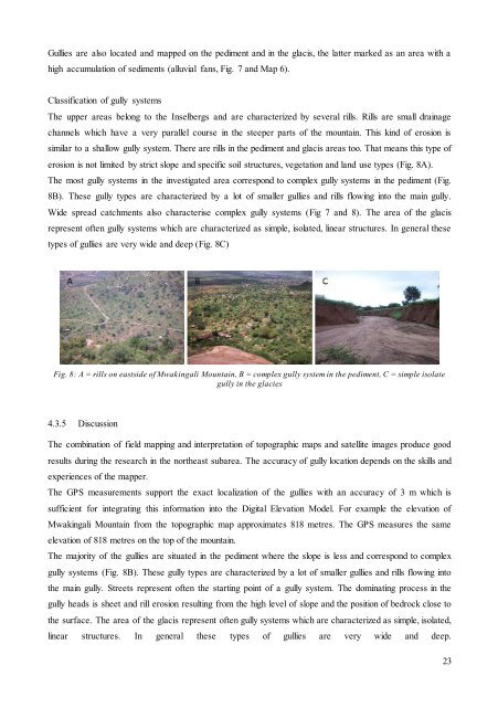
Classification of gully systems<br />
The upper areas belong to the Inselbergs <strong>and</strong> are characterized by several rills. Rills are small drainage<br />
channels which have a very parallel course in the steeper parts of the mountain. This kind of erosion is<br />
similar to a shallow gully system. There are rills in the pediment <strong>and</strong> glacis areas too. That means this type of<br />
erosion is not limited by strict slope <strong>and</strong> specific soil structures, vegetation <strong>and</strong> l<strong>and</strong> use types (Fig. 8A).<br />
The most gully systems in the investigated area correspond to complex gully systems in the pediment (Fig.<br />
8B). These gully types are characterized by a lot of smaller gullies <strong>and</strong> rills flowing into the main gully.<br />
Wide spread catchments also characterise complex gully systems (Fig 7 <strong>and</strong> 8). The area of the glacis<br />
represent often gully systems which are characterized as simple, isolated, linear structures. In general these<br />
types of gullies are very wide <strong>and</strong> deep (Fig. 8C)<br />
Fig. 8: A = rills on eastside of Mwakingali Mountain, B = complex gully system in the pediment, C = simple isolate<br />
gully in the glacies<br />
4.3.5 Discussion<br />
The combination of field mapping <strong>and</strong> interpretation of topographic maps <strong>and</strong> satellite images produce good<br />
results during the research in the northeast subarea. The accuracy of gully location depends on the skills <strong>and</strong><br />
experiences of the mapper.<br />
The GPS measurements support the exact localization of the gullies with an accuracy of 3 m which is<br />
sufficient for integrating this information into the Digital Elevation Model. For example the elevation of<br />
Mwakingali Mountain from the topographic map approximates 818 metres. The GPS measures the same<br />
elevation of 818 metres on the top of the mountain.<br />
The majority of the gullies are situated in the pediment where the slope is less <strong>and</strong> correspond to complex<br />
gully systems (Fig. 8B). These gully types are characterized by a lot of smaller gullies <strong>and</strong> rills flowing into<br />
the main gully. Streets represent often the starting point of a gully system. The dominating process in the<br />
gully heads is sheet <strong>and</strong> rill erosion resulting from the high level of slope <strong>and</strong> the position of bedrock close to<br />
the surface. The area of the glacis represent often gully systems which are characterized as simple, isolated,<br />
linear structures. In general these types of gullies are very wide <strong>and</strong> deep.<br />
23