Soil Erosion and Flood Risk Management
Soil Erosion and Flood Risk Management
Soil Erosion and Flood Risk Management

You also want an ePaper? Increase the reach of your titles
YUMPU automatically turns print PDFs into web optimized ePapers that Google loves.
Three main gully types were selected to describe the variety of the morphological features of the 20<br />
investigated gully profiles. It was found out, that one of the main factors, which can change the gully<br />
genesis, is the variation of slope inclination.<br />
At the slope area with a high amount of bedrock occurrence the starting point of the rills <strong>and</strong> the gully<br />
heads were located. In this area the slope inclination is very high. This could be the reason why the<br />
investigated gully is in this part deep <strong>and</strong> side erosion take place. After a few meters downhill the<br />
gully began to me<strong>and</strong>er <strong>and</strong> deposition of sediments starts to decrease the depth of the gully.<br />
The first cross profile was taken a few meters after the two rills enter in the gully head. The slope in<br />
this area is very steep with bedrock. The gully walls are high (ca. 4.0 m) <strong>and</strong> the average width at the<br />
bottom of the gully is small (ca.3,50 m).<br />
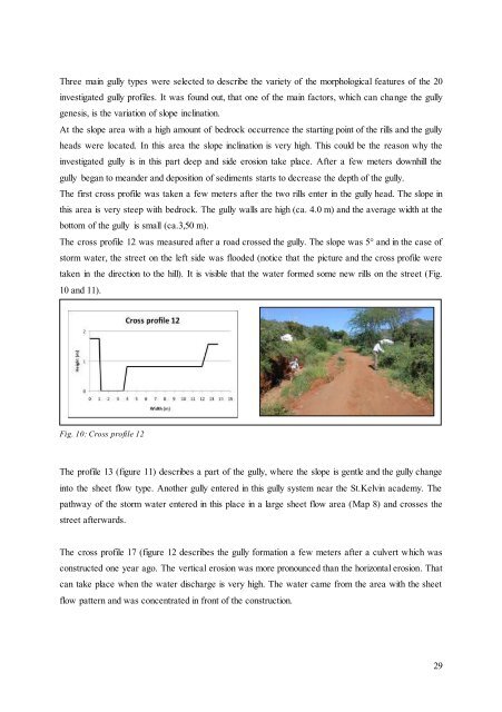
The cross profile 12 was measured after a road crossed the gully. The slope was 5° <strong>and</strong> in the case of<br />
storm water, the street on the left side was flooded (notice that the picture <strong>and</strong> the cross profile were<br />
taken in the direction to the hill). It is visible that the water formed some new rills on the street (Fig.<br />
10 <strong>and</strong> 11).<br />
Fig. 10: Cross profile 12<br />
The profile 13 (figure 11) describes a part of the gully, where the slope is gentle <strong>and</strong> the gully change<br />
into the sheet flow type. Another gully entered in this gully system near the St.Kelvin academy. The<br />
pathway of the storm water entered in this place in a large sheet flow area (Map 8) <strong>and</strong> crosses the<br />
street afterwards.<br />
The cross profile 17 (figure 12 describes the gully formation a few meters after a culvert which was<br />
constructed one year ago. The vertical erosion was more pronounced than the horizontal erosion. That<br />
can take place when the water discharge is very high. The water came from the area with the sheet<br />
flow pattern <strong>and</strong> was concentrated in front of the construction.<br />
29