- Page 1 and 2:
Aft'. •W-* ••«f X 0- ^ftj, O
- Page 6 and 7:
' •v ly A i A UUAN CHACU INDIANS.
- Page 9 and 10:
q, g-L^^ V \'=\ A PARTING WORD. N c
- Page 11 and 12:
A PAETENG WORD. v teen swayed by an
- Page 13 and 14:
A Paetino Woed CHAP. — CONTENTS.
- Page 15 and 16:
South America (upper part) South Am
- Page 17:
FIO. LIST OF ILLUSTEATIONS.
- Page 20 and 21:
2 AMAZONIA AND LA PLATA. Amazons, a
- Page 22 and 23:
4 AMAZONIA AND LA PLATA. the Amacur
- Page 24 and 25:
6 AMAZONIA AND LA PLATA. Barrere an
- Page 26:
8 AMAZONIA AND LA PLATA. Towards th
- Page 30 and 31:
10 AMAZONIA AND LA PLATA. tropical
- Page 32 and 33:
12 AMAZONIA AND LA PLATA. the Venez
- Page 34 and 35:
14 AMAZONIA AND LA PLATA. The Potar
- Page 36 and 37:
16 AMLiZONIA AND LA PLATA. But ttis
- Page 38 and 39:
18 AMAZONLV AXD LA TLATA. are cease
- Page 40 and 41:
20 AILVZONIA AND LA PLATA. The rive
- Page 42 and 43:
22 AMAZONIA AND LA PLATA. the sands
- Page 44 and 45:
24 AMAZONIA AND LA PLATA. current.
- Page 46 and 47:
26 AMAZONIA AND LA PLATA. dense haz
- Page 48 and 49:
28 AMAZONIA AKD LA PLATA. As the gr
- Page 50 and 51:
30 AMAZONIA AND LA PLATA. than that
- Page 52 and 53:
32 AMAZONIA AND LA PLATA. In Britis
- Page 54 and 55:
48 AMAZONIA AND LA PLATA. about a b
- Page 56 and 57:
34 AMAZONIA AND LA PLATA. hand a wh
- Page 58 and 59:
80 AMAZONIA AND LA PLATA. is deemed
- Page 61 and 62:
INHABITANTS OF GUIANA. 87 the Carib
- Page 63 and 64:
INHABITANTS OF GUIANA. 39 kiudred.
- Page 65 and 66:
• but INHABITANTS OF GUIANA. 41 p
- Page 67 and 68:
INHABITANTS OF GUIANA. 43 fathers a
- Page 69 and 70:
INHABITANTS OF GUIANA. 45 " Postlio
- Page 72 and 73:
». ~ S'MARTA "P*GalhBas «WARACA _
- Page 75 and 76:
BRITISH GUIANA. 49 Spanish stations
- Page 77 and 78:
BEITISn GUIANA. 61 A few miles to t
- Page 79 and 80:
BRITISH GUIANA. 53 Material Conditi
- Page 81 and 82:
BRITISH GUIANA. 55 Tie so-called "
- Page 83 and 84:
DUTCH GUIANA. 57 continually encroa
- Page 85 and 86:
DUTCH GUIANA. 59 Paramaribo is soon
- Page 87 and 88:
DUTCH GUIANA. 61 recently the miner
- Page 89 and 90:
FEENCH GUIANA. 63 succumbed at last
- Page 91 and 92:
FEENCH GUIANA. 65 The Mana river, w
- Page 93:
3 O Z J
- Page 96 and 97:
68 AMAZONIA AND LA TLATA. especiall
- Page 98 and 99:
70 AMAZONIA AND LA PLATA. wliole co
- Page 100 and 101:
72 AMAZONIA AND LA PLATA. independe
- Page 102 and 103:
74 AMAZONIA AND LA PLATA. Meanwhile
- Page 104:
76 AMAZONIA AND LA PLATA. Para is d
- Page 107 and 108:
BEAZIL—GENERAL SUEVEY. 79 Portuga
- Page 109 and 110:
BRAZIL—GENER-iL SURVEY. 81 de Jan
- Page 111 and 112:
BRAZIL—GENERAL SURVEY. 83 onlj' u
- Page 113 and 114:
BRAZIL—GENERAL SLTiVEY. 85 to ups
- Page 115 and 116:
BRAZIL—GENEEAL SURVEY. 87 belong
- Page 117 and 118:
BRAZIL—GENERAL SURVEY. 80 of pure
- Page 119:
* w^t' — g^—t^^i^^ ' - • TT'-
- Page 122 and 123:
92 AMAZONIA AND LA PLATA. the Andes
- Page 124 and 125:
94 AMAZONIA AND LA PLATA. It has it
- Page 126 and 127:
93 AMAZONIA AND LA PLATA. ia an upl
- Page 129 and 130:
EIVEES OF AMAZONIA. 97 route has be
- Page 131 and 132:
ElVEES OP AMAZONIA. 99 doubt ttat a
- Page 133:
A ao
- Page 136 and 137:
102 AMAZONIA AND LA PLATA. Salinas
- Page 138 and 139:
104 AMAZONIA AND LA PLATA. Atlantic
- Page 140 and 141:
106 AMAZONIA AND LA PLATA. trees at
- Page 142 and 143:
108 AMAZONIA AND LA PLATA. Inhabita
- Page 145 and 146:
INHABITANTS OF AMAZONIA. 109 on the
- Page 147 and 148:
INHABITANTS OF AMAZONIA. Ill hostil
- Page 149 and 150:
INHABITANTS OF AMAZONIA. 113 baptiz
- Page 151 and 152:
TOPOGRAPHY OF AMAZONIA. 115 soutt s
- Page 153 and 154:
TOPOGEAPnY OTT AMAZONIA. 117 Grosso
- Page 157 and 158:
TOPOGRAPHY OF iVMAZONIA. 119 inercl
- Page 159 and 160:
TOPOGRArnY OF AMAZONIA. 121 Itnifub
- Page 161:
S^ ^ > S o
- Page 164:
124 AMAZONTA AXD LA PLATA. 1850 the
- Page 169 and 170:
CHAPTER VII. THE T0CA:IS!TINS BASES
- Page 171 and 172:
TOCANTINS BASrST. 127 Both as regar
- Page 173 and 174:
INHABITANTS OF GOYAZ. 129 rains whi
- Page 175:
^fc aPW" w^&m. ?a^^==efeiSl :~3^:^a
- Page 178 and 179:
132 AMAZONIA AND LA PLATA. " the be
- Page 180 and 181:
134 AMAZONIA AND LA PLATA. followin
- Page 182 and 183:
186 AMAZONIA AND LA PLATA. ance of
- Page 184 and 185:
138 AMAZONIA AND LA PLATA. becomes
- Page 186 and 187:
140 AMAZONIA AND LA PLATA. tropical
- Page 188 and 189:
142 AMAZ0NL4. AND LA PLATA. water s
- Page 190 and 191:
144 AilAZOXIA AND LA TLATA. Eio Mos
- Page 193 and 194:
TOPOGEAPHY OF PEENAMBUCO. 145 and f
- Page 195 and 196:
PERNAMBUCO. H7 side of the channel
- Page 197:
M v^i,' /^
- Page 200 and 201:
150 AMAZONIA AND LA PLATA. receives
- Page 202 and 203:
^^^ CHAPTER IX.
- Page 205 and 206:
STATES OF THE S. FRANCISCO BASIN. 1
- Page 207 and 208:
S. FEANCISCO BASIN. 155 geological
- Page 211 and 212:
S. FKANCISCO BASiy. 157 the Rio Ver
- Page 213 and 214:
TUE LITTLE S. FILiNCISCO. 159 The R
- Page 215 and 216:
THE ABEOLHOS EEEFS. Between the Jeq
- Page 217 and 218:
INHABITAXTS—THE BOTOCTTDOS. 163 a
- Page 219 and 220:
ABORIGINES OF EAST BEAZIL. 165 they
- Page 221 and 222:
TOPOGEAPHT—QUELUZ. 167 from tlie
- Page 223 and 224:
TOPOGEAPHY—DIAMANTINA. 1G9 the ve
- Page 225 and 226:
TOPOGEAPHY—JOAZEIEO. 171 Fartter
- Page 227 and 228:
TOPOGEAPHT —BAHL*.. 173 by Dio»o
- Page 229 and 230:
TOPOGEAPHT—CACHOEIEA. 175 by arti
- Page 231 and 232:
yiCTOEIA. 177 This place stands at
- Page 234 and 235:
-TV.. Gu&Tdtiba ::N.S.d*5»ude S.An
- Page 238 and 239:
180 AMAZONIA AND LA PLATA. of unifo
- Page 240 and 241:
182 AMAZONIA AND LA PLATA. Westward
- Page 242 and 243:
184 AMAZONIA AND LA PLATA. the floo
- Page 245 and 246:
CLIMATE OF EIO DE JAXEIEO. 1S5 at o
- Page 247 and 248:
INHABITANTS OF EIO DE JANEIRO. 187
- Page 249 and 250:
TOPOGRAPHY OP EIO DE JANEIRO. 189 e
- Page 251:
H!i'"''l»"il:!:iBITi':!i'llll:ail!
- Page 254 and 255:
192 AMAZONIA AND LA PLATA. up the s
- Page 256 and 257:
194 AMAZONIA AND LA PLATA. veniiig
- Page 258 and 259:
196 AMj^ONIA and la PLATA. Morro de
- Page 261 and 262:
PETEOPOLIS. 107 on the globe. " "Wi
- Page 263 and 264:
CHArXER XI. PAR.'LNA SLOPE A^T> ADJ
- Page 265 and 266:
CONGESTED BE-VZILO-AEGEXTIXE FRONTI
- Page 267 and 268:
PHYSICAL FEATUEES OF THE PAEANA STA
- Page 269 and 270:
HYDEOGBAPHY OF THE PAEAXA STATES. 2
- Page 271 and 272:
THE EIO PAEAXA BASIN. 207 inner slo
- Page 273 and 274:
THE PAEANA BASIN. 209 as the Rio Gr
- Page 277 and 278:
FLORA OF S. PAULO. 211 On the Campo
- Page 279 and 280:
INHABIT.VXTS OF THE PARANA KEGIOXS.
- Page 281 and 282:
TOPOGEAPHT OF illNAS GEBAES. 215 Ne
- Page 283 and 284:
TOPOGRAPHY OF MDfAS GERAES. 217 sel
- Page 285 and 286:
TOPOGRAPHY OF illXAS GEEAES. Ifahoa
- Page 287 and 288:
TOrOGEAPHY OF S. TAULO. 221 new dis
- Page 291 and 292:
TOPOGRAPHY OF S. PAULO. 223 and rel
- Page 293 and 294:
TOPOQEArnT OF S. PAULO. 92.n Farthe
- Page 295:
k D z
- Page 298 and 299:
22S AilAZONIA AXD LA PLATA. j'ields
- Page 300 and 301:
230 AMAZONIA AND LA PLATA. Iguazu w
- Page 302 and 303:
232 Scale 1 : 540,000. AMAZOXIA AND
- Page 304 and 305:
^^gjl^mi i
- Page 306 and 307:
236 AMAZONIA AND LA PLATA. Rio Gran
- Page 308 and 309:
238 AM^VZONIA AND LA PLATA. 3,500 s
- Page 310 and 311:
240 AilAZONIA AND LA PLATA. greates
- Page 312 and 313:
242 AMAZONIA AND LA PLATA. land. Bu
- Page 314 and 315:
244 AMAZONIA AND LA PLATA. whidi ex
- Page 316 and 317:
21G AM.VZONIA A^'D LA PLATA. "Norte
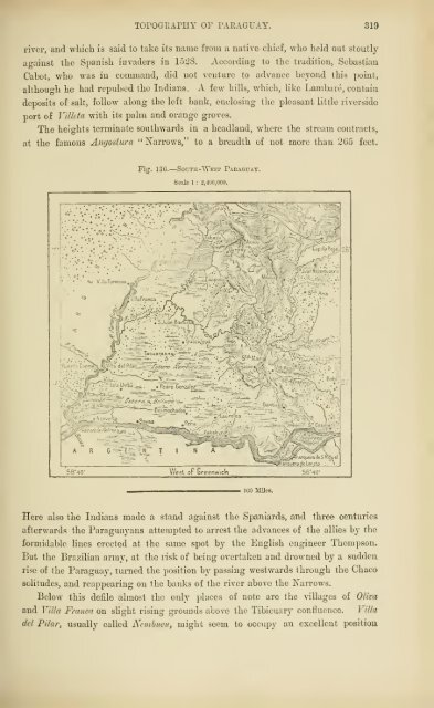
- Page 318 and 319:
248 AMAZONIA AND LA PLATA. gold, an
- Page 320:
250 AMAZOXTA AND LA PLATA. Grosso.
- Page 324 and 325:
252 AMAZONIA AND LA TLATA The divid
- Page 326 and 327:
254 AMAZONIA AND LA PLATA. Rivers:
- Page 328 and 329:
25G . AMAZONIA AND LA PLATA. from t
- Page 330 and 331:
258 AMAZONIA AND LA PLATA. search o
- Page 333 and 334:
INHABITANTS OF MATTO GROSSO. 259 th
- Page 335 and 336:
TOPOGRAPHY OF MAITO GEOSSO. 261 cen
- Page 337 and 338:
CHAPTER XIV. MATERIAL AND SOCIAL CO
- Page 339 and 340:
SOCIAL CONDITION OF BRAZIL. 265 ste
- Page 341 and 342:
SOCIAL COXDITIOX OF BRAZIL. 267 nea
- Page 343 and 344:
EESOUECES OF BR^VZIL—AGRICULTURE.
- Page 345:
- Page 348 and 349: 272 AMAZONIA AND LA PLATA. Monarchi
- Page 350 and 351: 274 AMAZONIA AND LA PLATA. depth of
- Page 352 and 353: 27G AilAZONIA AND LA PLATA. round D
- Page 355 and 356: DTDUSTKIES OF BILVZIL. 277 have now
- Page 357 and 358: COiriTTNTiCATIOXS OF BRAZIL. 279 ra
- Page 359 and 360: RAILWAYS OF BRAZIL. 281 majority be
- Page 361 and 362: STATE OF EDUCATION, BRAZIL. 283 com
- Page 363 and 364: CONSTITUTION OF BRAZIL. 285 GOVF.KN
- Page 365 and 366: CONSTITUTION OF BEAZIL. 287 Each of
- Page 367 and 368: ADMINISTBATION OF BRAZIL. 289 sons.
- Page 369 and 370: ADinXISTEATION OF BEAZIL, 291 "town
- Page 371 and 372: H15T0EY OF PARAGUAY. 293 8 ill hope
- Page 373 and 374: mSTOET OF PAEAGUAY. 295 suddenly ch
- Page 375 and 376: GEOGRAPHICAL EESEAECH, PARAGUAY. 29
- Page 377 and 378: TvIVEES OF PAEAGrAT. 299 soil is ex
- Page 379 and 380: EIVEBS OP PARAGUAY. 301 becomes mor
- Page 381 and 382: CLIMATE AND FLOEA OF PAEAGUAT. 803
- Page 383 and 384: FAUNA OF PARAGUAY. 305 the capyvara
- Page 385: 3 Z T. < 25 3
- Page 388 and 389: 808 AAIAZOXIA AND LA PLATA. loins g
- Page 390 and 391: 310 AMAZONIA AND LA PLATA. order to
- Page 392 and 393: 312 AMAZONIA AXD LA PLATA. popular.
- Page 394 and 395: 814 AMAZONIA AND LA TLATA. Villa Az
- Page 396 and 397: 31G AMAZONIA AND LA PLATA. Villa Ei
- Page 400 and 401: 320 AMAZONIA AND LA PLATA. between
- Page 403 and 404: MATERIAL COXDITION OP PARAGUAY. 821
- Page 405 and 406: RESOURCES OP PAEAQUAY. 823 caa nana
- Page 407: ^ n 33 z. o a < a p z o
- Page 410 and 411: 826 AMAZONIA AND LA PLATA. a yard o
- Page 412 and 413: 328 AMAZONIA AND LA PLATA. difficul
- Page 414 and 415: 330 AMLAZONIA AND LA PLATA. rapid p
- Page 416 and 417: 832 A3IAZ0XIA AND LA PLATA. Uruguay
- Page 418 and 419: 334 AMAZONIA AND LA PLATA. distribu
- Page 420: 336 AMAZONIA AND LA PLATA. these co
- Page 424 and 425: 888 AMAZONIA AND LA PLATA. to rank
- Page 426 and 427: 340 AMAZONIA AND LA PLATA. Agricult
- Page 428 and 429: 842 AMAZONIA AND LA PLATA. other ha
- Page 430: CHAPTER XVII. Argentina. 'OTH in ex
- Page 433: ^ AND THE ESTUARY. \ X anco • ic'
- Page 436 and 437: 340 AMAZONIA AND LA PLATA. Guaycuru
- Page 439 and 440: EXPLORATION OF AEGEXTINA. 347 But a
- Page 441 and 442: BOUXDABIES OF AEGENTINA. 349 taken
- Page 443 and 444: THE AEGEN-TDTE PEOPLE. 351 Akgextix
- Page 445 and 446: THE AEGENTINE UPLANDS. 353 and Nort
- Page 447 and 448: THE AEGEXTINE UPLANDS. 355 Hauthal
- Page 449:
a K o n O >o > o
- Page 452 and 453:
358 AMAZONIA AND LA PLATA. view ext
- Page 454 and 455:
360 AMAZONIA AND LA PLATA. former e
- Page 456 and 457:
862 AMAZONIA AND LA PLATA. Bay, Por
- Page 458 and 459:
864 AMAZONIA AND LA PLATA. appear t
- Page 460 and 461:
866 AMAZONIA AND LA PLATA. hills, w
- Page 462 and 463:
3G8 AMAZONIA AND LA PLATA. are, on
- Page 464 and 465:
870 AMAZONIA AND LA PLATA. larger t
- Page 466 and 467:
372 AMA7.0XIA AND LA PLATA. between
- Page 468:
374 AMAZONIA AND LA PLATA. infested
- Page 472 and 473:
376 AMAZONIA AND LA PLATA. equal to
- Page 474 and 475:
878 AMAZONIA AND LA PLATA. sudden i
- Page 476 and 477:
380 AMAZONIA AND LA PLATA. Tunuyan,
- Page 478 and 479:
382 AMAZONIA AND LA PLATA. easily f
- Page 481 and 482:
LAKES AND ETTEBS OF PATAGONIA. 388
- Page 483 and 484:
LAKES AND EIVEES OF PATAGONIA. 885
- Page 485 and 486:
LAKES A^'D ETS'EBS OF PATAGOXIA. 88
- Page 487 and 488:
LAKES AXD EIYERS OF PATAGONIA. 889
- Page 489 and 490:
THE PATAGONIAN SEABOARD. 391 South
- Page 491 and 492:
CLIMATE OF AEGEXTIXA. S93 to these
- Page 493 and 494:
CLIMATE OF AEGEXTDsA. 395 the pumas
- Page 495 and 496:
FLORA OF AEGENTIXA. 897 sucli a tan
- Page 497 and 498:
FAUNA OP AEQENTINA. 899 tHe animal
- Page 499 and 500:
FAUNA OF AEGENTINA 401 ness, or com
- Page 501 and 502:
FAUNA OF ARGENTINA. 403 to the gate
- Page 503 and 504:
INHABITAXTS OF ARGENTINA. 405 by gr
- Page 505 and 506:
IXHABITAXTS OF AEGENTINA. 407 Spani
- Page 507 and 508:
INHABITANTS OF AHQENTINA. 409 names
- Page 509 and 510:
INHABITANTS OF ARGENTINA. 411 tteir
- Page 511 and 512:
INHABITANTS OF AEGENTINA. 418 Pass.
- Page 515 and 516:
INHABITANTS OP ARGENTINA. 419 All t
- Page 517 and 518:
INHABITANTS OF AEGENTINA. . 417 rel
- Page 519:
D
- Page 522 and 523:
420 AMAZOJfIA AND LA PLATA. industr
- Page 524 and 525:
422 AMAZONIA AND LA PLATA. successi
- Page 526 and 527:
424 AMAZONIA AND LA PLATA. supplied
- Page 528 and 529:
426 AMAZONIA AND LA PLATA. lands in
- Page 530 and 531:
428 AMAZONIA AND LA PLATA. delta ;
- Page 532:
480 AMAZONIA AXD LA PLATA. locally
- Page 536 and 537:
432 AMAZONIA AND LA PLATA. independ
- Page 538 and 539:
434 AMAZONIA AND LA PLATA. here ram
- Page 540 and 541:
436 AMAZOmA AND LA PLATA. mines wer
- Page 542 and 543:
438 tion of less than 15,000. AMAZO
- Page 545 and 546:
TOPOGRArUY OF AEGEXTINA. 439 ing pl
- Page 547 and 548:
TOPOGEAPHY OF AEQENTINA. 441 arerag
- Page 549 and 550:
TOPOGEAPnY OF AEGEXTIXA. 443 They w
- Page 551 and 552:
TOPOGE.iPIIY OF AEGENTINA. 445 dang
- Page 553 and 554:
TOPOGEArHT OF AEGENTINA 447 when th
- Page 555:
o -J o
- Page 558 and 559:
450 AMAZONIA AND LA PLATA. The City
- Page 560 and 561:
452 AMAZONIA AND LA PLATA. near Mar
- Page 562 and 563:
454 AMAZONIA AKD LA PLATA. Southwar
- Page 564 and 565:
450 AMAZONIA AND LA PLATA. Colorado
- Page 567 and 568:
TOPOGRAPET OF AEGEXTINA. 457 To rea
- Page 569 and 570:
TOPOGEAPHY OF AEGENTINA. 459 Nevert
- Page 571 and 572:
TOPOGRAPHY OF AEGEXTrN'A. 4G1 is al
- Page 573 and 574:
MATEEIAL COXDITION OF AEGEXTDCA. 40
- Page 575:
o -r; < o H O
- Page 578 and 579:
400 AMAZONIA AND LA PLATA. Aguicui.
- Page 580 and 581:
4G8 AMAZONIA AND LA FLATA. the free
- Page 582 and 583:
470 AMAZONIA AND LA PLATA. Art^enti
- Page 584 and 585:
472 AMAZONIA AND LA PLATA. at heavy
- Page 586 and 587:
471 A3J:AZ0NIA and la PLATA. third
- Page 588 and 589:
47G AILVZONIA AND LA PLATA. Religio
- Page 590 and 591:
478 AMAZONIA AND LA PLATA. settler
- Page 592 and 593:
480 AMAZONIA AND LA PLATA. selected
- Page 594 and 595:
482 A5IAZ0>nA AND LA PLATA. "•lac
- Page 596 and 597:
484 Area, 50,000 sq. miles ; APPEND
- Page 598 and 599:
486 APPENDIX. CHEEF TOWNS OF THE PA
- Page 600 and 601:
488 APPENDIX. 1796 1829 1852 Area,
- Page 602 and 603:
490 Posadas Formosa Kcsistencia APr
- Page 604 and 605:
492 APPENDIX. FALKLAND ISLANDS AND
- Page 606 and 607:
494 Borbico, Eio, 16 Town, 52 Berra
- Page 608 and 609:
496 Guianaa Indians, 32 Guiana, Bri
- Page 610 and 611:
498 Paranapanema, Rio, 208 Parana-
- Page 612 and 613:
500 Tronador Mountain, SCO Tubarao,
- Page 614:
SUPPLIED TO SUBSCRIBERS ONLY. In Fi


![The Philosophy of Progress [pdf]](https://img.yumpu.com/14077359/1/190x245/the-philosophy-of-progress-pdf.jpg?quality=85)