uct heritage park management framework - University of Cape Town
uct heritage park management framework - University of Cape Town
uct heritage park management framework - University of Cape Town

You also want an ePaper? Increase the reach of your titles
YUMPU automatically turns print PDFs into web optimized ePapers that Google loves.
34<br />
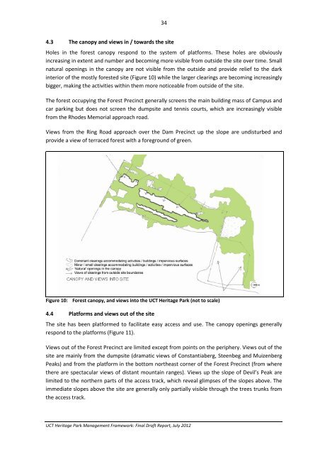
4.3 The canopy and views in / towards the site<br />
Holes in the forest canopy respond to the system <strong>of</strong> platforms. These holes are obviously<br />
increasing in extent and number and becoming more visible from outside the site over time. Small<br />
natural openings in the canopy are not visible from the outside and provide relief to the dark<br />
interior <strong>of</strong> the mostly forested site (Figure 10) while the larger clearings are becoming increasingly<br />
bigger, making the activities within them more noticeable from outside <strong>of</strong> the site.<br />
The forest occupying the Forest Precinct generally screens the main building mass <strong>of</strong> Campus and<br />
car <strong>park</strong>ing but does not screen the dumpsite and tennis courts, which are increasingly visible<br />
from the Rhodes Memorial approach road.<br />
Views from the Ring Road approach over the Dam Precinct up the slope are undisturbed and<br />
provide a view <strong>of</strong> terraced forest with a foreground <strong>of</strong> green.<br />
Figure 10: Forest canopy, and views into the UCT Heritage Park (not to scale)<br />
4.4 Platforms and views out <strong>of</strong> the site<br />
The site has been platformed to facilitate easy access and use. The canopy openings generally<br />
respond to the platforms (Figure 11).<br />
Views out <strong>of</strong> the Forest Precinct are limited except from points on the periphery. Views out <strong>of</strong> the<br />
site are mainly from the dumpsite (dramatic views <strong>of</strong> Constantiaberg, Steenbeg and Muizenberg<br />
Peaks) and from the platform in the bottom northeast corner <strong>of</strong> the Forest Precinct (from where<br />
there are spectacular views <strong>of</strong> distant mountain ranges). Views up the slope <strong>of</strong> Devil’s Peak are<br />
limited to the northern parts <strong>of</strong> the access track, which reveal glimpses <strong>of</strong> the slopes above. The<br />
immediate slopes above the site are generally only partially visible through the trees trunks from<br />
the access track.<br />
UCT Heritage Park Management Framework: Final Draft Report, July 2012