HAND, a new terrain descriptor using SRTM-DEM - DPI - Inpe
HAND, a new terrain descriptor using SRTM-DEM - DPI - Inpe
HAND, a new terrain descriptor using SRTM-DEM - DPI - Inpe

You also want an ePaper? Increase the reach of your titles
YUMPU automatically turns print PDFs into web optimized ePapers that Google loves.
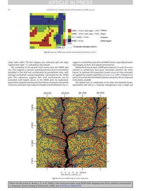
(deep water table). The last category was arbitrarily split into slope<br />
(upland with slope N3°) and plateau (flat upland).<br />
The overlaying of the ground truth points onto the <strong>HAND</strong> grid<br />
(Fig. 10b) suggests a coherent matching between local environments<br />
identified in the field and corroborated by groundwater data, with<br />
drainage-normalized canopy-topography represented by the <strong>HAND</strong><br />
grid. This coherence suggests that local environments can be<br />
associated with height classes in the <strong>HAND</strong> grid. An exploratory<br />
quantitative analysis matching the distribution of ground truth points<br />
in the Asu catchment with respective heights in the <strong>HAND</strong> grid (Fig.11)<br />
ARTICLE IN PRESS<br />
10 C.D. Rennó et al. / Remote Sensing of Environment xxx (2008) xxx-xxx<br />
Fig. 12. Four-class <strong>HAND</strong> map overlaid with ground truth points to site C1.<br />
Fig. 13. Four-class <strong>HAND</strong> map for entire study area.<br />
suggests a compelling separation of <strong>HAND</strong> classes, especially between<br />
waterlogged, ecotone and upland environments.<br />
Taking these into account, <strong>HAND</strong> grid values of 5 m and 15 m were<br />
selected as preliminary best-guess thresholds between the three<br />
classes. To optimize this separation (lessen errors on class inclusion)<br />
we applied the simplex algorithm (Cormen et al., 2001), finding 5.3 m<br />
and 15.0 m as the best thresholds between classes for the set of ground<br />
truth points available.<br />
The upland class, in comparison to the other two lowland classes,<br />
represented well and in a relatively homogeneous way a single soil<br />
Please cite this article as: Rennó, C. D., et al., <strong>HAND</strong>, a <strong>new</strong> <strong>terrain</strong> <strong>descriptor</strong> <strong>using</strong> <strong>SRTM</strong>-<strong>DEM</strong>: Mapping terra-firme rainforest environments<br />
in Amazonia, Remote Sensing of Environment (2008), doi:10.1016/j.rse.2008.03.018