HAND, a new terrain descriptor using SRTM-DEM - DPI - Inpe
HAND, a new terrain descriptor using SRTM-DEM - DPI - Inpe
HAND, a new terrain descriptor using SRTM-DEM - DPI - Inpe

Create successful ePaper yourself
Turn your PDF publications into a flip-book with our unique Google optimized e-Paper software.
data that allowed for the digital reconstruction of the surface relief,<br />
producing the <strong>DEM</strong>. The <strong>SRTM</strong>-<strong>DEM</strong> data, with a horizontal resolution<br />
of 3” (~90 m near the equator) and a vertical resolution of 1 m,<br />
constitutes the finest resolution and most accurate topographic data<br />
available for most of the globe. Detailed information on the accuracy<br />
and performance of <strong>SRTM</strong> can be found in Rodriguez et al. (2006). In<br />
contrast to the passive optical imagery, this <strong>new</strong> <strong>DEM</strong> shows the<br />
feature-rich relief of lowland rain forests, adding to the ability to<br />
identify and map rain forest environments through many quantitative<br />
<strong>terrain</strong> <strong>descriptor</strong>s.<br />
A range of topographic algorithms are available, which allow<br />
various quantitative relief features to be obtained from the <strong>DEM</strong>. Slope<br />
and aspect (e.g. Jenson and Domingue, 1988), and drainage network<br />
and catchment area (e.g. Curkendall et al., 2003) are a few classical<br />
<strong>descriptor</strong>s. A range of hydrological parameters such as superficial<br />
runoff trajectories, accumulated contributing area and groundwater<br />
related variables (e.g. Tarboton, 2003) add to the suite of relief<br />
<strong>descriptor</strong>s. Relief shape parameters such as curvatures and form<br />
factors can also be calculated (Valeriano et al., 2006). The third<br />
dimension in a <strong>DEM</strong>, height, is obviously the key parameter, used to<br />
some degree in the derivation of all of the previously mentioned<br />
<strong>descriptor</strong>s. Absolute height (above sea level — ASL) can be used on its<br />
own as a relief <strong>descriptor</strong>, as large scale geomorphologic features tend<br />
to be associated with altitude relevant geological control (Goudie,<br />
2004). Upon flooding a given catchment for hydro dam development,<br />
for example, the height ASL is the <strong>descriptor</strong> that will predict the reach<br />
of the impoundment. However, when local environments in the fine<br />
scale relief are considered, height ASL has little, if any, descriptive<br />
power. As a result, local scale environments, although of conspicuous<br />
importance and clearly defined by characteristic <strong>terrain</strong> topography<br />
that is clearly visible on the <strong>SRTM</strong>-<strong>DEM</strong>, have not so far had a good<br />
<strong>descriptor</strong>.<br />
In this paper we present the development of a <strong>new</strong> quantitative<br />
topographic algorithm based on <strong>SRTM</strong>-<strong>DEM</strong> data. We crafted and<br />
tested the <strong>terrain</strong> <strong>descriptor</strong>, applying it for a groundwater, topographic<br />
and vegetation dataset from central Amazonia, <strong>using</strong> ground<br />
calibrated <strong>terrain</strong> classes for mapping the study area.<br />
2. Algorithm development<br />
2.1. Conditioning procedures<br />
The <strong>new</strong> <strong>descriptor</strong> algorithm requires a hydrologically coherent<br />
<strong>DEM</strong> as input, with resolved depressions (sinks), computed flow<br />
directions for each grid point and a defined drainage network. The<br />
procedures to develop these are presented below.<br />
2.1.1. Fixing <strong>DEM</strong> topology and computing flow directions<br />
Topography is a hydrologic driver since it defines the direction and<br />
speed of flows. Flow directions define hydrological relations between<br />
different points within a basin. Topological continuity for the flow<br />
directions is therefore necessary for a functional drainage to exist.<br />
Hydrological connections by flow direction between two points on a<br />
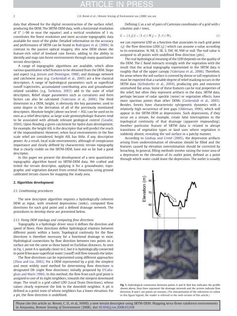
surface are not the same as those based on Euclidian distances. As seen<br />
in Fig. 1, point A is spatially closer to C, but it is hydrologically connected<br />
to point B because superficial water (runoff) will flow towards the latter.<br />
The flow directions can be represented <strong>using</strong> different approaches<br />
(Zhou and Liu, 2002). For a <strong>DEM</strong> represented by a grid, the simplest<br />
and most widely used method for determining flow directions is<br />
designated D8 (eight flow directions) initially proposed by O'Callaghan<br />
and Mark (1984). In this method, the flow from each grid point is<br />
assigned to one of its eight neighbors, towards the steepest downward<br />
slope. The result is a grid called LDD (Local Drain Directions), whose<br />
values clearly represent the link to the downhill neighbor. A pit is<br />
defined as a point none of whose neighbors has a lower elevation. For<br />
a pit, the flow direction is undefined.<br />
ARTICLE IN PRESS<br />
2 C.D. Rennó et al. / Remote Sensing of Environment xxx (2008) xxx-xxx<br />
Defining G as a set of pairs of Cartesian coordinates of a grid with c<br />
columns and r rows,<br />
G ¼ fhi; jiji ¼ ½1; cŠoN;<br />
j ¼ ½1; rŠoNg;<br />
ð1Þ<br />
we can represent LDD as a function that associates to each grid point<br />
hi,ji the flow direction LDD(hi,ji) which can assume a value according<br />
to its orientation: N, NE, E, SE, S, SW, W, NW or null. The null value is<br />
assigned to all points with undefined flow direction (pits).<br />
The real hydrological meaning of the LDD depends on the quality of<br />
the <strong>DEM</strong>. The C Band interacts strongly with the vegetation with the<br />
result that the actual topography represented in the <strong>SRTM</strong> data is<br />
roughly that of the upper canopy (Valeriano et al., 2006). Therefore,<br />
for areas where the soil surface is covered by dense or tall vegetation it<br />
must be expected that a variable degree of relief masking occurs in the<br />
<strong>SRTM</strong> data (Kellndorfer et al., 2004), producing pits and extensive<br />
unresolved flat areas. Some of these features can be real properties of<br />
the relief, but often they represent artifacts in the data. <strong>SRTM</strong> data,<br />
perhaps because of radar speckle (noise) or vegetation effects, have<br />
more spurious points than other <strong>DEM</strong>s (Curkendall et al., 2003).<br />
Besides, forests have characteristic sylvigenetic dynamics with a<br />
relatively high occurrence of tree gaps (Oldeman, 1990), which will<br />
appear in the <strong>SRTM</strong>-<strong>DEM</strong> as depressions. Such depressions, if they<br />
occur on a stream, for example, create false interruptions in the<br />
topological continuity of that drainage (apparent impounding).<br />
Another particular feature of <strong>SRTM</strong> data is related to abrupt<br />
transitions of vegetation types or land uses where vegetation is<br />
suddenly absent, revealing the soil surface in a patchy manner.<br />
According to Lindsay and Creed (2005), the depression artifacts<br />
arising from underestimation of elevation should be filled and the<br />
features caused by elevation overestimation should be corrected by<br />
breaching. In general, filling methods involve raising the inner area of<br />
a depression to the elevation of its outlet point, defined as a point<br />
through which water could leave the depression. The outlet is usually<br />
Fig. 1. Hydrological connection between points A and B. Red line indicates the profile<br />
shown above, blue lines represent the drainage network and the arrows indicate flow<br />
direction. B and C are points on streams. (For interpretation of the references to colour<br />
in this figure legend, the reader is referred to the web version of this article.)<br />
Please cite this article as: Rennó, C. D., et al., <strong>HAND</strong>, a <strong>new</strong> <strong>terrain</strong> <strong>descriptor</strong> <strong>using</strong> <strong>SRTM</strong>-<strong>DEM</strong>: Mapping terra-firme rainforest environments<br />
in Amazonia, Remote Sensing of Environment (2008), doi:10.1016/j.rse.2008.03.018