STRIVE - Environmental Protection Agency
STRIVE - Environmental Protection Agency
STRIVE - Environmental Protection Agency

You also want an ePaper? Increase the reach of your titles
YUMPU automatically turns print PDFs into web optimized ePapers that Google loves.
2 Methodology<br />
Molecular Diversity and Dynamics of Toxigenic Blue-green Algae in Irish Lakes<br />
2.1 Sampling Strategy Design for the<br />
2009 Summer Survey<br />
Database management tools in ArcGIS were used<br />
to design a sampling strategy of water bodies based<br />
on attributes of river catchments from the west and<br />
northwest of Ireland.<br />
2.1.1 Study Area, Target Population and Sample<br />
Size<br />
Sampling was carried out over a period of 15 weeks<br />
during the summer of 2009 (26 May to 3 September)<br />
extending in latitude from 52°20’ south to 55°10’ north,<br />
with a surface area of ~40,000 km2 and a population<br />
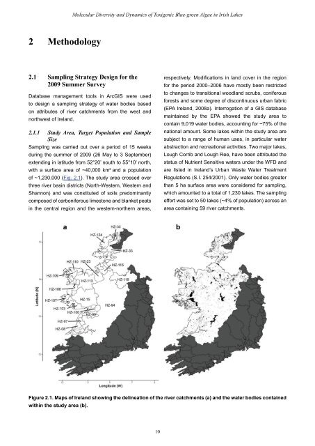
of ~1,230,000 (Fig. 2.1). The study area crossed over<br />
three river basin districts (North-Western, Western and<br />
Shannon) and was constituted of soils predominantly<br />
composed of carboniferous limestone and blanket peats<br />
in the central region and the western-northern areas,<br />
10<br />
respectively. Modifications in land cover in the region<br />
for the period 2000–2006 have mostly been restricted<br />
to changes to transitional woodland scrubs, coniferous<br />
forests and some degree of discontinuous urban fabric<br />
(EPA Ireland, 2008a). Interrogation of a GIS database<br />
maintained by the EPA showed the study area to<br />
contain 9,019 water bodies, accounting for ~75% of the<br />
national amount. Some lakes within the study area are<br />
subject to a range of human uses, in particular water<br />
abstraction and recreational activities. Two major lakes,<br />
Lough Corrib and Lough Ree, have been attributed the<br />
status of Nutrient Sensitive waters under the WFD and<br />
are listed in Ireland’s Urban Waste Water Treatment<br />
Regulations (S.I. 254/2001). Only water bodies greater<br />
than 5 ha surface area were considered for sampling,<br />
which amounted to a total of 1,230 lakes. The sampling<br />
effort was set to 50 lakes (~4% of population) across an<br />
area containing 59 river catchments.<br />
Figure 2.1. Maps of Ireland showing the delineation of the river catchments (a) and the water bodies contained<br />
within the study area (b).