

Tuning the CARIS implementation of CUBE for Patagonian Waters.pdf
Tuning the CARIS implementation of CUBE for Patagonian Waters.pdf
Tuning the CARIS implementation of CUBE for Patagonian Waters.pdf

You also want an ePaper? Increase the reach of your titles
YUMPU automatically turns print PDFs into web optimized ePapers that Google loves.
0<br />
-100<br />
-200<br />
-300<br />
-400<br />
3.1.1 North Patagonia Area.<br />
The geomorphology in this area can be explained mainly by differences according<br />
to <strong>the</strong> piedmont’s width. Thus <strong>the</strong> fjord’s depth is directly proportional to <strong>the</strong> width <strong>of</strong><br />
this trench.<br />
This area can be spilt into three sectors, delimited by <strong>the</strong> Jacaf Channel and <strong>the</strong><br />
Reñihue Fjord (Figure 3.1). Their differences are regulated by <strong>the</strong> absence or presence <strong>of</strong><br />
fjords. For example, in <strong>the</strong> north and south sectors (with presence <strong>of</strong> fjords), in general<br />
<strong>the</strong> sea bottom is very irregular. Extreme changes in depth are predominant in <strong>the</strong> fjords,<br />
where glacial deposits, such as moraines and drumlins, are observed. The basins have an<br />
accumulation <strong>of</strong> sediments (20 to 100 metres in thickness), highly stratified and<br />
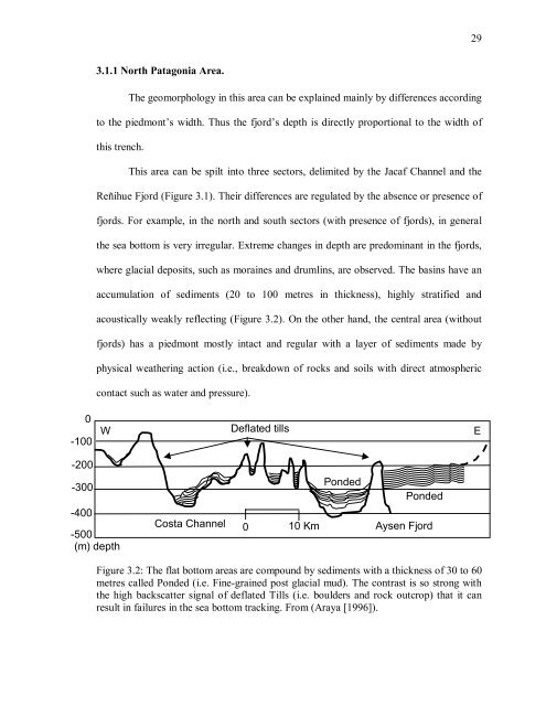
acoustically weakly reflecting (Figure 3.2). On <strong>the</strong> o<strong>the</strong>r hand, <strong>the</strong> central area (without<br />
fjords) has a piedmont mostly intact and regular with a layer <strong>of</strong> sediments made by<br />
physical wea<strong>the</strong>ring action (i.e., breakdown <strong>of</strong> rocks and soils with direct atmospheric<br />
contact such as water and pressure).<br />
W<br />
-500<br />
(m) depth<br />
Costa Channel<br />
Deflated tills<br />
Ponded<br />
Ponded<br />
0 10 Km Aysen Fjord<br />
Figure 3.2: The flat bottom areas are compound by sediments with a thickness <strong>of</strong> 30 to 60<br />
metres called Ponded (i.e. Fine-grained post glacial mud). The contrast is so strong with<br />
<strong>the</strong> high backscatter signal <strong>of</strong> deflated Tills (i.e. boulders and rock outcrop) that it can<br />
result in failures in <strong>the</strong> sea bottom tracking. From (Araya [1996]).<br />
29<br />
E


