Majority Report of the Committee Constituted to ... - Forest Rights Act
Majority Report of the Committee Constituted to ... - Forest Rights Act
Majority Report of the Committee Constituted to ... - Forest Rights Act

You also want an ePaper? Increase the reach of your titles
YUMPU automatically turns print PDFs into web optimized ePapers that Google loves.
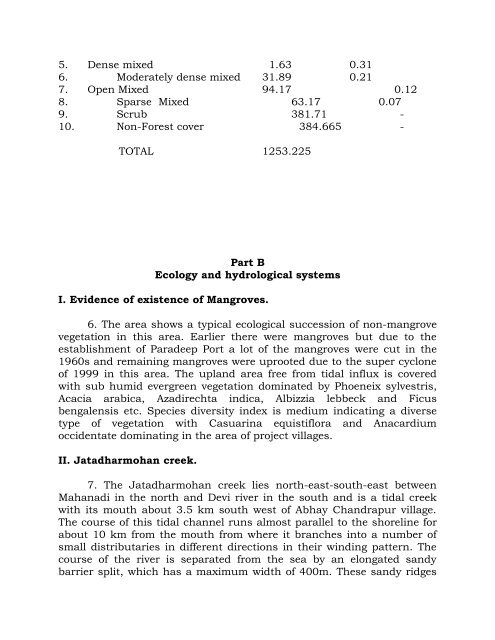
5. Dense mixed 1.63 0.31<br />
6. Moderately dense mixed 31.89 0.21<br />
7. Open Mixed 94.17 0.12<br />
8. Sparse Mixed 63.17 0.07<br />
9. Scrub 381.71 -<br />
10. Non-<strong>Forest</strong> cover 384.665 -<br />
TOTAL 1253.225<br />
Part B<br />
Ecology and hydrological systems<br />
I. Evidence <strong>of</strong> existence <strong>of</strong> Mangroves.<br />
6. The area shows a typical ecological succession <strong>of</strong> non-mangrove<br />
vegetation in this area. Earlier <strong>the</strong>re were mangroves but due <strong>to</strong> <strong>the</strong><br />
establishment <strong>of</strong> Paradeep Port a lot <strong>of</strong> <strong>the</strong> mangroves were cut in <strong>the</strong><br />
1960s and remaining mangroves were uprooted due <strong>to</strong> <strong>the</strong> super cyclone<br />
<strong>of</strong> 1999 in this area. The upland area free from tidal influx is covered<br />
with sub humid evergreen vegetation dominated by Phoeneix sylvestris,<br />
Acacia arabica, Azadirechta indica, Albizzia lebbeck and Ficus<br />
bengalensis etc. Species diversity index is medium indicating a diverse<br />
type <strong>of</strong> vegetation with Casuarina equistiflora and Anacardium<br />
occidentate dominating in <strong>the</strong> area <strong>of</strong> project villages.<br />
II. Jatadharmohan creek.<br />
7. The Jatadharmohan creek lies north-east-south-east between<br />
Mahanadi in <strong>the</strong> north and Devi river in <strong>the</strong> south and is a tidal creek<br />
with its mouth about 3.5 km south west <strong>of</strong> Abhay Chandrapur village.<br />
The course <strong>of</strong> this tidal channel runs almost parallel <strong>to</strong> <strong>the</strong> shoreline for<br />
about 10 km from <strong>the</strong> mouth from where it branches in<strong>to</strong> a number <strong>of</strong><br />
small distributaries in different directions in <strong>the</strong>ir winding pattern. The<br />
course <strong>of</strong> <strong>the</strong> river is separated from <strong>the</strong> sea by an elongated sandy<br />
barrier split, which has a maximum width <strong>of</strong> 400m. These sandy ridges