mapinfomag_spring200..
mapinfomag_spring200..
mapinfomag_spring200..

You also want an ePaper? Increase the reach of your titles
YUMPU automatically turns print PDFs into web optimized ePapers that Google loves.
14<br />
T E C H N I C A L F E A T U R E<br />
Check out MapInfo Professional v6.5<br />
By Andrew Dressel<br />
he new MapInfo Professional ®<br />
Tv6.5 gives you the power<br />
to create visual masterpieces<br />
with its new functionality:<br />
Raster Image Translucency<br />
Prism Mapping<br />
Invert Selection<br />
More Object Processing: Clean,<br />
Thin and Disaggregate<br />
TIN-based Interpolation<br />
Multipoint and Collection Objects<br />
Coordinate Extractor Tool<br />
Military Grid Reference System<br />
Coordinate Display<br />
And affords you the benefit of<br />
numerous enhancements:<br />
Improved Remote Data Support<br />
Improved Raster Image Support<br />
HTML Image Map Tool<br />
Scale Bar Tool<br />
Defaults and Preferences<br />
Expanded Most Recently Used<br />
Files List<br />
Support for More Projections:<br />
Oblique aspects of Azimuthal<br />
Equal-Area and Cassini-Soldner<br />
Translucent Raster Image Handling<br />
Of all the new features included in<br />
v6.5, translucency is the most powerful<br />
visual enhancement to raster image<br />
support. It allows you to control the<br />
amount to which other map layers<br />
show through a raster image. Now<br />
thematic maps can be combined with<br />
raster imagery to form striking images<br />
that were not possible before.<br />
SPRING 2001 MAPINFO MAGAZINE<br />
www.mapinfo.com/magazine<br />
MAPINFO PROFESSIONAL ®<br />
v6.5 HAS NEW AND ENHANCED FEATURES THAT WILL MAKE<br />
YOUR MAPS COME ALIVE! MAPINFO PROFESSIONAL v6.5 IS SHIPPING IN EARLY JUNE.<br />
TAKE A LOOK AT MAPINFO PROFESSIONAL v6.5 AT WWW.MIPRO.COM.<br />
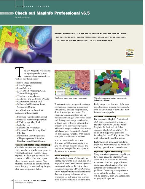
Translucency makes raster imagery more useful. With prism maps, numeric values are represented<br />
by height in a 3D view.<br />
Translucent rasters are great for telecom<br />
applications, emergency management<br />
applications, land use categorization,<br />
drive time analysis and more. For<br />
example, you can combine wire or<br />
wireless raster images with vector street<br />
and demographic maps, overlay flood<br />
or flood plain polygons with satellite<br />
imagery, layer color coded polygons<br />
with aerial imagery and stack isochrones<br />
with boundaries thematically shaded<br />
on demographic variables. With translucency,<br />
the possibilities are endless!<br />
You can vary translucency from<br />
0 percent to 100 percent, apply it to<br />
grid files as well as raster images and<br />
apply it to multiple files and layers in<br />
the same map window.<br />
Prism Mapping<br />
MapInfo Professional v6.5 includes an<br />
exciting new way to show your data on a<br />
map: prism maps. Now you can represent<br />
any numeric value as the height of the<br />
associated region in a 3D view. Combine<br />
any of MapInfo Professional’s traditional<br />
thematic mapping techniques with a<br />
prism map for a dynamic way to show<br />
more than one variable at the same time.<br />
Easily drape other features of the map,<br />
including raster imagery, labels, roads,<br />
over the 3D surface to turn a flat map<br />
into something special.<br />
Database Connectivity<br />
Data access in MapInfo Professional<br />
v6.5 has been enhanced to support<br />
the latest version of Oracle Spatial ® .<br />
MapInfo Professional v6.5 also<br />
supports MapInfo SpatialWare ® v4.5<br />
on all of its supported platforms<br />
including Microsoft ® SQL Server 2000<br />
with linked tables and live access.<br />
Performance of live access with large<br />
tables has been improved by optionally<br />
reading a precalculated record count.<br />
Improved Object Processing<br />
Many new object-processing capabilities<br />
have been added to MapInfo Professional<br />
v6.5. In addition to detecting<br />
self-intersections and gaps, this new<br />
version can also detect overlaps and<br />
automatically correct any of these<br />
problems. Correcting these problems<br />
ensures that the analysis you perform<br />
will be accurate, from area calculations<br />
to geographic queries.