Flora Biodiversity Assessment in Bonga, Boginda and Mankira Forest
Flora Biodiversity Assessment in Bonga, Boginda and Mankira Forest
Flora Biodiversity Assessment in Bonga, Boginda and Mankira Forest

Create successful ePaper yourself
Turn your PDF publications into a flip-book with our unique Google optimized e-Paper software.
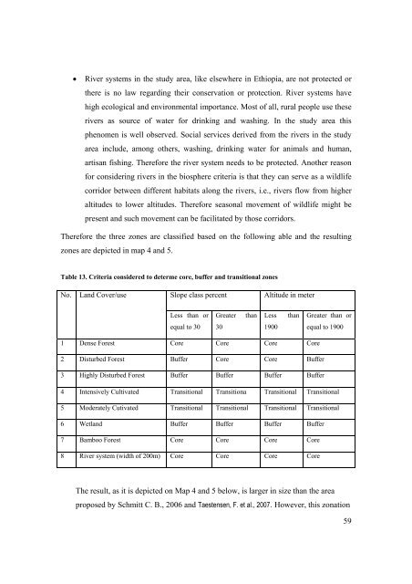
• River systems <strong>in</strong> the study area, like elsewhere <strong>in</strong> Ethiopia, are not protected or<br />
there is no law regard<strong>in</strong>g their conservation or protection. River systems have<br />
high ecological <strong>and</strong> environmental importance. Most of all, rural people use these<br />
rivers as source of water for dr<strong>in</strong>k<strong>in</strong>g <strong>and</strong> wash<strong>in</strong>g. In the study area this<br />
phenomen is well observed. Social services derived from the rivers <strong>in</strong> the study<br />
area <strong>in</strong>clude, among others, wash<strong>in</strong>g, dr<strong>in</strong>k<strong>in</strong>g water for animals <strong>and</strong> human,<br />
artisan fish<strong>in</strong>g. Therefore the river system needs to be protected. Another reason<br />
for consider<strong>in</strong>g rivers <strong>in</strong> the biosphere criteria is that they can serve as a wildlife<br />
corridor between different habitats along the rivers, i.e., rivers flow from higher<br />
altitudes to lower altitudes. Therefore seasonal movement of wildlife might be<br />
present <strong>and</strong> such movement can be facilitated by those corridors.<br />
Therefore the three zones are classified based on the follow<strong>in</strong>g able <strong>and</strong> the result<strong>in</strong>g<br />
zones are depicted <strong>in</strong> map 4 <strong>and</strong> 5.<br />
Table 13. Criteria considered to determe core, buffer <strong>and</strong> transitional zones<br />
No. L<strong>and</strong> Cover/use<br />
Slope class percent Altitude <strong>in</strong> meter<br />
Less than or<br />
equal to 30<br />
Greater than<br />
30<br />
Less than<br />
1900<br />
1 Dense <strong>Forest</strong> Core Core Core Core<br />
2 Disturbed <strong>Forest</strong> Buffer Core Core Buffer<br />
3 Highly Disturbed <strong>Forest</strong> Buffer Buffer Buffer Buffer<br />
Greater than or<br />
equal to 1900<br />
4 Intensively Cultivated Transitional Transitiona Transitional Transitional<br />
5 Moderately Cutivated Transitional Transitional Transitional Transitional<br />
6 Wetl<strong>and</strong> Buffer Buffer Buffer Buffer<br />
7 Bamboo <strong>Forest</strong> Core Core Core Core<br />
8 River system (width of 200m) Core Core Core Core<br />
The result, as it is depicted on Map 4 <strong>and</strong> 5 below, is larger <strong>in</strong> size than the area<br />
proposed by Schmitt C. B., 2006 <strong>and</strong> Taestensen, F. et al., 2007. However, this zonation<br />
59