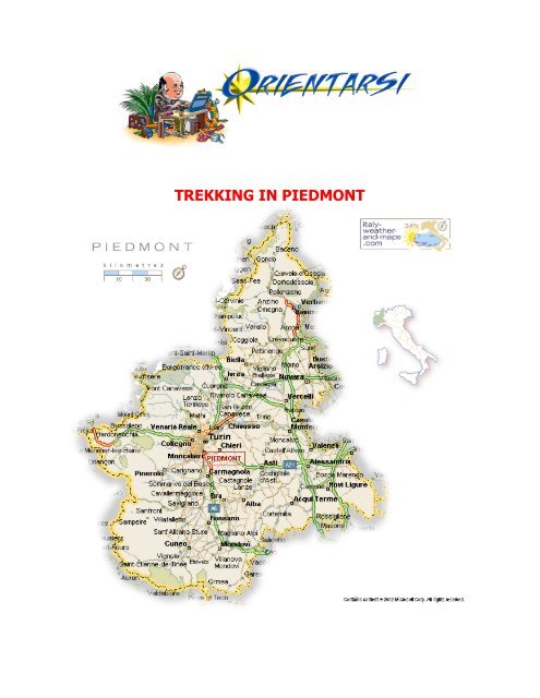
TREKKING IN PIEDMONT - Orientarsi
TREKKING IN PIEDMONT - Orientarsi
TREKKING IN PIEDMONT - Orientarsi

Create successful ePaper yourself
Turn your PDF publications into a flip-book with our unique Google optimized e-Paper software.
<strong>TREKK<strong>IN</strong>G</strong> <strong>IN</strong> <strong>PIEDMONT</strong>
La Grande Traversata del Biellese (Bi)<br />
This lengthy hiking route with its 234 km is one of Italy’s longest hikes provided with signals; it<br />
begins and ends at the Santuario di Oropa (sanctuary of Oropa) and is ring shaped. The Grande<br />
Traversata del Biellese (GTB – The Biella province Great Crossing) is made of 57 stages, with<br />
extremely varied levels of difficulty, crossing every setting the province offers: alternating<br />
embossments, woods and plains without ever reaching elevated altitudes. In fact, the route<br />
remains below 1000 m for the most part, touching its maximum altitude of 1250 m during the final<br />
stage along the Tracciolino, an ancient road that once united the principal sanctuaries of the Biella<br />
province. The GTB was conceived with the objective of building a route that could include the main<br />
naturalistic, artistic and devotional attractions of this area. This is why the departure and arrival<br />
points were chosen among those easy to reach from Biella by means of public transportation or<br />
among those with a nearby parking lot for automobiles. The 57 stages are clustered into 15 trails,<br />
each one of which ideally represents a one day hike that could eventually be broken down even<br />
more.<br />
Massif of the Rosa dei Banchi (To)<br />
A three stage hike through the upper Soana Valley to discover the landscape of the Canavese<br />
area.<br />
Stage 1: From the houses in Forzo, follow the path running along the bottom of the Vallone di<br />
Lavina, along the left mountain side, following back up in a north eastern direction into a rocky<br />
bowl. Once above the Alpe Costa, turn right, reaching Grange Lavina Grossa. Climb up a steep<br />
slope that leads to Colle della Cadrega. On the other side, follow a trail that diagonally crosses<br />
Torre di Lavina in a northern direction to then turn eastward for a descent into the Grange Rancio
di Sopra. At that point follow the left mountain side to reach the Grange di Aramant and from<br />
there the path continues on a dirt road leading to the Piano di Azaria and to the Campiglia Soana<br />
village.<br />
Stage 2: From Campiglia there is a climb up to Grange Cugnonà. Follow the mule track leading<br />
into a north eastern direction towards the pass found along the right side of the Monte Rosa dei<br />
Banchi. After Colle della Borra, the trail descends quickly, touching upon various granges arriving<br />
all the way to Grange Prariond, where it enters into a road ending at the hamlet of Piamprato.<br />
Stage 3: A mule track climbs from the houses in Alpe Giassetto and continues towards the dip<br />
that separates Monte Marzo from the Cima delle Chiose, the Bocchetta delle Oche. After crossing,<br />
follow the descent into a narrow valley, characterised by shelf-like slopes which initially lead to the<br />
hamlet of Tallorno and then to the inhabited area of Fondo.<br />
Urban Trekking in Ivrea (To)<br />
Urban hiking is the increasingly popular, innovative way to deepen one’s understanding of a city’s<br />
history and cultural heritage. Maps and mini guides accompany tourists and inquirers along a<br />
series of routes purposely realised to reveal hidden corners and to feel the more provocative<br />
places that have survived in modern cities. Ivrea, like other places in the Canavese area has<br />
studied an itinerary, circular in shape, that leads to a discovery of the marks different historic<br />
periods have left behind in its urban fabric. Ivrea is also synonymous of great industrial and<br />
occupational realities. Urban hiking offers a possibility of getting acquainted with the many<br />
buildings related to the entrepreneurial adventure of the Olivetti family and their “Fabbrica<br />
Nazionale Macchine per Scrivere” (National Typewriter Factory).The MAAM outdoor museum<br />
created to preserve the city’s Olivetti culture has also been dedicated to them.
Via Alpina in the Biella province - from<br />
Gressoney/Saint Jean to Piedicavallo (Bi)<br />
The itinerario blu (Blue route) of the Via Alpina – the alpine hiking route system connecting eight<br />
European countries – traces a journey that leads from the glaciers of Monte Rosa to the maritime<br />
Alps, and essentially follows the course of the Piemonte Alps. Two stages of the “via blu” (D17 – D<br />
18) cross the Biella area retracing the Walser population, the German speaking people who had<br />
settled in the Piemonte Alps after having migrated from the Swiss Valais canton. The path which<br />
originates from Gressoney Saint Jean in Val d’Aosta, passes ancient Walser villages and crosses<br />
over alpine pastures and forests of pine trees and broad leafed trees. After crossing the Lazouney<br />
and the Mologna Grande hills, there is a descent into the Rifugio Rivetti (Rivetti lodge) that can be<br />
used as a base for climbs into the Punta dei Tre Vescovi, to the Monte Rosso del Croso, to the<br />
Gemelli di Mologna and to Monte Cossarello. The route continues: descending to Piedicavallo. The<br />
next leg of the journey leaves from the town of Valle del Cervo, following the ancient commercial<br />
route that once led into the Aosta Valley by way of Colle della Vecchia.