

Geologic And Hydrologic Factors Governing ... - Gunnison County
Geologic And Hydrologic Factors Governing ... - Gunnison County
Geologic And Hydrologic Factors Governing ... - Gunnison County

You also want an ePaper? Increase the reach of your titles
YUMPU automatically turns print PDFs into web optimized ePapers that Google loves.
Jan<br />
Feb 4<br />
2<br />
3.4<br />
Mar<br />
3.5<br />
Apr<br />
2.4<br />
1.8<br />
May 3 2.8<br />
Jun<br />
2.5<br />
Jul<br />
0.8<br />
1.8<br />
Aug 2 2.7<br />
Sep 1.5<br />
Oct1.5 2.7<br />
Nov<br />
Dec<br />
1<br />
3.3<br />
1.4<br />
0.5<br />
Inches<br />
0<br />
<strong>Geologic</strong> <strong>And</strong> <strong>Hydrologic</strong> <strong>Factors</strong> <strong>Governing</strong> Impacts Of Development<br />
On The Crystal River Near Marble, Colorado<br />
<strong>Gunnison</strong> <strong>County</strong>, Colorado<br />
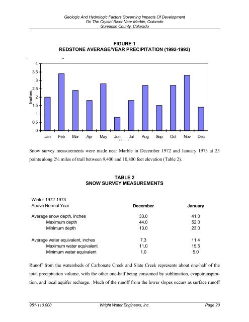
FIGURE 1<br />
REDSTONE AVERAGE/YEAR PRECIPITATION (1992-1993)<br />
Jan Feb Mar Apr May Jun Jul Aug Sep Oct Nov Dec<br />
M th<br />
Snow survey measurements were made near Marble in December 1972 and January 1973 at 25<br />
points along 2¼ miles of trail between 9,400 and 10,800 feet elevation (Table 2).<br />
Winter 1972-1973<br />
Above Normal Year<br />
TABLE 2<br />
SNOW SURVEY MEASUREMENTS<br />
December<br />
January<br />
Average snow depth, inches 33.0 41.0<br />
Maximum depth 44.0 52.0<br />
Minimum depth 13.0 23.0<br />
Average water equivalent, inches 7.3 11.4<br />
Maximum water equivalent 11.0 15.5<br />
Minimum water equivalent 1.0 5.0<br />
Runoff from the watersheds of Carbonate Creek and Slate Creek represents about one-half of the<br />
total precipitation volume, with the other one-half being consumed by sublimation, evapotranspira-<br />
tion, and local aquifer recharge. Much of the runoff from the lower slopes occurs as surface runoff<br />
951-110.000 Wright Water Engineers, Inc. Page 20
