

Geologic And Hydrologic Factors Governing ... - Gunnison County
Geologic And Hydrologic Factors Governing ... - Gunnison County
Geologic And Hydrologic Factors Governing ... - Gunnison County

You also want an ePaper? Increase the reach of your titles
YUMPU automatically turns print PDFs into web optimized ePapers that Google loves.
<strong>Geologic</strong> <strong>And</strong> <strong>Hydrologic</strong> <strong>Factors</strong> <strong>Governing</strong> Impacts Of Development<br />
On The Crystal River Near Marble, Colorado<br />
<strong>Gunnison</strong> <strong>County</strong>, Colorado<br />
While a detailed hydrologic study usually addresses site specific discharge rates, sediment yield<br />
data, stream channel dimensions and other related field observations; this types of hydrologic study<br />
is beyond the scope of this investigation. To provide a hydrologic evaluation for this study, the<br />
measurement of regional drainage basin land surface features has been determined from U.S. Geo-<br />
logical Survey (USGS) topographic maps. The intent of this type of investigation is to deduce<br />
whether the Slate and Carbonate Creeks have obviously different stream geomorphologic character-<br />
istics or if similar process rates occur within all of the associated drainages. A total of 118 first order<br />
steams within the Crystal River drainage system were measured for six variables. Second-, third-,<br />
and forth-order stream segment data was also reviewed but not analyzed. Table 4 lists the basin ge-<br />
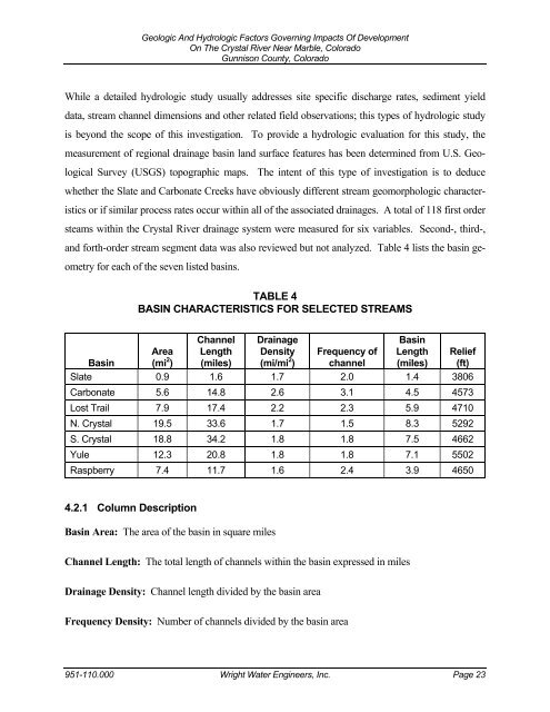
ometry for each of the seven listed basins.<br />
TABLE 4<br />
BASIN CHARACTERISTICS FOR SELECTED STREAMS<br />
Area<br />
Basin (mi 2 Channel Drainage<br />
Length Density<br />
) (miles) (mi/mi 2 Basin<br />
Frequency of Length Relief<br />
) channel (miles) (ft)<br />
Slate 0.9 1.6 1.7 2.0 1.4 3806<br />
Carbonate 5.6 14.8 2.6 3.1 4.5 4573<br />
Lost Trail 7.9 17.4 2.2 2.3 5.9 4710<br />
N. Crystal 19.5 33.6 1.7 1.5 8.3 5292<br />
S. Crystal 18.8 34.2 1.8 1.8 7.5 4662<br />
Yule 12.3 20.8 1.8 1.8 7.1 5502<br />
Raspberry 7.4 11.7 1.6 2.4 3.9 4650<br />
4.2.1 Column Description<br />
Basin Area: The area of the basin in square miles<br />
Channel Length: The total length of channels within the basin expressed in miles<br />
Drainage Density: Channel length divided by the basin area<br />
Frequency Density: Number of channels divided by the basin area<br />
951-110.000 Wright Water Engineers, Inc. Page 23
