SSG No 4 - Shipgaz
SSG No 4 - Shipgaz
SSG No 4 - Shipgaz

Create successful ePaper yourself
Turn your PDF publications into a flip-book with our unique Google optimized e-Paper software.
for accuracy rather than long-range forecasts<br />
to allow shipping to take precautions.<br />
Organizations such as the UK’s MET<br />
Office, the European Center for Medium-<br />
Range Weather Forecast (ECMWF), the US<br />
National Center for Environmental Prediction<br />
(NCEP), the US Navy’s Fleet Numerical<br />
Oceanographic Center (FNMOC) and<br />
even Japan’s JMA produce global weather<br />
forecasts for up to five days and beyond.<br />
<strong>No</strong>t all services are free of charge, but some<br />
are available on the Internet or on marine<br />
weather fax to shipping.<br />
Lose accuracy beyond 6–7 days<br />
Generally forecasts tend to lose accuracy<br />
beyond 6–7 days. But with today’s satellite<br />
communication every ship equipped with<br />
GMDSS (Global Maritime Distress & Safety<br />
System) can be reached instantly. Ships<br />
at sea can now download 10 days of wind<br />
and wave forecasts in a few minutes. In<br />
other words, the information is available,<br />
and much of it is free of charge.<br />
In 1988, the IMO amended the Safety<br />
of Life at Sea (SOLAS) Convention,<br />
requiring ships subject to it fit GMDSS<br />
equipment. Such ships were required to<br />
carry NAVTEX and satellite EPIRBs by<br />
August 1, 1993, and had to fit all other<br />
GMDSS equipment by February 1, 1999.<br />
US ships were allowed to fit GMDSS in<br />
lieu of Morse telegraphy equipment by the<br />
Telecommunications Act of 1996, according<br />
to the US Coast Guard.<br />
The GMDSS consists of several systems,<br />
some of which are new, but many of which<br />
have been in operation for many years.<br />
The system will be able to reliably perform<br />
the following functions: alerting (including<br />
position determination of the unit in distress),<br />
search and rescue coordination,<br />
locating (homing), maritime safety information<br />
broadcasts, general communications<br />
like weather forecasts, and bridge-to-<br />
bridge communications. Specific radio carriage<br />
requirements depend upon the ship’s<br />
area of operation, rather than its tonnage.<br />
The system also provides redundant means<br />
of distress alerting, and emergency sources<br />
of power.<br />
Therefore, there is no excuse for not taking<br />
the necessary precautions to avoid<br />
damage to ship and cargo. Believe it or not,<br />
seafarers ignore severe weather warnings all<br />
the time. As severe weather gets ever more<br />
violent, the attitude of many captains can<br />
have serious consequences, sometimes<br />
even with loss of life as a result. In this<br />
issue we talk of the “Zombies” of the<br />
Dover Strait, and elsewhere, we are pretty<br />
sure. They trundle up the lanes with their<br />
AIS turned off and, by the looks of it, are<br />
running on autopilot, apparently oblivious<br />
to the fact that they are in the busiest shipping<br />
lane in the world.<br />
Cats and dogs, sprats and turtles<br />
We all know the expression “raining cats<br />
and dogs”. But what if it rained fresh<br />
sprats? In a freak incident in August 2000 a<br />
shower of dead, but still fresh sprats rained<br />
down of the British fishing port of Great<br />
Yarmouth. It was caused by a small tornado,<br />
which trawled up water and anything<br />
in it and showered it on the small town.<br />
When the tornado reached land it lost its<br />
IT & COMMUNICATIONS<br />
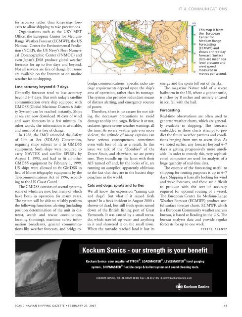
This map is from<br />
the European<br />
Center for<br />
Medium Range<br />
Forecasting<br />
(ECMWF) and<br />
shows a three-day<br />
forecast. Surface<br />
data are mean sea<br />
level pressure and<br />
wind speed<br />
measured in<br />
metres per second.<br />
energy and the sprats fell out of the sky.<br />
The magazine Nature told of a severe<br />
hailstorm in the US, where a gopher turtle,<br />
6 inches by 8 inches and entirely encased<br />
in ice, fell with the hail.<br />
Forecasting<br />
Real-time observations are often used to<br />
generate weather charts, which are generally<br />
available to shipping. The forecasts<br />
embedded in these charts attempt to predict<br />
the future weather patterns and conditions<br />
ranging from two to seven days. As<br />
we noted earlier, any forecast beyond 6–7<br />
days is getting progressively more unreliable.<br />
In order to remedy this, very sophisticated<br />
computers are used for analysis of a<br />
huge quantity of real-time data.<br />
The essence of the forecasting useful to<br />
shipping for routing purposes is up to 6–7<br />
days. Shipping is basically looking for wind<br />
and wave forecasts, and these are difficult<br />
to produce with the sort of accuracy<br />
required for optimal routing of a vessel.<br />
The European Center for Medium-Range<br />
Weather Forecast (ECMWF) produce useful<br />
surface forecast charts. ECMWF, which<br />
is a European Community weather analysis<br />
bureau, is based at Reading in the UK. The<br />
bureau analyses data and provide regular<br />
forecasts for up to one week.<br />
petter arentz<br />
Kockum Sonics - our strength is your benefit<br />
Kockum Sonics- your supplier of TYFON ® , LOADMASTER ® , LEVELMASTER ® level gauging<br />
system , SHIPMASTER ® flexible cargo & ballast system and sound cleaning tools.<br />
KOCKUM SONICS, Tel:+46 40 671 88 00, Fax: +46 40 21 65 13, www.kockumsonics.com<br />
SCANDINAVIAN SHIPPING GAZETTE • FEBRUARY 23, 2007 41