Water Well Manual (USAID).pdf - The Water, Sanitation and Hygiene
Water Well Manual (USAID).pdf - The Water, Sanitation and Hygiene
Water Well Manual (USAID).pdf - The Water, Sanitation and Hygiene

You also want an ePaper? Increase the reach of your titles
YUMPU automatically turns print PDFs into web optimized ePapers that Google loves.
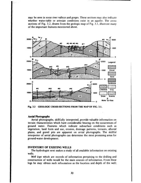
may be seen in some river valleys <strong>and</strong> gorges. <strong>The</strong>se sections may also indicate<br />
whether water-table or artesian conditions exist in an aquifer. <strong>The</strong> cross-<br />
sections of Fig. 3.2, drawn from the geologic map of Fig. 3.1, illustrate many<br />
of the important features mentioned above.<br />
Fig. 3.2 GEOLOGIC CROSSSECTIONS FROM THE MAP OF FIG. 3.1.<br />
<strong>Water</strong> surface<br />
Aerial Photographs<br />
Aerial photographs, skillfully interpreted, provide valuable information on<br />
terrain characteristics which have considerable bearing on the occurrences of<br />
ground water. Features which indicate subsurface conditions such as<br />
vegetation, l<strong>and</strong> form <strong>and</strong> use, erosion, drainage patterns, terraces, alluvial<br />
plains, <strong>and</strong> gravel pits are apparent on aerial photographs. <strong>The</strong> skillful<br />
interpreter of aerial photographs can determine the most promising areas for<br />
ground-water development.<br />
INVENTORY OF EXISTING WELLS<br />
<strong>The</strong> hydrologist next makes a study of all available information on existing<br />
wells.<br />
<strong>Well</strong> logs which are records of information pertaining to the drilling <strong>and</strong><br />
construction of wells would be the main sources of information. From these<br />
logs he may obtain such information as the location <strong>and</strong> depth of the well;<br />
30