

Final Conservation Plan - Kildare.ie
Final Conservation Plan - Kildare.ie
Final Conservation Plan - Kildare.ie

You also want an ePaper? Increase the reach of your titles
YUMPU automatically turns print PDFs into web optimized ePapers that Google loves.
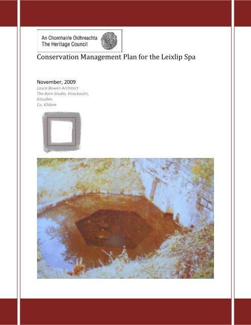
<strong>Conservation</strong> Management <strong>Plan</strong> for the Leixlip Spa<br />
November, 2009<br />
Laura Bowen Architect<br />
The Barn Studio, Knockaulin,<br />
Kilcullen.<br />
Co. <strong>Kildare</strong>
Contents<br />
1.0 Background.............................................................................. 1<br />
1.1 Introduction<br />
1.2 Scope<br />
1.3 Objective<br />
1.4 Consultation<br />
2.0 Understanding the Site..............................................................................2<br />
2.1 Short Description of the Place.<br />
2.2 Chronological developments and<br />
events in reference to Spa site.<br />
3.0 Assessment of the Significance of the site...............................11<br />
3.1 Statement of Significance<br />
3.2 Community Resource<br />
3.3 Social<br />
3.4 Education<br />
3.5 Sc<strong>ie</strong>ntific<br />
3.6 Aesthetic Values<br />
4.0 Identif<strong>ie</strong>d Vulnerabilit<strong>ie</strong>s and management issues.............. 17<br />
4.1 Condition of Fabric and setting<br />
4.2 Access<br />
4.3 Ownership and funding<br />
4.4 Existing Legal Framework for protection<br />
4.5 Proper Understanding and Knowledge of the place.<br />
5.0 <strong>Conservation</strong> polic<strong>ie</strong>s & their implementation .............................19<br />
5.1 Guiding Principle<br />
5.2 Summary of Relevant Legislation<br />
5.3 Specific Legislative Framework<br />
6.0 Implementation....................................................................... 33<br />
6.1 Summary<br />
6.2 Further Stud<strong>ie</strong>s<br />
6.3 Monitor the proposal for general access<br />
6.4 Modification of the draft recommendation<br />
on access, previously proposed.<br />
6.4 rev<strong>ie</strong>w<br />
Bibliography................................................................................. 35<br />
Appendix<br />
Map 1 Leixlip as Nodal point in Cultural Landscape<br />
Map 2. Features<br />
Map 3. Aspects<br />
Map 4. Areas of Change<br />
2 | P a g e
1.0 Background<br />
1.1 Introduction<br />
'This project was funded by the Heritage Council under the Local Heritage<br />
Grant Scheme 2009 under the auspices of KCC and LTC.' It is a continuation of the <strong>Conservation</strong><br />
Management <strong>Plan</strong> outline proposed as necessary by Nicki Matthews <strong>Conservation</strong> Architect. It<br />
seeks to address the future management of both sides of the valley which stretches from Louisa<br />
Bridge in the South, to the derelict canal house to the North. Map 1 in the Appendix shows the<br />
location of the site, the extent and the prominent features pertaining to this plan in 2009.<br />
1.2 Scope<br />
Previously the scope of the plan referred mainly to the Spa well and bath sites south of the River Rye<br />
and historically a number of specialist reports addressed this side of the site in more detail, for what<br />
was seen as the more sensitive SAC habitats. LTC had previously produced a framework plan for<br />
the both sides of the river in 2004 which proposed the idea of a park and the restoration of the Spa<br />
and Bath. Following this a conservation report for refurbishment of the Bath was completed from<br />
which it was proposed that a conservation management plan be produced to address all aspects of<br />
the site. In formulating the <strong>Conservation</strong> <strong>Plan</strong> all the stakeholders were interv<strong>ie</strong>wed. This process<br />
seeks to rev<strong>ie</strong>w all the specialist reports into the Ecology, Hydology and History and rev<strong>ie</strong>w the<br />
management of the site to date.<br />
1.3 Objectives<br />
This cultural landscape needs to be v<strong>ie</strong>wed as a collection of features which are a combination of<br />
natural semi-natural and man-made which collectively form the sense of place. Previous<br />
management decisions may not have fully appreciated the overall significance of the site or focused<br />
on some elements or aspects to the detriment of others. It is important to understand that this<br />
management plan is a mechanism for re-accessing previous decisions as well as the basis for<br />
future plans. This <strong>Conservation</strong> plan is not static and it and needs to be rev<strong>ie</strong>wed to manage any<br />
change in circumstance. At best it seeks to sift through the resonances that this site has for various<br />
groups and to ensure that these significances are understood, the main objective at the end of the<br />
process is to agree the polic<strong>ie</strong>s necessary to maintain the identif<strong>ie</strong>d significance of the site & safe<br />
guard its future by the following:<br />
Identifying threats to the site and setting<br />
Agreeing an approach to the ongoing conservation and fabric.<br />
Identifying areas where coordination of policy and action are needed<br />
1.4 Consultation<br />
Preparation of the plan involved consultation with individuals and organisations and was further<br />
commented when a draft plan was submitted by written submission by Denis McCarthy & John<br />
Colgan.<br />
June Eiffe, Spa committee member formerly on Taisce, Lisa Harlow Intel c/o, Sarah Sexton,<br />
Chairman of Fr<strong>ie</strong>nds of the Rye valley committee River, Nicki Matthews <strong>Conservation</strong> Architect, Niall<br />
Meagher former County Architect, John Colgan Tidy Towns Pro, Declan Doogue, Dublin Naturalists<br />
f<strong>ie</strong>ld Club, Bridget Loughlin Heritage Officer, Ciara Flynn National Parks and Wildlife, Val Swan<br />
District (Environment)<strong>Conservation</strong> officer, Denis McCarthy, Rye River Committee<br />
By Phone<br />
Peter Black <strong>Kildare</strong> County Council <strong>Conservation</strong> Officer, Bob Aldwell retired Principal Geologist,<br />
Practitioners<br />
Reports and surveys which were referred to and conclusions drawn from where prepared by the<br />
following practitioners.<br />
Dr. Pamela Bartley - Hydrologist<br />
Dr. Evelyn Moorkens - Environmental Consultant<br />
Melinda Lyons - Ecologist<br />
Nicki Matthews - <strong>Conservation</strong> Architect<br />
3 | P a g e
2.0 Understanding the Site<br />
2.1 Short description of Place<br />
The Spa site is located in a valley cleft where the Royal Canal aqueduct crosses the Rye River valley<br />
and is approximately two Km to the west of Leixlip. It is bounded to the south by the local R148<br />
Leixlip-Maynooth road. The site itself covers an area of 4.9 Acres, with its eastern boundary<br />
adjoining the Royal canal towpath and adjacent the Leixlip Train station (Louisa Bridge) which<br />
provides local and national rail services. This serves the commuting population of Leixlip and there<br />
is a large car parking area to the south of the R148.<br />
The Rye water as seen in Map 1 of the appendix runs from Carton in Maynooth towards Dublin in a<br />
linear North-west to East direction. The Royal canal with Linear Canal Park runs north-south to the<br />
eastern side of the site. To the West, on the southern side of the river, Intel Ireland has its<br />
manufacturing facility covering an area of 360 acres and over a mile long. The Intel sports grounds<br />
are immediately adjacent to the western boundary.<br />
The site south of the river contains the Spa well and Bath which are of historic importance linked<br />
by a manmade aqueduct which carr<strong>ie</strong>s the Royal Canal over the River Rye. The topography of the<br />
site is a ser<strong>ie</strong>s of stepped terraces towards the river. The entrance is through a hard standing area<br />
on the level of the towpath that in the past served as a car parking area. This was created in the<br />
1980`s to facilitate access to the site. Misuse of this car park led to the introduction of vehicular<br />
barr<strong>ie</strong>rs in early 1990`s. Today there is also a second barr<strong>ie</strong>r on the towpath limiting its use to<br />
pedestrians and banked earth and large stones defining the sites boundary to the towpath. Refer to<br />
Map 2 in the appendix for the sal<strong>ie</strong>nt features of the site. This first terrace below the entrance<br />
contains the two pond areas halfway between the well and the Bath which contain the Annex II plant<br />
spec<strong>ie</strong>s which is part of the special area of conservation (cSAC). The Bath occurs on the second<br />
terrace located centrally on axis with the waterfall on the northern side of the River. To the side of this<br />
terrace there is located the rare priority habitat i.e. petrifying spring with tufa formation (which is<br />
listed in Annex 1 of the EU habitats Directive). The Bath is accessed by the remains of a central<br />
path; part of measures that were installed in the 1980 s after the Bath was first discovered. Recent<br />
work to the site is the installation of a boardwalk to the northern side of the Rye Valley from the toll<br />
collector‟s house to the base of the waterfall and a v<strong>ie</strong>wing point on the aqueduct over the Rye<br />
Valley.<br />
2.2 Chronological developments and events in reference to Spa site.<br />
The discovery of a thermal spring when workmen were constructing the aqueduct for the Royal<br />
Canal and the sites linkage to Thomas Connolly and Louisa Lennox important local historical figures<br />
are outlined below, as well the background, to events relating to the site to present day.<br />
1758<br />
Louisa Lennox marr<strong>ie</strong>s Tom Conolly, who was living in England at the time. He is convinced by his<br />
brother in law the Earl of <strong>Kildare</strong> (later to become the Duke of Leinster) to take over his inherited<br />
estate Castletown which adjoined his own demesne, Carton. James Fitzgerald the Earl of <strong>Kildare</strong><br />
was marr<strong>ie</strong>d to Emily Lennox.<br />
1786<br />
The second Duke of Leinster and an adjoining landowner lobb<strong>ie</strong>d to have the planned route of the<br />
Royal Canal diverted around the southern boundary of their estates causing the expensive crossing<br />
of the River Rye by the aqueduct we see today. At the time the aqueduct was built it was claimed as<br />
being 5m higher than the bridge on the Clyde navigation in Scotland which claimed the title of<br />
greatest in the world. The Valley adjoining the aqueduct would have been modif<strong>ie</strong>d by quarrying to<br />
obtain the large amount of earth banking necessary. Thousands worked on the construction of an<br />
aqueduct – then the largest such project in Europe - to carry the canal across the river Rye at<br />
Collinstown, West Leixlip. The labour force camped locally while brought great economic benefits for<br />
the area.<br />
4 | P a g e
Louisa and Tom Connolly make a visit to Matlock 1 , a Spa in England. Louisa without disclosing her<br />
identity is greatly thrilled to meet other sections of soc<strong>ie</strong>ty.<br />
1791<br />
Aqueduct was started with .a huge workforce who was camped with in the area.<br />
1792<br />
Flooding damage to Aqueduct foundation means it has to be restarted again.<br />
1793<br />
Workmen discovered a spring during the digging out the Royal Canal and diverted it to a hexagonal<br />
basin alongside the canal, the same year the situation in France with the Napoleonic wars made it<br />
very difficult to access the continent for the “ Grand Tour “or visiting Spas and this type of<br />
recreational travel virtually ceased.<br />
1778-79<br />
Louisa Conolly built a Bathing house with portico at Castletown.<br />
1794<br />
This spring was diverted and a well installed so that passengers on the canal or in a carriage<br />
alongside on the tow path could draw a bucket of water without alighting from their carriage. At this<br />
time taking the “cure” from health-giving mineral waters was well established and it was bel<strong>ie</strong>ved<br />
that the “Volatile” nature of the water would be lost if bottled so most people preferred to travel to<br />
the waters to take them in situ or Bathe in them. It seems the Leixlip well attracted many people<br />
particularly the poor, and invalided.<br />
Public use of the Spa well begins in earnest. Thomas Connolly has the water tested from the well for<br />
its curative propert<strong>ie</strong>s.<br />
1796<br />
Aqueduct opened for canal traffic.<br />
1803<br />
The death of Thomas Connolly means the further development of the Spa Bath with Pump Room<br />
and Hotel which was planned was never proceeded with. It seems that it reputation may have been<br />
lost due to the exaggerated claims of its curative propert<strong>ie</strong>s as it popularity had declined.<br />
1815<br />
With the ending of the Napoleonic Wars, people begin to travel again to the continent to visit Spas,<br />
increasingly attracted on the basis of health. The benefit of the more elaborate Spa accommodation<br />
at Lucan led to it being more popular than Leixlip. Smaller, rural Spas fell out of favour both in<br />
Ireland and England during this time.<br />
1845<br />
155km of Royal Canal was sold to Midland and Great Western Railway Co. which in turn used the<br />
aqueduct embankment as a quick and easy way of constructing the rail line to Mullingar. This greatly<br />
improved the access to Leixlip.<br />
1848<br />
New railway station called Louisa Bridge and Leixlip opened on the East of the canal.<br />
1851<br />
Railway Station renamed Leixlip.<br />
1852<br />
Passenger Canal boats ceased despite attractive pricing, due to competition from the rail network.<br />
1885<br />
Construction of the Lucan, Leixlip and Celbridge steam Tramway<br />
1892 -1893<br />
Dublin Naturalists F<strong>ie</strong>ld Club visited the Chalybeate springs, the first record is made in Ireland of a<br />
particularly rare spec<strong>ie</strong>s of fungi (Uromyces Parnessiae) At this stage the Well and the Bath had<br />
fallen out of favour with the public and had been forgotten.<br />
1897<br />
1 Tillyard S. Aristocrats, Caroline, Emily. Louisa and Sarah Lennox 1740-1832 .pg 352<br />
5 | P a g e
Lucan, Leixlip and Celbridge steam Tramway ceased due to the low demand.<br />
1933<br />
A rare Snail was discovered in the lower flood plain.<br />
1946<br />
Population of nearby Leixlip had fallen to 467 from 1,358 in 1821<br />
1961<br />
The Royal Canal shut down to navigation, though official closure stated as April 6th 1966.<br />
1963<br />
Louisa Bridge Station closed to passengers, though the export of livestock still kept cattle on the<br />
trains and in the adjoining goods area.<br />
1960s<br />
Valley proposed as a possible dump location by a local businessman, saved by the addition of<br />
public car park at Louisa Bridge entrance, for CIE.<br />
1972<br />
An Foras ForBatha complete the first report indicating that the area south of the River Rye (including<br />
the Spa and fountain was an area of sc<strong>ie</strong>ntific interest. This was noted as an area of sc<strong>ie</strong>ntific<br />
interest because of the unusual and rare plants found in this unique environment provided by the<br />
springs and the temperature of the water.<br />
1972<br />
Use of the goods area alongside the railway station for livestock storage ceases, opening the way<br />
for its future use as a car park instead of the area adjoining the Spa.<br />
1974<br />
Restoration begins on the Royal Canal by volunteers who formed the Royal Canal Amenity group<br />
determine to ensure it would be navigable.<br />
1975<br />
European Architectural Heritage year the <strong>Kildare</strong> branch of An Taisce adopted the Spa Bath<br />
restoration as its project, scouts and the local youth club were enlisted to help. They dug out the<br />
Bath which had been bur<strong>ie</strong>d and redirected the water from the ponds towards the Bath, having<br />
unblocked the overflow. The Intention was that it be used as a paddling pool for local children.<br />
1976<br />
Report prepared by Niall Meagher, County Architect on “The History and Development of Leixlip<br />
Spa.”<br />
1978<br />
Brendan Dalt KCC Refers to the Spa and Bath as being listed for preservation in the County<br />
Development <strong>Plan</strong><br />
1979<br />
Property leased by CIE to <strong>Kildare</strong> County Council for use with conditions that it is used as<br />
an amenity area, with improvements to be carr<strong>ie</strong>d out on the Spa well and Bath and<br />
prevention of itinerant‟s encampments on the site. Spa and Bath restoration near complete.<br />
KCC begin installation of a trunk sewer in connection with the Regional Sewage scheme<br />
involving a sewer under the Royal Canal ( Note letter on file from June Eiffe noting that the<br />
work which caused the diversion of the overflow from the Spa well was causing the area in<br />
the immediate vicinity of the Bath to become flooded, she noted that this area was previously<br />
dry enough for the boy scouts to camp on.)<br />
An Foras Forbarha carr<strong>ie</strong>d out a commissioned study on plants.<br />
1980<br />
Note on KCC`S File to the effect that the box drain ( which suggested an C18TH stone culvert) from<br />
the Spa well had collapsed, and also a letter from the County Engineer to Eric Wallace KCC refers<br />
to using a new pipe to direct water rather than the existing box drain. It was noted that this pipe will<br />
discharge at a lower level then the former box drain, lowering the water level in the pond area. Levels<br />
6 | P a g e
were taken of site along the pipeline route, relative to Poolbeg Datum. An Foras ForBatha asked to<br />
discuss change in pipe with contractor.<br />
1980s<br />
Dredging of the river Rye and straightening of its line carr<strong>ie</strong>d out for fisher<strong>ie</strong>s purposes. This work<br />
causes change to the plant environment and natural flood plains along its edge.<br />
1981<br />
Louisa Railway Station opened again for passengers, creating a demand for car parking.<br />
1981<br />
The Leixlip Spa Amenity Scheme was established as part of an environmental trail linking features<br />
along the Royal Canal from Louisa Bridge. Recommendations made regarding parking facilit<strong>ie</strong>s.<br />
1981<br />
Proposal made by a local pitch and put club to lease the northern side of River Rye (adjoining<br />
waterfall) as a new pitch & putt course, turned down in favour of a conservation use such as nature<br />
trail.<br />
1983<br />
Works carr<strong>ie</strong>d out by KCC to landscape the site, to conserve the Bath and Spa well to stabilize the<br />
banks adjoining the Spa and bring a district drain for housing estates to the west across the car<br />
park. As part of these works a new boardwalk over the streams was established to the east of the<br />
Bath. Trees were planted on both sides of path down the middle level to which a gravel surface was<br />
installed and a v<strong>ie</strong>wing point above the Bath. The report refers to manhole between fountain and<br />
pond being cleaned out, and also the repair of the inlet pipe into the Bath. Tom Kennedy of the Irish<br />
Times wrote of “metal plates inserted as barr<strong>ie</strong>rs underground to spread the flow of water” and he<br />
also noted the importance of the existence of the Tufa petrifying spring. Mr. Kennedy (a noted<br />
ecologist) spoke of the Spa as being comparable to the “Thijisse Hof” in Holland (an instructional<br />
garden to show native plant spec<strong>ie</strong>s in a natural environment to schoolchildren). This was in contrast<br />
to KCC documentation of the time referring to “The Leixlip Spa Park” and extensive detailed<br />
drawings to install paths, steps and a pedestrian bridge across the river to the waterfall side.<br />
1984<br />
A Report by an Foras ForBatha describes the Bath as being in good condition, though<br />
vandalism was taking place at the weekends. Roger Goodwille of an Foras ForBatha noted<br />
“more recent work connecting the cleaning of the Bath and laying out part of the drain has<br />
resulted in water flow becoming more directed than formerly on the slope down to the river.”<br />
Letter from June Eiffe in an Taisce noted that area besides the Bath at eastern end upper<br />
terrace was now flooded when it was previously dry, and noted that the water had been<br />
diverted because of the main drain sewage works being carr<strong>ie</strong>d out by KKC.<br />
An Taisce suggest that they take up a lease on the Spa well site.<br />
Allocation made for footbridge linking the two sides of the valley under the environmental<br />
improvement scheme allocation<br />
Niall Meagher, County Architect & <strong>Plan</strong>ner, suggested the setting up a sc<strong>ie</strong>ntific Advisory<br />
service. Comprising of<br />
An Foras ForBatha<br />
An Taisce<br />
Dublin Naturalists` F<strong>ie</strong>ld Club<br />
National Museum<br />
Eastern Fisher<strong>ie</strong>s Board<br />
1985<br />
Maintenance works carr<strong>ie</strong>d out to Bath and well.<br />
Weed is cut to the east of the upper pond, the Bath is cleaned and the grass is cut around the park,<br />
the Spa well was cleaned out. The wire fence around the upper ponds was repaired. New gates<br />
were to be fixed in the open position. Picnic tables added to the car park area and nature trail<br />
markers.<br />
7 | P a g e
1985- late 1990s-2000<br />
Travellers‟ camp at the site and the KCC install an Armstong junction drain for the encampment on<br />
the car park. Considerable damage was caused during this period, to the brickwork on the Bath and<br />
granite surrounds were removed. Cider part<strong>ie</strong>s and rubbish caused blocking of the box drain by<br />
plastic bags to the Spa well. Gates were torn down and the trees damaged or uprooted<br />
1986<br />
Population of Leixlip increased dramatically from 2,402 in 1971 to 11,938 in 1986.<br />
Rye valley riding school asked not to ride through the area.<br />
Suggestion made to add a style to close off accessibility of riders and motorcycles<br />
Old Car wreck removed.<br />
Noted that the wet steps needed attention.<br />
It was noted that the flow of water to the East of the Bath needed to be directed.<br />
A suggestion was made that the toll collectors house be refurbished and put to use as a<br />
nature study centre<br />
1987<br />
Quote for works received for Leixlip Spa to avail of E.U funded amenity grant.<br />
The Irish Geological Survey of Ireland through Bob Aldwell asks for permission to bore in the<br />
Spa area to test geothermal potential.<br />
1989<br />
Intel establishes in Leixlip, the adjoining football pitch was bought by Intel from a local club as sports<br />
grounds for their staff. For a while it was thought that the installation of a ditch along the boundary<br />
caused the western side of the site to dry out. This was proved erroneous in recent Hydrological<br />
report prepared by Dr. Pamela Bartlett.<br />
Leixlip Town Council publishes Lēim Ar Aghaidh in a development programme for Leixlip which<br />
includes aim of balanced conservation & development of the Spa architecture and flora & fauna.<br />
1990<br />
Consideration was given by KCC to closing the lowest terrace south of the River Rye off to the<br />
public.<br />
1991<br />
It was decided by KCC to drop the pedestrian bridge over the river Rye as no contractors would<br />
respond due to the difficult<strong>ie</strong>s and restrictions on access.<br />
1991<br />
Leixlip Town Council publish information brochure on Spa, Canal, Aqueduct & Railway.<br />
1992<br />
Sewage works carr<strong>ie</strong>d out for health and safety reasons to Traveller‟s encampment.<br />
1994<br />
The Eastern Fisher<strong>ie</strong>s Board with funding from Intel start monitoring fish stocks in the River Rye in<br />
conjunction with UCD to rejuvenate Spawning beds and the banks of the river as far as the<br />
aqueduct. Beyond the aqueduct towards town centre the beds are enhanced to allow Spawning of<br />
trout and salmon and the river banks are cut back. Holes are formed in the bed to encourage<br />
whorls.<br />
1996<br />
Adoption of the Leixlip Spa site as an SAC area constituted part of the Rye valley/ Carton Estate<br />
Special Area of <strong>Conservation</strong> SAC 0011398) the priority habitat, petrifying springs with tufa<br />
Formation (7220) 9Annex 1, EU habitats Directive. This gives the backing of EU legislation to the<br />
NHA (Natural Heritage Areas) and ensures that the government undertakes the protection and<br />
monitoring of these fragile environments.<br />
Metal barr<strong>ie</strong>rs were erected at the entrance following vacation of site by travellers.<br />
2000<br />
New railway platforms and station built to connect to the existing Station now called Leixlip/Louisa<br />
Bridge.<br />
8 | P a g e
2003<br />
Due to lack of awareness of the Spa well and Bath the site was not recorded when the Record of<br />
Protected structures was formulated under the National Inventory of Architecture of Ireland (NIAH) it<br />
has since been added and is considered to be of national significance.<br />
The Leixlip Local Area <strong>Plan</strong> in 2003 adopted the Spa well and Roman Bath as protected structures<br />
along with the toll collectors house. This plan also added named protected v<strong>ie</strong>ws, from the<br />
aqueduct towards the waterfall and from the bridge. Omitted from this was the protection of the<br />
aspect from the Spa Bath towards the waterfall and the lock house.<br />
2004 March<br />
Report prepared by CAAS environmental services for Leixlip Town Council titled” Framework for the<br />
Future Use, Options for Leixlip Spa” was prepared. It proposes an extensive upgrade of existing<br />
paths network within the site and installation of a picnic area to the Louisa Bridge end with<br />
refurbishment of the Spa well and Bath.<br />
2005<br />
The Eastern Fisher<strong>ie</strong>s Board with funding from Intel win an international environmental prize for best<br />
documented river rejuvenation project in Europe.<br />
2007 May<br />
.Report by LTTA on new car park for 340 cars which had been opened to the South side of Louisa<br />
Bridge indicating that cars were no longer parking along the verge of the road.<br />
2007 July<br />
Survey for Vertigo Angusitor at Louisa Bridge, Co. <strong>Kildare</strong> (SAC 001398 Rye Water Valley Carton) by<br />
Dr. Evelyn Moorkens noted that it was not found in areas where it was previously located in this site.<br />
2007 Sept<br />
Vegetation map of the site commissioned by <strong>Kildare</strong> County Council carr<strong>ie</strong>d out.<br />
2007 Oct<br />
Report prepared by Nicki Matthews, <strong>Conservation</strong> Architect, on the conservation works to the Spa<br />
and Bath and the necessity of establishing a <strong>Conservation</strong> Management <strong>Plan</strong> for the overall site.<br />
Stage One of the <strong>Plan</strong> was carr<strong>ie</strong>d out which was to establish the historical & architectural<br />
significance of the Spa and well including the recommendation for a management plan and<br />
framework of polic<strong>ie</strong>s to be put in place for the overall site. It is also recommended that this site be<br />
put forward as a set p<strong>ie</strong>ce/ historic landscape under the new NIAH designation of gardens and<br />
planned landscapes. Comprising of all the built elements and terracing of the landscape to be<br />
v<strong>ie</strong>wed as a set p<strong>ie</strong>ce in tandem with its natural setting.<br />
2007 Nov<br />
John Colgan, Spa committee, Leixlip Tidy Town Association representative affirmed that the LTTA<br />
would aim to do a litter pick every six months. Bollards were reinstalled at entrance to prevent illegal<br />
parking.<br />
2007 Nov<br />
Proposal made by Earth route (environmental company) for the creation of paths through Intel to<br />
the edge of the Rye river / Spa site for recreation of their staff and wider community, this was later<br />
rejected as being too intrusive and a security risk to the Intel site.<br />
2007 July<br />
Water Ways Ireland agree with LTTA proposal to install v<strong>ie</strong>wing place overlooking Rye from<br />
Aqueduct and installation of interpretive panel on the canal towpath.<br />
2008 March<br />
Application for Part 8 appl<strong>ie</strong>d for works to the waterfall site to install a boardwalk or steps to the<br />
base.<br />
2008 April<br />
Level survey taken of the waterfall and Spa site by KCC including water levels.<br />
2008 Sept<br />
9 | P a g e
Report by Hydro- G on hydrogeology of the Spa site, and the tracing of the drains installed by KCC<br />
across the previous car park site. It is advised that if the site is to be re-engineered in any way that<br />
the sites hydrological characteristics when the groundwater levels recede i.e. (summer) require<br />
characterisation.<br />
2008 Nov<br />
Installation of a boardwalk to waterfall side of the site, Information boards on history at Louisa<br />
Bridge, at the toll collectors house and a new v<strong>ie</strong>wing platform is formed on the aqueduct looking<br />
over the Rye River. This was funded by Bōrd Failte and KCC with text & illustrations suppl<strong>ie</strong>d by<br />
John Colgan, local historian, for the LTTA and managed by Parks superintendant Simon Wallace,<br />
KCC.<br />
2008 Nov.<br />
Heritage Week; Visit to the site organized to raise public awareness.<br />
2009 February<br />
Report Leixlip Spa Management <strong>Plan</strong> produced as draft.<br />
A second report is produced by Melinda Lyons on the Louisa Bridge Waterfall Site Management<br />
<strong>Plan</strong>. First priority actions under this include scrub removal. Second and third priority actions are to<br />
be carr<strong>ie</strong>d out in 2009-2010 with the continued implementation of this plan over the next few years.<br />
2009 February<br />
Application was made by Siobhain Barry, Leixlip Town Clerk for a grant from the Heritage Council to<br />
enable the creation of a conservation management plan. Funding will not be forthcoming for grants<br />
from OPW, Foll<strong>ie</strong>s Trust or Heritage Council until a management plan is in place.<br />
2009 March<br />
Appropriate Assessment Screening of Leixlip local area <strong>Plan</strong> 2008 in line with the requirements of<br />
Article 6(3) of the EU Habitats Directive prepared by Golders Associates for KCC clarifying impact of<br />
the development plan and policy formation in relation to SAC areas.<br />
2009 May<br />
Laura Bowen was appointed by KCC to implement the remaining stages of the conservation plan,<br />
prepared by Nicki Matthews starting with consultations with all the stakeholders of the site.<br />
2009 June July<br />
Face to face meetings were held with most attendees of the Leixlip Spa Committee for Interim<br />
Report to KCC in Mid July with a Draft <strong>Conservation</strong> <strong>Plan</strong> for consultation with members and KCC by<br />
the end of August.<br />
2009 July 27th<br />
Interim meeting held with Simon Wallace of KCC to report on progress.<br />
2009 August 6th<br />
Site visit made with Des O Leary, Architectural Department KCC in attempt to locate manhole or<br />
drain run.<br />
10 | P a g e
3.0 Assessment of the significance of the site.<br />
3.1 Statement of significance<br />
This site is a highly significant heritage site in many areas. In a European context the Spa well is a<br />
rare example of a mineralised thermal spring which gives rise to unique habitats of flora and fauna. It<br />
is among the top five petrifying Tufa springs in Ireland and aspects of its ecology and fauna put it<br />
as a priority one under the European designation as an SAC, whose rarity and fragility need<br />
protection.<br />
In its wider cultural sense it forms part of the larger c18 th landscape which is still intact in this part of<br />
<strong>Kildare</strong> particularly along the Rye and Liffey river valleys. Its strong association by location and<br />
culture with the historical figures of Louisa and Thomas Connolly around which there is good<br />
information provide the basis for relating this location with the nearby demesnes. At present the<br />
idea that a landscape should be protected is a growing area of study and is recognized by the<br />
setting up of the new survey recording designed landscapes and gardens by the National Inventory<br />
for Architectural Heritage (NIAH). Architecturally there are no other examples of a thermal Bath of<br />
this type in Ireland.<br />
3.2 Community Resource:<br />
The Leixlip Spa site l<strong>ie</strong>s on a number of terraces carved in limestone bedrock, this bedrock was<br />
quarr<strong>ie</strong>d to supply building material for adjoining houses, further excavation was necessary when<br />
the construction of the canal aqueduct began which is effectively a large embankment over a single<br />
bore tunnel, over 100ft above the river Rye beneath. This may have created the terraces visible<br />
today.<br />
When the thermal spring was discovered under the canal route by workmen in the 1790s they<br />
diverted it to a constructed hexagonal basin adjoining the towpath to form the Spa well. The<br />
hexagonal perimeter surrounding this has a grooved channel going in a north westerly direction<br />
towards an oval brick lined Roman Bath with symmetrical steps at both ends. The Bath was formerly<br />
fed by warm water. The Bath was set on a lower terrace formed by the construction of the aqueduct<br />
and was has been located to take advantage of v<strong>ie</strong>ws over the River Rye, of the waterfall (canal<br />
overflow) to the north, the aqueduct and the lock house or the other points of interest. The backdrop<br />
to the whole set p<strong>ie</strong>ce was the tree shrouded slopes of Mount Thunder to the north. There were<br />
facilit<strong>ie</strong>s provided at the Spa well adjoining the canal to allow water to be brought up to the higher<br />
level by a bucket so that passengers in a coach on the towpath could take the waters without<br />
alighting. Passengers on the canal were also facilitated by this feature of the well. It appears that the<br />
Spa well and Bath had good use for at least 20 years though then gradually fell into decline and then<br />
out of use. By the end of the 19 th century the use of Bath and Spa had been abandoned and<br />
forgotten, and the site was given over to cattle grazing.<br />
The Spa Bath and basin were rediscovered in the 1970s by scouts who at the time camped on the<br />
site and community groups proposed the use of the Bath as a local paddling pool for the small<br />
children in the area. In 1975 the European Heritage year the refurbishment of the Bath and well was<br />
adopted by an Taisce and funding was obtained. In 1980s work was undertaken to the Bath, with<br />
some labour such as the digging out carr<strong>ie</strong>d out by the local youth group and the scouts. Technical<br />
advice and contracting work such as consolidation and brickwork were funded by KCC and An<br />
Taisce and the Bath were envisaged as an amenity for locals. This refurbishment work was originally<br />
to the area south of the River Rye, the Spa site in general was developed as a park which was to be<br />
linked as part of a nature route between Maynooth and Leixlip. During the late eight<strong>ie</strong>s very little use<br />
was made of the park and it became a neglected area vandalised by a disaffected youths which<br />
was further compounded by the establishment of a traveller‟s encampment in the previous CIE car<br />
park located adjoining Louisa Bridge. However the amenity use of this site in the more recent times<br />
11 | P a g e
has become more significant in the minds of the local community with the growth in population in<br />
Leixlip and increased urbanization.<br />
The adjoining canal and railway connections and the sites close proximity to the town with<br />
the established walking trail on the canal towpath means that the Spa and waterfall site are again<br />
accessed by the community. The recent development of the boardwalk and v<strong>ie</strong>wing platform<br />
adjoining the waterfall have giving new access to base of the waterfall on the northern side of the<br />
River the access to this will need to be monitored to ensure this now doesn‟t attract groups. While<br />
the heritage of the Spa well itself may not be apparent to the new residents/ locals the site has<br />
become important to Leixlip as a rural retreat.<br />
Shorthand<br />
Always accessible by the public and the Spa was seen as a public resource to the<br />
Community since its very beginning.<br />
Inextricably linked to the development of the Royal Canal and its use.<br />
Link to the ideas of c18 th cultural & planned landscape of Castletown & Carton House<br />
3.3 Social:<br />
There is great social significance in the fact that the major landowners and power brokers had<br />
established their country estates along the banks of the Liffey and its tributary in close proximity to<br />
Dublin, the seat of parliament. These powerful individuals left their impression on the surrounding<br />
landscape by a cluster of large landholdings and demesnes and designed landscapes within the<br />
area. There was a degree of rivalry for patronage of the landlords for their tenants to demonstrate<br />
their status and impose or express their aesthetics on their environment.<br />
Tom Conolly was a member of the Commons and the major landowner in Leixlip when the spring<br />
was discovered upon his lands. Thomas Conolly`s wife, Louisa Augusta Lennox, was sister to Lady<br />
Emily Mary Lennox, who marr<strong>ie</strong>d to the Earl of <strong>Kildare</strong>. He later became (in 1776) the 1 St Duke of<br />
Leinster. In 1758 Louisa marr<strong>ie</strong>d Thomas Conolly, of Castletown, County <strong>Kildare</strong>, becoming Louisa<br />
Conolly. Louisa and her sisters Emily and Caroline were highly educated, bilingual in English and<br />
French and widely travelled both were totally au fait with the prevailing fashions of the continent as<br />
well as having a well connected pedigree to the highest levels of English soc<strong>ie</strong>ty.<br />
The erection of the aqueduct and the route modifications to the Royal Canal in this location<br />
were influenced by the second Duke of Leinster who was on the board of the New Royal Canal<br />
Company. He was a brother-in- law to Thomas Conolly. The Duke wished to re route the Royal<br />
Canal around his estate in Maynooth to allow a deep water harbour to the edge of his estate at<br />
Maynooth and bring the canal adjoining his leased estates thus obtaining higher lease values from<br />
his tenants who would have valuable transport links for disposing of their produce. This route<br />
necessitated the use of an aqueduct over the River Rye. There was an enormous cost to<br />
establishing this new canal route involving thousands of workers and at the time was one of the<br />
biggest constructional projects in Europe. The proximity to the existing Grand Canal rather than the<br />
more northerly alternative route meant that the two canal routes effectively starved each other of<br />
business. Due to the more expensive constructional aspects, the Royal Canal Company became<br />
economically unviable from the start and had to subsist with injections of government money. That a<br />
vested interest by a few men could influence the route of a major p<strong>ie</strong>ce of infrastructure is testament<br />
to the social fabric of the soc<strong>ie</strong>ty at the time. The coming of the Great Western railway made use of<br />
the already built aqueduct as part of the new line which was bought out from the failing Canal<br />
Company ensuring two major systems of infrastructure passed through Leixlip.<br />
Historically the development of a Spa had significance for a cross section of classes. Most<br />
Landlords looked to develop their estates and the establishment of a Spa well and Bath for public<br />
use ensured a steady stream of overnight stays and trade in the locality. Although the Spa itself<br />
didn‟t become a commercial venture due to the death of Thomas Conolly (who d<strong>ie</strong>d without an heir),<br />
he appears to have had plans for a pump room and hotel before his death. Many landlords of the<br />
12 | P a g e
period particularly in England derived additional income such as the bottling of Spa water. The fact<br />
that the Spa Bath remained undeveloped and accessible to all sectors of soc<strong>ie</strong>ty meant that the<br />
lower social classes made good use of the Leixlip Bath. In contrast the sulphur springs in Lucan<br />
were seen as more fashionable destination and had associated and purpose built entertainment and<br />
accommodation provided.<br />
The visiting of Spas allowed for mixing of social classes and became very popular in time as a new<br />
forum for social interaction between an emerging middle class and labouring class. With the<br />
development of the Lucan Spa with Hotel and Pump room the use of the external bath in its rural<br />
location fell out of favour. Samuel Lewis publication of the Topographical Dictionary of Ireland gave<br />
a description of Leixlip in 1837 he describes it popularity in the past tense noting “a chalybeate<br />
spring of great strength and purity, which was in high repute towards the close of the last century”.<br />
He also notes that the spring was a half a mile from the centre of the town which he describes as<br />
one street with some of the houses in neglect. There was a great rivalry between the Spas of Lucan<br />
and Leixlip at the turn of the 19 th century, with Lucan Sulphur Spa attracting crowds by holding<br />
concerts and dances in the locality. The Lucan Spa too was located a half a mile from Lucan town<br />
though nearer to the travelling public and eventually won out when accommodation such as “The<br />
Crescent” was built as lodging houses, erected for the accommodation of those visiting the Spa.<br />
Travel by passenger barges ceased in the mid c19 th when they were replaced by train access. In<br />
time, the use of the Spa Bath in Leixlip became forgotten and hidden from memory. 2 The site was<br />
used by local farmers for grazing until the early 1970s. The area of the site nearest Louisa Bridge<br />
was in the ownership of CIE and used as a public car park until taken over by a traveller‟s<br />
encampment this meant that the rediscovered Bath site in particular was subject to antisocial<br />
behaviour such as on-going graffiti and fires.<br />
3.4 Educational<br />
The site is of great historical & social importance; its importance today as a heritage site is<br />
more of a part of an amenity of the Royal Canal rather than as a development in its own<br />
right. There seems to be a consensus that there is no push to redevelop its use for spring<br />
water or Bathing, rather to maintain it as a symbol of that past enterprise.<br />
The origins of this cultural landscape are set in the past and reflect both the structure and<br />
the social pursuits of the soc<strong>ie</strong>t<strong>ie</strong>s and who worked and lived in c18 th . It demonstrates the<br />
role of the c18 TH landowners as patron, improving the estates by the installation of the canal/<br />
Spa Bath. This resource was discovered by the community through the scouts & youths and<br />
recognized as being a finite resource.<br />
As part of their social interaction with the community, Intel the biggest manufacturer in the Country is<br />
disposed towards highlighting this neighbouring resource for educational purposes. They currently<br />
bring school trips to the area adjoining their own site but wish to include the historic and ecological<br />
importance of the Spa site. It was noted by an ecologist that this site had the potential to become an<br />
important educational ecological site similar to the “Thissije Hof” in Holland. This is an area in<br />
Holland that is used to educate school children in the form of a natural park, to demonstrate native<br />
plants and habitats in a naturally occurring habitat.<br />
2 Newspaper Article in Freemans Journal (1763-1924) published on Monday July 28, 1924<br />
13 | P a g e
3.5 Sc<strong>ie</strong>ntific<br />
The site was well known as a place of sc<strong>ie</strong>ntific interest from the earl<strong>ie</strong>st times. Its earl<strong>ie</strong>st use as a<br />
quarry and as material for the aqueduct meant that bedrock became exposed or brought nearer the<br />
surface. The Spa well lays on a fault line the importance of this which was known to the Irish<br />
geologists from a very early date. The fault line which aligns itself along the Lucan Celbridge towards<br />
West Meath and as far as Enf<strong>ie</strong>ld contains a number of hot springs. These springs are generally<br />
associated with very deep faults and or synclines and the water associated with them is of an older<br />
water age.<br />
The term Spa originates from the Latin 'Salus per Aqua' which means 'health through water', Spas<br />
and Bath were a legacy from the Romans had been very popular in mainland Europe for recreation,<br />
Bathing and the waters curative propert<strong>ie</strong>s. There was also a tradition in Ireland from druidic times in<br />
which pagan scared wells and springs always associated with healing and deit<strong>ie</strong>s, and were<br />
rebranded as holy wells from which cures could be sought. The rituals associated with the Bathing<br />
were accommodated by a patrons day such as that held at St. Bridget‟s. Well. These Patron days<br />
were where festivals and socializing would occur, though these days gradually became more formal<br />
and Christianised there was a strong tradition of both the spring/ wells curative propert<strong>ie</strong>s and as a<br />
recreational meeting place. By the early c18th the medical profession began to espouse the benefits<br />
of drinking mineral water as well as the more inconven<strong>ie</strong>nt bathing and noted a long list of diseases<br />
suitable for cure by these methods. There is very little information on Spas in Ireland at the time but<br />
the situation in England informed the fashion of the development of Spas. By the early c18 th in her<br />
book “Baths and Spas in England 1560-1815” the author Phyllis May Hembry noted there were very<br />
few bathing spas in England as most dealt with drinking water. Some medical practitioners bel<strong>ie</strong>ved<br />
that a cold spring bath generally up to the neck was much health<strong>ie</strong>r than a warm spring. Towards<br />
the end of the century the year round season of indoor Spas began to take hold; the benefits of<br />
finding a spring particularly a highly mineralized „warm‟ spring could bring travellers‟ willing to spend<br />
money to stay the night in the locality, thus bringing a stimulus to the local economy. To a landowner<br />
of the time it was important to get the water tested by sc<strong>ie</strong>ntific method or endorsed by a medical<br />
practitioner to ensure its popularity, and perhaps in Ireland`s case to distinguish the curative<br />
propert<strong>ie</strong>s of the water from what was thought to be pagan or popish superstition. This is probably<br />
why Thomas/ Louisa Conolly wishing to develop the discovery of the thermal spring had it tested to<br />
determine whether it had any health giving propert<strong>ie</strong>s.<br />
Extract taken from the Dublin Penny Journal in 1837 written by Terence O'Toole. 3<br />
Just beneath the bridge that carr<strong>ie</strong>s the road over the canal, is one of the most beautiful and abundant<br />
spring wells in Ireland - if it was known in old times it would have been sanctif<strong>ie</strong>d, as most such are in<br />
Ireland - but it burst out for the first time from the depths of the earth on the excavation of the canal; and<br />
as it was discovered in winter, and as its deep seated source caused it to appear warmer than other more<br />
superficial springs, so, immediately there were attributed to it virtues of no ordinary degree, and the<br />
crowds that in faith (for the Irish are rich in that cardinal virtue,) resorted to it were enormous. While the<br />
credulity lasted, the harvest of coach and noddy owners (for jaunting-cars were not yet in fashion,) was<br />
3 O'Toole was the nom-de-plume or alias of the Rev Caesar Otway, one time Church of Ireland curate of Leixlip, who<br />
lived in Newtown House, Leixlip. Taken from research provided by John Colgan in preparation for his second volume on<br />
the history of Leixlip town.<br />
14 | P a g e
immense strings of carriages, miles long, might be seen on Sundays issuing from Dublin, containing crowds<br />
anxious to apply, internally ,or externally, its healing waters; and attestations of its curing the blind<br />
- restoring the pals<strong>ie</strong>d - strengthening the lame, came before the public every day. But alas, the powers of<br />
ridicule were brought to bear against it, and one wicked wight drew a caricature in which he represented a<br />
broken down noddy as washed by the Leixlip Spa water, and all its spokes and shafts, under the mopping of<br />
the jarvey, becoming strong and strait. This certainly was a pity; and no one in the world was served by<br />
dissipating such an innocent and salutary delusion, and after all it is not only a beautiful but an<br />
extraordinary spring; for if you bel<strong>ie</strong>ve all the neighbours, not a fish or frog will live in its waters; and<br />
though there is a floculent, rusty-coloured, ochreous matter constantly rising to the surface of the well,<br />
exactly similar to that which is found in spring's strongly impregnated with iron, yet no test, either gallic<br />
acid or prussiate of potash, can detect any iron; but in the centre of this floculent matter is found a very red<br />
little worm about half en inch long, which all those who have still faith in the salubrity of the well say is the<br />
sovereignest remedy alive for a sore leg: nay more, let anyone who has drank over night from 15 to 20<br />
tumblers of punch, and whose head is so hot that it makes the water fizz into which it is put, let him but take<br />
a quart or two of the water of this spring on the following morning, and he will lose all his whiskey fever<br />
and walk home as cool as a cucumber. I assure you, gentle reader, I have seen sundry making the<br />
experiment, and I actually saw them afterwards sober.<br />
A number of thermal springs were known to geologists in this area however this spring at Leixlip<br />
was known to contain the most mineralized water being described historically as chalybeate or iron<br />
rich. The mixture of temperature and mineralization coupled with the excavated areas exposing the<br />
bedrock close to the surface in turn facilitated the development of unique habitats. It was this which<br />
attracted the Dublin Naturalist f<strong>ie</strong>ld club and was referred to in their newsletter in 1895 long after the<br />
use of the Bath and the spring had been forgotten. The site constitutes part of the River Rye Valley<br />
Special Area of <strong>Conservation</strong> (SAC) containing protected habitats including calcareous grasslands<br />
and petrifying Tufa springs, including rare and protected spec<strong>ie</strong>s of fauna including molluscs‟<br />
spec<strong>ie</strong>s; Vertigo Moulinsiana and Vertigo Angustior. Any works such as the installation of Paths ,<br />
Walls within the SAC including maintenance requires it to be notif<strong>ie</strong>d to the Minister through the<br />
NWPS.<br />
The earl<strong>ie</strong>st legal definition for protection of the Leixlip Spa as an area of sc<strong>ie</strong>ntific interest was by an<br />
Foras Forbathas which noted its plant life and spring as being of sc<strong>ie</strong>ntific interest and included this<br />
area as an extension of the River Rye from Carton. This area then became transposed into a Natural<br />
Heritage Area, and subsequently a “proposed special area of conservation”. Under this designated<br />
protection the spec<strong>ie</strong>s and habitats are listed and given a priority of protection, this European based<br />
legislation requires the site to be monitored by the government to ensure that the health of the<br />
habitats are being maintained with reports given on a six yearly basis 4 . The location of the adjoining<br />
Intel factory which under its own licensing is required to monitor water levels and water quality<br />
testing means that there is a lot of information available on the adjoining hydrology of the site. The<br />
preparation and commissioning of reports on the hydrology, ecology and heritage by KCC means<br />
that the site is recognized as a complex and significant site because of all these competing values.<br />
3.6 Aesthetic Values<br />
Located in a valley or cleft to the West of Leixlip this areas contains a confluence of a number of<br />
significant landscape features, the number of architectural features such as the aqueduct, the toll<br />
collectors house, the roman Bath and Spa and the canal overflow were planned to take full<br />
4 http://www.npws.<strong>ie</strong>/en/PublicationsLiterature/<strong>Conservation</strong>StatusReport/<br />
Link to recent report on the status of the site, next report in 2013<br />
15 | P a g e
advantage of the natural features of the site. The sense of progression through the site has to be<br />
imagined from the perspective of the main approach by the visitor which arrived by canal or road.<br />
The well was positioned tucked alongside the toll path but accessible from above. The positioning of<br />
the Bath along a central pathway to v<strong>ie</strong>w them on a lower terrace took full advantage of the terracing<br />
and v<strong>ie</strong>ws of the aqueduct and waterfall/ canal overflow directly opposite. The site itself is<br />
supplemented by the River Rye valley and the linear park of the Royal Canal and its towpath, all<br />
located in what is a small area. The proximity of this site to edges of Leixlip housing estates to the<br />
east and adjoining the Intel site, one of the largest Industrial sites in Ireland means that the sense of<br />
rural in the place is more pronounced and a complete surprise in what appears to be on the modern<br />
road approach in a very busy area, contrasted of course if you were to travel by canal. In particular<br />
the topography of the site means that sounds are contained within the valley including the sound of<br />
the waterfall from the canal overflow and visitors are struck by the qu<strong>ie</strong>tness in which the sound of<br />
insects and water predominant. Inland Waterways Ireland have established the Royal Canal as a<br />
linear park. The tow path is elevated on the aqueduct above the site, and has picnic tables installed<br />
along the bank. The recent installation of the new v<strong>ie</strong>wing platform to the centre of the Aqueduct<br />
embankment means that there is now a new vista to the west over the River Rye valley which shows<br />
the sheer scale of the rear of the Intel factory which is spread over 350 acres and is over one mile in<br />
length and gives a powerful counterpoint of new technology / industry adjoining a natural setting.<br />
16 | P a g e
4.0 Identif<strong>ie</strong>d Vulnerabilit<strong>ie</strong>s- Management Issues<br />
The order in which these items are addressed is not a reflection of their importance as each is<br />
significant in its own way.<br />
4.1 Condition of Fabric and setting<br />
At present the site at the entrance in particular with the banked earth and measures to stop<br />
vehicles entering including metal barr<strong>ie</strong>rs and ESB poles is not visually inviting.<br />
The deterioration of the fabric due to anti–social behaviour facilitated by the isolated nature<br />
of the sites topography in particular this has been characterised by drinking part<strong>ie</strong>s<br />
adjoining the Roman Bath.<br />
The site enjoys considerable legal protection under the SAC, which essentially limits<br />
interventions only to those necessary to maintain the site, it also contains plants and<br />
animals that are also of sc<strong>ie</strong>ntific significance and enjoy further legal protection. Any works<br />
that do take place should maintain or improve the ecological status of the site.<br />
Any works including maintenance to structures will need a declaration because of protected<br />
nature as well as an assessment on the effect on the ecology which the works are<br />
undertaken.<br />
4.2 Access<br />
The site is at this point in time is accessed by people walking their dogs or groups of<br />
youths. With the main through fare being on the canal towpath above and adjoining the site<br />
which has become a popular walking route.<br />
The pedestrian linkage across the site means that there is desire line route at present<br />
directly alongside the Bath, which comes through a very steep and slippery path across an<br />
old boardwalk, so that anyone coming along the central path can be suddenly faced with a<br />
youth and a dog, in an area that is not overlooked.<br />
Proximity to the adjoining urban area and increasing population growth means that there is<br />
an appetite to exper<strong>ie</strong>nce the rural feel of this location.<br />
The conflict arising between the need to protect the fabric of the architectural heritage and<br />
the application of health and safety measures for a fully assessable site means that any<br />
measures appl<strong>ie</strong>d to the site are in keeping with its significance and historical mil<strong>ie</strong>u.<br />
The Health and Safety aspects of standing water.<br />
4.3 Ownership and funding<br />
There is a complexity of the ownership and interests within the site and outside the site<br />
along its boundary.<br />
There is a strong involvement by the community over time. There is a desire for the public to<br />
access this area as a park or have the ability to go down to the river. This situation has<br />
diminished in part in response to the antisocial gathering which has deterred its use as a<br />
park. While this remains; the site does not look like it is being maintained or within<br />
ownership.<br />
That the sources for funding may determine the order of work or the type of work.<br />
Sources to date have been a combination of capital funding and grants through KCC<br />
heritage grants LTC, Bord Failte as well as help with the maintenance through volunteer<br />
groups, local residents committees or Leixlip Tidy town committee.<br />
4.4 Existing Legal Framework for protection<br />
Responsibilit<strong>ie</strong>s under the protected structures legislation means there is a requirement to<br />
conserve the significance and fabric of the built heritage. Any changes required to meet<br />
legal obligations cannot detract from the character or its setting within the landscape.<br />
17 | P a g e
Any works including maintenance to structures will need a declaration because of protected<br />
nature as well as an assessment on the effects to the ecology.<br />
Any works to fabric of the built heritage will need a high standard of expertise, materials and<br />
workmanship and the input of a conservation architect.<br />
There is an obligation to prevent further decay of the fabric and in the case of the collectors<br />
house this is an immediate necessity.<br />
The setting has survived to a remarkable degree but it is vulnerable to visual disruption from<br />
poorly sited development outside the boundar<strong>ie</strong>s of the site, such as masts, ESB lines, or<br />
inappropriately placed houses. The vista within the site is also important such as the v<strong>ie</strong>w<br />
from the Bath to the Waterfall and the toll collector‟s cottage.<br />
4.5 Proper Understanding and Knowledge of the place.<br />
There is a general lack of knowledge on the part of the public of the designed landscape,<br />
the significance of the Hydology of the area giving rise to unique habitats and the site<br />
history. Coherent information on the site is lacking.<br />
Rarity of the conditions for the Habitats.<br />
The Hydrology of the site is key to several significant aspects.<br />
18 | P a g e
19 | P a g e
20 | P a g e
21 | P a g e
22 | P a g e
23 | P a g e
24 | P a g e
25 | P a g e
26 | P a g e
27 | P a g e
28 | P a g e
29 | P a g e
30 | P a g e
31 | P a g e
32 | P a g e
6.0 Implementation<br />
6.1 Summary<br />
This sites location and vistas allows the linking together of the two major demesnes, Castletown and<br />
Carton to Leixlip which to have been cut off from their hinterland by the recent motorway. The site in<br />
the future could be a valuable resource to develop a cultural tourism point around the historical<br />
figures and landscape within the area. The site is ideally situated by the Canal Linear Park and<br />
adjoining transport links to move the centre of interest in this landscape back towards it. The<br />
adjoining uses of the lands whether or not within the ownership of KCC needs to be rev<strong>ie</strong>wed as<br />
changes in ownership occur. The Spa is a complex site, and that complexity is due to significance in<br />
a number of rare habitats and features. The hydrology of the site is integral to it, but the<br />
management of the natural processes on the site is at present causing the change in the ecology<br />
not the change in water flow as previously understood.<br />
6.2 Further Stud<strong>ie</strong>s<br />
To form a complete understanding of the Hydrology a study needs to be completed over a<br />
longer period and gaps within the plan in relation to Flora and Fauna information rev<strong>ie</strong>wed. The<br />
hydrology report commissioned indicated a fundamental change in the environment occurred in the<br />
past due the diversion of the c18th stone culvert, while recommending that the operation of this<br />
drain remain the same, the culvert needs to be investigated to confirm this understanding of the<br />
working of the Spa and to unblock the drain to lower the water to its original level.<br />
6.3 Monitor the proposal for general access<br />
The access to the site was proposed in a different way- as managed or directed access in<br />
order to limit the introduction of works within the site including protection measures adjoining the<br />
more sensitive areas of the site. It can be seen in the past that the site at one stage was thought of<br />
as a general amenity. In the locality the site is v<strong>ie</strong>wed as a valuable resource in what now has<br />
become a built up area, and the engagement within the community and among the members of the<br />
Spa committee has shown the commitment to the area‟s protection over decades. This sense of<br />
ownership needs to be continued.<br />
The polic<strong>ie</strong>s proposed for access to the site were developed to emphasize the shift<br />
towards the Canal tow path as the amenity from which the site was v<strong>ie</strong>wed and which it is presently<br />
set up to be, rather than have two competing amenit<strong>ie</strong>s side by side. Information for the site is to be<br />
tailored to be discreet within the landscape. Likewise the existing central path to be restored but in<br />
as far as possible to avoid the introduction of further handrails steps or barr<strong>ie</strong>rs required on the eastwest<br />
cross route. It is very important that the Spa well and Bath within the site can be seen from the<br />
towpath and their significance is interpreted by appropriate information.<br />
6.4 Modification of the draft recommendation on access, previously proposed.<br />
The Spa Committee rejected a proposal to have a managed access policy to the site with gated<br />
stone boundary wall at the entrance. The general consensus was that despite the new v<strong>ie</strong>wing<br />
platforms proposed from the canal towpath that the general public access would be curtailed from<br />
v<strong>ie</strong>wing the Bath at close quarters. This was also on the premise that the previous removal of historic<br />
fabric was facilitated by an unauthorized caravan encampment and vehicle access, which had now<br />
been dealt with by the use of metal height barr<strong>ie</strong>rs. It is recommended that the principle of defining<br />
the boundary (which could be a hedge or fence) at the entrance be accepted, as a way of defining<br />
the more sensitive nature of the site. This entrance Space can then be used to inform the public of<br />
access protocols to the site, as the implications of Health and Safety proposals to anc<strong>ie</strong>nt historic<br />
structures need to be implemented appropriately.<br />
It is also recommended that the order of the refurbishment works to the built heritage are modif<strong>ie</strong>d<br />
so that the more intact fabric of the Spa well is not exposed until the work to the Bath and<br />
33 | P a g e
overlooking v<strong>ie</strong>wing platform is completed and its fabric condition monitored over a period of one<br />
year.<br />
The ordering given in terms of priority of actions may need to be rev<strong>ie</strong>wed as some of the actions<br />
are dependent on volunteer work or on a timescale related to weather, (i,e. use of lime) or growing<br />
season.<br />
6.5 Rev<strong>ie</strong>w<br />
A periodic rev<strong>ie</strong>w needs to be carr<strong>ie</strong>d out of the <strong>Conservation</strong> <strong>Plan</strong>.<br />
The structural stability of the Toll collector‟s house is probably the first order of priority. The timing of<br />
the rest of the works may be curtailed by the new economic climate and this will need to be<br />
rev<strong>ie</strong>wed annually. The raising of the awareness of the significance of the site through a seminar or<br />
launch day could be in tandem with the entrance area though should if possible incorporate the<br />
refurbishment of the Bath and v<strong>ie</strong>wing platform.<br />
34 | P a g e
BIBLIOGRAPHY<br />
Matthews, N. (2007) <strong>Conservation</strong> <strong>Plan</strong> and Schedule of Works for Roman Bath Unpublished report<br />
for <strong>Kildare</strong> County Council<br />
Meagher, N. (1976) Canaliana<br />
Caas (2004): Framework for Future Use Options for Leixlip Spa, Co. <strong>Kildare</strong>. Unpublished report to<br />
Leixlip Town Council<br />
Hydro-G (2008): Hydrological report for Leixlip Spa, Co. <strong>Kildare</strong>. Unpublished report to <strong>Kildare</strong> Co.<br />
Council.<br />
Lyons (2009): Leixlip Spa Vegetation Map. Unpublished report to <strong>Kildare</strong> Co. Council.<br />
Moorkens, E. (2007): Survey for Vertigo Angustior at Louisa Bridge, Co. <strong>Kildare</strong>. Unpublished report<br />
to <strong>Kildare</strong> Co. Council.<br />
Lyons, M.( 2009) Louisa Bridge Waterfall Site Management <strong>Plan</strong>.<br />
Other Sources<br />
Vegetation Survey Map and Level Survey prepared by <strong>Kildare</strong> County Council.<br />
Tillyard S. Aristocrats, Caroline, Emily. Louisa and Sarah Lennox 1740-1832.<br />
Phyllis May Hembry The English Spa- a social history 1560-1815.<br />
<strong>Kildare</strong> County Council Files and correspondence 1974- 2009<br />
Finola O'Kane Landscape Design in Eighteenth-Century Ireland: Mixing Foreign Trees with the<br />
Natives Cork University Press, 2004<br />
Taylor Map 1783<br />
Towards a Liffey Valley Park: The Office of Public Works, in association with Dublin City Council<br />
and Fingal, <strong>Kildare</strong> and South Dublin County Councils, commissioned ERM to draw up a strategy<br />
for the Liffey Valley. The report, Towards a Liffey Valley Park was published in November 2006<br />
and it is being considered by the implementing authorit<strong>ie</strong>s concerned.<br />
http://www.kildare.<strong>ie</strong>/CountyCouncil/LeisureServices/LiffeyPark/<br />
35 | P a g e


