download here
download here
download here

Create successful ePaper yourself
Turn your PDF publications into a flip-book with our unique Google optimized e-Paper software.
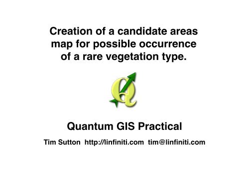
Creation of a candidate areas<br />
map for possible occurrence<br />
of a rare vegetation type.<br />
Quantum GIS Practical<br />
Tim Sutton http://linfiniti.com tim@linfiniti.com
Problem Statement<br />
You are tasked with finding areas in and around the Cape Peninsula that are a suitable habitat<br />
for a rare fynbos plant species. The extent of your area of investigation in the Cape Peninsula<br />
is : south of Melkbosstrand, west of Strand.<br />
Botanists have provided you with the following preferences exhibited by the species in question:<br />
- It grows on east facing slopes.<br />
- It grows on slopes with a gradient between 15% and 60%.<br />
- It grows in areas that have a total annual rainfall of > 1200 mm.<br />
- It will only be fund at least 250 m away from any human settlement.<br />
- The area of vegetation in which it occurs should be at least 6000m2<br />
As a volunteer for Cape Nature, you have agreed to search for the plant on the closest suitable<br />
piece of land to your house. Use your GIS skills to determine w<strong>here</strong> you should go to look.
Due Date: Friday 13 May 2011 at 17h00<br />
Your Task<br />
What to hand in:<br />
- A work log (document) that describes sequentially the process you followed w<strong>here</strong> each<br />
step is annotated to show the specific QGIS tool and tool options you used.<br />
- a shapefile containing the areas you identified to be suitable habitat<br />
- a shapefile containing the site from which you computed distances (e.g. your house)<br />
- a comma separated values (CSV) text file containing the distance matrix between your<br />
origin site and the suitable habitat areas.<br />
- an image file containing the map layout which should include the following elements:<br />
- a hill shaded terrain model<br />
- a false colour semi-transparent overlay of your resampled rainfall layer<br />
- streets presented with suitable symbology for the scale of your map<br />
- the site from which you computed distances annotated with a suitable icon and label<br />
(e.g. your house)<br />
- the areas you computed to be suitable habitat, with the closest one to you highlighted and<br />
indicated on the map using an arrow (as per example at the end of this document).<br />
Note: The entire exercise must be completed using QGIS (version 1.7 or better).<br />
Note: This is a practical assignment to be completed by each student individually.
Some Hints and Tips<br />
Set your project projection to EPSG:32733 (UTM Zone 33 South), and save / convert all of your<br />
datasets into this projection.<br />
The DEM is provided in LO19 - which is not a commonly used projection outside of South Africa<br />
and does not have an EPSG authority code. When converting that layer to UTM33S, make sure<br />
to specify the source CRS explicitly by selecting it from the user defined CRS list.<br />
Use % for slope steepness.<br />
When dealing with large datasets, first remove any features you don't need and clip the dataset<br />
to your AOI.<br />
The rasterise tool needs at least one numerical attribute before it will run - use the calculator tool<br />
on your table to create a new column and populate it appropriately.<br />
When dissolving features, look for the 'dissolve all' option in the drop down list.<br />
When working with rasters, e.g. your rainfall dataset, resample them to a common area and<br />
pixel dimensions for optimal results.<br />
Create a mask layer (1 inside the mask, nodata outside the mask) and multiply your rasters by<br />
the mask to remove any irrelevant data from the dataset.<br />
If you get stuck, try to approach the problem from a different angle - t<strong>here</strong> is usually more than<br />
one way to do it.<br />
Sometimes things take a little while to compute, just be patient.
DEM<br />
Clipped DEM<br />
Yearly Avg<br />
Rainfall Layer<br />
Generalised Zoning<br />
Warp to<br />
EPSG:32733<br />
Compute Slope<br />
Steepness<br />
Compute Slope<br />
Aspect<br />
Compute<br />
Hillshade for<br />
Visualisation<br />
Warp to<br />
EPSG:37733<br />
Digitise Bounding<br />
Box Layer (AOI)<br />
Extract Rural<br />
into new layer<br />
Workflow Overview Part 1<br />
Clip to Strand/<br />
Melkbos<br />
No<br />
East Facing?<br />
Yes<br />
Clip to Stand/<br />
Melkbos<br />
Dissolve<br />
Assign 0<br />
>45 && < 135<br />
Assign 1<br />
Resample<br />
Clip to AOI<br />
Initial Data Preparation<br />
No<br />
Slope > 15' and<br />
less then 60'?<br />
250m<br />
Yes<br />
Negative Buffer<br />
No<br />
Rainfall ><br />
1200mm?<br />
Yes<br />
Assign 0<br />
Assign 1<br />
Assign 0<br />
Not 200 as<br />
written in<br />
assignment!<br />
Assign 1<br />
Rasterize
Slope Steepness<br />
Candidate Areas<br />
Discard<br />
Compute Final Candidate Areas<br />
Rainfall Candidate<br />
Areas<br />
No<br />
Cross Product<br />
Map<br />
Vectorise<br />
Area size ><br />
6000m2?<br />
Final Candidate<br />
Areas<br />
Workflow Overview Part 2<br />
Slope Direction<br />
Candidate Areas<br />
Yes<br />
Rural Area<br />
Candidates<br />
Keep<br />
Calculate Closest Candidate to your House<br />
My House<br />
Make sure to<br />
create unique id<br />
columns for<br />
both!!<br />
Distance<br />
Matrix<br />
Analysis<br />
matrix.csv<br />
Final Candidate<br />
Areas<br />
Compute<br />
Centroids
Used Input Layers:<br />
DEM - CMA Dem (raster)<br />
GMAP - Yearly Rainfall (raster)<br />
Generailse Zoning Dissolve (vector)<br />
Street Names (vector)<br />
Example Results<br />
Created Output Layers:<br />
shade.tif - shaded relief model (raster)<br />
candidate-rainfall (raster)<br />
candidate-slopes (raster)<br />
east-slopes (raster)<br />
aoi (poly)<br />
rural-buffer (raster)<br />
final candidates (vector)<br />
candidate-centroids (vector)<br />
myhouse (vector)<br />
matrix (csv)<br />
InputID,TargetID,Distance<br />
1,1,7357.27169753<br />
2,1,7834.86228204<br />
3,1,7639.67826118<br />
4,1,6907.82017995<br />
5,1,7672.92174477<br />
6,1,10107.8244511<br />
7,1,10223.9673274<br />
8,1,9975.87899658<br />
9,1,6595.79008429<br />
10,1,7220.24749253<br />
11,1,6688.61990682<br />
12,1,6875.5651428<br />
13,1,6178.38582957<br />
14,1,6286.65277004<br />
15,1,8530.91339767<br />
16,1,8686.69407627<br />
17,1,8353.71172243<br />
18,1,8371.36534275<br />
19,1,9003.24871874<br />
20,1,8410.83156015<br />
21,1,9236.64811674<br />
22,1,8784.03231925<br />
23,1,8427.89226257<br />
24,1,9140.29032564<br />
25,1,8759.32539398<br />
26,1,8488.55454044<br />
27,1,8513.56695278<br />
28,1,8507.80933615<br />
29,1,8535.50191814<br />
30,1,8496.38863229
Workbook Example<br />
Step 1: Preparation<br />
- create a new blank QGIS project<br />
- click the icon in bottom right of the status bar<br />
- set the project coordinate reference system to EPSG:32733 (UTM33S)<br />
- save the project : File -> Save Project<br />
Step 2: Reproject DEM from LO19 to UTM33S<br />
- load the DEM : Layer -> Add Raster Layer -> CT/DEM/cct_10m/prj.adf<br />
- enable gdal tools plugin : Plugins -> Manage plugins -> Filter : gdal -> tick & press OK<br />
- warp the layer : Ensure Prj layer is selected then, Raster -> Warp -> Use the following options:<br />
- Input file : prf<br />
- output file : select and give the filename as dem.tif in a personal working directory<br />
- source srs : override the default 4326 : press select, select from user defined<br />
coordinate reference systems the one created for the dem (it will have +lon_0=19) in its text<br />
- target srs : set the output SRS : EPSG:32733(UTM33S) by selecting it from the select dialog<br />
- tick the 'load into canvas when finished' option and click OK<br />
- Remove the Prj layer : Layer -> Remove Layer<br />
- Zoom to the extent of the dem layer : View -> Zoom to Layer<br />
Step 3: ......and so on..........