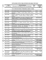
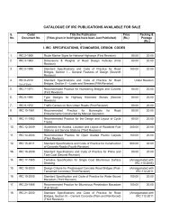
Highway Research Record No. 39 - Indian Roads Congress
Highway Research Record No. 39 - Indian Roads Congress
Highway Research Record No. 39 - Indian Roads Congress

You also want an ePaper? Increase the reach of your titles
YUMPU automatically turns print PDFs into web optimized ePapers that Google loves.
Further information/Copy of report can be obtained<br />
from<br />
The Head, Geotechnical Engg. Division, CSIR- Central<br />
Road <strong>Research</strong> Institute, New Delhi - 110025, Mobile:<br />
9868858380 phone: 26832173 Fax: 011-26845943,<br />
e-mail ID: vittal.crri@gmail.com<br />
3.<br />
Site Stabilisation for Platform at Diglipur<br />
(<strong>No</strong>rth Andaman)<br />
Keywords: landslide Stabilisation, Debris, Hill<br />
Cutting<br />
Date of Start: Feb 2012<br />
Date of Completion (Targeted): Dec. 2012<br />
I.<br />
II.<br />
Military Engineering Services( MES) (S)<br />
Central Road <strong>Research</strong> Institute, New Delhi<br />
(R)<br />
Scope and Objectives<br />
Stabilisation of Hill-Cut Slope at <strong>No</strong>rth Andaman Island<br />
(Near Diglipur) using appropriate landslide remediation<br />
measure<br />
Methodology<br />
The area under the study falls in the <strong>No</strong>rthern Part of<br />
Andaman Islands. Diglipur is the main township of the<br />
<strong>No</strong>rth Andaman Island, which is about 325 km from<br />
Port Blair. Most of the hill ranges in these islands,<br />
show a parallel trend to each other. The Platform was<br />
constructed after cutting two adjoining hillocks. The<br />
hilltop is at an elevation of 148m from mean sea level.<br />
The terrain is fully covered with dense vegetation.<br />
Nearly 3.5 lakhs cubic meters of earth was excavated<br />
to create platforms on the hilltop. Debris excavated from<br />
that area was loosely dumped on side slopes. Berms<br />
were provided on the slope. These hill cut platforms<br />
now face instability problems due to landslides. Heavy<br />
rainfall during monsoon contributes to slope stability<br />
problems in this area. The first landslide was observed in<br />
one side of the hill cut platform during September 2008.<br />
Presently another slide has occurred in the opposite<br />
side of the first slide. MES authorities requested CRRI<br />
to investigate and suggest Slope Stabilisation and<br />
other remedial measures. The field investigations are<br />
in progress.<br />
Interim Conclusions/Conclusions/Supporting Data<br />
The project is presently under progress.<br />
Significance/ Utilisation Potential<br />
The instability problems have occurred mainly due to<br />
(a) Highly weathered and soft nature of rocks in the<br />
ROAD RESEARCH IN INDIA 2011-12 33<br />
area and (b) Creation of additional overburden pressure<br />
due to dumping of hill cut materials (c) High rainfall and<br />
inadequate drainage measures which saturate the<br />
landmass<br />
Further information/Copy of report can be obtained<br />
from<br />
address: The Head, Geotechnical Engg. Division,<br />
CSIR- Central Road <strong>Research</strong> Institute, New Delhi<br />
- 110025, Mobile: 9868858380 phone: 26832173,<br />
Fax: 011-26845943, e-mail ID: vittal.crri@gmail.com<br />
4.<br />
Geotechnical Study of Jugsalai Cinder Dump<br />
Area for Construction Purposes<br />
I.<br />
II.<br />
Keywords: Cinder dump, SPT,DCPT and Plate<br />
load tests<br />
Date of Start: March 2011<br />
Date of Completion (Targeted): Dec. 2012<br />
Tata steel limited, Jamshedpur, Jharkhand<br />
( S)<br />
CSIR- Central Road <strong>Research</strong> Institute,<br />
New Delhi (R)<br />
Scope and Objectives<br />
•<br />
•<br />
Determining Feasibility for using cinder dump site<br />
for construction purposes<br />
Determining the type of foundations to be adopted<br />
for structures built on cinder dump<br />
Methodology<br />
Cinder is a waste material of coal burning residue<br />
from blast furnaces/ power plants. Slag is another<br />
waste material generated as a by-product during the<br />
manufacturing of iron. At Jamshedpur, both cinder and<br />
slag have been dumped together in the form of a dump.<br />
The slope of the mound is around 45 0 and the height<br />
is varying from 10 m to 45 m. Tata Steel works now<br />
intend to use this dump area to build structures and<br />
connecting roads on this dump. Sub-soil investigation<br />
was carried out at this dump area and different field tests<br />
viz. SPT, DCPT and Plate load tests were conducted.<br />
Data analysis work is in progress.<br />
Interim Conclusions/ Supporting Data<br />
The project is presently under progress.<br />
Further information/Copy of report can be obtained<br />
from<br />
address: The Head, Geotechnical Engg. Division,<br />
CSIR- Central Road <strong>Research</strong> Institute, New Delhi -<br />
110025, Mobile: 9868858380, phone: 26832173, Fax:<br />
011-26845943, e-mail ID: vittal.crri@gmail.com