Investigating Correlations between Snowmelt and Forest Fires in a ...
Investigating Correlations between Snowmelt and Forest Fires in a ...
Investigating Correlations between Snowmelt and Forest Fires in a ...

Create successful ePaper yourself
Turn your PDF publications into a flip-book with our unique Google optimized e-Paper software.
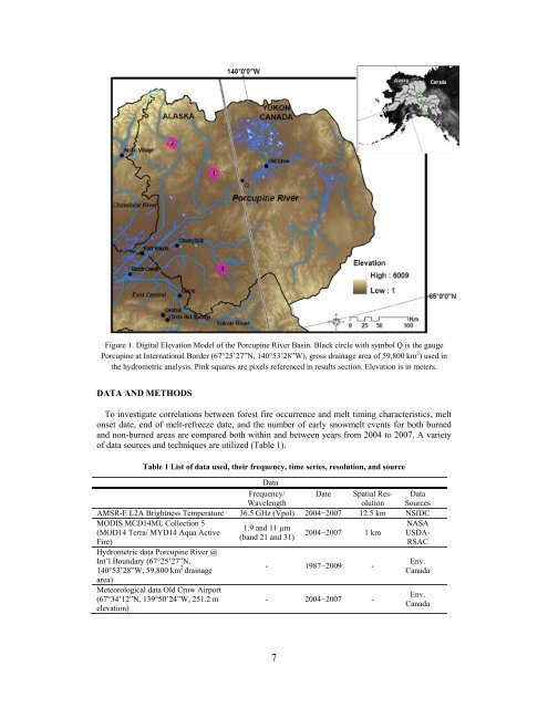
Figure 1. Digital Elevation Model of the Porcup<strong>in</strong>e River Bas<strong>in</strong>. Black circle with symbol Q is the gauge<br />
Porcup<strong>in</strong>e at International Border (67°25’27”N, 140°53’28”W), gross dra<strong>in</strong>age area of 59,800 km 2 ) used <strong>in</strong><br />
the hydrometric analysis. P<strong>in</strong>k squares are pixels referenced <strong>in</strong> results section. Elevation is <strong>in</strong> meters.<br />
DATA AND METHODS<br />
To <strong>in</strong>vestigate correlations <strong>between</strong> forest fire occurrence <strong>and</strong> melt tim<strong>in</strong>g characteristics, melt<br />
onset date, end of melt-refreeze date, <strong>and</strong> the number of early snowmelt events for both burned<br />
<strong>and</strong> non-burned areas are compared both with<strong>in</strong> <strong>and</strong> <strong>between</strong> years from 2004 to 2007. A variety<br />
of data sources <strong>and</strong> techniques are utilized (Table 1).<br />
Table 1 List of data used, their frequency, time series, resolution, <strong>and</strong> source<br />
Data<br />
Frequency/ Date Spatial Res- Data<br />
Wavelength<br />
olution Sources<br />
AMSR-E L2A Brightness Temperature 36.5 GHz (Vpol) 2004−2007 12.5 km NSIDC<br />
MODIS MCD14ML Collection 5<br />
(MOD14 Terra/ MYD14 Aqua Active<br />
Fire)<br />
Hydrometric data Porcup<strong>in</strong>e River @<br />
1.9 <strong>and</strong> 11 µm<br />
(b<strong>and</strong> 21 <strong>and</strong> 31)<br />
2004−2007 1 km<br />
NASA<br />
USDA-<br />
RSAC<br />
Int’l Boundary (67°25’27”N,<br />
140°53’28”W, 59,800 km 2 dra<strong>in</strong>age<br />
area)<br />
- 1987−2009 -<br />
Env.<br />
Canada<br />
Meteorological data Old Crow Airport<br />
(67°34’12”N, 139°50’24”W, 251.2 m<br />
elevation)<br />
- 2004−2007 -<br />
Env.<br />
Canada<br />
7