The FORE-SCE model: Land Use Modeling ... - Farm Foundation
The FORE-SCE model: Land Use Modeling ... - Farm Foundation
The FORE-SCE model: Land Use Modeling ... - Farm Foundation

You also want an ePaper? Increase the reach of your titles
YUMPU automatically turns print PDFs into web optimized ePapers that Google loves.
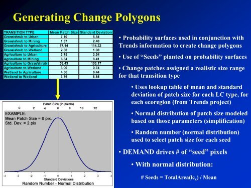
Generating Change Polygons<br />
TRANSITION TYPE Mean Patch Size Standard Deviation<br />
Grass/shrub to Urban 7.10 5.84<br />
Grass/shrub to Mining 1.37 2.40<br />
Grass/shrub to Agriculture 57.14 114.22<br />
Grass/shrub to Wetland 2.88 1.08<br />
Agriculture to Urban 3.75 3.54<br />
Agriculture to Mining 6.84 8.41<br />
Agriculture to Grass/shrub 58.43 103.17<br />
Agriculture to Wetland 3.00 0.74<br />
Wetland to Agriculture 4.36 6.44<br />
Wetland to Wetland 3.76 8.85<br />
USGS EROS Data Center<br />
• Probability surfaces used in conjunction with<br />
Trends information to create change polygons<br />
• <strong>Use</strong> of “Seeds” planted on probability surfaces<br />
• Change patches assigned a realistic size range<br />
for that transition type<br />
• <strong>Use</strong>s lookup table of mean and standard<br />
deviation of patch size for each LC type, for<br />
each ecoregion (from Trends project)<br />
• Normal distribution of patch size <strong>model</strong>ed<br />
based on those parameters (simplification)<br />
• Random number (normal distribution)<br />
used to select patch size for each seed<br />
• DEMAND drives # of “seed” pixels<br />
• With normal distribution:<br />
# Seeds = TotalArea(lc x ) / Mean