The FORE-SCE model: Land Use Modeling ... - Farm Foundation
The FORE-SCE model: Land Use Modeling ... - Farm Foundation
The FORE-SCE model: Land Use Modeling ... - Farm Foundation

Create successful ePaper yourself
Turn your PDF publications into a flip-book with our unique Google optimized e-Paper software.
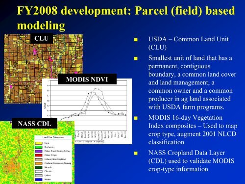
FY2008 development: Parcel (field) based<br />
<strong>model</strong>ing<br />
CLU<br />
NASS CDL<br />
USGS EROS Data Center<br />
MODIS NDVI<br />
USDA – Common <strong>Land</strong> Unit<br />
(CLU)<br />
Smallest unit of land that has a<br />
permanent, contiguous<br />
boundary, a common land cover<br />
and land management, a<br />
common owner and a common<br />
producer in ag land associated<br />
with USDA farm programs.<br />
MODIS 16-day Vegetation<br />
Index composites – <strong>Use</strong>d to map<br />
crop type, augment 2001 NLCD<br />
classification<br />
NASS Cropland Data Layer<br />
(CDL) used to validate MODIS<br />
crop-type information