FME® Workbench Transformers Quick-Reference ... - Consortech
FME® Workbench Transformers Quick-Reference ... - Consortech
FME® Workbench Transformers Quick-Reference ... - Consortech

You also want an ePaper? Increase the reach of your titles
YUMPU automatically turns print PDFs into web optimized ePapers that Google loves.
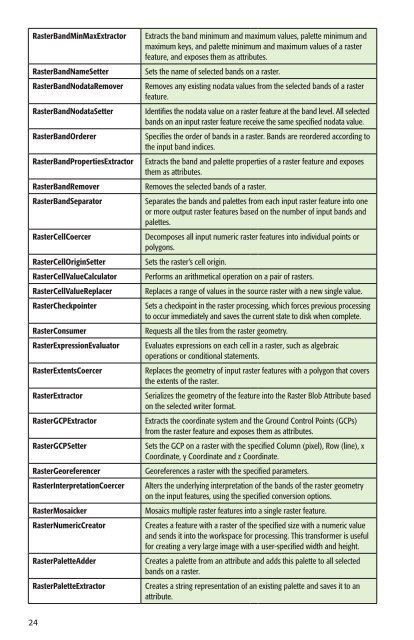
RasterBandMinMaxExtractor Extracts the band minimum and maximum values, palette minimum and<br />
maximum keys, and palette minimum and maximum values of a raster<br />
feature, and exposes them as attributes.<br />
RasterBandNameSetter Sets the name of selected bands on a raster.<br />
RasterBandNodataRemover Removes any existing nodata values from the selected bands of a raster<br />
feature.<br />
RasterBandNodataSetter Identifies the nodata value on a raster feature at the band level. All selected<br />
bands on an input raster feature receive the same specified nodata value.<br />
RasterBandOrderer Specifies the order of bands in a raster. Bands are reordered according to<br />
the input band indices.<br />
RasterBandPropertiesExtractor Extracts the band and palette properties of a raster feature and exposes<br />
them as attributes.<br />
RasterBandRemover Removes the selected bands of a raster.<br />
RasterBandSeparator Separates the bands and palettes from each input raster feature into one<br />
or more output raster features based on the number of input bands and<br />
palettes.<br />
RasterCellCoercer Decomposes all input numeric raster features into individual points or<br />
polygons.<br />
RasterCellOriginSetter Sets the raster’s cell origin.<br />
RasterCellValueCalculator Performs an arithmetical operation on a pair of rasters.<br />
RasterCellValueReplacer Replaces a range of values in the source raster with a new single value.<br />
RasterCheckpointer Sets a checkpoint in the raster processing, which forces previous processing<br />
to occur immediately and saves the current state to disk when complete.<br />
RasterConsumer Requests all the tiles from the raster geometry.<br />
RasterExpressionEvaluator Evaluates expressions on each cell in a raster, such as algebraic<br />
operations or conditional statements.<br />
RasterExtentsCoercer Replaces the geometry of input raster features with a polygon that covers<br />
the extents of the raster.<br />
RasterExtractor Serializes the geometry of the feature into the Raster Blob Attribute based<br />
on the selected writer format.<br />
RasterGCPExtractor Extracts the coordinate system and the Ground Control Points (GCPs)<br />
from the raster feature and exposes them as attributes.<br />
RasterGCPSetter Sets the GCP on a raster with the specified Column (pixel), Row (line), x<br />
Coordinate, y Coordinate and z Coordinate.<br />
RasterGeoreferencer Georeferences a raster with the specified parameters.<br />
RasterInterpretationCoercer Alters the underlying interpretation of the bands of the raster geometry<br />
on the input features, using the specified conversion options.<br />
RasterMosaicker Mosaics multiple raster features into a single raster feature.<br />
RasterNumericCreator Creates a feature with a raster of the specified size with a numeric value<br />
and sends it into the workspace for processing. This transformer is useful<br />
for creating a very large image with a user-specified width and height.<br />
RasterPaletteAdder Creates a palette from an attribute and adds this palette to all selected<br />
bands on a raster.<br />
RasterPaletteExtractor Creates a string representation of an existing palette and saves it to an<br />
attribute.<br />
24