

rockbank north development contributions plan - Growth Areas ...
rockbank north development contributions plan - Growth Areas ...
rockbank north development contributions plan - Growth Areas ...

Create successful ePaper yourself
Turn your PDF publications into a flip-book with our unique Google optimized e-Paper software.
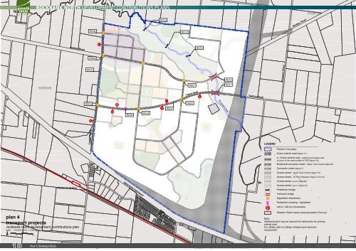
<strong>plan</strong> 4<br />
transport projects<br />
Rockbank Station<br />
Beattys Road<br />
<strong>rockbank</strong> <strong>north</strong> <strong>development</strong> <strong>contributions</strong> <strong>plan</strong><br />
scale: 1:15,000 @ A3, 1:7,500 @ A1<br />
0 100 200 400m<br />
10<br />
ROCKBANK NORTH DEVELOPMENT CONTRIBUTIONS PLANS<br />
Part 1: Strategic Basis<br />
RD02<br />
RD03<br />
Leakes Road<br />
RD08<br />
RD06<br />
RD09<br />
WESTERN FREEWAY<br />
RD04<br />
RD12<br />
RD01<br />
RD12<br />
RD07<br />
Taylors Road<br />
RD05<br />
RD12<br />
Kororoit Creek<br />
RD10<br />
RD11<br />
Taylors Road<br />
LEGEND<br />
Tarletons Road<br />
Plumpton Road<br />
Precinct boundary<br />
6 lane arterial road (figure 11)<br />
4 - 6 lane arterial road - widening of Leakes road<br />
to occur to the west outside of PSP (figure 10)<br />
Boulevard connector street - Major Town Centre (figure 8)<br />
Connector street (figure 7)<br />
Access street - Local Town Centre (figure 12)<br />
Access street - for Fire Protection (figure 13 & 14)<br />
Access street ( level 2) (figure6)<br />
Access street ( level 1) (figure 5)<br />
Pedestrian bridge<br />
Vehicular bridge<br />
Beattys Road<br />
Signalised intersection<br />
Pedestrian crossing - signalised<br />
Left-in / left-out movements<br />
Western Water sewer pumping station (Planned)<br />
Note:<br />
Additional land may be required for earthworks for primary<br />
arterial road .<br />
For utilities refer to Utilities Infrastructure Services<br />
Assessment<br />
SM | 20120319 02:20


