

rockbank north development contributions plan - Growth Areas ...
rockbank north development contributions plan - Growth Areas ...
rockbank north development contributions plan - Growth Areas ...

Create successful ePaper yourself
Turn your PDF publications into a flip-book with our unique Google optimized e-Paper software.
14<br />
14<br />
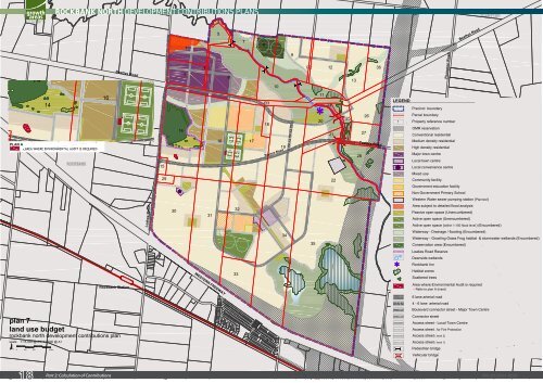
PLAN A<br />
- AREA WHERE ENVIRONMENTAL AUDIT IS REQUIRED<br />
16<br />
<strong>plan</strong> 7<br />
land use budget<br />
<strong>rockbank</strong> <strong>north</strong> <strong>development</strong> <strong>contributions</strong> <strong>plan</strong><br />
scale: 1:15,000 @ A3, 1:7,500 @ A1<br />
0 100 200 400m<br />
18<br />
ROCKBANK NORTH DEVELOPMENT CONTRIBUTIONS PLANS<br />
Part 2: Calculation of Contributions<br />
Beattys Road<br />
Rockbank Station<br />
Leakes Road<br />
15<br />
29<br />
30<br />
14<br />
1<br />
2<br />
R1<br />
31<br />
4<br />
5<br />
16<br />
WESTERN FREEWAY<br />
6<br />
3<br />
32<br />
33<br />
7<br />
17<br />
8<br />
R3<br />
18<br />
10<br />
19<br />
Taylors Road<br />
34<br />
9<br />
R2<br />
35<br />
11<br />
20<br />
12<br />
24<br />
21<br />
22<br />
23<br />
25<br />
13<br />
R4<br />
28<br />
Kororoit Creek<br />
27<br />
26<br />
36<br />
Taylors Road<br />
LEGEND<br />
Precinct boundary<br />
Parcel boundary<br />
1 Property reference number<br />
OMR reservation<br />
Conventional residential<br />
Medium density residential<br />
High density residential<br />
Major town centre<br />
Local town centre<br />
Local convenience centre<br />
Mixed use<br />
Community facility<br />
Government education facility<br />
Non-Government Primary School<br />
Western Water sewer pumping station (Planned)<br />
Area subject to detailed flood analysis<br />
Passive open space (Unencumbered)<br />
Active open space (Unencumbered)<br />
Active open space (within 1:100 flood level) (Encumbered)<br />
Waterway - Drainage / flooding (Encumbered)<br />
Waterway - Growling Grass Frog habitat & stormwater wetlands (Encumbered)<br />
Conservation area (Encumbered)<br />
Leakes Road Reserve<br />
Deanside wetlands<br />
Rockbank Inn<br />
Habitat zones<br />
Scattered trees<br />
Plumpton Road<br />
Beattys Road<br />
Area where Environmental Audit is required<br />
- Refer to <strong>plan</strong> A (inset)<br />
6 lane arterial road<br />
4 - 6 lane arterial road<br />
Boulevard connector street - Major Town Centre<br />
Connector street<br />
Access street - Local Town Centre<br />
Access street - for Fire Protection<br />
Access street ( level 2)<br />
Access street ( level 1)<br />
Pedestrian bridge<br />
Vehicular bridge<br />
SM | 20120319 02:20


