

rockbank north development contributions plan - Growth Areas ...
rockbank north development contributions plan - Growth Areas ...
rockbank north development contributions plan - Growth Areas ...

You also want an ePaper? Increase the reach of your titles
YUMPU automatically turns print PDFs into web optimized ePapers that Google loves.
es Road<br />
Beattys Road<br />
ROCKBANK NORTH DEVELOPMENT CONTRIBUTIONS PLAN<br />
MARCH 2012<br />
Taylors Road<br />
Kororoit Creek<br />
Taylor
This page has been intentionally left blank.
CONTENTs<br />
InTroducTIon 3<br />
1.0 sTRATEGIC BAsIs 5<br />
1.1 PLAnnIng And EnvIronmEnT AcT 1987 5<br />
1.2 PrEcIncT STrucTurE PLAn 7<br />
1.3 ThE ArEA To whIch ThE dEvELoPmEnT conTrIBuTIonS PLAn APPLIES 9<br />
1.4 InfrASTrucTurE ProjEcT juSTIfIcATIon 9<br />
1.5 InfrASTrucTurE ProjEcTS 11<br />
2.0 CALCULATION OF CONTRIBUTIONs 17<br />
2.1 cALcuLATIon of nET dEvELoPABLE & And dEmAnd unITS 17<br />
2.2 cALcuLATIon of conTrIBuTIon chArgES 22<br />
3.0 ADMINIsTRATION AND IMPLEMENTATION 30<br />
3.1 AdmInISTrATIon of ThE dcP 30<br />
3.2 ImPLEmEnTATIon STrATEgy 32<br />
ROCKBANK NORTH DEVELOPMENT CONTRIBUTIONS PLANS<br />
PLAnS<br />
Plan 1: Metropolitan & Regional Context 4<br />
Plan 2: Future Urban Structure 6<br />
Plan 3: DCP <strong>Areas</strong> 8<br />
Plan 4: Roads and Intersections Projects 10<br />
Plan 5: Community Facilities 14<br />
Plan 6: Active Recreation Projects 18<br />
Plan 7: Land Use Budget 26<br />
TABLES<br />
Table 1: Summary Land Use 19<br />
Table 2: Property Specific Land Budget 20<br />
Table 3: Infrastructure Project Justification 24<br />
Table 4: Calculation of Costs 26<br />
Table 5: Project Costs Recovered by the DCP 28<br />
Table 6: Summary of Charges 29<br />
Table 7: Items Suitable for Delivery as Works in Kind 33<br />
1
2<br />
ROCKBANK NORTH DEVELOPMENT CONTRIBUTIONS PLANS<br />
This page has been intentionally left blank.<br />
SM | 20120319 02:20
INTRODUCTION<br />
Purpose<br />
The Rockbank North Development Contributions Plan (Development<br />
Contributions Plan) has been prepared by the <strong>Growth</strong> <strong>Areas</strong> Authority<br />
with the assistance of Melton Shire Council, Government agencies,<br />
service authorities and major stakeholders.<br />
The Development Contributions Plan:<br />
• Outlines projects required to ensure that future residents,<br />
visitors and workers within the Rockbank North area can be<br />
provided with timely access to services and transport necessary<br />
to support a quality, affordable lifestyle.<br />
• Details requirements that must be met by future land use and<br />
<strong>development</strong> and provides developers, investors and local<br />
communities with certainty about <strong>development</strong> contribution<br />
requirements and how they will be administered; and<br />
• Establishes a framework for <strong>development</strong> proponents to<br />
contribute a fair proportion towards the cost of works, services<br />
and facilities for the new community at Rockbank North. It<br />
ensures the cost of providing new infrastructure and services<br />
is shared equitably between various <strong>development</strong> proponents<br />
and the wider community. Fairness requires costs to be<br />
apportioned according to the projected share of use of the<br />
required works, services and facilities item.<br />
report Structure<br />
The Development Contributions Plan document comprises three parts.<br />
PART 1<br />
Part 1 explains the strategic basis for the Development Contributions<br />
Plan, which includes information about the Rockbank North Precinct<br />
Structure Plan and justification for the various infrastructure projects<br />
included in the Development Contributions Plan..<br />
PART 2<br />
Part 2 sets out how the <strong>development</strong> <strong>contributions</strong> are calculated<br />
and costs apportioned.<br />
PART 3<br />
Part 3 focuses on administration and implementation of the<br />
Development Contributions Plan.<br />
ROCKBANK NORTH DEVELOPMENT CONTRIBUTIONS PLANS<br />
Introduction<br />
3
MELTON<br />
TOOLERN<br />
<strong>plan</strong> 1<br />
metropolitan & regional context<br />
<strong>rockbank</strong> <strong>north</strong> <strong>development</strong> <strong>contributions</strong> <strong>plan</strong><br />
4<br />
ROCKBANK NORTH DEVELOPMENT CONTRIBUTIONS PLANS<br />
Part 1: Strategic Basis<br />
Ferris Road<br />
Mt Cottrell Road<br />
Western Freeway<br />
Paynes Road<br />
Beattys Road<br />
Rockbank Station<br />
Leakes Road<br />
Rockbank<br />
Precinct Structure Plan<br />
Troups Road<br />
Melton Highway<br />
Hopkins Road<br />
Rockbank Precinct Structure Plan Area<br />
Major Road Network<br />
OMR<br />
Railway Line<br />
Taylors Road<br />
Western Freeway<br />
Hume Drive<br />
SM | 20120319 02:20<br />
CAROLINE<br />
SPRINGS
1.0 sTRATEGIC BAsIs<br />
The strategic basis for this Development Contributions Plan is established<br />
by the State and Local Planning Policy Framework of the Melton<br />
Planning Scheme. Key documents are Melbourne @ 5 Million, the Draft<br />
2011 <strong>Growth</strong> Corridor Plans, the Municipal Strategic Statement and the<br />
Rockbank North Precinct Structure Plan (and supporting documents).<br />
These documents set out a broad, long term vision for the sustainable<br />
<strong>development</strong> of the Development Contributions Plan area.<br />
The 2011 <strong>Growth</strong> Corridor Plans (currently in draft) will be incorporated<br />
into the Victoria Planning Provisions and illustrate the <strong>plan</strong>ned extent of<br />
residential, employment and other <strong>development</strong> as well as the location<br />
of larger activity centres for each growth area. They also include key<br />
elements of infrastructure and services including the regional open<br />
space network, the location of public transport networks, freeways and<br />
arterial roads.<br />
The Rockbank North Precinct Structure Plan has been developed<br />
following a comprehensive <strong>plan</strong>ning process and provides the principal<br />
strategic basis for this Development Contributions Plan.<br />
1.1 PLAnnIng And EnvIronmEnT AcT 1987<br />
This Development Contributions Plan has been prepared in accordance<br />
with Part 3B of the Planning and Environment Act 1987 (Act) and has been<br />
developed in line with the State and Local Planning Policy Framework of<br />
the Melton Planning Scheme as well as Victorian Government Guidelines<br />
for the preparation of Development Contributions Plans.<br />
The Development Contributions Plan provides for the charging of a<br />
‘<strong>development</strong> infrastructure levy’ pursuant to section 46J(a) of the Act<br />
towards works, services or facilities. It also provides for the charging of<br />
a ‘community infrastructure levy’ pursuant to section 46J(b) of the Act<br />
as some items are classified as community infrastructure under the Act.<br />
This Development Contributions Plan forms part of the Melton Planning<br />
Scheme pursuant to section 46I of the Act and is an incorporated<br />
document under Clause 81 of the Planning Scheme.<br />
This Development Contributions Plan will be implemented in the Melton<br />
Planning Scheme through Schedule 4 to the Development Contributions<br />
Plan Overlay. The land to which this DCP applies is shown in Plan 3.<br />
ROCKBANK NORTH DEVELOPMENT CONTRIBUTIONS PLANS<br />
Part 1: Strategic Basis<br />
5
Rockbank Station<br />
<strong>plan</strong> 2<br />
future urban structure<br />
<strong>rockbank</strong> <strong>north</strong> <strong>development</strong> <strong>contributions</strong> <strong>plan</strong><br />
scale: 1:15,000 @ A3, 1:7,500 @ A1<br />
0 100 200 400m<br />
6<br />
ROCKBANK NORTH DEVELOPMENT CONTRIBUTIONS PLANS<br />
Part 1: Strategic Basis<br />
Beattys Road<br />
Leakes Road<br />
WESTERN FREEWAY<br />
Taylors Road<br />
Kororoit Creek<br />
Taylors Road<br />
LEGEND<br />
Precinct boundary<br />
OMR reservation<br />
Conventional residential<br />
Medium density residential<br />
High density residential<br />
Major town centre<br />
Local town centre<br />
Local convenience centre<br />
Mixed use<br />
Plumpton Road<br />
Community facility<br />
Government education facility<br />
Non-Government Primary School<br />
Western Water sewer pumping station (Planned)<br />
Area subject to detailed flood analysis<br />
Passive open space (Unencumbered)<br />
Active open space (Unencumbered)<br />
Active open space (within 1:100 flood level) (Encumbered)<br />
Waterway - Drainage / flooding (Encumbered)<br />
Waterway - Growling Grass Frog habitat & stormwater wetlands (Encumbered)<br />
Conservation area (Encumbered)<br />
Leakes Road Reserve<br />
Deanside wetlands<br />
Rockbank Inn<br />
Habitat zones<br />
Scattered trees<br />
6 lane arterial road<br />
4 - 6 lane arterial road<br />
Boulevard connector street - Major Town Centre<br />
Connector street<br />
Access street - Local Town Centre<br />
Access street - for Fire Protection<br />
Access street ( level 2)<br />
Access street ( level 1)<br />
Pedestrian bridge<br />
Vehicular bridge<br />
Beattys Road<br />
SM | 20120319 02:20
1.2 PrEcIncT STrucTurE PLAn<br />
The Rockbank North Precinct Structure Plan area is located <strong>north</strong> of the<br />
Western Highway, bound by Leakes Road to the west and the OMR/E6<br />
reservation to the east. (Refer to Plan 1)<br />
The Rockbank North Precinct Structure Plan area is expected to:<br />
• Grow by up to 20,400 people, accommodated in approximately<br />
7,300 households; and<br />
• Generate up to 3,900 jobs in land uses in the Precinct Structure<br />
Plan area.<br />
The Rockbank North Precinct Structure Plan establishes the future<br />
urban structure of the new community which proposes a range of<br />
networks including: transport, open space and active recreation, social<br />
infrastructure, activity centres, residential neighbourhoods and places<br />
for local employment (Refer Plan 2).<br />
The need for the infrastructure has been determined according to the<br />
anticipated <strong>development</strong> scenario for Rockbank North as described<br />
in the Rockbank North Precinct Structure Plan. The Development<br />
Contributions Plan has a strong relationship to the Rockbank North<br />
Precinct Structure Plan, as the Rockbank North Precinct Structure Plan<br />
provides the rationale and justification for infrastructure items that have<br />
been included within the Development Contributions Plan.<br />
Accordingly, the Development Contributions Plan is an implementation<br />
based <strong>plan</strong>ning tool which identifies the infrastructure items required by<br />
the new community and apportions the cost of this infrastructure in an<br />
equitable manner across the <strong>plan</strong> area.<br />
ROCKBANK NORTH DEVELOPMENT CONTRIBUTIONS PLANS<br />
Part 1: Strategic Basis<br />
7
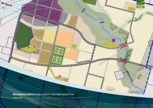
<strong>plan</strong> 3<br />
DCP area<br />
<strong>rockbank</strong> <strong>north</strong> <strong>development</strong> <strong>contributions</strong> <strong>plan</strong><br />
scale: 1:20,000 @ A3, 1:10,000 @ A1<br />
0 100 200 600m<br />
8<br />
ROCKBANK NORTH DEVELOPMENT CONTRIBUTIONS PLANS<br />
Part 1: Strategic Basis<br />
Beattys Road<br />
Rockbank Station<br />
Leakes Road<br />
WESTERN FREEWAY<br />
Tarletons Road<br />
Kororoit Creek<br />
Plumpton Road<br />
Beattys Road<br />
Taylors Road<br />
LEGEND<br />
Precinct boundary<br />
Parcel boundary<br />
OMR reservation<br />
Existing road reserve<br />
Rail line (with station)<br />
SM | 20120319 02:20
1.3 ThE ArEA To whIch ThE dEvELoPmEnT<br />
conTrIBuTIonS PLAn APPLIES<br />
The Development Contributions Plan applies to land shown in Plan 3.<br />
The Rockbank North Precinct Structure Plan applies to approximately<br />
786 hectares of land as shown in Plans 2 and 3. The Development<br />
Contributions Plan area covers the same area as the Rockbank North<br />
Precinct Structure Plan and comprises one Main Catchment Area (MCA).<br />
The MCA defines the main catchment area for the various infrastructure<br />
projects required with the Rockbank North Precinct Structure Plan. The<br />
MCA is the geographic area from which a given item of infrastructure<br />
will draw most of its use.<br />
In selecting items, consideration has been given to ensure they are<br />
not already wholly funded through another contribution mechanism,<br />
such as a mandatory infrastructure construction requirement of the<br />
Rockbank North Precinct Structure Plan, an existing local Development<br />
Contributions Plan, an agreement under section 173 of the Act, or as a<br />
condition on an existing <strong>plan</strong>ning permit.<br />
1.4 InfrASTrucTurE ProjEcT juSTIfIcATIon<br />
1.4.1 INTRODUCTION<br />
The need for infrastructure has been determined according to the<br />
anticipated <strong>development</strong> scenario for Rockbank North as described<br />
in the Rockbank North Precinct Structure Plan and its supporting<br />
documents.<br />
Items can be included in a <strong>development</strong> <strong>contributions</strong> <strong>plan</strong> if they will<br />
be used by the future community of an area. New <strong>development</strong> does not<br />
have to trigger the need for new items in its own right. The <strong>development</strong><br />
is charged in line with its projected share of use. An item can be included<br />
in a <strong>development</strong> <strong>contributions</strong> <strong>plan</strong> regardless of whether it is within or<br />
outside the <strong>development</strong> <strong>contributions</strong> <strong>plan</strong> area.<br />
Before inclusion in this Development Contributions Plan, all items have<br />
been assessed to ensure they have a relationship or nexus to proposed<br />
<strong>development</strong> in the Rockbank North Precinct Structure Plan area.<br />
The cost apportionment methodology adopted in this Development<br />
Contributions Plan relies on the nexus principle. A new <strong>development</strong> is<br />
deemed to have a nexus with an item if it is expected to make use of<br />
that item. A summary of how each item relates to projected growth area<br />
<strong>development</strong> is set out below and individual item use catchments are<br />
identified in Table 4.<br />
The items that have been included in this Development Contributions<br />
Plan all have the following characteristics:<br />
• they are essential to the health, safety and well-being of the<br />
community;<br />
• they will be used by a broad cross-section of the community;<br />
• they reflect the vision and strategic aspirations as expressed in the<br />
Rockbank North Precinct Structure Plan;<br />
• They are not projects for which the State Government is<br />
responsible (this is a requirement of Section 46IA of the Act where<br />
the land included within the Development Contribution Plan is<br />
also subject to the <strong>Growth</strong> Aras Infrastructure Contribution Charge<br />
(GAIC); and<br />
• they are not recurrent items.<br />
ROCKBANK NORTH DEVELOPMENT CONTRIBUTIONS PLANS<br />
1.4.2 ITEMS NOT INCLUDED IN THE DEVELOPMENT CONTRIBUTIONS<br />
PLAN<br />
The items listed below are not included in the Development Contributions<br />
Plan, as they are not considered to be higher order items. These items<br />
must be provided by developers as a matter of course and or pursuant<br />
to agreements with servicing agencies:<br />
• All internal streets and connector streets, and associated traffic<br />
management measures. This includes streets on the edge of the<br />
Rockbank North Precinct Structure Plan.<br />
• Intersections connecting the <strong>development</strong> to the existing road<br />
network, except where specified in the <strong>development</strong> contribution<br />
<strong>plan</strong> projects.<br />
• Flood mitigation works;<br />
• Local drainage systems;<br />
• Water, sewerage, underground power, gas, telecommunications<br />
services;<br />
• Local pathways and connections to the regional and/or district<br />
pathway network;<br />
• Basic levelling, water tapping and landscaping of open space;<br />
• Passive public open space and any agreed associated works<br />
required by the PSP;<br />
• Council’s <strong>plan</strong> checking and supervision costs; and<br />
• Bus stops.<br />
Table 3 – “Infrastructure Project Justification” provides an ex<strong>plan</strong>ation of<br />
all projects in the Development Contributions Plan, which are described<br />
below.<br />
Part 1: Strategic Basis<br />
9
<strong>plan</strong> 4<br />
transport projects<br />
Rockbank Station<br />
Beattys Road<br />
<strong>rockbank</strong> <strong>north</strong> <strong>development</strong> <strong>contributions</strong> <strong>plan</strong><br />
scale: 1:15,000 @ A3, 1:7,500 @ A1<br />
0 100 200 400m<br />
10<br />
ROCKBANK NORTH DEVELOPMENT CONTRIBUTIONS PLANS<br />
Part 1: Strategic Basis<br />
RD02<br />
RD03<br />
Leakes Road<br />
RD08<br />
RD06<br />
RD09<br />
WESTERN FREEWAY<br />
RD04<br />
RD12<br />
RD01<br />
RD12<br />
RD07<br />
Taylors Road<br />
RD05<br />
RD12<br />
Kororoit Creek<br />
RD10<br />
RD11<br />
Taylors Road<br />
LEGEND<br />
Tarletons Road<br />
Plumpton Road<br />
Precinct boundary<br />
6 lane arterial road (figure 11)<br />
4 - 6 lane arterial road - widening of Leakes road<br />
to occur to the west outside of PSP (figure 10)<br />
Boulevard connector street - Major Town Centre (figure 8)<br />
Connector street (figure 7)<br />
Access street - Local Town Centre (figure 12)<br />
Access street - for Fire Protection (figure 13 & 14)<br />
Access street ( level 2) (figure6)<br />
Access street ( level 1) (figure 5)<br />
Pedestrian bridge<br />
Vehicular bridge<br />
Beattys Road<br />
Signalised intersection<br />
Pedestrian crossing - signalised<br />
Left-in / left-out movements<br />
Western Water sewer pumping station (Planned)<br />
Note:<br />
Additional land may be required for earthworks for primary<br />
arterial road .<br />
For utilities refer to Utilities Infrastructure Services<br />
Assessment<br />
SM | 20120319 02:20
1.5 InfrASTrucTurE ProjEcTS<br />
1.5.1 TRANSPORT<br />
The key transport related projects in the Development Contributions Plan are based on the transport network<br />
depicted in Plan 4 which is based on Vicroads modelling and more detailed work undertaken by GTA Consultants.<br />
Refer to Plan 4 – roads and intersections projects.<br />
The transport projects comprise of two categories:<br />
• road construction; and<br />
• construction of controlled intersections.<br />
The road and intersection projects funded by the Development Contributions Plan include:<br />
dcP ProjEcT<br />
numBEr<br />
rd01<br />
dEScrIPTIon<br />
East-west arterial between Leakes Road and the Outer Metropolitan Ring Road. Land acquisition for<br />
ultimate and construction of the first carriageway.<br />
ToTAL ProjEcT<br />
coST $2011<br />
$ 6,076,000<br />
rd02 North-south arterial (Leakes Rd). Construction of first carriageway. $ 3,558,000<br />
rd03<br />
rd04<br />
rd05<br />
rd06<br />
rd07<br />
rd08<br />
Intersection. Land acquisition for ultimate and construction of an interim signalised T-intersection at the<br />
intersection of the <strong>north</strong> south arterial (Leakes Rd) and the east-west arterial (Taylors Rd)<br />
Intersection. Land acquisition for ultimate and construction of an interim signalised intersection at western<br />
connector street and the east-west arterial (Taylors Road).<br />
Intersection. Land acquisition for ultimate and construction of an interim signalised intersection at the<br />
intersection of the <strong>north</strong> south arterial and the east-west arterial (Taylors Road).<br />
Intersection. Land acquisition for ultimate and construction of an interim signalised intersection at the<br />
intersection of the Beattys Road collector and Leakes Road.<br />
Intersection. Land and construction of an interim signalised intersection of Beattys Road and <strong>north</strong> south<br />
arterial.<br />
Intersection. Land acquisition for ultimate and construction of an interim signalised intersection of the<br />
Major Town Centre and Leakes Road.<br />
$ 8,306,250<br />
$ 11,333,250<br />
$ 10,002,250<br />
$ 5,071,000<br />
$ 3,758,500<br />
$ 2,133,750<br />
rd09 Pedestrian Crossing. Construction of pedestrian crossing on Taylors Rd. $ 297,000<br />
rd10 Vehicle Bridge 1. Construction of a two lane bridge over Kororoit Creek. $ 5,622,000<br />
rd11 Vehicle Bridge 2. Construction of a two lane bridge over Kororoit Creek. $ 5,622,000<br />
rd12 Pedestrians Bridge Construction of 3 pedestrian bridges over Kororoit Creek. $ 600,000<br />
TOTAL $ 62,380,000<br />
ROCKBANK NORTH DEVELOPMENT CONTRIBUTIONS PLANS<br />
Part 1: Strategic Basis<br />
11
Rockbank Station<br />
Beattys Road<br />
<strong>plan</strong> 5<br />
community facilities and recreation projects<br />
<strong>rockbank</strong> <strong>north</strong> <strong>development</strong> <strong>contributions</strong> <strong>plan</strong><br />
scale: 1:15,000 @ A3, 1:7,500 @ A1<br />
0 100 200 400m<br />
12<br />
ROCKBANK NORTH DEVELOPMENT CONTRIBUTIONS PLANS<br />
Part 1: Strategic Basis<br />
Leakes Road<br />
C05<br />
WESTERN FREEWAY<br />
C06<br />
C03 + C04<br />
Taylors Taylors Taylors Taylors Taylors Taylors Taylors Taylors Taylors Road Road Road Road Road Road Road Road Road<br />
C01 + C02<br />
Kororoit Kororoit Kororoit Kororoit Kororoit Kororoit Kororoit Kororoit Kororoit Kororoit Kororoit Kororoit Kororoit Kororoit Kororoit Kororoit Kororoit Kororoit Kororoit Kororoit Kororoit Kororoit Kororoit Kororoit Kororoit Kororoit Kororoit Kororoit Kororoit Kororoit Kororoit Kororoit Kororoit Kororoit Kororoit Kororoit Kororoit Kororoit Kororoit Kororoit Kororoit Kororoit Kororoit Kororoit Kororoit Kororoit Kororoit Kororoit Kororoit Kororoit Kororoit Kororoit Kororoit Kororoit Kororoit Kororoit Kororoit Kororoit Creek Creek Creek Creek Creek Creek Creek Creek Creek Creek Creek Creek Creek Creek Creek Creek Creek Creek Creek Creek Creek Creek Creek Creek Creek Creek Creek Creek Creek Creek Creek Creek Creek Creek Creek Creek Creek Creek Creek Creek Creek Creek Creek Creek Creek Creek Creek Creek Creek Creek Creek Creek Creek Creek Creek Creek Creek Creek<br />
Taylors Road<br />
Plumpton Road<br />
Beattys Road<br />
LEGEND<br />
Precinct boundary<br />
Community facility<br />
SM | 20120319 02:20
1.5.2 COMMUNITy FACILITIES<br />
The needs analysis undertaken by ASR Research and Melton Shire Council determined the requirement for a range of<br />
community facilities which are illustrated in Plan 5 – Community facilities projects.<br />
The community and indoor facility projects funded by the Development Contributions Plan include:<br />
dcP ProjEcT<br />
numBEr<br />
dEScrIPTIon<br />
ToTAL ProjEcT coST<br />
$2011<br />
c01 Land for Community Centre 1. Land acquisition of 0.8 hectares for Community Centre. $ 1,400,000<br />
c02<br />
Construction of Community Centre 1. Construction of multi-purpose community centre including<br />
maternal and child health care services, pre-school and associated facilities including car parking and<br />
landscape works.<br />
$ 5,657,000<br />
c03 Land for Community Centre 2. Land acquisition of 0.8 hectares for future Community Centre 2. $ 1,400,000<br />
c04<br />
c05<br />
c06<br />
Construction of Community Centre 2. Construction of multi-purpose community facility including<br />
maternal and child health facility, pre-school, consulting suites and multi-purpose space and associated<br />
facilities including car parking and landscape works.<br />
Library and Higher Order Community Centre 3. Land acquisition of 2 hectares for Library and Higher<br />
Order Community Facility within Rockbank North Major Town Centre.<br />
Indoor Sports Centre Land acquisition for Indoor sports Centre adjoining the Rockbank North Major<br />
Town Centre.<br />
$ 5,657,000<br />
$ 3,000,000<br />
$ 5,750,000<br />
TOTAL $ 22,864,000<br />
ROCKBANK NORTH DEVELOPMENT CONTRIBUTIONS PLANS<br />
Part 1: Strategic Basis<br />
13
Rockbank Station<br />
<strong>plan</strong> 6<br />
active recreation projects<br />
<strong>rockbank</strong> <strong>north</strong> <strong>development</strong> <strong>contributions</strong> <strong>plan</strong><br />
scale: 1:15,000 @ A3, 1:7,500 @ A1<br />
0 100 200 400m<br />
14<br />
ROCKBANK NORTH DEVELOPMENT CONTRIBUTIONS PLANS<br />
Part 1: Strategic Basis<br />
OS08 - provided<br />
outside the precinct<br />
Beattys Road<br />
Leakes Road<br />
OS09<br />
OS03<br />
OS01 + OS02<br />
WESTERN FREEWAY<br />
OS04 + OS05<br />
Taylors Taylors Taylors Taylors Taylors Taylors Taylors Taylors Taylors Road Road Road Road Road Road Road Road Road<br />
OS06 + OS07<br />
Kororoit Kororoit Kororoit Kororoit Kororoit Kororoit Kororoit Kororoit Kororoit Kororoit Kororoit Kororoit Kororoit Kororoit Kororoit Kororoit Kororoit Kororoit Kororoit Kororoit Kororoit Kororoit Kororoit Kororoit Kororoit Kororoit Kororoit Kororoit Kororoit Kororoit Kororoit Kororoit Kororoit Kororoit Kororoit Kororoit Kororoit Kororoit Kororoit Kororoit Kororoit Kororoit Kororoit Kororoit Kororoit Kororoit Kororoit Kororoit Kororoit Kororoit Kororoit Kororoit Kororoit Kororoit Kororoit Kororoit Kororoit Kororoit Creek Creek Creek Creek Creek Creek Creek Creek Creek Creek Creek Creek Creek Creek Creek Creek Creek Creek Creek Creek Creek Creek Creek Creek Creek Creek Creek Creek Creek Creek Creek Creek Creek Creek Creek Creek Creek Creek Creek Creek Creek Creek Creek Creek Creek Creek Creek Creek Creek Creek Creek Creek Creek Creek Creek Creek Creek Creek<br />
Taylors Road<br />
Plumpton Road<br />
LEGEND<br />
Beattys Road<br />
Precinct boundary<br />
Active open space (Unencumbered)<br />
Active open space (within 1:100 flood level ) (Encumbered)<br />
SM | 20120319 02:20
1.5.3 ACTIVE RECREATION<br />
The analysis undertaken by ASR Research and Melton Shire Council determined a number of facilities required to be<br />
built on the various active open space areas to meet the needs of the future community, illustrated in Plan 6 – Active<br />
recreation facilities projects.<br />
The active recreation projects funded by the Development Contributions Plan include<br />
dcP ProjEcT<br />
numBEr<br />
oS01<br />
dEScrIPTIon<br />
Active Playing Fields 1. Land and construction of 2 football/cricket ovals, cricket nets,including lighting,<br />
drainage and associated car parking and landscape works.<br />
*OS06 – Active Playing Fields 3 – The total facility comprises 8 hectares of which 1.7 hectares is unencumbered and therefore<br />
included in the DCP. The balance of the 6.3 hectares is located within the 1:100 year flood plain and the land purchase is<br />
therefore not included in the DCP.<br />
Passive open space <strong>contributions</strong> are also required under Clause 52.01 of the Melton Planning Scheme.<br />
ToTAL ProjEcT<br />
coST $2011<br />
$ 12,901,000<br />
oS02 Active Playing Fields 1 Pavilion. Construction of a sports pavilion. $ 1,900,000<br />
oS03 Tennis Courts. Land and construction of a 10 tennis court facility. $ 3,410,000<br />
oS04<br />
Active Playing Fields 2. Land and construction of 4 soccer fields including drainage, lighting, car parking<br />
and associated landscape works.<br />
$ 12,056,000<br />
oS05 Active Playing Fields 2 Pavilion. Construction of sports pavilion. $ 1,900,000<br />
oS06<br />
Active Playing Fields 3. Land and construction of AFL ovals including drainage, lighting, car parking<br />
and associated landscape works. Ovals provided as part of floodplain.<br />
$ 7,001,000<br />
oS07 Active Playing Fields 3 Pavilion. Construction of sports pavilion. $ 1,900,000<br />
oS08<br />
oS09<br />
District Active Open Space. Land acquisition of 30ha of district open space to service broader<br />
community.<br />
Town Square. Land for the <strong>development</strong> of a town square within the Rockbank North Major Town<br />
Centre.<br />
$ 15,000,000<br />
$ 1,000,000<br />
TOTAL $ 57,068,000<br />
ROCKBANK NORTH DEVELOPMENT CONTRIBUTIONS PLANS<br />
Part 1: Strategic Basis<br />
15
1.6 ProjEcT TImIng<br />
16<br />
ROCKBANK NORTH DEVELOPMENT CONTRIBUTIONS PLANS<br />
Each item in the Development Contributions Plan has an assumed indicative provision trigger specified in Table<br />
3. The timing of the provision of the items in this Development Contributions Plan is consistent with information<br />
available at the time that the Development Contributions Plan was prepared. The Development Agency will<br />
monitor and assess the required timing for individual items and may seek an amendment to the Development<br />
Contributions Plan to adjust indicative provision triggers as part of the 5 year review.<br />
While indicative provision triggers are estimated these do not preclude the early provision of certain infrastructure<br />
to be constructed/ provided by <strong>development</strong> proponents as works or land in-kind, if agreed to by the Collecting<br />
Agency.<br />
Part 1: Strategic Basis<br />
1.7 dISTIncTIon BETwEEn communITy And dEvELoPmEnT InfrASTrucTurE<br />
In accordance with the Act and the Ministerial Direction May 2004 on Development Contributions, the<br />
Development Contributions Plan makes a distinction between “<strong>development</strong>” and “community” infrastructure.<br />
The timing of payment of <strong>contributions</strong> is linked to the type of infrastructure in question.<br />
For community infrastructure, community infrastructure <strong>contributions</strong> are to be made by the home-buyer at the<br />
time of building approval. Contributions relating to community infrastructure will be charged at a “per-dwelling”<br />
rate. The Act stipulates that the amount that may be contributed under a community infrastructure levy is no more<br />
than $900 per dwelling. If the cap is ever increased and the increased amount is equal to or less than the amount<br />
required by the Development Contributions Plan, this higher amount will be deemed to be the community<br />
infrastructure contribution for the purposes of this Development Contributions Plan and it will be the amount<br />
payable from the date it is introduced.<br />
The following infrastructure projects have been classified as community infrastructure:<br />
dcP ProjEcT<br />
numBEr<br />
dEScrIPTIon<br />
oS02 Active Playing Fields 1 Pavilion. Construction of a sports pavilion. $<br />
oS05 Active Playing Fields 2 Pavilion. Construction of sports pavilion. $<br />
oS07 Active Playing Fields 3 Pavilion. Construction of sports pavilion. $<br />
TOTAL $<br />
ToTAL<br />
ProjEcT coST<br />
$2011<br />
1,900,000<br />
1,900,000<br />
1,900,000<br />
5,700,000<br />
All other infrastructure projects are considered to be in the <strong>development</strong> infrastructure category. Contributions<br />
relating to <strong>development</strong> infrastructure are to be made by developers at the time of subdivision. If subdivision is<br />
not applicable, payments must be made prior to construction of works.<br />
SM | 20120319 02:20
2.0 CALCULATION OF CONTRIBUTIONs<br />
Part 1 sets out the strategic basis for this Development Contributions Plan<br />
and identifies infrastructure items to be included in the Development<br />
Contributions Plan. Part 2 focuses on the calculation of <strong>contributions</strong><br />
and apportionment of costs.<br />
The general cost apportionment method includes the following steps:<br />
• Calculation of the net developable area and demand units (refer<br />
Table 1 & 2)<br />
• Calculation of project costs (refer Table 4)<br />
• Identification and allowance for external use (refer Table4)<br />
• Cost apportionment and catchments (refer Table 4)<br />
• Identification of <strong>development</strong> types required to pay the levy (Refer<br />
to Table 6)<br />
• Summary of costs payable by <strong>development</strong> type for each<br />
infrastructure category (refer Table 5)<br />
• Finally, a charge per net developable hectare by <strong>development</strong> type<br />
(Table 6).<br />
2.1 cALcuLATIon of nET dEvELoPABLE ArEA And<br />
dEmAnd unITS<br />
2.1.1 INTRODUCTION<br />
The following section sets out how Net Developable Area is calculated<br />
by, providing a detailed land budget for every property within the<br />
Rockbank North Precinct Structure Plan.<br />
2.1.2 NET DEVELOPABLE AREA<br />
In this Development Contributions Plan, all <strong>development</strong> infrastructure<br />
<strong>contributions</strong> are payable on the Net Developable Area (NDA) on any<br />
given <strong>development</strong> site.<br />
For the purposes of this Development Contributions Plan, Net<br />
Developable Area (NDA) is defined as:<br />
the total amount of land within the precinct that is made available for<br />
<strong>development</strong> of housing and employment buildings, including lots,<br />
local and connector streets.<br />
Put simply, it is the total precinct area minus land for community<br />
facilities, schools and educational facilities open space, encumbered<br />
land and arterial roads. Small local parks defined at the subdivision stage<br />
are included in NDA.<br />
The NDA for the Development Contributions Plan has been assessed<br />
and is specified in Tables 1 and 2.<br />
ROCKBANK NORTH DEVELOPMENT CONTRIBUTIONS PLANS<br />
Part 1: Strategic Basis<br />
17
14<br />
14<br />
PLAN A<br />
- AREA WHERE ENVIRONMENTAL AUDIT IS REQUIRED<br />
16<br />
<strong>plan</strong> 7<br />
land use budget<br />
<strong>rockbank</strong> <strong>north</strong> <strong>development</strong> <strong>contributions</strong> <strong>plan</strong><br />
scale: 1:15,000 @ A3, 1:7,500 @ A1<br />
0 100 200 400m<br />
18<br />
ROCKBANK NORTH DEVELOPMENT CONTRIBUTIONS PLANS<br />
Part 2: Calculation of Contributions<br />
Beattys Road<br />
Rockbank Station<br />
Leakes Road<br />
15<br />
29<br />
30<br />
14<br />
1<br />
2<br />
R1<br />
31<br />
4<br />
5<br />
16<br />
WESTERN FREEWAY<br />
6<br />
3<br />
32<br />
33<br />
7<br />
17<br />
8<br />
R3<br />
18<br />
10<br />
19<br />
Taylors Road<br />
34<br />
9<br />
R2<br />
35<br />
11<br />
20<br />
12<br />
24<br />
21<br />
22<br />
23<br />
25<br />
13<br />
R4<br />
28<br />
Kororoit Creek<br />
27<br />
26<br />
36<br />
Taylors Road<br />
LEGEND<br />
Precinct boundary<br />
Parcel boundary<br />
1 Property reference number<br />
OMR reservation<br />
Conventional residential<br />
Medium density residential<br />
High density residential<br />
Major town centre<br />
Local town centre<br />
Local convenience centre<br />
Mixed use<br />
Community facility<br />
Government education facility<br />
Non-Government Primary School<br />
Western Water sewer pumping station (Planned)<br />
Area subject to detailed flood analysis<br />
Passive open space (Unencumbered)<br />
Active open space (Unencumbered)<br />
Active open space (within 1:100 flood level) (Encumbered)<br />
Waterway - Drainage / flooding (Encumbered)<br />
Waterway - Growling Grass Frog habitat & stormwater wetlands (Encumbered)<br />
Conservation area (Encumbered)<br />
Leakes Road Reserve<br />
Deanside wetlands<br />
Rockbank Inn<br />
Habitat zones<br />
Scattered trees<br />
Plumpton Road<br />
Beattys Road<br />
Area where Environmental Audit is required<br />
- Refer to <strong>plan</strong> A (inset)<br />
6 lane arterial road<br />
4 - 6 lane arterial road<br />
Boulevard connector street - Major Town Centre<br />
Connector street<br />
Access street - Local Town Centre<br />
Access street - for Fire Protection<br />
Access street ( level 2)<br />
Access street ( level 1)<br />
Pedestrian bridge<br />
Vehicular bridge<br />
SM | 20120319 02:20
2.1.3 LAND BUDGET AND DEMAND UNITS<br />
Tables 1 and 2 provide a detailed land budget for the entire Rockbank North Precinct Structure Plan.<br />
The detailed land budget is then broken down further for each land holding within the Rockbank<br />
North Precinct Structure Plan area, as illustrated in Plan 7. Table 2 sets the amount of NDA and land<br />
required for a public purpose in accordance with the Development Contributions Plan, for each<br />
land holding. The resulting Net Developable Hectares is the Demand Unit and therefore the basis<br />
upon which the <strong>development</strong> contribution levies are payable.<br />
Based on the Rockbank North Precinct Structure Plan, there is one <strong>development</strong> type included in<br />
this DCP, which is “residential” and the (NDA) is assessed as 442.82 hectares.<br />
Table 1: SUMMARy LAND USE BUDGET<br />
DEsCRIPTION<br />
hectares<br />
TOTAL PRECINCT AREA (ha) 786.33<br />
AREA 1<br />
% of Total<br />
Area<br />
% of ndA<br />
Outer Metropolitan Ring Road Reservation (PAO) -VicRoads Responsibility 106.56 13.55% 24.06%<br />
GROss PRECINCT AREA (ha) 679.77<br />
TrAnSPorT<br />
6 Lane Arterial roads 3.08 0.45% 0.69%<br />
road Intersections 12.76 1.88% 2.88%<br />
Bus interchange 0.50 0.07% 0.11%<br />
Sub-total<br />
communITy fAcILITIES<br />
16.33 2.40% 3.69%<br />
community facilities 8.60 1.27% 1.94%<br />
Town Square 0.50 0.07% 0.11%<br />
Sub-total 9.10 1.34% 2.06%<br />
govErnmEnT EducATIon<br />
government Schools 15.40 2.27% 3.48%<br />
Sub-total<br />
non-govErnmEnT EducATIon<br />
15.40 2.27% 3.48%<br />
non-government Schools 3.00 0.44% 0.68%<br />
Sub-total 3.00 0.44% 0.68%<br />
oPEn SPAcE<br />
EncumBErEd LAnd whIch mAy BE AvAILABLE for rEcrEATIon<br />
Active open Space (within 1:100 flood level) 6.47 0.95% 1.46%<br />
waterway - drainage / flooding 15.48 2.28% 3.50%<br />
waterway - growling grass frog habitat & Stormwater wetlands 120.36 17.71% 27.18%<br />
conservation <strong>Areas</strong> 12.85 1.89% 2.90%<br />
Sub-total<br />
unEncumBErEd LAnd AvAILABLE for rEcrEATIon<br />
155.16 22.83% 35.04%<br />
Active open Space 19.53 2.9% 4.41%<br />
Passive open Space 16.19 2.4% 3.66%<br />
Sub-total 35.72 5.3% 8.07%<br />
TOTALs OPEN sPACE 190.88 28.1% 43.11%<br />
Sewer Pump Station 2.24 0.33% 0.51%<br />
Sub-total 2.24 0.33% 0.51%<br />
NET DEVELOPABLE AREA (NDA) ha 442.82 65.14%<br />
ROCKBANK NORTH DEVELOPMENT CONTRIBUTIONS PLANS<br />
DEsCRIPTION AREA 1<br />
rETAIL / EmPLoymEnT & oThEr hEcTArES<br />
Town centres (local & major) 36.19<br />
mixed use (Adjacent to major Town centre) 9.47<br />
mixed use (Adjacent to Local Town centre) 0.90<br />
Subtotal 46.56<br />
rESIdEnTIAL nrA (ha) dwELL / nrhA dwELLIngS<br />
residential - conventional density residential 319.23 14 4469<br />
residential - medium density 47.28 25 1182<br />
residential - high density 29.75 35 1041<br />
residential - in mixed use (Adjacent to major Town centre) 0.00 0 188<br />
residential - in mixed use (Adjacent to Local Town centre) 0.00 0 17<br />
residential - in LTc 0.00 0 35<br />
residential - in mTc 0.00 0 350<br />
Subtotal Against net residential Area (nrA) 396.26 18.38 7282<br />
comBInEd rES/ rETAIL / EmP / oThEr nrA (ha) dwELL / nrhA dwELLIngS<br />
Total Residential Yield Against NDA 442.82 16.45 7282<br />
Part 2: Calculation of Contributions<br />
19
ROCKBANK NORTH DEVELOPMENT CONTRIBUTIONS PLANS<br />
Table 2: PROPERTy SPECIFIC LAND BUDGET<br />
20<br />
ProPErTy<br />
numBEr<br />
ProPErTy<br />
ToTAL<br />
ArEA (ha)<br />
EXISTIng ouTEr<br />
mETroPoLITAn roAd<br />
PAo<br />
groSS PrEcIncT<br />
ArEA<br />
6 LAnE<br />
ArTErIAL<br />
roAd /<br />
wIdEnIng<br />
TrAnSPorT communITy<br />
roAd<br />
InTErSEcTIonS<br />
BuS<br />
InTErchAngE<br />
communITy<br />
fAcILITIES<br />
Town SQuArE<br />
govErnmEnT<br />
EducATIon<br />
nongovErnmEnT<br />
EducATIon<br />
SEwEr PumP STATIon<br />
wATErwAy -<br />
drAIAngE /<br />
fLoodIng<br />
EncumBErEd LAnd unEncumBErEd LAnd<br />
1 12.29 0.00 12.29 0.00 0.21 0.00 0.00 0.00 0.00 0.00 0.00 0.00 0.21 0.00 0.00 0.00 0.00 11.87<br />
2 12.29 0.00 12.29 0.00 0.42 0.50 0.00 0.25 0.00 0.00 0.00 0.00 0.00 0.00 0.00 0.00 0.00 11.12<br />
3 0.98 0.00 0.98 0.00 0.00 0.00 0.00 0.00 0.00 0.00 0.00 0.00 0.98 0.00 0.00 0.00 0.00 0.00<br />
4 2.05 0.00 2.05 0.00 0.00 0.00 0.00 0.00 0.00 0.00 0.00 0.00 2.05 0.00 0.00 0.00 0.00 0.00<br />
5 4.59 0.00 4.59 0.00 0.00 0.00 0.00 0.00 0.00 0.00 0.00 0.00 4.59 0.00 0.00 0.00 0.00 0.00<br />
6 31.45 0.00 31.45 0.00 0.00 0.00 2.00 0.25 0.00 0.00 0.00 1.47 12.03 0.00 0.00 0.00 0.00 15.70<br />
7 4.96 0.00 4.96 0.00 0.00 0.00 0.00 0.00 0.00 0.00 0.00 0.19 3.54 0.00 0.00 0.00 0.00 1.23<br />
8 9.46 0.00 9.46 0.00 0.00 0.00 0.00 0.00 0.00 0.00 0.00 0.38 3.80 4.52 0.00 0.65 0.00 0.11<br />
9 20.69 0.00 20.69 0.00 0.00 0.00 0.00 0.00 0.00 0.00 0.00 3.00 5.36 1.95 0.00 0.88 0.00 9.50<br />
10 13.45 0.00 13.45 0.00 0.00 0.00 0.00 0.00 0.00 0.00 0.00 0.00 9.16 0.00 0.00 0.00 0.00 4.29<br />
11 7.41 0.00 7.41 0.00 0.00 0.00 0.00 0.00 0.00 0.00 0.00 0.00 6.98 0.00 0.00 0.00 0.00 0.43<br />
12 22.52 0.00 22.52 0.00 0.00 0.00 0.00 0.00 0.00 0.00 0.00 1.27 0.00 0.00 0.00 0.00 1.00 20.25<br />
13 14.97 0.00 14.97 0.00 0.00 0.00 0.00 0.00 0.00 0.00 0.00 1.11 0.00 0.00 0.37 0.00 0.00 13.49<br />
14 44.40 0.00 44.40 0.16 1.77 0.00 0.00 0.00 0.00 0.00 0.00 2.73 0.00 0.00 12.05 0.00 3.78 23.91<br />
15 1.98 0.00 1.98 0.00 0.74 0.00 0.00 0.00 0.00 0.00 0.00 0.00 0.00 0.00 0.00 0.00 0.00 1.24<br />
16 38.29 0.00 38.29 0.00 3.03 0.00 5.00 0.00 3.33 0.00 0.00 1.96 0.00 0.00 0.00 4.31 0.90 19.76<br />
17 32.78 0.00 32.78 0.16 1.54 0.00 0.80 0.00 8.46 0.00 0.00 0.00 0.00 0.00 0.00 3.69 0.68 17.45<br />
18 3.81 0.00 3.81 0.00 0.00 0.00 0.00 0.00 0.11 0.00 0.00 0.00 0.00 0.00 0.00 0.00 0.02 3.68<br />
19 37.30 0.00 37.30 0.00 3.41 0.00 0.00 0.00 0.00 0.00 0.00 0.00 2.57 0.00 0.00 0.00 0.42 30.90<br />
20 12.15 0.00 12.15 0.00 0.00 0.00 0.00 0.00 0.00 0.00 0.00 0.00 4.92 0.00 0.00 0.00 2.63 4.60<br />
21 5.55 0.00 5.55 0.92 0.60 0.00 0.00 0.00 0.00 0.00 0.00 1.06 1.50 0.00 0.00 0.00 0.00 1.47<br />
22 37.63 5.59 32.04 0.19 0.00 0.00 0.00 0.00 0.00 0.00 2.24 0.04 4.59 0.00 0.00 0.00 0.40 24.58<br />
23 1.16 0.00 1.16 0.04 0.00 0.00 0.00 0.00 0.00 0.00 0.00 0.00 1.12 0.00 0.00 0.00 0.00 0.00<br />
24 2.03 0.00 2.03 0.07 0.00 0.00 0.00 0.00 0.00 0.00 0.00 0.00 1.96 0.00 0.00 0.00 0.00 0.00<br />
25 4.61 0.00 4.61 0.14 0.00 0.00 0.00 0.00 0.00 0.00 0.00 0.00 3.00 0.00 0.00 0.00 0.00 1.47<br />
26 12.03 2.93 9.10 0.00 0.00 0.00 0.00 0.00 0.00 0.00 0.00 0.00 0.00 0.00 0.00 0.00 0.00 9.10<br />
27 8.05 2.50 5.55 0.64 0.00 0.00 0.00 0.00 0.00 0.00 0.00 0.00 0.00 0.00 0.00 0.00 0.00 4.91<br />
28 17.01 10.00 7.01 0.00 0.00 0.00 0.00 0.00 0.00 0.00 0.00 0.00 7.01 0.00 0.00 0.00 0.00 0.00<br />
29 1.88 0.00 1.88 0.00 0.15 0.00 0.00 0.00 0.00 0.00 0.00 0.00 0.00 0.00 0.00 0.00 0.00 1.73<br />
30 36.94 0.14 36.80 0.00 0.09 0.00 0.00 0.00 0.00 0.00 0.00 0.00 0.00 0.00 0.00 0.00 1.50 35.21<br />
31 43.19 2.22 40.97 0.00 0.19 0.00 0.00 0.00 0.00 2.10 0.00 0.00 0.00 0.00 0.00 1.90 0.50 36.28<br />
32 34.77 0.00 34.77 0.00 0.00 0.00 0.80 0.00 3.50 0.90 0.00 0.00 0.00 0.00 0.00 8.10 2.13 19.34<br />
33 16.43 4.45 11.98 0.00 0.00 0.00 0.00 0.00 0.00 0.00 0.00 0.00 0.00 0.00 0.00 0.00 0.00 11.98<br />
34 59.54 6.34 53.20 0.00 0.00 0.00 0.00 0.00 0.00 0.00 0.00 0.00 7.87 0.00 0.00 0.00 1.83 43.50<br />
35 147.17 71.09 76.08 0.00 0.00 0.00 0.00 0.00 0.00 0.00 0.00 0.00 32.69 0.00 0.43 0.00 0.40 42.56<br />
36 11.16 1.05 10.11 0.00 0.00 0.00 0.00 0.00 0.00 0.00 0.00 1.96 0.00 0.00 0.00 0.00 0.00 8.15<br />
Sub-total 766.97 106.31 660.66 2.32 12.15 0.50 8.60 0.50 15.40 3.00 2.24 15.17 115.93 6.47 12.85 19.53 16.19 429.82<br />
roAd rESErvATIon<br />
R1 1.07 0.00 1.07 0.00 0.00 0.00 0.00 0.00 0.00 0.00 0.00 0.00 0.06 0.00 0.00 0.00 0.00 1.01<br />
R2 1.12 0.00 1.12 0.00 0.00 0.00 0.00 0.00 0.00 0.00 0.00 0.00 0.17 0.00 0.00 0.00 0.00 0.95<br />
R3 16.16 0.00 16.16 0.00 0.61 0.00 0.00 0.00 0.00 0.00 0.00 0.31 4.20 0.00 0.00 0.00 0.00 11.04<br />
R4 1.01 0.25 0.76 0.76 0.00 0.00 0.00 0.00 0.00 0.00 0.00 0.00 0.00 0.00 0.00 0.00 0.00 0.00<br />
Sub-total 19.36 0.25 19.11 0.76 0.61 0.00 0.00 0.00 0.00 0.00 0.00 0.31 4.43 0.00 0.00 0.00 0.00 13.00<br />
TOTAL 786.33 106.56 679.77 3.08 12.76 0.50 8.60 0.50 15.40 3.00 2.24 15.48 120.36 6.47 12.85 19.53 16.19 442.82<br />
Part 2: Calculation of Contributions<br />
wATErwAy -<br />
ggf hABITAT &<br />
STormwATEr<br />
wETLAndS<br />
AcTIvE oPEn<br />
SPAcE (wIThIn<br />
1:100 fLood<br />
LEvEL)<br />
conSErvATIon<br />
ArEAS<br />
AcTIvE oPEn<br />
SPAcE<br />
PASSIvE oPEn<br />
SPAcE<br />
ToTAL nET<br />
dEvELoPABLE ArEA (ha)<br />
SM | 20120319 02:20
ProPErTy<br />
numBEr<br />
nET dEvPT<br />
ArEA % of<br />
PrEcIncT<br />
KEy PErcEnTAgES<br />
AcITvE oS %<br />
ndA<br />
PASSIvE oS %<br />
ndA<br />
52.01 PASSIvE oPEn<br />
SPAcE dELIvEry TArgET<br />
%<br />
dIffErEncE % ndA<br />
dIffErEncE ArEA<br />
(hEcTArES)<br />
Town cEnTrE /<br />
commErcIAL<br />
oThEr LAnd uSES<br />
mIXEd uSE<br />
(AdjAcEnT To<br />
mAjor Town<br />
cEnTrE)<br />
mIXEd uSE<br />
(AdjAcEnT To<br />
LocAL Town<br />
cEnTrE)<br />
ToTAL nET rESIdEnTIAL<br />
AEA ha (nrA)<br />
NRHa<br />
convEnTIonAL dEnSITy<br />
14 dwELL PEr nrha<br />
DWELL / NHRa<br />
ROCKBANK NORTH DEVELOPMENT CONTRIBUTIONS PLANS<br />
DWELLINGS<br />
NRHa<br />
mEdIum dEnSITy<br />
25 dwELL PEr nrha<br />
DWELL / NHRa<br />
DWELLINGS<br />
NRHa<br />
hIgh dEnSITy<br />
35 dwELL PEr nrha<br />
DWELL / NHRa<br />
DWELLINGS<br />
NRHa<br />
ToTAL comBInEd<br />
ProPErTy<br />
1 96.58% 0.00% 0.00% 3.66% -3.66% -0.434 8.17 0.00 0.00 3.70 0.00 14 0 0.00 25 0 3.70 35 130 3.70 35.00 130 10.91<br />
2 90.48% 0.00% 0.00% 3.66% -3.66% -0.407 11.12 0.00 0.00 0.00 0.00 14 0 0.00 25 0 0.00 35 0 0.00 n.a. 0 0.00<br />
3 0.00% 0.00% 0.00% 3.66% -3.66% 0.000 0.00 0.00 0.00 0.00 0.00 14 0 0.00 25 0 0.00 35 0 0.00 n.a. 0 0.00<br />
4 0.00% 0.00% 0.00% 3.66% -3.66% 0.000 0.00 0.00 0.00 0.00 0.00 14 0 0.00 25 0 0.00 35 0 0.00 n.a. 0 0.00<br />
5 0.00% 0.00% 0.00% 3.66% -3.66% 0.000 0.00 0.00 0.00 0.00 0.00 14 0 0.00 25 0 0.00 35 0 0.00 n.a. 0 0.00<br />
6 49.92% 0.00% 0.00% 3.66% -3.66% -0.574 9.75 2.50 0.00 3.45 0.00 14 0 0.00 25 0 3.45 35 121 3.45 35.00 121 7.69<br />
7 24.80% 0.00% 0.00% 3.66% -3.66% -0.045 0.00 0.00 0.00 1.23 1.23 14 17 0.00 25 0 0.00 35 0 1.23 14.00 17 14.00<br />
8 1.16% 590.91% 0.00% 3.66% -3.66% -0.004 0.00 0.00 0.00 0.11 0.11 14 2 0.00 25 0 0.00 35 0 0.11 14.00 2 14.00<br />
9 45.92% 9.26% 0.00% 3.66% -3.66% -0.347 0.00 0.00 0.00 9.50 3.14 14 44 6.36 25 159 0.00 35 0 9.50 21.36 203 21.36<br />
10 31.90% 0.00% 0.00% 3.66% -3.66% -0.157 0.00 0.00 0.00 4.29 0.00 14 0 4.29 25 107 0.00 35 0 4.29 25.00 107 25.00<br />
11 5.80% 0.00% 0.00% 3.66% -3.66% -0.016 0.00 0.00 0.00 0.43 0.43 14 6 0.00 25 0 0.00 35 0 0.43 14.00 6 14.00<br />
12 89.92% 0.00% 4.94% 3.66% 1.28% 0.260 0.00 0.00 0.00 20.25 17.75 14 249 2.50 25 63 0.00 35 0 20.25 15.36 311 15.36<br />
13 90.11% 0.00% 0.00% 3.66% -3.66% -0.493 0.00 0.00 0.00 13.49 13.49 14 189 0.00 25 0 0.00 35 0 13.49 14.00 189 14.00<br />
14 53.85% 0.00% 15.81% 3.66% 12.15% 2.906 0.00 5.63 0.00 18.28 7.70 14 108 5.07 25 127 5.51 35 193 18.28 23.38 427 17.88<br />
15 62.63% 0.00% 0.00% 3.66% -3.66% -0.045 0.00 0.00 0.00 1.24 1.24 14 17 0.00 25 0 0.00 35 0 1.24 14.00 17 14.00<br />
16 51.61% 21.81% 4.55% 3.66% 0.90% 0.178 0.00 1.34 0.00 18.42 4.97 14 70 0.76 25 19 12.69 35 444 18.42 28.92 533 26.96<br />
17 53.23% 21.15% 3.90% 3.66% 0.24% 0.042 0.00 0.00 0.00 17.45 13.94 14 195 2.82 25 71 0.69 35 24 17.45 16.61 290 16.61<br />
18 96.59% 0.00% 0.54% 3.66% -3.11% -0.115 0.00 0.00 0.00 3.68 1.75 14 25 1.93 25 48 0.00 35 0 3.68 19.77 73 19.77<br />
19 82.84% 0.00% 1.36% 3.66% -2.30% -0.710 0.00 0.00 0.00 30.90 27.05 14 379 3.85 25 96 0.00 35 0 30.90 15.37 475 15.37<br />
20 37.86% 0.00% 57.17% 3.66% 53.52% 2.462 0.00 0.00 0.00 4.60 4.60 14 64 0.00 25 0 0.00 35 0 4.60 14.00 64 14.00<br />
21 26.49% 0.00% 0.00% 3.66% -3.66% -0.054 0.00 0.00 0.00 1.47 1.47 14 21 0.00 25 0 0.00 35 0 1.47 14.00 21 14.00<br />
22 76.72% 0.00% 1.63% 3.66% -2.03% -0.499 0.00 0.00 0.00 24.58 24.58 14 344 0.00 25 0 0.00 35 0 24.58 14.00 344 14.00<br />
23 0.09% 0.00% 0.00% 3.66% -3.66% -0.000 0.00 0.00 0.00 0.00 0.00 14 0 0.00 25 0 0.00 35 0 0.00 n.a. 0 0.00<br />
24 0.20% 0.00% 0.00% 3.66% -3.66% -0.000 0.00 0.00 0.00 0.00 0.00 14 0 0.00 25 0 0.00 35 0 0.00 n.a. 0 0.00<br />
25 31.89% 0.00% 0.00% 3.66% -3.66% -0.054 0.00 0.00 0.00 1.47 1.47 14 21 0.00 25 0 0.00 35 0 1.47 14.00 21 14.00<br />
26 100.00% 0.00% 0.00% 3.66% -3.66% -0.333 0.00 0.00 0.00 9.10 9.10 14 127 0.00 25 0 0.00 35 0 9.10 14.00 127 14.00<br />
27 88.47% 0.00% 0.00% 3.66% -3.66% -0.180 0.00 0.00 0.00 4.91 4.91 14 69 0.00 25 0 0.00 35 0 4.91 14.00 69 14.00<br />
28 0.00% 0.00% 0.00% 3.66% -3.66% 0.000 0.00 0.00 0.00 0.00 0.00 14 0 0.00 25 0 0.00 35 0 0.00 n.a. 0 0.00<br />
29 92.02% 0.00% 0.00% 3.66% -3.66% -0.063 0.00 0.00 0.00 1.73 1.73 14 24 0.00 25 0 0.00 35 0 1.73 14.00 24 14.00<br />
30 95.68% 0.00% 4.26% 3.66% 0.60% 0.213 0.50 0.00 0.00 34.71 33.61 14 471 1.10 25 28 0.00 35 0 34.71 14.35 498 14.14<br />
31 88.55% 5.24% 1.38% 3.66% -2.28% -0.826 0.00 0.00 0.00 36.28 35.43 14 496 0.85 25 21 0.00 35 0 36.28 14.26 517 14.26<br />
32 55.62% 41.88% 11.01% 3.66% 7.36% 1.423 0.60 0.00 0.18 18.56 11.49 14 161 3.51 25 88 3.56 35 125 18.56 20.11 373 19.30<br />
33 100.00% 0.00% 0.00% 3.66% -3.66% -0.438 0.00 0.00 0.00 11.98 11.98 14 168 0.00 25 0 0.00 35 0 11.98 14.00 168 14.00<br />
34 81.77% 0.00% 4.21% 3.66% 0.55% 0.240 2.48 0.00 0.72 40.30 32.15 14 450 8.00 25 200 0.15 35 5 40.30 16.26 655 15.07<br />
35 55.94% 0.00% 0.94% 3.66% -2.72% -1.156 0.00 0.00 0.00 42.56 39.59 14 554 2.97 25 74 0.00 35 0 42.56 14.77 629 14.77<br />
36 80.61% 0.00% 0.00% 3.66% -3.66% -0.298 0.00 0.00 0.00 8.15 8.15 14 114 0.00 25 0 0.00 35 0 8.15 14.00 114 14.00<br />
Sub-total 65.06% 4.54% 3.77% 3.66% 0.11% 0.475 32.62 9.47 0.90 386.83 313.07 14 4383 44.01 25 1100 29.75 35 1041 386.83 16.87 6524 15.18<br />
roAd rESErvATIon<br />
R1 94.39% 0.00% 0.00% 3.66% -3.66% -0.037 0.99 0.00 0.00 0.02 0.02 14 0 0.00 25 0 0.00 35 0 0.02 14.00 0 0.28<br />
R2 84.82% 0.00% 0.00% 3.66% -3.66% -0.035 0.00 0.00 0.00 0.95 0.95 14 13 0.00 25 0 0.00 35 0 0.95 14.00 13 14.00<br />
R3 68.32% 0.00% 0.00% 3.66% -3.66% -0.404 2.58 0.00 0.00 8.46 5.19 14 73 3.27 25 82 0.00 35 0 8.46 18.25 154 13.99<br />
R4 0.00% 0.00% 0.00% 3.66% -3.66% 0.000 0.00 0.00 0.00 0.00 0.00 14 0 0.00 25 0 0.00 35 0 0.00 n.a. 0 0.00<br />
Sub-total 68.03% 0.00% 0.00% 3.66% -3.66% -0.037 3.57 0.00 0.00 9.43 6.16 14 86 3.27 25 82 0.00 35 0 9.43 18 168 12.92<br />
TOTAL 65.14% 4.41% 3.66% 36.19 9.47 0.90 396.26 319.23 14 4469 47.28 25 1182 29.75 35 1041 396.26 16.89 6692 15.11<br />
DWELL / NHRa<br />
DWELLINGS<br />
yIELd PEr nET<br />
dEvELoPABLE hA<br />
Part 2: Calculation of Contributions<br />
This total excludes<br />
residential yield in<br />
Mixed Use. For total<br />
yield against NDA, refer<br />
to Global Land Budget.<br />
21
2.2 cALcuLATIon of conTrIBuTIon chArgES<br />
22<br />
2.2.1 CALCULATION OF COSTS<br />
Each infrastructure project has been assigned a land and/or construction<br />
cost. These costs are listed in Table 4. The costs are expressed in 2011<br />
dollars and will be adjusted annually in accordance with the method<br />
specified in Section 3.1.6 and 3.1.7. of this Development Contributions<br />
Plan.<br />
vALuATIon of LAnd<br />
The cost of each land project has been determined by a land valuer<br />
appointed by the <strong>Growth</strong> <strong>Areas</strong> Authority, on a market based valuation<br />
to determine the current market value of the land required the Rockbank<br />
North Precinct Structure Plan.<br />
Where a single land acquisition project includes land to be acquired from<br />
more than one property, a valuation was prepared for each individual<br />
property and added together to determine the overall cost of the land<br />
comprising that infrastructure project.<br />
cALcuLATIon of conSTrucTIon coSTS<br />
All road, intersections, bridges, sports field and community building<br />
construction have been determined by an external consultant (project<br />
cost sheets have been provided to the Responsible Authority).<br />
2.2.2 ExTERNAL USE<br />
ROCKBANK NORTH DEVELOPMENT CONTRIBUTIONS PLANS<br />
An allowance has been made for other use external to the MCA for specific<br />
projects - that is use that does not emanate from the Rockbank North<br />
Precinct Structure Plan area. Table 4 quantifies any external demand (as<br />
a percentage) for each infrastructure project. Where an external demand<br />
has been assessed, a percentage discount has been made to the dollar<br />
amount that would otherwise be recovered (refer to Table 5).<br />
The projects which have external apportionment are:<br />
OS06 – Land and construction of Active Playing fields 3<br />
OS07 – Pavilion for Active Playing Fields 3<br />
OS09 – Land for District Active Open Space<br />
C05 – Land for Library and Higher Order Community Centre<br />
C06 – Land for Indoor Sports Centre<br />
Part 2: Calculation of Contributions<br />
2.2.3 COST APPORTIONMENT<br />
This Development Contributions Plan has apportioned a charge to new<br />
<strong>development</strong> according to its projected share of use of an identified<br />
infrastructure item. Since <strong>development</strong> <strong>contributions</strong> charges are levied<br />
‘up-front’, a measure of actual use by individual <strong>development</strong> sites is<br />
not possible. Therefore costs have been shared in accordance with the<br />
estimated share of use.<br />
This Development Contributions Plan cannot and does not require<br />
payment from existing or approved <strong>development</strong>. However, the share<br />
of use that existing <strong>development</strong> receives from these items has been<br />
taken into account when calculating the contribution expected from<br />
new <strong>development</strong>. This results in new <strong>development</strong> paying only its fair<br />
share of the estimated cost of new infrastructure and services (and does<br />
not pay for the use by existing <strong>development</strong>).<br />
This Development Contributions Plan calculates what each new<br />
<strong>development</strong> should pay towards provision of the identified<br />
infrastructure item. Put simply, this is the total cost of the item (after<br />
deducting other funding sources and making allowance for any external<br />
demand) divided by total (existing and proposed) Demand Units within<br />
its catchment. As stated in Section 1.3, the entire Rockbank North<br />
Precinct Structure Plan area constitutes the sole MCA within the DCP<br />
area.<br />
2.2.4 MAIN CATCHMENT AREAS<br />
The MCA is the geographic area from which a given item of infrastructure<br />
will draw most of its use. The MCA consists of one area covering the<br />
entire Rockbank North Precinct Structure Plan area.<br />
The “per hectare” <strong>contributions</strong> will not be amended to respond to minor<br />
changes to land budgets that may result from the subdivision process. In<br />
other words, the Development Contributions Plan is permanently linked<br />
to the detailed Land Budget in Table 2, however a separate <strong>plan</strong>ning<br />
scheme amendment is not required to rectify future minor anomalies.<br />
For the purposes of the Development Contributions Plan, the number of<br />
developable hectares will only change if the Collecting Agency agrees<br />
to a variation to the Precinct and Detailed Land Budget and associated<br />
tables. Table 2 should be used to determine the number of developable<br />
hectares (for Development Contributions Plan purposes) on individual<br />
parcels.<br />
2.2.5 DEVELOPMENT TyPES<br />
The Development Contributions Plan assumes the class “residential” as<br />
the sole <strong>development</strong> type. This does not infer that no other type of<br />
<strong>development</strong> is proposed. However for charging purposes, no distinction<br />
is made between different types of uses.<br />
2.2.6 SchEduLE of coSTS<br />
Table 6 shows the quantum of funds to be contributed by each<br />
<strong>development</strong> type towards each infrastructure project. The total adds<br />
up to the total amount of funds recoverable under the Development<br />
Contributions Plan. Table 6 calculates the amount of <strong>contributions</strong><br />
payable by each charge area for each infrastructure category.<br />
2.2.7 SummAry of conTrIBuTIonS<br />
Table 6 sets out a summary of <strong>contributions</strong> to be paid per net<br />
developable hectare for each <strong>development</strong> type.<br />
SM | 20120319 02:20
This page has been intentionally left blank.<br />
ROCKBANK NORTH DEVELOPMENT CONTRIBUTIONS PLANS<br />
Part 2: Calculation of Contributions<br />
23
ROCKBANK NORTH DEVELOPMENT CONTRIBUTIONS PLANS<br />
Table 3: INFRASTRUCTURE PROJECT JUSTIFICATION<br />
24<br />
dcP<br />
ProjEcT<br />
numBEr<br />
InfrASTrucTurE<br />
cATEgory<br />
RD01 Development<br />
RD02 Development<br />
RD03 Development<br />
RD04 Development<br />
RD05 Development<br />
RD06 Development<br />
RD07 Development<br />
RD08 Development<br />
RD09 Development<br />
RD10 Development<br />
RD11 Development<br />
RD12 Development<br />
OS01 Development<br />
OS02 Community<br />
OS03 Development<br />
dEvELoPmEnT<br />
AgEncy<br />
Melton Shire<br />
Council<br />
Melton Shire<br />
Council<br />
Melton Shire<br />
Council<br />
Melton Shire<br />
Council<br />
Melton Shire<br />
Council<br />
Melton Shire<br />
Council<br />
Melton Shire<br />
Council<br />
Melton Shire<br />
Council<br />
Melton Shire<br />
Council<br />
Melton Shire<br />
Council<br />
Melton Shire<br />
Council<br />
Melton Shire<br />
Council<br />
Melton Shire<br />
Council<br />
Melton Shire<br />
Council<br />
Melton Shire<br />
Council<br />
Part 2: Calculation of Contributions<br />
dEScrIPTIon<br />
East-west arterial between Leakes Road and the Outer Metropolitan Ring<br />
Road. Land acquisition for ultimate and construction of the first carriageway.<br />
LAnd<br />
ArEA<br />
(hA)<br />
ESTImATEd ProjEcT coST $2011<br />
LAnd conSTrucTIon ToTAL<br />
3.32 $ 1,909,000 $ 4,167,000 $ 6,076,000 At time of subdivision/ access demand.<br />
North-south arterial (Leakes Rd). Construction of first carriageway. 0.00 $ - $ 3,558,000 $ 3,558,000 At time of subdivision/ access demand.<br />
Intersection. Land acquisition for ultimate and construction of an interim<br />
signalised T-intersection at the intersection of the <strong>north</strong> south arterial (Leakes<br />
Rd) and the east-west arterial (Taylors Rd)<br />
Intersection. Land acquisition for ultimate and construction of an interim<br />
signalised intersection at western connector street and the east-west arterial<br />
(Taylors Road).<br />
Intersection. Land acquisition for ultimate and construction of an interim<br />
signalised intersection at the intersection of the <strong>north</strong> south arterial and the<br />
east-west arterial (Taylors Road).<br />
Intersection. Land acquisition for ultimate and construction of an interim<br />
signalised intersection at the intersection of the Beattys Road collector and<br />
Leakes Road.<br />
Intersection. Land and construction of an interim signalised intersection of<br />
Beattys Road and <strong>north</strong> south arterial.<br />
Intersection. Land acquisition for ultimate and construction of an interim<br />
signalised intersection of the Major Town Centre and Leakes Road.<br />
2.19 $ 1,259,250 $ 7,047,000 $ 8,306,250 At time of subdivision/ access demand.<br />
4.75 $ 2,731,250 $ 8,602,000 $ 11,333,250 At time of subdivision/ access demand.<br />
4.03 $ 2,317,250 $ 7,685,000 $ 10,002,250 At time of subdivision/ access demand.<br />
1.12 $ 644,000 $ 4,427,000 $ 5,071,000 At time of subdivision/ access demand.<br />
0.50 $ 287,500 $ 3,471,000 $ 3,758,500 At time of subdivision/ access demand.<br />
0.21 $ 120,750 $ 2,013,000 $ 2,133,750 At time of subdivision/ access demand.<br />
Pedestrian Crossing. Construction of pedestrian crossing on Taylors Rd. 0.00 $ - $ 297,000 $ 297,000<br />
Vehicle Bridge 1. Construction of a two lane bridge over Kororoit Creek. 0.00 $ - $ 5,622,000 $ 5,622,000<br />
IndIcATIvE ProvISIon TrIggEr STrATEgIc juSTIfIcATIon<br />
At time of subdivision prior to duplication<br />
of Taylors Road.<br />
When <strong>development</strong> occurs <strong>north</strong> of<br />
Kororoit Creek<br />
<strong>Growth</strong> Corridor Plan and Rockbank<br />
North Precinct Structure Plan<br />
<strong>Growth</strong> Corridor Plan and Rockbank<br />
North Precinct Structure Plan<br />
<strong>Growth</strong> Corridor Plan and Rockbank<br />
North Precinct Structure Plan<br />
<strong>Growth</strong> Corridor Plan and Rockbank<br />
North Precinct Structure Plan<br />
<strong>Growth</strong> Corridor Plan and Rockbank<br />
North Precinct Structure Plan<br />
<strong>Growth</strong> Corridor Plan and Rockbank<br />
North Precinct Structure Plan<br />
<strong>Growth</strong> Corridor Plan and Rockbank<br />
North Precinct Structure Plan<br />
<strong>Growth</strong> Corridor Plan and Rockbank<br />
North Structure Plan<br />
<strong>Growth</strong> Corridor Plan and Rockbank<br />
North Precinct Structure Plan<br />
<strong>Growth</strong> Corridor Plan and Rockbank<br />
North Precinct Structure Plan<br />
Vehicle Bridge 2. Construction of a two lane bridge over Kororoit Creek. 0.00 $ - $ 5,622,000 $<br />
When <strong>development</strong> occurs along Kororoit<br />
5,622,000<br />
Creek.<br />
<strong>Growth</strong> Corridor Plan and Rockbank<br />
North Precinct Structure Plan<br />
Pedestrians Bridge Construction of 3 pedestrian bridges over Kororoit Creek. 0.00 $ - $ 600,000 $<br />
When <strong>development</strong> occurs <strong>north</strong> of<br />
600,000<br />
Kororoit Creek<br />
<strong>Growth</strong> Corridor Plan and Rockbank<br />
North Precinct Structure Plan<br />
Active Playing Fields 1. Land and construction of 2 football/cricket ovals,<br />
cricket nets, including lighting, drainage and associated car parking and<br />
landscape works.<br />
8.00 $ 6,400,000 $ 6,501,000 $ 12,901,000<br />
Land acquisition at subdivision stage<br />
and facility to be constructed when<br />
population growth creates the need.<br />
<strong>Growth</strong> Corridor Plan and Rockbank<br />
North Precinct Structure Plan<br />
Active Playing Fields 1 Pavilion. Construction of a sports pavilion. 0.00 $ - $ 1,900,000 $ 1,900,000 When the ovals are constructed.<br />
<strong>Growth</strong> Corridor Plan and Rockbank<br />
North Precinct Structure Plan<br />
Tennis Courts. Land and construction of a 10 tennis court facility. 2.00 $ 1,600,000 $ 1,810,000 $ 3,410,000<br />
Land acquisition at subdivision stage<br />
and facility to be constructed when<br />
population growth creates the need.<br />
<strong>Growth</strong> Corridor Plan and Rockbank<br />
North Precinct Structure Plan<br />
SM | 20120319 02:20
dcP<br />
ProjEcT<br />
numBEr<br />
InfrASTrucTurE<br />
cATEgory<br />
OS04 Development<br />
OS05 Community<br />
OS06 Development<br />
OS07 Community<br />
OS08 Development<br />
OS09 Development<br />
C01 Development<br />
C02 Development<br />
C03 Development<br />
C04 Development<br />
C05 Development<br />
C06 Development<br />
dEvELoPmEnT<br />
AgEncy<br />
Melton Shire<br />
Council<br />
Melton Shire<br />
Council<br />
Melton Shire<br />
Council<br />
Melton Shire<br />
Council<br />
Melton Shire<br />
Council<br />
Melton Shire<br />
Council<br />
Melton Shire<br />
Council<br />
Melton Shire<br />
Council<br />
Melton Shire<br />
Council<br />
Melton Shire<br />
Council<br />
Melton Shire<br />
Council<br />
Melton Shire<br />
Council<br />
dEScrIPTIon<br />
Active Playing Fields 2. Land and construction of 4 soccer fields including<br />
drainage, lighting, car parking and associated landscape works.<br />
LAnd<br />
ArEA<br />
(hA)<br />
ROCKBANK NORTH DEVELOPMENT CONTRIBUTIONS PLANS<br />
ESTImATEd ProjEcT coST $2011<br />
LAnd conSTrucTIon ToTAL<br />
8.00 $ 6,800,000 $ 5,256,000 $ 12,056,000<br />
IndIcATIvE ProvISIon TrIggEr STrATEgIc juSTIfIcATIon<br />
Land acquisition at subdivision stage<br />
and facility to be constructed when<br />
population growth creates the need.<br />
Active Playing Fields 2 Pavilion. Construction of sports pavilion. 0.00 $ - $ 1,900,000 $ 1,900,000 When the soccer fields are constructed.<br />
Active Playing Fields 3. Land and construction of AFL ovals including<br />
drainage, lighting, car parking and associated landscape works. Ovals<br />
provided as part of floodplain.<br />
1.70 $ 500,000 $ 6,501,000 $ 7,001,000<br />
Land acquisition at subdivision stage<br />
and facility to be constructed when<br />
population growth creates the need.<br />
Active Playing Fields 3 Pavilion. Construction of sports pavilion. 0.00 $ - $ 1,900,000 $ 1,900,000 When the ovals are constructed.<br />
District Active Open Space. Land acquisition of 30ha of district open space to<br />
service broader community.<br />
Town Square. Land for the <strong>development</strong> of a town square within the<br />
Rockbank North Major Town Centre.<br />
Land for Community Centre 1. Land acquisition of 0.8 hectares for<br />
Community Centre.<br />
Construction of Community Centre 1. Construction of multi-purpose<br />
community centre including maternal and child health care services, preschool<br />
and associated facilities including car parking and landscape works.<br />
Land for Community Centre 2. Land acquisition of 0.8 hectares for future<br />
Community Centre 2.<br />
Construction of Community Centre 2. Construction of multi-purpose<br />
community facility including maternal and child health facility, pre-school,<br />
consulting suites and multi-purpose space and associated facilities including<br />
car parking and landscape works.<br />
Library and Higher Order Community Centre 3. Land acquisition of 2<br />
hectares for Library and Higher Order Community Facility within Rockbank<br />
North Major Town Centre.<br />
Indoor Sports Centre Land acquisition for Indoor sports Centre adjoining the<br />
Rockbank North Major Town Centre.<br />
30.00 $ 15,000,000 $ - $ 15,000,000<br />
Land acquisition at subdivision stage<br />
and facility to be constructed when<br />
population growth creates the need.<br />
0.50 $ 1,000,000 $ - $ 1,000,000 In line with staging of Major Town Centre<br />
0.80 $ 1,400,000 $ - $ 1,400,000 At time of subdivision.<br />
0.00 $ - $ 5,657,000 $ 5,657,000<br />
Facility to be constructed when<br />
population growth creates the need.<br />
0.80 $ 1,400,000 $ - $ 1,400,000 At time of subdivision.<br />
0.00 $ - $ 5,657,000 $ 5,657,000<br />
Facility to be constructed when<br />
population growth creates the need.<br />
2.00 $ 3,000,000 $ - $ 3,000,000 At time of subdivision.<br />
5.00 $ 5,750,000 $ - $ 5,750,000 At time of subdivision.<br />
TOTAL TOTALs 74.92 $ 52,119,000 $ 90,193,000 $ 142,312,000<br />
<strong>Growth</strong> Corridor Plan and Rockbank<br />
North Precinct Structure Plan<br />
<strong>Growth</strong> Corridor Plan and Rockbank<br />
North Precinct Structure Plan<br />
<strong>Growth</strong> Corridor Plan and Rockbank<br />
North Precinct Structure Plan<br />
<strong>Growth</strong> Corridor Plan and Rockbank<br />
North Precinct Structure Plan<br />
<strong>Growth</strong> Corridor Plan and Rockbank<br />
North Precinct Structure Plan<br />
<strong>Growth</strong> Corridor Plan and Rockbank<br />
North Precinct Structure Plan<br />
<strong>Growth</strong> Corridor Plan and Rockbank<br />
North Precinct Structure Plan<br />
<strong>Growth</strong> Corridor Plan and Rockbank<br />
North Precinct Structure Plan<br />
<strong>Growth</strong> Corridor Plan and Rockbank<br />
North Precinct Structure Plan<br />
<strong>Growth</strong> Corridor Plan and Rockbank<br />
North Precinct Structure Plan<br />
<strong>Growth</strong> Corridor Plan and Rockbank<br />
North Precinct Structure Plan<br />
<strong>Growth</strong> Corridor Plan and Rockbank<br />
North Precinct Structure Plan<br />
Part 2: Calculation of Contributions<br />
25
Table 4: CALCULATION OF COSTS<br />
26<br />
dcP<br />
ProjEcT<br />
numBEr<br />
ROCKBANK NORTH DEVELOPMENT CONTRIBUTIONS PLANS<br />
InfrASTrucTurE<br />
cATEgory<br />
dEScrIPTIon<br />
ESTImATEd LAnd<br />
coST $2011<br />
ESTImATEd<br />
conSTrucTIon coST<br />
$2011<br />
ToTAL ProjEcT coST<br />
$2011<br />
ProPorTIon<br />
of coST<br />
ATTrIBuTABLE To<br />
ThE mcA %<br />
ToTAL coST<br />
ATTrIBuTABLE To<br />
mAIn cATchmEnT<br />
ArEA $2011<br />
dEvELoPmEnT<br />
TyPES mAKIng<br />
conTrIBuTIon<br />
numBEr of nET<br />
dEvELoPABLE<br />
hEcTArES In<br />
mcA<br />
conTrIBuTIon PEr<br />
nET dEvELoPABLE<br />
hEcTArE $2011<br />
RD01 Development<br />
East-west arterial between Leakes Road and the Outer<br />
Metropolitan Ring Road. Land acquisition for ultimate and<br />
construction of the first carriageway.<br />
$ 1,909,000 $ 4,167,000 $ 6,076,000 100.0% $ 6,076,000 Residential 442.82 $ 13,721.15<br />
RD02 Development North-south arterial (Leakes Rd). Construction of first carriageway.<br />
Intersection. Land acquisition for ultimate and construction of an<br />
$ - $ 3,558,000 $ 3,558,000 100.0% $ 3,558,000 Residential 442.82 $ 8,034.87<br />
RD03 Development interim signalised T-intersection at the intersection of the <strong>north</strong><br />
south arterial (Leakes Rd) and the east-west arterial (Taylors Rd)<br />
Intersection. Land acquisition for ultimate and construction of an<br />
$ 1,259,250 $ 7,047,000 $ 8,306,250 100.0% $ 8,306,250 Residential 442.82 $ 18,757.62<br />
RD04 Development interim signalised intersection at western connector street and the<br />
east-west arterial (Taylors Road).<br />
Intersection. Land acquisition for ultimate and construction of<br />
$ 2,731,250 $ 8,602,000 $ 11,333,250 100.0% $ 11,333,250 Residential 442.82 $ 25,593.36<br />
RD05 Development an interim signalised intersection at the intersection of the <strong>north</strong><br />
south arterial and the east-west arterial (Taylors Road).<br />
Intersection. Land acquisition for ultimate and construction of an<br />
$ 2,317,250 $ 7,685,000 $ 10,002,250 100.0% $ 10,002,250 Residential 442.82 $ 22,587.62<br />
RD06 Development interim signalised intersection at the intersection of the Beattys<br />
Road collector and Leakes Road.<br />
$ 644,000 $ 4,427,000 $ 5,071,000 100.0% $ 5,071,000 Residential 442.82 $ 11,451.61<br />
RD07 Development<br />
Intersection. Land and construction of an interim signalised<br />
intersection of Beattys Road and <strong>north</strong> south arterial.<br />
Intersection. Land acquisition for ultimate and construction of<br />
$ 287,500 $ 3,471,000 $ 3,758,500 100.0% $ 3,758,500 Residential 442.82 $ 8,487.65<br />
RD08 Development an interim signalised intersection of the Major Town Centre and<br />
Leakes Road.<br />
$ 120,750 $ 2,013,000 $ 2,133,750 100.0% $ 2,133,750 Residential 442.82 $ 4,818.55<br />
RD09 Development<br />
Pedestrian Crossing. Construction of pedestrian crossing on Taylors<br />
Rd.<br />
$ - $ 297,000 $ 297,000 100.0% $ 297,000 Residential 442.82 $ 670.70<br />
RD10 Development<br />
Vehicle Bridge 1. Construction of a two lane bridge over Kororoit<br />
Creek.<br />
$ - $ 5,622,000 $ 5,622,000 100.0% $ 5,622,000 Residential 442.82 $ 12,695.90<br />
RD11 Development<br />
Vehicle Bridge 2. Construction of a two lane bridge over Kororoit<br />
Creek.<br />
$ - $ 5,622,000 $ 5,622,000 100.0% $ 5,622,000 Residential 442.82 $ 12,695.90<br />
RD12 Development<br />
Pedestrians Bridge Construction of 3 pedestrian bridges over<br />
Kororoit Creek.<br />
Active Playing Fields 1. Land and construction of 2 football/cricket<br />
$ - $ 600,000 $ 600,000 100.0% $ 600,000 Residential 442.82 $ 1,354.95<br />
OS01 Development ovals, cricket nets, including lighting, drainage and associated car<br />
parking and landscape works.<br />
$ 6,400,000 $ 6,501,000 $ 12,901,000 100.0% $ 12,901,000 Residential 442.82 $ 29,133.73<br />
OS02 Community Active Playing Fields 1 Pavilion. Construction of a sports pavilion. $ - $ 1,900,000 $ 1,900,000 100.0% $ 1,900,000 Residential 442.82 $ 4,290.68<br />
OS03 Development Tennis Courts. Land and construction of a 10 tennis court facility.<br />
Active Playing Fields 2. Land and construction of 4 soccer fields<br />
$ 1,600,000 $ 1,810,000 $ 3,410,000 100.0% $ 3,410,000 Residential 442.82 $ 8,881.80<br />
OS04 Development including drainage, lighting, car parking and associated landscape<br />
works.<br />
$ 6,800,000 $ 5,256,000 $ 12,056,000 100.0% $ 12,056,000 Residential 442.82 $ 27,225.51<br />
OS05 Community Active Playing Fields 2 Pavilion. Construction of sports pavilion. $ - $ 1,900,000 $ 1,900,000 100.0% $ 1,900,000 Residential 442.82 $ 4,290.68<br />
Part 2: Calculation of Contributions<br />
SM | 20120319 02:20
dcP<br />
ProjEcT<br />
numBEr<br />
InfrASTrucTurE<br />
cATEgory<br />
dEScrIPTIon<br />
ESTImATEd LAnd<br />
coST $2011<br />
ESTImATEd<br />
conSTrucTIon coST<br />
$2011<br />
ROCKBANK NORTH DEVELOPMENT CONTRIBUTIONS PLANS<br />
ToTAL ProjEcT coST<br />
$2011<br />
ProPorTIon<br />
of coST<br />
ATTrIBuTABLE To<br />
ThE mcA %<br />
ToTAL coST<br />
ATTrIBuTABLE To<br />
mAIn cATchmEnT<br />
ArEA $2011<br />
dEvELoPmEnT<br />
TyPES mAKIng<br />
conTrIBuTIon<br />
numBEr of nET<br />
dEvELoPABLE<br />
hEcTArES In<br />
mcA<br />
conTrIBuTIon PEr<br />
nET dEvELoPABLE<br />
hEcTArE $2011<br />
OS06 Development<br />
Active Playing Fields 3. Land and construction of AFL ovals<br />
including drainage, lighting, car parking and associated landscape<br />
works. Ovals provided as part of floodplain.<br />
$ 500,000 $ 6,501,000 $ 7,001,000 36.0% $ 2,520,360 Residential 442.82 $ 5,691.61<br />
OS07 Community Active Playing Fields 3 Pavilion. Construction of sports pavilion. $ - $ 1,900,000 $ 1,900,000 36.0% $ 684,000 Residential 442.82 $ 1,544.65<br />
OS08 Development<br />
District Active Open Space. Land acquisition of 30ha of district<br />
open space to service broader community.<br />
$ 15,000,000 $ - $ 15,000,000 36.0% $ 5,400,000 Residential 442.82 $ 12,194.57<br />
OS09 Development<br />
Town Square. Land for the <strong>development</strong> of a town square within<br />
the Rockbank North Major Town Centre.<br />
$ 1,000,000 $ - $ 1,000,000 100.0% $ 1,000,000 Residential 442.82 $ 2,258.25<br />
C01 Development<br />
Land for Community Centre 1. Land acquisition of 0.8 hectares for<br />
Community Centre.<br />
Construction of Community Centre 1. Construction of multi-<br />
$ 1,400,000 $ - $ 1,400,000 100.0% $ 1,400,000 Residential 442.82 $ 3,161.56<br />
C02 Development<br />
purpose community centre including maternal and child health<br />
care services, pre-school and associated facilities including car<br />
parking and landscape works.<br />
$ - $ 5,657,000 $ 5,657,000 100.0% $ 5,657,000 Residential 442.82 $ 12,774.94<br />
C03 Development<br />
Land for Community Centre 2. Land acquisition of 0.8 hectares for<br />
future Community Centre 2.<br />
Construction of Community Centre 2. Construction of multi-<br />
$ 1,400,000 $ - $ 1,400,000 100.0% $ 1,400,000 Residential 442.82 $ 3,161.56<br />
C04 Development<br />
purpose community facility including maternal and child health<br />
facility, pre-school, consulting suites and multi-purpose space and<br />
associated facilities including car parking and landscape works.<br />
Library and Higher Order Community Centre 3. Land acquisition of<br />
$ - $ 5,657,000 $ 5,657,000 100.0% $ 5,657,000 Residential 442.82 $ 12,774.94<br />
C05 Development 2 hectares for Library and Higher Order Community Facility within<br />
Rockbank North Major Town Centre.<br />
$ 3,000,000 $ - $ 3,000,000 30.0% $ 900,000 Residential 442.82 $ 2,032.43<br />
C06 Development<br />
Indoor Sports Centre Land acquisition for Indoor sports Centre<br />
adjoining the Rockbank North Major Town Centre.<br />
$ 5,750,000 $ - $ 5,750,000 30.0% $ 1,725,000 Residential 442.82 $ 3,895.49<br />
TOTAL $ 52,119,000 $ 90,193,000 $ 142,312,000 $ 120,890,360<br />
Part 2: Calculation of Contributions<br />
27
ROCKBANK NORTH DEVELOPMENT CONTRIBUTIONS PLANS<br />
Table 5: PROJECT COSTS RECOVERED By THE DCP<br />
28<br />
dcP ProjEcT<br />
numBEr<br />
InfrASTrucTurE<br />
cATEgory<br />
RD01 Development<br />
RD02 Development<br />
RD03 Development<br />
RD04 Development<br />
RD05 Development<br />
RD06 Development<br />
RD07 Development<br />
RD08 Development<br />
RD09 Development<br />
RD10 Development<br />
RD11 Development<br />
RD12 Development<br />
OS01 Development<br />
OS02 Community<br />
OS03 Development<br />
OS04 Development<br />
OS05 Community<br />
Part 2: Calculation of Contributions<br />
dEScrIPTIon<br />
East-west arterial between Leakes Road and the<br />
Outer Metropolitan Ring Road. Land acquisition<br />
for ultimate and construction of the first<br />
carriageway.<br />
North-south arterial (Leakes Rd). Construction of<br />
first carriageway.<br />
Intersection. Land acquisition for ultimate and<br />
construction of an interim signalised T-intersection<br />
at the intersection of the <strong>north</strong> south arterial<br />
(Leakes Rd) and the east-west arterial (Taylors Rd)<br />
Intersection. Land acquisition for ultimate and<br />
construction of an interim signalised intersection<br />
at western connector street and the east-west<br />
arterial (Taylors Road).<br />
Intersection. Land acquisition for ultimate and<br />
construction of an interim signalised intersection<br />
at the intersection of the <strong>north</strong> south arterial and<br />
the east-west arterial (Taylors Road).<br />
Intersection. Land acquisition for ultimate and<br />
construction of an interim signalised intersection<br />
at the intersection of the Beattys Road collector<br />
and Leakes Road.<br />
Intersection. Land and construction of an interim<br />
signalised intersection of Beattys Road and <strong>north</strong><br />
south arterial.<br />
Intersection. Land acquisition for ultimate and<br />
construction of an interim signalised intersection<br />
of the Major Town Centre and Leakes Road.<br />
Pedestrian Crossing. Construction of pedestrian<br />
crossing on Taylors Rd.<br />
Vehicle Bridge 1. Construction of a two lane bridge<br />
over Kororoit Creek.<br />
Vehicle Bridge 2. Construction of a two lane bridge<br />
over Kororoit Creek.<br />
Pedestrians Bridge Construction of 3 pedestrian<br />
bridges over Kororoit Creek.<br />
Active Playing Fields 1. Land and construction<br />
of 2 football/cricket ovals, cricket nets, including<br />
lighting, drainage and associated car parking and<br />
landscape works.<br />
Active Playing Fields 1 Pavilion. Construction of a<br />
sports pavilion.<br />
Tennis Courts. Land and construction of a 10<br />
tennis court facility.<br />
Active Playing Fields 2. Land and construction<br />
of 4 soccer fields including drainage, lighting, car<br />
parking and associated landscape works.<br />
Active Playing Fields 2 Pavilion. Construction of<br />
sports pavilion.<br />
ToTAL ProjEcT<br />
coST $2011<br />
ToTAL coST To BE<br />
rEcovErEd By ThE<br />
dcP $2011<br />
$ 6,076,000 $ 6,076,000<br />
$ 3,558,000 $ 3,558,000<br />
$ 8,306,250 $ 8,306,250<br />
$ 11,333,250 $ 11,333,250<br />
$ 10,002,250 $ 10,002,250<br />
$ 5,071,000 $ 5,071,000<br />
$ 3,758,500 $ 3,758,500<br />
$ 2,133,750 $ 2,133,750<br />
$ 297,000 $ 297,000<br />
$ 5,622,000 $ 5,622,000<br />
$ 5,622,000 $ 5,622,000<br />
$ 600,000 $ 600,000<br />
$ 12,901,000 $ 12,901,000<br />
$ 1,900,000 Funded by CIL<br />
$ 3,410,000 $ 3,410,000<br />
$ 12,056,000 $ 12,056,000<br />
$ 1,900,000 Funded by CIL<br />
dcP ProjEcT<br />
numBEr<br />
InfrASTrucTurE<br />
cATEgory<br />
OS06 Development<br />
OS07 Community<br />
OS08 Development<br />
OS09 Development<br />
C01 Development<br />
C02 Development<br />
C03 Development<br />
C04 Development<br />
C05 Development<br />
C06 Development<br />
dEScrIPTIon<br />
Active Playing Fields 3. Land and construction of<br />
AFL ovals including drainage, lighting, car parking<br />
and associated landscape works. Ovals provided<br />
as part of floodplain.<br />
Active Playing Fields 3 Pavilion. Construction of<br />
sports pavilion.<br />
District Active Open Space. Land acquisition of<br />
30ha of district open space to service broader<br />
community.<br />
Town Square. Land for the <strong>development</strong> of a town<br />
square within the Rockbank North Major Town<br />
Centre.<br />
Land for Community Centre 1. Land acquisition of<br />
0.8 hectares for Community Centre.<br />
Construction of Community Centre 1.<br />
Construction of multi-purpose community centre<br />
including maternal and child health care services,<br />
pre-school and associated facilities including car<br />
parking and landscape works.<br />
Land for Community Centre 2. Land acquisition of<br />
0.8 hectares for future Community Centre 2.<br />
Construction of Community Centre 2.<br />
Construction of multi-purpose community facility<br />
including maternal and child health facility, preschool,<br />
consulting suites and multi-purpose space<br />
and associated facilities including car parking and<br />
landscape works.<br />
Library and Higher Order Community Centre<br />
3. Land acquisition of 2 hectares for Library and<br />
Higher Order Community Facility within Rockbank<br />
North Major Town Centre.<br />
Indoor Sports Centre Land acquisition for Indoor<br />
sports Centre adjoining the Rockbank North Major<br />
Town Centre.<br />
ToTAL ProjEcT<br />
coST $2011<br />
ToTAL coST To BE<br />
rEcovErEd By ThE<br />
dcP $2011<br />
$ 7,001,000 $ 2,520,360<br />
$ 1,900,000 Funded by CIL<br />
$ 15,000,000 $ 5,400,000<br />
$ 1,000,000 $ 1,000,000<br />
$ 1,400,000 $ 1,400,000<br />
$ 5,657,000 $ 5,657,000<br />
$ 1,400,000 $ 1,400,000<br />
$ 5,657,000 $ 5,657,000<br />
$ 3,000,000 $ 900,000<br />
$ 5,750,000 $ 1,725,000<br />
ToTAL $ 142,312,000 $ 116,406,360<br />
ToTAL wITh $900 cIL LEgISLATIvE cAP APPLIEd $ 142,312,000 $ 120,890,360<br />
Percentage recoverable % 86.2%<br />
SM | 20120319 02:20
Table 6: SUMMARy OF CHARGES<br />
dcP<br />
ProjEcT<br />
numBEr<br />
InfrASTrucTurE<br />
cATEgory<br />
RD01 Development<br />
RD02 Development<br />
RD03 Development<br />
RD04 Development<br />
RD05 Development<br />
RD06 Development<br />
RD07 Development<br />
RD08 Development<br />
RD09 Development<br />
RD10 Development<br />
RD11 Development<br />
RD12 Development<br />
OS01 Development<br />
OS02 Community<br />
OS03 Development<br />
OS04 Development<br />
dEScrIPTIon<br />
East-west arterial between Leakes Road and<br />
the Outer Metropolitan Ring Road. Land<br />
acquisition for ultimate and construction of<br />
the first carriageway.<br />
North-south arterial (Leakes Rd). Construction<br />
of first carriageway.<br />
Intersection. Land acquisition for ultimate<br />
and construction of an interim signalised<br />
T-intersection at the intersection of the <strong>north</strong><br />
south arterial (Leakes Rd) and the east-west<br />
arterial (Taylors Rd)<br />
Intersection. Land acquisition for ultimate<br />
and construction of an interim signalised<br />
intersection at western connector street and<br />
the east-west arterial (Taylors Road).<br />
Intersection. Land acquisition for ultimate<br />
and construction of an interim signalised<br />
intersection at the intersection of the <strong>north</strong><br />
south arterial and the east-west arterial<br />
(Taylors Road).<br />
Intersection. Land acquisition for ultimate<br />
and construction of an interim signalised<br />
intersection at the intersection of the Beattys<br />
Road collector and Leakes Road.<br />
Intersection. Land and construction of an<br />
interim signalised intersection of Beattys Road<br />
and <strong>north</strong> south arterial.<br />
Intersection. Land acquisition for ultimate<br />
and construction of an interim signalised<br />
intersection of the Major Town Centre and<br />
Leakes Road.<br />
Pedestrian Crossing. Construction of<br />
pedestrian crossing on Taylors Rd.<br />
Vehicle Bridge 1. Construction of a two lane<br />
bridge over Kororoit Creek.<br />
Vehicle Bridge 2. Construction of a two lane<br />
bridge over Kororoit Creek.<br />
Pedestrians Bridge Construction of 3<br />
pedestrian bridges over Kororoit Creek.<br />
Active Playing Fields 1. Land and construction<br />
of 2 football/cricket ovals, cricket nets,<br />
including lighting, drainage and associated<br />
car parking and landscape works.<br />
Active Playing Fields 1 Pavilion. Construction<br />
of a sports pavilion.<br />
Tennis Courts. Land and construction of a 10<br />
tennis court facility.<br />
Active Playing Fields 2. Land and construction<br />
of 4 soccer fields including drainage, lighting,<br />
car parking and associated landscape works.<br />
rESIdEnTIAL<br />
dEvELoPmEnT<br />
InfrASTrucTurE LEvy<br />
PEr nET dEvELoPABLE<br />
hEcTArE $2011<br />
communITy<br />
InfrASTrucTurE LEvy<br />
PEr dwELLIng $2011<br />
$ 13,721.15 $ -<br />
$ 8,034.87 $ -<br />
$ 18,757.62 $ -<br />
$ 25,593.36 $ -<br />
$ 22,587.62 $ -<br />
$ 11,451.61 $ -<br />
$ 8,487.65 $<br />
$ 4,818.55 $ -<br />
$ 670.70 $ -<br />
$ 12,695.90 $ -<br />
$ 12,695.90 $ -<br />
$ 1,354.95 $ -<br />
$ 29,133.73 $ -<br />
$ - $ 286.05<br />
$ 7,700.60 $ -<br />
$ 27,225.51 $ -<br />
ROCKBANK NORTH DEVELOPMENT CONTRIBUTIONS PLANS<br />
dcP<br />
ProjEcT<br />
numBEr<br />
InfrASTrucTurE<br />
cATEgory<br />
OS05 Community<br />
OS06 Development<br />
OS07 Community<br />
OS08 Development<br />
OS09 Development<br />
C01 Development<br />
C02 Development<br />
C03 Development<br />
C04 Development<br />
C05 Development<br />
C06 Development<br />
dEScrIPTIon<br />
Active Playing Fields 2 Pavilion. Construction<br />
of sports pavilion.<br />
Active Playing Fields 3. Land and construction<br />
of AFL ovals including drainage, lighting, car<br />
parking and associated landscape works.<br />
Ovals provided as part of floodplain.<br />
Active Playing Fields 3 Pavilion. Construction<br />
of sports pavilion.<br />
District Active Open Space. Land acquisition<br />
of 30ha of district open space to service<br />
broader community.<br />
Town Square. Land for the <strong>development</strong> of<br />
a town square within the Rockbank North<br />
Major Town Centre.<br />
Land for Community Centre 1. Land<br />
acquisition of 0.8 hectares for Community<br />
Centre.<br />
Construction of Community Centre 1.<br />
Construction of multi-purpose community<br />
centre including maternal and child health<br />
care services, pre-school and associated<br />
facilities including car parking and landscape<br />
works.<br />
Land for Community Centre 2. Land<br />
acquisition of 0.8 hectares for future<br />
Community Centre 2.<br />
Construction of Community Centre 2.<br />
Construction of multi-purpose community<br />
facility including maternal and child health<br />
facility, pre-school, consulting suites and<br />
multi-purpose space and associated facilities<br />
including car parking and landscape works.<br />
Library and Higher Order Community Centre<br />
3. Land acquisition of 2 hectares for Library<br />
and Higher Order Community Facility within<br />
Rockbank North Major Town Centre.<br />
Indoor Sports Centre Land acquisition for<br />
Indoor sports Centre adjoining the Rockbank<br />
North Major Town Centre.<br />
rESIdEnTIAL<br />
dEvELoPmEnT<br />
InfrASTrucTurE LEvy<br />
PEr nET dEvELoPABLE<br />
hEcTArE $2011<br />
communITy<br />
InfrASTrucTurE LEvy<br />
PEr dwELLIng $2011<br />
$ - $ 286.05<br />
$ 5,691.61 $ -<br />
$ - $ 102.98<br />
$ 12,194.57 $ -<br />
$ 2,258.25 $ -<br />
$ 3,161.56 $ -<br />
$ 12,774.94 $ -<br />
$ 3,161.56 $ -<br />
$ 12,774.94 $ -<br />
$ 2,032.43 $ -<br />
$ 3,895.49 $ -<br />
ToTAL $ 262,875.07 $ 675.07<br />
communITy InfrASTrucTurE LEvy AfTEr LEgISLATIvE cAP IS APPLIEd 900.00<br />
Part 2: Calculation of Contributions<br />
29
3.0 ADMINIsTRATION AND<br />
IMPLEMENTATION<br />
3.1 AdmInISTrATIon of ThE dEvELoPmEnT<br />
conTrIBuTIonS PLAn<br />
This section sets how the Development Contributions Plan is to be<br />
administered and includes provisions relating to:<br />
• the obligations triggering payment and the timing of payment;<br />
• provision of works and land “in kind”; and<br />
• how the Development Contributions Plan fund will be managed in<br />
terms of reporting, indexation and review periods.<br />
3.1.1 PAyMENT OF CONTRIBUTION LEVIES AND TIMING<br />
30<br />
ROCKBANK NORTH DEVELOPMENT CONTRIBUTIONS PLANS<br />
The Development Infrastructure Levy specified in this Development<br />
Contributions Plan must be paid in respect of the subdivision and<br />
<strong>development</strong> of the land.<br />
The Community Infrastructure Levy specified in this Development<br />
Contributions Plan must be paid in respect of the construction of a<br />
dwelling.<br />
Development Infrastructure<br />
For subdivision of land<br />
An infrastructure levy must be paid to the Collecting Agency for the<br />
land in the subdivision within the following specified time, namely after<br />
certification of the relevant <strong>plan</strong> of subdivision but not more than 21<br />
days prior to the issue of a Statement of Compliance in respect of that<br />
<strong>plan</strong>.<br />
Where the subdivision is to be developed in stages the infrastructure levy<br />
for the stage to be developed only may be paid to the Collecting Agency<br />
within 21 days prior to the issue of a Statement of Compliance in respect<br />
of that stage provided that a Schedule of Development Contributions<br />
is submitted with each stage of the <strong>plan</strong> of subdivision. This Schedule<br />
must show the amount of the <strong>development</strong> <strong>contributions</strong> payable for<br />
each stage and value of the <strong>contributions</strong> in respect of prior stages to<br />
the satisfaction of the Collecting Agency.<br />
If the Collecting Agency agrees to works and/or provision of land in lieu<br />
of the payment of the infrastructure levy, the land owner must enter into<br />
an agreement under section 173 of the Planning and Environment Act in<br />
respect of the proposed works and/or provision of land in lieu to specify<br />
implementation requirements.<br />
Part 2: Calculation of Contributions<br />
For <strong>development</strong> of land where no subdivision is proposed<br />
Provided an infrastructure levy has not already been paid in respect of<br />
the land, an infrastructure levy must be paid to the Collecting Agency<br />
in accordance with the provisions of the Development Contributions<br />
Plan for each Demand Unit (net developable hectare) proposed to be<br />
developed prior to the commencement of any <strong>development</strong>. A Collecting<br />
Agency may agree to the deferral of the payment of the portion of the<br />
infrastructure levy payable to it.<br />
Where no <strong>plan</strong>ning permit is required<br />
Where no <strong>plan</strong>ning permit is required, the land may only be used and/or<br />
and developed subject to the following requirements being met.<br />
Unless some other arrangement has been agreed to by Collecting<br />
Agency in a section 173 agreement made under the Act, prior to the<br />
commencement of any <strong>development</strong>, an infrastructure levy calculated<br />
in accordance with the provisions of the Development Contribution Plan<br />
must be paid to the Collecting Agency for the land.<br />
Community Infrastructure<br />
Contributions relating to community infrastructure are to be made by the<br />
home-builder prior to issue of a Building Permit. However, <strong>development</strong><br />
proponents are encouraged to pay the Community Infrastructure<br />
Levy prior to the issue of a Statement of Compliance to reduce the<br />
administrative burden of collection from individual home builders.<br />
The Community Infrastructure Levy for ‘residential buildings’ will<br />
be calculated at the rate for a single dwelling. In all other forms of<br />
accommodation, the Community Infrastructure Levy is payable for each<br />
dwelling included in the <strong>development</strong>.<br />
Exempt Development<br />
Non-Government schools<br />
The <strong>development</strong> of land for a non-government school is exempt<br />
from the requirement to pay a Development Infrastructure Levy and<br />
Community Infrastructure Levy under this Development Contribution<br />
Plan.<br />
Where land is subdivided or developed for the purpose of a nongovernment<br />
school and the use of that land is subsequently for a<br />
purpose other than a non-government school, the owner of that land<br />
must pay to the Collecting Agency <strong>development</strong> <strong>contributions</strong> in<br />
accordance with the provisions of this Development Contributions<br />
Plan. The <strong>development</strong> infrastructure levy and where applicable, the<br />
community infrastructure levy must be paid within 28 days of the date<br />
of the commencement of the construction of any buildings or works for<br />
that alternative use.<br />
Corrective Institution<br />
The <strong>development</strong> of land for a corrective institution is exempt from the<br />
requirement to pay Development Infrastructure Levy and Community<br />
Infrastructure Levy under this Development Contributions Plan.<br />
Houses on pre-existing lots<br />
A Community Infrastructure Levy is not payable for a dwelling on a lot<br />
which was created prior to the date that this Development Contributions<br />
Plan was first incorporated into the Melton Planning Scheme through<br />
Amendment C120.<br />
Where land is subdivided for developed or the purpose of an exempt<br />
<strong>development</strong> and the use of that land is subsequently for a purpose<br />
other than for the purposes of an exempt <strong>development</strong>, the owner of<br />
that and must pay to the Collecting Agency <strong>development</strong> <strong>contributions</strong><br />
in accordance with the provisions of this Development Contributions<br />
Plan. The Development infrastructure Levy and where applicable, the<br />
Community Infrastructure Levy must be paid within 28 days of the date<br />
of commencement of the construction of any buildings or works for that<br />
alternative use.<br />
SM | 20120319 02:20
3.1.2 WORKS IN KIND<br />
Infrastructure works and land may be provided by developers in return<br />
for a credit against their <strong>development</strong> contribution obligations, subject<br />
to the written agreement of the Collecting Agency.<br />
“Works in Kind” are only possible if the Collecting Agency agrees to that<br />
method of delivery. In determining whether to agree to the provision of<br />
works in kind the Collecting Agency may amongst other things have<br />
regard to the following:<br />
• Only works or land identified in the Development Contributions<br />
Plan can be provided in kind ;<br />
• Works must be provided to a standard that generally accords with<br />
the Development Contributions Plan unless agreed between the<br />
Collecting Agency and the <strong>development</strong> proponent;<br />
• Detailed design must be approved by the Collecting Agency and<br />
generally accord with the standards outlined in the Rockbank<br />
North Development Contributions Plan unless agreed by the<br />
Collecting Agency and the <strong>development</strong> proponent;<br />
• The construction of works must be completed to the satisfaction<br />
of the Collecting Agency; and<br />
• There is no additional financial impact on the Development<br />
Contributions Plan.<br />
The infrastructure costings in this DCP have been provided by Meinhardt.<br />
Costings sheets are contained within the report titled: Rockbank North<br />
Precinct Structure Plan – Development Contributions Construction Costs<br />
February 2012, unless otherwise provided by Melton Council.<br />
Where the Collecting Agency agrees that works are to be provided by<br />
a <strong>development</strong> proponent in kind subject to any agreement with the<br />
relevant Collecting Agency:<br />
• The credit for the works provided shall equal the value for that<br />
infrastructure project identified in the Development Contributions<br />
Plan, taking into account the impact of indexation and<br />
adjustments of land values;<br />
• The value of works provided in accordance with the principles<br />
outlined above, will be offset against the <strong>development</strong><br />
<strong>contributions</strong> liable to be paid by the <strong>development</strong> proponent;<br />
and<br />
• The <strong>development</strong> proponent will not be required to make cash<br />
payments for <strong>contributions</strong> until the agreed value of any credits for<br />
the provision of agreed works-in-kind are exhausted/ balanced.<br />
3.1.3 CREDIT FOR OVER PROVISION<br />
Where the Collection Agency agrees that a <strong>development</strong> proponent<br />
can deliver an infrastructure item (either works and/or land) as an<br />
in kind contribution, the situation may arise where the developer’s<br />
actual contractual liabilities exceed the amounts provided for in the<br />
Development Contributions Plan for the individual project Unless the<br />
arrangement with the Collecting Agency allows for it, the actual cost of<br />
the project over the amount specified in the Development Contribution<br />
Plan is not creditable to the <strong>development</strong> proponent.<br />
In such a case the developer may be entitled to credits against other<br />
projects in the Development Contributions Plan to the extent that they<br />
“over contributed”. Alternatively, a developer may seek an agreement<br />
with the Collecting Agency to provide for a cash reimbursement where<br />
a significant over contribution has been made on a particular project.<br />
The details of credits and reimbursements will need to be negotiated<br />
with, and agreed to by the Collecting Agency.<br />
3.1.4 OPEN SPACE PROVISON<br />
This Development Contribution Plan does not provide funding for passive<br />
local open space. Local passive open space is dealt with under Clause<br />
52.01 of the Melton Planning Scheme. The value of any contribution<br />
required under Clause 52.01 of the Melton Planning Scheme is to be<br />
made at a rate equal to $575,000 per net developable hectare. The land<br />
value is adjusted annually in accordance with the method for adjustment<br />
of land value under this Development Contributions Plan.<br />
Unencumbered local active open space must be provided as required in<br />
accordance with the Rockbank North Precinct Structure Plan.<br />
ROCKBANK NORTH DEVELOPMENT CONTRIBUTIONS PLANS<br />
3.1.5 FUNDS ADMINISTRATION<br />
The administration of the <strong>contributions</strong> made under the Development<br />
Contributions Plan will be transparent and <strong>development</strong> <strong>contributions</strong><br />
charges will be held until required for provision of the item. Details of<br />
funds received and expenditures will be held by the Collecting Agency<br />
in accordance with the provisions of the Local Government Act 1993 and<br />
the Act.<br />
The administration of <strong>contributions</strong> made under the Development<br />
Contributions Plan will be transparent and demonstrate:<br />
• the amount and timing of funds collected;<br />
• the source of the funds collected;<br />
• the amount and timing of expenditure on specific projects;<br />
• the project on which the expenditure was made;<br />
• the account balances for individual projects; and<br />
• clearly show any pooling of funds to deliver specific projects<br />
where applicable.<br />
The Collecting Agency must provide for regular monitoring, reporting<br />
and review of the monies received and expended in accordance with<br />
this Development Contributions Plan.<br />
The Collecting Agency must establish interest bearing accounts and all<br />
monies held in these accounts will be used solely for the provision of<br />
infrastructure as itemised in this Development Contributions Plan, as<br />
required under Section 46QB(2) of the Act.<br />
If the Collecting Agency resolves to not proceed with any of the<br />
infrastructure projects listed in this Development Contributions Plan,<br />
the funds collected for these items will be used for the provision of<br />
additional works, services or facilities provided that is approved by the<br />
Minister responsible for the Act, or will be refunded to owners of land<br />
subject to these infrastructure charges.<br />
Part 2: Calculation of Contributions<br />
31
3.1.6 CONSTRUCTION AND LAND VALUE COSTS AND INDExATION<br />
32<br />
ROCKBANK NORTH DEVELOPMENT CONTRIBUTIONS PLANS<br />
Capital costs of all infrastructure items including land are in 2011 dollars<br />
and are adjusted annually for inflation in the following way.<br />
In relation to the costs associated with infrastructure items other than<br />
land, the cost are adjusted according to the following method:<br />
• The capital cost for each infrastructure item are adjusted by<br />
applying the Building Price Index, as published in the latest edition<br />
of Rawlinsons Australian Construction Handbook on 1st January<br />
each year.<br />
In relation to the cost of land, the land value is adjusted by adopting a<br />
revised value determined according to the following method:<br />
• The land value is adjusted on 1 July each year following site<br />
specific land valuations undertaken by a registered valuer. Within<br />
14 days of the adjustments being made, the Collecting Agency will<br />
publish the amended <strong>contributions</strong> on the Collecting Agency’s<br />
website.<br />
3.1.7 DEVELOPMENT CONTRIBUTIONS PLAN REVIEW PERIOD<br />
This Development Contributions Plan adopts a long-term outlook for<br />
<strong>development</strong>. It takes into account <strong>plan</strong>ned future <strong>development</strong> in<br />
the Rockbank North Precinct Structure Plan area. A ‘full <strong>development</strong>’<br />
horizon of land within the current Urban <strong>Growth</strong> Boundary to the year<br />
2046 has been adopted for this Development Contributions Plan.<br />
This Development Contributions Plan commences on the date when<br />
it is first incorporated into the Melton Planning Scheme through<br />
Amendment C120.<br />
This Development Contributions Plan will end when <strong>development</strong><br />
within the Development Contributions Plan area is complete, which<br />
is projected to be the year 2036 and will be evidenced by the removal<br />
of the Development Contributions Plan from the list of incorporated<br />
documents in the Melton Planning Scheme.<br />
The Development Contributions Plan is expected to be revised<br />
and updated every 5 years (or more if required). This will require an<br />
amendment to the Melton Planning Scheme to replace this document<br />
with an alternative, revised document. This review is anticipated to<br />
include:<br />
• Update any aspect of the <strong>plan</strong> which is required;<br />
• Review of projects required, as well as their costs and scope (as<br />
relevant) and indicative provision trigger;<br />
• Review of estimated net developable area (this will also be<br />
required if the Precinct Structure Plan is subject to a substantive<br />
amendment); and<br />
• Review of land values for land to be purchased through the <strong>plan</strong>.<br />
Part 2: Calculation of Contributions<br />
3.1.8 COLLECTING AGENCy (AGENCy RESPONSIBLE FOR COLLECTING<br />
INFRASTRUCTURE LEVy)<br />
Melton Shire Council is the collecting agencies pursuant to section<br />
46K(1)(fa) of the Act in respect of designated infrastructure projects.<br />
As the Collecting Agency, Melton Shire Council is responsible for the<br />
administration of this Development Contributions Plan and also its<br />
enforcement pursuant to section 46QC of the Act.<br />
3.1.9 DEVELOPMENT AGENCy (AGENCy RESPONSIBLE FOR WORKS)<br />
Melton Shire Council is the Development Agency and is responsible<br />
for the provision of the works funded. In the future the Development<br />
Agency for several road and intersection infrastructure projects may<br />
change from Melton Shire Council to VicRoads. However, any such<br />
transfer of responsibility would be dependent upon written agreement<br />
from VicRoads.<br />
3.2 ImPLEmEnTATIon STrATEgy<br />
This section provides further details regarding how the Collecting Agency<br />
intends to implement the Development Contributions Plan. In particular<br />
this section clearly identifies the rationale for the implementation strategy<br />
and details the various measures that have been adopted to reduce the<br />
risk posed by the Development Contributions Plan to all parties.<br />
3.2.1 RATIONALE FOR THE IMPLEMENTATION STRATEGy<br />
This Implementation Strategy has been incorporated into the<br />
Development Contributions Plan to provide certainty to both the<br />
Collecting Agency and <strong>development</strong> proponents. The implementation<br />
strategy recognises the complexities associated with infrastructure<br />
provision and funding and seeks to minimise risk to the Collection<br />
Agency, Development Agency, <strong>development</strong> proponent and future<br />
community.<br />
The implementation strategy has been formulated by:<br />
• assessing the risk posed by the Precinct Structure Plan layout<br />
(identifying high risk items);<br />
• having regard to the <strong>development</strong> context;<br />
• assessing the need for finance requirements – upfront financing<br />
and pooling of funds;<br />
• agreeing the land value and indexing it appropriately (where<br />
possible);<br />
• seeking direct delivery of infrastructure and land by <strong>development</strong><br />
proponents where appropriate;<br />
• identifying preferred implementation mechanisms to achieve<br />
the above outcomes and reducing the risk associated with the<br />
Development Contributions Plan to ensure that it will delivered as<br />
intended; and<br />
• provision of adequate resources to administer the Development<br />
Contributions Plan.<br />
SM | 20120319 02:20
3.2.2 ITEMS IDENTIFIED AS SUITABLE TO BE PROVIDED IN KIND<br />
The purpose of this section is to provide an indication of which<br />
infrastructure items may be provided by developers, the value of the<br />
credit that the developer will receive and the method by which the<br />
developer will be reimbursed for these credits. By allowing developers<br />
to provide infrastructure at set credits reduces the funding risk to the<br />
Collecting Agency, while developers are given greater flexibility, certainty<br />
and control over the roll-out of infrastructure within their <strong>development</strong><br />
area.<br />
The table below provides a summary of the infrastructure items<br />
allocated to the Development Contributions Plan and the infrastructure<br />
items that could be provided as works in kind. The table indicates the<br />
developer credit that would be attributed for the provision of the item as<br />
works-in-kind (subject to annual indexation/ adjustment). Developers<br />
are required to discuss and come to an agreement with the Collecting<br />
Agency, the potential for provision of works and land to offset their<br />
<strong>development</strong> contribution. A objective is to ensure that the timing of<br />
infrastructure delivery matches the timing of <strong>development</strong>.<br />
The table below provides the starting point for the Collecting Agency<br />
and developers in coming to an agreement on a schedule of land and<br />
works that each developer can provide as an offset to their <strong>development</strong><br />
contribution. Under the Schedule to the Urban <strong>Growth</strong> Zone, it is<br />
envisaged that this will be encapsulated as part of a Public Infrastructure<br />
Plan. The Collecting Agency is proposing to construct the Community<br />
Centre items given the need to comply with statutory requirements<br />
relating to child care and kindergartens. However, the Collecting Agency<br />
could consider developers providing this infrastructure on a case by case<br />
basis.<br />
3.2.3 PREFERRED IMPLEMENTATION MECHANISMS<br />
Where the Collecting Agency agrees that works in kind can be provided<br />
by a <strong>development</strong> proponent, this should be set out in an agreement<br />
pursuant to Section 173 of the Act or another suitable method as agreed<br />
by the Collecting Agency. Refer to the Works in Kind provisions of this<br />
Development Contributions Plan.<br />
Table 7: ITEMS SUITABLE FOR DELIVERy AS WORKS IN KIND<br />
dcP<br />
ProjEcT<br />
no.<br />
InfrASTrucTurE<br />
cATEgory<br />
ROCKBANK NORTH DEVELOPMENT CONTRIBUTIONS PLANS<br />
dEScrIPTIon<br />
cAndIdATES for<br />
worKS In KInd<br />
RD01 Development<br />
East-west arterial between Leakes Road and the Outer Metropolitan Ring Road. Land<br />
acquisition for ultimate and construction of the first carriageway.<br />
yes<br />
RD02 Development North-south arterial (Leakes Rd). Construction of first carriageway.<br />
Intersection. Land acquisition for ultimate and construction of an interim signalised<br />
yes<br />
RD03 Development T-intersection at the intersection of the <strong>north</strong> south arterial (Leakes Rd) and the east-west<br />
arterial (Taylors Rd)<br />
yes<br />
RD04 Development<br />
Intersection. Land acquisition for ultimate and construction of an interim signalised<br />
intersection at western connector street and the east-west arterial (Taylors Road).<br />
Intersection. Land acquisition for ultimate and construction of an interim signalised<br />
yes<br />
RD05 Development intersection at the intersection of the <strong>north</strong> south arterial and the east-west arterial (Taylors<br />
Road).<br />
yes<br />
RD06 Development<br />
Intersection. Land acquisition for ultimate and construction of an interim signalised<br />
intersection at the intersection of the Beattys Road collector and Leakes Road.<br />
yes<br />
RD07 Development<br />
Intersection. Land and construction of an interim signalised intersection of Beattys Road<br />
and <strong>north</strong> south arterial.<br />
yes<br />
RD08 Development<br />
Intersection. Land acquisition for ultimate and construction of an interim signalised<br />
intersection of the Major Town Centre and Leakes Road.<br />
yes<br />
RD09 Development Pedestrian Crossing. Construction of pedestrian crossing on Taylors Rd. yes<br />
RD10 Development Vehicle Bridge 1. Construction of a two lane bridge over Kororoit Creek. yes<br />
RD11 Development Vehicle Bridge 2. Construction of a two lane bridge over Kororoit Creek. yes<br />
RD12 Development Pedestrians Bridge Construction of 3 pedestrian bridges over Kororoit Creek. yes<br />
OS01 Development<br />
Active Playing Fields 1. Land and construction of 2 football/cricket ovals, cricket nets,<br />
including lighting, drainage and associated car parking and landscape works.<br />
yes<br />
OS02 Community Active Playing Fields 1 Pavilion. Construction of a sports pavilion. No<br />
OS03 Development Tennis Courts. Land and construction of a 10 tennis court facility. yes<br />
OS04 Development<br />
Active Playing Fields 2. Land and construction of 4 soccer fields including drainage,<br />
lighting, car parking and associated landscape works.<br />
yes<br />
OS05 Community Active Playing Fields 2 Pavilion. Construction of sports pavilion. No<br />
OS06 Development<br />
Active Playing Fields 3. Land and construction of AFL ovals including drainage, lighting, car<br />
parking and associated landscape works. Ovals provided as part of floodplain.<br />
yes<br />
OS07 Community Active Playing Fields 3 Pavilion. Construction of sports pavilion. No<br />
OS08 Development<br />
District Active Open Space. Land acquisition of 30ha of district open space to service<br />
broader community.<br />
No<br />
OS09 Development<br />
Town Square. Land for the <strong>development</strong> of a town square within the Rockbank North Major<br />
Town Centre.<br />
yes<br />
C01 Development Land for Community Centre 1. Land acquisition of 0.8 hectares for Community Centre.<br />
Construction of Community Centre 1. Construction of multi-purpose community centre<br />
yes<br />
C02 Development including maternal and child health care services, pre-school and associated facilities<br />
including car parking and landscape works.<br />
yes<br />
C03 Development<br />
Land for Community Centre 2. Land acquisition of 0.8 hectares for future Community<br />
Centre 2.<br />
Construction of Community Centre 2. Construction of multi-purpose community facility<br />
yes<br />
C04 Development including maternal and child health facility, pre-school, consulting suites and multi-purpose<br />
space and associated facilities including car parking and landscape works.<br />
yes<br />
C05 Development<br />
Library and Higher Order Community Centre 3. Land acquisition of 2 hectares for Library<br />
and Higher Order Community Facility within Rockbank North Major Town Centre.<br />
No<br />
C06 Development<br />
Indoor Sports Centre Land acquisition for Indoor sports Centre adjoining the Rockbank<br />
North Major Town Centre.<br />
No<br />
Part 3: Administration & Implementation<br />
33
3.2.4 PREFERRED IMPLEMENTATION MECHANISMS<br />
34<br />
ROCKBANK NORTH DEVELOPMENT CONTRIBUTIONS PLANS<br />
Where the Collecting Agency agrees that works in kind can be provided<br />
by a <strong>development</strong> proponent, this should be set out in an agreement<br />
pursuant to Section 173 of the Act or another suitable method as agreed<br />
by the Collecting Agency. Refer to the Works in Kind provisions of this<br />
Development Contributions Plan.<br />
Part 3: Administration & Implementation<br />
SM | 20120319 02:20
This page has been intentionally left blank.<br />
ROCKBANK NORTH DEVELOPMENT CONTRIBUTIONS PLANS<br />
Other Information<br />
35
<strong>Growth</strong> <strong>Areas</strong> Authority Level 29, 35 Collins Street MELBOURNE VIC 3000<br />
www.gaa.vic.gov.au<br />
partners in creating new communities


