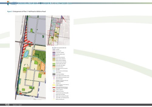
Figure 3: Enlargement of <strong>Plan</strong> 5 -Hall Road to Ballarto Road 10 Section 3 - Vision cranbourne west precinct structure plan
3.2 NEW COMMUNITY AND EMPLOYMENT STRUCTURE 3.2.1 BROAD LAND USE CONFIGURATION The <strong>Precinct</strong> consists of two principal land uses: residential and employment. The structure of the <strong>Precinct</strong> is determined by the need to achieve a dwelling yield sufficient to sustain core community infrastructure (i.e. schools, kindergartens, local social and health services, local shops and parks) and meet Melbourne 2030 expectations, whilst providing maximum employment land. Employment land uses are generally located in the north and west of the <strong>Precinct</strong>, whilst residential land uses are located in the east and south of the <strong>Precinct</strong>. Employment land uses generating higher job densities, such as offices, are located in the north-east of the <strong>Precinct</strong> toward Merinda Park Station, while lower job density land uses, such as distribution centres, are generally located in the southwest. A range of residential densities will be sought to respond to activity centres and the interface to the UGB. There are a number of reasons for this configuration of uses: • It locates residential development and other sensitive land uses away from existing poultry operations and the electricity terminal station in the north of the <strong>Precinct</strong>. • It maximises the length of new residential frontage along the Evans Road interface to the existing <strong>Cranbourne</strong> <strong>West</strong> community, and thereby facilitates integration of new residential development with the existing <strong>Cranbourne</strong> <strong>West</strong> community and shared use of supporting land uses such as activity centres, community facilities and schools. • It preserves land with higher landscape values in the south of the <strong>Precinct</strong> for ‘prestige’ residential development to encourage executives and senior managers to live locally. • It encourages transit-oriented development by locating the highest trip-generating land uses (i.e. offices, mixed use) near to public transport services at Merinda Park Station. • It locates employment land uses which generate a high proportion of heavy vehicle trips close to access points to <strong>West</strong>ern Port Highway. • It optimises the exposure for businesses to the <strong>West</strong>ern Port Highway, and minimises new residential frontages to its high traffic volumes. • It facilitates creation of a high quality business park and mixed use environment by encircling the Melbourne Water retarding basin on Evans Road with consistent land uses. • It manages interfaces between new residential development and employment land uses by locating complementary mixed use activities and public open spaces along the <strong>Precinct</strong>’s central internal spine. The future structure for urban development within the <strong>Precinct</strong> is shown in <strong>Plan</strong> 5. 3.2.2 INTEGRATED LIVING AND WORKING COMMUNITY Residential and employment areas will develop a distinct sense of character and image across the <strong>Precinct</strong>. However, a 2.4km interface between residential and employment land uses along the <strong>Precinct</strong>’s central internal spine presents an opportunity to knit the <strong>Precinct</strong> together into an integrated living and working community. The north south ‘employment interface’ punctuated by a series of eastwest pedestrian and road connections will enable direct access into employment areas by the workforce residing in the new residential development and the existing <strong>Cranbourne</strong> <strong>West</strong> community. In addition to strong connections across the <strong>Precinct</strong>, the central spine will have detailed design controls to manage built form integration, planned around a series of public open spaces along a boulevard style road, evolving into an adaptable mixed use corridor which provides transitional built form between residential neighbourhoods and larger scale industrial buildings. In this mixed use employment interface, Council envisages that the <strong>Precinct</strong> could accommodate a finer-grain style of commercial and industrial buildings catering for emerging professional and business support activities that will not adversely affect residential amenity. 3.2.3 GREEN WEB The <strong>Precinct</strong>’s ‘constructed’ agricultural landscape means little indigenous vegetation remains and its landscape characteristics are defined by mature windrows and gently undulating land dissected and shaped by drainage corridors. These landscape features form green infrastructure that provide a framework of natural assets that will shape land uses and connections within the <strong>Precinct</strong> and into the surrounding urban fabric and open space network. This green web will contribute to the <strong>Precinct</strong> creating a ‘city living, country feel’ for residents and workers through access to high quality, well located green spaces and will echo an important reminder of the pre-contact landscape as aspired by the local Aboriginal communities. Components of the green web are: • Drainage corridors and retarding basins. • Local and linear parks framed by existing and remnant windrows and copses. • An Aboriginal park. • Active public open space. • Green road verges. • Local high points and ridgelines. • View lines. 3.2.4 IMAGE AND CHARACTER The existing and previous agricultural use has removed most of the remnant indigenous vegetation from the <strong>Precinct</strong> leaving only scattered mature trees in pastures and roadsides and small, fragmented roadside patches of trees and shrubs, grasses and herbs. In developing the PSP, landscape cues have been taken from the topography, views and vistas, remnant vegetation, rural dams and drainage lines. Casey C21 and the Casey Image Strategy encourage a treed image for Casey and in particular <strong>Cranbourne</strong> <strong>West</strong>. They endorse extensive boulevard planting along the main road network. This includes boulevard planting across drainage lines to encourage views to the wide green spaces with informal indigenous plantings along water courses. The sandy soil conditions, particularly in the area south of Hall Road, will pose challenges to establishment of vegetation over time. This places additional significance on the retention of indigenous and nonindigenous vegetation within the development of the <strong>Precinct</strong> to help establish an image and character for the new communities from day one. They provide a sense of place and character for the residential area, allowing additional planting over time to grow, replace and then form the dominate character. Open space, community infrastructure and roads has been cognisant of these features and in many cases to incorporated them within public land, so that Council can build on the image and character of the new community over time. A tree reserve is required along the eastern side of <strong>West</strong>ern Port Highway to ensure the implementation of the Casey Arterial Roads Tree Strategy (CARTS). The purpose of this reservation is to facilitate a double row of tree planting along the Highway which assists with creating a legible and unified landscape character in Casey. This reserve has been implemented to the north of Thompsons Road in Lyndhurst and carrying it along the length of <strong>West</strong>ern Port Highway is highly desirable. Similarly, the implementation of CARTS on the other arterial roads will ensure a consistent landscape theme with existing residential areas. 3.2.5 HOUSING The establishment of an integrated and sustainable residential suburb by developing walkable neighbourhoods is a key element of the PSP. The configuration of residential development within the <strong>Precinct</strong> creates two walkable neighbourhoods – one north of Hall Road which includes part of the existing development east of Evans Road, and another south of Hall Road. cranbourne west precinct structure plan Section 3 - Vision 11