

Cranbourne West Precinct Structure Plan - Growth Areas Authority
Cranbourne West Precinct Structure Plan - Growth Areas Authority
Cranbourne West Precinct Structure Plan - Growth Areas Authority

You also want an ePaper? Increase the reach of your titles
YUMPU automatically turns print PDFs into web optimized ePapers that Google loves.
6<br />
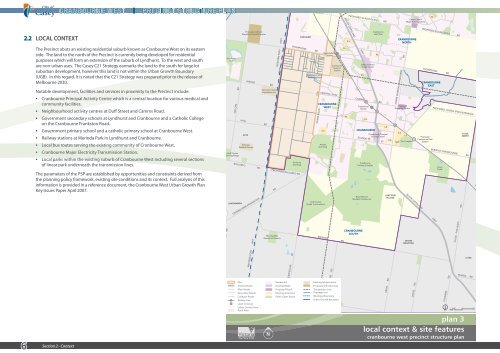
2.2 LOCAL CONTEXT<br />
The <strong>Precinct</strong> abuts an existing residential suburb known as <strong>Cranbourne</strong> Victorian Canine <strong>West</strong> on its eastern<br />
Association Inc.<br />
side. The land to the north of the <strong>Precinct</strong> is currently being developed for residential<br />
purposes which will form an extension of the suburb of Lyndhurst. To the west and south<br />
are non-urban uses. The Casey C21 Strategy earmarks the land to the south for large lot<br />
suburban development, however this land is not within the Urban <strong>Growth</strong> Boundary<br />
(UGB). In this regard, it is noted that the C21 Strategy was prepared prior to the release of<br />
Melbourne 2030.<br />
Notable development, facilities and services in proximity to the <strong>Precinct</strong> include:<br />
SKYE<br />
• <strong>Cranbourne</strong> Principal Activity Centre which is a central location for various medical and<br />
community facilities.<br />
Victorian<br />
Paintball Games<br />
• Neighbourhood activity centres at Duff Street and Camms Road.<br />
Skye Golf Course<br />
and Driving Range<br />
• Government secondary schools at Lyndhurst and <strong>Cranbourne</strong> and a Catholic College<br />
on the <strong>Cranbourne</strong> Frankston Road.<br />
• Government primary school and a catholic primary school at <strong>Cranbourne</strong> <strong>West</strong>.<br />
• Railway stations at Merinda Park in Lyndhurst and <strong>Cranbourne</strong>.<br />
• Local bus routes serving the existing community of <strong>Cranbourne</strong> <strong>West</strong>.<br />
• <strong>Cranbourne</strong> Major Electricity Transmission Station.<br />
• Local parks within the existing suburb of <strong>Cranbourne</strong> <strong>West</strong> including several sections<br />
LANGWARRIN<br />
of linear park underneath the transmission lines.<br />
The parameters of the PSP are established by opportunities and constraints derived from<br />
the planning policy framework, existing site conditions and its context. Full analysis of this<br />
information is provided in a reference document, the <strong>Cranbourne</strong> <strong>West</strong> Urban <strong>Growth</strong> <strong>Plan</strong><br />
Key Issues Paper April 2007.<br />
Section 2 - Context<br />
CENTRE RD<br />
Sandhurst<br />
Club<br />
TAYLORS RD<br />
WEDGE RD<br />
HALL RD<br />
MORNINGTON<br />
PENINSULA<br />
Ranfurlie<br />
Golf Club<br />
BALLARTO RD PROPOSED BALLARTO RD<br />
CRANBOURNE-FRANKSTON RD<br />
WESTERN PORT HWY<br />
WESTERN PORT HWY<br />
Morning Mist<br />
Recreation Reserve<br />
THOMPSONS RD<br />
PEARCEDALE RD<br />
Melbourne Water<br />
Retarding Basin<br />
EVANS ROAD<br />
CRANBOURNE<br />
WEST<br />
Amstel<br />
Golf Club<br />
Golf Course<br />
(Under Construction)<br />
NORTH RD<br />
MerindaPark<br />
Station<br />
CENTRAL PKW<br />
S.S.<br />
Sandhurst<br />
Club<br />
Skye Golf Course<br />
and Driving Range<br />
CENTRE RD<br />
<strong>Cranbourne</strong><br />
Terminal<br />
Station<br />
TAYLORS RD<br />
BROWNS RD<br />
SMITHS RD<br />
P.S.<br />
P.S.<br />
LANGWARRIN<br />
S.S.<br />
Propose Lyndhurst<br />
Electricity Terminal Station<br />
P.S.<br />
SKYE<br />
Victorian<br />
Paintball Games<br />
MORNINGTON<br />
PENINSULA<br />
S.S.<br />
Victorian Canine<br />
CRANBOURNE<br />
Association Inc.<br />
<strong>Cranbourne</strong> Principal<br />
Activity Centre<br />
P.S.<br />
P.S.<br />
HALL RD<br />
WESTERN PORT HWY<br />
HWY<br />
GLASSCOCKS RD<br />
<strong>Cranbourne</strong><br />
Station<br />
WEDGE RD<br />
Royal Botanic<br />
Gardens <strong>Cranbourne</strong><br />
WESTERN PORT HWY<br />
Morning Mist<br />
Recreation Reserve<br />
CRANBOURNE<br />
Lynbrook Station<br />
NORTH<br />
Ranfurlie<br />
Golf Club<br />
BALLARTO RD PROPOSED BALLARTO RD<br />
CRANBOURNE<br />
SOUTH<br />
CRANBOURNE-FRANKSTON RD<br />
Site<br />
Arterial Roads<br />
Main Roads<br />
Secondary Roads<br />
Collector Roads<br />
Railway Line<br />
Level Crossing<br />
Urban <strong>Growth</strong> Area<br />
Rural Area<br />
Great Southern<br />
Home Centre<br />
P.S.<br />
<strong>Cranbourne</strong><br />
Training Complex<br />
P.S.<br />
CAMMS RD<br />
SLADEN ST<br />
JUNCTION<br />
VILLAGE<br />
CRAIG RD<br />
LYNDHURST<br />
THOMPSONS RD<br />
NARRE WARREN-CRANBOURNE RD<br />
PEARCEDALE RD<br />
S.S.<br />
Residential<br />
Existing Retail<br />
Proposed Retail<br />
Existing Amenities<br />
Public Open Space<br />
Proposed<br />
Shopping Centre<br />
S.S.<br />
TAFE The Complex<br />
Melbourne Water<br />
Retarding Basin<br />
MerindaPark<br />
Station<br />
Proposed<br />
<strong>Cranbourne</strong> East<br />
Station<br />
CRANBOURNE<br />
WEST<br />
EVANS ROAD<br />
S.S.<br />
Amstel<br />
Golf Club<br />
DEVON Golf Course<br />
MEADOWS (Under Construction)<br />
NORTH RD<br />
CRANBOURNE<br />
EAST<br />
CENTRAL PKW<br />
SOUTH GIPPSLAND HWY<br />
CROSS RD<br />
THOMPSONS RD<br />
<strong>Cranbourne</strong><br />
Terminal<br />
Station<br />
BROWNS RD<br />
SMITHS RD<br />
Casey<br />
Fields<br />
<strong>Cranbourne</strong><br />
Golf Club<br />
P.S.<br />
P.S.<br />
PROPOSED GLASSCOCKS RD<br />
SOUTH GIPPSLAND HWY<br />
S.S.<br />
PROPOSED LINSELL BVD EXTENSION<br />
P.S.<br />
CLYDE<br />
NORTH<br />
BERWICK-CRANBOURNE RD<br />
Existing Infrastructure<br />
Proposed Infrastructure<br />
Transmission Line<br />
Drainage Line<br />
Municipal Boundary<br />
Urban <strong>Growth</strong> Boundary<br />
North<br />
<strong>Cranbourne</strong><br />
Station<br />
CRANBOURNE<br />
SOUTH<br />
FISHERIES RD CLYDE - FIVE WAYS RD<br />
Great Southern<br />
Home Centre<br />
P.S.<br />
CRANBOURNE<br />
<strong>Cranbourne</strong><br />
Training Complex<br />
Royal Botanic<br />
Gardens <strong>Cranbourne</strong><br />
Site<br />
Arterial Roads<br />
Main Roads<br />
Secondary Roads<br />
Collector Roads<br />
Railway Line<br />
Level Crossing<br />
Urban <strong>Growth</strong> Area<br />
Rural Area<br />
<strong>Cranbourne</strong><br />
Golf Club<br />
P.S.<br />
CAMMS RD<br />
P.S.<br />
S.S.<br />
<strong>Cranbourne</strong> Principal<br />
Activity Centre<br />
P.S.<br />
P.S.<br />
SLADEN ST<br />
CLYDE<br />
MANKS RD<br />
0 100 200 500 1000m<br />
JUNCTION<br />
VILLAGE<br />
CRAIG RD<br />
CRANBOURNE<br />
NORTH<br />
NARRE WARREN-CRANBOURNE RD<br />
Proposed<br />
Shopping Centre<br />
S.S.<br />
Residential<br />
Existing Retail<br />
Proposed Retail<br />
Existing Amenities<br />
Public Open Space<br />
S.S.<br />
TAFE The Complex<br />
Casey Central<br />
Major Activity Centre<br />
DEVON<br />
MEADOWS<br />
P.S.<br />
PROPOSED GLASSCOCKS RD<br />
THOMPSONS RD<br />
CRANBOURNE<br />
EAST<br />
Proposed<br />
<strong>Cranbourne</strong> East<br />
Station<br />
SOUTH GIPPSLAND HWY<br />
CROSS RD<br />
PROPOSED LINSELL BVD EXTENSION<br />
Casey<br />
Fields<br />
CLYDE<br />
NORTH<br />
BERWICK-CRANBOURNE RD<br />
Existing Infrastructure<br />
Proposed Infrastructure<br />
Transmission Line<br />
Drainage Line<br />
Municipal Boundary<br />
Urban <strong>Growth</strong> Boundary<br />
North<br />
FISHERIES RD CLYDE - FIVE WAYS RD<br />
CLYDE<br />
MANKS RD<br />
0 100 200 500 1000m<br />
plan 3<br />
local context & site features<br />
cranbourne west precinct structure plan


