Consolidated Environmental Management Plan for Burrard Inlet ...
Consolidated Environmental Management Plan for Burrard Inlet ...
Consolidated Environmental Management Plan for Burrard Inlet ...

Create successful ePaper yourself
Turn your PDF publications into a flip-book with our unique Google optimized e-Paper software.
Appendix 2: <strong>Burrard</strong> <strong>Inlet</strong> Physical<br />
Setting, Uses and Ecosystem<br />
30<br />
<strong>Consolidated</strong> <strong>Environmental</strong> <strong>Management</strong> <strong>Plan</strong> <strong>for</strong> <strong>Burrard</strong> <strong>Inlet</strong> / Appendices<br />
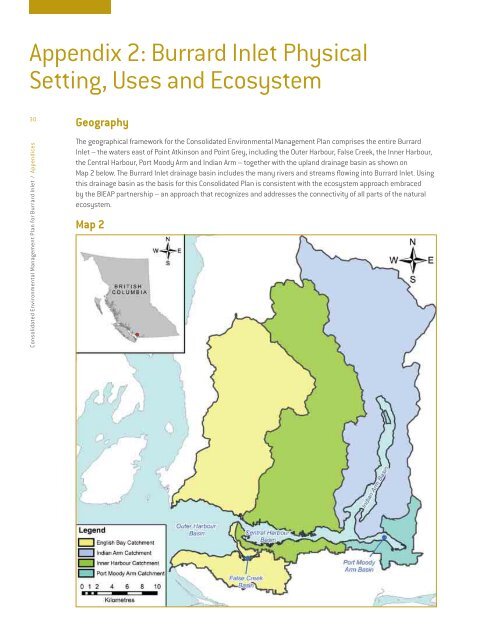
Geography<br />
The geographical framework <strong>for</strong> the <strong>Consolidated</strong> <strong>Environmental</strong> <strong>Management</strong> <strong>Plan</strong> comprises the entire <strong>Burrard</strong><br />
<strong>Inlet</strong> – the waters east of Point Atkinson and Point Grey, including the Outer Harbour, False Creek, the Inner Harbour,<br />
the Central Harbour, Port Moody Arm and Indian Arm – together with the upland drainage basin as shown on<br />
Map 2 below. The <strong>Burrard</strong> <strong>Inlet</strong> drainage basin includes the many rivers and streams fl owing into <strong>Burrard</strong> <strong>Inlet</strong>. Using<br />
this drainage basin as the basis <strong>for</strong> this <strong>Consolidated</strong> <strong>Plan</strong> is consistent with the ecosystem approach embraced<br />
by the BIEAP partnership – an approach that recognizes and addresses the connectivity of all parts of the natural<br />
ecosystem.<br />
Map 2