Data Specification on Orthoimagery – Draft ... - INSPIRE - Europa
Data Specification on Orthoimagery – Draft ... - INSPIRE - Europa
Data Specification on Orthoimagery – Draft ... - INSPIRE - Europa
You also want an ePaper? Increase the reach of your titles
YUMPU automatically turns print PDFs into web optimized ePapers that Google loves.
<strong>INSPIRE</strong> Reference: D2.8.II.3_v2.0<br />
TWG-OI <str<strong>on</strong>g>Data</str<strong>on</strong>g> <str<strong>on</strong>g>Specificati<strong>on</strong></str<strong>on</strong>g> <strong>on</strong> <strong>Orthoimagery</strong> 2011-06-15 Page 2<br />
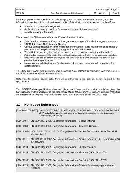
For the purposes of this specificati<strong>on</strong>, orthoimagery shall include orthorectified imagery from the<br />
infrared, through the visible, to the ultraviolet regi<strong>on</strong> of the electromagnetic spectrum derived from:<br />
• scanned film positives or negatives<br />
• digital airborne sensors (such as frame cameras or push-broom sensors)<br />
• satellite imagery of the Earth<br />
The scope of the <strong>Orthoimagery</strong> data specificati<strong>on</strong> does not include:<br />
• <str<strong>on</strong>g>Data</str<strong>on</strong>g> from the microwave, X-ray, radio or gamma ray areas of the electromagnetic spectrum.<br />
• LiDAR data (Light Detecti<strong>on</strong> And Ranging)<br />
• Oblique aerial photography (since this is not orthorectified). Note that orthorectified imagery<br />
produced from oblique photography - e.g. as a mosaic - is included.<br />
• Terrestrial imagery (e.g. from cameras based <strong>on</strong> the ground or <strong>on</strong> road or rail vehicles).<br />
• Aerial video imagery. Note that orthorectified images created from video frames is included.<br />
• Imagery of the sea bed from underwater sensors (<strong>on</strong>ly air-borne and satellite sensors are<br />
covered by the specificati<strong>on</strong>).<br />
• Meteorological satellite imagery (such data is not primarily c<strong>on</strong>cerned with imagery of the<br />
Earth’s surface).<br />
This does not prevent data providers from delivering such datasets in c<strong>on</strong>formity with this <strong>INSPIRE</strong><br />
data specificati<strong>on</strong> if they feel the need to do so.<br />
Note that the original source data, from which orthoimages are derived, is not covered by the<br />
specificati<strong>on</strong>.<br />
This <strong>INSPIRE</strong> data specificati<strong>on</strong> does not place restricti<strong>on</strong>s <strong>on</strong> the spatial resoluti<strong>on</strong> given the<br />
heterogeneity of data sources and the wide range of use cases across Europe. All levels of resoluti<strong>on</strong><br />
are affected: the European level, the Nati<strong>on</strong>al level, the Regi<strong>on</strong>al level and the Local level.<br />
2.3 Normative References<br />
[Directive 2007/2/EC] Directive 2007/2/EC of the European Parliament and of the Council of 14 March<br />
2007 establishing an Infrastructure for Spatial Informati<strong>on</strong> in the European<br />
Community (<strong>INSPIRE</strong>)<br />
[ISO 19107] EN ISO 19107:2005, Geographic Informati<strong>on</strong> <strong>–</strong> Spatial Schema<br />
[ISO 19108] EN ISO 19108:2005, Geographic Informati<strong>on</strong> <strong>–</strong> Temporal Schema<br />
[ISO 19108-c] ISO 19108:2002/Cor 1:2006, Geographic Informati<strong>on</strong> <strong>–</strong> Temporal Schema, Technical<br />
Corrigendum 1<br />
[ISO 19111] EN ISO 19111:2007 Geographic informati<strong>on</strong> - Spatial referencing by coordinates (ISO<br />
19111:2007)<br />
[ISO 19113] EN ISO 19113:2005, Geographic Informati<strong>on</strong> <strong>–</strong> Quality principles<br />
[ISO 19115] EN ISO 19115:2005, Geographic informati<strong>on</strong> <strong>–</strong> Metadata (ISO 19115:2003)<br />
[ISO 19118] EN ISO 19118:2006, Geographic informati<strong>on</strong> <strong>–</strong> Encoding (ISO 19118:2005)<br />
[ISO 19123] EN ISO 19123:2007, Geographic Informati<strong>on</strong> <strong>–</strong> Schema for coverage geometry and<br />
functi<strong>on</strong>s


