Data Specification on Orthoimagery – Draft ... - INSPIRE - Europa
Data Specification on Orthoimagery – Draft ... - INSPIRE - Europa
Data Specification on Orthoimagery – Draft ... - INSPIRE - Europa

Create successful ePaper yourself
Turn your PDF publications into a flip-book with our unique Google optimized e-Paper software.
<strong>INSPIRE</strong> Reference: D2.8.II.3_v2.0<br />
TWG-OI <str<strong>on</strong>g>Data</str<strong>on</strong>g> <str<strong>on</strong>g>Specificati<strong>on</strong></str<strong>on</strong>g> <strong>on</strong> <strong>Orthoimagery</strong> 2011-06-15 Page 18<br />
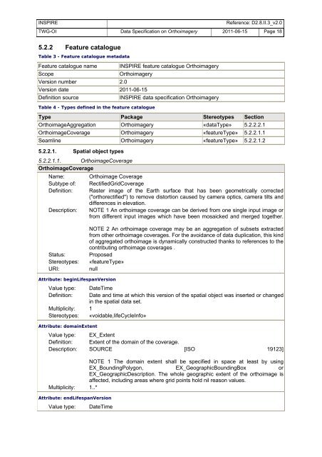
5.2.2 Feature catalogue<br />
Table 3 - Feature catalogue metadata<br />
Feature catalogue name <strong>INSPIRE</strong> feature catalogue <strong>Orthoimagery</strong><br />
Scope <strong>Orthoimagery</strong><br />
Versi<strong>on</strong> number 2.0<br />
Versi<strong>on</strong> date 2011-06-15<br />
Definiti<strong>on</strong> source <strong>INSPIRE</strong> data specificati<strong>on</strong> <strong>Orthoimagery</strong><br />
Table 4 - Types defined in the feature catalogue<br />
Type Package Stereotypes Secti<strong>on</strong><br />
OrthoimageAggregati<strong>on</strong> <strong>Orthoimagery</strong> «dataType» 5.2.2.2.1<br />
OrthoimageCoverage <strong>Orthoimagery</strong> «featureType» 5.2.2.1.1<br />
Seamline <strong>Orthoimagery</strong> «featureType» 5.2.2.1.2<br />
5.2.2.1. Spatial object types<br />
5.2.2.1.1. OrthoimageCoverage<br />
OrthoimageCoverage<br />
Name: Orthoimage Coverage<br />
Subtype of: RectifiedGridCoverage<br />
Definiti<strong>on</strong>: Raster image of the Earth surface that has been geometrically corrected<br />
("orthorectified") to remove distorti<strong>on</strong> caused by camera optics, camera tilts and<br />
differences in elevati<strong>on</strong>.<br />
Descripti<strong>on</strong>: NOTE 1 An orthoimage coverage can be derived from <strong>on</strong>e single input image or<br />
from different input images which have been mosaicked and merged together.<br />
NOTE 2 An orthoimage coverage may be an aggregati<strong>on</strong> of subsets extracted<br />
from other orthoimage coverages. For the avoidance of data duplicati<strong>on</strong>, this kind<br />
of aggregated orthoimage is dynamically c<strong>on</strong>structed thanks to references to the<br />
c<strong>on</strong>tributing orthoimage coverages .<br />
Status: Proposed<br />
Stereotypes: «featureType»<br />
URI: null<br />
Attribute: beginLifespanVersi<strong>on</strong><br />
Value type: DateTime<br />
Definiti<strong>on</strong>: Date and time at which this versi<strong>on</strong> of the spatial object was inserted or changed<br />
in the spatial data set.<br />
Multiplicity: 1<br />
Stereotypes: «voidable,lifeCycleInfo»<br />
Attribute: domainExtent<br />
Value type: EX_Extent<br />
Definiti<strong>on</strong>: Extent of the domain of the coverage.<br />
Descripti<strong>on</strong>: SOURCE [ISO 19123]<br />
NOTE 1 The domain extent shall be specified in space at least by using<br />
EX_BoundingPolyg<strong>on</strong>, EX_GeographicBoundingBox or<br />
EX_GeographicDescripti<strong>on</strong>. The whole geographic extent of the orthoimage is<br />
affected, including areas where grid points hold nil reas<strong>on</strong> values.<br />
Multiplicity: 1..*<br />
Attribute: endLifespanVersi<strong>on</strong><br />
Value type: DateTime