Data Specification on Orthoimagery – Draft ... - INSPIRE - Europa
Data Specification on Orthoimagery – Draft ... - INSPIRE - Europa
Data Specification on Orthoimagery – Draft ... - INSPIRE - Europa

Create successful ePaper yourself
Turn your PDF publications into a flip-book with our unique Google optimized e-Paper software.
<strong>INSPIRE</strong> Reference: D2.8.II.3_v2.0<br />
TWG-OI <str<strong>on</strong>g>Data</str<strong>on</strong>g> <str<strong>on</strong>g>Specificati<strong>on</strong></str<strong>on</strong>g> <strong>on</strong> <strong>Orthoimagery</strong> 2011-06-15 Page 58<br />
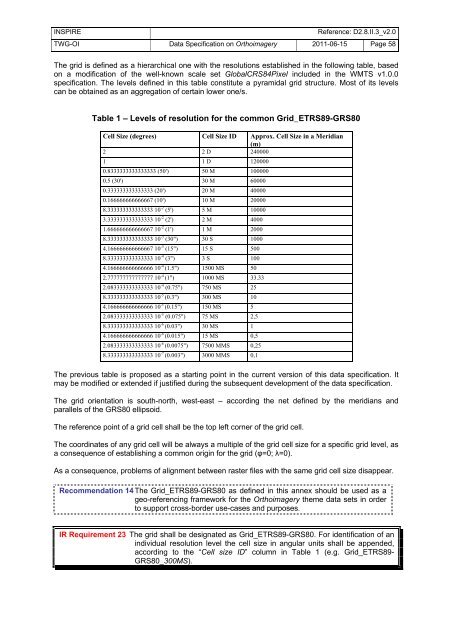
The grid is defined as a hierarchical <strong>on</strong>e with the resoluti<strong>on</strong>s established in the following table, based<br />
<strong>on</strong> a modificati<strong>on</strong> of the well-known scale set GlobalCRS84Pixel included in the WMTS v1.0.0<br />
specificati<strong>on</strong>. The levels defined in this table c<strong>on</strong>stitute a pyramidal grid structure. Most of its levels<br />
can be obtained as an aggregati<strong>on</strong> of certain lower <strong>on</strong>e/s.<br />
Table 1 <strong>–</strong> Levels of resoluti<strong>on</strong> for the comm<strong>on</strong> Grid_ETRS89-GRS80<br />
Cell Size (degrees) Cell Size ID Approx. Cell Size in a Meridian<br />
(m)<br />
2 2 D 240000<br />
1 1 D 120000<br />
0.8333333333333333 (50') 50 M 100000<br />
0.5 (30') 30 M 60000<br />
0.333333333333333 (20') 20 M 40000<br />
0.166666666666667 (10') 10 M 20000<br />
8.333333333333333 10 -2 (5') 5 M 10000<br />
3.333333333333333 10 -2 (2') 2 M 4000<br />
1.666666666666667 10 -2 (1') 1 M 2000<br />
8.333333333333333 10 -3 (30") 30 S 1000<br />
4.166666666666667 10 -3 (15") 15 S 500<br />
8.333333333333333 10 -4 (3") 3 S 100<br />
4.166666666666666 10 -4 (1.5") 1500 MS 50<br />
2.777777777777777 10 -4 (1") 1000 MS 33.33<br />
2.083333333333333 10 -4 (0.75") 750 MS 25<br />
8.333333333333333 10 -5 (0.3") 300 MS 10<br />
4.166666666666666 10 -5 (0.15") 150 MS 5<br />
2.083333333333333 10 -5 (0.075") 75 MS 2,5<br />
8.333333333333333 10 -6 (0.03") 30 MS 1<br />
4.166666666666666 10 -6 (0.015") 15 MS 0,5<br />
2.083333333333333 10 -6 (0.0075") 7500 MMS 0,25<br />
8.333333333333333 10 -7 (0.003") 3000 MMS 0,1<br />
The previous table is proposed as a starting point in the current versi<strong>on</strong> of this data specificati<strong>on</strong>. It<br />
may be modified or extended if justified during the subsequent development of the data specificati<strong>on</strong>.<br />
The grid orientati<strong>on</strong> is south-north, west-east <strong>–</strong> according the net defined by the meridians and<br />
parallels of the GRS80 ellipsoid.<br />
The reference point of a grid cell shall be the top left corner of the grid cell.<br />
The coordinates of any grid cell will be always a multiple of the grid cell size for a specific grid level, as<br />
a c<strong>on</strong>sequence of establishing a comm<strong>on</strong> origin for the grid (φ=0; λ=0).<br />
As a c<strong>on</strong>sequence, problems of alignment between raster files with the same grid cell size disappear.<br />
Recommendati<strong>on</strong> 14 The Grid_ETRS89-GRS80 as defined in this annex should be used as a<br />
geo-referencing framework for the <strong>Orthoimagery</strong> theme data sets in order<br />
to support cross-border use-cases and purposes.<br />
IR Requirement 23 The grid shall be designated as Grid_ETRS89-GRS80. For identificati<strong>on</strong> of an<br />
individual resoluti<strong>on</strong> level the cell size in angular units shall be appended,<br />
according to the “Cell size ID” column in Table 1 (e.g. Grid_ETRS89-<br />
GRS80_300MS).