Data Specification on Orthoimagery – Draft ... - INSPIRE - Europa
Data Specification on Orthoimagery – Draft ... - INSPIRE - Europa
Data Specification on Orthoimagery – Draft ... - INSPIRE - Europa

Create successful ePaper yourself
Turn your PDF publications into a flip-book with our unique Google optimized e-Paper software.
<strong>INSPIRE</strong> Reference: D2.8.II.3_v2.0<br />
TWG-OI <str<strong>on</strong>g>Data</str<strong>on</strong>g> <str<strong>on</strong>g>Specificati<strong>on</strong></str<strong>on</strong>g> <strong>on</strong> <strong>Orthoimagery</strong> 2011-06-15 Page 50<br />
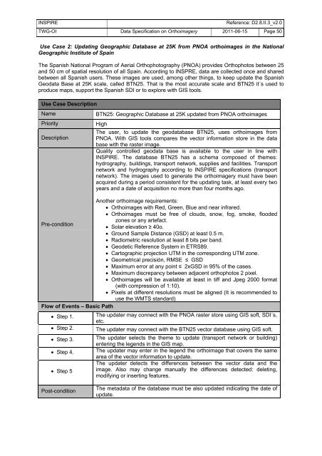
Use Case 2: Updating Geographic <str<strong>on</strong>g>Data</str<strong>on</strong>g>base at 25K from PNOA orthoimages in the Nati<strong>on</strong>al<br />
Geographic Institute of Spain<br />
The Spanish Nati<strong>on</strong>al Program of Aerial Orthophotography (PNOA) provides Orthophotos between 25<br />
and 50 cm of spatial resoluti<strong>on</strong> of all Spain. According to INSPRE, data are collected <strong>on</strong>ce and shared<br />
between all Spanish users. These images are used, am<strong>on</strong>g other things, to keep update the Spanish<br />
Geodata Base at 25K scale, called BTN25. That is the most accurate scale and BTN25 it´s used to<br />
produce maps, support the Spanish SDI or to explore with GIS tools.<br />
Use Case Descripti<strong>on</strong><br />
Name BTN25: Geographic <str<strong>on</strong>g>Data</str<strong>on</strong>g>base at 25K updated from PNOA orthoimages<br />
Priority High<br />
The user, to update the geodatabase BTN25, uses orthoimages from<br />
Descripti<strong>on</strong><br />
PNOA. With GIS tools compares the vector informati<strong>on</strong> store in the data<br />
base with the raster image.<br />
Quality c<strong>on</strong>trolled geodata base is available to the user in line with<br />
<strong>INSPIRE</strong>. The database BTN25 has a schema composed of themes:<br />
hydrography, buildings, transport network, supplies and facilities. Transport<br />
network and hydrography according to <strong>INSPIRE</strong> specificati<strong>on</strong>s (transport<br />
network). The images used to generate the orthoimagery must have been<br />
acquired during a period c<strong>on</strong>sistent for the updating task, at least every two<br />
years and a date of acquisiti<strong>on</strong> no more than four m<strong>on</strong>ths ago.<br />
Another orthoimage requirements:<br />
• Orthoimages with Red, Green, Blue and near infrared.<br />
• Orthoimages must be free of clouds, snow, fog, smoke, flooded<br />
z<strong>on</strong>es or any artefact.<br />
Pre-c<strong>on</strong>diti<strong>on</strong><br />
• Solar elevati<strong>on</strong> ≥ 40o.<br />
• Ground Sample Distance (GSD) at least 0.5 m.<br />
• Radiometric resoluti<strong>on</strong> at least 8 bits per band.<br />
• Geodetic Reference System in ETRS89.<br />
• Cartographic projecti<strong>on</strong> UTM in the corresp<strong>on</strong>ding UTM z<strong>on</strong>e.<br />
• Geometrical precisión, RMSE ≤ GSD<br />
• Maximum error at any point ≤ 2xGSD in 95% of the cases.<br />
• Maximum discrepancy between adjacent orthophotos 2 pixel.<br />
• Orthoimages will be available at least in tiff and Jpeg 2000 format<br />
(with compressi<strong>on</strong> of 1:10).<br />
• Pixels at different resoluti<strong>on</strong>s must be aligned (It is recommended to<br />
use the WMTS standard)<br />
Flow of Events <strong>–</strong> Basic Path<br />
• Step 1. The updater may c<strong>on</strong>nect with the PNOA raster store using GIS soft, SDI´s,<br />
etc.<br />
• Step 2. The updater may c<strong>on</strong>nect with the BTN25 vector database using GIS soft.<br />
• Step 3. The updater selects the theme to update (transport network or building)<br />
entering the legends in the GIS map.<br />
• Step 4. The updater may enter in the legend the orthoimage that covers the same<br />
• Step 5<br />
Post-c<strong>on</strong>diti<strong>on</strong><br />
area of the vector informati<strong>on</strong> to update.<br />
The updater detects the differences between the vector data and the<br />
image. Also may change manually the differences detected: deleting,<br />
modifying or inserting features.<br />
The metadata of the database must be also updated indicating the date of<br />
update.