The Hengill Geothermal System, Conceptual Model and Thermal ...
The Hengill Geothermal System, Conceptual Model and Thermal ...
The Hengill Geothermal System, Conceptual Model and Thermal ...

Create successful ePaper yourself
Turn your PDF publications into a flip-book with our unique Google optimized e-Paper software.
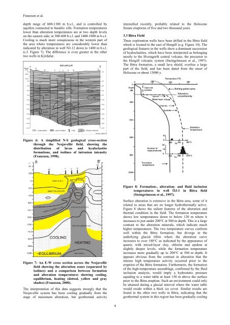
Franzson et al.<br />
depth range of 600-1100 m b.s.l., <strong>and</strong> is controlled by<br />
aquifers connected to basaltic sills. Formation temperatures<br />
lower than alteration temperatures are at two depth levels<br />
on the eastern side; at 300-600 b.s.l. <strong>and</strong> 1400-1900 m b.s.l.<br />
Cooling is much more conspicuous in the western part of<br />
the area where temperatures are considerably lower than<br />
indicated by alteration in well NJ-12 down to 1400 m b.s.l.<br />
(c.f. Figure 7). <strong>The</strong> difference is even greater in the other<br />
two wells in Kýrdalur.<br />
intensified recently, probably related to the Holocene<br />
fissure eruptions of five <strong>and</strong> two thous<strong>and</strong> years.<br />
3.3 Bitra Field<br />
Three exploration wells have been drilled in the Bitra field<br />
which is located to the east of <strong>Hengill</strong> (e.g. Figure 14). <strong>The</strong><br />
geological features in the wells show a dominant succession<br />
of hyaloclastites, which have been interpreted as belonging<br />
mostly to the Hveragerði central volcano, the precursor to<br />
the <strong>Hengill</strong> volcanic system (Steingrímsson et al., 1997).<br />
<strong>The</strong> Bitra formation, a small lava shield, overlies a large<br />
part of the field, <strong>and</strong> has been dated from the onset of<br />
Holocene or about 13000 y.<br />
Figure 6: A simplified N-S geological cross-section<br />
through the Nesjavellir field, showing the<br />
distribution of lavas <strong>and</strong> hyaloclastite<br />
formations, <strong>and</strong> isolines of intrusion intensity<br />
(Franzson, 1998).<br />
Figure 7: An E-W cross section across the Nesjavellir<br />
field showing the alteration zones (separated by<br />
isolines) <strong>and</strong> a comparison between formation<br />
<strong>and</strong> alteration temperatures showing cooling,<br />
equilibrium, heating (dotted, yellow <strong>and</strong> gray<br />
shades) (Franzson, 2000).<br />
<strong>The</strong> interpretation of this data suggests strongly that the<br />
Nesjavellir system has been cooling gradually from the<br />
stage of maximum alteration, but geothermal activity<br />
Figure 8: Formation-, alteration- <strong>and</strong> fluid inclusion<br />
temperatures in well ÖJ-1 in Bitra field<br />
(Steingrímsson et al., 1997).<br />
Surface alteration is extensive in the Bitra area, some of it<br />
related to areas that are no longer hydrothermally active.<br />
Figure 8 shows the salient features of the alteration <strong>and</strong><br />
thermal condition in the field. <strong>The</strong> formation temperature<br />
shows low temperatures down to below 120 m where it<br />
increases to just under 200°C at 500 m depth. This is a large<br />
contrast to the alteration minerals, which indicate much<br />
higher temperatures. <strong>The</strong> two temperature curves conform<br />
well within the Bitra formation, but diverge in the<br />
underlying glacial tillite where the alteration curve<br />
increases to over 180°C as indicated by the appearance of<br />
quartz, with mixed-layer clay, chlorite <strong>and</strong> epidote at<br />
slightly deeper levels, while the formation temperature<br />
increases more gradually up to 200°C at 500 m depth. It<br />
appears obvious from the contrast in alteration that the<br />
intense high temperature activity occurred prior to the<br />
eruption of the Bitra formation. Furthermore, the formation<br />
of the high-temperature assemblage, confirmed by the fluid<br />
inclusion analysis, would imply a hydrostatic pressure<br />
equaling to a water table at least 150 m above the surface<br />
prior to the Bitra eruption. Such an environment could only<br />
be attained during a glacial interval where the water table<br />
would reside within a thick ice cover. Similar results are<br />
found in the other two wells in Bitra, indicating that the<br />
geothermal system in this region has been gradually cooling<br />
4