The Continental Intercalaire Aquifer at the Kébili Geothermal Field ...
The Continental Intercalaire Aquifer at the Kébili Geothermal Field ...
The Continental Intercalaire Aquifer at the Kébili Geothermal Field ...

Create successful ePaper yourself
Turn your PDF publications into a flip-book with our unique Google optimized e-Paper software.
Proceedings World Geo<strong>the</strong>rmal Congress 2005<br />
Antalya, Turkey, 24-29 April 2005<br />
<strong>The</strong> <strong>Continental</strong> <strong>Intercalaire</strong> <strong>Aquifer</strong> <strong>at</strong> <strong>the</strong> <strong>Kébili</strong> Geo<strong>the</strong>rmal <strong>Field</strong>, Sou<strong>the</strong>rn Tunisia<br />
Aissa Agoun<br />
Regional Commissari<strong>at</strong> for Agricultural Development W<strong>at</strong>er Resources Departement, C.R.D.A <strong>Kébili</strong>, <strong>Kébili</strong> 4200, TUNISIA<br />
aissa_2503@yahoo.fr<br />
Keywords: CI, <strong>Kébili</strong>, wells, artesian<br />
ABSTRACT<br />
<strong>The</strong> C.I. "<strong>Continental</strong> <strong>Intercalaire</strong>" aquifer is an extensive<br />
horizontal sandstone reservoir (Neocomien: Lower<br />
Cretaceous: Purbecko-Wealdien). <strong>The</strong> CI is one of <strong>the</strong><br />
largest aquifers in <strong>the</strong> world covering more than 1 million<br />
km 2 in Tunisia, Algeria and Libya. This aquifer covers<br />
80,000 km 2 in Tunisia<br />
In <strong>Kébili</strong> field in sou<strong>the</strong>rn Tunisia, <strong>the</strong> geo<strong>the</strong>rmal w<strong>at</strong>er is<br />
about 25 to 50 thousand years old and of sulph<strong>at</strong>e chlorite<br />
type. <strong>The</strong> depth of <strong>the</strong> reservoir ranges from 1000 to 2800<br />
m.<br />
<strong>The</strong> piézométric level is about 200 meters above <strong>the</strong><br />
wellhead. <strong>The</strong> flow r<strong>at</strong>e ranges from 70 to 200 l/s with a<br />
temper<strong>at</strong>ure th<strong>at</strong> exceeds 60°C. Approxim<strong>at</strong>ely 95% of <strong>the</strong><br />
geo<strong>the</strong>rmal w<strong>at</strong>er is used for irrig<strong>at</strong>ion of oases after<br />
cooling by <strong>at</strong>mospheric towers. Partly it is used for he<strong>at</strong>ing<br />
greenhouses. Most problems are encountered during <strong>the</strong> hot<br />
w<strong>at</strong>er utiliz<strong>at</strong>ion, such as scaling in <strong>the</strong> pipes, corrosion of<br />
anchor casing and in some parts of wellheads like valves<br />
and monitoring points. Ano<strong>the</strong>r problem is drawdown of<br />
<strong>the</strong> w<strong>at</strong>er level due to <strong>the</strong> <strong>the</strong> increasing w<strong>at</strong>er demands and<br />
saliniz<strong>at</strong>ion by intrusion of salt w<strong>at</strong>er from Chotts.<br />
1. INTRODUCTION<br />
<strong>The</strong> <strong>Continental</strong> <strong>Intercalaire</strong> (C.I.) fossil aquifer, which is<br />
composed of upper Carboniferous to Lower Cretaceous<br />
sandstone, is present bene<strong>at</strong>h an area of 1 Million km 2 in<br />
Tunisia (80,000), Algeria (700,000) and Libya (250,000). It<br />
constitutes one of <strong>the</strong> largest groundw<strong>at</strong>er systems in <strong>the</strong><br />
world. <strong>The</strong> huge groundw<strong>at</strong>er reservoir is mainly confined<br />
to <strong>the</strong> continental form<strong>at</strong>ions of <strong>the</strong> lower cretaceous<br />
(Neocomian, Barremian, Albo-aptien). In Tunisia, <strong>the</strong><br />
reservoir covers <strong>the</strong> regions of <strong>Kébili</strong>, Tozeur, Gabes and<br />
<strong>the</strong> extreme south. <strong>The</strong> most important production takes<br />
place <strong>at</strong> <strong>the</strong> <strong>Kébili</strong> geo<strong>the</strong>rmal field, where <strong>the</strong> depth to <strong>the</strong><br />
top of <strong>the</strong> reservoir varies from 600 to 2,800 m. Well<br />
pressures correspond to 200 metres above wellhead with<br />
temper<strong>at</strong>ure of around 70°C. <strong>The</strong> main utiliz<strong>at</strong>ion of<br />
geo<strong>the</strong>rmal w<strong>at</strong>er in <strong>Kébili</strong> geo<strong>the</strong>rmal field is for<br />
agriculture purposes; to help irrig<strong>at</strong>e oases, to he<strong>at</strong> and<br />
irrig<strong>at</strong>e greenhouses, for b<strong>at</strong>hing and in some cases for<br />
animals' consumption. <strong>The</strong> hot w<strong>at</strong>er needs to be extracted<br />
by deep wells and cooling through a cooling tower is<br />
necessary. Offsetting <strong>the</strong> growing need for using<br />
geo<strong>the</strong>rmal w<strong>at</strong>er for irrig<strong>at</strong>ion, <strong>the</strong>re are several problems<br />
encountered during exploit<strong>at</strong>ion such as scaling in <strong>the</strong><br />
pipes, corrosion of anchor casing and some parts of<br />
wellheads like valves and monitoring points. Also<br />
drawdown of <strong>the</strong> w<strong>at</strong>er level has been observed due to <strong>the</strong><br />
increasing w<strong>at</strong>er demands. Radiocarbon analysis has shown<br />
th<strong>at</strong> radiocarbon is present <strong>at</strong> between 2 and 10 pmc which<br />
leads to <strong>the</strong> conclusion th<strong>at</strong> <strong>the</strong> w<strong>at</strong>er is recharged during<br />
<strong>the</strong> l<strong>at</strong>e Pleistocene 25,000 years B.P, corresponding to <strong>the</strong><br />
last glaci<strong>at</strong>ion (Edmonds et al., 1997). W<strong>at</strong>er is fossil and<br />
without actual recharge, so to preserve <strong>the</strong> trans-borderers<br />
reservoir, more research must be carried out on <strong>the</strong> aquifer.<br />
Full collabor<strong>at</strong>ion with Algerian and Libyan organiz<strong>at</strong>ions<br />
is necessary in order to achieve economical and sustainable<br />
future production and regional development. Long term<br />
monitoring of pressure temper<strong>at</strong>ure and salinity <strong>at</strong> <strong>the</strong><br />
wellhead for each production well should be carried out.<br />
Any increase of drawdown during <strong>the</strong> next 20 years caused<br />
by increased production will lead to environmental changes.<br />
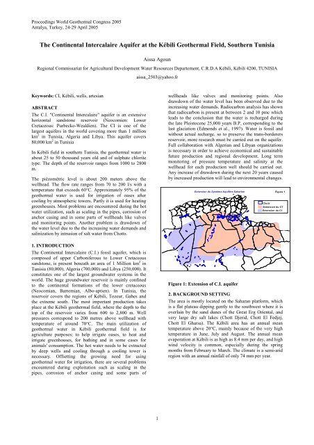
Extension du Système Aquifère Saharien<br />
Figure 1: Extension of C.I. aquifer<br />
Figure 1<br />
Chott<br />
Extension du CT<br />
Extension du CI<br />
2. BACKGROUND SETTING<br />
<strong>The</strong> area is mostly loc<strong>at</strong>ed on <strong>the</strong> Saharan pl<strong>at</strong>form, which<br />
is a fl<strong>at</strong> pl<strong>at</strong>eau dipping gently to <strong>the</strong> southwest where it is<br />
overlain by <strong>the</strong> sand dunes of <strong>the</strong> Gre<strong>at</strong> Erg Oriental, and<br />
very large dry salt lakes (Chott Djerid, Chott El Fedjej,<br />
Chott El Gharsa). <strong>The</strong> <strong>Kébili</strong> area has an annual mean<br />
temper<strong>at</strong>ure above 20°C, mainly because of <strong>the</strong> very high<br />
temper<strong>at</strong>ure in June, July and August. <strong>The</strong> annual mean<br />
evapor<strong>at</strong>ion <strong>at</strong> <strong>Kébili</strong> is as high as 8.4 mm per day, and high<br />
wind velocity is common, especially during <strong>the</strong> spring<br />
months from February to March. <strong>The</strong> clim<strong>at</strong>e is a semi-arid<br />
region with an annual rainfall of only 74 mm per year.<br />
1
Agoun<br />
Figure 2: Loc<strong>at</strong>ion map of <strong>Kébili</strong> geo<strong>the</strong>rmal field<br />
Figure 3: Geological map of aquifer system<br />
2.1 Geological Setting<br />
<strong>The</strong> huge groundw<strong>at</strong>er reservoir of <strong>Continental</strong> <strong>Intercalaire</strong><br />
(C.I.) aquifer is contained within <strong>the</strong> continental form<strong>at</strong>ions<br />
of lower Cretaceous Hautervien Valanginien (Neocomian,<br />
Barremian, Albian). It corresponds to <strong>the</strong> Asfer form<strong>at</strong>ion<br />
which is made up of interbedded varicolored clay or shale,<br />
sandstone, and small quantities of limestone, dolomite and<br />
evapor<strong>at</strong>es, and it is marked by presence of lignite<br />
(Castany, 1982). <strong>The</strong> C.I. aquifer consists of several<br />
horizons with different permeability and different form<strong>at</strong>ion<br />
pressures. <strong>The</strong> main reservoir horizon is <strong>the</strong> deepest one; it<br />
is reached by <strong>the</strong> main wells.<br />
<strong>Kébili</strong> is a very large region, but <strong>the</strong> sand of <strong>the</strong> Gre<strong>at</strong> Erg<br />
Oriental desert covers more than half of <strong>the</strong> area, and <strong>the</strong><br />
lakes Chott El Djerid and Chott El Fedjjej occupy<br />
considerable areas in <strong>the</strong> northwest and north. Thus, <strong>the</strong><br />
area of human activity in this province is limited to a small<br />
zone along <strong>the</strong> eastern shore of Chott El Djerid, which is<br />
2
Agoun<br />
slightly hilly country forming a kind of peninsula or island<br />
in <strong>the</strong> chott.<br />
2.2 Hydrogeology<br />
Where <strong>the</strong> <strong>Kébili</strong> geo<strong>the</strong>rmal field is loc<strong>at</strong>ed, <strong>the</strong> artesian<br />
flow r<strong>at</strong>e is usually higher than in <strong>the</strong> o<strong>the</strong>r provinces. <strong>The</strong><br />
geo<strong>the</strong>rmal gradient is approxim<strong>at</strong>ely from 29 to 35°C/km<br />
and increases from south to north. <strong>The</strong>re are three main<br />
aquifers in this region, <strong>the</strong> <strong>Continental</strong> <strong>Intercalaire</strong> and<br />
secondary aquifers within <strong>the</strong> Jurassic and <strong>the</strong> Permian. <strong>The</strong><br />
<strong>Continental</strong> <strong>Intercalaire</strong> aquifer covers <strong>the</strong> regions of<br />
<strong>Kébili</strong>, Tozeur, Gabes and <strong>the</strong> extreme south and extends to<br />
Algeria and Libya. It is characterized by temper<strong>at</strong>ures<br />
ranging from 35°C to 75°C, pressures of 14 - 22 bars and<br />
salinity of 2.2 - 4.2 g/l. <strong>The</strong> geo<strong>the</strong>rmal resource potential<br />
in <strong>the</strong> <strong>Kébili</strong> geo<strong>the</strong>rmal field is estim<strong>at</strong>ed to be 1,000 l/s<br />
(ERESS project, 1972).<br />
<strong>The</strong> principal areas of current or former recharge are in <strong>the</strong><br />
South Atlas Mountains of Algeria and Tunisia, <strong>the</strong> Tinrhet<br />
Pl<strong>at</strong>eau of Algeria and <strong>the</strong> Dahar Mountains of Tunisia. <strong>The</strong><br />
main discharge area is in Tunisia, in <strong>the</strong> Chotts and <strong>the</strong> Golf<br />
of Gabes. <strong>The</strong> C.I. aquifer is one of <strong>the</strong> largest confined<br />
aquifers in <strong>the</strong> world, comparable in scale to <strong>the</strong> Gre<strong>at</strong><br />
Artesian Basin of Australia and covers some 600,000 km 2 .<br />
3. MAIN UTILIZATION OF CONTINENTAL<br />
INTERCALAIRE GEOTHERMAL WATER<br />
In <strong>the</strong> <strong>Kébili</strong> region and <strong>the</strong> areas fur<strong>the</strong>r to <strong>the</strong> south <strong>the</strong>re<br />
are 24 wells reaching <strong>the</strong> different layers of <strong>the</strong> C.I. aquifer.<br />
<strong>The</strong>y are used to supply <strong>the</strong> oases with w<strong>at</strong>er for irrig<strong>at</strong>ion<br />
after cooling in cooling towers. <strong>The</strong> geo<strong>the</strong>rmal w<strong>at</strong>er is<br />
also used for <strong>the</strong> he<strong>at</strong>ing and irrig<strong>at</strong>ion of greenhouses.<br />
Fur<strong>the</strong>rmore, in <strong>the</strong> Douz region geo<strong>the</strong>rmal w<strong>at</strong>er is used<br />
for <strong>the</strong> he<strong>at</strong>ing of two swimming pools and several public<br />
b<strong>at</strong>hhouses. In both cases <strong>the</strong> return w<strong>at</strong>er is used for<br />
irrig<strong>at</strong>ing <strong>the</strong> surrounding oases (Ben Mohamed, 1997).<br />
15 - 40 m below <strong>the</strong> ground in <strong>the</strong> extreme south of Tunisia.<br />
<strong>The</strong> evalu<strong>at</strong>ion and management of w<strong>at</strong>er resources of <strong>the</strong><br />
aquifers in Sou<strong>the</strong>rn Tunisia was studied in a separ<strong>at</strong>e<br />
project in order to obtain an overview of <strong>the</strong> surface and<br />
ground w<strong>at</strong>er resources in <strong>the</strong> south, and forecasts of <strong>the</strong><br />
groundw<strong>at</strong>er conditions in <strong>the</strong> future. <strong>The</strong> volume of<br />
groundw<strong>at</strong>er resource in <strong>the</strong> south is about 46% of all<br />
groundw<strong>at</strong>er resources in Tunisia. <strong>The</strong> project “Recharge<br />
characteristics and groundw<strong>at</strong>er quality of <strong>the</strong> grand Erg<br />
Oriental Basin” was started in 1994 in cooper<strong>at</strong>ion with <strong>the</strong><br />
United Kingdom (British Geologic Survey), Algeria<br />
(C.D.T.N), and Tunisia (D.G.R.E. and E.N.I.S.). <strong>The</strong> main<br />
goal of this project is to define <strong>the</strong> limits of sustainable<br />
groundw<strong>at</strong>er development in <strong>the</strong> aquifer system of <strong>the</strong><br />
Grand Erg Oriental underlying eastern Algeria and sou<strong>the</strong>rn<br />
Tunisia. This project is for all <strong>the</strong> aquifers in this area and<br />
aims <strong>at</strong> determining <strong>the</strong> modern r<strong>at</strong>es of recharge and <strong>the</strong><br />
interface between recent recharge and paleow<strong>at</strong>ers. Finally,<br />
<strong>the</strong> study (S.A.S.S: Systeme aquifer du Sahara<br />
Septentrional) carried out by <strong>the</strong> "Sahara and Sahel<br />
Observ<strong>at</strong>ory" commenced in 1999. <strong>The</strong> main objectives of<br />
<strong>the</strong> project are to evalu<strong>at</strong>e and expand previous studies of<br />
<strong>the</strong> deep aquifers (C.I. C.T. Djeffara) in eastern Algeria,<br />
sou<strong>the</strong>rn Tunisia and, for <strong>the</strong> first time, Libya.<br />
STEAM HEATED WATERS<br />
100 75<br />
50<br />
25<br />
0<br />
Cl<br />
Cl<br />
100 75<br />
SO 4<br />
HCO 3<br />
.<br />
MATURE<br />
WATERS<br />
50<br />
PERIPHERAL WATERS<br />
25<br />
0<br />
4<br />
5<br />
6<br />
7<br />
8<br />
9<br />
10<br />
11<br />
12<br />
Mbs<br />
14<br />
KG3<br />
SO 4<br />
HCO 3<br />
0 25 50 75 100<br />
Figure 5: <strong>The</strong> Cl-SO 4 -HCO 3 triangular diagram for<br />
w<strong>at</strong>er chemistry<br />
FIGURE 4: Age of w<strong>at</strong>er (years)<br />
4. PREVIOUS STUDIES<br />
Several previous studies have addressed <strong>the</strong> <strong>Continental</strong><br />
<strong>Intercalaire</strong> aquifer. UNESCO carried out <strong>the</strong> study “Etude<br />
des Ressources des Eaux du Saha Septentrional” between<br />
1968 and 1971 (ERESS, 1972), with financial aid from<br />
UNDP. Ten years l<strong>at</strong>er <strong>the</strong> project was reviewed during<br />
RAB Project (1982). <strong>The</strong> studies covered an area of<br />
800,000 km 2 in Tunisia and Algeria. <strong>The</strong> objectives of <strong>the</strong>se<br />
projects were mainly to evalu<strong>at</strong>e <strong>the</strong> total w<strong>at</strong>er demand in<br />
<strong>the</strong>se regions by <strong>the</strong> year of 2000 and 2010 to construct a<br />
m<strong>at</strong>hem<strong>at</strong>ical model of <strong>the</strong> C.I. aquifer and predict <strong>the</strong><br />
pressure decline in <strong>the</strong> reservoir and its economic impact.<br />
According to <strong>the</strong>se studies, <strong>the</strong> piezometric level of C.I. is<br />
predicted to have fallen by 49 to 68 m in year 2010 and to<br />
5. TYPE OF WATER<br />
5.1. W<strong>at</strong>er chemistry<br />
For <strong>the</strong> classific<strong>at</strong>ion of <strong>the</strong>rmal w<strong>at</strong>ers and identific<strong>at</strong>ion of<br />
processes th<strong>at</strong> have affected <strong>the</strong>ir composition, <strong>the</strong><br />
triangular diagram Cl-SO 4 -HCO 3 is commonly used. <strong>The</strong><br />
plot is obtained by calcul<strong>at</strong>ing <strong>the</strong> sum S of <strong>the</strong><br />
concentr<strong>at</strong>ion C (mg/l) of all <strong>the</strong> three constituents<br />
(Giggenbach, 1991), S = C Cl + C HCO3 + C SO4 and <strong>the</strong>n<br />
calcul<strong>at</strong>ing <strong>the</strong> %-Cl, %-HCO 3 and %-SO 4 . Figure 5 shows<br />
th<strong>at</strong> <strong>the</strong> d<strong>at</strong>a points for w<strong>at</strong>ers from <strong>the</strong> wells reaching <strong>the</strong><br />
C.I. aquifer plot in <strong>the</strong> middle of <strong>the</strong> Cl and SO 4 areas, but<br />
some of <strong>the</strong>se w<strong>at</strong>ers show rel<strong>at</strong>ively high concentr<strong>at</strong>ions of<br />
SO 4 . <strong>The</strong> reservoir rocks are mainly composed of sandstone<br />
with gypsum and anhydrite intercal<strong>at</strong>ions and gypsum and<br />
anhydrite minerals are <strong>the</strong> likely source of SO 4 . <strong>The</strong> Cl<br />
content ranges from 500 to 1,200 mg/l and is probably<br />
derives from <strong>the</strong> marine form<strong>at</strong>ion w<strong>at</strong>er. However, <strong>the</strong><br />
concentr<strong>at</strong>ion of I is lower than expected from <strong>the</strong> marine<br />
influence. Temper<strong>at</strong>ure and <strong>the</strong> chemical composition have<br />
not changed significantly with time. Evapor<strong>at</strong>e dissolution<br />
and redox equilibrium processes are thought to control <strong>the</strong><br />
w<strong>at</strong>er quality and <strong>the</strong> distribution of salts. <strong>The</strong> quality of<br />
irrig<strong>at</strong>ion w<strong>at</strong>er is governed mainly by four characteristics:<br />
total concentr<strong>at</strong>ion of soluble salts, r<strong>at</strong>io of sodium to o<strong>the</strong>r<br />
3
Agoun<br />
c<strong>at</strong>ions, concentr<strong>at</strong>ion of boron and o<strong>the</strong>r toxic elements<br />
and, <strong>the</strong> concentr<strong>at</strong>ion of bicarbon<strong>at</strong>e. <strong>The</strong> C.I. w<strong>at</strong>er<br />
quality is close to <strong>the</strong> limits of potability and <strong>the</strong>refore well<br />
within <strong>the</strong> limits of use for agriculture. In fact, it is well<br />
suited for agricultural uses.<br />
TUN<br />
LIB<br />
<strong>The</strong> dissolved oxygen results are from on-site analysis but<br />
are not very accur<strong>at</strong>e. In fact, <strong>the</strong> high concentr<strong>at</strong>ion of<br />
oxygen can be from <strong>at</strong>mospheric origin due to <strong>the</strong> loc<strong>at</strong>ion<br />
of <strong>the</strong> sample sites. So, <strong>the</strong> solubility of oxygen in distilled<br />
w<strong>at</strong>er in contact with air depends on <strong>the</strong> temper<strong>at</strong>ure. At<br />
70°C <strong>the</strong> w<strong>at</strong>er s<strong>at</strong>ur<strong>at</strong>ed with oxygen, <strong>the</strong> concentr<strong>at</strong>ion is<br />
about 3.8 mgO 2 /kg. <strong>The</strong> w<strong>at</strong>er from C.I. aquifer is far from<br />
<strong>at</strong>mospheric oxygen. <strong>The</strong>refore a recommended place to<br />
take a represent<strong>at</strong>ive sample of <strong>the</strong> w<strong>at</strong>er from each well is<br />
through a sampling point in <strong>the</strong> horizontal side <strong>at</strong> 1.5 m<br />
from <strong>the</strong> wellhead in order to get a way from <strong>the</strong> turbulent<br />
flow of <strong>the</strong> fluid.<br />
δ D<br />
40<br />
20<br />
0<br />
-20<br />
-40<br />
-60<br />
-80<br />
-100<br />
-120<br />
Meteoric w<strong>at</strong>er world wide:<br />
δ D = 8*δ18Ο + 10<br />
-140<br />
-16 -14 -12 -10 -8 -6 -4 -2 0 2 4 6<br />
δ 18O<br />
Legend<br />
Figure 6: A δD vs δ 18 O plot for <strong>the</strong> collected samples<br />
5.2. Origin of w<strong>at</strong>er<br />
Analysis of isotopic composition radiocarbon analysis in<br />
previous studies (Edmunds et al., 1997), shows th<strong>at</strong><br />
radiocarbon is present between 2 - 10 pmc which leads to<br />
<strong>the</strong> conclusion th<strong>at</strong> <strong>the</strong> w<strong>at</strong>ers were recharged during <strong>the</strong><br />
l<strong>at</strong>e-Pleistocene, in <strong>the</strong> period 25 kyr BP, corresponding to<br />
<strong>the</strong> last glacial maximum in Europe (Edmunds et al., 1997).<br />
<strong>The</strong> stable isotopes of hydrogen and oxygen are used to<br />
obtain more inform<strong>at</strong>ion about <strong>the</strong> origin and <strong>the</strong> possibility<br />
of recharge of this aquifer. Figure 6 shows <strong>the</strong> rel<strong>at</strong>ionship<br />
between δD and δ 18 O of <strong>the</strong> geo<strong>the</strong>rmal w<strong>at</strong>er from <strong>the</strong> C.I.<br />
aquifer in <strong>the</strong> <strong>Kébili</strong> area. <strong>The</strong> d<strong>at</strong>a points are concentr<strong>at</strong>ed<br />
along <strong>the</strong> meteoric line of Craig (1961), indic<strong>at</strong>ing <strong>the</strong><br />
meteoric origin of <strong>the</strong> geo<strong>the</strong>rmal w<strong>at</strong>er. δ 18 O ranges from -<br />
7.5 to -9% and this sign<strong>at</strong>ure is characteristic of<br />
palaeow<strong>at</strong>ers in northwest of Africa. An estim<strong>at</strong>e of <strong>the</strong><br />
current recharge of <strong>the</strong> C.I. aquifer w<strong>at</strong>er using <strong>the</strong> isotopes<br />
shows th<strong>at</strong> <strong>the</strong> groundw<strong>at</strong>er reserves are non-renewable<br />
(Edmunds et al., 1997).<br />
11<br />
12<br />
14<br />
16<br />
2<br />
6<br />
7<br />
8<br />
10<br />
4<br />
9<br />
13<br />
5<br />
ALG<br />
Figure 7: Exploit<strong>at</strong>ion of CI. <strong>Aquifer</strong> by each country<br />
6. HISTORY OF PRODUCTION AND PRESSURE<br />
DECLINE<br />
<strong>The</strong> production and pressure decline history of <strong>the</strong> C.I.<br />
aquifer in <strong>the</strong> <strong>Kébili</strong> area shows a general decrease in<br />
pressure with increasing production. <strong>The</strong>re were three<br />
periods of production. <strong>The</strong> first was during 1982 - 1984,<br />
when about 80 l/s were extracted. Few pressure<br />
measurements are reported from this period but <strong>the</strong> draw<br />
down was small. <strong>The</strong> second period was during 1984 -<br />
1991, when <strong>the</strong> extraction seldom rose above a 900 l/s and<br />
<strong>the</strong> drilling activity was <strong>at</strong> a maximum. In this period <strong>the</strong><br />
drawdown was monitored and <strong>the</strong> d<strong>at</strong>a show a pressure<br />
drop of about 0.5 bars/year in several wells. <strong>The</strong> last period<br />
1991-1999 shows a large pressure drop of about 2 bars/year<br />
in most of wells in response to an average mass extraction<br />
of 1,200 l/s from 29 wells oper<strong>at</strong>ing in <strong>the</strong> region<br />
(C.R.D.A., 2003). <strong>The</strong> production was limited through <strong>the</strong><br />
use of a w<strong>at</strong>er saving system under which farmers were<br />
encourage to install PVC pipelines for irrig<strong>at</strong>ion and to<br />
prevention w<strong>at</strong>er wastage due to infiltr<strong>at</strong>ion and<br />
evapor<strong>at</strong>ion.<br />
7. CONCLUSIONS<br />
Triangular Cl-SO 4 -HCO 3 plots of w<strong>at</strong>er chemistry d<strong>at</strong>a<br />
from wells drilled into <strong>the</strong> C.I. shows <strong>the</strong> w<strong>at</strong>ers to be<br />
loc<strong>at</strong>ed midway between <strong>the</strong> Cl and SO 4 corners. <strong>The</strong> fluid<br />
can <strong>the</strong>refore be classified as sulph<strong>at</strong>e-chloride w<strong>at</strong>ers.<br />
<strong>The</strong> isotopic study shows <strong>the</strong> d<strong>at</strong>a points to be concentr<strong>at</strong>ed<br />
along <strong>the</strong> meteoric line of Craig (1961) indic<strong>at</strong>ing a<br />
meteoric origin for <strong>the</strong> geo<strong>the</strong>rmal w<strong>at</strong>er. δ 18 O ranges from<br />
-7.5 to -9% and this sign<strong>at</strong>ure is characteristic of<br />
palaeow<strong>at</strong>ers in <strong>the</strong> northwest of Africa.<br />
Based on a plot of wellhead temper<strong>at</strong>ures, <strong>the</strong> wellhead<br />
temper<strong>at</strong>ure plot, <strong>the</strong> <strong>the</strong>rmal gradient increases from <strong>the</strong><br />
sou<strong>the</strong>ast to <strong>the</strong> northwest whereas <strong>the</strong> depth to <strong>the</strong> top of<br />
<strong>the</strong> producing zone increases from <strong>the</strong> east to <strong>the</strong> west. <strong>The</strong><br />
total concentr<strong>at</strong>ion of dissolved salts (TDS) decreases from<br />
<strong>the</strong> sou<strong>the</strong>ast to <strong>the</strong> northwest<br />
<strong>The</strong> flow p<strong>at</strong>h of geo<strong>the</strong>rmal fluid is from <strong>the</strong> southwest to<br />
<strong>the</strong> nor<strong>the</strong>ast. <strong>The</strong> piezometric gradient is about 6 to 10<br />
m/km respectively in <strong>the</strong> north and in <strong>the</strong> south. <strong>The</strong><br />
piezometric changes, due to <strong>the</strong> production, are about 1 to 3<br />
m/year.<br />
REFERENCES<br />
Axelsson, G., and Björnsson, G., 1993: Detailed threedimensional<br />
modelling of <strong>the</strong> Botn hydro<strong>the</strong>rmal<br />
system in N-Iceland. Proceeding of <strong>the</strong> 18th Workshop<br />
on Geo<strong>the</strong>rmal Reservoir Engineering, Stanford<br />
University, California, 159-166.<br />
4
Agoun<br />
Ben Dhia, H., and Bouri, S., 1995: Overview of geo<strong>the</strong>rmal<br />
activities in Tunisia. Ecole N<strong>at</strong>ionale d’Ingenieurs de<br />
Sfax, Tunisia, 5 pp.<br />
Ben Mohamed, M., 1997: Agricultural geo<strong>the</strong>rmal<br />
utilis<strong>at</strong>ion in <strong>Kébili</strong> region South of Tunisia. Report 2<br />
in: Geo<strong>the</strong>rmal Training in Iceland 1997. UNU G.T.P.,<br />
Iceland, 27-56.<br />
Castany, G., 1982: Septentrional Sahara sedimentary basin<br />
(Algeria-Tunisia). <strong>Continental</strong> intercalaire and<br />
Complex terminal aquifers (in French). Bull. BRGM.<br />
2, 127-147.<br />
Craig, H., 1961: Standards for reporting concentr<strong>at</strong>ions of<br />
deuterium and oxygen-18 in n<strong>at</strong>ural w<strong>at</strong>ers. Science<br />
133, 1933-1934.<br />
C.R.D.A., 1999: Annual reports 1999. C.R.D.A., <strong>Kébili</strong>,<br />
Tunisia, regional report (in French), 110 pp.<br />
Edmunds, W.M., Shand, P., Guendouz, A.H., Moulla, A.S.,<br />
Mamou, A. and Zouari, K., 1995: Recharge<br />
characteristics and groundw<strong>at</strong>er quality of <strong>the</strong> grand<br />
erg oriental basin. British Geological Survey,<br />
Technical report No. WD/95/44R. Hydrogeology<br />
series, 24 pp.<br />
Edmunds, W.M., Shand, P., Guendouz, A.H., Moulla, A.S.,<br />
Mamou, A. and Zouari, K., 1996: Recharge<br />
characteristics and groundw<strong>at</strong>er quality of <strong>the</strong> grand<br />
erg oriental basin. British Geological Survey,<br />
Technical report No. WD/96/51R. Hydrogeology<br />
series, 23 pp.<br />
Edmunds, W.M., Shand, P., Guendouz, A.H., Moulla, A.S.,<br />
Mamou, A. and Zouari, K., 1997: Recharge<br />
characteristics and groundw<strong>at</strong>er quality of <strong>the</strong> Grand<br />
Erg Oriental basin. British Geological Survey,<br />
Wallingford, Final report, 9 pp.<br />
Elguedri, M., 1999: Assessment of scaling and corrosion<br />
problems in <strong>the</strong> <strong>Kébili</strong> geo<strong>the</strong>rmal field, Tunisia.<br />
Report 1 in: Geo<strong>the</strong>rmal Training in Iceland 1999,<br />
UNU G.T.P., Iceland, 1-40.<br />
ERESS., 1972: W<strong>at</strong>er resources study in Septentrional<br />
Sahara Vol. 7 (in French). UNESCO, Paris.<br />
Gabolde, G., and Nguyen, J.P., 1999: Drilling d<strong>at</strong>a<br />
handbook (7th edition). Institut Francais de Pétrole<br />
Public<strong>at</strong>ions, Paris, 552 pp.<br />
Giggenbach, W.F., 1991: Chemical techniques in<br />
geo<strong>the</strong>rmal explor<strong>at</strong>ion. In: D’Amore, F.<br />
(coordin<strong>at</strong>ior), Applic<strong>at</strong>ion of geochemistry in<br />
geo<strong>the</strong>rmal reservoir development. UNITAR/UNDP<br />
public<strong>at</strong>ion, Rom, 119-142.<br />
Hayachi, Y., 1988: Fundamentals of corrosion. No. 29<br />
textbook of <strong>the</strong> IGTCGE, Kyushu, Japan.<br />
Japan Intern<strong>at</strong>ional Cooper<strong>at</strong>ion Agency, 1996: <strong>The</strong><br />
feasibility study on <strong>the</strong> irrig<strong>at</strong>ed area improvement in<br />
oasis in <strong>the</strong> south of <strong>the</strong> republic of Tunisia., Sanyu<br />
Consultant Inc. Nippon Koei Co., Ltd. Volume II Draft<br />
final report (annexes). 437 pp.<br />
M<strong>at</strong><strong>the</strong>ws, C.S., and Russell, D.G., 1967: Pressure buildup<br />
and flow tests in wells. Soc. Petr. Eng., Monograph<br />
volume 1, 167 pp.<br />
New Zealand Standard, 1991: Code of practice for deep<br />
geo<strong>the</strong>rmal wells. Standards Associ<strong>at</strong>ion of New<br />
Zealand, Wellington, 85 pp.<br />
Speller, F.N., 1935: Corrosion causes and prevention. An<br />
engineering problem. McGraw-Hill Book Company,<br />
Inc., N.Y., and London, 694 pp.<br />
Todd, D.K., 1959: Ground w<strong>at</strong>er hydrology. John Wiley<br />
and Sons, Inc., NY, 336 pp.<br />
Uhlig, H.H., 1967: Corrosion and corrosion control an<br />
introduction to corrosion science and Engineering.<br />
John Wiley & Sons, Inc., NY, 371 pp.<br />
5