The Continental Intercalaire Aquifer at the Kébili Geothermal Field ...
The Continental Intercalaire Aquifer at the Kébili Geothermal Field ...
The Continental Intercalaire Aquifer at the Kébili Geothermal Field ...

Create successful ePaper yourself
Turn your PDF publications into a flip-book with our unique Google optimized e-Paper software.
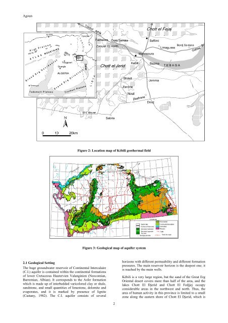
Agoun<br />
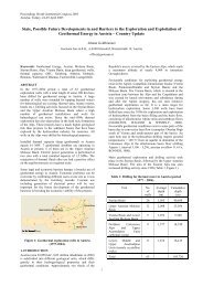
Figure 2: Loc<strong>at</strong>ion map of <strong>Kébili</strong> geo<strong>the</strong>rmal field<br />
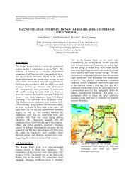
Figure 3: Geological map of aquifer system<br />
2.1 Geological Setting<br />
<strong>The</strong> huge groundw<strong>at</strong>er reservoir of <strong>Continental</strong> <strong>Intercalaire</strong><br />
(C.I.) aquifer is contained within <strong>the</strong> continental form<strong>at</strong>ions<br />
of lower Cretaceous Hautervien Valanginien (Neocomian,<br />
Barremian, Albian). It corresponds to <strong>the</strong> Asfer form<strong>at</strong>ion<br />
which is made up of interbedded varicolored clay or shale,<br />
sandstone, and small quantities of limestone, dolomite and<br />
evapor<strong>at</strong>es, and it is marked by presence of lignite<br />
(Castany, 1982). <strong>The</strong> C.I. aquifer consists of several<br />
horizons with different permeability and different form<strong>at</strong>ion<br />
pressures. <strong>The</strong> main reservoir horizon is <strong>the</strong> deepest one; it<br />
is reached by <strong>the</strong> main wells.<br />
<strong>Kébili</strong> is a very large region, but <strong>the</strong> sand of <strong>the</strong> Gre<strong>at</strong> Erg<br />
Oriental desert covers more than half of <strong>the</strong> area, and <strong>the</strong><br />
lakes Chott El Djerid and Chott El Fedjjej occupy<br />
considerable areas in <strong>the</strong> northwest and north. Thus, <strong>the</strong><br />
area of human activity in this province is limited to a small<br />
zone along <strong>the</strong> eastern shore of Chott El Djerid, which is<br />
2