The Continental Intercalaire Aquifer at the Kébili Geothermal Field ...
The Continental Intercalaire Aquifer at the Kébili Geothermal Field ...
The Continental Intercalaire Aquifer at the Kébili Geothermal Field ...

Create successful ePaper yourself
Turn your PDF publications into a flip-book with our unique Google optimized e-Paper software.
Agoun<br />
slightly hilly country forming a kind of peninsula or island<br />
in <strong>the</strong> chott.<br />
2.2 Hydrogeology<br />
Where <strong>the</strong> <strong>Kébili</strong> geo<strong>the</strong>rmal field is loc<strong>at</strong>ed, <strong>the</strong> artesian<br />
flow r<strong>at</strong>e is usually higher than in <strong>the</strong> o<strong>the</strong>r provinces. <strong>The</strong><br />
geo<strong>the</strong>rmal gradient is approxim<strong>at</strong>ely from 29 to 35°C/km<br />
and increases from south to north. <strong>The</strong>re are three main<br />
aquifers in this region, <strong>the</strong> <strong>Continental</strong> <strong>Intercalaire</strong> and<br />
secondary aquifers within <strong>the</strong> Jurassic and <strong>the</strong> Permian. <strong>The</strong><br />
<strong>Continental</strong> <strong>Intercalaire</strong> aquifer covers <strong>the</strong> regions of<br />
<strong>Kébili</strong>, Tozeur, Gabes and <strong>the</strong> extreme south and extends to<br />
Algeria and Libya. It is characterized by temper<strong>at</strong>ures<br />
ranging from 35°C to 75°C, pressures of 14 - 22 bars and<br />
salinity of 2.2 - 4.2 g/l. <strong>The</strong> geo<strong>the</strong>rmal resource potential<br />
in <strong>the</strong> <strong>Kébili</strong> geo<strong>the</strong>rmal field is estim<strong>at</strong>ed to be 1,000 l/s<br />
(ERESS project, 1972).<br />
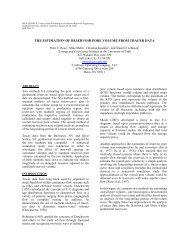
<strong>The</strong> principal areas of current or former recharge are in <strong>the</strong><br />
South Atlas Mountains of Algeria and Tunisia, <strong>the</strong> Tinrhet<br />
Pl<strong>at</strong>eau of Algeria and <strong>the</strong> Dahar Mountains of Tunisia. <strong>The</strong><br />
main discharge area is in Tunisia, in <strong>the</strong> Chotts and <strong>the</strong> Golf<br />
of Gabes. <strong>The</strong> C.I. aquifer is one of <strong>the</strong> largest confined<br />
aquifers in <strong>the</strong> world, comparable in scale to <strong>the</strong> Gre<strong>at</strong><br />
Artesian Basin of Australia and covers some 600,000 km 2 .<br />
3. MAIN UTILIZATION OF CONTINENTAL<br />
INTERCALAIRE GEOTHERMAL WATER<br />
In <strong>the</strong> <strong>Kébili</strong> region and <strong>the</strong> areas fur<strong>the</strong>r to <strong>the</strong> south <strong>the</strong>re<br />
are 24 wells reaching <strong>the</strong> different layers of <strong>the</strong> C.I. aquifer.<br />
<strong>The</strong>y are used to supply <strong>the</strong> oases with w<strong>at</strong>er for irrig<strong>at</strong>ion<br />
after cooling in cooling towers. <strong>The</strong> geo<strong>the</strong>rmal w<strong>at</strong>er is<br />
also used for <strong>the</strong> he<strong>at</strong>ing and irrig<strong>at</strong>ion of greenhouses.<br />
Fur<strong>the</strong>rmore, in <strong>the</strong> Douz region geo<strong>the</strong>rmal w<strong>at</strong>er is used<br />
for <strong>the</strong> he<strong>at</strong>ing of two swimming pools and several public<br />
b<strong>at</strong>hhouses. In both cases <strong>the</strong> return w<strong>at</strong>er is used for<br />
irrig<strong>at</strong>ing <strong>the</strong> surrounding oases (Ben Mohamed, 1997).<br />
15 - 40 m below <strong>the</strong> ground in <strong>the</strong> extreme south of Tunisia.<br />
<strong>The</strong> evalu<strong>at</strong>ion and management of w<strong>at</strong>er resources of <strong>the</strong><br />
aquifers in Sou<strong>the</strong>rn Tunisia was studied in a separ<strong>at</strong>e<br />
project in order to obtain an overview of <strong>the</strong> surface and<br />
ground w<strong>at</strong>er resources in <strong>the</strong> south, and forecasts of <strong>the</strong><br />
groundw<strong>at</strong>er conditions in <strong>the</strong> future. <strong>The</strong> volume of<br />
groundw<strong>at</strong>er resource in <strong>the</strong> south is about 46% of all<br />
groundw<strong>at</strong>er resources in Tunisia. <strong>The</strong> project “Recharge<br />
characteristics and groundw<strong>at</strong>er quality of <strong>the</strong> grand Erg<br />
Oriental Basin” was started in 1994 in cooper<strong>at</strong>ion with <strong>the</strong><br />
United Kingdom (British Geologic Survey), Algeria<br />
(C.D.T.N), and Tunisia (D.G.R.E. and E.N.I.S.). <strong>The</strong> main<br />
goal of this project is to define <strong>the</strong> limits of sustainable<br />
groundw<strong>at</strong>er development in <strong>the</strong> aquifer system of <strong>the</strong><br />
Grand Erg Oriental underlying eastern Algeria and sou<strong>the</strong>rn<br />
Tunisia. This project is for all <strong>the</strong> aquifers in this area and<br />
aims <strong>at</strong> determining <strong>the</strong> modern r<strong>at</strong>es of recharge and <strong>the</strong><br />
interface between recent recharge and paleow<strong>at</strong>ers. Finally,<br />
<strong>the</strong> study (S.A.S.S: Systeme aquifer du Sahara<br />
Septentrional) carried out by <strong>the</strong> "Sahara and Sahel<br />
Observ<strong>at</strong>ory" commenced in 1999. <strong>The</strong> main objectives of<br />
<strong>the</strong> project are to evalu<strong>at</strong>e and expand previous studies of<br />
<strong>the</strong> deep aquifers (C.I. C.T. Djeffara) in eastern Algeria,<br />
sou<strong>the</strong>rn Tunisia and, for <strong>the</strong> first time, Libya.<br />
STEAM HEATED WATERS<br />
100 75<br />
50<br />
25<br />
0<br />
Cl<br />
Cl<br />
100 75<br />
SO 4<br />
HCO 3<br />
.<br />
MATURE<br />
WATERS<br />
50<br />
PERIPHERAL WATERS<br />
25<br />
0<br />
4<br />
5<br />
6<br />
7<br />
8<br />
9<br />
10<br />
11<br />
12<br />
Mbs<br />
14<br />
KG3<br />
SO 4<br />
HCO 3<br />
0 25 50 75 100<br />
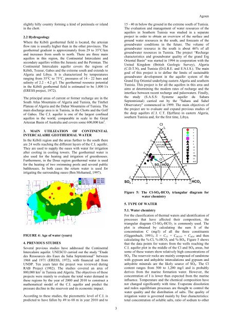
Figure 5: <strong>The</strong> Cl-SO 4 -HCO 3 triangular diagram for<br />
w<strong>at</strong>er chemistry<br />
FIGURE 4: Age of w<strong>at</strong>er (years)<br />
4. PREVIOUS STUDIES<br />
Several previous studies have addressed <strong>the</strong> <strong>Continental</strong><br />
<strong>Intercalaire</strong> aquifer. UNESCO carried out <strong>the</strong> study “Etude<br />
des Ressources des Eaux du Saha Septentrional” between<br />
1968 and 1971 (ERESS, 1972), with financial aid from<br />
UNDP. Ten years l<strong>at</strong>er <strong>the</strong> project was reviewed during<br />
RAB Project (1982). <strong>The</strong> studies covered an area of<br />
800,000 km 2 in Tunisia and Algeria. <strong>The</strong> objectives of <strong>the</strong>se<br />
projects were mainly to evalu<strong>at</strong>e <strong>the</strong> total w<strong>at</strong>er demand in<br />
<strong>the</strong>se regions by <strong>the</strong> year of 2000 and 2010 to construct a<br />
m<strong>at</strong>hem<strong>at</strong>ical model of <strong>the</strong> C.I. aquifer and predict <strong>the</strong><br />
pressure decline in <strong>the</strong> reservoir and its economic impact.<br />
According to <strong>the</strong>se studies, <strong>the</strong> piezometric level of C.I. is<br />
predicted to have fallen by 49 to 68 m in year 2010 and to<br />
5. TYPE OF WATER<br />
5.1. W<strong>at</strong>er chemistry<br />
For <strong>the</strong> classific<strong>at</strong>ion of <strong>the</strong>rmal w<strong>at</strong>ers and identific<strong>at</strong>ion of<br />
processes th<strong>at</strong> have affected <strong>the</strong>ir composition, <strong>the</strong><br />
triangular diagram Cl-SO 4 -HCO 3 is commonly used. <strong>The</strong><br />
plot is obtained by calcul<strong>at</strong>ing <strong>the</strong> sum S of <strong>the</strong><br />
concentr<strong>at</strong>ion C (mg/l) of all <strong>the</strong> three constituents<br />
(Giggenbach, 1991), S = C Cl + C HCO3 + C SO4 and <strong>the</strong>n<br />
calcul<strong>at</strong>ing <strong>the</strong> %-Cl, %-HCO 3 and %-SO 4 . Figure 5 shows<br />
th<strong>at</strong> <strong>the</strong> d<strong>at</strong>a points for w<strong>at</strong>ers from <strong>the</strong> wells reaching <strong>the</strong><br />
C.I. aquifer plot in <strong>the</strong> middle of <strong>the</strong> Cl and SO 4 areas, but<br />
some of <strong>the</strong>se w<strong>at</strong>ers show rel<strong>at</strong>ively high concentr<strong>at</strong>ions of<br />
SO 4 . <strong>The</strong> reservoir rocks are mainly composed of sandstone<br />
with gypsum and anhydrite intercal<strong>at</strong>ions and gypsum and<br />
anhydrite minerals are <strong>the</strong> likely source of SO 4 . <strong>The</strong> Cl<br />
content ranges from 500 to 1,200 mg/l and is probably<br />
derives from <strong>the</strong> marine form<strong>at</strong>ion w<strong>at</strong>er. However, <strong>the</strong><br />
concentr<strong>at</strong>ion of I is lower than expected from <strong>the</strong> marine<br />
influence. Temper<strong>at</strong>ure and <strong>the</strong> chemical composition have<br />
not changed significantly with time. Evapor<strong>at</strong>e dissolution<br />
and redox equilibrium processes are thought to control <strong>the</strong><br />
w<strong>at</strong>er quality and <strong>the</strong> distribution of salts. <strong>The</strong> quality of<br />
irrig<strong>at</strong>ion w<strong>at</strong>er is governed mainly by four characteristics:<br />
total concentr<strong>at</strong>ion of soluble salts, r<strong>at</strong>io of sodium to o<strong>the</strong>r<br />
3