Pedestrian Count Study - Downtown Raleigh Alliance
Pedestrian Count Study - Downtown Raleigh Alliance
Pedestrian Count Study - Downtown Raleigh Alliance

You also want an ePaper? Increase the reach of your titles
YUMPU automatically turns print PDFs into web optimized ePapers that Google loves.
Saunders St.<br />
N. Dawson St.<br />
N. McDowell St.<br />
N. Salisbury St.<br />
FAY ETTEVILLE STREET<br />
N. Wilmington St.<br />
N. Blount St.<br />
N. Person St.<br />
sidewalk” within 50 feet of the screenline. Those counted were: people<br />
walking, people in wheel chairs, children in strollers, people on segways,<br />
and those riding bikes on the sidewalk. The purpose of employing the<br />
50 foot buffer on both sides of the screenline is to capture all pedestrian<br />
activity entering and exiting buildings, as well as loading or off-loading<br />
public transportation that may not cross the screenline but should be<br />
included in the study.<br />
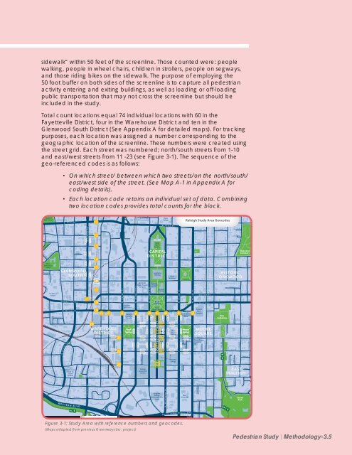
Total count locations equal 74 individual locations with 60 in the<br />
Fayetteville District, four in the Warehouse District and ten in the<br />
Glenwood South District (See Appendix A for detailed maps). For tracking<br />
purposes, each location was assigned a number corresponding to the<br />
geographic location of the screenline. These numbers were created using<br />
the street grid. Each street was numbered; north/south streets from 1-10<br />
and east/west streets from 11 -23 (see Figure 3-1). The sequence of the<br />
geo-referenced codes is as follows:<br />
• On which street/ between which two streets/on the north/south/<br />
east/west side of the street. (See Map A-1 in Appendix A for<br />
coding details).<br />
• Each location code retains an individual set of data. Combining<br />
two location codes provides total counts for the block.<br />
Broughton<br />
High School<br />
W. Park Dr.<br />
Va ley View St.<br />
Curickshank Cir.<br />
Smedes Hall Cir.<br />
E Park Dr.<br />
McCulloch St.<br />
Stokes St.<br />
Hillcrest Rd.<br />
Snow Ave.<br />
Calvin Rd.<br />
Wiley<br />
Elementary<br />
School<br />
St. Mary’s<br />
School<br />
Mountford St.<br />
Cutler St.<br />
St. Mary’s St.<br />
Parkham Ln.<br />
Gaston St.<br />
Hillsborough St.<br />
W. Morgan St.<br />
S . B o y l a n<br />
E. Peace St.<br />
W. Hargett St.<br />
.<br />
A v e<br />
Kinsey St.<br />
N. Boylan Ave.<br />
W. Johnson St.<br />
Tucker St.<br />
Anwood Pl.<br />
W. North St.<br />
W. Lane St.<br />
GLENWOOD<br />
SOUTH<br />
Project<br />
Enlightenment<br />
(Wake Co.<br />
School<br />
System)<br />
W. Jones St.<br />
Willard Pl.<br />
Dupont Cir.<br />
Rosengarten St.<br />
30112134<br />
30113144<br />
30114154<br />
30115164<br />
Glenwood Ave<br />
1<br />
30112133<br />
30113143<br />
30114153<br />
30115163<br />
McClure<br />
W. Cabarrus St.<br />
11<br />
12<br />
13<br />
14<br />
15<br />
16<br />
W. Lenoir St.<br />
31601021<br />
31601022<br />
17<br />
18<br />
19<br />
S. West St. N. West St.<br />
2<br />
N. Harrington St.<br />
3<br />
S. Harrington St .<br />
Commerce Pl.<br />
4<br />
20<br />
WAREHOUSE<br />
DISTRICT<br />
22103041<br />
21<br />
22103042<br />
22203041<br />
22203042<br />
22<br />
23<br />
Campbell<br />
Law School<br />
<strong>Raleigh</strong><br />
Municipal<br />
Complex<br />
Nash<br />
Square<br />
5<br />
10519204<br />
10520214<br />
10521224<br />
Seaboard Ave.<br />
NCDENR<br />
Green Square<br />
Complex<br />
Vaughn Ct.<br />
Harp St.<br />
W. Peace St.<br />
Hillsborough St. New Bern Ave.<br />
10519203<br />
10520213<br />
10521223<br />
12005061<br />
12005062<br />
12105061<br />
12105062<br />
12205061<br />
12205062<br />
Gale St.<br />
<strong>Raleigh</strong><br />
Convention<br />
Center<br />
Wake<br />
<strong>Count</strong>y<br />
Courthouse<br />
State<br />
Gov’t<br />
Complex<br />
Legislative<br />
Building<br />
Museum<br />
of History<br />
Exchange Plz<br />
Market Plz<br />
RBC<br />
Building<br />
Peace<br />
College<br />
CAPITAL<br />
DISTRICT<br />
6<br />
10619204<br />
10620214<br />
10621224<br />
Museum<br />
of Natural<br />
Sciences<br />
10619203<br />
State<br />
Capitol<br />
State<br />
Courthouses<br />
7<br />
10719204<br />
12006071<br />
12006072<br />
10620213<br />
10621223<br />
10720214<br />
12106071<br />
12106072<br />
10721224<br />
12206071<br />
12206072<br />
City<br />
Plaza<br />
10722234<br />
10719203<br />
8<br />
10819204<br />
12007081<br />
12007082<br />
10720213<br />
10820214<br />
12107081<br />
12107082<br />
10721223<br />
10821224<br />
12207081<br />
12207082<br />
10722233<br />
State<br />
Archives<br />
E. Morgan St.<br />
10819203<br />
10820213<br />
10821223<br />
12008091<br />
12008092<br />
Moore<br />
Square<br />
Station<br />
12108091<br />
12108092<br />
12208091<br />
12208092<br />
Progress<br />
Energy<br />
Stronachs Aly.<br />
9<br />
10919204<br />
10920214<br />
10921224<br />
Wolf St.<br />
Regan Ln.<br />
E. North St.<br />
E. Jones St.<br />
Minerva St.<br />
Marbles Kids<br />
Museum and<br />
IMAX<br />
10919203<br />
10920213<br />
10921223<br />
Moore<br />
Square<br />
Blake St.<br />
<strong>Raleigh</strong> <strong>Study</strong> Area Geocodes<br />
12109101<br />
12109102<br />
12209101<br />
12209102<br />
City<br />
Market<br />
10<br />
Pell St.<br />
Polk St.<br />
Oakwood Ave.<br />
E. Lane St.<br />
Edenton St.<br />
New Bern Ave.<br />
Federal<br />
Gov’t<br />
Complex<br />
E. Hargett St.<br />
MOORE<br />
SQUARE<br />
E. Martin St.<br />
Moore Square<br />
Museum<br />
MS<br />
Loves Ln<br />
E. Canarrus St.<br />
E. Lenoir St.<br />
S. Bloodsworth St.<br />
N. East St.<br />
Euclid St.<br />
Chavis Way<br />
E<br />
Chavis Way<br />
Elm St.<br />
Woodsborough Pl.<br />
Watson St.<br />
Leonidas Ct.<br />
Latham Way<br />
Ray St.<br />
Watauga St.<br />
Linden Ave.<br />
HISTORIC<br />
OAKWOOD<br />
City<br />
Cemetery<br />
Mosely Ln<br />
Monie Ln.<br />
E. Davie St.<br />
Dakar St.<br />
S. Swain St.<br />
Oakwood<br />
Cemetery<br />
Cooke St.<br />
Candor Ln.<br />
EAST<br />
RALEIGH<br />
Hay Ln.<br />
Haywood St.<br />
W. South St.<br />
E. South St.<br />
Wynne St<br />
Florence St.<br />
Dorthea Dr.<br />
Kindly St.<br />
Progress<br />
Energy<br />
Performing Arts<br />
Center<br />
Shaw<br />
University<br />
Elington St<br />
Worth St.<br />
Homes St.<br />
Chavis<br />
Park<br />
Chatham Ter<br />
W E S T E R N B L V D<br />
E<br />
M a r t i n L u t h e r K i n g J r . B l v d .<br />
0 0.25 0.5 1 Mile<br />
Elington St<br />
Cape Ave.<br />
E<br />
Figure 3-1: <strong>Study</strong> Area with reference numbers and geocodes.<br />
(Maps adapted from previous Greenways Inc. project)<br />
<strong>Pedestrian</strong> <strong>Study</strong> | Methodology-3.5