Hain, M., Strecker, M.R., Bookhagen, B., Alonso, R.N., Pingel, H. and ...
Hain, M., Strecker, M.R., Bookhagen, B., Alonso, R.N., Pingel, H. and ...
Hain, M., Strecker, M.R., Bookhagen, B., Alonso, R.N., Pingel, H. and ...

You also want an ePaper? Increase the reach of your titles
YUMPU automatically turns print PDFs into web optimized ePapers that Google loves.
TC2006<br />
HAIN ET AL.: SALTA FORELAND FRAGMENTATION<br />
TC2006<br />
from N to S, displaying covariance with the location of the<br />
El Toro lineament (Figures 12b <strong>and</strong> 2). This characteristic<br />
compositional signal must originate from the ranges (herein<br />
central EC) presently separating the Calchaquí Valley in the<br />
western EC from the Lerma Valley in the eastern sector<br />
of the EC. In contrast to the Piquete Formation, the coeval<br />
San Felipe Formation in the Calchaquí Valley retains<br />
Guanaco‐like conglomerate compositions characterized by<br />
plutonic <strong>and</strong> high‐grade metamorphic clasts [Cout<strong>and</strong> et al.,<br />
2006]. The uplift of the central EC ranges must therefore<br />
have been able to intercept sediment transport from the Puna<br />
margin, causing the divergence between the Piquete <strong>and</strong><br />
San Felipe conglomerate compositions. This scenario is also<br />
compatible with changing transport directions in the San<br />
Felipe Formation of the Calchaquí Valley; showing eastward<br />
<strong>and</strong> southward directed paleoflow directions in conglomerates<br />
(A. Richter, unpublished data, 2002) (Figure 2b).<br />
[36] Diverging from the above pattern, the Piquete Formation<br />
is anomalous at two clast count stations (32 <strong>and</strong> 34) in<br />
the SBS in that it resembles the composition of the Guanaco<br />
Formation (Figure 12a <strong>and</strong> Table 3), suggesting either limited<br />
Puna margin sourced sediment bypassing the EC into<br />
the SBS or, alternatively, reworking of the Guanaco Formation<br />
as observed in the central [e.g., Gonzalez Villa, 2002] <strong>and</strong><br />
eastern parts of the EC.<br />
[37] Notably, in the southernmost Lerma Valley (eastern<br />
EC) clast imbrications indicate north directed transport<br />
(Station g in Figure 2b). However, the characteristic hornblende‐bearing<br />
volcanic lithology exposed today in the<br />
Ovejeria Range to the south, is absent (clast count station 39).<br />
[38] Overall, the change of conglomerate composition from<br />
the Guanaco Formation to the Piquete Formation suggests<br />
that between ∼5 <strong>and</strong> 2 Ma coarse sediments shed from the<br />
Puna margin were trapped in the intermontane Calchaquí<br />
Valley (i.e., the San Felipe Formation, western EC) rather<br />
than being exported from the orogen interior. It appears that<br />
the uplift of the central EC ranges at ∼5 Ma (1) produced<br />
the sediment that constitutes the Piquete Formation <strong>and</strong> (2)<br />
intercepted the Puna margin derived gravel.<br />
4.2.3. La Troja Formation<br />
[39] Conglomerate compositions for the Piquete Formation<br />
<strong>and</strong> the La Troja Formation are indistinguishable in the<br />
eastern EC except for the decrease in basement clasts<br />
<strong>and</strong> the increased contribution of clasts derived from the<br />
Paleozoic <strong>and</strong> Cretaceous sedimentary cover units to the<br />
La Troja Formation conglomerates (relative to Piquete Formation).<br />
This difference indicates a shift toward less unroofed<br />
sections in the source regions <strong>and</strong>/or uplift of new<br />
sources (Figure 12b) [cf. Monaldi et al., 1996]. In contrast to<br />
the Piquete Formation, Pirgua Subgroup s<strong>and</strong>stones, which<br />
disintegrate over very short transport distances in modern<br />
rivers, frequently contribute to the La Troja Formation<br />
conglomerates in areas proximal to the present‐day ranges<br />
of the central EC, south of the El Toro lineament.<br />
[40] North of the El Toro lineament, the lithologic contrast<br />
between the central EC ranges <strong>and</strong> the Mojotoro Range is<br />
minimal <strong>and</strong> conglomerate compositions (but not facies; see<br />
section 4.3.3) are similar of the Piquete <strong>and</strong> La Troja formations<br />
in both eastern EC <strong>and</strong> SBS. In the SBS, however,<br />
Ordovician fossil‐bearing s<strong>and</strong>stones of the Mojotoro Formation,<br />
which are prone to abrasion in modern rivers, contribute<br />
to the La Troja Formation, but not to the Piquete<br />
Formation, suggesting a marked decrease in transport distance.<br />
[41] At the southern tip of the Mojotoro Range <strong>and</strong> only<br />
few kilometers downstream from the Castillejo Range, the<br />
only exposure of black carbonates in the region (Las Tienditas<br />
Formation) provides a very direct lithologic constraint<br />
(Figure 2a) on the source area for the La Troja Formation in<br />
the SBS. While the Guanaco <strong>and</strong> Piquete formations as<br />
well as the base of the exposed section of the La Troja Formation<br />
infilling of the local syncline (see section 4.1.3 <strong>and</strong><br />
Figure 11) are devoid of Las Tienditas clasts (Table 3)<br />
[Gonzalez Villa, 2002], boulders of the Las Tienditas Formation<br />
appear toward the top of the La Troja section,<br />
attesting to Quaternary uplift of the Castillejo Range.<br />
[42] In summary, it appears that most of the sediment<br />
contributing to the La Troja Formation in the SBS is derived<br />
from the ranges at the EC/SBS boundary (i.e., Mojotoro,<br />
Castillejo <strong>and</strong> Metán ranges). Furthermore, there is evidence<br />
that large sediment volumes shed from the central EC ranges<br />
were trapped by intrabasin structures in the eastern EC<br />
(Lerma Valley). The characteristic lithologies exposed along<br />
the Puna margin are absent from La Troja Formation conglomerates<br />
in both eastern EC <strong>and</strong> SBS, which indicates that<br />
these sediments were efficiently trapped in the western EC<br />
(Calchaquí Valley).<br />
4.3. Sediment Dynamics<br />
4.3.1. Guanaco Formation<br />
[43] The geometries of well‐defined conglomeratic channels<br />
embedded in well‐sorted s<strong>and</strong>stones within the EC <strong>and</strong><br />
an alternating mudstone‐s<strong>and</strong>stone‐conglomerate sequence<br />
in the SBS attest to an east‐west gradient in the depositional<br />
environment. The common provenance signature in Guanaco<br />
Formation conglomerates throughout the EC <strong>and</strong> the<br />
SBS (see section 4.2.1 for one exception) with an unambiguous<br />
source area near the eastern Puna border suggests a<br />
single contiguous depositional system. Strata farther north in<br />
the Sub<strong>and</strong>ean Belt, characterized by facies relationships<br />
similar to those that we document here for the SBS [see also<br />
Gonzalez Villa, 2002], have been related to a fluvial megafan<br />
depositional environment [e.g., Horton <strong>and</strong> DeCelles, 2001;<br />
Leier et al., 2005; Uba et al., 2005, 2007, 2009]. The Guanaco<br />
Formation may thus also be interpreted as a fluvial megafan;<br />
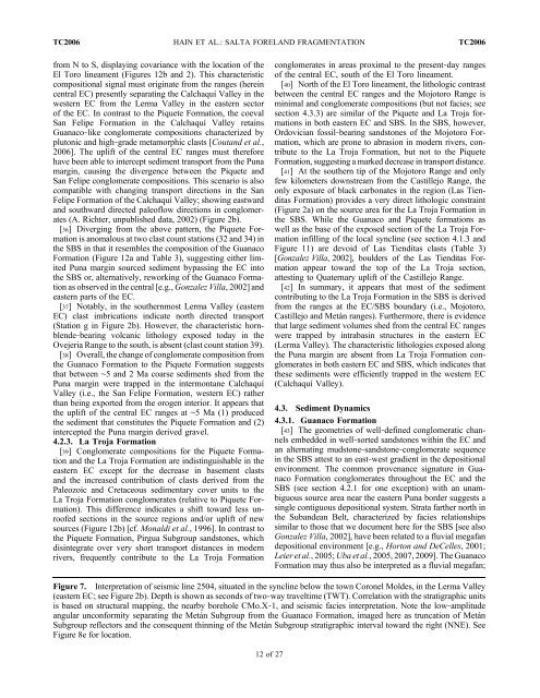
Figure 7. Interpretation of seismic line 2504, situated in the syncline below the town Coronel Moldes, in the Lerma Valley<br />
(eastern EC; see Figure 2b). Depth is shown as seconds of two‐way traveltime (TWT). Correlation with the stratigraphic units<br />
is based on structural mapping, the nearby borehole CMo.X‐1, <strong>and</strong> seismic facies interpretation. Note the low‐amplitude<br />
angular unconformity separating the Metán Subgroup from the Guanaco Formation, imaged here as truncation of Metán<br />
Subgroup reflectors <strong>and</strong> the consequent thinning of the Metán Subgroup stratigraphic interval toward the right (NNE). See<br />
Figure 8e for location.<br />
12 of 27