Hain, M., Strecker, M.R., Bookhagen, B., Alonso, R.N., Pingel, H. and ...
Hain, M., Strecker, M.R., Bookhagen, B., Alonso, R.N., Pingel, H. and ...
Hain, M., Strecker, M.R., Bookhagen, B., Alonso, R.N., Pingel, H. and ...

Create successful ePaper yourself
Turn your PDF publications into a flip-book with our unique Google optimized e-Paper software.
TC2006<br />
HAIN ET AL.: SALTA FORELAND FRAGMENTATION<br />
TC2006<br />
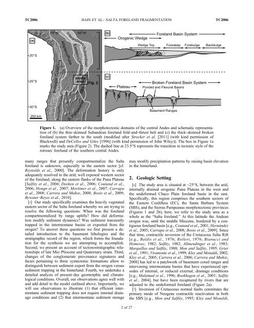
Figure 1. (a) Overview of the morphotectonic domains of the central Andes <strong>and</strong> schematic representation<br />
of (b) the thin‐skinned Sub<strong>and</strong>ean forel<strong>and</strong> fold‐<strong>and</strong>‐thrust belt <strong>and</strong> (c) the thick‐skinned broken<br />
forel<strong>and</strong> system farther to the south (modified after <strong>Strecker</strong> et al. [2011] (with kind permission of<br />
Blackwell) <strong>and</strong> DeCelles <strong>and</strong> Giles [1996] (with kind permission of John Wiley)). The box in Figure 1a<br />
marks the study area (Figure 2). The dashed line at 23.5°S represents the transition in tectonic style of the<br />
retroarc forel<strong>and</strong> of the southern central Andes.<br />
many ranges that presently compartmentalize the Salta<br />
forel<strong>and</strong> is unknown, especially in the eastern sector [cf.<br />
Reynolds et al., 2000]. The deformation history is only<br />
adequately resolved in the arid, well exposed western sector<br />
of the forel<strong>and</strong>, along the eastern flanks of the Puna Plateau<br />
[Salfity et al., 2004; Deeken et al., 2006; Cout<strong>and</strong> et al.,<br />
2006; Hongn et al., 2007; Mortimer et al., 2007; Carrapa<br />
et al., 2008; Carrera <strong>and</strong> Muñoz, 2008; Bosio et al., 2009;<br />
Bywater‐Reyes et al., 2010].<br />
[5] Our study specifically examines the heavily vegetated<br />
eastern sector of the Salta forel<strong>and</strong> whereby we are trying to<br />
resolve the following questions: When was the forel<strong>and</strong><br />
compartmentalized by range uplifts? How did deformation<br />
modify sediment dynamics? Was sediment transiently<br />
trapped in the intermontane basins or exported from the<br />
orogen? To answer these questions we first present a detailed<br />
introduction to the basement lithologies <strong>and</strong> the<br />
stratigraphic record of the region, which forms the foundation<br />
for the synthesis we are attempting to accomplish.<br />
Second, we present an account of tectonostratigraphic relationships<br />
of late Mio‐Pliocene <strong>and</strong> Quaternary strata. Third,<br />
changes of the conglomerate provenance signatures <strong>and</strong><br />
facies pertaining to three syntectonic formations allow to<br />
distinguish between sediment export from the orogen versus<br />
sediment trapping in the hinterl<strong>and</strong>. Fourth, we undertake a<br />
detailed analysis of present‐day geomorphic <strong>and</strong> climatological<br />
conditions. Overall, our observations agree well with<br />
<strong>and</strong> add detail to the model outlined above. Importantly, we<br />
will use observations to illustrate (1) that efficient intermontane<br />
sediment trapping does not require internal drainage<br />
conditions <strong>and</strong> (2) that intermontane sediment storage<br />
may modify precipitation patterns by raising basin elevation<br />
in the hinterl<strong>and</strong>.<br />
2. Geologic Setting<br />
[6] The study area is situated at ∼25°S, between the arid,<br />
internally drained orogenic Puna Plateau in the west <strong>and</strong><br />
the undeformed Chaco Plain forel<strong>and</strong> basin in the east.<br />
Specifically, this region comprises the southern sectors of<br />
the Eastern Cordillera (EC), the Santa Barbara System<br />
(SBS), <strong>and</strong> the Sierras Pampeanas morphotectonic provinces<br />
(Figures 1 <strong>and</strong> 2b); here, we refer to the study area as a<br />
whole as the “Salta forel<strong>and</strong>.” At this latitude the Andean<br />
orogen was, until the middle Miocene, bordered by a contiguous<br />
forel<strong>and</strong> basin [e.g., Cout<strong>and</strong> et al., 2001; Hernández<br />
et al., 2005; Carrapa et al., 2008; Bosio et al., 2009]. Since<br />
that time, contractile inversion of the Cretaceous Salta Rift<br />
[e.g., Baldis et al., 1976; Rolleri, 1976; Bianucci <strong>and</strong><br />
Homovec, 1982; Salfity, 1982; Allmendinger et al., 1983;<br />
Marquillas <strong>and</strong> Salfity, 1988; Mon <strong>and</strong> Salfity, 1995; Grier<br />
et al., 1991; Viramonte et al., 1999; Kley <strong>and</strong> Monaldi, 2002;<br />
Kley et al., 2005; Carrera et al., 2006; Carrera <strong>and</strong> Muñoz,<br />
2008] has led to a patchwork of basement‐cored ranges <strong>and</strong><br />
intervening intermontane basins that have experienced episodes<br />
of internal, or reduced external, drainage conditions<br />
[e.g., Malamud et al., 1996; <strong>Bookhagen</strong> et al., 2001; Salfity<br />
et al., 2004], but have been recaptured by rivers that are<br />
adjusted to the undeformed forel<strong>and</strong> (Figure 2a).<br />
[7] Inversion of Cretaceous normal faults constitutes the<br />
primary mode of Neogene contractile reactivation in both<br />
the SBS [e.g., Mon <strong>and</strong> Salfity, 1995; Kley <strong>and</strong> Monaldi,<br />
2of27