Hain, M., Strecker, M.R., Bookhagen, B., Alonso, R.N., Pingel, H. and ...
Hain, M., Strecker, M.R., Bookhagen, B., Alonso, R.N., Pingel, H. and ...
Hain, M., Strecker, M.R., Bookhagen, B., Alonso, R.N., Pingel, H. and ...

Create successful ePaper yourself
Turn your PDF publications into a flip-book with our unique Google optimized e-Paper software.
TC2006<br />
HAIN ET AL.: SALTA FORELAND FRAGMENTATION<br />
TC2006<br />
originating along the Puna border <strong>and</strong> shedding sediment<br />
>100 km into the forel<strong>and</strong>.<br />
4.3.2. Piquete Formation<br />
[44] The characteristic lateral continuity of well imbricated<br />
conglomerate horizons in the eastern EC indicates<br />
deposition from unconfined flow at relatively high flow<br />
velocities, conditions that may be related to an alluvial fan<br />
environment below the intersection point [e.g., Blair <strong>and</strong><br />
McPherson, 1994]. Facies associations in the SBS are in<br />
accord with distal fan/alluvial plain depositional systems.<br />
The central EC provenance signature (see section 4.2.2) is<br />
prevalent in both eastern EC <strong>and</strong> SBS. The Piquete Formation<br />
thus appears to be the stratigraphic remnant of a<br />
formerly contiguous alluvial fan system, proximal in the<br />
eastern EC <strong>and</strong> distal in the SBS [cf. Gonzalez Villa, 2002].<br />
4.3.3. La Troja Formation<br />
[45] The Quaternary La Troja Formation has not been<br />
described in detail so far making it timely to document its<br />
facies before interpreting the depositional environment <strong>and</strong><br />
sediment dynamics.<br />
[46] In both eastern EC <strong>and</strong> SBS, the La Troja Formation<br />
comprises poorly stratified <strong>and</strong> poorly sorted s<strong>and</strong>y gravels<br />
alternating with gravelly s<strong>and</strong>s <strong>and</strong> clayey s<strong>and</strong>s (see also<br />
Figure 8a). The gravels are frequently matrix supported,<br />
but clast‐supported cobbles exist in channel‐like lenses. At<br />
some stratigraphic levels occasional boulders are embedded<br />
in gravelly s<strong>and</strong>stones. Siltstones are absent, with the exception<br />
of the upper stratigraphic levels of the Coronel<br />
Moldes syncline (i.e., west of the Coronel Moldes anticline),<br />
where massive banks of friable, chalky, muddy siltstones,<br />
containing only rare granules, are associated with infrequent,<br />
heavily cemented, longitudinal (i.e., N‐S oriented)<br />
gravel‐filled channels.<br />
[47] The facies associated with the remnant alluvial fan to<br />
the east of the Mojotoro Range (Figure 11) are in stark<br />
contrast to those described above. Proximal to this range the<br />
La Troja Formation is exposed in vertical walls of fanglomerate<br />
with no discernible bedding, many tens of meters<br />
high (e.g., clast count station 19). The remnant fan surface<br />
slopes to the east <strong>and</strong> east sloping bedding, defined by<br />
alternating banks of gravelly s<strong>and</strong>s <strong>and</strong> s<strong>and</strong>y gravels,<br />
becomes progressively better developed toward the toe<br />
of the fan. A massive fanglomerate outcrop, similar to the<br />
proximal Mojotoro fan, can be found in the eastern EC near<br />
Talapampa (clast count station 21). Here, gravel clasts are<br />
dominated by the peculiar hornblende‐bearing volcanic<br />
lithology deriving from outcrops less than 10 km to the south.<br />
[48] Based on these observations, the depositional environment<br />
of the La Troja Formation is best described as<br />
proximal alluvial fan systems that developed where streams<br />
exit the different range fronts. The transition from proximal<br />
fanglomerates to more distal conglomerate/s<strong>and</strong>stone strata<br />
reflects fluvial processing on the fan surface. These fan<br />
systems are also affected by the deformation of the basin<br />
interior of both the eastern EC <strong>and</strong> the SBS; large volumes<br />
of the La Troja Formation sediments are accommodated by<br />
synclines that formed during deposition. The poor sorting<br />
<strong>and</strong> poorly developed bedding of the La Troja sediments<br />
filling these synclines may be attributed to the dominance<br />
of gravity flow, rather than fluvial, sediment transport<br />
mechanisms. It appears that La Troja sediments have not<br />
been transported far, but instead were stored adjacent to the<br />
various sediment source regions. The facies <strong>and</strong> provenance<br />
signatures of these deposits are thus characterized by pronounced<br />
spatial heterogeneity.<br />
4.4. Moisture Supply to the Eastern Flanks<br />
of the Andean Orogen<br />
[49] Previous studies have highlighted the tectonic fragmentation<br />
<strong>and</strong> progressive aridification of the Andean hinterl<strong>and</strong><br />
in the immediate vicinity of the Puna as a driver of<br />
sedimentary processes <strong>and</strong> sustained severed drainage conditions<br />
in intermontane basins [e.g., Starck <strong>and</strong> Anzótegui,<br />
2001; Kleinert <strong>and</strong> <strong>Strecker</strong>, 2001; Sobel <strong>and</strong> <strong>Strecker</strong>,<br />
2003; Sobel et al., 2003; <strong>Alonso</strong> et al., 2006; Cout<strong>and</strong><br />
et al., 2006; <strong>Strecker</strong> et al., 2007a, 2007b]. A detailed<br />
account of the present‐day geomorphic conditions <strong>and</strong> related<br />
climate patterns for the broken Salta forel<strong>and</strong> are<br />
provided below, <strong>and</strong> two major controls on moisture supply<br />
to the hinterl<strong>and</strong> are identified.<br />
[50] The first of these controls is related to the updraft of<br />
air caused by the atmospheric gravity wave that is generated<br />
when wind passes over a mountain range [e.g., Roe, 2005,<br />
<strong>and</strong> references therein]. This density wave causes higher<br />
precipitation on the windward slope than on the leeward<br />
slope, where the density wave causes downdraft of the air<br />
<strong>and</strong> thus a rain shadow. Such asymmetric precipitation<br />
patterns, with higher precipitation on the eastern slopes,<br />
intercepting easterly <strong>and</strong> northeasterly moisture‐bearing winds<br />
[e.g., Vera et al., 2006a, 2006b; <strong>Bookhagen</strong> <strong>and</strong> <strong>Strecker</strong>,<br />
2008], occur along all ranges in the broken Salta forel<strong>and</strong><br />
(Figures 13 <strong>and</strong> 14). However, our data suggests that ranges<br />
only reduce downwind rainfall significantly if they surpass a<br />
3 km radius relief of ∼1 km (i.e., central EC, Aconquija,<br />
Quilmes ranges <strong>and</strong> the eastern Puna border; Figure 14). A<br />
relief threshold of this type is well founded in theoretical<br />
considerations <strong>and</strong> numerical simulations by Galewsky<br />
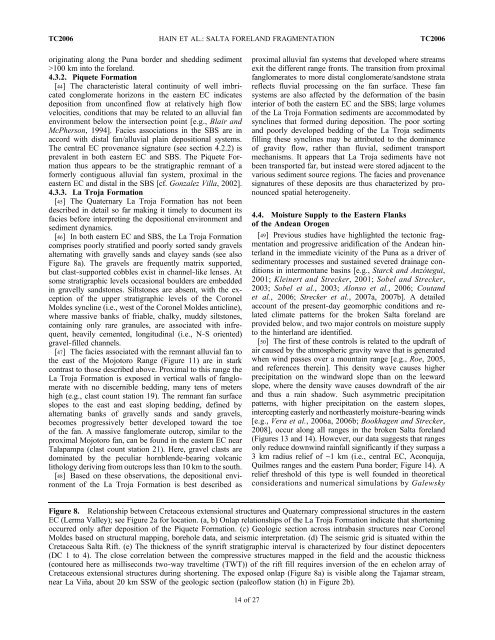
Figure 8. Relationship between Cretaceous extensional structures <strong>and</strong> Quaternary compressional structures in the eastern<br />
EC (Lerma Valley); see Figure 2a for location. (a, b) Onlap relationships of the La Troja Formation indicate that shortening<br />
occurred only after deposition of the Piquete Formation. (c) Geologic section across intrabasin structures near Coronel<br />
Moldes based on structural mapping, borehole data, <strong>and</strong> seismic interpretation. (d) The seismic grid is situated within the<br />
Cretaceous Salta Rift. (e) The thickness of the synrift stratigraphic interval is characterized by four distinct depocenters<br />
(DC 1 to 4). The close correlation between the compressive structures mapped in the field <strong>and</strong> the acoustic thickness<br />
(contoured here as milliseconds two‐way traveltime (TWT)) of the rift fill requires inversion of the en echelon array of<br />
Cretaceous extensional structures during shortening. The exposed onlap (Figure 8a) is visible along the Tajamar stream,<br />
near La Viña, about 20 km SSW of the geologic section (paleoflow station (h) in Figure 2b).<br />
14 of 27