Hain, M., Strecker, M.R., Bookhagen, B., Alonso, R.N., Pingel, H. and ...
Hain, M., Strecker, M.R., Bookhagen, B., Alonso, R.N., Pingel, H. and ...
Hain, M., Strecker, M.R., Bookhagen, B., Alonso, R.N., Pingel, H. and ...

You also want an ePaper? Increase the reach of your titles
YUMPU automatically turns print PDFs into web optimized ePapers that Google loves.
TC2006<br />
HAIN ET AL.: SALTA FORELAND FRAGMENTATION<br />
TC2006<br />
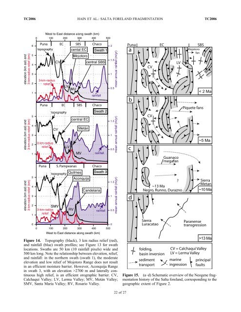
Figure 14. Topography (black), 3 km radius relief (red),<br />
<strong>and</strong> rainfall (blue) swath profiles; see Figure 13 for swath<br />
locations. Swaths are 50 km (10 rainfall pixels) wide <strong>and</strong><br />
500 km long. Note the relationship between elevation, relief,<br />
<strong>and</strong> rainfall: in the northern swath (swath 1), the moderate<br />
elevation <strong>and</strong> low relief of Mojotoro Range does not result<br />
in an efficient moisture barrier. However, Aconquija Range<br />
in swath 3, with an elevation >2700 m <strong>and</strong> laterally continuous<br />
high relief, is an efficient orographic barrier. CV,<br />
Calchaquí Valley; LV, Lerma Valley; MV, Metán Valley;<br />
SMV, Santa Maria Valley; RV, Rosario Valley.<br />
Figure 15. (a–d) Schematic overview of the Neogene fragmentation<br />
history of the Salta forel<strong>and</strong>, corresponding to the<br />
geographic extent of Figure 2.<br />
22 of 27