Field Trip to Southeastern Wiltshire, April 2004
Field Trip to Southeastern Wiltshire, April 2004
Field Trip to Southeastern Wiltshire, April 2004

Create successful ePaper yourself
Turn your PDF publications into a flip-book with our unique Google optimized e-Paper software.
<strong>Field</strong> <strong>Trip</strong> <strong>to</strong> <strong>Southeastern</strong> <strong>Wiltshire</strong>, <strong>April</strong> <strong>2004</strong><br />
Elizabeth Devon<br />
The trip was led by Isobel Geddes, author of Hidden<br />
Depths, <strong>Wiltshire</strong>’s Geology and Landscapes. We all met<br />
on Pepperbox Hill (SU 212248) on the crest of Dean Hill,<br />
an anticline separating the Hampshire Basin syncline in the<br />
south from the smaller Alderbury syncline in the north.<br />
The rocks in this area were gently folded during the Alpine<br />
orogeny causing Chalk <strong>to</strong> be exposed on the anticlines<br />
while the younger Tertiary deposits remain the synclines.<br />
Glauconite and quartz occur in Chilmark S<strong>to</strong>ne. Much of<br />
Hale Park Church, however, is made of orange-coloured<br />
sands<strong>to</strong>ne and pebbly sands<strong>to</strong>ne of either Tertiary or<br />
Lower Cretaceous age. Some blocks really do look like the<br />
Lower Greensand.<br />
Pepperbox Hill is made of Upper Chalk. The land falls<br />
steeply away <strong>to</strong> the north, down <strong>to</strong>wards the Tertiary rocks.<br />
Beyond, <strong>to</strong> the north, the underlying Chalk reappears in the<br />
hills. It is quite easy <strong>to</strong> pick out the Tertiary deposits <strong>to</strong> the<br />
south as the vegetation changes <strong>to</strong> woods which eventually<br />
lead <strong>to</strong> the New Forest. The Tertiary sands encourage acidloving<br />
plants while only those which like alkaline soils can<br />
grow well on the Chalk.<br />
After admiring the views and mastering the structural<br />
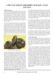
geology, we set off <strong>to</strong> the south <strong>to</strong> Pound Bot<strong>to</strong>m landfill<br />
site (SU 231179) where the Tertiary Bracklesham Beds are<br />
exposed. These are the youngest Tertiary rocks exposed in<br />
<strong>Wiltshire</strong> and are the lateral equivalent of the coloured<br />
sands of the central part of the cliffs of Alum Bay in the<br />
Isle of Wight. The colours are really spectacular,<br />
unfortunately not shown by pho<strong>to</strong>graph 1. Clays here<br />
contain glauconite which proves a marine origin. Also<br />
fossil sea snake bones have been discovered.<br />
Pho<strong>to</strong>graph 1: Bracklesham Beds, Pound Bot<strong>to</strong>m<br />
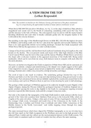
Next we visited Hale Park Church (SU 178186) just<br />
outside the county of <strong>Wiltshire</strong>. This is on the east side of<br />
the Avon valley and is on London Clay. We were<br />
interested in the building s<strong>to</strong>nes of the Church. First, we<br />
managed <strong>to</strong> identify Chilmark S<strong>to</strong>ne which occurs in the<br />
Vale of Wardour and was used for Salisbury Cathedral. It<br />
is the same age as Portland S<strong>to</strong>ne, (Upper Jurassic) but<br />
looks more like the Middle Jurassic Bath S<strong>to</strong>ne. The best<br />
way <strong>to</strong> tell the difference is by using a hand lens.<br />
Pho<strong>to</strong>graph 2: A ppp (perfect picnic place)<br />
After lunch by the Salisbury Avon (see pho<strong>to</strong>graph 2) at a<br />
site just below Hale Park Church, we continued <strong>to</strong><br />
Breamore Church (pho<strong>to</strong>graph 3) on the west side of the<br />
Avon valley. It dates from c.980 AD and is built on<br />
terrace gravels on Chalk. It is made almost entirely of flint<br />
and is a valuable and practically complete example of a<br />
Saxon building. It is exceptionally long (almost 30m) and<br />
consists of a chancel and aisle-less nave. The flints of the<br />
walls are whole and the corners<strong>to</strong>nes are made of a green<br />
sands<strong>to</strong>ne and irons<strong>to</strong>ne. These, we thought, are probably<br />
the Lower Greensand but there are Tertiary sands<strong>to</strong>nes <strong>to</strong>o.<br />
There was also evidence of Chilmark S<strong>to</strong>ne. Bath S<strong>to</strong>ne<br />
was used for the massive imposts of the arch over the south<br />
door inside the porch. Also in the porch, and also carved in<br />
Bath S<strong>to</strong>ne, is the Saxon Rood and, although badly<br />
mutilated, it is still possible <strong>to</strong> see what a striking sculpture<br />
the original must have been. In preconquest times, the<br />
whole Church, both inside and out, would have been<br />
covered in plaster. the only portions left uncovered were<br />
the corners<strong>to</strong>nes which are cut <strong>to</strong> receive it.<br />
Our next destination was Romsey Abbey, built on gravels<br />
and alluvium of the Test Valley on Tertiary London Clay.<br />
The Abbey was built between 1120 and 1240 and bought<br />
for the <strong>to</strong>wnspeople from Henry VIII for £100. Romsey<br />
Abbey is built of Chilmark S<strong>to</strong>ne and a variety of<br />
sands<strong>to</strong>nes. The famous Saxon Rood (pho<strong>to</strong>graph 4) is<br />
believed <strong>to</strong> be Bath S<strong>to</strong>ne (refer <strong>to</strong> Journal, volume 22,<br />
2003, bot<strong>to</strong>m of page 19). The decorated arch nearby is<br />
also believed <strong>to</strong> be Bath S<strong>to</strong>ne (pho<strong>to</strong>graph 5).<br />
46<br />
Journal of the Bath Geological Society, No. 23, <strong>2004</strong>
There was also an amazing variety of shapes in the flint<br />
nodules here. The view from the <strong>to</strong>p <strong>to</strong>wards Salisbury was<br />
spectacular, pho<strong>to</strong>graph 6.<br />
Pho<strong>to</strong>graph 3: Breamore Church<br />
Pho<strong>to</strong>graph 6: View <strong>to</strong>wards Salisbury from<br />
West Harnham Chalk Pit<br />
This was one of many very successful trips in<strong>to</strong> <strong>Wiltshire</strong><br />
and beyond run by Isobel for our Society. She always puts<br />
<strong>to</strong>gether a very interesting, comprehensive and well<br />
organised <strong>to</strong>ur and has so far even managed <strong>to</strong> arrange<br />
excellent weather. Thank you Isobel!<br />
Pho<strong>to</strong>graph 4: Saxon Rood, Romsey Abbey - Bath S<strong>to</strong>ne<br />
Above the head of the Crucified Christ is the Manus Dei<br />
(Hand of God) projecting downwards from the clouds<br />
Pho<strong>to</strong>graph 5: Decorated Arch of Bath S<strong>to</strong>ne on the south<br />
side of Romsey Abbey, just west of the Rood<br />
After a leisurely wander around the Abbey we set off again<br />
for West Harnham Chalk Pit (SU 128287), just south west<br />
of Salisbury. This old quarry in the Upper Chalk displays<br />
clear joint structures and Isobel was proved right when she<br />
said that it was famous for its fossil echinoids (sea<br />
urchins). Several of our members found good examples.<br />
Thank you <strong>to</strong> David Workman for his contributions <strong>to</strong> this<br />
article and for the pho<strong>to</strong>graph of the Romsey Abbey Saxon<br />
Rood.<br />
NEW FROM THE<br />
BRITISH GEOLOGICAL<br />
SURVEY<br />
The revised Bris<strong>to</strong>l Sheet 264 is now available <strong>to</strong>gether<br />
with an excellent booklet of explanation. With the map<br />
there are extensive and detailed cross sections <strong>to</strong>gether<br />
with a valuable Coal Seam Correlation table. The colourillustrated<br />
booklet is in non-specialist language and is<br />
comprehensive with chapters ranging from detailed<br />
geological descriptions <strong>to</strong> mineral and water resources,<br />
ground conditions and conservation sites.<br />
Also <strong>to</strong> be recommended is ‘Britain beneath our feet’, an<br />
atlas of digital information on Britain’s land quality,<br />
underground hazards, resources and geology.<br />
Further information from:<br />
British Geological Survey, Keyworth,<br />
Nottingham, NG12 5GG Tel: 0115 936 3100<br />
http://www.bgs.ac.uk<br />
email: sales@bgs.ac.uk<br />
Journal of the Bath Geological Society, No. 23, <strong>2004</strong> 47