Schedule 22 to the Development Plan Overlay (PDF 26.4 KB)
Schedule 22 to the Development Plan Overlay (PDF 26.4 KB)
Schedule 22 to the Development Plan Overlay (PDF 26.4 KB)

Create successful ePaper yourself
Turn your PDF publications into a flip-book with our unique Google optimized e-Paper software.
WHITTLESEA PLANNING SCHEME<br />
19/01/2006<br />
VC37<br />
SCHEDULE <strong>22</strong> TO THE DEVELOPMENT PLAN OVERLAY<br />
Shown on <strong>the</strong> planning scheme map as DPO<strong>22</strong><br />
BLUE HILLS RESIDENTIAL PRECINCT DEVELOPMENT PLAN<br />
1.0 Requirement before a permit is granted<br />
19/01/2006<br />
VC37<br />
The Responsible Authority must not grant a permit <strong>to</strong> use or subdivide land, construct a<br />
building or construct or carry out works until <strong>the</strong> owner has entered in<strong>to</strong> an agreement or<br />
agreements under section 173 of <strong>the</strong> <strong>Plan</strong>ning and Environment Act 1987 <strong>to</strong> provide for:<br />
• The transfer <strong>to</strong> or vesting in Council at no cost <strong>to</strong> Council of 105 hectares of land for<br />
open space purposes <strong>to</strong> <strong>the</strong> satisfaction of Council.<br />
• The payment of development contributions <strong>to</strong> satisfy State Infrastructure needs.<br />
• The payment of development contributions generally in accordance with <strong>the</strong> South<br />
Morang Local Structure <strong>Plan</strong>.<br />
2.0 Requirements for development plan<br />
19/01/2006<br />
VC37<br />
A development plan may only be approved or amended after <strong>the</strong> following has occurred:<br />
• Public notice of <strong>the</strong> new or amended development plan in <strong>the</strong> manner set out in this<br />
schedule has been given for a minimum of 21 days. The public notice must:<br />
• Describe <strong>the</strong> land affected, where <strong>the</strong> development plan may be inspected and by<br />
when and <strong>to</strong> whom submissions may be made; and<br />
• Be given by publishing a notice in a newspaper generally circulating in <strong>the</strong> area and<br />
by serving notice on any relevant public authorities and servicing authorities and <strong>to</strong><br />
affected owners of land in or adjoining <strong>the</strong> area of <strong>the</strong> development plan area.<br />
• Following <strong>the</strong> 21 day notice period, <strong>the</strong> responsible authority has prepared a report<br />
considering all of <strong>the</strong> submissions.<br />
A development plan must be informed by detailed site analysis of <strong>the</strong> natural, cultural and<br />
strategic context of <strong>the</strong> site and immediately adjoining land and show, or include, <strong>the</strong><br />
following matters <strong>to</strong> <strong>the</strong> satisfaction of <strong>the</strong> responsible authority:<br />
• The surveyed canopy of all existing indigenous trees on <strong>the</strong> land <strong>to</strong> be subdivided for<br />
residential purposes.<br />
• Provision for a diverse range of lot sizes and dwelling types.<br />
• Landscape architecture and urban design concept plans for all proposed public open<br />
space areas including <strong>the</strong> central drainage reserve/wetland.<br />
• An integrated landscape architecture and urban design concept for treatment of <strong>the</strong><br />
interface between <strong>the</strong> future parkland and <strong>the</strong> land <strong>to</strong> be subdivided for residential<br />
purposes.<br />
• A transport management plan<br />
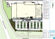
• A subdivision layout plan that provides for:<br />
• a high level of internal connectivity with a minimum of two road connections <strong>to</strong> <strong>the</strong><br />
south;<br />
DEVELOPMENT PLAN OVERLAY - SCHEDULE <strong>22</strong> PAGE 1 OF 2
WHITTLESEA PLANNING SCHEME<br />
• potential <strong>to</strong> accommodate bus access if required;<br />
• traditional pavement widths with provision for on street car parking.<br />
• Preparation of a bicycle and pedestrian network plan which includes links <strong>to</strong> <strong>the</strong><br />
established urban area <strong>to</strong> <strong>the</strong> south and <strong>the</strong> proposed Quarry Hills parkland.<br />
• Application of <strong>the</strong> principles of water sensitive urban design. A s<strong>to</strong>rmwater<br />
management plan must be prepared and submitted which provides for <strong>the</strong> protection of<br />
natural systems, integration of s<strong>to</strong>rmwater treatment in<strong>to</strong> <strong>the</strong> landscape, protection of<br />
water quality and reduction of runoff and peak flows.<br />
• A street tree masterplan.<br />
• Preparation of a site contamination assessment for <strong>the</strong> land <strong>to</strong> be transferred <strong>to</strong> Council<br />
for parkland purposes and <strong>the</strong> implementation of any recommendations arising from<br />
this assessment prior <strong>to</strong> <strong>the</strong> transfer of <strong>the</strong> land <strong>to</strong> Council.<br />
• Preparation of a program for <strong>the</strong> control and elimination of environmental weeds and<br />
<strong>the</strong> implementation of such works for <strong>the</strong> land <strong>to</strong> be transferred <strong>to</strong> Council for parkland<br />
purposes.<br />
• Incorporation of <strong>the</strong> water s<strong>to</strong>rage tank overflow drain and associated easement within<br />
<strong>the</strong> proposed subdivision.<br />
• Integration of <strong>the</strong> proposed subdivision with Council owned land <strong>to</strong> <strong>the</strong> south of <strong>the</strong><br />
subject land.<br />
• Provision for a visi<strong>to</strong>r access node(s) <strong>to</strong> <strong>the</strong> proposed parkland.<br />
• A conduit network concept plan <strong>to</strong> facilitate <strong>the</strong> future installation of advanced<br />
telecommunications services through fibre optical cabling.<br />
DEVELOPMENT PLAN OVERLAY - SCHEDULE <strong>22</strong> PAGE 2 OF 2