FORMER PORT PHILLIP WOOLLEN MILLS ADVISORY COMMITTEE
FORMER PORT PHILLIP WOOLLEN MILLS ADVISORY COMMITTEE
FORMER PORT PHILLIP WOOLLEN MILLS ADVISORY COMMITTEE

Create successful ePaper yourself
Turn your PDF publications into a flip-book with our unique Google optimized e-Paper software.
Planning and Environment Act 1987<br />
<strong>FORMER</strong> <strong>PORT</strong> <strong>PHILLIP</strong> <strong>WOOLLEN</strong> <strong>MILLS</strong><br />
<strong>ADVISORY</strong> <strong>COMMITTEE</strong><br />
Report of the Advisory Committee<br />
Pursuant to Section 151 of the Act<br />
10 MAY 2011
Planning and Environment Act 1987<br />
<strong>FORMER</strong> <strong>PORT</strong> <strong>PHILLIP</strong> <strong>WOOLLEN</strong> <strong>MILLS</strong><br />
<strong>ADVISORY</strong> <strong>COMMITTEE</strong><br />
Report of the Advisory Committee<br />
Pursuant to Section 151 of the Act<br />
John Keaney, Chair<br />
Bob Evans, Member<br />
Ann Keddie, Member<br />
10 MAY 2011
Contents<br />
Former Port Phillip Woollen Mills<br />
Report of the Advisory Committee – 10 May 2011<br />
EXECUTIVE SUMMARY ....................................................................................................6<br />
PART 1 – INTRODUCTION.............................................................................................18<br />
1. BACKGROUND.........................................................................................................19<br />
1.1 The Advisory Committee...........................................................................................19<br />
1.2 The subject site and surrounds..................................................................................20<br />
1.3 Amendment C75..........................................................................................................22<br />
1.4 The Development Plan ...............................................................................................23<br />
2. PROCEDURAL ISSUES............................................................................................24<br />
2.1 Notification...................................................................................................................24<br />
2.2 Hearings and Inspections...........................................................................................25<br />
2.3 Submissions..................................................................................................................25<br />
2.4 Preliminary Matters ....................................................................................................28<br />
2.4.1 Port and Environs Advisory Committee ...........................................................28<br />
2.4.2 Adjournment requests .......................................................................................29<br />
3. IDENTIFICATION OF ISSUES ..............................................................................37<br />
3.1 Summary of issues ......................................................................................................37<br />
3.2 Approach adopted by the Committee......................................................................37<br />
PART 2 – CONTEXT ..........................................................................................................39<br />
4. PLANNING POLICY.................................................................................................40<br />
4.1 What is the issue? ........................................................................................................40<br />
4.2 Policy framework ........................................................................................................40<br />
4.2.1 Ministerial Directions........................................................................................40<br />
4.2.2 Practice Notes....................................................................................................40<br />
4.2.3 State Planning Policy Framework .....................................................................41<br />
4.2.4 Metropolitan Policy...........................................................................................45<br />
4.2.5 Local Planning Policy Framework....................................................................45<br />
4.2.6 Other Strategic Documents ...............................................................................47<br />
4.3 Planning Scheme Controls .........................................................................................52<br />
4.3.1 Zones.................................................................................................................52<br />
4.3.2 Overlays ............................................................................................................52<br />
4.4 Discussion.....................................................................................................................53<br />
4.5 Conclusions ..................................................................................................................56<br />
5. SITE CONTEXT AND CHARACTER....................................................................57<br />
5.1 What is the issue? ........................................................................................................57<br />
5.2 Policy context of the issue ..........................................................................................57<br />
5.3 Evidence and submissions .........................................................................................58<br />
5.4 Discussion.....................................................................................................................60<br />
5.5 Conclusions ..................................................................................................................63<br />
6. HERITAGE FEATURES OF THE SITE AND AREA ..........................................64<br />
6.1 What is the issue? ........................................................................................................64<br />
6.2 Policy context of the issue ..........................................................................................64<br />
6.3 Evidence and submissions .........................................................................................65<br />
PAGE 1
Former Port Phillip Woollen Mills<br />
Report of the Advisory Committee – 10 May 2011<br />
6.4 Discussion.....................................................................................................................67<br />
6.5 Conclusions and recommendations..........................................................................69<br />
PART 3 - CONSTRAINTS ................................................................................................71<br />
7. BUFFER FROM HAZARDOUS FACILITIES.......................................................72<br />
7.1 What is the issue? ........................................................................................................72<br />
7.2 Policy context of the issue ..........................................................................................72<br />
7.3 Evidence and submissions .........................................................................................73<br />
7.4 Discussion.....................................................................................................................84<br />
7.5 Conclusions and recommendations..........................................................................88<br />
8. INTERFACE ISSUES - NOISE ................................................................................90<br />
8.1 What is the issue? ........................................................................................................90<br />
8.2 Policy context of the issue ..........................................................................................90<br />
8.3 Evidence and submissions .........................................................................................92<br />
8.4 Discussion.....................................................................................................................96<br />
8.5 Conclusions and recommendations..........................................................................97<br />
9. INTERFACE ISSUES - AIR EMISSIONS..............................................................98<br />
9.1 What is the issue? ........................................................................................................98<br />
9.2 Policy context of the issue ..........................................................................................98<br />
9.3 Evidence and submissions .........................................................................................98<br />
9.4 Discussion.....................................................................................................................99<br />
9.5 Conclusions ..................................................................................................................99<br />
10. TRAFFIC, PARKING, PUBLIC TRANS<strong>PORT</strong>...................................................100<br />
10.1 What is the issue? ......................................................................................................100<br />
10.2 Policy context of the issue ........................................................................................100<br />
10.3 Evidence and submissions .......................................................................................100<br />
10.4 Discussion...................................................................................................................106<br />
10.5 Conclusions and recommendations........................................................................110<br />
11. SOCIAL INFRASTRUCTURE...............................................................................112<br />
11.1 What is the issue? ......................................................................................................112<br />
11.2 Policy context of the issue ........................................................................................112<br />
11.3 Evidence and submissions .......................................................................................112<br />
11.4 Discussion...................................................................................................................115<br />
11.5 Conclusions and recommendations........................................................................119<br />
PART 4 – OP<strong>PORT</strong>UNITIES ..........................................................................................120<br />
12. URBAN DESIGN AND BUILT FORM................................................................121<br />
12.1 What is the issue? ......................................................................................................121<br />
12.2 Policy context of the issue ........................................................................................121<br />
12.3 Evidence and submissions .......................................................................................121<br />
12.4 Discussion...................................................................................................................125<br />
12.5 Conclusions and recommendations........................................................................136<br />
PART 5 – OUTCOMES ....................................................................................................137<br />
13. PLANNING CONTROL TOOLS..........................................................................138<br />
13.1 What is the issue........................................................................................................138<br />
PAGE 2
Former Port Phillip Woollen Mills<br />
Report of the Advisory Committee – 10 May 2011<br />
13.2 Policy context of the issue ........................................................................................138<br />
13.3 Evidence and submissions .......................................................................................139<br />
13.4 Discussion...................................................................................................................143<br />
13.5 Conclusions and recommendations........................................................................147<br />
14. RESPONSIBILITY AUTHORITY STATUS........................................................148<br />
14.1 What is the issue? ......................................................................................................148<br />
14.2 Policy context of the issue ........................................................................................148<br />
14.3 Evidence and submissions .......................................................................................148<br />
14.4 Discussion...................................................................................................................149<br />
14.5 Conclusion and Recommendations ........................................................................150<br />
15. OTHER ISSUES........................................................................................................152<br />
15.1 What other issues arose from submissions?..........................................................152<br />
15.2 Discussion...................................................................................................................152<br />
15.2.1 Zoning of the land ...........................................................................................152<br />
15.2.2 Planning controls on other land in Precinct 20................................................153<br />
15.2.3 Changes to other parts of the HBPS................................................................155<br />
15.2.4 Other Amenity Impacts ...................................................................................156<br />
15.2.5 Design Panel....................................................................................................157<br />
15.2.6 Coastal Sea Rise..............................................................................................158<br />
15.2.7 Tourism ...........................................................................................................159<br />
PART 6 – RECOMMENDATIONS ...............................................................................160<br />
16. CONCLUSIONS AND RECOMMENDATIONS ..............................................161<br />
Appendices<br />
Appendix 1 Terms of Reference...................................................................................167<br />
Appendix 2 List of submitters......................................................................................173<br />
Appendix 3 List of documents .....................................................................................180<br />
Appendix 4 Committee Timetable...............................................................................191<br />
Appendix 5 Committee Preferred DDO .....................................................................199<br />
Appendix 6 Committee Recommended Rezoning...................................................207<br />
PAGE 3
Abbreviations<br />
BAE BAE Systems Australia<br />
BV Bureau Veritas<br />
CBD Central Business District<br />
DDO Design and Development Overlay<br />
DPO Development Plan Overlay<br />
Former Port Phillip Woollen Mills<br />
Report of the Advisory Committee – 10 May 2011<br />
DPCD Department of Planning and Community Development<br />
DPZ Development Proximity Zone<br />
EAO Environmental Audit Overlay<br />
EPA Environmental Protection Agency<br />
HBCC Hobsons Bay City Council<br />
HBPS Hobsons Bay Planning Scheme<br />
HSE Health and Safety Executive<br />
HO Heritage Overlay<br />
ILMS Industrial Land Management Strategy 2008<br />
kPa Kilopascal<br />
LPP Local Planning Policy<br />
LPPF Local Planning Policy Framework (MSS/Local Planning<br />
Policies)<br />
M2030 Melbourne 2030<br />
MHF Major Hazard Facility<br />
MoH Ministry of Housing<br />
MSS Municipal Strategic Statement<br />
NPV Nelson Place Village Pty Ltd<br />
OHS Occupational Health and Safety<br />
PADHI Planning Advice for Developments near Hazardous<br />
Installations<br />
PEAC Port and Environs Advisory Committee<br />
PGTF Port Gellibrand Tank Farm<br />
PAGE 4
PoM Port of Melbourne<br />
PoW Preserve Old Williamstown<br />
PPV Planning Panels Victoria<br />
Former Port Phillip Woollen Mills<br />
Report of the Advisory Committee – 10 May 2011<br />
PPWMAC Port Phillip Woollen Mills Advisory Committee<br />
QRA Quantitative Risk Assessment<br />
R1Z Residential 1 Zone<br />
Section<br />
173<br />
Legal Agreement – Section 173 Planning and Environment Act<br />
SEPP State Environment Protection Policy<br />
SRA Strategic Redevelopment Area<br />
SW Save Williamstown<br />
SPPF State Planning Policy Framework<br />
SUZ Special Use Zone<br />
UK United Kingdom<br />
VPD Vehicles per day<br />
VPH Vehicles per hour<br />
WREIDS Western Region Employment and Industrial Development<br />
Strategy<br />
WNSRA Williamstown, Newport and Spotswood Residents<br />
Association<br />
PAGE 5
Executive Summary<br />
Former Port Phillip Woollen Mills<br />
Report of the Advisory Committee – 10 May 2011<br />
The former Minister for Planning approved Amendment C75 to the Hobsons<br />
Bay Planning Scheme in April 2010. This amendment rezoned the former<br />
Port Phillip Woollen Mills site on Nelson Place Williamstown from an<br />
Industrial 1 Zone to the Residential 1 Zone and applied an Environmental<br />
Audit Overlay. This site is owned by Nelson Place Village Pty Ltd (NPV)<br />
and is referred to as the NPV land.<br />
Other nearby land was retained within either the Residential 1 Zone,<br />
Industrial 1 Zone or the Industrial 3 Zone.<br />
There are two existing Design and Development Overlays affecting parts of<br />
the land (DDO4 and DDO8) restricting building height to 2 storeys (DDO4)<br />
and 3 storeys (DDO8). At present, a permit may not be granted for<br />
development to exceed these heights.<br />
The NPV site abuts Point Gellibrand Coastal Heritage Park, which was the<br />
first point of European settlement in the Port Phillip Region. Accordingly the<br />
site and its surrounds are covered by several heritage overlays addressing<br />
historical use of the land as well as built form. The NPV land is directly<br />
affected by nine Heritage Overlays.<br />
As part of Amendment C75, NPV provided Council with an indicative<br />
development proposal for the subject land which would yield 412 dwellings,<br />
including 328 apartments and 84 townhouses. The buildings in the<br />
indicative plan varied in height from three to thirteen storeys.<br />
This proposal was not supported by Hobsons Bay City Council at its meeting<br />
on 1 December 2009.<br />
Nevertheless, the former Minister for Planning rezoned the NPV land in<br />
April 2010 to the Residential 1 Zone.<br />
An Advisory Committee (the ‘Committee’) was appointed by the former<br />
Minister for Planning on 27 May 2010 to advise on planning and urban<br />
design matters related to the proposed redevelopment of the NPV land and<br />
its surrounds. This wider area is referred to as the ‘review land’.<br />
The Terms of Reference of the Committee specify the following task:<br />
PAGE 6
Former Port Phillip Woollen Mills<br />
Report of the Advisory Committee – 10 May 2011<br />
The Advisory Committee is to assess the planning and built form/urban<br />
design opportunities for the subject land (Part Precinct 20 to the south of<br />
Nelson Place) taking into account:<br />
· The locational considerations of the subject land, the northern section<br />
of Precinct 20 and general surrounds;<br />
· The appropriateness of the current planning framework and<br />
planning controls applying to the subject land (policy, design and<br />
development overlays, heritage overlays, responsible authority<br />
status) and<br />
· The scope for varying the existing planning framework and planning<br />
controls in relation to the subject land, having regard to appropriate<br />
heights, setbacks, articulation, walkability, traffic, infrastructure<br />
impacts, heritage asset protection, acoustic and risk treatments, open<br />
space requirements and the need for development contributions.<br />
The Committee invited submissions from interested parties and it received<br />
146 submissions (including late submissions) expressing an interest in the<br />
planning and urban design of the precinct having regard to the matters set<br />
out in the Terms of Reference.<br />
The Committee is required to provide a report to the Minister for Planning<br />
on the appropriate form of planning controls for the subject land based on its<br />
consideration of the relevant issues canvassed in submissions.<br />
Based on its assessment of submissions, the Committee makes the following<br />
comments on the key issues.<br />
Planning Policy<br />
The Committee notes that at the state and metropolitan level, the principles<br />
of Melbourne 2030 encourage residential intensification within established<br />
residential areas to encourage more effective use of infrastructure including<br />
public transport, social and community facilities, activity centres and other<br />
services that improve the liveability of the city.<br />
The Committee accepts that the proposal is consistent with this direction as it<br />
is located near an Activity Centre, within proximity of public transport and<br />
proposes development within the Council designated redevelopment area.<br />
A key strategic objective of sustainable development within Melbourne is to<br />
encourage a greater proportion of new dwellings at strategic redevelopment<br />
sites within established metropolitan urban areas, to reduce pressure for<br />
urban expansion.<br />
PAGE 7
Former Port Phillip Woollen Mills<br />
Report of the Advisory Committee – 10 May 2011<br />
The Committee accepts that the Industrial Land Management Strategy 2008<br />
(ILMS) is the foundation local strategic document upon which the<br />
Committee can rely. The ILMS supports a mixed use residential<br />
development on the NPV site. It is apparent that the ILMS was a thorough<br />
analysis of the competing interests in relation to industrial land in the<br />
municipality and it has had wide ranging consultation.<br />
The Committee therefore considers that state and local policy bring<br />
expectations of denser development of the review land. However, this<br />
expectation needs to be tempered by acknowledging the other policy<br />
constraints within the precinct including a working shipyard and other<br />
industries. The Committee does not think that the urban consolidation<br />
imperative of the planning scheme means that every site should be<br />
developed to its absolute maximum. The Committee agrees that Clause<br />
10.04 of the planning scheme does not mean ‘development at all costs’<br />
especially in the context of other state directions which require consideration<br />
of a ‘net community benefit’.<br />
Site Context and Character<br />
The Committee considers that the NPV site and the immediate area are in<br />
urgent need of urban renewal. The area was universally acknowledged as<br />
being of importance (in varying degrees) to Williamstown, Melbourne,<br />
Victoria and Australia. In that context, a disused industrial site housed in a<br />
bland utilitarian building opposite a large surface car park represents a very<br />
‘poor return’ for a site of such significance.<br />
The Committee accepts that despite the dominance of low scale Victorian<br />
buildings in Williamstown (mainly residential) the character of the<br />
immediate area is the sum of a number of quite disparate parts including:<br />
� that Victorian built form;<br />
� its seaside setting;<br />
� the Hoddle grid with its wide streets;<br />
� its maritime history that still manifests itself in a strong ship building<br />
presence;<br />
� clear permeability throughout the suburb;<br />
� the presence of some other industries which have a relationship with the<br />
maritime industry.<br />
The Committee acknowledges that the design in the development plan<br />
adopts the characteristic typology of about a three storey built form around<br />
the street edges including Nelson Place, Kanowna Street and Ann Street. In<br />
that sense, the Committee accepts that the proposed ‘podium base’ to the<br />
design is characteristic of the area and is acceptable.<br />
PAGE 8
Former Port Phillip Woollen Mills<br />
Report of the Advisory Committee – 10 May 2011<br />
However, the Committee also agrees with many of the community<br />
submitters that there is a strong ‘horizontal’ theme to the built form on the<br />
Williamstown peninsula. This is brought about by a long established pattern<br />
of one and two storey houses set on wide streets. There is a spaciousness to<br />
Williamstown that is rarely found elsewhere in metropolitan Melbourne.<br />
Without question there are exceptions to this including industrial buildings,<br />
ship masts, and the MoH towers of the 1960s, but overall the Committee<br />
accepts those submissions that referred to the ‘village’ or ‘country town’ feel<br />
of Williamstown.<br />
The Committee thinks that this horizontal characteristic of Williamstown can<br />
be accommodated on a very big and wide site such as this with heights<br />
greater than the existing allowable heights of two or three storeys. However,<br />
the Committee also thinks that beyond a certain height, that horizontal<br />
character will be lost. The Committee considers that beyond about 25 metres<br />
(and on a site of this width) buildings inevitably assume a more ‘vertical’<br />
emphasis. In the view of the Committee this would be ‘uncharacteristic’ of<br />
Williamstown and would be in conflict with the ‘village’ feel of the suburb.<br />
The Committee therefore concludes that a strong podium base with some<br />
taller and spaced elements will respect the site context and neighbourhood<br />
character of Williamstown.<br />
Heritage<br />
The Committee considers that the relative isolation of the NPV site and its<br />
location at the edge of Williamstown gives it a lower ‘redevelopment’<br />
sensitivity than other sites in Williamstown. On this basis, a more robust<br />
urban design solution can certainly be considered. In other words, within its<br />
heritage context, this is one of the few sites in Williamstown that provides an<br />
opportunity for a higher built form which does not impact on the undeniable<br />
but different heritage qualities of other parts of Williamstown.<br />
The Committee considers that any proposal should be able to meet the<br />
heritage challenges in the planning scheme so as to become a valued addition<br />
to Williamstown. With respect to heritage, the Committee concludes that:<br />
� development per se will not diminish the heritage values of the<br />
Government Survey Heritage Precinct or Williamstown at large;<br />
� heritage issues are not determinative in generating urban design and built<br />
form outcomes for this site. The site will inevitably generate a scale and<br />
type of development atypical of, say, Cecil Street; and<br />
� the Guidelines for Infill Development in Heritage Areas in Hobsons Bay are<br />
useful where detailed design is proposed, and should be referred to in the<br />
control for the land.<br />
PAGE 9
Buffer from hazardous facilities<br />
Former Port Phillip Woollen Mills<br />
Report of the Advisory Committee – 10 May 2011<br />
The Committee has adopted a precautionary yet pragmatic approach to the<br />
critical safety issue of an appropriate displacement from the Point Gellibrand<br />
Tank Farm. The Committee has adopted the WorkSafe Advisory Note of<br />
September 2010 as the most appropriate guide. The Committee is reluctant<br />
to ignore the advice of the state government agency that has responsibility<br />
for Major Hazard Facilities. The WorkSafe Advisory Note was only<br />
published in September 2010 and it reflects the most up to date analysis of<br />
overseas experience including the devastating ‘Buncefield’ incident in the<br />
United Kingdom.<br />
The Committee can only support a reduced level of residential development<br />
within the WorkSafe ‘outer area’ along the eastern edge of the site.<br />
Specifically, the Committee is of the view that the ‘balanced’ outcome with<br />
respect to the safety issue is that of lower density development along the<br />
Kanowna Street frontage. Any higher built form should be located entirely<br />
to the west of the WorkSafe ‘outer area’ buffer.<br />
Interface with non‐residential uses – Noise<br />
The Committee accepts that the ‘reverse buffer’ principle is already<br />
embedded in the Hobsons Bay Planning Scheme at Clause 21.06‐3. The<br />
Committee agrees that measures will be needed to ensure that new<br />
residential development on the NPV site is in compliance with SEPP N‐1 to<br />
protect noise. It also agrees with NPV that a testing and compliance regime<br />
needs to be included in any planning control and that it would be its<br />
responsibility to build the development in accordance with those controls.<br />
The Committee sees no need for BAE Systems Australia (BAE) to be a<br />
‘referral authority’ for future applications as there will be an agreed position,<br />
reflected in the planning control, as to the standards that are to be met for<br />
any future development on the site. That said, the views of BAE should be<br />
considered as part of any future application.<br />
Interface with non‐residential uses ‐ Air Emissions<br />
The Committee considers that the operations at Mobil and BAE will not be a<br />
threat to the air environment at the NPV site.<br />
Traffic, parking and public transport<br />
The Committee is satisfied that the traffic and parking issues associated with<br />
the NPV development have been adequately addressed subject to inclusion<br />
of parking requirements and infrastructure upgrades being specified in the<br />
planning control.<br />
PAGE 10
Former Port Phillip Woollen Mills<br />
Report of the Advisory Committee – 10 May 2011<br />
In particular, the Committee is satisfied that the traffic generated by the<br />
proposed development can be adequately catered for without placing undue<br />
stress on the local and regional road network.<br />
Social infrastructure<br />
The Committee acknowledges the community concerns about the ‘near<br />
capacity’ provision of social infrastructure in Williamstown. While this is<br />
clearly a pressing local issue, the Committee considers that this is little<br />
different from other parts of metropolitan Melbourne. State and local<br />
government are responsible for the provision of such infrastructure, not<br />
individual ratepayers. The Committee is heartened by the degree to which<br />
Hobsons Bay City Council is identifying and quantifying its community<br />
needs. The Committee is mindful of the need for affordable housing across<br />
Melbourne and urges the Minister for Planning to consider statutory<br />
innovations such as ‘inclusionary zoning’ to help redress this pressing issue.<br />
Urban Design and Built Form<br />
In the context of its consideration of the characteristics of the area, the<br />
Committee considers that buildings up to 15 storeys as proposed on the NPV<br />
site would offend the flat and horizontal nature of the Williamstown<br />
peninsula. This is a strong and defining characteristic of this part of<br />
Williamstown. The Committee believes that this is determinant to its<br />
assessment. Whatever the design or the new character for the site, elements<br />
of 15 storeys would be discordant in the South Williamstown setting. The<br />
Committee accepts a ‘podium’ base of at least 10 metres, above which four<br />
taller elements of no more than 25 metres are appropriate.<br />
Responsible Authority status<br />
All parties agreed that the site is important and the Committee thinks that<br />
the Minister for Planning must take responsibility for the ultimate decision.<br />
The Committee therefore considers that the Minister for Planning should be<br />
the Responsible Authority for deciding whether or not to grant a permit.<br />
There should be no avenue for review from his decision provided to any<br />
party other than the applicant.<br />
Planning control options<br />
The Committee accepts that when contemplating the choice between a<br />
Development Plan Overlay (DPO) and a Design and Development Overlay<br />
(DDO), the question to be asked is ‘…does the future development of this land<br />
require further third party scrutiny?”. The Committee does not consider that<br />
there is sufficient definition in the plans provided for any third party to have<br />
the confidence to know exactly what is proposed.<br />
PAGE 11
Former Port Phillip Woollen Mills<br />
Report of the Advisory Committee – 10 May 2011<br />
The Committee is concerned that NPV’s desire for flexibility disqualifies the<br />
DPO option as that option could only ever be contemplated if there was such<br />
a level of certainty in the plans and such a level of public ventilation of those<br />
plans as to warrant excluding third parties. There is no such certainty in this<br />
proposal.<br />
However, given that the redevelopment of the NPV land has been explored<br />
for a number of years, the Committee accepts that a more refined version of<br />
public consultation is appropriate. The Committee will specify in the<br />
planning control those parties whom the Minister for Planning (as<br />
Responsible Authority) must seek ‘the views of’ in determining the matter.<br />
The Committee has analysed the use of mandatory height controls in new<br />
format planning schemes and a large number of panel reports which have<br />
addressed this issue. While the common theme in all of these reports is that<br />
mandatory controls are the exception, such exceptions are certainly evident<br />
within the Victorian system and are typically to be found in areas of<br />
consistently high heritage value, strong and consistent character themes, or<br />
in sensitive environmental locations such as along the coast. In the view of<br />
the Committee this part of Williamstown is one such area.<br />
Zoning of the land<br />
The Committee notes that while many submissions have opposed the<br />
rezoning of the land to Residential 1 (preferring a Mixed Use Zone), it is clear<br />
that its Terms of Reference specify that this is not part of its tasks. However,<br />
the findings of the Committee on the issues of risk, safety and interface as<br />
discussed in this report logically raise doubts as to the zoning of the land.<br />
The Committee notes that one of the most defining elements in its<br />
consideration is the WorkSafe Advisory Note which was only issued in<br />
September 2010, about five months after the decision to rezone the land to<br />
residential. Armed with that advice, and mindful of its other<br />
recommendations, it seems to the Committee that an alternative outcome<br />
might have been for a ‘skin’ of lower intensity commercial premises facing<br />
onto Kanowna Street and possibly parts of Nelson Place adjacent to the<br />
Titanic theatre restaurant. These premises could include some small retail,<br />
community, commercial or health related facilities.<br />
The Committee appreciates that these observations are outside its Terms of<br />
Reference but it brings them to the attention of the Minister for Planning in<br />
light of the numerous submissions on this issue and on the change in<br />
circumstances since the land was rezoned.<br />
PAGE 12
Planning controls on other land in Precinct 20<br />
Former Port Phillip Woollen Mills<br />
Report of the Advisory Committee – 10 May 2011<br />
The Committee is to review planning and urban design matters related to the<br />
proposed redevelopment not only of the former Port Phillip Woollen Mills<br />
site but also of land to the south of Nelson Place known as ‘Precinct 20’. The<br />
Committee considers that all of the ‘review land’ (other than the NPV site<br />
and the Titanic site) be rezoned to Residential 1. The Committee also<br />
considers that the Titanic site should be rezoned to Business 1. The<br />
Committee also considers that an Environmental Audit Overlay and a<br />
Design and Development Overlay be applied to all of the review land.<br />
Changes to other parts of the Hobsons Bay Planning Scheme (HBPS)<br />
The most significant recommendation of the Committee (in a planning<br />
control sense) is for a modified DDO which is already addressed in the<br />
Municipal Strategic Statement (MSS). The Committee is satisfied that any<br />
other consequential changes can be left until the next routine review of the<br />
Hobsons Bay Planning Scheme. The only exception to this is the need to<br />
delete Character Area No. 5 in Clause 22.10 from all of the review land so<br />
that the preferred character statement does not apply to the NPV site and its<br />
abuttals given that a ‘new character’ will emerge from this redevelopment.<br />
Other Amenity Impacts<br />
The Committee is satisfied that there will be limited off‐site amenity affects<br />
of the proposal. The Committee rejects those submissions claiming that the<br />
winter solstice was the appropriate sunlight test. In a settled urban area,<br />
concepts of ‘balance’ and ‘acceptable outcomes’ are enshrined in the Planning<br />
and Environment Act and the Hobsons Bay Planning Scheme. These concepts<br />
are fundamental to sound and orderly planning. The Committee believes<br />
that the equinox sunlight test best balances the reasonable expectations of<br />
residents and the demands of urban consolidation.<br />
Design Panel<br />
The Committee sees great merit in an independent overview of a project of<br />
this size, irrespective of the planning mechanisms employed to deliver it.<br />
The Committee has included reference to the Design Panel in its modified<br />
planning control.<br />
Coastal Sea Rise<br />
The Committee agrees with Council that coastal sea rise is an important<br />
matter that should be addressed at the planning permit stage. On this basis,<br />
the Committee will include the requirement for a Coastal Hazard<br />
Vulnerability Assessment to form part of the planning control.<br />
PAGE 13
Tourism<br />
Former Port Phillip Woollen Mills<br />
Report of the Advisory Committee – 10 May 2011<br />
A number of submitters advised that many of the traffic and parking ills of<br />
Williamstown were due to its tourist destination. This is brought about by<br />
the coastal park, the attraction of Nelson Place eateries and the new<br />
Seaworks project nearby. The Committee considers that the redevelopment<br />
of the review land will not hinder the tourist potential of the area especially<br />
as on‐site car parking is adequately catered for on the NPV site.<br />
Process<br />
The Committee envisages the following planning process:<br />
� The Minister for Planning be the Responsible Authority for all of the<br />
review land.<br />
� The review land be included in the Residential 1 Zone, other than the<br />
Titanic Restaurant site which is to be rezoned to Business 1.<br />
� The NPV land be included in a new DDO.<br />
� The DDO be extended to all other sites in the precinct.<br />
� The new DDO will trigger a buildings and works permit.<br />
� The new DDO will contain a ‘Design and Development Plan’ and ‘Built<br />
Form Outcomes’ for the five precincts within the review land.<br />
� The new DDO will contain mandatory height controls which cannot be<br />
exceeded in any of the precincts.<br />
� The new DDO will list all of the parties whose ‘views’ the Minister will<br />
seek including Hobsons Bay City Council, Port of Melbourne, BAE, EPA,<br />
Mobil, WorkSafe, adjoining and abutting landowners.<br />
� The new DDO will require that the Minister for Planning establish a<br />
Design Review Panel set up in accordance with Development Assessment<br />
Committee (DAC) protocols and made up of:<br />
- the State Architect (or nominee) who will Chair the Panel;<br />
- proponent representatives (two architects/urban designers);<br />
- Council representatives (two parties one of whom has<br />
expertise in urban design and/or architecture);<br />
- community representatives (two parties one of whom has<br />
expertise in urban design and/or architecture); and<br />
- Department of Planning and Community Development<br />
(DPCD) representatives (two parties both of whom have<br />
expertise in urban design and/or architecture).<br />
� The Design Review Panel is to directly report to the Minister for Planning<br />
within a time frame to be determined by the Minister.<br />
PAGE 14
Former Port Phillip Woollen Mills<br />
Report of the Advisory Committee – 10 May 2011<br />
� The only right of review of a decision of the Minister for Planning will be<br />
for refusal (under Section 77 of the Act) or against conditions (under<br />
Section 80 of the Act).<br />
**********<br />
Finally, the Committee refers to the three specific tasks in its Terms of<br />
Reference and it makes the following comments in respect of each of them:<br />
Task 1: The locational considerations of the subject land, the northern<br />
section of Precinct 20 and general surrounds.<br />
This is a precinct urgently in need of redevelopment and some form of a<br />
residential outcome is the best use of the land. The site has a peculiar mix of<br />
interfaces ranging from robust industrial built form on one side, to an open<br />
air car park on another, to a windswept coastal park of undoubted historic<br />
significance, to low rise Victorian cottages and to modern residential town<br />
houses. The same precinct hosts a working shipyard of state significance, a<br />
crude oil tank farm, a late night entertainment venue, remnant light<br />
industrial uses and an attractive residential neighbourhood.<br />
The Committee concludes that that locational context lends itself to a denser<br />
form of development than currently allowed by the existing planning<br />
controls.<br />
Task 2: The appropriateness of the current planning framework and<br />
planning controls applying to the subject land (policy, design<br />
and development overlays, heritage overlays, responsible<br />
authority status).<br />
The existing choice of planning control applying to the precinct is considered<br />
appropriate. That said, the detail of the DDOs need substantial modification<br />
to accord with the other Committee recommendations. The Committee<br />
considers that the DDO is the best tool to apply to influence the built form<br />
outcomes suggested by the Committee. The DDO enables standards and<br />
requirements to be specified including height, setbacks and application<br />
requirements.<br />
A DPO as suggested by NPV is not an option for the Committee. Given that<br />
the lack of precision in the design outcomes, the Committee concludes that<br />
parties will be disenfranchised from a proposal about which they presently<br />
do not have enough information. The existing heritage overlay is<br />
appropriate to retain although Council should reconsider this when next<br />
reviewing its planning scheme. The Committee suggests that there will need<br />
to be some minor consequential changes to Clause 22.10.<br />
PAGE 15
Former Port Phillip Woollen Mills<br />
Report of the Advisory Committee – 10 May 2011<br />
The Committee supports the Minister for Planning being the Responsible<br />
Authority for the assessment and decision on the ultimate development of<br />
the review land.<br />
The Committee concludes that that the existing planning controls on the site<br />
be retained in a modified form with the Minister for Planning as the<br />
Responsible Authority.<br />
Task 3: The scope for varying the existing planning framework and<br />
planning controls in relation to the subject land, having regard<br />
to appropriate heights, setbacks, articulation, walkability,<br />
traffic, infrastructure impacts, heritage asset protection, acoustic<br />
and risk treatments, open space requirements and the need for<br />
development contributions.<br />
Having considered appropriate heights, setbacks, articulation, walkability,<br />
traffic, infrastructure impacts, heritage asset protection, acoustic and risk<br />
treatments, open space requirements and the need for development<br />
contributions, the Committee supports redevelopment of the NPV site. Its<br />
preference is for development of between 10 and 13 metres in height along<br />
Nelson Place and Kanowna Street; with development of up to only 10 metres<br />
on the more sensitive Ann and Cecil Streets. Within the NPV site, the<br />
Committee supports development of up to 25 metres but such development<br />
must be outside the WorkSafe ‘outer advisory area’. Buildings must also be<br />
treated with sound attenuation measures to address the nearby working<br />
shipyard.<br />
The Committee supports the concept of a series of laneways running through<br />
the site to improve permeability and it suggests that ‘open’ areas be provided<br />
on the public realm around the site to help emphasise important places of<br />
gathering. The Committee supports a community infrastructure levy of<br />
$900/dwelling, a community meeting room of 100m2 and a small<br />
convenience shop. The Committee considers that at the time of subdivision,<br />
the 5% site area open space levy be totally applied to the adjoining heritage<br />
coastal park.<br />
**********<br />
The Committee concludes that a development in accordance with these<br />
parameters will be generally consistent with the foundation strategic<br />
research for this area as expressed in Council’s Industrial Land Management<br />
Strategy 2008. Such an outcome will make a substantial contribution to<br />
metropolitan urban consolidation policy while protecting character, safety,<br />
amenity and industrial interfaces.<br />
The Committee thanks all parties for their submissions and presentations.<br />
PAGE 16
Former Port Phillip Woollen Mills<br />
Report of the Advisory Committee – 10 May 2011<br />
The Committee especially thanks its project officers Ms Eastaugh and Ms<br />
Cutting for their assistance throughout the process.<br />
The Committee is particularly grateful to the City of Hobsons Bay for its<br />
assistance in hosting numerous days of the hearing.<br />
PAGE 17
Part 1 – Introduction<br />
Former Port Phillip Woollen Mills<br />
Report of the Advisory Committee – 10 May 2011<br />
PAGE 18
1. Background<br />
1.1 The Advisory Committee<br />
Former Port Phillip Woollen Mills<br />
Report of the Advisory Committee – 10 May 2011<br />
An Advisory Committee (the ‘Committee’) was appointed by the former<br />
Minister for Planning under to Section 151 of the Planning and Environment<br />
Act 1987. The Committee was asked to review planning and urban design<br />
matters relating to the proposed redevelopment of the former Port Phillip<br />
Woollen Mills, Nelson Place in Williamstown. The Committee was also<br />
asked to review planning and urban design matters relating to the land to the<br />
south of Nelson Place, within Precinct 20 as identified under the Hobsons Bay<br />
Industrial Land Management Strategy 2008.<br />
The Committee consisted of:<br />
� Chairperson: John Keaney (with expertise in statutory and strategic<br />
planning);<br />
� Member: Ann Keddie (with expertise in architecture, urban<br />
design and heritage); and<br />
� Member: Bob Evans (with expertise in civil engineering and<br />
urban planning).<br />
The Committee was greatly assisted by its project officers, Ms Briana<br />
Eastaugh and Ms Jessica Cutting.<br />
Terms of Reference<br />
The Committee’s Terms of Reference require it to assess, among other things,<br />
the planning and built form/urban design opportunities for the subject land<br />
(Part Precinct 20 to the south of Nelson Place) taking into account:<br />
� The locational considerations of the subject land, the northern section of<br />
Precinct 20 and general surrounds;<br />
� The appropriateness of the current planning framework and planning<br />
controls applying to the subject land (policy, design and development<br />
overlays, heritage overlays, responsible authority status); and<br />
� The scope for varying the existing planning framework and planning<br />
controls in relation to the subject land, having regard to appropriate<br />
heights, setbacks, articulation, walkability, traffic, infrastructure impacts,<br />
heritage asset protection, acoustic and risk treatments, open space<br />
requirements and the need for development contributions.<br />
PAGE 19
Former Port Phillip Woollen Mills<br />
Report of the Advisory Committee – 10 May 2011<br />
The former Minister for Planning rezoned the former Port Phillip Woollen<br />
Mills land to Residential 1 Zone as part of Amendment C75 to the Hobsons<br />
Bay Planning Scheme in April 2010. The Terms of Reference make it clear<br />
that a review of this rezoning was not to form part of the Committee’s tasks.<br />
The Terms of Reference are attached as Appendix 1 to this report.<br />
1.2 The subject site and surrounds<br />
The Committee is to review the planning and urban design matters related to<br />
the proposed redevelopment of the former Port Phillip Woollen Mills,<br />
Nelson Place, Williamstown. This land is owned by Nelson Place Village<br />
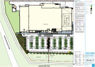
Pty. Ltd and will be referred to as the ‘NPV’ land. The NPV land is marked<br />
in black in Figure 1.<br />
The Committee is also to review the land to the south of Nelson Place, within<br />
Precinct 20 as identified under the Hobsons Bay Industrial Land Management<br />
Strategy 2008. This land and the NPV land together will be referred to as the<br />
‘review land’ and is shown marked in red in Figure 1.<br />
Figure 1 NPV Land (Black) and Review Land (Red)<br />
PAGE 20
Former Port Phillip Woollen Mills<br />
Report of the Advisory Committee – 10 May 2011<br />
The review land is located towards the eastern end of the Williamstown<br />
peninsula and is about 7.5 kilometres south‐west of the Melbourne Central<br />
Business District.<br />
While the review land does not strictly align to the north, for ease of<br />
reference throughout this report, the Committee will refer to Nelson Place as<br />
being to the north, Kanowna Street to the east, Ann Street to the west and<br />
Cecil Street to the south.<br />
The review land contains a mix of the Residential 1 Zone, the Industrial 1<br />
Zone and the Industrial 3 Zone. There are two existing Design and<br />
Development Overlays affecting parts of the subject land, DDO4 and DDO8.<br />
These overlays restrict building height to two storeys (DDO4) and three<br />
storeys (DDO8). At present, a permit may not be granted for development to<br />
exceed these heights.<br />
The review land is also directly affected by the following Heritage Overlays:<br />
� HO1 – Cecil Street Precinct<br />
� HO8 – Government Survey Precinct<br />
� HO35 – the former Port Phillip Stevedore Club Hall<br />
� HO43 – the former Telegraph Hotel<br />
� HO162 – the former Britannia Hotel<br />
� HO210 – the former Prince of Wales Hotel<br />
� HO211 – the former Oriental Hotel<br />
The land abuts Point Gellibrand Coastal Heritage Park, which was the first<br />
point of European settlement in the Port Phillip Region. Accordingly, the<br />
review land and its surrounds are covered by several heritage overlays<br />
addressing historical use as well as built form.<br />
The land uses on and surrounding the precinct include:<br />
� Disused industrial land being the former Port Phillip Woollen Mills site.<br />
� The BAE shipbuilding facility to the north, over Nelson Place.<br />
� A combination of industrial and some residential development on Aitken<br />
Street.<br />
� Victorian era residential development on Cecil Street to the south.<br />
� The Titanic Theatre Restaurant on the north west corner of Nelson Place<br />
and Kanowna Street.<br />
� A large triangular open lot car park to the east of Kanowna Street,<br />
currently owned and utilised by BAE.<br />
� The Point Gellibrand Coastal Heritage Park is further east.<br />
PAGE 21
Former Port Phillip Woollen Mills<br />
Report of the Advisory Committee – 10 May 2011<br />
� The Mobil Tank Farm (MTF) at Point Gellibrand about 300m to the north<br />
east which hosts a number of crude oil storage tanks.<br />
1.3 Amendment C75<br />
On 27 March 2009, Hobsons Bay City Council (HBCC) received a request for<br />
a planning scheme amendment from Nelson Place Village Pty Ltd. The<br />
amendment (Amendment C75 to the Hobsons Bay Planning Scheme),<br />
proposed to:<br />
� Remove the existing Design and Development Overlays, DDO4 and<br />
DDO8;<br />
� Rezone land at 3‐59 Nelson Place, part of 2‐10 Nelson Place (located along<br />
Kanowna Street) and 16‐20 Kanowna Street from an Industrial 1 Zone<br />
(IN1Z) and Special Use Zone 5 (SUZ5) to Residential 1 Zone (R1Z);<br />
� Introduce a Development Plan Overlay 1 (DPO1 – Former Industrial Area,<br />
Nelson Place, Williamstown) to control the redevelopment of the site; and<br />
� Apply an Environmental Audit Overlay (EAO) to address the<br />
contamination and remediation of the site.<br />
As part of the request, the proponent submitted amendment documentation<br />
and planning related reports in support of Amendment C75.<br />
At its meeting on 1 December 2009, HBCC resolved not to support the<br />
preparation and exhibition of Amendment C75. Its basis for rejection<br />
included inconsistencies with the State and Local Planning Policy<br />
Framework; failure to justify the removal of DDO4 and DDO8; and failure to<br />
address protection of the adjoining state significant port and ship building<br />
operations.<br />
The Council report of December 2009 acknowledged that the proposed<br />
rezoning of the site to a residential zone was supported by a number of<br />
strategies and polices as set out within the Hobsons Bay Planning Scheme.<br />
Further, the report considered it worthwhile that further options for the<br />
redevelopment of the site be explored and that NPV be given an opportunity<br />
to respond to the issues.<br />
On 1 April 2010, the former Minister for Planning approved Amendment C75<br />
under section 20(4) of the Planning and Environment Act 1987. The<br />
Explanatory Report for the Amendment noted that it was prepared by that<br />
Minister for Planning at the request of Nelson Place Village Pty Ltd.<br />
Through Amendment C75, the former Port Phillip Woollen Mills site was<br />
rezoned to Residential 1 Zone and an Environmental Audit Overlay was<br />
applied. Amendment C75 made no changes to the existing Design and<br />
Development Overlays or the Heritage Overlay controls affecting the site.<br />
PAGE 22
Former Port Phillip Woollen Mills<br />
Report of the Advisory Committee – 10 May 2011<br />
On 27 May 2010, the former Minister for Planning appointed this Advisory<br />
Committee to assess the planning, built form and urban design opportunities<br />
for the subject land.<br />
1.4 The Development Plan<br />
The Terms of Reference state that a review of the residential rezoning did not<br />
form part of the Committee’s tasks. The Terms of Reference also made it<br />
clear that the Committee was not to consider a specific proposal. That said,<br />
the development plans of August 2010 were available for all of the parties to<br />
comment on and a brief summary of those plans was provided by Mr Clarke,<br />
on behalf of NPV, as follows:<br />
The main features of the proposal will be the comprehensive<br />
redevelopment of the site to provide some 451 new dwellings comprising<br />
350 apartments in four higher density buildings and 93 three‐storey<br />
townhouses.<br />
It is contemplated that the former Williamstown Hotel will be retained in<br />
part.<br />
A number of new public streets are proposed to be created to connect<br />
with the surrounding street network.<br />
Four apartment buildings are proposed known as Buildings 1‐4.<br />
Building 1 will extend to 3 storeys at both its street frontages<br />
commensurate with the former Williamstown Hotel facade which will<br />
serve as a podium above which a further 4 storeys (total: 7 storeys) are<br />
proposed.<br />
Building 2 is to be located centrally within the site between a new local<br />
street parallel to and south of Nelson Place. It will extend to a total<br />
height of 9 storeys (including a 2 level podium).<br />
Buildings 3 and 4 front Kanowna Street. Building 3 comprises 13<br />
storeys (including a 3 level podium) whilst Building 4 comprises 9<br />
storeys (including a 3 level podium).<br />
To implement this into the Hobsons Bay Planning Scheme, NPV proposes to<br />
remove the existing Design and Development Overlays from the land (DDO4<br />
and DDO8) and to replace them with a Development Plan Overlay 1 (DPO1 –<br />
Former Industrial Area, Nelson Place, Williamstown) to control the<br />
redevelopment of the site.<br />
PAGE 23
2. Procedural Issues<br />
2.1 Notification<br />
Former Port Phillip Woollen Mills<br />
Report of the Advisory Committee – 10 May 2011<br />
As noted, the Committee was appointed by the former Minister for Planning<br />
on 27 May 2010.<br />
Public notices regarding the Committee process were placed in state‐wide<br />
periodicals on 24 July 2010 and local periodicals in the week commencing 26<br />
July 2010. Notification letters were also sent directly to all parties listed in<br />
the Terms of Reference. A webpage dedicated to the Committee process was<br />
established on the Department of Planning and Community Development<br />
website.<br />
The Committee received 146 submissions (including late submissions).<br />
Council conveniently summarised the opposing submissions as raising the<br />
following issues:<br />
� Excessive heights proposed are inappropriate for the site and its<br />
surrounds which will result in a threat to the aesthetic and cultural<br />
heritage of the site (including Aboriginal) and the suburb in general;<br />
� Impact on social infrastructure and services such as childcare, medical<br />
services and schools, which are perceived to be at capacity;<br />
� Impact on increased traffic congestion in the municipality, including the<br />
wider road network;<br />
� Increase in parking issues within the vicinity of the site;<br />
� Detriment to amenity due to anticipated increase in overshadowing and<br />
overlooking, particularly for Cecil Street;<br />
� Detriment to existing views and vistas;<br />
� Detrimental impact on Point Gellibrand Coastal Heritage Park;<br />
� Inappropriate buffers between the existing Mobil tanks and the site;<br />
� Implications on the operations of BAE which may result in unreasonable<br />
restrictions being placed on the industrial operations of BAE and result in<br />
economic ramifications;<br />
� Creation of conflicting land use interfaces with State Significant<br />
Industries including Port of Melbourne (PoM) and BAE, thereby resulting<br />
in anticipated increase in future residential complaints which would lead<br />
to adverse impacts on the ship building operations of BAE and on the<br />
operations of the PoM;<br />
PAGE 24
Former Port Phillip Woollen Mills<br />
Report of the Advisory Committee – 10 May 2011<br />
� Negative implications on tourism which would lead to a detriment to the<br />
economic viability of the area;<br />
� Potential for a precedent for future development to be set; and<br />
� Access to public transport and the unreliability of the current service.<br />
2.2 Hearings and Inspections<br />
The Committee held a Directions Hearing on 13 September 2010 which was<br />
adjourned at the request of some submitters so as to enable further<br />
consideration of a number of issues.<br />
A second Directions Hearing was held on 10 November 2010. In a letter<br />
dated 17 November 2010, the Committee outlined the outcomes of the<br />
second Directions Hearing and directed, among other things, that the<br />
hearing would commence on 10 February 2011. The Committee’s directions<br />
included a request for further information to be supplied by some of the<br />
parties including Council, Nelson Place Village (NPV), Mobil, Government<br />
Agencies and others.<br />
The Committee Hearings were held over 15 sitting days from Thursday 10<br />
February 2011 until Friday 4 March 2011 at the offices of Planning Panels<br />
Victoria and the Altona Civic Centre.<br />
The Advisory Committee inspected the site and surrounding areas, making<br />
accompanied visits to the following locations:<br />
� The Titanic Hotel, on 10 December 2010 from approximately 9pm until<br />
about 10.30pm.<br />
� The Gellibrand Pier, on 12 January 2011 from approximately 1.00pm until<br />
3.00pm.<br />
� The site and surrounds on 4 March 2011 from approximately 3.00pm to<br />
4.30pm.<br />
The Committee undertook numerous other inspections of the site and area as<br />
a group and individually.<br />
2.3 Submissions<br />
The Committee has considered all 146 written and oral submissions and all<br />
material presented to it in connection with this matter.<br />
The Committee heard from the parties listed in Table 1.<br />
PAGE 25
Table 1 ‐ Parties<br />
Submitter Represented By<br />
Hobsons Bay City Council (HBCC)<br />
Former Port Phillip Woollen Mills<br />
Report of the Advisory Committee – 10 May 2011<br />
Ragu Appudurai of Russell Kennedy<br />
assisted by Natalie Walker and Kathleen<br />
McClusky and others of Hobsons Bay City<br />
Council.<br />
Nelson Place Village Pty Ltd (NPV) Jeremy Gobbo QC and Paul Connor of<br />
Counsel instructed by Mark Naughton of<br />
Planning & Property Partners Pty Ltd who<br />
called the following witnesses:<br />
� Andrew Clarke, Planning, Matrix<br />
Planning Consultants<br />
� Stuart McGurn, Planning, ERM<br />
Australia<br />
� Bryce Rayworth, Heritage, Bryce<br />
Rayworth Pty Ltd<br />
� Mark Sheppard, Urban Design,<br />
David Lock and Associates<br />
� Tim Biles, Urban Design, Message<br />
Consultants<br />
� Mike Stokes, Landscape<br />
Architecture, Tract<br />
� Christian Griffith, Traffic Impact,<br />
GTA<br />
� Christopher Goss, Visual Amenity,<br />
Orbit Solutions<br />
� Robert Burton, Acoustic, Burton<br />
Acoustic Group<br />
� Dr Terry Bellair, Amenity Buffer,<br />
Environmental Science Associates<br />
� Mark Jarman, Risk Assessment,<br />
Bureau Veritas<br />
� Robert Panozzo, Social Impact,<br />
ASR Research<br />
Port of Melbourne Corporation (PoM) Peter O’Farrell of Counsel instructed by<br />
John Carey of Minter Ellison<br />
WorkSafe Geoffrey Cooke, Acting Manager – Major<br />
Hazards, Hazard Management Division<br />
Environment Protection Agency (EPA) Quentin Cooke and James Nancarrow<br />
PAGE 26
Submitter Represented By<br />
Former Port Phillip Woollen Mills<br />
Report of the Advisory Committee – 10 May 2011<br />
Mobil Refining Australia Pty Ltd (Mobil) Peter Willis of Counsel instructed by David<br />
Hope of Middletons who called the<br />
following witnesses:<br />
� Lachlan Dreher, Risk Assessment,<br />
R4Risk<br />
Mobil also circulated the expert witness<br />
statement from the following:<br />
� Christophe Delaire, Acoustics,<br />
Marshall Day<br />
BAE Systems Australia (BAE) Nick Tweedie and Emma Peppler of<br />
Counsel instructed by Meg Lee of Allens<br />
Arthur Robinson who called the following<br />
witnesses:<br />
� Liz Hui, Acoustics, Marshall Day<br />
� Marco Negri, Planning, Contour<br />
Save Williamstown (SW) Ms C. Gaud, Ms P. Toop and Ms S. Orange,<br />
Working Group Members of SW who called<br />
the following witnesses:<br />
C. Gaud and K. Marriot<br />
Preserve Old Williamstown (PoW) Ms P Toop<br />
S. Orange<br />
G. Powick (Point Gellibrand Park<br />
Association)<br />
Williamstown, Newport and Spotswood<br />
Residents Association (WNSRA)<br />
Wade Noonan MP, Hon Joan Kirner and<br />
Shelley Penn<br />
G. Mercieca<br />
� Andrew Davidson, Architectural<br />
� Dr Ken Marriott, Community<br />
Consultation and Recreation Open<br />
Space Planning<br />
� Captain William Korevaar,<br />
Shipping Safety<br />
Save Williamstown also circulated the<br />
expert witness statement from the<br />
following:<br />
� Dr Jan Hayes, Safety and Risk<br />
Assessment.<br />
David Williams, Gareth Priday, Bill Pride<br />
and John Power<br />
Wade Noonan MP, Joan Kirner and Shelley<br />
Penn who called the following witnesses:<br />
� Rob Milner, Planning, 10<br />
Consulting Group<br />
PAGE 27
Submitter Represented By<br />
Former Port Phillip Woollen Mills<br />
Report of the Advisory Committee – 10 May 2011<br />
National Trust Dr C C Curtain, Secretary Inner West<br />
Branch<br />
Titanic Restaurant Mr P Chiappi of Counsel instructed by<br />
Andrew Gray of ARG Planning<br />
Aitken/Ann Street Landowners Andrew Gray of ARG Planning<br />
J Hosking and V. Green<br />
N Hoadley<br />
A Davidson<br />
C Lockey<br />
S Hicks<br />
C Kelsall<br />
G Tucker<br />
R and V Coghill<br />
E McKeag<br />
A list of all submitters is included in Appendix 2.<br />
2.4 Preliminary Matters<br />
A number of preliminary issues arose before and during the hearing which<br />
the Committee wishes to briefly comment on.<br />
2.4.1 Port and Environs Advisory Committee<br />
The first Directions Hearing on 13 September 2010 was adjourned with the<br />
consent of most parties pending further discussions that revolved around the<br />
deliberations of the Ministerial Ports and Environs Advisory Committee<br />
(PEAC). The Committee understands that that PEAC Committee has<br />
reported to the Minister for Planning but that the report is not yet released.<br />
The PEAC was established by the former Minister for Planning to consider<br />
matters relating to the Port interfaces around Victoria. A PEAC discussion<br />
paper dated March 2010 noted that there was a need to address Port<br />
interfaces with surrounding land uses. The use of ‘reverse buffers’, zoning<br />
and/or overlay controls was discussed at the PEAC.<br />
Submissions to the PEAC were made by the Port, Mobil, WorkSafe, Council,<br />
NPV and Save Williamstown. Key stakeholders also participated in a round<br />
table discussion about some of the key interface issues raised in the<br />
Discussion Paper. A report to the former Minister for Planning was<br />
completed at the end of 2010 but to date the report findings have not been<br />
PAGE 28
Former Port Phillip Woollen Mills<br />
Report of the Advisory Committee – 10 May 2011<br />
made public. The report has also not been made available to this Committee.<br />
Council thinks that it is likely that the report will provide some direction on<br />
how some of the interface issues between the Port, BAE and Mobil can be<br />
managed including future planning controls that may impact on the future<br />
development of this land. Save Williamstown (among others) considered<br />
that the Committee hearings should be delayed until the PEAC report was<br />
available.<br />
The Committee decided not to delay the hearings pending the outcome of<br />
the PEAC report.<br />
2.4.2 Adjournment requests<br />
Save Williamstown raised a number of issues in correspondence to the<br />
Committee dated 5 February 2011 and requested that the hearings be<br />
deferred pending resolution of these issues. This request was forwarded to<br />
other parties on 8 February 2011 so as to enable them to consider and<br />
respond. These issues include (and have been grouped for convenience):<br />
Impact of Government and Policy Changes<br />
Save Williamstown asked the Committee to respond to the following issues?<br />
� What impact does the change of Government have on the Port Phillip<br />
Woollen Mill Advisory Committee? Is the Port Phillip Woollen Mill<br />
Advisory Committee (PPWMAC) covered by the Premier’s Media<br />
statement above, and if not why not?<br />
� Uncertainty as to what Save Williamstownʹs responsibilities are in their<br />
presentation re Community Safety and Risk in the Gellibrand Peninsula<br />
in representing the views of emergency service and other agencies vis a<br />
vis what was said at the November Directions Hearing.<br />
� Failure to address issues of concern to the community in formal reports<br />
which the committee will rely upon.<br />
In the view of the Committee, these were all matters for submissions which<br />
go to the substance of the matter before it and are not preliminary in nature.<br />
The Committee noted that there was extensive evidence on planning policy<br />
from some parties and this is clearly a matter for it to address including any<br />
recent changes to planning policy. As for the adequacy of the safety risk or<br />
the adequacy of the traffic material, the Committee was again satisfied that it<br />
would be hearing extensively on this issue.<br />
The Committee noted that Save Williamstown was welcome to raise any<br />
concerns that it had with any of the reports during its submission to the<br />
Committee as well as question the expert witnesses.<br />
PAGE 29
Former Port Phillip Woollen Mills<br />
Report of the Advisory Committee – 10 May 2011<br />
Finally, the Committee noted that neither it nor Planning Panels Victoria<br />
(PPV) had received any direction from the new Minister for Planning, the<br />
Hon Matthew Guy, that the Advisory Committee should be adjourned.<br />
Problems with the website<br />
Save Williamstown asked the Committee to respond to the following issues:<br />
� Removal of Submissions from the Port Phillip Woollen Mill Advisory<br />
Committee website. Has the Committee considered the impact on<br />
persons presenting at the hearings?<br />
� Many errors on the Port Phillip Woollen Mill Advisory Committee<br />
website.<br />
The Terms of Reference require the Committee to “retain a library of any<br />
written submissions or other supporting documentation provided to it, which must<br />
be available for public inspection up to the end of the last day of the hearing”.<br />
Hard copies of all submissions were made available at the Hobsons Bay City<br />
Council Offices and its libraries (as well as at PPV). The use of the website<br />
was in addition to this library of information. Any party unable to get copies<br />
of documents from the website was able to contact Ms Cutting, the<br />
Committee’s project officer.<br />
The Committee understands that a renewal of the web site was undertaken<br />
by DPCD in November 2010 quite separate from the issue of a change in<br />
government.<br />
The Committee acknowledges that copies of all submissions were taken off<br />
the site at this time however the submissions were removed well after the<br />
second directions hearing and well after parties had advised that they<br />
wished to be heard. The Committee confirmed that at all times, hard copies<br />
were available at the Council offices, Council libraries and at PPV.<br />
As indicated on the web site, Ms Cutting was always available to respond to<br />
any queries and a number of parties took up this opportunity to obtain<br />
copies of submissions including one request for a CD copy of all<br />
submissions.<br />
The Committee is therefore satisfied that no party was disadvantaged in<br />
terms of making their submissions or responding to our Terms of Reference.<br />
Email<br />
Save Williamstown asked the Committee to respond to the following issue:<br />
� Reliance on email for distribution of formal documents relating to the<br />
Port Phillip Woollen Mill Advisory Committee procedures.<br />
PAGE 30
Former Port Phillip Woollen Mills<br />
Report of the Advisory Committee – 10 May 2011<br />
It is common practice to now use email. The Committee mentioned this at<br />
the second directions hearing and numerous parties advised of their email<br />
address. As a result, the Committee compiled a distribution list following<br />
the Directions Hearing on 10 November 2010. Subsequent actions which<br />
were distributed to the parties on that list included:<br />
� 17 November 2010 ‐ Directions Hearing and Timetable.<br />
� 21 January 2011 – Updated with New Timetable and Further Information<br />
Request.<br />
� 2 February 2011 – Updated with Expert Witness Reports.<br />
� 3 February 2011 – Letter to all parties regarding recording of the hearing.<br />
� 5 February 2011 – Note concerning consumptions of food and drink in the<br />
Council Chamber at Altona.<br />
The Committee is satisfied that the email system has been used extensively<br />
and notes that many submitters have similarly used email extensively to<br />
contact Ms Cutting.<br />
Plans<br />
Save Williamstown asked the Committee to respond to the following issue:<br />
� What indicative development plans are being considered by the Advisory<br />
Committee? Will the PPWMAC be referring to the developer’s August<br />
2009 documents which were available during the whole submission<br />
period or the developer’s August 2010 documents which were not<br />
available until the final day of the submission period?<br />
The Terms of Reference for this matter require the Committee to consider the<br />
“planning and built form/urban design opportunities for the subject land”. The<br />
Committee is not considering a specific development proposal but must<br />
provide a report on the appropriate form of planning controls for the subject<br />
land based on its consideration of the relevant issues that are canvassed in<br />
submissions.<br />
Notwithstanding this, NPV decided to provide a preferred development<br />
option contained in the Outline Development Plan (August 2009) which<br />
formed part of the exhibition documents. The exhibited documents were<br />
available on the DPCD website and hard copies were made available at the<br />
Council Offices and various libraries.<br />
The written submission from NPV (Submission No. 12) included a modified<br />
Development Plan and Visual Analysis dated August 2010. The Committee<br />
was advised that this was the document which it wished to rely upon at the<br />
hearing.<br />
PAGE 31
Former Port Phillip Woollen Mills<br />
Report of the Advisory Committee – 10 May 2011<br />
Nevertheless there was some confusion among the parties as to the date and<br />
the status of plans lodged by the proponent. The Committee is not making a<br />
recommendation on any plans but is providing advice to the Minister for<br />
Planning on a package of planning controls. The Committee is not<br />
considering a specific proposal.<br />
NPV made submissions in August 2009 that were assessed and rejected by<br />
Council. As part of its consultation process in July 2010, the Committee<br />
instructed those plans and accompanying reports to be placed on the website<br />
as these had already been in the public domain. NPV then made its<br />
submission to the Committee and in August 2010 indicated in its submission<br />
that it would now rely on modified indicative plans.<br />
The Committee wishes to make it clear that no plans before it have any<br />
formal status but are an indication of how the site might be developed. This<br />
is part of the transparent process that the Minister for Planning initiated so<br />
that all parties could have something to which they could respond.<br />
Timing<br />
Save Williamstown asked the Committee to respond to its suggestion that<br />
insufficient time had been allowed for the preparation of its case, especially<br />
given the time of year and the holiday period.<br />
The Committee believes that more than sufficient time had elapsed since the<br />
Directions Hearing on 10 November 2010 to allow parties to prepare for the<br />
Hearing. The circulation of Further Information and Expert Witness<br />
Statements exceeded the normal requirements of 5 working days before the<br />
commencement of the hearing.<br />
There was a period of eleven weeks from the second Directions Hearing to<br />
the full hearing which the Committee thinks is more than sufficient time for<br />
the parties to organise themselves and to arrange their experts.<br />
Assistance for hearing impaired<br />
The Committee received a request from two parties who advised that they<br />
had hearing disabilities.<br />
By letter of 3 February 2011, the Committee advised that it was more than<br />
happy to provide assistance to any people with a hearing impediment during<br />
the proceedings. To this end, Planning Panels Victoria installed a permanent<br />
Hearing Loop in Hearing Room 1 at Planning Panels Victoria. Similarly, the<br />
City of Hobsons Bay also arranged for a portable Hearing Loop to be<br />
available in the Council Chamber. The Committee appreciates the assistance<br />
PAGE 32
Former Port Phillip Woollen Mills<br />
Report of the Advisory Committee – 10 May 2011<br />
of Council on this issue. Individual arrangements were made with the<br />
affected parties to ensure that their aids and the hearing loop are aligned.<br />
The request also suggested that the hearings be recorded to assist those with<br />
a hearing impairment. While it is not common practice to record the<br />
Hearing, the Committee indicated in the letter of 3 February 2011 that it did<br />
not object in principle to a recording being produced.<br />
Having considered submissions on this issue, the Committee indicated that it<br />
would record the hearings at no cost to any party. One digitised copy would<br />
be made available as soon as practicable. The expressed written conditions<br />
which the Committee imposed on the use of the recordings were similar to<br />
those previously used by PPV including:<br />
� the person requesting the recording must make the request in person at<br />
the commencement of the day’s hearing and that person must be present<br />
for the duration of the day;<br />
� a master copy will be signed by the Chair as the official version of the<br />
recording and this will be kept by the Committee;<br />
� the recording is not to be used for any purpose other than the personal<br />
use of the party;<br />
� no further copies of the recording are to be made;<br />
� the recording is not to be broadcast or quoted or disseminated in the<br />
media or in any way other than with the expressed permission of the<br />
Chair;<br />
� any transcript of the recording can only be made with the consent of the<br />
Chair and is to be at the cost of the party undertaking the transcript; and<br />
� any copy of the transcript is to be made available to the Committee and to<br />
any other party requesting it at no cost.<br />
Notice to submitters<br />
On Day 8 of the hearing (22 February 2011) Save Williamstown (SW) advised<br />
the Committee that it had identified 23 submitters who were unaware of the<br />
hearings and who claimed that they were disadvantaged in that they were<br />
not able to attend the hearings or cross examine any witnesses. Names and<br />
addresses of those submitters were provided.<br />
The Committee established that most of the names on the list were original<br />
submitters although none had been involved in the proceedings beyond<br />
lodgement of their submissions. The Committee established that all of the<br />
parties had been notified of the first directions hearing but none had<br />
attended that hearing or had filed a ‘Request to be heard form’ which would<br />
have ensured that they were kept informed.<br />
PAGE 33
Former Port Phillip Woollen Mills<br />
Report of the Advisory Committee – 10 May 2011<br />
The Committee is satisfied that it had given ample opportunity to all<br />
submitters to be part of the hearing process. The Committee is also satisfied<br />
that all issues raised in submissions were adequately ventilated throughout<br />
the course of the hearings.<br />
Expert evidence<br />
Save Williamstown filed expert witness reports from four persons being:<br />
� Captain Korevaar ‐ Shipping and Safety;<br />
� Mr Andrew Davidson ‐ Architecture;<br />
� Dr K.Marriot ‐ Recreation Planning; and<br />
� Dr J Hayes ‐ Safety and Risk Assessment.<br />
Three of the four witnesses were called to present their material on Tuesday<br />
March 1, 2011. At the conclusion of the evidence, Mr Gobbo, on behalf of<br />
NPV, declined to ask any questions on the basis that the witnesses were not<br />
independent experts unlike those called by NPV, BAE and Mobil. In his<br />
closing submission Mr Gobbo noted the following in relation to the evidence<br />
presented by Captain Korevaar, Mr Davidson and Dr Marriott.<br />
They are submitters – declared opponents of the NPV project. There is a<br />
fundamental difference between the role of the submitter or advocate and<br />
that of an independent expert. The primary duty of the independent<br />
expert is to assist the Committee. The two roles simply cannot be<br />
undertaken by the same person, no matter how well intentioned they may<br />
be. They are therefore disqualified from having their “expert” opinions<br />
received as such by the Committee. Their evidence is no more than<br />
submission by well‐qualified local residents.<br />
In its initial directions letter to all parties, the Committee distinguished<br />
between advocates, experts and submitters and commented as follows:<br />
� Advocates are those who are acting on behalf of a particular client. They<br />
generally run the case and may or may not call expert witnesses. They<br />
express a view about the proposal but do not provide evidence.<br />
� Expert witnesses are those who provide evidence in a particular field of<br />
expertise and who are “called” to give that evidence. Common areas of<br />
expert evidence include planning, social impacts, heritage significance<br />
and the like.<br />
� Submitters are those who have an opinion about the development of the<br />
subject land and who wish to express that opinion.<br />
The directions letter then noted that of the three, it is only expert witnesses<br />
who can be cross‐examined through questions. The Committee is entitled to<br />
PAGE 34
Former Port Phillip Woollen Mills<br />
Report of the Advisory Committee – 10 May 2011<br />
ask questions of clarification to advocates and submitters, but other parties<br />
may not.<br />
As is clear from the directions letter, there is a clear distinction between the<br />
three roles. In the view of the Committee it is not possible to blur those roles,<br />
and the Committee therefore agrees with Mr Gobbo that it is not possible for<br />
these roles to be undertaken by the same person.<br />
In this case, at least one submitter who has expressly opposed the<br />
development sought to play all three roles. Captain Korevaar made a<br />
submission and then acted as an advocate when he cross‐examined two NPV<br />
witnesses. He was finally called on behalf of SW to give independent expert<br />
evidence. Mr Davidson gave evidence one day and then made a verbal<br />
presentation as part of his submission the next day.<br />
The Committee concludes that despite the quality of some of the material<br />
presented by these three persons, this material cannot be treated as<br />
‘evidence’ simply because it is not independent. That is not to say that any of<br />
these submissions were ignored by the Committee. It is simply to say that<br />
their material was considered as a submission to the Committee and not as<br />
expert evidence.<br />
The only other comment which the Committee wishes to make regarding<br />
expert evidence is the weight that it has attached to such evidence as<br />
opposed to other submissions. In all cases, the Committee attaches the<br />
greatest weight to independent expert evidence that was able to be cross<br />
examined by the other parties.<br />
Late submission<br />
On Day 14 of the hearing (March 3, 2011), the Committee was provided with<br />
a late submission from a Mr Nicholas of Altona. Mr Nicholas had been given<br />
permission by the Committee to make a late submission but had been<br />
advised that he would not be heard in relation to that submission. The<br />
Committee received the submission and filed it as Submission No 146.<br />
On the last day of the hearing (March 4, 2011) Mr Nicholas attended the<br />
hearing and demanded to be heard. The Chair declined to hear from the<br />
submitter but indicated that his submission would be considered along with<br />
all other submissions.<br />
PAGE 35
Provision of material<br />
Former Port Phillip Woollen Mills<br />
Report of the Advisory Committee – 10 May 2011<br />
The Committee wishes to record its appreciation of the level of detailed<br />
analysis undertaken by the parties, especially NPV. Despite criticism from<br />
some parties, NPV responded comprehensively to every request of the<br />
Committee and it addressed every possible planning issue. The Committee<br />
found the large amount of material presented by NPV to be extremely<br />
helpful in its deliberations.<br />
In that same context, the community groups are also to be commended for<br />
the manner in which they compiled and presented their submissions. The<br />
extent of material provided to the Committee has enabled it to respond to all<br />
of the issues raised.<br />
Grouping Submissions<br />
As is typically the case where there is a large number of submissions, there is<br />
a degree of overlap between many of them. The Committee has read and<br />
understood each submission and had the benefit of hearing from many of the<br />
submitters at the hearing.<br />
The Committee does not propose to summarise or to individually comment<br />
on each submission. The Committee has grouped the common issues and<br />
has commented (at Chapters 4 to 15) on each of those issues.<br />
While all submitters might not be individually referred to throughout the<br />
report (other than in Appendix 2), the Committee wishes to make it clear that<br />
every submission has been thoroughly assessed.<br />
PAGE 36
3. Identification of issues<br />
3.1 Summary of issues<br />
Former Port Phillip Woollen Mills<br />
Report of the Advisory Committee – 10 May 2011<br />
The Committee has considered all written submissions, as well as<br />
submissions presented during the Hearing. In addressing the issues raised<br />
in those submissions, the Committee has been assisted by the information<br />
provided as well as its own observations from inspections of specific sites<br />
and the general area.<br />
The main issues raised in submissions that require comment are as follows:<br />
� Planning Policy<br />
� Site Context and Character<br />
� Heritage<br />
� Buffer from Hazardous Facilities<br />
� Interface with Non‐residential Uses ‐ Noise<br />
� Interface with Non‐residential Uses ‐ Air Emissions<br />
� Traffic, Parking and Public Transport<br />
� Social Infrastructure<br />
� Urban Design and Built Form<br />
� Planning Control Options<br />
� Responsible Authority status.<br />
3.2 Approach adopted by the Committee<br />
The Committee considers that it can distribute the issues raised in<br />
submissions into four categories being:<br />
� Context<br />
� Constraints<br />
� Opportunities<br />
� Outcomes.<br />
The Committee considers that it is important to work through these<br />
categories one by one beginning with context, then constraints, then<br />
opportunities and finally outcomes. The Committee thinks this is important<br />
as its findings on (say) a constraint will inevitably calibrate its views on<br />
opportunities and outcomes. The Committee thinks that it is essential that it<br />
‘sieves’ the issues in this way so that it does not reach a conclusion on (say)<br />
PAGE 37
Former Port Phillip Woollen Mills<br />
Report of the Advisory Committee – 10 May 2011<br />
an opportunity that is later found to be so constrained as to be unworkable or<br />
so out of context as to offend policy considerations.<br />
As an example, the assessment of the safety risk factor will inevitably help<br />
define the extent to which all of the site, or only part of the site, might be able<br />
to be developed.<br />
Accordingly, the committee will consider the following substantive issues<br />
within each of the categories.<br />
Context<br />
� Planning Policy<br />
� Site Context and Character<br />
� Heritage.<br />
Constraints<br />
� Buffer from hazardous facilities<br />
� Interface with non‐residential uses ‐ Noise<br />
� Interface with non‐residential uses ‐ Air Emissions<br />
� Traffic, parking and public transport<br />
� Social infrastructure.<br />
Opportunities<br />
� Urban Design and Built Form<br />
Outcomes<br />
� Planning control options<br />
� Responsible Authority status.<br />
There were other issues raised in submissions and at the hearing and the<br />
Committee has grouped these together at Chapter 15 of the report.<br />
PAGE 38
Part 2 – Context<br />
Former Port Phillip Woollen Mills<br />
Report of the Advisory Committee – 10 May 2011<br />
PAGE 39
4. Planning Policy<br />
4.1 What is the issue?<br />
Former Port Phillip Woollen Mills<br />
Report of the Advisory Committee – 10 May 2011<br />
Is a multi level residential development on this site consistent with state and<br />
local policy directions?<br />
4.2 Policy framework<br />
The following section includes a brief appraisal of Ministerial Directions;<br />
Practice Notes; the State Planning Policy Framework (SPPF); the Municipal<br />
Strategic Statement (MSS) and Local Planning Policy Framework (LPPF); and<br />
the current zone and overlay controls.<br />
4.2.1 Ministerial Directions<br />
The Minister for Planning has made directions under Section 12(2)(a) of the<br />
Planning and Environment Act 1987 that contain the following requirements:<br />
4.2.2 Practice Notes<br />
Direction No 1 Potentially Contaminated Land<br />
In preparing an amendment which would have the effect of allowing<br />
(whether or not subject to the grant of a permit) potentially contaminated<br />
land to be used for a sensitive use, agriculture or public open space, a<br />
planning authority must satisfy itself that the environmental conditions<br />
of that land are or will be suitable for that use.<br />
Direction No. 9 Metropolitan Strategy<br />
In preparing a planning scheme amendment a planning authority must<br />
(among other things):<br />
· Have regard to the Metropolitan Strategy.<br />
The following Practice Notes are also relevant to the consideration of this<br />
matter:<br />
� Using the neighbourhood character provisions in planning, July 2004<br />
� Understanding the residential development standards, June 2004<br />
� Applying the Incorporated Plan and Development Plan Overlays,<br />
January 2003<br />
� Using the parking provisions, July 2002<br />
PAGE 40
Former Port Phillip Woollen Mills<br />
Report of the Advisory Committee – 10 May 2011<br />
� Applying the Heritage Overlay, February 1999<br />
� Review of planning schemes, February 2006<br />
� Potentially Contaminated Land General Practice Note June 2005<br />
� Ministerial powers of intervention in planning and heritage matters,<br />
November 2004<br />
� Urban Design Frameworks, September 2002<br />
� Understanding Neighbourhood Character, December 2001<br />
4.2.3 State Planning Policy Framework<br />
The State Planning Policy Framework (SPPF) informs planning authorities<br />
and others of those aspects of state level policy which need to be taken into<br />
account. Planning policies are directed to land use and development<br />
through the Planning and Environment Act 1987, a primary objective of which<br />
is to provide for the fair, orderly, economic and sustainable use and<br />
development of land. The following aspects of state policy are particularly<br />
relevant to the Committee’s considerations (with emphasis).<br />
Clause 10 – Operation of the State Planning Policy Framework<br />
Clause 10.02 (Goal) states:<br />
The State Planning Policy Framework seeks to ensure that the objectives<br />
of planning in Victoria (as set out in Section 4 of the Planning and<br />
Environment Act 1987) are fostered through appropriate land use and<br />
development planning policies and practices which integrate relevant<br />
environmental, social and economic factors in the interests of net<br />
community benefit and sustainable development.<br />
Clause 10.04 (Integrated Decision Making) states:<br />
Society has various needs and expectations such as land for settlement,<br />
protection of the environment, economic well‐being, various social needs,<br />
proper management of resources and infrastructure. Planning aims to<br />
meet these by addressing aspects of economic, environmental and social<br />
well‐being affected by land use and development.<br />
Planning authorities and responsible authorities should endeavour to<br />
integrate the range of policies relevant to the issues to be determined and<br />
balance conflicting objectives in favour of net community benefit<br />
and sustainable development for the benefit of present and future<br />
generations.<br />
PAGE 41
Clause 11 – Settlement<br />
Former Port Phillip Woollen Mills<br />
Report of the Advisory Committee – 10 May 2011<br />
The relevant objectives include:<br />
� Clause 11.01‐1 (Activity centre network): to build up activity centres as a<br />
focus for high‐quality development, activity and living for the whole<br />
community by developing a network of activity centres.<br />
� Clause 11.01‐2 (Activity centre planning): to encourage the concentration<br />
of major retail, residential, commercial, administrative, entertainment and<br />
cultural developments into activity centres which provide a variety of<br />
land uses and are highly accessible to the community.<br />
� Clause 11.05‐5: Coastal Settlement One of the strategies to achieve the<br />
overall objective to plan for sustainable coastal development is:<br />
Encourage urban renewal and redevelopment opportunities within<br />
existing settlements to reduce the demand for urban sprawl.<br />
Clause 13 – Environmental Risks<br />
The relevant objectives include:<br />
� Clause 13.01‐1 (Coastal Inundation and Erosion) The objective is to plan<br />
for and manage the potential coastal impacts of climate change. The<br />
principal strategy is to plan for sea level rise of not less than 0.8 m by<br />
the year 2100, and allow for the combined effects of tides, storm surges,<br />
coastal processes and local conditions such as topography and geology<br />
when assessing risks and coastal impacts associated with climate change.<br />
� Clause 13.04‐1 (Noise Abatement). The objective seeks to assist the<br />
control of noise effects on sensitive land uses. The relevant strategy is to<br />
ensure that development is not prejudiced and community amenity is<br />
not reduced by noise emissions, using a range of building design, urban<br />
design and land use separation techniques as appropriate to the land use<br />
functions and character of the area. SEPP N‐1 and N‐2 are identified as<br />
policy guidelines.<br />
� Clause 13.04‐2 (Air Quality) The objective seeks to assist the protection<br />
and improvement of air quality. The relevant strategy is to ensure<br />
wherever possible that there is suitable separation between land uses<br />
that reduce amenity and sensitive land uses.<br />
Clause 15 – Build Environment and Heritage<br />
The relevant objectives include:<br />
� Clause 15.01‐1 (Urban design) To create urban environments that are<br />
safe, functional and provide good quality environments with a sense of<br />
place and cultural identity.<br />
PAGE 42
Former Port Phillip Woollen Mills<br />
Report of the Advisory Committee – 10 May 2011<br />
� Clause 15.01‐2 (Urban design principles) To achieve architectural and<br />
urban design outcomes that contribute positively to local urban<br />
character and enhance the public realm while minimising detrimental<br />
impact on neighbouring properties.<br />
� Clause 15.01‐3 (Neighbourhood and subdivision design) To ensure the<br />
design of subdivisions achieves attractive, liveable, walkable, cyclable,<br />
diverse and sustainable neighbourhoods.<br />
� Clause 15.01‐4 (Design for safety) To improve community safety and<br />
encourage neighbourhood design that makes people feel safe.<br />
� Clause 15.01‐5 (Cultural identity and neighbourhood character) To<br />
recognise and protect cultural identity, neighbourhood character and a<br />
sense of place.<br />
� Clause 15.02 (Sustainable development) To encourage land use and<br />
development that is consistent with the efficient use of energy and the<br />
minimisation of greenhouse gas emissions.<br />
� Clause 15.03 (Heritage) To ensure the conservation of places of heritage<br />
significance.<br />
Clause 16 – Housing<br />
The relevant objectives include:<br />
� Clause 16.01‐1 (Integrated housing) To promote a housing market that<br />
meets community needs.<br />
� Clause 16.01‐2 (Location of Residential Development) The objective is to<br />
locate new housing in or close to activity centres and employment<br />
corridors and at other strategic redevelopment sites that offer good access<br />
to services and transport. Relevant strategies include:<br />
Increase the proportion of housing in Metropolitan Melbourne to be<br />
developed within the established urban area, particularly at activity<br />
centres, employment corridors and at other strategic sites, and reduce the<br />
share of new dwellings in greenfield and dispersed development areas.<br />
· Encourage higher density housing development on sites that are well<br />
located in relation to activity centres, employment corridors and<br />
public transport.<br />
· Ensure an adequate supply of redevelopment opportunities within<br />
the established urban area to reduce the pressure for fringe<br />
development.<br />
· Facilitate residential development that is cost‐effective in<br />
infrastructure provision and use, energy efficient, incorporates water<br />
efficient design principles and encourages public transport use.<br />
PAGE 43
Former Port Phillip Woollen Mills<br />
Report of the Advisory Committee – 10 May 2011<br />
� Clause 16.01‐3 (Strategic Redevelopment Sites) The objective is to<br />
identify strategic redevelopment sites for large residential development<br />
in Metropolitan Melbourne. Strategic redevelopment sites include sites<br />
that are:<br />
- In or within easy walking distance of principal or major<br />
activity centres.<br />
- On or abutting tram, train, light rail and bus routes that are<br />
part of the Principal Public Transport Network and close to<br />
employment corridors, Central Activities Districts, principal<br />
or major activity centres.<br />
- Able to provide 10 or more dwelling units, close to activity<br />
centres and well served by public transport.<br />
� Clause 16.01‐4 (Housing diversity) To provide for a range of housing<br />
types to meet increasingly diverse needs.<br />
� Clause 16.01‐5 (Housing affordability) To deliver more affordable<br />
housing closer to jobs, transport and services.<br />
Clause 17 – Economic Development<br />
The relevant objectives include:<br />
� Clause 17.02‐1 (Industrial Land Development) To ensure availability of<br />
land for industry. Relevant strategies include:<br />
Protect industrial activity in industrial zones from the encroachment<br />
of unplanned commercial, residential and other sensitive uses<br />
which would adversely affect industry viability….<br />
� The EPA publication Recommended Buffer Distances for Industrial<br />
Residual Air Emissions (1990) is included as a policy guideline.<br />
� Clause 17.02‐3 (State significant industrial land) To protect industrial<br />
land of State significance.<br />
Clause 18 – Transport<br />
The relevant objectives include:<br />
� Clause 18.01‐1 (Land use and transport planning) To create a safe and<br />
sustainable transport system by integrating land‐use and transport.<br />
� Clause 18.01‐2 (Transport system) To coordinate development of all<br />
transport modes to provide a comprehensive transport system.<br />
� Clause 18.02‐1 (Movement networks) To promote the use of sustainable<br />
personal transport.<br />
� Clause 18.02‐2 (Cycling) To integrate planning for cycling with land use<br />
and development planning and encourage as alternative modes of travel.<br />
PAGE 44
Former Port Phillip Woollen Mills<br />
Report of the Advisory Committee – 10 May 2011<br />
� Clause 18.02‐4 (Management of the road system) To manage the road<br />
system to achieve integration, choice and balance by developing an<br />
efficient and safe network and making the most of existing infrastructure.<br />
� Clause 18.02‐5 (Car parking) To ensure an adequate supply of car<br />
parking that is appropriately designed and located.<br />
� Clause 18.03‐1 (Planning for ports) To recognise the importance to<br />
Victoria of economically sustainable major ports (Melbourne, Geelong,<br />
Portland, Hastings) by planning for appropriate access, terminal areas<br />
and depot areas.<br />
� Clause 18.03‐2 (Planning for land adjacent to ports) To plan the land<br />
resources adjacent to ports to facilitate the efficient operation of the port<br />
and port‐related uses and minimise adverse impacts on surrounding<br />
urban development and the environment.<br />
4.2.4 Metropolitan Policy<br />
In 2002, the Victorian Government released Melbourne 2030, a long‐term<br />
strategy for growth and development of the metropolitan area. The strategy<br />
seeks to protect the liveability of Melbourne in the face of a projected<br />
population growth of one million by the year 2030.<br />
In 2007/08, Melbourne 2030 was reviewed and the Government’s response to<br />
the independent audit – Planning for all of Melbourne (May 2008) – set out a<br />
series of commitments and actions to guide the ongoing implementation of<br />
Melbourne 2030. Planning for all of Melbourne acknowledged that the original<br />
population forecast would now be reached by 2020 and that Melbourne is<br />
expected to have a population of about five million by 2030.<br />
Melbourne @ 5 million (December 2008) meets many of the commitments<br />
made in Planning for all of Melbourne and sets down a number of actions<br />
needed to implement the strategy. Melbourne @ 5 million also responds to the<br />
2006 Census and Australian Bureau of Statistics information which projects<br />
and increase in population and household growth for the metropolitan area.<br />
It has a strong focus on creating jobs and employment corridors that are close<br />
to people’s homes.<br />
4.2.5 Local Planning Policy Framework<br />
The Hobsons Bay MSS sets out Council’s objectives and strategies that relate<br />
to the use and development of land within the municipality. Relevant parts<br />
of the MSS include:<br />
PAGE 45
Former Port Phillip Woollen Mills<br />
Report of the Advisory Committee – 10 May 2011<br />
Clause 21.04 (Strategic Planning Context) which sets out the Hobsons Bay<br />
Strategy, Corporate Plan and Strategic Directions by which it aims to achieve<br />
its overall vision for the municipality.<br />
Clause 21.05 (The Vision) is particularly important and it provides that<br />
Council’s vision for Hobsons Bay is:<br />
A community that works together to achieve a sustainable and<br />
prosperous future. A municipality of villages which form a strong<br />
backdrop for community life and where there is harmony between the old<br />
and new.<br />
A place in which big and small industries provide employment<br />
and prosperity while respecting the community and environment;<br />
where our coast, parks and open spaces with their distinctive natural<br />
features are treasured; and where services which are important to<br />
people’s everyday life and which reflect their particular needs are<br />
available.<br />
And above all, a community which embraces a sense of pride and<br />
belonging, and celebrates the diversity of its people – their traditions,<br />
values and heritage.<br />
Clause 21.06 (Residential) sets the scene of a municipality with a strong<br />
neighbourhood focus and sense of community while recognising the<br />
importance of providing a diversity of households and the need to protect<br />
residential areas from the effects of noise, air, water and land pollution.<br />
Clause 21.07 (Heritage) outlines the depth and diversity of the<br />
municipality’s cultural heritage, key issues, vision for heritage and strategies<br />
to achieve this.<br />
Clause 21.08 (Activity Centres) sets out a vision for a municipality that hosts<br />
a mix of vibrant local, neighbourhood and regional activity centres that will<br />
attract ongoing employment and business opportunities for the local<br />
community, attract visitors and encourage investment.<br />
Clause 21.09 (Industry) recognises the importance of industry to the<br />
municipality and its contribution to the economy, employment and<br />
prosperity of Hobsons Bay.<br />
Clause 21.10 (Transport and Mobility) outlines Council’s vision to achieve<br />
an integrated transport network that accommodates the needs of residents,<br />
visitors and industry.<br />
Clause 21.11 (Open Space, Environment and Conservation) outlines<br />
Council’s vision to create a municipality where urban areas are surrounded<br />
PAGE 46
Former Port Phillip Woollen Mills<br />
Report of the Advisory Committee – 10 May 2011<br />
and punctuated by an extensive system of public open space, watercourses,<br />
the coast and foreshore.<br />
Clause 21.12 (The Coast) details the municipality’s relationship to the<br />
coastline and includes strategies to protect the integrity and values of the<br />
coastal environment.<br />
Clause 21.13 (Community Infrastructure) sets out a vision to maintain a<br />
supportive community with a wide range of community services and<br />
facilities.<br />
Local planning policies (LPPs) accompany the MSS and provide a framework<br />
of objectives and strategies for the assessment of land use and development<br />
applications. Relevant policies include:<br />
Clause 22.01 (Heritage Policy) which applies to all areas included in the<br />
Heritage Overlay and outlines a detailed policy approach towards<br />
conserving and enhancing heritage within the municipality.<br />
Clause 22.10 (Hobsons Bay East Neighbourhood Character Policy) which<br />
applies to development (including subdivision) in the Residential 1 Zone in<br />
the Hobsons Bay East neighbourhood character area. Part of the review land<br />
is contained within Precinct 5 (Williamstown) of the policy which describes<br />
the preferred neighbourhood character as follows:<br />
The spacious and informal qualities of the streetscapes, early<br />
architectural styles representing the historical development of<br />
Williamstown, and the distinctive low scale, lightweight nature of<br />
development should be retained and enhanced.<br />
4.2.6 Other Strategic Documents<br />
Victorian Coastal Strategy 2008<br />
The Victorian Coastal Strategy is the State Government’s policy commitment<br />
for coastal, estuarine and marine environments in Victoria. It provides a<br />
long‐term vision for the planning, management and sustainable use of the<br />
coast, and the policies and actions to be implemented to help achieve that<br />
vision.<br />
The strategies include applying the precautionary principle to decision<br />
making processes and ensuring that appropriate adaptation measures are<br />
provided for development in coastal areas affected by climate change and sea<br />
level rise.<br />
As noted above, Clause 13.01‐1 of the state section has a strategy to plan for a<br />
sea level rise of not less than 0.8m by the year 2011.<br />
PAGE 47
Western Regional Housing Statement 2006<br />
Former Port Phillip Woollen Mills<br />
Report of the Advisory Committee – 10 May 2011<br />
The Western Regional Housing Statement 2006 (WRHS) provides a regional<br />
framework to plan for the housing needs of the Western Region of<br />
metropolitan Melbourne including the municipalities of Brimbank, Hobsons<br />
Bay, Maribyrnong, Melton, Moonee Valley and Wyndham.<br />
The WRHS notes that while areas such as Williamstown will experience<br />
minimal increase in housing demand, there would need to be an emphasis<br />
on diversity in housing stock rather than increased housing stock.<br />
The WRHS also identified that Hobsons Bay is under “housing stress” and<br />
that most parts of the municipality are unaffordable for the median<br />
household income families in Hobsons Bay.<br />
Western Region Employment and Industrial Development Strategy<br />
The Western Region Employment and Industrial Development Strategy (WREIDS)<br />
outlined a strategy to protect the economic development and employment<br />
growth in Melbourne’s west and it identified opportunities for<br />
redevelopment.<br />
Industrial Land Management Strategy 2008 (ILMS)<br />
Hobsons Bay City Council advised that the release of Melbourne 2030 and<br />
changing land use conditions in a number of the City’s industrial areas,<br />
prompted it to review its 1997 Industrial Land Management Strategy.<br />
Council has evidently also experienced an increase in requests and pressure<br />
for the rezoning of industrial land, as well as resident concerns about the<br />
operations and impacts of some industries. On that basis, HBCC prepared<br />
the ILMS in 2008. Among other things, the ILMS sought:<br />
� to provide clear direction in relation to the future use and development of<br />
industrial land in Hobsons Bay over the next 15 years and to set the<br />
foundation for continued development beyond that point.<br />
� to decide whether any land currently zoned industrial was better suited<br />
to achieve urban consolidation and provide for additional housing or<br />
commercial growth.<br />
Council adopted the ILMS in 2008.<br />
Council advised the Committee that key findings of the ILMS included (with<br />
Committee emphasis):<br />
� Hobsons Bay currently has 1,782 hectares of land zoned for the purpose<br />
of industry which accounts for about one third of all of the land in<br />
Hobsons Bay;<br />
PAGE 48
Former Port Phillip Woollen Mills<br />
Report of the Advisory Committee – 10 May 2011<br />
� Council has identified 22 industrial precincts in the City, each with its<br />
own role and function. While there is industrial land in most of the<br />
suburbs, the majority of the core industrial land is concentrated in Altona;<br />
� industrial land in the municipality is an important source of jobs,<br />
employing about 27,690 people. The City forms part of the Werribee<br />
Growth Area and plays an important role in providing local and regional<br />
employment;<br />
� Hobsons Bay will continue to be a primary location for industries of<br />
state significance (such as motor vehicle building, petroleum refining<br />
and ship building) and as a consequence they will influence the<br />
surrounding land use patterns;<br />
� the amenity and environmental impacts of all industrial estates in the<br />
City can be improved. Opportunities exist to better manage, and in some<br />
cases remove conflict between industry and other sensitive land uses;<br />
� some industries require action to protect the viability of their<br />
operations from encroaching sensitive uses; and<br />
� a review of 22 precincts has identified nine precincts in Hobsons Bay that<br />
are considered suitable (in whole or in part) for review for alternative<br />
land uses.<br />
Precincts which Council considered could be used differently to implement<br />
policy are referred to in the ILMS as ‘Strategic Redevelopment Areas’ (SRAs).<br />
One of these SRAs includes part of Precinct 20 (south of Nelson Place) which<br />
is the land bounded by Ann Street, Kanowna Street, Nelson Place and Aitken<br />
Street and which was the former Port Phillip Woollen Mill site in Nelson<br />
Place Williamstown (excluding the existing Special Use 5 Zone land).<br />
Key recommendations of the ILMS that are of direct relevance to the<br />
Committee include that Council “…manage change in Strategic Redevelopment<br />
Areas carefully, protect the existing and ongoing viable industrial uses, retain<br />
employment‐generating uses where possible, and subject to further investigation,<br />
introduce new land uses.”<br />
Ultimately, the Hobsons Bay Industrial Land Management Strategy 2008 was<br />
introduced through Amendment C33 to the Hobsons Bay Planning Scheme.<br />
It made modifications to the Local Planning Policy Framework and it<br />
identified several industrial precincts of strategic redevelopment potential.<br />
In its submission to the Committee, Council noted that:<br />
The ILMS provides clear strategic planning direction in relation to the<br />
future use and development of industrial land in Hobsons Bay over the<br />
next 15 years and to set the foundation for continued development<br />
beyond that point. The strategy divided industrial land into 22 precincts<br />
PAGE 49
Former Port Phillip Woollen Mills<br />
Report of the Advisory Committee – 10 May 2011<br />
and subsequently into three categories, core industrial, secondary<br />
industrial and strategic redevelopment areas (SRAs).<br />
The anticipated outcomes in the three categories are as follows:<br />
Core Industrial Areas<br />
· Designates major concentrations of industry, which are relatively<br />
unconstrained by residential or other sensitive uses.<br />
· These areas will be protected and provide opportunities for new<br />
growth, including the expansion of existing industries.<br />
· Non‐industrial protrusions into these areas are not supported and<br />
rezoning of land to non‐industrial zones will not be permitted.<br />
Secondary Industrial Areas<br />
· Designates smaller concentrations of industry, which will continue<br />
to be of strategic importance to Hobsons Bay in terms of local<br />
economic development and employment.<br />
· These areas cater for a wide range of small to medium businesses,<br />
which supply both industrial and domestic markets.<br />
· Non‐industrial protrusions into these areas will not be supported.<br />
Strategic Redevelopment Areas (SRA’s):<br />
· Designates areas that may evolve from a previous industrial use to<br />
provide a wider mix of employment opportunities, including a mix of<br />
industry, commercial and office accommodation.<br />
· Designates areas that are constrained by surrounding land use<br />
patterns or access arrangements and where the opportunity exists for<br />
uses to change over time to a residential use.<br />
· Designates areas that are not currently industrial, but because of the<br />
existing land use conditions are best suited to an industrial zone.<br />
· The opportunity may remain for employment generating uses to<br />
continue or to re‐establish, provided they are compatible with<br />
adjacent uses.<br />
· Outline Development Plans will be prepared for each area to properly<br />
plan the detail of any redevelopment.<br />
Council advised that Amendment C33 did not rezone any SRAs but it<br />
established the strategic context for any future rezoning of these SRAs which<br />
would be subject to a separate planning scheme amendment process at a<br />
later stage.<br />
PAGE 50
Former Port Phillip Woollen Mills<br />
Report of the Advisory Committee – 10 May 2011<br />
As noted already, the subject land was identified as Part Precinct 20 ‐ Port<br />
Phillip Woollen Mills, with part of the site identified as an SRA and part as a<br />
Core Industrial area.<br />
In a specific sense, the ILMS emphasised that “..continued industrial activity on<br />
the land northeast of Nelson Place is considered appropriate as the existing Tenix<br />
facility is of State significance and plays a vital role within Hobsons Bay and the<br />
Western Region as a whole.” The location of the site close to Williamstown<br />
Major Activity Centre and foreshore also makes the site desirable for<br />
residential use according to Council. Council’s preferred option is a<br />
residential outcome within this precinct which will also improve the overall<br />
amenity of the area.<br />
Key recommendations of the ILMS for the precinct included:<br />
· Support the ongoing viability of the shipbuilding and marine<br />
industry and have regard to future requirements of this industry.<br />
· Improve the public access to the foreshore area.<br />
· Improve amenity along Ann Street for the existing residents.<br />
· Prepare an Outline Development Plan for the entire precinct.<br />
Council noted that the ILMS made it clear that prior to consideration of any<br />
rezoning request, an Outline Development Plan (ODP) for the precinct<br />
needed to be prepared in consultation with key stakeholders, including the<br />
Port of Melbourne, BAE, Environmental Protection Authority, key State<br />
Agencies and the local community.<br />
It was Council’s view that to date, an Outline Development Plan had been<br />
prepared for only part of the precinct and some of the key agencies had not<br />
provided any input into the plan.<br />
Hobsons Bay Heritage Study 2006<br />
The Hobsons Bay Heritage Study identifies over 3,000 properties of heritage<br />
significance and is referred to in Clause 22.01 (Heritage Policy) under the<br />
Hobsons Bay Planning Scheme. It is Council policy to protect the properties<br />
identified and to ensure that appropriate alterations, additions and infill<br />
developments occur in these areas.<br />
The Committee was advised that this study was updated in 2010 and that<br />
this update has also now found its way into the planning scheme.<br />
PAGE 51
Hobsons Bay Activity Centre Strategy 2006<br />
Former Port Phillip Woollen Mills<br />
Report of the Advisory Committee – 10 May 2011<br />
While the subject land is outside the Williamstown Activity Centre precinct,<br />
reference was made in the Hobsons Bay Activity Centre Strategy to the<br />
Nelson Place Maritime Area. The Strategy identified the boundaries of<br />
Williamstown Central Activity Centre and recognises this area as suitable for<br />
uses associated with maritime engineering.<br />
Hobsons Bay Open Space Strategy 2005<br />
The Hobsons Bay Open Space Strategy 2005 focussed on open space across the<br />
Hobsons Bay area. It identified open space reserves in the municipality and<br />
noted that Williamstown was well served by the Coastal Trail along the<br />
foreshore.<br />
4.3 Planning Scheme Controls<br />
4.3.1 Zones<br />
The NPV land is zoned R1Z as a result of Amendment C75 in April 2010.<br />
Other land in the precinct is zoned Industrial 1, Industrial 3 and Residential 1<br />
as indicated in the map in Section 1.2.<br />
The main parts of the BAE site are zoned Special Use Zone 5 (SUZ 5) in the<br />
Hobsons Bay Planning Scheme. Those parts of the BAE site now disposed of<br />
to NPV are zoned Residential 1 (having also been rezoned by Amendment<br />
C75). The Mobil Tank Farm is within the Special Use Zone 1 (SUZ1) zone in<br />
the Port of Melbourne Planning Scheme.<br />
4.3.2 Overlays<br />
The review land is variously affected by the following overlays under the<br />
Hobsons Bay Planning Scheme:<br />
� Design and Development Overlay 4 (Foreshore Height Limitation) which<br />
provides that a permit may not be granted to construct a building or to<br />
construct or carry out works exceeding a height of two storeys.<br />
� Design and Development Overlay 8 (Foreshore Height Limitation) Mill<br />
Lane and Garden Street; Nelson Place; Ferguson Street between Nelson<br />
Place and the Strand, James and Aitken Streets; and Rifle Range Estate:<br />
which provides that the preferred maximum building height for Nelson<br />
Place is two storeys and that the maximum building height is three<br />
storeys.<br />
PAGE 52
Former Port Phillip Woollen Mills<br />
Report of the Advisory Committee – 10 May 2011<br />
� Heritage Overlay 1 (Cecil Street Precinct) located at Cecil Street,<br />
Williamstown.<br />
� Heritage Overlay 8 (Government Survey Precinct) located at Aitken<br />
Street, Ann Street, Cecil Street, Charles Street, Cole Street, Council Lane,<br />
Cropper Place, Electra Street, Esplanade, Ferguson Street, Giffard Street,<br />
Hamner Street, Illawarra Street, Jackson Street, Kanowna Street, Lyons<br />
Street, Melbourne Road, Morris Street, Nancy Court, Nelson Place,<br />
Osborne Street, Panama Street, Parker Street, Parramatta Street, Pasco<br />
Street, Perry Street, Railway Crescent, Railway Place, Railway Terrace,<br />
Rosseau Street, Smith Street, Thompson Street, Twyford Street, Verdon<br />
Street, Vulcan Grove and associated minor streets and lanes,<br />
�<br />
Williamstown.<br />
Heritage Overlay 35 (the former Port Phillip Stevedore Club Hall) located<br />
at 23 – 25 Aitken Street, Williamstown.<br />
� Heritage Overlay 43 (the former Telegraph Hotel) located at 17 Ann<br />
Street, Williamstown.<br />
� Heritage Overlay 162(the former Britannia Hotel) located at 14 Kanowna<br />
Street, Williamstown.<br />
� Heritage Overlay 210 (the former Prince of Wales Hotel) located at 1<br />
Nelson Place, Williamstown.<br />
� Heritage Overlay 211 (the former Oriental Hotel) located at 55 Nelson<br />
Place, Williamstown.<br />
� Environmental Audit Overlay (EAO) which requires a certificate of<br />
environmental audit in accordance with Part IXD of the Environment<br />
Protection Act 1970 or a statement in accordance with Part IXD of that Act<br />
that the environmental conditions of the land are suitable for the sensitive<br />
use.<br />
4.4 Discussion<br />
It was common ground among the parties that the review land is in need of<br />
urban renewal. A disused industrial site represents a poor return on<br />
planning policy and a particularly poor return for a site of such significance<br />
to Melbourne’s history.<br />
The Committee notes that at the state and metropolitan level, the principles<br />
of Melbourne 2030 (Direction 1 – A more compact City) encourages residential<br />
intensification within established residential areas to encourage more<br />
effective use of infrastructure including public transport, social and<br />
community facilities, activity centres and other services that improve the<br />
liveability of the city.<br />
PAGE 53
Former Port Phillip Woollen Mills<br />
Report of the Advisory Committee – 10 May 2011<br />
The Committee accepts that the proposal is consistent with this direction as it<br />
is located near an Activity Centre, within proximity of public transport and<br />
proposes development within the Council designated SRA. A key strategic<br />
objective of sustainable development within Melbourne is to encourage a<br />
greater proportion of new dwellings at strategic redevelopment sites within<br />
established metropolitan urban areas, to reduce pressure for urban<br />
expansion.<br />
The Committee accepts that the ILMS is the foundation local strategic<br />
document upon which the Committee can rely. It is apparent that the ILMS<br />
was a thorough analysis of the competing interests in relation to industrial<br />
land in the municipality and it has had wide ranging consultation. The ILMS<br />
has been exhibited, tested by a Panel and now forms part of the Planning<br />
Scheme.<br />
The Committee therefore places considerable weight on the ILMS strategy.<br />
By contrast, and while both adopted, the Committee notes that neither the<br />
Activity Centres Strategy nor the Open Space Strategy have been included<br />
(or attempted to be included) in the planning scheme despite both being in<br />
excess of five years old. The Committee notes their content but it does not<br />
place much weight on their detailed recommendations given that neither<br />
strategy has been tested in any public forum.<br />
In a state and local policy sense, the Committee rejects the submissions of<br />
many parties that this site in particular or Williamstown in general could not<br />
support density and height increases. Hobsons Bay Council and<br />
Williamstown is part of metropolitan Melbourne and it has obligations to<br />
accommodate the ever increasing population of the city. While there are<br />
many special features of Williamstown, that does not mean that it is<br />
disqualified as a candidate for increased densities in the right location.<br />
The Committee also rejects that the NPV site cannot accommodate higher<br />
development. Indeed its abuttals to a working shipyard and an at‐grade car<br />
park are suggestive of at least two interfaces that warrant considerable<br />
variations in density.<br />
That said, M2030, Melbourne @ 5 million and the Hobsons Bay MSS all place<br />
a caveat on untrammelled development and aim to preserve established<br />
residential areas including the “…items of cultural heritage, historic buildings,<br />
green spaces and valued suburban streetscapes.” Other critical objectives are to<br />
protect amenity and character and to facilitate a sustainable increase in<br />
population densities within the inner areas of Melbourne.<br />
It is for this reason that Clause 10.04 is important, especially the need to<br />
‘balance’ competing objectives in the interest of net community benefit and<br />
PAGE 54
Former Port Phillip Woollen Mills<br />
Report of the Advisory Committee – 10 May 2011<br />
sustainable development. Given this, the Committee accepts that while the<br />
location of the site and the current policy settings suggest that higher density<br />
on the site may be accommodated, it agrees with Council that the policy<br />
latitude for greater density is not without its limitations. By contrast, the<br />
Committee notes the evidence of Mr McGurn for NPV who concluded that<br />
the site should be ‘assertively utilized’ to contribute to the wider metropolitan<br />
planning objectives. He noted that extensive heritage controls all over<br />
Williamstown placed such a constraint on achieving housing goals, that<br />
opportunities on a site such as this one should be maximized. Mr Sheppard<br />
for NPV also urged intensive development on some areas of the site given<br />
the urban consolidation imperatives that apply in the scheme and suggested<br />
that it was a case of ‘…the more the merrier’.<br />
In the Committee’s view this is too blinkered an approach and does not<br />
provide the ‘balance’ that is sought by Clause 10.04 of sustainable<br />
development and net community benefit. The benefits advanced on behalf<br />
of NPV are all one way. The Committee considers that redevelopment of this<br />
site has to consider the other policy settings of amenity, character and<br />
heritage. Redevelopment also has to take account of the importance to the<br />
state of the Williamstown shipyards (which are embedded in the Planning<br />
and Environment Act), the Mobil refinery and the safety obligations of<br />
WorkSafe. The Committee’s task is to ‘balance’ these sometimes competing<br />
objectives and not to be distracted by just one of them.<br />
Examples of having to balance other state policies include the recent channel<br />
deepening project which has strong state support and which will enable the<br />
larger ‘Suezmax’ tankers to access the Point Gellibrand pier. Mobil advised<br />
that it has committed $15m to contribute to the deepening of its berths so as<br />
to take advantage of this initiative. Taking this one example alone, the<br />
Committee considers that there are other important pieces of the policy<br />
matrix to consider and not just the urban consolidation imperative.<br />
The Committee accepts that while the precinct is certainly well located for<br />
more intense development, it does not advocate urban consolidation and<br />
intensification of the land ‘at any cost’. There are a number of constraints to<br />
the development of this site including heritage, environmental risk and<br />
industrial interfaces and it is important to achieve a ‘balance’ between these<br />
sometimes conflicting objectives so as to achieve ‘net community benefit and<br />
sustainable development’.<br />
PAGE 55
4.5 Conclusions<br />
Former Port Phillip Woollen Mills<br />
Report of the Advisory Committee – 10 May 2011<br />
The Committee concludes that state and local policy bring expectations of<br />
denser development of the review land. However, this needs to be tempered<br />
by acknowledging the other policy constraints within the precinct. The<br />
Committee does not think that the urban consolidation imperative means<br />
that every site should be developed to its absolute maximum. The<br />
Committee agrees that Clause 10.04 of the planning scheme does not mean<br />
‘development at all costs’ especially in the context of other state directions<br />
which require consideration of a ‘net community benefit’.<br />
The Committee returns to the ‘Vision’ for Hobsons Bay at Clause 21.05 and<br />
thinks that this strikes the right balance between opportunity and constraint<br />
when it notes:<br />
A community that works together to achieve a sustainable and<br />
prosperous future. A municipality of villages which form a strong<br />
backdrop for community life and where there is harmony between the old<br />
and new.<br />
A place in which big and small industries provide employment and<br />
prosperity while respecting the community and environment; where our<br />
coast, parks and open spaces with their distinctive natural features are<br />
treasured; and where services which are important to people’s everyday<br />
life and which reflect their particular needs are available.<br />
And above all, a community which embraces a sense of pride and<br />
belonging, and celebrates the diversity of its people – their traditions,<br />
values and heritage.<br />
PAGE 56
5. Site Context and Character<br />
5.1 What is the issue?<br />
What is the locational context of the review land?<br />
Is there a definable ‘character’ of Williamstown?<br />
Former Port Phillip Woollen Mills<br />
Report of the Advisory Committee – 10 May 2011<br />
How does the proposed development plan respond to that character?<br />
5.2 Policy context of the issue<br />
The Committee has already identified the higher level policy directions<br />
relevant to this issue. Mr Clarke, on behalf of NPV, brought a number of<br />
more specific ‘character’ references of the state and local policy frameworks<br />
to the attention of the Committee. These include:<br />
Clause 12.02‐2: Appropriate Development of Coastal Areas where the<br />
relevant strategy is to ensure development is sensitively sited and designed<br />
and respects the character of coastal settlements.<br />
Clause 15.01‐5: Cultural Identity and Neighbourhood Character where the<br />
objective is to recognise and protect cultural identity, neighbourhood<br />
character and sense of place.<br />
Mr Clarke also noted that at various locations in the MSS, ‘…the village<br />
identity and character of Williamstown is identified as distinct’ (Clause 21.02‐2).<br />
The first objective for residential development (Clause 21.06‐2) is to ensure<br />
that new development respects and enhances the preferred neighbourhood<br />
character of the residential areas of Hobsons Bay. One of the relevant<br />
strategies to achieve this is to encourage high‐quality contemporary and<br />
innovative architectural responses, and avoid period reproduction styles.<br />
Various strategies are said to achieve this including:<br />
� support medium density residential development where the character<br />
and amenity of the neighbourhood is not prejudiced; and<br />
� support opportunities for residential development of former industrial<br />
sites adjacent to established residential areas….<br />
Clause 21.12 of the MSS deals with the Coast and a relevant objective is to<br />
‘…ensure that development in proximity to the coast protects the environmental and<br />
PAGE 57
Former Port Phillip Woollen Mills<br />
Report of the Advisory Committee – 10 May 2011<br />
landscape values of the coast’. Accompanying strategies include (with<br />
emphasis):<br />
� ensure that the bulk, scale and finish of new development does not<br />
compromise the generally modest scale of the area, especially along the<br />
foreshore where there is likely to be continued pressure to build large<br />
developments to exploit water and city views;<br />
� ensure that new development is designed and sited to enhance the coastal<br />
landscape….<br />
� develop a height control policy for development along the Williamstown<br />
and Altona foreshore to protect these special areas from inappropriate<br />
building height and overshadowing of adjacent land use.<br />
The Committee is also mindful of the Hobsons Bay Neighbourhood<br />
Character Study, December 2002 which is a reference document in the<br />
Planning Scheme. As noted in Chapter 4, there is a local policy at Clause<br />
22.10 (Hobsons Bay East Neighbourhood Character Policy) which applies to<br />
Residential 1 Zones over the south‐eastern portion of Hobsons Bay. The<br />
policy does not apply to that part of the NPV site and precinct north of<br />
Aitken Street, so about two‐thirds of the precinct is currently outside this<br />
policy area. That part of the Woollen Mills precinct that is in the policy area<br />
is included in Precinct 5: Williamstown. The policy describes the preferred<br />
neighbourhood character as follows (with emphasis):<br />
The spacious and informal qualities of the streetscapes, early<br />
architectural styles representing the historical development of<br />
Williamstown, and the distinctive low scale, lightweight nature of<br />
development should be retained and enhanced.<br />
5.3 Evidence and submissions<br />
The Committee was left in no doubt about the community’s views that a low<br />
rise built form was the defining characteristic of Williamstown (SW,<br />
WNSRA, PoW etc). This is despite there being evidence of higher built forms<br />
near the site.<br />
NPV pointed to the overwhelming policy support for the redevelopment of<br />
its site for a level of residential development that was much higher than that<br />
which surrounds it due to its relatively large size and because of its<br />
industrial abuttals. NPV submitted that as an SRA, the land should be<br />
optimised especially as it is not constrained by sensitive abuttals.<br />
Mobil and BAE reminded the Committee of the importance of their<br />
respective industries to the local and state economy and opposed any<br />
redevelopment which would in any way jeopardise those industries.<br />
PAGE 58
Former Port Phillip Woollen Mills<br />
Report of the Advisory Committee – 10 May 2011<br />
The Committee was taken to the details of the site by numerous submitters<br />
and it also conducted its own detailed inspections. Some of the Committee’s<br />
observations on that inspection are as follows.<br />
The Nelson Place frontage of the precinct comprises the former Oriental<br />
Hotel, a panel beater and 2 and 3 storey industrial buildings which were<br />
used as the former Port Phillip Woollen Mills. These are built right onto the<br />
Nelson Place frontage. The three level Titanic Restaurant which forms part<br />
of the precinct (but not part of the NPV site) is located at the south‐west<br />
corner of Nelson Place and Kanowna Street.<br />
The Kanowna Street frontage of the precinct, south of the Titanic Restaurant,<br />
includes mainly two‐storey former industrial buildings built onto the<br />
Kanowna Street frontage. The two‐storey former Britannia Hotel is located<br />
at the south‐west corner of Kanowna Street and Aitken Street.<br />
A vacant site at the south‐west corner of Cecil Street and Kanowna Street<br />
forms the southernmost part of the precinct and of the NPV site. Evidently<br />
this site was formerly a woodyard and it retains some mature vegetation.<br />
Aitken Street includes, on its north side, single and double storey industrial<br />
buildings built to the frontage, an open lot storage area and the two‐storey<br />
former Telegraph Hotel building at the north‐east corner of Ann Street. The<br />
south side of Aitken Street, west of the former Britannia Hotel, comprises<br />
two‐storey former industrial buildings built to the property frontage, an<br />
open lot storage area, single and double storey industrial buildings and the<br />
Port Phillip Stevedore Club Hall.<br />
Ann Street, south of the former Oriental Hotel, includes part of an open lot<br />
storage area, the former Telegraph Hotel building and some low‐key<br />
retail/commercial buildings fronting Ann Street south of Aitken Street. Ann<br />
Street opposite the site comprises of recently constructed 1 to 3 storey town<br />
houses.<br />
To the south of the precinct on both sides of Cecil Street there are attractive<br />
Victorian and Edwardian single‐storey dwellings that are typical of the<br />
residential building stock of Williamstown.<br />
To the east of the subject site across Kanowna Street is a large open lot car<br />
park associated with BAE. South and east of the car park is the Point<br />
Gellibrand Coastal Heritage Park.<br />
Other uses surrounding the precinct include BAE Systems which is a major<br />
naval ship building operation on the north side of Nelson Place. It includes a<br />
number of substantial buildings along its entire Nelson Place frontage<br />
attaining heights of up to about 21m near the Ann Street corner. Further east<br />
PAGE 59
Former Port Phillip Woollen Mills<br />
Report of the Advisory Committee – 10 May 2011<br />
at Point Gellibrand are the Mobil storage tanks reaching heights of about<br />
14m.<br />
It was apparent to the Committee on inspection that the built form on the<br />
north side of Nelson Place is ‘robust industrial’. There is no binding built<br />
form or urban design element on this north side of Nelson Place, save for the<br />
impressive row of deciduous street trees.<br />
The NPV site is also located opposite the Port of Melbourne (PoM). The Port<br />
of Melbourne Corporation manages the land and channel assets associated<br />
with the Port of Melbourne. PoM facilities within the area include the Ann<br />
Street Pier, Gellibrand Pier and Breakwater Pier. All of these assets are<br />
expected to remain operating port facilities for the foreseeable future.<br />
Furthermore, the PoM operations are anticipated to increase in the future.<br />
Concerns regarding the interfaces with the port, BAE and Mobil were raised<br />
in submissions to the Committee by the Department of Transport (DoT),<br />
Department of Industry, Innovation and Regional Development (DIIRD),<br />
PoM, Mobil, BAE, WorkSafe and the EPA.<br />
The precinct and site are close to a number of local features including the<br />
Williamstown foreshore and Port Phillip Bay, the Ferguson Street<br />
Williamstown major activity centre, the Seaworks facility on Ann Street<br />
(north of Nelson Place) and the Williamstown railway station.<br />
To the west and east of the site, it was common ground that two high rise<br />
Ministry of Housing (MoH) residential towers create a dominant and<br />
intrusive element in the built form pattern in the area.<br />
The Committee also undertook a much wider inspection of Williamstown in<br />
order to confirm the repeated submissions about the ‘special’ nature and<br />
character of the suburb.<br />
5.4 Discussion<br />
The Committee accepts that despite the dominance of low scale Victorian<br />
buildings in Williamstown (mainly residential) the character of the<br />
immediate area is the sum of a number of quite disparate parts including:<br />
� that Victorian built form;<br />
� its seaside setting;<br />
� the Hoddle grid with its wide streets;<br />
� its maritime history that still manifests itself in a strong ship building<br />
presence (and countless corner hotels);<br />
� clear permeability throughout the suburb;<br />
PAGE 60
Former Port Phillip Woollen Mills<br />
Report of the Advisory Committee – 10 May 2011<br />
� the presence of some other industries which have a relationship with the<br />
maritime industry.<br />
The Mobil Tank Farm at Point Gellibrand which has been present on the site<br />
for over 50 years falls into that latter category and the Committee accepts the<br />
submission of Mobil that its facilities are as much a part of the character ‘mix’<br />
in Williamstown as other buildings, even though it might not be the most<br />
physically attractive part of that mix.<br />
Another characteristic of the precinct is its viewing opportunities. Council<br />
noted that these views are extremely attractive, and from varying locations,<br />
provide a range of panoramas to the south‐east and the north‐east of Port<br />
Phillip Bay. Towards the northern end of Breakwater Pier, views of the city<br />
skyline can be gained with little foreground impediment, while the tops of<br />
city buildings can be seen from other portions of the site with a foreground<br />
of the BAE Shipyard area. Excellent views are also available from the<br />
adjacent street network across and through the site to the bay. These view<br />
corridors are particularly important for locals, especially the ‘framed’ views<br />
to the coastal park and the Timeball Tower as they provide an important<br />
sense of connection of the town to the water.<br />
The site and character context is therefore critical to the Committee’s<br />
assessment and it notes that NPV inherits a settlement pattern including<br />
shipyards, a crude oil storage area, parkland, industrial uses and extensive<br />
residential areas all layered by a rich post European history.<br />
The Committee acknowledges that this is a particularly important and<br />
sensitive site that all parties felt should be redeveloped. Almost without<br />
exception, every opposing submitter qualified its opposition by expressing<br />
some degree of support for the residential redevelopment of the site. This<br />
level of support ranged from low rise development more or less in<br />
accordance with the existing planning controls; to some low rise and some<br />
higher (about five storeys central to the site); to the preferred outcome of the<br />
developer with a low rise podium supporting four buildings of up to 15<br />
storeys in height.<br />
Given its site context and zoning, the Committee strongly supports the<br />
residential redevelopment of the site. The site is an ideal urban renewal and<br />
urban consolidation opportunity. It presently suffers from making little or<br />
no contribution to the fabric of Williamstown. That said, the site is unusual<br />
in the high number of abuttals that are sensitive in differing ways. Any<br />
redevelopment has to take account of its proximity to a state supported ship<br />
yard, to crude oil storage facilities which support about half of all Victoria’s<br />
petrol requirements, to low rise heritage building stock, to an attractive<br />
coastal setting and to a location that is steeped in history.<br />
PAGE 61
Former Port Phillip Woollen Mills<br />
Report of the Advisory Committee – 10 May 2011<br />
This issue was addressed by Amendment C11 Panel ten years ago and the<br />
Committee thinks that the C11 Panel observations remain as relevant today<br />
as they were then:<br />
The Panel undertook an inspection of the coastline of Port Phillip Bay as<br />
it related to Hobsons Bay, particularly where there was existing or<br />
proposed residential development. It did not inspect those areas that<br />
were undeveloped or where they were not zoned for residential or other<br />
development purposes.<br />
In undertaking these inspections, it was obvious to the Panel that<br />
generally, the form of development along the coast has been of a modest<br />
scale and there is very little residential development that exceeds three<br />
storeys. However there are some pockets of residential development<br />
along the Strand in Williamstown and the Esplanade in Altona where<br />
three stories is the predominant height. Apart from one or two specific<br />
developments, the Panel does not consider this development to be<br />
intrusive or inappropriate for the local area in which it sits.<br />
The Panel also makes the observation that one of the key strengths of<br />
Hobsons Bay, and in particular the Williamstown foreshore area, is the<br />
existence of a number of tall elements that are interspersed with each<br />
other. These elements include church steeples, development in Nelson<br />
Place, various industrial activities, trees, ship masts, cranes, monuments<br />
and the like. The maritime features and characteristics of the<br />
Williamstown foreshore area contribute significantly to its character and<br />
development and provide an unruly softness to the urban edges of the<br />
foreshore area. The informality of this building form appears to the Panel<br />
to be the essence of Williamstown, and it is that which is to be protected.<br />
These disparate elements in the foreshore area juxtapose together and<br />
create a special character. The Panel would not like to think that this is<br />
threatened by the imposition of stricter planning controls that may take<br />
away some of the uniqueness, spontaneity and interest of the foreshore<br />
area.<br />
One of the key issues for the Committee is how to seamlessly merge a new<br />
development with the old character of a seaside village settled around the<br />
Hoddle grid of wide tree lined streets with a strong theme of Victorian built<br />
form. There is already an interface between the Victorian ‘residential’<br />
character and the Port ‘industrial’ character, and this interface is accepted by<br />
the community even though it gives rise to some ‘amenity friction’ from time<br />
to time.<br />
The Committee acknowledges that the design in the development plan<br />
adopts the characteristic typology of about a three storey built form around<br />
the street edges including Nelson Place, Kanowna Street and Ann Street. In<br />
PAGE 62
Former Port Phillip Woollen Mills<br />
Report of the Advisory Committee – 10 May 2011<br />
that sense, the Committee accepts that the proposed ‘podium base’ to the<br />
design is characteristic of the area and is acceptable.<br />
However, the Committee also agrees with many of the community<br />
submitters that there is a strong ‘horizontal’ theme to the built form on the<br />
Williamstown peninsula. This is brought about by a long established pattern<br />
of one and two storey houses set on wide streets. There is a spaciousness to<br />
Williamstown that is rarely found elsewhere in metropolitan Melbourne.<br />
Without question there are exceptions to this including industrial buildings,<br />
ship masts, and the MoH towers of the 1960s, but overall the Committee<br />
accepts those submissions that referred to the ‘village’ or ‘country town’ feel<br />
of Williamstown. The Committee agrees with Mr Milner that it is the low<br />
scale and village characteristics of Williamstown that sets it apart. The<br />
Committee also agrees with Mr Biles that Williamstown is a ‘special place’ in<br />
Melbourne that needs to be respected.<br />
The Committee thinks that this horizontal characteristic of Williamstown can<br />
be accommodated on a very big and wide site such as this with heights<br />
greater than the existing allowable heights of two or three storeys. However,<br />
the Committee also thinks that beyond a certain height, that horizontal<br />
character will be lost. The Committee considers that beyond about 25 metres<br />
(and on a site of this width) buildings inevitably assume a more ‘vertical’<br />
emphasis. In the view of the Committee this would be ‘uncharacteristic’ of<br />
Williamstown and would be in conflict with the ‘village’ feel of the suburb.<br />
5.5 Conclusions<br />
The Committee concludes that the subject site and the immediate area are in<br />
urgent need of urban renewal. The area was universally acknowledged as<br />
being of importance (in varying degrees) to Williamstown, Melbourne,<br />
Victoria and Australia. In that context, a disused industrial site housed in a<br />
bland utilitarian building opposite a large surface car park represents a very<br />
‘poor return’ for a site of such significance.<br />
In a character sense, the Committee strongly endorses development with at<br />
least a three storey (about 10m) podium base so long as it tapers to the south<br />
near the Cecil Street properties. Higher elements up to 13 metres (four<br />
storeys) are appropriate as part of this ‘podium’ (on Nelson, Kanowna and<br />
Aitken) so as to introduce some variety.<br />
The Committee accepts that some degree of greater height can be<br />
accommodated above this podium level but such a height must maintain the<br />
‘horizontal’ characteristic of the Williamstown built form. In the view of the<br />
Committee, this evaporates at about 25 metres.<br />
PAGE 63
Former Port Phillip Woollen Mills<br />
Report of the Advisory Committee – 10 May 2011<br />
6. Heritage features of the site and area<br />
6.1 What is the issue?<br />
What is the impact of higher built form on the heritage significance of the site<br />
and the surrounding area?<br />
6.2 Policy context of the issue<br />
The Committee has already identified the higher level policy directions<br />
relevant to this issue at Chapter 4. State Planning Policy at Clause 15 sets out<br />
the implementation of heritage policy. At the local level, the Municipal<br />
Strategic Statement at Clause 21 sets out the heritage vision and how it will<br />
be achieved for specific precincts and places, including that for the<br />
Government Survey Heritage Precinct. Clause 22.01 outlines Council’s<br />
heritage policy.<br />
The Committee notes that nine heritage overlays affect the site and<br />
surrounds. The following directly cover the NPV site:<br />
� HO1 ‐ Cecil Street Precinct;<br />
� HO8 – Government Survey Precinct;<br />
� HO211 ‐ The former Oriental Hotel; and<br />
� HO162 ‐ The former Britannia Hotel.<br />
The following Heritage Overlays directly abut the NPV site:<br />
� HO25 ‐ Point Gellibrand Heritage Precinct;<br />
� HO35 ‐ Former Port Phillip Stevedore Club Hall;<br />
� HO43 ‐ Former Telegraph Hotel;<br />
� HO44 – Point Gellibrand Lighthouse (former) ‐ The Timeball Tower; and<br />
� HO210 ‐ Former Prince of Wales Hotel.<br />
There are also a number of significant properties near to the review land that<br />
are listed on the Victorian Heritage Register including:<br />
� H0697 ‐ Alfred Graving Dock;<br />
� H0894 ‐ Former Customs House;<br />
� H1088 ‐ Gellibrand Pier and Breakwater Pier; and<br />
� H1649 ‐ Timeball Tower.<br />
PAGE 64
6.3 Evidence and submissions<br />
Former Port Phillip Woollen Mills<br />
Report of the Advisory Committee – 10 May 2011<br />
Hobsons Bay City Council submitted that the Hobsons Bay Planning Scheme<br />
(HBPS) protects its heritage areas by ensuring that future development<br />
respects the existing character and built form. Council’s heritage advisor was<br />
not called to give any evidence to the Committee but in relation to the<br />
Amendment C75 proposal (August 2009) for the NPV site, had evidently<br />
advised that:<br />
· the scale of the proposal should not exceed the scale of the existing<br />
built form;<br />
· the proposed development should be sympathetic to the existing style<br />
of building, form, scale, proportions and height;<br />
· the proposed built form should reflect the industrial fabric which has<br />
a historical association with Williamstown;<br />
· the proposal……….. does not acknowledge the historic importance of<br />
the area; and<br />
· the height proposed …….. does not address the existing context of<br />
the site.<br />
Council would like to see heritage buildings associated with the NPV site, in<br />
particular the Oriental and Britannia Hotels, refurbished and included as<br />
part of any new development.<br />
The Committee was advised that Amendment C34 to the HBPS introduced<br />
the current heritage controls applying to the subject site about five years ago.<br />
It is noted that most of Williamstown is covered by some form of a heritage<br />
overlay, given the historic and social significance of the township and its<br />
peninsula.<br />
Council and nearly all other submitters advocate the retention of the existing<br />
HO controls over the NPV site and the review land. The maintenance of<br />
these heritage controls was never really questioned by any party. The Point<br />
Gellibrand Coastal Heritage Park Master Plan highlighted the importance<br />
and significance of this part of Williamstown. Point Gellibrand was the site<br />
of the first permanent European settlement within the Port Phillip Region.<br />
The site was strategically important in terms of the defence of the infant<br />
Colony of Victoria and was the first landfall and primary entrance point to<br />
the colony up until the 1850s. For that reason alone, Williamstown is of<br />
undoubted local and state heritage significance.<br />
The National Trust was concerned about the impact of the proposed<br />
development on Point Gellibrand Park (HO25) and the former Prince of<br />
Wales Hotel (HO210). It submitted that the NPV proposal was an example<br />
PAGE 65
Former Port Phillip Woollen Mills<br />
Report of the Advisory Committee – 10 May 2011<br />
of a development which did not meet the planning scheme objective of<br />
ensuring that development in proximity to the coast ‘protects’ the<br />
environment and landscape values of that coast. Hobsons Bay’s heritage is<br />
intimately related to the coast according to many submitters. The National<br />
Trust submission discussed the importance of Point Gellibrand as the place<br />
where many European migrants first set foot after long voyages. With<br />
almost all of the remarkable collection of 19th century government structures<br />
now gone, it considers that the open windswept park at Point Gellibrand<br />
now resembles that which greeted the first European immigrants.<br />
The Committee heard a number of very helpful submissions from residents<br />
and community groups about the importance of the Coastal Park which<br />
emphasised the varied active and passive recreational uses that are available<br />
to Williamstown residents. This is in addition to its widely appreciated<br />
heritage status. The National Trust, and other submitters including the Port<br />
Gellibrand Park Association want the feeling of ‘openness’ of this place to be<br />
retained and consider that elements which preserve these characteristics<br />
should be built into future planning controls for the site.<br />
NPV submitted that no heritage overlay controls needed to be removed or<br />
even modified as part of its proposal. Mr Raworth gave expert evidence for<br />
NPV. His evidence was that heritage is not a primary issue in assessing<br />
proposals for this site as it is unusual in both scale and the absence of<br />
heritage fabric. He acknowledged that there were interfaces that require<br />
heritage assessment, but he considered that application of Council’s Heritage<br />
Infill Guidelines was inappropriate for that assessment, because they had been<br />
prepared to address the more common occurrence of infill sites adjacent to<br />
heritage buildings. Those guidelines are not easily applied to this site given<br />
its size and its abuttals. However, Mr Raworth shared the view of other<br />
submitters that the existing planning controls could properly address<br />
heritage matters, as long as they were applied with discretion.<br />
Council took issue with this suggestion, submitting that a ‘discretionary’<br />
approach to heritage controls is already achieved by the requirement to<br />
consider such variables as the locational context, the integrity of the heritage<br />
fabric and the strength of historical or cultural connection in any application.<br />
The submission of Messrs Noonan, Kirner and Penn emphasised that while<br />
the special character of Williamstown is largely informed by the one and two<br />
storey built form of the overall area, Williamstown’s heritage is far more than<br />
this. It highlighted the importance of any development complementing both<br />
the existing built form heritage of Williamstown and the natural surrounds<br />
of the site, including the nearby tree lined streets. They were concerned that<br />
the proposal ignored both the opportunity for adaptive reuse of the existing<br />
industrial buildings and the views of heritage structures from both within<br />
PAGE 66
Former Port Phillip Woollen Mills<br />
Report of the Advisory Committee – 10 May 2011<br />
and without the site. Their submission was that Council’s Guidelines for Infill<br />
Development contained principles and practices that were directly applicable<br />
to a heritage assessment of strategic sites such as the NPV land.<br />
The Committee acknowledges that there are difficulties in engaging with the<br />
richness of heritage on the site, in particular as there is so little remaining<br />
built form. Ms Lardner’s assessment, contained in the Noonan submission,<br />
noted that Aitken Street as depicted on a Board of Works plan in about 1900<br />
appeared to contain housing among the industrial workshops and storage<br />
sheds, none of which remain today.<br />
Save Williamstown’s (SW) submission was that the unique heritage qualities<br />
displayed by the mix of residential and industrial heritage in Williamstown<br />
could be destroyed by an alien development such as the one proposed. It<br />
drew the Committee’s attention to Williamstown’s long standing association<br />
with the development of the Port of Melbourne, its importance as an early<br />
defence facility, its early association with the railways, the distinctive Hoddle<br />
grid of the street pattern with its remnant street plantings, and the unifying<br />
effect of groups of Victorian and Edwardian houses which display similar<br />
characteristics and form many homogenous streetscapes. It particularly<br />
emphasised the importance of the former hotels on the corners of the NPV<br />
site as reminders of the nature of Williamstown’s early history. SW<br />
supported the retention of the existing suite of heritage controls.<br />
Williamstown, Newport and Spotswood Residents Association (WNSRA)<br />
and the Point Gellibrand Park Association were concerned that the cultural<br />
heritage and coastal values which the hard‐won park represents will be<br />
diminished if the NPV site is developed to the extent envisaged by the<br />
proposal. In a related submission, both Save Williamstown and WNSRA<br />
raised the possibility of the presence of aboriginal heritage from the time of<br />
the Yalukit‐willam people of the Kulin nation and queried whether a<br />
detailed archaeological survey may reveal more of Williamstown’s pre‐<br />
European heritage.<br />
6.4 Discussion<br />
The Committee acknowledges that the site is affected by numerous heritage<br />
overlays and that it sits aside one of the most important post European<br />
settlement sites anywhere in Victoria. This distinctive cultural significance,<br />
derived in part from its strong associations with migration and the maritime<br />
and railway industries was not in dispute in the submissions made or at the<br />
hearing.<br />
However, the Committee agrees with Mr Raworth that this is not a typical<br />
site in Williamstown in that heritage ‘fabric’ is absent from much of the NPV<br />
PAGE 67
Former Port Phillip Woollen Mills<br />
Report of the Advisory Committee – 10 May 2011<br />
site even though it is evident on some surrounding sites. It is also apparent<br />
that the site interfaces are atypical in a heritage context. On the other side of<br />
Nelson Place are the Williamstown shipyards, much of Kanowna Street faces<br />
a car park, Aitken Street has an industrial streetscape and the north end of<br />
Ann Street is opposite contemporary infill housing resulting from the<br />
redevelopment of another area of former industrial land. This is<br />
undoubtedly an unusual site context when compared to the Victorian and<br />
Edwardian streetscapes found elsewhere in Williamstown. Even the large<br />
size of the NPV land (at about 2.7ha) is unusual in terms of the typical infill<br />
development site found in Williamstown.<br />
Many submitters however, were concerned that development of the site<br />
exemplified by the NPV proposal would adversely affect the significance,<br />
character and appearance of the place, to the extent that all heritage values<br />
would be lost, or at the very least substantially diminished. They feared<br />
destruction of, rather than a reworking or renewal of the industrial and<br />
maritime heritage which had distinguished the site.<br />
The Committee acknowledges that a strong feature of the immediate area is<br />
that corner hotels ‘anchor’ the NPV block and it accepts the proposition that<br />
this gives them a level of importance beyond their listing as buildings of<br />
heritage significance. They are an important characteristic of this site and<br />
their form, scale and corner location has strong impacts on the streets,<br />
particularly Nelson Place. The Committee thinks that these buildings need<br />
to be carefully considered in any design. The only one of the former hotels<br />
under threat is the Oriental and the Committee is attracted by the evidence of<br />
both Mr Sheppard and Mr Biles that redevelopment of this hotel (if indeed it<br />
were to be redeveloped) should not exceed a height that diminishes this level<br />
of importance.<br />
While it appears from inspection that the Oriental Hotel has been poorly<br />
maintained over a considerable period, and is thus in poor structural<br />
condition, it is the Committee’s preference to see both the Oriental and the<br />
Britannia hotels retained (if practicable) in any new development, not least<br />
because of the lack of older built form on the site. NPV tendered structural<br />
advice from Aurecon Pty Ltd concerning the integrity of the Oriental Hotel<br />
which said that it is unsafe and will in all likelihood need to be demolished.<br />
NPV requested that the Committee recommend a form of control which does<br />
not “lock in” the continued presence of this building as a valuable heritage<br />
asset. The Committee is not in a position to make a definitive<br />
recommendation on the Oriental Hotel other than to ensure that its<br />
redevelopment (or renovation) complements its present role as an important<br />
‘anchor’ building.<br />
PAGE 68
Former Port Phillip Woollen Mills<br />
Report of the Advisory Committee – 10 May 2011<br />
Other than the former hotels (and perhaps parts of the Nugget building), the<br />
Committee does not see much scope for the ‘adaptive re‐use’ of the existing<br />
industrial buildings as advocated by Noonan and others. Much of the<br />
present built form is unattractive and makes little contribution to the<br />
streetscape or the area. However, the scale of that existing built form<br />
remains very important and the Committee supports the retention of a hard<br />
street edge that reflects this scale.<br />
The Committee does not think that every part of the NPV site should be<br />
developed to the same extent. For example, the Cecil Street Precinct (HO1)<br />
abuts the NPV site to the south. It forms an attractive and largely<br />
homogeneous streetscape, typifying what residents and visitors alike find<br />
attractive about Williamstown with its predominantly low scale Victorian<br />
and Edwardian housing set in a wide tree lined street. The Committee<br />
agrees with Mr and Mrs Green, Ms Hoadley and other submitters that it is<br />
important that any development of the NPV site does not visually dominate<br />
or unreasonably reduce the amenity of these Cecil Street properties. The<br />
Committee also considers that any development at the Kanowna Street end<br />
of the Cecil Street Heritage Precinct should reflect the predominant<br />
subdivision pattern, form and scale of the precinct, albeit in a contemporary<br />
manner.<br />
The Committee finally notes that Clause 22.01 will still require an assessment<br />
of any proposal against the local heritage policy of Council. The Committee<br />
will cross reference this policy in the decision guidelines of the planning<br />
control.<br />
6.5 Conclusions and recommendations<br />
The Committee concludes that the relative isolation of the site and its<br />
location at the edge of Williamstown gives it a lower ‘redevelopment’<br />
sensitivity than other sites in Williamstown. On this basis, a more robust<br />
urban design solution can certainly be considered. Within its heritage<br />
context, this is one of the few sites in Williamstown that provides an<br />
opportunity for a higher built form which does not impact on the undeniable<br />
but different heritage qualities of other parts of Williamstown.<br />
The Committee has considered whether assessing an application under<br />
Council’s existing heritage controls over the land is the most effective way to<br />
address current heritage issues while at the same time seeking to ensure that<br />
the renewal of this site represents a worthy future heritage for Williamstown.<br />
Overall, the Committee has formed the view that any proposal should be<br />
able to meet the heritage challenges inherent in this site and the objective of<br />
PAGE 69
Former Port Phillip Woollen Mills<br />
Report of the Advisory Committee – 10 May 2011<br />
becoming a valued addition to Williamstown. The Committee concludes<br />
that:<br />
� development per se will not diminish the heritage values of the<br />
Government Survey Heritage Precinct or Williamstown at large;<br />
� heritage issues are not determinative in generating urban design and built<br />
form outcomes for this site. The site will inevitably generate a scale and<br />
type of development atypical of, say, Cecil Street; and<br />
� that the Guidelines for Infill Development in Heritage Areas in Hobsons Bay is<br />
useful where detailed design is proposed, and should be referred to in the<br />
control for the land.<br />
Recommendations<br />
In relation to heritage matters, the Committee recommends that:<br />
� The existing suite of heritage controls be retained.<br />
� Clause 22.01 be included as a specific decision guideline in the<br />
planning control for the land.<br />
PAGE 70
Part 3 - Constraints<br />
Former Port Phillip Woollen Mills<br />
Report of the Advisory Committee – 10 May 2011<br />
PAGE 71
7. Buffer from hazardous facilities<br />
7.1 What is the issue?<br />
Former Port Phillip Woollen Mills<br />
Report of the Advisory Committee – 10 May 2011<br />
Is it appropriate to develop the NPV site for higher density housing given its<br />
proximity to a Major Hazard Facility (MHF) at the Point Gellibrand Tank<br />
Farm (PGTF)?<br />
7.2 Policy context of the issue<br />
The Committee has already identified the higher level policy directions<br />
relevant to this issue at Chapter 4. Clause 13 seeks to assist in controlling<br />
adverse impacts on residentially zoned land from noise and seeks to separate<br />
such land and those uses which reduce amenity. Clause 17 seeks to ensure<br />
the availability of land for industry and preserve the viability of industry in<br />
the long term.<br />
Gellibrand Pier and the related tank farm are operated by Mobil Refining<br />
Australia Pty Ltd on long term leases from the Port of Melbourne<br />
Corporation and are zoned Special Use Zone 1 in the Port of Melbourne<br />
Planning Scheme.<br />
By virtue of the large quantity of flammable liquids present, the PGTF is a<br />
MHF under the Occupational Health and Safety (OHS) Regulations 2007. To<br />
operate a MHF, a licence must be granted by WorkSafe Victoria. The<br />
licensing process includes assessment, clarification and verification of a<br />
‘Safety Case’ prepared as a requirement of the OHS Regulations. As a result<br />
of this process, WorkSafe is the state agency with the relevant information<br />
about the nature and extent of risks that may potentially affect surrounding<br />
land.<br />
WorkSafe prepared a ‘Land Use Advisory Note’ (September 2010) based on<br />
the extent of risk areas around an MHF. The Advisory Note identifies two<br />
planning advisory areas as follows:<br />
� Inner planning advisory areas were the individual risk of fatality from<br />
potential incidents is greater than or equal to one 1 in 10 million years;<br />
and<br />
� Outer planning advisory area where fatalities are unlikely but persons<br />
present may suffer some adverse effects or have difficulty responding to<br />
an emergency that may result in harm.<br />
PAGE 72
Former Port Phillip Woollen Mills<br />
Report of the Advisory Committee – 10 May 2011<br />
In the case of Point Gellibrand, WorkSafe defines the inner advisory area as<br />
that within 185m of the bunds surrounding the western side of the tank farm.<br />
The outer advisory area is that within 300m of the tank farm bunds. As can<br />
be seen from Figure 2, the NPV development site is outside the inner<br />
advisory area but is partly within the outer advisory area.<br />
Figure 2 Gellibrand Tank Farm Williamstown (WorkSafe)<br />
7.3 Evidence and submissions<br />
Before turning to submissions and evidence, the Committee wishes to<br />
comment on the many submissions that referred to the devastating<br />
‘Buncefield’ incident in the United Kingdom in 2005.<br />
‘Buncefield’ was a major incident in 2005 caused by the ignition and<br />
explosion of a petroleum vapour cloud from an overflow of petroleum<br />
PAGE 73
Former Port Phillip Woollen Mills<br />
Report of the Advisory Committee – 10 May 2011<br />
product from a single tank on a large tank farm in the midlands area of the<br />
UK. The explosion caused considerable damage to surrounding buildings<br />
and tanks and escalated into a major incident. The Committee was provided<br />
with extensive material on the incident. The initial vapour cloud explosion<br />
caused damage to commercial properties as far as 400m from the tank as<br />
illustrated in Figure 3. The incident occurred early on a Sunday morning. As<br />
a result there were no injuries given that none of the normal workforce was<br />
present at that time.<br />
Figure 3 Buncefield Explosions Damage Pressure‐Distance Relationships<br />
Council referenced extracts from the report “Buncefield: Why did it happen?”<br />
(United Kingdom Health and Safety Executive (UK HSE) February 2011).<br />
The contributing causes of the initial explosion evidently included the failure<br />
of switching equipment designed to shut off the filling of tanks as petroleum<br />
product was brought into or transferred within the site. Council highlighted<br />
the following extract from this report:<br />
The tank was also fitted with an independent high‐level switch set at a<br />
higher level than the ATG alarms This was intended to stop the filling<br />
process by automatically closing valves on any pipelines importing<br />
PAGE 74
Former Port Phillip Woollen Mills<br />
Report of the Advisory Committee – 10 May 2011<br />
product as well as sounding an audible alarm should petrol in the tank<br />
reach an unintended high level. The IHLS also failed to register the<br />
rising level of petrol so the ‘final alarm’ did not sound and the automatic<br />
shutdown was not activated. By 0537 hrs on (Sunday) 11 December<br />
(2005) the level within the tank exceeded its ultimate capacity and petrol<br />
started to spill out of vents in the tank roof.<br />
CCTV evidence showed that soon after that a white vapour cloud was<br />
seen to emanate from the bund around the tank. In windless conditions<br />
this vapour cloud…..gradually spread to a diameter of about 360m…..<br />
The vapour cloud was noticed by members of the public off‐site and by<br />
tanker drivers on‐site waiting to fill their vehicles. They alerted<br />
employees on the site. The fire alarm button was pressed at 0601 hrs<br />
which sounded the alarm and started the firewater pump. A ‘vapour<br />
cloud explosion’ occurred almost immediately probably ignited by a spark<br />
caused by the firewater pump starting. By the time the explosion<br />
occurred, over 250,000 litres of petrol had escaped from the tank.<br />
The severity of the explosion was far greater than could reasonably have<br />
been anticipated based on knowledge at the time and the conditions at the<br />
site.<br />
After the initial explosion, fire engulfed over twenty fuel tanks on the site<br />
and the fires burnt for several days.<br />
The relevance of the Buncefield incident to the Committee relates to the<br />
initial formation of the vapour cloud and the subsequent explosion. The<br />
extension of the incident to the larger tank farm is not so applicable to the<br />
Point Gellibrand site. The Buncefield research suggests that a similar<br />
explosion may generate a side‐on overpressure in the range of 5 to 8kPa at<br />
the NPV land. These pressures are generally described as causing damage<br />
varying from minor structural damage to partial demolition.<br />
***********<br />
A large number of submitters drew the Committee’s attention to the need to<br />
maintain an adequate buffer between the Point Gellibrand wharf and tank<br />
farm and any development on the NPV site.<br />
Council and Save Williamstown both compared Williamstown with the<br />
Caltex Refinery at Kurnell in New South Wales. While the Kurnell Peninsula<br />
and Williamstown are not identical, according to Council the similarities are<br />
striking. It referred the Committee to the full text of the Kurnell Peninsula<br />
Land Use Study 2007 (prepared by the NSW Department of Planning) which<br />
included the following recommendations:<br />
PAGE 75
Former Port Phillip Woollen Mills<br />
Report of the Advisory Committee – 10 May 2011<br />
· There should be no increase in residential capacity (i.e. no new land<br />
releases or subdivision) within the Kurnell Village.<br />
· Sutherland Shire Council should specifically consult with the<br />
Department of Planning before approving any significant new<br />
development within 500 m of the Refinery boundary.<br />
· The assessment of all major new developments or land releases on the<br />
Kurnell Peninsula should take into account the need to ensure<br />
adequate road access in times of emergency, including access to the<br />
Kurnell Village [underlining added by Council].<br />
Council did not advocate a freeze on new residential development on the<br />
NPV land or other land within Williamstown especially as it is zoned<br />
Residential 1. It submitted however, that there was a need to “avoid<br />
avoidable risk”.<br />
Council submitted that none of the risk experts called by Mobil or NPV were<br />
prepared to entirely discount the chance of a Buncefield‐type event at<br />
Gellibrand. Council said that the Kurnell Study proceeded on the basis that:<br />
Notwithstanding the low level of risk, the principle of ‘avoiding avoidable<br />
risk’ needs to be applied through consideration of technical and<br />
management measures to reduce the frequency and impact of major<br />
accidents; and<br />
Taking into consideration the single access road to the Peninsula and<br />
especially, the possible need to evacuate as a result of an emergency at the<br />
Refinery or an extreme natural event, future development will need to<br />
take account of current emergency management requirements for the<br />
Kurnell Peninsula as a whole.<br />
WorkSafe did not offer any independent expert evidence to the Committee.<br />
Mr Cooke, Principal Safety Analyst for WorkSafe Victoria, made a<br />
submission on its behalf. WorkSafe noted that its general position was that<br />
buildings for residential use should not be located within its outer planning<br />
advisory area. Given the potential significant increase in population density<br />
at the subject land, WorkSafe noted that any redevelopment of the site<br />
should have regard to:<br />
� opportunities to locate residential buildings outside WorkSafe’s identified<br />
outer planning advisory area; and<br />
� opportunities to ensure that persons are able to safely evacuate any<br />
buildings at the request of the emergency services.<br />
It acknowledged that there is no standard methodology or criteria for the<br />
provision of advice on land use planning near to MHF’s. However, it relied<br />
PAGE 76
Former Port Phillip Woollen Mills<br />
Report of the Advisory Committee – 10 May 2011<br />
on a number of other jurisdictions that define planning or buffer distances to<br />
inform its decisions on land use or development near hazardous industries.<br />
WorkSafe principally relied on the UK HSE in forming its advice. The key<br />
reference is “Planning Advice for Developments near Hazardous Installations<br />
(PADHI) – HSE’s Land Use Planning Methodology”, September 2009. An<br />
update was issued in December 2009 “Land use planning advice around large‐<br />
scale petroleum storage sites SPC/TECH/Gen/38.” PADHI sets up a simplified<br />
process by defining a number of zones (or rings) surrounding a site and<br />
providing a list of uses which may establish within each ring. There are four<br />
rings in the PADHI assessment:<br />
� Development Proximity Zone (DPZ): 150m from the tank bund;<br />
� Inner Zone: 250m from the tank bund;<br />
� Middle Zone: 300m from the tank bund (which coincides with the<br />
WorkSafe ‘Outer Advisory Area’); and<br />
� Outer Zone: 400m from the tank.<br />
UK HSE also lists four levels of ‘sensitivity’. A table sets out the sensitivity<br />
levels within each ring. Within each category is a recommendation of either<br />
‘advise against’ or ‘don’t advise against’. ‘Sensitivity Level 3’ is for<br />
residential developments of more than 30 dwellings at a density of more than<br />
40 dwellings per hectare. In the case of that part of the NPV site which is<br />
partially inside the Middle Zone and with a Sensitivity Level of 3, the UK<br />
HSE would ‘advise against’ development.<br />
In order to determine the risks to the proposed development from the Mobil<br />
tank farm, NPV engaged Mr Jarman of Bureau Veritas to undertake a<br />
Quantitative Risk Assessment (QRA) of the tank farm operations. He was<br />
asked to investigate the UK HSE land use separation distances applicable to<br />
the Mobil site involving ‘factual evaluations into the actual risk profiles applicable<br />
rather than using generic information’. This required contact with WorkSafe<br />
Victoria and Mobil Refining Australia for information pertinent to the study.<br />
In his evidence to the Committee, Mr Jarman said that both WorkSafe and<br />
Mobil declined to assist him by providing information about the Mobil<br />
operation.<br />
Mr Jarman’s evidence included a detailed resume of his QRA modelling with<br />
a description of the assumptions he used and the outcomes of his modelling.<br />
As a consequence of the lack of information from WorkSafe and Mobil, Mr<br />
Jarman had to rely on generally available data from similar facilities around<br />
the world. One particular aspect was the estimation of failure frequencies for<br />
various types of equipment. He relied upon selected failure frequencies from<br />
the UK HSE database and applied these to each of the key tanks at<br />
PAGE 77
Former Port Phillip Woollen Mills<br />
Report of the Advisory Committee – 10 May 2011<br />
Gellibrand as well as the export pipeline. Other probabilities such as release<br />
duration and ignition were based on a range of sources and were said by Mr<br />
Jarman to be ‘conservative’. Mr Jarman’s summary of vapour cloud<br />
explosion parameters indicated that at Buncefield, the estimated flammable<br />
mass was 23,275kg whereas for the GTF (and assuming a Buncefield type<br />
incident), the assumed flammable mass was only 1372kg.<br />
In terms of the ‘tolerable risk’, Mr Jarman applied the PADHI specifications.<br />
His original assessment was that the NPV site would be classified at<br />
‘Sensitivity Level 2’. At the hearing he agreed with the evidence of Mr<br />
Dreyer (for Mobil) and WorkSafe that it would, in fact, be classified as a<br />
’Sensitivity Level 3’. As noted, and based on the HSE matrix, this would<br />
make the eastern edge of the NPV site subject to an ‘advise against’<br />
classification.<br />
Mr Jarman’s QRA addressed the criteria for risks up to 1 in 10 million years<br />
which defines HSE’s Inner Zone. He criticised WorkSafe’s approach to the<br />
Outer Advisory Area, noting:<br />
The outer advisory area provided by WorkSafe, unlike the inner advisory<br />
area, does not appear to be developed from risk based approaches.<br />
WorkSafe has indicated that the outer advisory area is an arbitrary area<br />
that has no regard for the risk profile of a particular facility or in the<br />
context in which a particular facility sits within. As such, the WorkSafe<br />
outer advisory area cannot be supported by the work undertaken by<br />
Bureau Veritas (BV).<br />
His conclusion was that:<br />
The Land Use Planning Advisory Area for Gellibrand Tank Farm Map<br />
issued by WorkSafe was developed without the use of a specific QRA.<br />
The separation distances were derived using recommendations from the<br />
Buncefield Investigation, which given the significant differences between<br />
Buncefield and Gellibrand Tank Farm are not directly applicable in this<br />
instance and are unnecessarily conservative. The guidance does not<br />
prescribe allowances for different sensitivity levels and is considered<br />
inappropriately conservative when compared against other national and<br />
international land use planning criteria.<br />
Based on this analysis, the risk of a Major incident at the Gellibrand<br />
Tank Farm to residents at the proposed NPV site are shown to be well<br />
below accepted tolerability criteria.<br />
When questioned about the implications of his QRA analysis on the<br />
development of the NPV site, Mr Jarman agreed with the Committee that the<br />
optimal orientation of a tower on the NPV site would be ‘end on’ towards the<br />
east, located at ‘…the other end of the site’.<br />
PAGE 78
Former Port Phillip Woollen Mills<br />
Report of the Advisory Committee – 10 May 2011<br />
NPV criticised WorkSafe’s planning advice which was, in part, based on a<br />
misconception in that it refers to EPA buffer distances. These distances<br />
apply to residual air emissions from a fixed roof tank which has no relevance<br />
in establishing risk contours for property damage, injury or fatalities<br />
according to NPV.<br />
Further, NPV maintained that WorkSafe’s submission was generally<br />
dismissive of a QRA assessment despite the fact that its own advisory<br />
pamphlet for development within defined risk areas encourages ‘…a<br />
qualitative or quantitative assessment of relevant risk considerations for the proposed<br />
development or land use.’ The Committee notes that this does not necessarily<br />
call for a QRA but for some further form of assessment to be resolved with<br />
WorkSafe. In this case, the Committee notes that WorkSafe has approved<br />
Mobil’s Safety Case for the Altona refinery which, it understands, includes<br />
an assessment of this Point Gellibrand facility.<br />
NPV relied on the advice from the UK HSE which said that:<br />
The full scope quantified risk assessment (QRA) and the production and<br />
interpretation of FN curves is the accepted best means for studying<br />
societal risk, but it is relatively costly, time‐consuming and requires a<br />
high level of technical capability……………<br />
To integrate societal risk into land use planning around major hazard<br />
facilities, a site‐specific QRA will be needed.<br />
In acknowledging that his analysis was based on a number of assumptions,<br />
Mr Jarman emphasised that no assumptions had been made concerning<br />
safety infrastructure or operating procedures that either were not in the<br />
public domain, or were not communicated at the site inspection of the Mobil<br />
Tank Farm in January 2011. According to NPV, if Mobil had provided its full<br />
safety case, the risk contours which resulted from Mr Jarman’s modelling<br />
would have been located even closer to the facility. In other words, his<br />
evidence was based on a worst‐case scenario.<br />
The Committee notes that Mr Jarman’s risk contour for a fatality (a 1 in 10<br />
million year risk for a ‘tethered man’) extends for about 185m from the bund<br />
wall and falls well short of the NPV land. NPV criticised Mr Dreher’s<br />
evidence (for Mobil) and pointed to earlier evidence (co‐authored by him) in<br />
relation to the Sandbar case (discussed below) where a buffer of 250m was<br />
accepted by his firm. NPV submitted that his insistence on a 300m buffer<br />
now is both arbitrary and difficult to rationalise especially given that he<br />
appeared to support (like Ms Penn and others) some three storey<br />
townhouses on the eastern edge of the site with taller forms set further away.<br />
NPV criticized Mobil for not producing its own QRA, for refusing to provide<br />
copies or relevant excerpts of its Safety Case and for not calling evidence on<br />
PAGE 79
Former Port Phillip Woollen Mills<br />
Report of the Advisory Committee – 10 May 2011<br />
its operations. In the opinion of NPV, Mobil did not do so because these<br />
exercises would not have advanced its position.<br />
NPV accepted that the Buncefield event was relevant and, as such, it was<br />
considered by Mr Jarman in his analysis. However, NPV submitted that as<br />
operations at Mobil occur under the supervision of a minimum of three<br />
Mobil staff at all times, many systematic failures would need to occur before<br />
a spill of any significance was to occur at Point Gellibrand. NPV also pointed<br />
out that the meteorological data for Point Gellibrand, submitted by Mr<br />
Bellair shows low wind speeds which would make an event similar to<br />
Buncefield unlikely. The Committee accepts the views of the parties that low<br />
wind speeds are more conducive to the formation of a vapour cloud,<br />
providing one of the factors that could lead to an incident.<br />
On the question of maritime vessel safety, NPV noted that the Mobil ship<br />
berth facility is approximately 500m from its site and was substantially<br />
shielded by the buildings on the BAE site. In the event that any incident<br />
aboard a ship escalated to the tank farm, modelling by Mr Jarman<br />
demonstrated that sufficient separation exists.<br />
Mobil submitted that its operations at the Gellibrand Pier and the tank farm<br />
are a long‐established, pre‐existing use. Mobil advised the Committee that<br />
its installation represents a substantial and ongoing investment which<br />
requires protection. It is an essential and integrated part of the Mobil Altona<br />
Refinery which is of State significance, supplying about 50% of Victoria’s<br />
automotive petroleum.<br />
Mobil submitted that it operates the MHF in accordance with carefully<br />
developed and monitored procedures to avoid harm or amenity impacts to<br />
people, the environment and property. Notwithstanding this, Mobil’s<br />
operational and safety processes and procedures may still remain a source of<br />
potential hazard and amenity impact because risk and failure of processes<br />
can never be ruled out.<br />
Such emergencies will require the attendance of emergency services who will<br />
manage the event and make decisions on the extent of precautions (such as<br />
evacuation or restrictions on access) for surrounding areas. This would be<br />
managed in accordance with the principle of ‘escalation’ under which<br />
resources are marshalled and precautions are undertaken as if a higher level<br />
of risk were present for as long as the emergency services consider necessary<br />
for the proper management and control of the event.<br />
Mobil submitted that these propositions have profound implications for the<br />
appropriate controls on development on the NPV site. It noted that the<br />
PAGE 80
Former Port Phillip Woollen Mills<br />
Report of the Advisory Committee – 10 May 2011<br />
following principles should govern the planning controls applicable to the<br />
site:<br />
· Give priority to existing users, including allowing changes to use in<br />
the future within the framework of the law from time to time, in a<br />
way which avoids sterilising existing sites or confining them to the<br />
current operations.<br />
· Recognise the economic significance of Mobil’s Gellibrand operations<br />
to Williamstown and environs, Victoria and the nation.<br />
· Take a prudent and conservative approach to hazard by establishing<br />
a safety buffer zone. In particular, expressly adopt WorkSafe’s<br />
guidance, which is specific to the Mobil Gellibrand operations, of a<br />
buffer zone of 300 metres from the Mobil bund wall to the nearest<br />
residential or sensitive use.<br />
· Take a prudent and conservative approach to amenity impacts by<br />
both applying a ‘reverse buffer’ zone and by requiring the developer<br />
of the Woollen Mills site to abate the impact on its site of it bringing<br />
sensitive uses within the zone of amenity impacts of existing<br />
industrial uses (including foreseeable impacts from future uses of<br />
significant industrial sites).’<br />
Mobil therefore strongly supports the outer advisory zone (300m) as<br />
identified by WorkSafe. Mobil noted that the QRA did not make allowance<br />
for changes in use of Mobil’s site. Mobil submitted that the QRA was highly<br />
dependent on assumptions which were not verified and it used a model<br />
which was not able to deal adequately with the two principal hazards that<br />
have the greatest consequences – a vapour cloud explosion and a boilover.<br />
Mobil noted that in future its Tank 707 might be used for other purposes and<br />
that because of the channel deepening, much larger ships, which take longer<br />
to unload cargo, will be able to access Gellibrand Pier.<br />
Mr Dreher of R4Risk gave expert evidence for Mobil. He was asked to<br />
provide his opinion on:<br />
� The potential risk exposures from the facilities operated by Mobil at Point<br />
Gellibrand; and<br />
� Appropriate land use for the former Port Phillip Woollen Mills site to<br />
minimise risk exposures to people within the site and the surrounding<br />
areas.<br />
Mr Dreher discussed a number of potential major incidents including full‐<br />
surface tank fires, ‘boilovers’, full bund fires and explosions and large<br />
vapour cloud explosions.<br />
PAGE 81
Former Port Phillip Woollen Mills<br />
Report of the Advisory Committee – 10 May 2011<br />
He advised that the large floating roof tanks at Gellibrand (Tanks 900 and<br />
901) are fitted with rim seals and foam protection. Rim‐seal fires can be<br />
managed but if they escalate, the floating roof may sink exposing a larger<br />
surface area. Mr Dreher said that while such fires will not expose persons at<br />
the NPV site to excessive heat radiation, there is the potential for such fires to<br />
produce an additional hazard which can lead to a ‘boilover’. A boilover may<br />
happen when water is present within the tank, which is not uncommon in<br />
the bottom layer of a tank. The water boils rapidly, causing large amounts of<br />
burning crude oil to be violently ejected from the tank. The potential impact<br />
distances may vary considerably depending on the scenario but a potential<br />
impact zone of about 150‐200m could be expected. According to Mr Dreher<br />
there is a possibility that the impacts of a boilover could extend to the subject<br />
site. That said, he acknowledged that there would be a delay between the<br />
initiation of a full‐surface tank fire and the occurrence of a boilover. This<br />
would leave some time to evacuate.<br />
If a full bund fire were subsequently to occur, it would expose the<br />
surrounding area to significant levels of heat radiation which may extend<br />
about 150‐200m from the bunded area. It would not, however, expose<br />
persons at the NPV site to excessive heat radiation.<br />
Mr Dreher also addressed the possibility of a vapour cloud explosion. He<br />
said with respect to the Buncefield explosion:<br />
The overpressure resulting from an explosion of the type that occurred at<br />
Buncefield could damage buildings and structures significant distances<br />
from the site e.g. major structural damage to buildings 300‐400 metres<br />
away from the explosion centre and broken windows up to several<br />
kilometres away.<br />
...<br />
The effects of such an explosion event of this magnitude would certainly<br />
be experienced at the subject site. As stated above, the experience of<br />
Buncefield showed that buildings may suffer major structural damage<br />
300‐400m away from the explosion centre. Therefore, it is certainly<br />
credible that this type of event could cause major damage at the subject<br />
site.<br />
Mr Dreher further noted that Mobil had submitted a Safety Case to WorkSafe<br />
and this had been accepted. Given the acceptance of the Safety Case, Mr<br />
Dreher felt that it was reasonable to assume that the likelihood of any high<br />
consequence events is “low” which, coupled with the separation between the<br />
tank farm and the NPV site, implies that the safety risk to persons present at<br />
the subject site would also be “low”.<br />
PAGE 82
Former Port Phillip Woollen Mills<br />
Report of the Advisory Committee – 10 May 2011<br />
In applying the PADHI criteria to the site, Mr Dreyer considered that the<br />
development actually exceeded the Level 3 criteria for developments of more<br />
than 30 dwellings or 40 dwellings per hectare as the proposal is for high<br />
density in excess of 400 dwellings. On that basis he considered that the<br />
development should be classified at Sensitivity Level 4. This sensitivity level<br />
extends up to 400m which would include most of the NPV site and exclude<br />
development of most of the NPV site. He conceded under cross‐examination<br />
however that a Level 4 rating is for large outdoor numbers or large and<br />
contained indoor numbers neither of which is relevant in this case.<br />
Mr Dreyer agreed with Mr Jarman’s view that ideally the high rise apartment<br />
blocks should be oriented with the main face away from the Mobil site and<br />
that they should be located as far as possible away from the Kanowna street<br />
frontage. He concluded by noting that “……the apartment towers are not<br />
considered suitable development for the subject site, particularly along Kanowna<br />
Street that faces towards GTF.”<br />
Many of the community submissions of SW, WNSRA etc raised concerns<br />
regarding the need for an adequate safety buffer between the Mobil facility at<br />
Point Gellibrand and the residential development proposed at the NPV site.<br />
Many submitters put to the Committee that it was essential to have<br />
arrangements in place if there was a need to evacuate the NPV site. They<br />
were concerned that emergency vehicles may not be able to access the site in<br />
the event of an exodus of residents from the NPV site blocking the limited<br />
access routes to the Mobil facility.<br />
The key community group submission was made by Save Williamstown. It<br />
included a presentation by Captain John Korevaar on shipping and port<br />
operation safety issues which included a considerable amount of well<br />
researched information. He provided information on a number of<br />
international shipping incidents which might cause concern for people living<br />
within the vicinity of a petroleum shipping facility. He was concerned that<br />
the QRA assessment fell short of assessing impacts beyond the zone where<br />
fatalities may occur (i.e. the 1 in 10 million year contours assessed by Mr<br />
Jarman), that emergency services organisations had not been consulted and<br />
that a proper risk assessment had not yet been undertaken.<br />
Captain Korevaar noted that the ship berthing facility at Gellibrand Pier was<br />
separated from the NPV site by about 500m. Based on the evidence of Mr<br />
Dreher and Mr Jarman, and on the advice from WorkSafe, the Committee<br />
considers that any mishaps at the berthing facility (or on board a ship<br />
berthed there) pose no serious threat to the NPV site.<br />
The Committee was provided with a witness statement prepared by Ms Jan<br />
Hayes of Halcyon Risk Management Pty Ltd for the Save Williamstown<br />
PAGE 83
Former Port Phillip Woollen Mills<br />
Report of the Advisory Committee – 10 May 2011<br />
group. This was a short report with no appended technical support, and Ms<br />
Hayes did not appear before the Committee.<br />
Ms Gaud and Mrs Green raised a number of issues with the two ‘risk’<br />
witnesses. In particular, the Committee notes Mr Jarman’s<br />
acknowledgement that damage to buildings at Buncefield was recorded at<br />
more than 300m from the site of the explosion.<br />
The Committee has also taken account of concerns relating to the need for<br />
the emergency services authorities to be involved (in close consultation with<br />
Mobil, NPV and the surrounding community) in the formulation of<br />
evacuation plans for the broader area in case of a serious incident.<br />
7.4 Discussion<br />
Two matters are clear to the Committee:<br />
� The inner advisory area nominated by WorkSafe as the 1 chance in 10<br />
million years of an event causing death to a tethered person standing in<br />
the open within 185m of the tank farm bund is a similar to that found by<br />
Mr Jarman and falls well outside the NPV site; and<br />
� The outer advisory buffer nominated by WorkSafe extends for 300m from<br />
the outer edge of the tank farm and it trespasses into the NPV site at the<br />
point where the tallest tower (Building 3) facing Kanowna Street and the<br />
Point Gellibrand facility is proposed. (Building 4, the lower tower facing<br />
Kanowna Street, will also be marginally inside the 300m buffer).<br />
In terms of the threat posed to the NPV site by its proximity to a MHF, the<br />
main issue in dispute is how such a risk should be quantified. WorkSafe is<br />
informed by UK HSE who determine the setbacks for such facilities in the<br />
UK. The HSE methodology has been updated to take into account<br />
‘Buncefield’ type incidents and is regularly reviewed. WorkSafe particularly<br />
recognises the advice regarding the HSE ‘middle zone’ which approximately<br />
corresponds to the WorkSafe outer advisory area.<br />
The issue for the Committee is whether to accept Mr Jarman’s QRA analysis,<br />
which did not address the likelihood of property damage outside the 1 in 10<br />
million year zone, or the advice of WorkSafe, supported by Mobil, Council<br />
and the community.<br />
The findings of the investigations into the Buncefield incident were central to<br />
this debate. The Committee acknowledges that there are many local<br />
variations between Buncefield and Point Gellibrand including Buncefield’s<br />
inland location, different meteorological conditions, greater tank farm size<br />
and the housing of more flammable products in its tanks, including butane.<br />
Nevertheless, the Committee believes Buncefield does provide a valuable<br />
PAGE 84
Former Port Phillip Woollen Mills<br />
Report of the Advisory Committee – 10 May 2011<br />
comparison and that it is therefore a useful guide. The Committee sees the<br />
most relevant aspect of this incident was the initial vapour cloud explosion at<br />
Buncefield rather than the ensuing escalation which caused fires in about<br />
twenty storage tanks. The Committee is particularly mindful of the fact that<br />
the initial explosion caused considerable damage more than 400m away with<br />
overpressures of up to 8kPa at over 300m (see Figure 3). Applying these raw<br />
figures to the NPV site brings into serious question the wisdom of allowing<br />
the highest density of development within this setback area.<br />
With respect to the application of the UK HSE PADHI guidelines, both Mr<br />
Dreher and Mr Jarman ultimately agreed that the proposal should be<br />
properly classified as having a Sensitivity Level 3 category despite Mr Dreher<br />
originally suggesting that the sensitivity level could at be Level 4. The<br />
Committee supports the use of a Level 3 sensitivity. Using this HSE guide,<br />
the planning matrix recommends that higher densities of residential<br />
development be ‘advised against’ in Level 3 Sensitivity areas. This result is<br />
consistent with the advice from WorkSafe. In other words, both WorkSafe<br />
and the UK HSE guidelines concur that there should be no intense<br />
development within 300m of the nearest corner of the bund at the Mobil<br />
facility. This again brings into question the appropriateness of the highest<br />
density of development within this 300m setback area.<br />
The Committee appreciates that Mr Jarman’s QRA analysis suffered from a<br />
lack of access to information. While Mr Jarman insists that a QRA is the most<br />
appropriate form of analysis, he acknowledged that he had only considered<br />
Mobil’s current (not future) operations. The Committee also cannot consider<br />
his QRA to be a site specific assessment because of the number of<br />
assumptions that have had to be made. Instead of using the Mobil ‘Safety<br />
Case’ data in his analysis (which admittedly was not made available to him),<br />
Mr Jarman had to use the HSE data base to determine inputs including the<br />
likely frequency statistics for the failure of different equipment within the<br />
site. As an example of this, the Committee was advised that the Buncefield<br />
incident resulted in a 300 tonne overspill of petroleum product resulting in<br />
the formation of a 30 tonne vapour cloud whereas Mr Jarman’s QRA is based<br />
on a cloud of less than 2 tonne.<br />
Mr Jarman also did not have access to detailed weather data for the site but<br />
relied upon information from an inland site about 5km away which did not<br />
provide night‐time wind speeds. Instead he used afternoon wind conditions<br />
in his model. The Committee considers that this can be a critical ingredient<br />
as the likely onset of still periods slows the dispersal of vapour clouds<br />
especially as the Buncefield incident occurred at minimum wind speeds in<br />
the early morning. Mr Jarman acknowledged that his model was unreliable<br />
at low wind speeds.<br />
PAGE 85
Former Port Phillip Woollen Mills<br />
Report of the Advisory Committee – 10 May 2011<br />
While the above inconsistencies on their own may not be significant, the<br />
Committee considers that, taken cumulatively, these issues indicate that his<br />
QRA analysis was not site specific enough for the Committee to completely<br />
rely on it.<br />
Mr Gobbo criticised the ‘assault’ that was made on the QRA approach<br />
quoting extensively from the Buncefield report and its recommendations for<br />
a site specific QRA analysis. The Committee agrees that this is supported to<br />
some extent by WorkSafe’s own advisory note which suggests (in effect) that<br />
a QRA should form the basis of any proposal or scheme amendment. The<br />
Committee commends NPV for undertaking a QRA, and notes that they<br />
were not assisted at all by denial of access to Mobil and WorkSafe<br />
information. However, for a QRA to be definitive it must include all specific<br />
site information and this unfortunately not been available in this case.<br />
The Committee is also mindful of the Buncefield report and<br />
recommendations which note that the “……..use of QRA is not without its own<br />
difficulties. For example, assigning frequencies to rare events, such as major<br />
equipment failures, can introduce a high degree of uncertainty”.<br />
The Committee notes that even prior to the release of its Advisory Note,<br />
WorkSafe’s guidance had been adopted by VCAT in comparable<br />
circumstances (see Sandbar Properties Pty. Ltd. v Maribyrnong City Council<br />
(No. 2) [2010] VCAT 678). The ‘Sandbar’ case was an application to construct<br />
two three‐storey buildings for 66 dwellings within 250m of an MHF at<br />
Mobil’s Yarraville terminal. Maribyrnong Council refused the application,<br />
based in part on the conclusion that:<br />
The density of residential development on the site is inappropriate as the<br />
site is affected by low frequency‐high consequence events involving<br />
dangerous goods at the Mobil Yarraville Terminal. The proposal will<br />
pose an unacceptable level of risk to future residents in the development.<br />
This conclusion was based on advice from EPA and WorkSafe and was of a<br />
similar nature to that received by this Committee. The Tribunal accepted<br />
that an appropriate buffer of 300m should apply concluding that ‘…it is our<br />
conclusion that the land is an unsuitable site for a medium to high density<br />
residential development’.<br />
As noted above, in urging the Committee to adopt a QRA, NPV relied on<br />
recommendations of the Buncefield Board of Inquiry which suggested that<br />
Britain adopt a QRA system for land use planning around large scale<br />
petroleum storage sites. While that may be, the fact is that the Buncefield<br />
Inquiry’s recommendation was not adopted. Instead, the UK HSE refined<br />
the model and adopted the 4 zone advisory system that ultimately<br />
PAGE 86
Former Port Phillip Woollen Mills<br />
Report of the Advisory Committee – 10 May 2011<br />
influenced WorkSafe’s Advisory Note. Both the UK HSE and WorkSafe have<br />
adopted zones that extend beyond those which a QRA alone would suggest.<br />
The Committee notes the low risk figures used by all parties in the<br />
assessment. Suggestions that the ‘chance’ of an event causing a fatality are<br />
about one in 1 million years or one in 10 million years seem to be very<br />
conservative meaning that an event was most unlikely to happen. However,<br />
the Committee was advised of several such events over recent decades,<br />
including at Buncefield. These events were not anticipated by any<br />
authorities or QRA models, but were all the result of a chain of events<br />
involving human error, equipment malfunction or adverse weather<br />
conditions. When the probabilities of (say) human error, equipment failure<br />
and conducive weather conditions combine, recent history suggests that<br />
these accidents do happen. The QRA model is designed to anticipate this<br />
likelihood but when asked about confidence levels in his model, Mr Jarman<br />
answered that it was ‘about 1 in 5’.<br />
In light of all of the evidence and submissions, the Committee does not think<br />
it prudent to locate the densest parts of this development in that part of the<br />
site that is contained within the outer area of WorkSafe. The Committee<br />
prefers to err on the side of caution and to apply the more conservative<br />
‘precautionary principle’ given the risks involved.<br />
The Committee’s view is supported by the recent findings of the<br />
Maribyrnong Amendment C82 Panel (report of January 2011) who similarly<br />
adopted the ‘precautionary principle’ in setting out a long term strategic<br />
framework for land uses near an MHF. That Panel specifically<br />
recommended prohibition of residential use in the inner and outer advisory<br />
areas in accordance with the WorkSafe Advisory Note.<br />
In order to address this matter on the NPV site, the Committee prefers that<br />
there only be a low rise building form along the Kanowna Street frontage<br />
with higher levels further west, outside the 300m buffer.<br />
The Committee also suggests that the lower rise Kanowna Street buildings be<br />
constructed in such a way that the façade (including windows) facing<br />
towards the Point Gellibrand facility is engineered to withstand<br />
overpressures of up to 6kPa. This is based on WorkSafe’s submission that<br />
the Buncefield research suggests that a side‐on overpressure in the range<br />
5kPa to 8kPa at the subject land may be generated. The building<br />
specifications would be similar to those used for buildings in tropical<br />
Queensland and the Northern Territory to withstand similar pressures from<br />
cyclones. The Committee emphasises that this is only for buildings within<br />
the 300m buffer.<br />
PAGE 87
Former Port Phillip Woollen Mills<br />
Report of the Advisory Committee – 10 May 2011<br />
The Committee concludes that it must be guided by the advice of the state<br />
authority with most responsibility for this issue. The WorkSafe Advisory<br />
Note, published as recently as September 2010, makes it clear that its<br />
prescribed ‘outer area’ is that within 300m of the nearest point of the Mobil<br />
facility within which area WorkSafe “advises against” residential development<br />
where large numbers of people are present.<br />
The Committee finally wishes to make comment on the role of WorkSafe in<br />
decisions that are relevant to its obligations. There is presently no statutory<br />
requirement for planning or responsible authorities to contact WorkSafe on<br />
any proposed development of land. WorkSafe’s advice is simply a guide to<br />
assist the Responsible Authority in deciding on the appropriateness of a<br />
proposed use of land close to an MHF. In the UK there is a statutory<br />
requirement for the planning authority to consult UK HSE in the case of a<br />
proposal in close proximity to a large scale petroleum site, similar to a MHF.<br />
The Committee finds it curious that WorkSafe is presently not a referral<br />
authority for applications within its inner or outer advisory areas. Referral<br />
authority status is a serious role in the planning process and it is only<br />
conferred if the input from a nominated agency is central to the outcome of<br />
an application. Such status is common in flood prone areas and in bushfire<br />
prone areas. It seems to this Committee that there is a gap in the planning<br />
process if the agency that is responsible for something as serious as a<br />
potentially life threatening event is not required to be informed.<br />
7.5 Conclusions and recommendations<br />
Overall, and in the absence of a comprehensive and site specific QRA, the<br />
Committee is reluctant to ignore the advice of the state government agency<br />
that has responsibility for MHFs. The advice was only published in<br />
September 2010 and it reflects the most up to date analysis including of the<br />
Buncefield incident.<br />
The Committee therefore supports a reduced level of development within<br />
the WorkSafe ‘outer area’ being the eastern edge of the NPV site based on the<br />
information put to it on the potential impacts of an event at the Mobil PGTF<br />
site.<br />
Specifically, the Committee is of the view that the ‘balanced’ outcome with<br />
respect to the safety issue is that of lower density development along the<br />
Kanowna Street frontage. Any higher built form should be located entirely<br />
to the west outside the WorkSafe 300m buffer.<br />
The Committee has adopted a precautionary yet pragmatic approach to this<br />
issue. It has adopted the WorkSafe Advisory Note of September 2010 as the<br />
PAGE 88
Former Port Phillip Woollen Mills<br />
Report of the Advisory Committee – 10 May 2011<br />
most conservative approach. In the view of the Committee, the onus is on<br />
any party to justify a modification to this standard. In saying this, the<br />
Committee freely acknowledges that the 300m line is not an exact measure of<br />
where unsafe conditions all of a sudden become safe. The 300m line is no<br />
more that an indication.<br />
The Committee finally notes that it not convinced that this important issue<br />
has been exhaustively analysed simply because of a lack of specific<br />
information. The Committee therefore strongly suggests that if the Minister<br />
for Planning wishes to purse this matter further, he should convene a<br />
facilitated discussion between the relevant parties, (Mobil, WorkSafe, Port of<br />
Melbourne, the EPA and NPV) to ascertain an agreed position based on all of<br />
the relevant information including Mobil’s Safety Case.<br />
Recommendations<br />
In relation to buffer matters, the Committee recommends:<br />
� That only ‘lower rise’ built form of up to 13m be allowed along<br />
Kanowna Street within the 300m buffer area.<br />
� That any development within the WorkSafe Outer Advisory<br />
Area be designed to withstand overpressures of up to 6kPa.<br />
� That any buildings in excess of 13m be located outside the 300<br />
buffer area.<br />
� That WorkSafe be included as a Referral Authority under<br />
Section 55 of the Planning and Environment Act and be listed in<br />
the Hobsons Bay Planning Scheme for all applications for use,<br />
development or subdivision within the ‘Inner Area’ or the<br />
‘Outer Area’ specified in its Advisory Note of September 2010.<br />
PAGE 89
8. Interface Issues - Noise<br />
8.1 What is the issue?<br />
Former Port Phillip Woollen Mills<br />
Report of the Advisory Committee – 10 May 2011<br />
Is a high density residential development likely to impact on the existing<br />
operations of the Port of Melbourne?<br />
In particular, what are the implications of locating a noise sensitive<br />
residential use in close proximity to the Williamstown Shipyard site<br />
occupied by an industry of State significance and the Mobil fuel<br />
import/export facility at Point Gellibrand?<br />
Can conditions or requirements be included in any planning controls to<br />
address noise issues?<br />
8.2 Policy context of the issue<br />
The Committee has already identified the higher level policy directions<br />
relevant to this issue in Chapter 4. Clause 10.04 of the Hobsons Bay Planning<br />
Scheme requires a balancing of conflicting objectives in favour of net<br />
community benefit. The conflicting objectives with respect to this proposal<br />
are:<br />
� The SPPF encourages higher density development on sites such as this<br />
which are well located in relation to activity centres and public transport<br />
(Clause 16.01‐2).<br />
� The SPPF seeks to assist the control of noise effects on sensitive land uses<br />
and requires consideration of SEPP N‐1 in decision making (Clause 13.04‐<br />
1).<br />
� The SPPF requires the protection of industrial land of State significance<br />
(such as the BAE site) and includes a strategy directed at maintaining<br />
adequate buffer distances between sensitive or incompatible uses (Clause<br />
17.02‐3).<br />
Applicable SPPF policies regarding the proximity of industrial activities<br />
including ports include:<br />
� Clause 17.02‐2 (Industrial Land Development) aims to provide<br />
separation and buffer areas between sensitive uses and offensive or<br />
dangerous industries to ensure that residents are not affected by adverse<br />
environment al effects, nuisance or exposure to hazards.<br />
� Clause 17.02‐3 (State Significant industrial land) protects large areas of<br />
land of state significance from inappropriate development and to<br />
maintain adequate buffer distances from sensitive or incompatible uses.<br />
PAGE 90
Former Port Phillip Woollen Mills<br />
Report of the Advisory Committee – 10 May 2011<br />
� Clause 18.03 (Ports) recognises the importance to Victoria of<br />
�<br />
economically sustaining ports. It states the need to protect options for<br />
future development and ensure port areas are protected by adequate<br />
buffers to minimise land‐use conflict and emphasise the physical<br />
separation of ports and industrial areas from sensitive urban<br />
development by the establishment of appropriate buffers which reduce<br />
the impact of vibration, intrusive lighting, noise and air emissions from<br />
port activities.<br />
Clause 18.03‐2 (Planning for land adjacent to ports) protects the land<br />
resources adjacent to ports to preserve their value for uses which depends<br />
or gain significant economic advantage from proximity to the port’s<br />
particular shipping operations.<br />
These state policy directions are reflected in the Hobsons Bay LPPF with<br />
repeated references including:<br />
� Clause 21.02 (Profile of Hobsons Bay) describes shipbuilding as a major<br />
enterprise and notes the importance of the industry to the local economy<br />
and surrounding areas.<br />
� Clause 21.03‐1 (Hobsons Bay in the Region) highlights that important<br />
industries are of fundamental significance to the local economy but they<br />
also have the potential to cause off‐site impacts on adjoining residential<br />
areas which contribute to the liveability of Hobsons Bay.<br />
� Clause 21.09‐9 (Industry) outlines the vision, objectives and strategies for<br />
Hobsons Bay including the importance of facilitating appropriate<br />
industrial activity and generating employment while maintaining the<br />
amenity of the municipality.<br />
� Clause 22.09 (Industry) applies to all land designated Special Use Zone‐<br />
Schedule 5 and supports the continuing use of the Williamstown<br />
Shipyard site.<br />
The Committee notes that the Implementation section of Clause 21.06‐3 sets<br />
out the relevant zones and overlays that should apply for various activities.<br />
These include:<br />
Apply the Design and Development Overlay to implement the Hobsons<br />
Bay Industrial Land Management Strategy June 2008, to ensure that<br />
new, refurbished and converted developments for residential and other<br />
noise sensitive uses in proximity to existing industry include appropriate<br />
acoustic measures to attenuate noise levels within the building and<br />
private open space areas.<br />
Noise emissions from industrial facilities are governed by the State<br />
Environment Protection Policy (Control of Noise from Commerce, Industry<br />
and Trade) No N‐1 (SEPP N‐1). EPA is responsible for administering this<br />
PAGE 91
Former Port Phillip Woollen Mills<br />
Report of the Advisory Committee – 10 May 2011<br />
policy. SEPP N‐1 applies to both the BAE ship building premises and the<br />
Mobil facility at Point Gellibrand.<br />
It is also noted that the Williamstown Shipyards has strong Victorian<br />
Government legislative support. BAE advised the Committee that apart<br />
from Melbourne (Tullamarine) Airport, the shipyard is the only facility<br />
specifically recognised as significant by the Planning and Environment Act<br />
which in turn reflects its degree of significance to the State economy. In 2005<br />
the State Government passed the Planning and Environment (Williamstown<br />
Shipyard) Act 2005 and inserted a new Part 3D into the Act being “Part 3D –<br />
Williamstown Shipyard Site Strategy Plan”. Section 46Z of the Act provides:<br />
The purpose of this part is to ensure that the Williamstown Shipyard Site<br />
continues to be used for industrial and marine engineering purposes and<br />
ancillary purposes.<br />
Part 3D also contemplates the development and approval of a Strategy Plan<br />
for the shipyard site. The Strategy Plan is required to provide for the<br />
continued use of the shipyard site for “industrial and marine engineering<br />
purposes and ancillary purposes”. The Committee was advised that to date, no<br />
Strategy Plan has been prepared by the Minister for Planning.<br />
8.3 Evidence and submissions<br />
Concerns regarding noise were raised by PoM, Mobil, BAE, KAS, Save<br />
Williamstown and numerous residents.<br />
NPV submitted an acoustic report indicating that appropriate acoustic<br />
attenuation measures could be adopted within buildings facing Nelson Place<br />
so as to protect new residential buildings from noise. Further, the exhibited<br />
Development Plan of NPV included a provision requiring an acoustic report<br />
addressing potential noise sources.<br />
The EPA submission to the Committee raised concerns about the lack of<br />
assessment of noise from BAE or other commercial and industrial premises.<br />
EPA noted that the need for acoustic shielding should be addressed at the<br />
permit application stage.<br />
Port of Melbourne (PoM) leases the Gellibrand and Breakwater Piers to<br />
Mobil for the transfer and storage of liquid petroleum products. The port is<br />
specifically referenced in the Planning Scheme and the Planning and<br />
Environment Act 1987 and various zones (such as specific Special Use Zones)<br />
underline the particular treatment given to the port by the planning<br />
framework.<br />
PAGE 92
Former Port Phillip Woollen Mills<br />
Report of the Advisory Committee – 10 May 2011<br />
PoM made a ‘global’ submission about the proximity to the port inclusive of<br />
noise, air emissions and risk factors. The PoM position is that a 300m<br />
distance should be used to determine the Buffer Land and that this should<br />
provide the basis for a subsequent Ports Environs overlay control. This<br />
buffer is based upon a combination of:<br />
� planning policy, in particular the importance of the Port and the<br />
protection of its operations to the State economy;<br />
� AQ2/86 Recommended Buffer Distances for Industrial Residual Air<br />
Emission in that both fixed and floating roof tanks are present at the<br />
Mobil facility;<br />
� Clause 52.10 of the Planning Scheme in that both fixed and floating roof<br />
tanks are present;<br />
� the concept of a reverse buffer;<br />
� a sensible town planning outcome for appropriate separation distances<br />
between industrial and residential land; and<br />
� approaches to orderly planning for risk including guidelines prepared by<br />
WorkSafe.<br />
PoM’s position is that maintenance of an adequate buffer between sensitive<br />
land use development and Gellibrand Pier is essential for the ongoing<br />
operation of the port.<br />
In support of its submission to have tighter controls, BAE urged the<br />
Advisory Committee to acknowledge that:<br />
� the WS Site supports an industry which is of State significance;<br />
� the development of the NPV site for residential purposes would create a<br />
sensitive interface (where none now exists) between those new residences<br />
and a significant industry;<br />
� this new sensitive interface must be managed so as to ensure the ongoing<br />
viability of the WS industry; and<br />
� this new sensitive interface must also be managed to allow for the<br />
efficient use and development of the NPV site and for a reasonable level<br />
of amenity for future residents.<br />
In the view of BAE, these competing interests can be balanced and an<br />
appropriate interface can be achieved by applying to reverse buffer principle.<br />
In the view of BAE the burden of protection lies with the “agent of change”<br />
(being the new NPV residential development) and not on the operator of the<br />
existing industrial use on the BAE site. BAE submitted that an appropriate<br />
suite of planning controls for the NPV site must, as a minimum, provide for<br />
the following:<br />
PAGE 93
Former Port Phillip Woollen Mills<br />
Report of the Advisory Committee – 10 May 2011<br />
· dwellings to be constructed so that they provide for an appropriate<br />
standard of amenity with regard to noise levels when measured both<br />
internally, and externally on balconies or in open space areas; and<br />
· an appropriate regime for testing and verification that these<br />
standards have been achieved; and<br />
· the owner of the WS Site to have an ongoing, meaningful role in the<br />
assessment and approval of future planning permit applications for<br />
residential development. In this regard, a requirement for mere<br />
notification, or consultation, would not be sufficient.<br />
As an alternative, BAE suggested that there could be a variation to SEPP N‐1<br />
so that it were exempt from complying with the external noise provisions of<br />
the EPA in much the same way as an exemption had been provided at<br />
Docklands for protection of noise from music under SEPP N‐2. BAE<br />
suggested a number of options as to how its issues could be addressed by<br />
way of the planning controls. Finally, BAE considered that it is essential that<br />
it be kept informed of future development on the NPV site by being included<br />
as a ‘referral authority’ under Section 55 of the Act for all applications.<br />
The Committee was assisted by expert witness statements from Mr Robert<br />
Burton of Burton Acoustic Group (provided by NPV) and Ms Elizabeth Hui<br />
of Marshall Day Acoustics (provided by BAE). BAE also provided an expert<br />
witness statement from Mr Marco Negri on statutory planning processes to<br />
deal with noise issues. These three were all available for cross examination<br />
at the hearing. In addition, Mobil presented an expert witness statement<br />
from Mr Christoph Delaire but did not call him to give evidence.<br />
Mr Burton and Ms Hui were in general agreement that appropriate<br />
recommendations have been provided in the exhibited DPO to take into<br />
account future development proposals of the site. These controls provide<br />
high levels of internal amenity and are designed to avoid sleep disturbance<br />
during conventional sleeping hours. Subject to clarification of the future<br />
operational modes of the various noise sources during the night period,<br />
recommendations were provided to allow compliance with the requirements<br />
of SEPP N‐1. The incorporation of these recommendations are calculated to<br />
allow good internal acoustic conditions within the NPV site without<br />
hindering the existing industrial and entertainment uses in the area.<br />
Both Mr Burton and Ms Hui agreed that a process should be put in place<br />
which first establishes the future predicted noise emissions from BAE to be<br />
used in the detailed assessment at the permit application phase. This will<br />
provide a basis for determining noise level excesses and suitable noise<br />
control treatments to be included in any development on the NPV site.<br />
PAGE 94
Former Port Phillip Woollen Mills<br />
Report of the Advisory Committee – 10 May 2011<br />
Compliance must be tested in situ to verify the design and then to make any<br />
necessary adjustments.<br />
However, Ms Hui was concerned that following the detailed assessment of<br />
the actions required to limit the noise levels to meet SEPP N‐1, there may still<br />
be complaints and breaches by BAE at a later date. This could lead to a<br />
curtailment of operations at BAE resulting in the need to contain noisy<br />
activities. As a result, it was her opinion that BAE should be provided with<br />
an exemption from meeting the SEPP N‐1 requirements at outdoor areas like<br />
balconies on the development site by using an indoor noise measurement<br />
point for the assessment. NPV noted that the requirements for outdoor areas<br />
could be met by enclosing the balconies facing BAE with glass acoustic<br />
panels. That said, NPV submitted that it remains debateable whether the<br />
additional cost would be warranted due to the limited week‐night use of<br />
typical balconies in apartment buildings.<br />
Mr Negri cited examples including Melbourne Planning Scheme’s DDO<br />
(Schedule 26) which places an obligation on new residential developments to<br />
incorporate acoustic measures to attenuate noise so as not to affect the<br />
viability of existing industry in the area. He also cited a variation to SEPP N‐<br />
2 to exempt music noise from any outdoor venue in the Docklands Area from<br />
complying with the standard noise levels. He said this exemption appears to<br />
operate in tandem with DDO12 in the Melbourne Planning Scheme.<br />
NPV accepted the need to design its buildings to comply with SEPP N‐1 but<br />
stated that on completion of the buildings (incorporating all the agreed<br />
sound attenuation treatments) any noise from BAE in the new residential<br />
building in excess of the agreed levels should be entirely the responsibility of<br />
BAE.<br />
Mobil submitted that noise emanating from its Point Gellibrand facility was<br />
well within the limits of SEPP N‐1. The noise from the site was from the<br />
operation of the pumps which moved petroleum product from ship to<br />
storage and into the pipeline to the Altona refinery. This conclusion was<br />
verified by Mr Delaire’s statement and was apparent to the Committee on its<br />
inspection in January 2011.<br />
Various other submitters made comment about noise. It was apparent that<br />
noise is of greatest concern to those residents who live near to the site like the<br />
Green’s and Ms Orange.<br />
KAS are the operators of the Titanic Theatre Restaurant. The restaurant is on<br />
the north east corner of Nelson Place and Kanowna Street and is abutted on<br />
its west and south sides by the NPV property. It operates mainly on Friday<br />
and Saturday nights with up to 200 patrons attending and it emits a loud<br />
PAGE 95
Former Port Phillip Woollen Mills<br />
Report of the Advisory Committee – 10 May 2011<br />
ship horn, gas guns and live music often until after midnight. KAS<br />
submitted that while the adjacent residential zone may generate complaints,<br />
the ‘reverse buffer’ principle should apply being that the developer should<br />
be responsible for shielding its own residents from the existing noise<br />
emissions. Otherwise, the onus would be on the restaurant to comply with<br />
SEPP controls.<br />
On the final day of the hearing the Committee was advised, in a letter from<br />
ARG Planning on behalf of KAS, that an agreement had been reached<br />
between NPV and KAS which provided that NPV, prior to occupation of any<br />
part of its development, would carry out, at its cost, works to the land at 1<br />
Nelson Place to ensure that the existing use will be compliant with SEPP N‐1<br />
and SEPP N‐2. KAS also considered that the Development Plan Overlay<br />
should contain a design objective that development not impinge on or<br />
adversely affect the viability of existing industrial and other uses of adjoining<br />
or nearby land.<br />
8.4 Discussion<br />
The Committee accepts that the ‘reverse buffer’ principle advocated by the<br />
parties is already embedded in Clause 21.06‐3 of the scheme which notes:<br />
Apply the Design and Development Overlay to implement the Hobsons<br />
Bay Industrial Land Management Strategy June 2008, to ensure that<br />
new, refurbished and converted developments for residential and other<br />
noise sensitive uses in proximity to existing industry include appropriate<br />
acoustic measures to attenuate noise levels within the building and<br />
private open space areas.<br />
The Committee also accepts that at the permit application stage there needs<br />
to be a process such as that proposed by Mr Burton and Ms Hui. This<br />
process will take into account reasonable estimates of noise emanating from<br />
the BAE site, with due allowance for foreseeable future works and processes<br />
on the BAE premises. This will determine the design parameters for the<br />
apartments on the NPV site facing towards the BAE site. The process would<br />
then include testing on the NPV site to verify compliance with SEPP N‐1 and<br />
to make any necessary adjustments. The Committee appreciates that in<br />
order to comply, this may mean that external areas (balconies etc) may have<br />
to be specially designed with higher balustrades, seals or the like.<br />
The Committee considers it reasonable that once this process is completed,<br />
BAE will thereafter be responsible for remedying any breaches of SEPP N‐1.<br />
The Committee accepts that it is entirely appropriate that BAE and other<br />
industrial operators be further involved in responding to proposals for the<br />
detailed development of this site. However, it sees no benefit in having BAE<br />
PAGE 96
Former Port Phillip Woollen Mills<br />
Report of the Advisory Committee – 10 May 2011<br />
as a formal referral authority. The precedents cited by BAE in its request for<br />
referral authority status around Victoria all related to regional airports and<br />
typically these are managed and owned by the local Council. The<br />
Committee thinks that it would be highly unusual for a private entity to be a<br />
referral authority, even when it is an important state industry. The<br />
Committee is satisfied that BAE’s objective can be met by ensuring that its<br />
‘views’ on any application considered.<br />
In regard to the submission from the Titanic Theatre Restaurant, the<br />
Committee is of the view that the rezoning of the land to Residential 1 has<br />
given rise to the problems confronting KAS, not the development control<br />
package proposed on the land. The closeness of the restaurant to the<br />
residential boundary of the site makes it inevitable that the ship horn, the gas<br />
guns and/or the live music will cause some level of resident complaint. That<br />
said, the Committee notes the agreement reached between NPV and KAS to<br />
address this issue.<br />
8.5 Conclusions and recommendations<br />
The Committee agrees that measures will be needed to ensure that new<br />
residential development on the NPV site is in compliance with SEPP N‐1. It<br />
also agrees with NPV that a testing and compliance regime needs to be<br />
included in the planning controls and that it would be its responsibility to<br />
build the development in accordance with those controls. It can do no more<br />
than that.<br />
The Committee sees no need for BAE to be a ‘referral authority’ for future<br />
applications as there will be an agreed position, reflected in the planning<br />
control, as to the standards that are to be met for any future development on<br />
the site.<br />
Recommendations<br />
In relation to noise matters, the Committee recommends that the<br />
planning controls for the site include requirements for:<br />
� An appropriate noise attenuation design objective.<br />
� An acoustic report from the applicant demonstrating how<br />
compliance will be achieved.<br />
� Compliance of any new residential building with SEPP N‐1<br />
(internal and external).<br />
� A process of verification to be supervised by a qualified acoustic<br />
consultant upon completion of works.<br />
� Seeking the ‘views’ of nearby owners and occupants of any<br />
application including BAE and Mobil.<br />
PAGE 97
9. Interface Issues - Air Emissions<br />
9.1 What is the issue?<br />
Former Port Phillip Woollen Mills<br />
Report of the Advisory Committee – 10 May 2011<br />
Will odours and air‐borne particulates from port related industries impact on<br />
residential development on the NPV site?<br />
9.2 Policy context of the issue<br />
The Committee has already identified the higher level policy directions<br />
relevant to this issue in Chapter 4. The EPA referred the Committee to the<br />
EPA Publication No AQ2/86 Recommended Buffer Distances for Industrial<br />
Residual Air Emissions that sets recommended buffer distances for odour and<br />
nuisance dust emissions to protect amenity.<br />
The recommended buffer distances from petroleum product storage tanks<br />
with fixed roofs is 300m. The recommended buffer distances from petroleum<br />
product storage tanks with floating roofs is 100m.<br />
The publication also recommends that air emissions such as fine metal dust<br />
and spray paint be contained within the emitting industry site.<br />
9.3 Evidence and submissions<br />
EPA submitted that the proposed NPV development was within 300m of<br />
fixed roof tanks 304 and 506 at the Mobil Point Gellibrand facility. EPA also<br />
submitted that BAE must ensure that metal dust and spray paint emissions<br />
are controlled so that pollution does not occur at the new NPV residential<br />
development.<br />
NPV called expert evidence from Dr Terry Bellair who explained that he<br />
prefers to use the EPA’s buffer distances rather than Clause 52.10 of the<br />
Planning Scheme as the EPA measure:<br />
· Is designed to be applied both as a buffer and a ‘reverse‐buffer’;<br />
· It is the ‘parent’ of the threshold distances; and<br />
· It provides a more definitive approach for setting buffers (by<br />
considering the location, uses and characteristics of each tank) than<br />
Clause 52.10, which is essentially a crude screening measure for<br />
planners.<br />
PAGE 98
Former Port Phillip Woollen Mills<br />
Report of the Advisory Committee – 10 May 2011<br />
With regard to the Mobil site, Dr. Bellair pointed out that petroleum product<br />
is currently stored only in tanks 900 and 901 both of which have floating<br />
roofs. As a result, the EPA buffer of 100m applies. While he acknowledged<br />
that tank 707 may also be used for petroleum product in the future, this is<br />
also a floating roof tank. Of the fixed roof tanks, tank 304 is not bunded and<br />
cannot therefore be used for anything other than clean water storage, which<br />
is its current use. He noted that tank 506 has also recently been used to store<br />
wastewater collected from the bunds. If tank 506 was to be brought back into<br />
service for petroleum storage, it would need to be fitted with an emission<br />
control system which would make it equivalent to a floating tank in terms of<br />
controlling vapour emissions. In any event, tank 506 is beyond 300m from<br />
the NPV site.<br />
Dr Bellair also pointed out that the occurrence of wind from the east, the<br />
direction that would bring emissions onto the NPV site, was only a 5.3%<br />
occurrence and therefore the movement of pollution towards the site would<br />
be minimal. He concluded that the distance from the NPV site to the Mobil<br />
site clearly complied with the EPA AQ2/86 requirements. With respect to the<br />
BAE site, he concluded that:<br />
9.4 Discussion<br />
The emission controls employed by BAE in connection with its abrasive<br />
blasting (sand‐blasting of metals) and painting operation are equal to or<br />
better than ‘best practice’ –in particular, the emission controls on the<br />
newest facilities buildings 3, 123 and 139 are ‘state‐of the‐art’.<br />
Dr Bellair’s findings were not really disputed by any party and his<br />
conclusions are accepted by the Committee.<br />
The Committee is satisfied that any air emissions from Mobil’s operations are<br />
unlikely to have any adverse effects on local amenity including at the NPV<br />
site.<br />
The Committee is also satisfied that any air emissions from BAE’s operations<br />
are unlikely to have any adverse effects on local amenity including at the<br />
NPV site.<br />
9.5 Conclusions<br />
The Committee concludes that the operations at Mobil and BAE will not be a<br />
threat to the air environment at the NPV site.<br />
PAGE 99
10. Traffic, parking, public transport<br />
10.1 What is the issue?<br />
Former Port Phillip Woollen Mills<br />
Report of the Advisory Committee – 10 May 2011<br />
Will the residential development of the subject site place an unsustainable<br />
load on the existing traffic and parking situation in Williamstown?<br />
10.2 Policy context of the issue<br />
The Committee has already identified the higher level policy directions<br />
relevant to this issue in Chapter 4. SPPF transport objectives, strategies and<br />
policy guidelines are set out in Clause 18 of the Hobsons Bay Planning<br />
Scheme. The key objective is that planning should ensure an integrated and<br />
sustainable transport system that provides access to social and economic<br />
opportunities, facilitates economic prosperity, contributes to environmental<br />
sustainability, coordinates reliable movement of people and goods, and is<br />
safe. The emphasis is on the integration of land‐use and transport (Clause<br />
18.01‐1) and coordinating all transport modes to provide a comprehensive<br />
transport system (Clause 18.01‐2). Particular provision is made for the<br />
planning of land adjacent to ports (Clause 18.03‐2).<br />
Hobsons Bay LPPF also has a broad range of transport objectives at Clause<br />
21.10‐2 including providing access to, through and within the municipality<br />
by all modes of transport, to protect residential and other sensitive land uses<br />
from adverse effects of vehicular traffic and to encourage increased use of<br />
public transport.<br />
10.3 Evidence and submissions<br />
Council had commissioned a report on traffic and parking from the Traffix<br />
Group. Council submitted that, the proposal must improve the permeability<br />
(and walkability) of the street network by establishing new north‐south<br />
through links to alleviate additional vehicular use. This would also reduce<br />
the impact of the proposed development on the existing road network.<br />
Bicycle parking facilities must be provided on the site to provide future<br />
residents with alternative modes of transport.<br />
Council and others also noted that public transport access should be<br />
integrated with the development. Provision of clear, safe and accessible<br />
connections between the site and the existing public transport services<br />
including bus stops and Williamstown train station should be made.<br />
PAGE 100
Former Port Phillip Woollen Mills<br />
Report of the Advisory Committee – 10 May 2011<br />
VicRoads also made a submission but was not present at the hearing.<br />
VicRoadsʹ concern is the cumulative effect of several residential<br />
developments within the City of Hobsons Bay. This may impact on the<br />
traffic levels on the surrounding arterial road network, particularly<br />
Williamstown Road. VicRoads suggested that Council should consider<br />
Development Funded Contributions to assist in alleviating any detrimental<br />
effects that a development has on the arterial road network in order to<br />
maintain the efficiency of the road network, post development.<br />
Traffic issues raised in submissions by many community representatives,<br />
including SW, WNSRA etc covered aspects including:<br />
� added congestion on the access roads to/from the Williamstown<br />
peninsula, particularly during peak periods;<br />
� increased traffic on local streets due to shopping and other local trips by<br />
the residents of the proposed development;<br />
� the need for adequate parking provision on the NPV site (including<br />
residents and visitors). This is especially so with respect to weekends and<br />
evenings when there is often a high demand for parking in the Nelson<br />
Place restaurant precinct. It also applies to the anticipated increase in the<br />
work‐force at the BAE shipyards due to new ship‐building contracts;<br />
� increased parking demands around the Ferguson Street/Douglas Parade<br />
shopping centre;<br />
� increased safety problems around schools due to traffic increases;<br />
� traffic difficulties in the event of an emergency at Mobil’s Point<br />
Gellibrand facility where traffic carrying those evacuating from NPV and<br />
surrounds will be in direct conflict with emergency vehicles wishing to<br />
enter the site; and<br />
� the inadequacy of the public transport system to provide a reasonable<br />
level of service for existing and future residents. It was submitted that<br />
public transport is not presently a reasonable alternative to using private<br />
cars for trips especially to work.<br />
Other technical issues raised as a result of submissions included:<br />
� the calculation of traffic likely to be generated by the site;<br />
� the determination of an appropriate parking ratio for the site; and<br />
� the adequacy of the capacity of the local and arterial road networks to<br />
carry the additional traffic generated by the site.<br />
Mr Griffith (GTA Consultants), on behalf of NPV, described the street<br />
network within the subject site. Nelson Place is identified by the Council as a<br />
‘high activity collector road’. It has one lane in each direction and passes<br />
through the restaurant precinct facing the foreshore. It carries up to 12,000<br />
vehicles per day (vpd) at Ferguson Street and about 3,850vpd in the vicinity<br />
PAGE 101
Former Port Phillip Woollen Mills<br />
Report of the Advisory Committee – 10 May 2011<br />
of the NPV site. It provides the main access route to the BAE ship‐yard, the<br />
Mobil facility and the Point Gellibrand Coastal Park. The other streets<br />
surrounding, through and close to the site (Ann, Kanowna, Aitken, Hanmer<br />
and Cecil Streets) are all classified as local streets, each consisting of one lane<br />
in each direction and each carrying between 300‐600vpd near the site.<br />
Hanmer Street is classified as a collector road west of Thompson Street and<br />
carries about 950vpd on that section.<br />
Traffic on arterial roads near the site include:<br />
� Nelson Place west of Ann Street (370 vehicles per hour (vph) in PM peak,<br />
capacity 1,800vph and 3,860 vehicles per day);<br />
� Melbourne Road north of Parker Street (580vph in PM peak, capacity<br />
1,800vph, and 5,690vpd);<br />
� Ferguson Street east of railway crossing (1,000vph in PM peak, capacity<br />
3,800vph); and<br />
� Melbourne Road north of Ferguson Street (1,010vph in PM peak, capacity<br />
3,800vph, 11,900vpd).<br />
Mr Griffith reported the results of a parking demand survey on roads within<br />
and immediately surrounding the NPV site taken at 10.00am, 2.00pm and<br />
9.00pm on Thursday 16th and Sunday 19th December 2010 and at 9.00pm on<br />
Saturday 18th December. The peak demand was 182 occupied spaces at<br />
2.00pm on Thursday at a rate of 63% of the total of 287 available spaces. This<br />
compared with a peak of 66 occupied spaces at the 9.00pm surveys (25%<br />
occupancy rate), indicating that the day‐time figures related mainly to the<br />
demand for work/business parking, with a low demand in the evenings.<br />
Earlier surveys were carried out in July 2010 on Kanowna Street and Nelson<br />
Place with similar results.<br />
An intersection analysis was also carried out for intersections surrounding<br />
the site. This indicated that they all operated well with minimal delays. Mr<br />
Griffith advised that there were no traffic accident records that indicated an<br />
intrinsic problem with local intersections.<br />
Existing train and bus services in the area are as follows:<br />
� train to Williamstown, nearest station 400m from site, 20 minute peak<br />
service, 30‐40 minute off‐peak service;<br />
� bus route 415, Williamstown/Altona/Laverton, 800m from site, 45 minute<br />
peak and 80 minute off‐peak service; and<br />
� bus route 471, Williamstown/Newport/Altona Gate/Sunshine, with a stop<br />
in Ann Street next to the site, 20 minute peak and 30‐40 minute peak<br />
service.<br />
PAGE 102
Former Port Phillip Woollen Mills<br />
Report of the Advisory Committee – 10 May 2011<br />
Mr Griffith’s evidence was that the State Government recently announced<br />
increases in bus and rail services in Williamstown but that these would not<br />
significantly affect the level of service. He also addressed pedestrian and<br />
bicycle paths with particular emphasis on access to nearby schools to which<br />
the site has good access.<br />
Access and mobility requirements of the planning scheme are guided by<br />
Clause 56.06 which aims to contribute to reduced car dependence,<br />
greenhouse emissions and air pollution. While the site is within an easy<br />
walk to the Williamstown rail station, the 471 bus service and local primary<br />
schools, it is nevertheless at least 900m to the Ferguson Street shopping<br />
centre and even further to secondary schools. Mr Griffith’s analysis of the<br />
requirements for bicycle spaces (Clause 52.34‐3) suggested a need for 105<br />
spaces in the ‘high rise’ buildings in the indicative proposal based on one<br />
bike space per five dwellings for residents plus 1 space per ten dwellings for<br />
visitors.<br />
The Department of Transport has prepared an advisory note identifying that<br />
an Integrated Travel Plan be prepared for new major developments,<br />
including residential proposals of more that 200 units. Mr Griffith said this<br />
should be prepared as part of the permit application process for this<br />
development and should address actions to enhance sustainable transport<br />
such as access to public transport, the preparation of a ‘Green Travel Plan’,<br />
enhanced access to walking, cycling and public transport networks etc.<br />
In relation to potential transport infrastructure contributions by the<br />
developer, in addition to the usual provision of street/footpath<br />
improvements, street landscaping, kerb upgrades, formalised parking and<br />
the like, Mr Griffith suggested contributions towards:<br />
� signage and streetscape improvements on streets within and surrounding<br />
the site;<br />
� internal bicycle facilities and contributions to signage etc. for bicycle lanes<br />
into and around the site; and<br />
� a footpath on the western side of Ann Street to connect between Hanmer<br />
Street and Williamstown Station, including improvements to pedestrian<br />
facilities/pram crossings and improvements to the bicycle racks at the<br />
station.<br />
On the matter of car parking supply, Mr Griffith noted that the indicative<br />
proposal for NPV included 2 on‐site spaces per town‐house and a total of 527<br />
spaces for 395 apartments. He also said that there were 175 on‐street spaces<br />
available on street immediately surrounding the site. He pointed out that<br />
while Clause 52.06‐5 requires two spaces per residential dwelling, there is<br />
provision for variations to this via decision guidelines that allow an<br />
PAGE 103
Former Port Phillip Woollen Mills<br />
Report of the Advisory Committee – 10 May 2011<br />
empirical assessment of parking demand. In this context, Mr Griffith relied<br />
upon an empirical assessment with information from:<br />
� the Inner Melbourne Parking Study, which suggests 0.49 spaces/1‐<br />
bedroom dwelling, 0.98/ 2 bedrooms and 1.47/3 bedrooms;<br />
� ABS data for Williamstown and Williamstown North which shows<br />
demands for 0.55 spaces/ 1 bedroom apartment dwelling, 0.85 spaces/2<br />
bedrooms and 1.10 spaces/3 bedrooms;<br />
� Melbourne CAD rates which specifically provide for 1 space per 1<br />
bedroom dwelling, 1 space/2 bedrooms and 2 spaces/3 bedrooms; and<br />
� the GTA survey of a similar 162 apartment block at Beacon Cove<br />
indicated a peak resident parking rate of 0.93 spaces / apartment and<br />
other surveys indicating visitor parking demands of 0.12 spaces per<br />
dwelling.<br />
Based on his assessment of this information, Mr Griffith recommended rates<br />
of 2 spaces per town house and 0.7 spaces per apartment. His evidence was<br />
that the parking provision shown in the indicative development plan for<br />
each apartment building was actually well in excess of these recommended<br />
rates. He also suggested that there be suitable provision for motor cycle and<br />
scooter parking and for car‐share spaces for providers such as Flexicar and<br />
Go‐Get. Any surplus spaces could be offered for sale to residents or<br />
managed on a short‐term lease basis.<br />
Regarding visitor parking, he recommended a rate of 0.1 spaces per dwelling<br />
which would equate to about 40 spaces for apartments and 10 spaces for<br />
townhouses. As noted previously, he suggested that there is enough<br />
underutilised on‐street spaces to cater for this demand.<br />
In order to assess the likely traffic impact of the development on traffic on<br />
the surrounding road network, Mr Griffith estimated the likely traffic that<br />
would be generated by the site. To do this he referenced surveys carried out<br />
on four apartment blocks at Port Melbourne and two at South Yarra. He<br />
claimed that the rates from these developments would be ‘indicative’ of rates<br />
generated by the NPV site due to similar characteristics such as its inner<br />
suburban location with good access to public transport. He used rates of 0.6<br />
vehicle movements/ town houses in the peak hour and 6 movements per day;<br />
and 0.29 vehicle movements /apartment in the peak hour and 3.34/day.<br />
These rates indicated that the site would generate 1,930 vehicle<br />
movements/day and 180 vehicle movements during each of the AM and PM<br />
peak hours on a typical week day.<br />
He distributed these trips to the network by considering a number of factors<br />
including access points to the site, the configuration and characteristics of the<br />
local road network, the location of key local land uses (employment<br />
PAGE 104
Former Port Phillip Woollen Mills<br />
Report of the Advisory Committee – 10 May 2011<br />
locations, retail centres, schools etc) and the arterial network servicing<br />
Williamstown. This provided a basis for assessing the likely impact of<br />
generated traffic on the wider road network.<br />
Having done this analysis, he found that the intersections around the NPV<br />
site would still operate well. The Local road network would see significant<br />
increases of up to or more than 100% on all surrounding streets but all would<br />
still be well below their indicative capacities as defined in the ‘Williamstown<br />
Transport Strategy’ and Clause 56.06‐8. The only exception to this was on<br />
Nelson Place which already carries 3,650vpd past the site. This would<br />
increase to 4,010 as part of the ‘Base Case’ (which allows for additional traffic<br />
to/from the BAE site and for normal growth) plus 966vpd as a result of the<br />
current proposal giving a total of 4,976 against an indicative capacity of<br />
12,000+vpd.<br />
The assessment of the likely impact on the wider road network suggested<br />
that traffic on Melbourne Road north of Ferguson Street would increase by<br />
about 10% as a result of the NPV proposal. Douglas Parade north of<br />
Ferguson Street would increase by about 6% and Ferguson Street west of<br />
Melbourne Road by about 1%. At the request of the Committee, Mr Griffith<br />
carried out a further assessment of the roundabout at Ferguson<br />
Street/Melbourne Road. The findings were that while there would be<br />
increases in traffic using the roundabout, its operation would remain well<br />
within the ‘acceptable’ range and increased traffic delays would be minimal.<br />
The ‘Traffic Impact Assessment Report’ prepared by the Traffix Group for<br />
Hobsons Bay City Council generally agreed with the findings of Mr Griffith.<br />
Council did not call expert evidence however there were only minor<br />
variations between the two reports.<br />
Regarding the provision of car spaces, Mr Griffith recommended 2 per town<br />
house and 0.7 per apartment. Traffix has no argument with the town house<br />
provision but considers that, based on Census data, the typical Williamstown<br />
rates for units and apartments is 0.6 for single bedroom, 1.0 for 2 bedroom<br />
and 1.2 for 3 bedrooms ‘Journey to Work’ data indicates that about 75% of<br />
work travel is by car, a figure very similar to the metropolitan average. This<br />
supports the submission of many community groups including SW,<br />
WNSRA, PoW etc that Williamstown derives little advantage from its<br />
proximity to public transport and this does not necessarily suggest that local<br />
residents are likely to have lower than average car ownership. Therefore the<br />
use of parking rates derived from high public transport access areas are not<br />
applicable, according to Traffix.<br />
Traffix stated that the trip generation rates used by GTA are low and<br />
suggests trip generation rates for town houses of 0.6 trips/dwelling/peak<br />
PAGE 105
Former Port Phillip Woollen Mills<br />
Report of the Advisory Committee – 10 May 2011<br />
hour and 6 trips/dwelling/day (same as GTA) and for apartments 0.5<br />
trips/dwelling/peak hour and 5.0 trips/dwelling/day, as opposed to the GTA<br />
figures of 0.29 and 3.4. This difference will result in 260 car trips/peak hour<br />
and 2,600 car trips/day compared to GTA’s estimates of 176/hour and<br />
1,931/day.<br />
10.4 Discussion<br />
The NPV site is bounded by Nelson Place, Kanowna Street, Cecil Street and<br />
Ann Street, and includes Windsor Terrace and other laneways within. Two<br />
new access streets are proposed by the proponent being an east/west street<br />
(labelled X Street) between Ann Street and Kanowna Street and a short<br />
north‐south street between Aitken Street and X street (labelled Y Street).<br />
Local access to the NPV site will be mainly via Nelson Place and Hanmer<br />
Street although other options are available via Aitken Street, Cecil Street and,<br />
to a lesser extent, via Cole Street‐Osborne Street‐Victoria Street to access<br />
Kororoit Creek Road.<br />
The NPV site is located at the eastern end of the Williamstown peninsula. As<br />
such, there is no inter‐suburban traffic through Williamstown but there is<br />
limited access only from the north and west. Williamstown is serviced by<br />
two major arterials under the control of VicRoads being Melbourne Road to<br />
the north and Kororoit Creek Road to the west. Kororoit Creek Road<br />
becomes Ferguson Street east of the railway level crossing and is a major<br />
arterial road up to the Melbourne Road roundabout. Melbourne Road<br />
extends north to the overpass of the railway at Newport then it interchanges<br />
with the West Gate Freeway. It then changes its name to become<br />
Williamstown Road further to the north.<br />
Douglas Parade is also a major access route into Williamstown from the<br />
north and is also classified by VicRoads north of North Road. It extends<br />
north to pass under the West Gate Freeway to become Hyde Street north of<br />
Stony Creek. The Strand is another north‐south road which is a northerly<br />
extension of Nelson Place. The Strand traverses the River Yarra estuary to<br />
eventually join Douglas Parade.<br />
Access to the inner metropolitan area, the Central Business District (CBD)<br />
and the eastern suburbs is usually via the Melbourne Road/Williamstown<br />
Road interchange and West Gate Freeway although Douglas Parade/Hyde<br />
Street/Whitehall Street/Footscray Road is an alternative route. Access to the<br />
west is usually via Kororoit Creek Road (which interchanges with the Princes<br />
Freeway) and Millers Road (which interchanges with West Gate Freeway<br />
and hence to the Western Ring Road).<br />
PAGE 106
Former Port Phillip Woollen Mills<br />
Report of the Advisory Committee – 10 May 2011<br />
The Victorian Transport Plan (2008) includes six priorities for action. Action 4<br />
‘Moving Around Melbourne’ includes:<br />
� an alternative to West Gate Bridge, a project which involves the two stage<br />
construction of a new freeway standard road link from east of the<br />
Maribyrnong River in West Melbourne to the Western Ring Road in<br />
Sunshine. A preferred route was released to the community in October<br />
2010 for the WestLink project. The route was developed after months of<br />
detailed investigations and community consultation. It will soon<br />
undergo a review by an Assessment Committee appointed by the<br />
Minister for Planning to consider the draft Comprehensive Impact<br />
Statement for the project. The first stage is intended to be a tunnel<br />
between Geelong Road/Sunshine Road and Dynon Road/Footscray Road;<br />
and<br />
� delivery of a truck action plan in stages to remove several thousand truck<br />
trips from the inner‐western suburbs. Stage one involves the construction<br />
of new ramps connecting the West Gate Freeway and Hyde Street,<br />
enhancing connectivity to the Port of Melbourne. These ramps will face<br />
west to reduce pressure on the West Gate Bridge. Hyde and Whitehall<br />
Streets will be upgraded and Shepherds Bridge strengthened to ensure<br />
appropriate access for heavy vehicles. Stage one of this project is being<br />
managed and delivered by VicRoads.<br />
The above longer term actions are expected to help alleviate wider area<br />
traffic congestion on the primary and secondary arterial road network in the<br />
areas west of the Yarra and Maribyrnong Rivers and these actions are a State<br />
responsibility.<br />
The Committee notes the overall consistency in the traffic submissions and<br />
evidence and agrees that the variations between the two reports were<br />
relatively minor.<br />
In terms of the trip generation rates, the Committee prefers the Traffix<br />
assessment provided by Council. The Committee is of the view that more car<br />
trips will be generated per dwelling by development at the NPV site than at<br />
the Port Melbourne or South Yarra sites (used by Mr Griffith) because the<br />
Williamstown shopping precinct at Ferguson Street/Douglas Parade is<br />
further from the NPV site than the shops at Port Melbourne and South Yarra<br />
are from the developments he referenced in his empirical study.<br />
This generated traffic will result in more travel on the road network with<br />
some potential increased minor problems on the local road network. While<br />
the roads immediately adjacent to the NPV will still be well within their<br />
desirable capacity, Melbourne Road south of Ferguson Street is likely to<br />
carry about 7,500vpd which just exceeds its desirable maximum of 7,000vpd.<br />
PAGE 107
Former Port Phillip Woollen Mills<br />
Report of the Advisory Committee – 10 May 2011<br />
If delays due to congestion at the Ferguson Street/Melbourne Road<br />
roundabout reach a level where remedial action is required, then this is a<br />
VicRoads responsibility. Action may be required as a result of general traffic<br />
increases over time and because of a number of new developments in<br />
Williamstown (including the NPV development).<br />
The Committee also agrees with Traffix that a detailed traffic assessment<br />
report should be lodged with any planning application.<br />
On the basis of submissions and evidence and its own inspections, the<br />
Committee is satisfied that the traffic generated by the proposed<br />
development can be adequately catered for without placing undue stress on<br />
the local and regional road network.<br />
With the gradual implementation of new arterial road network improvement<br />
projects within the region there will be adequate provision of capacity in the<br />
arterial road network to cater for this and other developments which may<br />
occur in the Spotswood‐Newport‐Williamstown corridor. That is not to say<br />
that there will not be the occasional incident on the arterial network that may<br />
disrupt peak hour traffic; however this happens from time to time<br />
throughout the network but is relatively uncommon at any one location.<br />
An example of this is the information provided by Mr Davidson in his<br />
presentation. He showed a short video of congestion and a long queue of<br />
traffic waiting to enter the West Gate Freeway in‐bound on ramp from<br />
Melbourne Road in the morning peak on Thursday 3 March 2011. Clearly,<br />
there was a problem that morning. Next morning, the Committee did an<br />
inspection at the same location and at about the same time of day. The<br />
Committee found no congestion and a very short waiting time for access to<br />
the same on‐ramp. This demonstrates the randomness of such events and<br />
probably indicates a problem on the Thursday morning possibly related to<br />
an event or works on West Gate Bridge.<br />
In relation to the distance of the NPV site from the Ferguson Street retail<br />
centre, the evidence presented demonstrates that the local road system<br />
linking the development to the Ferguson Street shopping centre and beyond<br />
is adequate and will not suffer undue congestion. Again, the odd problem<br />
may arise but generally, the local road system will cope well. The fact that<br />
people at the NPV site may need to access the Ferguson Street supermarkets<br />
by car is no different to many other residents of Williamstown and most<br />
other residents in metropolitan Melbourne who regularly access their weekly<br />
shopping destination by car.<br />
Safety around schools was of great concern to many submitters and the<br />
Committee agrees that this is an issue that will need the attention of the<br />
PAGE 108
Former Port Phillip Woollen Mills<br />
Report of the Advisory Committee – 10 May 2011<br />
Council and the individual schools to properly address it. However, there<br />
are adequate processes in place to ensure this is done.<br />
With respect to the need to cope with an emergency at Point Gellibrand, it<br />
will be necessary for the developer of NPV to liaise directly with the State<br />
emergency agencies, PoM, Mobil and BAE to put in place an emergency<br />
plan. It is likely that such a plan would require the evacuation of the site into<br />
the Ann Street area as a safeguard and to allow emergency vehicles<br />
immediate access to Point Gellibrand. Such a plan already exists between<br />
Mobil and BAE. The need for a ‘panic’ evacuation by car from the NPV site<br />
would not be part of such a plan, but rather an orderly evacuation to allow<br />
the necessary actions to alleviate the problem to be put in place. Emergency<br />
service authorities deal with this issue on a regular basis.<br />
In terms of car parking, while the Committee agrees with the on‐site parking<br />
provision for town houses of 2 per unit, it disagrees with Mr Griffith<br />
regarding the parking provision for the apartments. The Committee thinks<br />
that the proposed rate of 0.7 per unit is insufficient and should be 1.0 for 1<br />
and 2 bedroom apartments and 2.0 for 3 bedroom apartments. When<br />
questioned on this point, Mr Griffith agreed with this change.<br />
The Committee is therefore of the view that for this development, there<br />
needs to be an allocation of 1 space per 1 and 2 bedroom dwelling; and 2<br />
spaces per 3 bedroom dwelling.<br />
For the indicative proposal put forward by NPV, there are 191 X 1 bedroom<br />
apartments, 172 X 2 bedroom apartments and 31 X 3 bedroom apartments<br />
giving a parking requirement for 425 spaces (i.e. 191 + 172 @ 1 space each<br />
plus 31 @ 2 spaces = 191 + 172 + 31X2 = 425 spaces). The indicative<br />
development provides 527 spaces which is at a higher rate.<br />
The Committee’s view is that such an excess is unnecessary and not in<br />
keeping with the need to promote ‘green travel plans’ to lessen the reliance<br />
on private car travel. The Committee considers that any provision above the<br />
required rates should be limited to an oversupply of no more than 10%.<br />
Accordingly, in the case of the indicative plan, with 425 dwellings a<br />
maximum of 468 spaces is appropriate.<br />
The Committee is also firmly of the view that the provision of on‐site parking<br />
should be allocated in the basement of each separate building to match the<br />
apartments located in each building. In other words, each building on the<br />
site should accommodate its own on‐site car parking requirements.<br />
With respect to visitor parking, the Committee is satisfied that there will be<br />
adequate kerb‐side parking along the streets within and immediately<br />
surrounding the site. It is noted that the developer proposes a number of<br />
PAGE 109
Former Port Phillip Woollen Mills<br />
Report of the Advisory Committee – 10 May 2011<br />
new streets within the development site that will include sufficient spaces to<br />
adequately provide for visitors. Therefore there is no need for any parking<br />
spaces on‐site to be allocated specifically for visitor parking.<br />
The Committee suggests that there be as many options as possible to<br />
approach and leave the site. This is relevant from a traffic point of view as<br />
well as re‐enforcing to ‘grid’ layout of Williamstown. The proposal has an<br />
access focus on Ann Street, with access via X street and Aitken Street. In the<br />
Committee’s view, this can be moderated to some degree by extending the<br />
alignment of Windsor Terrace north to Nelson Place, thereby providing<br />
another access/egress point directly on Nelson Place. This would be in place<br />
of, rather than in addition to, the proposed walkway to Nelson Place<br />
opposite Building 2. This further access point would reduce traffic and<br />
turning movements on Ann Street and could also relieve Cecil and Hanmer<br />
Streets to a minor degree. While Nelson Street is busy at shift changeover<br />
times at BAE and occasionally during the evening due to the restaurant trade<br />
further west, it is a relatively quiet street during the remainder of the day.<br />
The Committee believes that it would cope with any additional traffic due to<br />
this re‐arrangement of the street system.<br />
10.5 Conclusions and recommendations<br />
Overall the Committee is satisfied that the traffic and parking issues<br />
associated with the development have been adequately addressed subject to<br />
the following matters that require attention.<br />
Recommendations<br />
In relation to traffic and parking matters, the Committee recommends<br />
that the planning control include requirements for:<br />
� on‐site parking provided at the rates of 1 space per one and two<br />
bedroom dwelling; and 2 spaces per 3 bedroom dwelling;<br />
� each apartment block is to provide the required number of car<br />
spaces for the apartments in that block;<br />
� the maximum number of on‐site spaces to be provided should<br />
not exceed 10% of the number required in accordance with the<br />
above rates;<br />
� no specific on‐site provision need be made for visitors;<br />
� the extension of Windsor Terrace to Nelson Place;<br />
� a detailed traffic assessment report to be carried out to assess the<br />
impacts of the final proposal;<br />
� a legal agreement with the City of Hobsons Bay regarding<br />
improvements to the local road network, footpaths, improved<br />
PAGE 110
Former Port Phillip Woollen Mills<br />
Report of the Advisory Committee – 10 May 2011<br />
pedestrian access to the Williamstown railway station, provision<br />
of a bus‐stop shelter in Ann Street adjacent to the NPV site, road<br />
signage etc;<br />
� the preparation of an emergency evacuation plan in close<br />
consultation with Council, PoM, Mobil, BAE and emergency<br />
services agencies;<br />
� the preparation of an Integrated Travel Plan (including a Green<br />
Travel Plan);<br />
� the provision of adequate on‐site bicycle facilities and<br />
improvements for resident cyclists to access the cycle network;<br />
and<br />
� the provision of on‐site motor‐cycle parking.<br />
PAGE 111
11. Social infrastructure<br />
11.1 What is the issue?<br />
Former Port Phillip Woollen Mills<br />
Report of the Advisory Committee – 10 May 2011<br />
Will intensive residential development on the subject site place an<br />
unsustainable load on the existing social infrastructure of Williamstown?<br />
11.2 Policy context of the issue<br />
The Committee has already identified the higher level policy directions<br />
relevant to this issue in Chapter 4. Clause 10 of the SPPF seeks to achieve a<br />
balance between conflicting objectives in favour of net community benefit.<br />
Clause 11 addresses the equitable provision of Open Space. Clause 16<br />
includes the need for integrated, diverse and affordable housing. It has an<br />
objective of locating new housing close to activity centres in well serviced<br />
areas. Clause 19 includes the need for social and physical infrastructure.<br />
The Municipal Strategic Statement at Clause 21 includes provision of a range<br />
of dwelling types and the implementation of a Development Contributions<br />
Plan to provide funds for infrastructure.<br />
11.3 Evidence and submissions<br />
Many of the submissions to the Committee including Ms Kirner, the Green’s,<br />
Ms Gaud, SW, PoW and WNSRA, noted that the capacity of the general<br />
services and infrastructure within the vicinity of any site needs to be<br />
considered prior to any intensification of densities.<br />
These submissions noted that increased density will place additional<br />
pressures on infrastructure. Many submitters highlighted that schools,<br />
kindergartens and child care centres in Williamstown are already at or near<br />
capacity; that local and arterial roads are congested; that parking is at<br />
capacity; and that access to health professionals is limited. It was repeatedly<br />
submitted that the proposed increase in density would have a significant<br />
impact on these existing infrastructure services which are already stretched.<br />
M2030 (Direction 6) focuses on increasing the supply of affordable housing.<br />
Notably, the proposal before the Committee does not include an affordable<br />
housing component and this was the subject of considerable discussion at the<br />
hearings. Council noted that in light of M2030 and state and local policy, the<br />
PAGE 112
Former Port Phillip Woollen Mills<br />
Report of the Advisory Committee – 10 May 2011<br />
developer should include affordable housing in the development to accord<br />
with Clause 16.01‐5 of the Hobsons Bay Planning Scheme.<br />
Council also noted that the Western Regional Housing Statement identified<br />
that Hobsons Bay is under “housing stress” and that most parts of the<br />
municipality are unaffordable for the median household income families.<br />
The provision of affordable housing in the design may mitigate Council and<br />
resident concerns and enhance the proposal while also satisfying Clause<br />
12.01‐6 (A Fairer City) and Clause 16.01‐5 (Affordable Housing) within the<br />
State Planning Policy Framework.<br />
Council submitted that it has recently adopted the ‘Improving Housing Choices<br />
for Residents on Low Incomes (Housing Affordability) Policy Statement.’<br />
Evidently, the Policy Statement is to replace its current Affordable Housing<br />
Policy Strategy (adopted in 2002) by providing a response to the recent<br />
housing affordability crisis affecting many inner Metropolitan Melbourne<br />
areas. As Ms Kirner observed in her submission, Action 7 of the policy<br />
statement is to encourage at least 10% of affordable housing for low income<br />
households in all redevelopment sites identified in the Industrial Land<br />
Management Strategy as well as key development sites across the<br />
municipality.<br />
The Committee was advised by Council that its affordable housing policy<br />
statement will inform a future housing strategy although it remains unclear<br />
to the Committee as to whether the policy statement (or its predecessor) has<br />
any status within the Hobsons Bay Planning Scheme.<br />
Council also noted that as part of the Amendment C75 documentation, the<br />
proponent had identified that a likely increase in older population numbers<br />
would have an impact on aged care facilities. On this basis, Council<br />
submitted that a proportional contribution from NPV should be allocated<br />
towards future provision of the aged care facilities.<br />
Other community services identified by Council and others including Ms<br />
Kirner, the Green’s, Ms Gaud, PoW, SW and WNSRA included<br />
kindergartens, educational facilities, libraries and other community facilities.<br />
Where the need for improvement to existing services was identified then,<br />
according to Council, a required developer contribution should be explored.<br />
Ms Kirner characterised Williamstown’s ‘liveability’ as an ability to integrate<br />
and balance past heritage with sustainable future development. She was<br />
concerned that the present proposal was not one which would integrate<br />
with, nor enhance Williamstown’s existing assets and qualities. She<br />
submitted that the suburb has a past that ensured social integration and it is<br />
equally important that it does so in the future. Ms Kirner rhetorically asked<br />
PAGE 113
Former Port Phillip Woollen Mills<br />
Report of the Advisory Committee – 10 May 2011<br />
the question: how will Williamstown meet the needs of the new residents?<br />
Her research indicated that facilities, including local child care, kindergarten,<br />
primary and secondary schools were at or near capacity. She suggested that<br />
a community meeting room and a small convenience store would be sensible<br />
and welcome additions to the NPV development.<br />
A number of local residents, including WNSRA, Ms Mercieca and Ms Hicks<br />
commented on the lack of local parks. On its accompanied inspection, it was<br />
drawn to the Committee’s attention that portable classrooms to<br />
accommodate children at the local primary school have had to be located on<br />
adjacent parkland.<br />
The pressures of future population increases on the existing open space<br />
network and the foreshore was also extensively discussed. Council<br />
considered that this could also be addressed by developer contributions,<br />
with the funds used to upgrade the existing open spaces or foreshores. Dr<br />
Marriot, for Save Williamstown, said that the open space deficiencies in the<br />
NPV proposal alone were fatal to the NPV’s proposal. This was because the<br />
open space provided by the Port Gellibrand Coastal Park is entirely unsuited<br />
to local residential play uses or social family recreation. The small<br />
playground within it attracts an ’almost exclusively regional visitor market’. He<br />
asserted that there was an existing lack of open space in this area of<br />
Williamstown. He considered that the development should in some way be<br />
required to redress this shortage. Mr and Mrs Coghill were concerned that<br />
additional use of the park would adversely affect its importance as a haven<br />
for numerous birds.<br />
Mr Panozzo conducted a Social Impact Assessment and gave expert evidence<br />
to the Committee on behalf of NPV. He had reviewed State and Council<br />
strategies and plans in this area and conducted a desk top audit of<br />
community infrastructure in Williamstown. His audit broadly confirmed<br />
residents’ submissions, identifying a short term need for community meeting<br />
spaces, health care and services for youth and the elderly.<br />
However, in addressing these issues, he noted that Council is still at the<br />
discussion stage and has yet to nominate or commit to specific infrastructure<br />
projects which could address the constraints it and others have identified.<br />
Mr Panozzo indicated that there were a diverse range of services and<br />
facilities within 2 kilometres of the site almost all of which have capacity<br />
constraints, particularly those for the young and the old. He recommended<br />
that the proponent make a financial contribution towards increasing the<br />
capacity of local kindergartens, the construction of a playground in the Point<br />
Gellibrand Coastal Heritage Park, and to improving bicycle paths.<br />
PAGE 114
Former Port Phillip Woollen Mills<br />
Report of the Advisory Committee – 10 May 2011<br />
Mr Panozzo accepted the need for a legal agreement for off site development<br />
contributions and also suggested a contribution equivalent to the maximum<br />
community infrastructure levy which would be payable if a Development<br />
Contribution Plan (DCP) were applied to the site. The Committee was<br />
advised that the maximum allowable contribution is set at $900 per dwelling<br />
and that this fee would be in addition to any public open space contribution<br />
under Clause 52.01.<br />
Mr Stokes suggested at the hearing that, as the proponent was proposing to<br />
implement a considerable amount of public realm landscaping, assisting the<br />
Council in the upgrade of the Williamstown Station street access might be<br />
another appropriate open space contribution.<br />
11.4 Discussion<br />
The Committee noted that many individual and community group<br />
submissions lamented the lack of adequate capacity in community<br />
infrastructure within the local area. This was especially apparent for primary<br />
schools, child care and kindergartens which were said to be at or near<br />
capacity.<br />
The Committee acknowledges the genuine basis of these concerns and does<br />
not doubt for a moment that this a pressing local issue. That said, the<br />
Committee also notes that this issue is not unique to Williamstown. State<br />
and local government are responsible for the provision of such<br />
infrastructure, not individual ratepayers and it is a chronic problem in all<br />
developing parts of the metropolitan area. It appears that Hobsons Bay City<br />
Council is in the process of identifying and quantifying these community<br />
needs.<br />
Of those facilities that are said to be lacking in the area, the lack of<br />
community meeting area is one that can be redressed. One of the options put<br />
to the Committee by the developer was to allocate 100m2 within the new<br />
development for a community meeting facility and this has the strong<br />
support of the Committee. The Committee feels that incorporating<br />
community facilities, or at the very least, providing an opportunity for them<br />
to occur within the development, is a realistic and attainable goal. In the<br />
view of the Committee, a renovated Britannia Hotel may well be a good<br />
location for the community space provided by the developer, combined with<br />
Council provided services or other uses such as a general practice medical<br />
clinic.<br />
In terms of open space provision, the Committee notes that NPV<br />
acknowledged that it will need to respond to the Clause 52.01 requirement of<br />
a 5% land or cash contribution. Clearly it will principally be a cash<br />
PAGE 115
Former Port Phillip Woollen Mills<br />
Report of the Advisory Committee – 10 May 2011<br />
contribution and this also has the support of the Committee. Despite<br />
considerable discussion at the hearing, the Committee accepts that such a<br />
contribution is preferable to small and perhaps meaningless ‘pocket parks’<br />
throughout the site.<br />
Other than for expanding some of the public realm areas around and within<br />
the site (which is further discussed at Chapter 12), the Committee agrees<br />
with Mr Gobbo that the estimated 5% financial levy will make a significant<br />
contribution to the provision of improved open space facilities in the<br />
immediate area. Such a levy could be used for:<br />
� upgrading access to the rail station;<br />
� on‐going improvements to the coastal park;<br />
� improved playground facilities near the site; and<br />
� street furniture improvements.<br />
The Committee was disappointed by the attitude of many submitters about<br />
the unsuitability of the coastal park for local residents. The park is a<br />
wonderful state, regional and local asset. In the view of the Committee, and<br />
with an increased population in the area, the park will be able to be accessed<br />
by nearby residents most of the time. It is an entirely appropriate outcome<br />
that the developer should make a contribution towards it.<br />
In terms of the community contribution, the Committee also accepts the offer<br />
of the maximum of $900 per dwelling and will include this in the planning<br />
control. This figure is in addition to the requirement for a 100m 2 community<br />
meeting room within the development.<br />
In terms of a convenience type outlet, the Committee strongly supports the<br />
identification of a small (say 80m2) outlet which can be accessed by any<br />
locals for day to day shopping needs. The Residential 1 zone already permits<br />
a store of this size (subject to permit) and the Committee thinks that a Nelson<br />
Place frontage for the store will introduce some activity into that part of the<br />
street.<br />
The Committee is very keen to explore the suggestion of Ms Kirner about a<br />
regime for affordable housing. Different definitions are used by agencies<br />
relating to social, public and affordable housing. The National Housing<br />
Supply Council: State of Council Report by the Australian Government defines<br />
them as follows:<br />
� Social housing: Rental housing that is provided and/ or managed by<br />
government or non‐government organisations including public and<br />
community housing.<br />
� Public housing: Housing, other than employee housing that is funded<br />
and provided by government directly.<br />
PAGE 116
Former Port Phillip Woollen Mills<br />
Report of the Advisory Committee – 10 May 2011<br />
� Affordable housing (financial affordability): Housing that is affordable<br />
for households on low to moderate incomes, when housing costs are low<br />
enough to enable the household to meet other basic long‐term living<br />
costs. For example, housing costs should be less than 30 percent of<br />
household income for occupants in the bottom 40 percent of household<br />
income.<br />
The Committee sees no need for the provision of any ‘social’ or ‘public’<br />
housing on the NPV site especially as it was advised that Williamstown has<br />
already made a substantial contribution towards such housing over the<br />
years.<br />
However, there are a number of relevant local factors affecting housing<br />
affordability which include:<br />
� rising housing prices which undermine the housing affordability for<br />
many low to medium income earners;<br />
� shortage of supply of appropriate housing which create the gap between<br />
housing demand and supply;<br />
� increasing rental prices; and<br />
� increasing cost of living (including travel and energy costs).<br />
Typically, Councils have been frustrated by the limited tools available to<br />
them under the Victorian planning system to require affordable housing<br />
outcomes. Nonetheless, zonings, clear strategic planning directions,<br />
attractive development incentives and the use of Section 173 of the Planning<br />
and Environment Act 1987 through negotiation are some of the options<br />
available for local government in Victoria. These initiatives and have been<br />
trialled by Darebin and Moreland City Councils (among others).<br />
In particular, Section 173 of the Planning and Environment Act could be used<br />
to set up an agreement with an owner of the land to achieve affordable<br />
housing outcomes. In return for the provision of a certain percentage of<br />
dwellings, development incentives could specify a greater yield of units or a<br />
greater height of building. The agreement could require that a percentage of<br />
the land or of the development to be allocated for affordable housing<br />
purposes.<br />
Another option raised by submitters including Ms Kirner, was for an<br />
‘Inclusionary Zoning’ approach. Inclusionary Zone facilitates the<br />
development of affordable housing through the planning process in areas<br />
where affordable housing is in short supply. Inclusionary zone could be<br />
combined with planning incentives like flexible development regulations and<br />
requirements, density bonus, height bonus, lowered development fees or<br />
fast‐tracking permits to offset the cost of providing affordable housing.<br />
PAGE 117
Former Port Phillip Woollen Mills<br />
Report of the Advisory Committee – 10 May 2011<br />
It is acknowledged that the Victoria Planning Provisions (VPP) do not<br />
contain an Inclusionary Zone and that such an approach inevitably requires a<br />
State Government commitment. However, Clause 16.01‐5 of the state section<br />
(‘Housing affordability’) provides a convenient ‘hook’ for consideration of<br />
statutory innovations such as inclusionary zoning.<br />
For too long the Victorian planning system has danced around the issue of<br />
affordable housing and it sits well behind other state initiatives on this issue.<br />
For instance, the ‘South Australian Housing Plan’ sets a target for 15% of<br />
housing in all new significant developments to be affordable, including 5%<br />
for those with high needs. This target has been supported through the<br />
Statutes Amendment Affordable Housing Bill 2006 which amended the relevant<br />
South Australian Acts including the Development Act 1993 inclusive of<br />
Development Plans (which are the equivalent Planning Schemes in Victoria).<br />
The Committee notes that other Panels have raised this as an issue with little<br />
result. The Boroondara C79 Panel for the large Tooronga redevelopment of<br />
about 600 dwellings noted that:<br />
Melbourne 2030 supports the provision of affordable housing and (notes)<br />
that “an adequate supply of affordable housing in the right locations is<br />
essential for the social and economic well‐being of such households. It is<br />
needed also to nourish a sustainable housing industry and an efficient<br />
and buoyant economy”. It further states that a goal of Melbourne 2030<br />
is “Creating opportunities to provide appropriately located affordable<br />
housing involves such issues as land supply, design and construction<br />
standards and encouraging suppliers of affordable housing”.<br />
The proposal, when completed, will provide for up to 600 dwellings, of<br />
varying forms The Panel considers it unfortunate that in a large<br />
development proposal such as this, neither the proponent or the<br />
Government (State and Local) see the provision of some social housing,<br />
integrated within the complex, as being worthy of consideration. If a<br />
small contribution of affordable housing is not able to be made available<br />
for social opportunities in locations or proposals such as Tooronga<br />
Village, the Panel questions where could it be?<br />
The Committee urges the Minister for Planning to seriously consider the<br />
introduction of an Inclusionary Zone into the Victorian planning system,<br />
otherwise the well documented lack of affordable housing in metropolitan<br />
Melbourne will attain chronic levels and could easily condemn a generation<br />
of residents to a lack of affordable housing options.<br />
PAGE 118
11.5 Conclusions and recommendations<br />
Former Port Phillip Woollen Mills<br />
Report of the Advisory Committee – 10 May 2011<br />
The Committee acknowledges the community concerns about the ‘near<br />
capacity’ provision of social infrastructure in Williamstown. While this is<br />
clearly a pressing local issue, it is little different from other parts of<br />
metropolitan Melbourne. State and local government are responsible for the<br />
provision of such infrastructure, not individual ratepayers. The Committee<br />
is heartened by the degree to which Hobsons Bay City Council is identifying<br />
and quantifying its community needs.<br />
Recommendations<br />
In relation to social infrastructure matters, the Committee<br />
recommends that:<br />
� A community levy of $900 per dwelling apply.<br />
� An open space provision of 5% of the site value apply.<br />
� A community meeting room of 100m2 be provided within the<br />
development (preferably located within the Britannia Hotel).<br />
� A small convenience store of 80m2 be provided (preferably<br />
located on Nelson Place).<br />
� The Minister for Planning consider the introduction of an<br />
Inclusionary Zone into the VPPs.<br />
PAGE 119
Part 4 – Opportunities<br />
Former Port Phillip Woollen Mills<br />
Report of the Advisory Committee – 10 May 2011<br />
PAGE 120
12. Urban Design and Built Form<br />
12.1 What is the issue?<br />
Former Port Phillip Woollen Mills<br />
Report of the Advisory Committee – 10 May 2011<br />
What are the urban design and built form opportunities of the site?<br />
Is the suggested built form outcome of the proponent a satisfactory response<br />
to the site and its context?<br />
What is an appropriate height for the site?<br />
12.2 Policy context of the issue<br />
The Committee has already identified the higher level policy directions<br />
relevant to this issue in Chapter 4. State Planning Policy at Clause 11<br />
emphasises the need for planning to contribute to, among other things, a<br />
high standard of urban design.<br />
Clause 12 seeks to ensure appropriate design in coastal areas, particularly<br />
around Port Phillip Bay. Clause 15 seeks to relate urban development to a<br />
sense of place and cultural identity. Clause 16 enunciates urban design<br />
principles.<br />
At the local level, the MSS, at Clause 21, seeks to ensure ‘harmony between<br />
old and new’ by setting policy objectives for residential and activity centre<br />
development, the protection of heritage, landscape and the coast. Clause 22<br />
includes policies relating to heritage and preferred character areas.<br />
Under Clause 43.02, the site is subject to two separate design and<br />
development overlays ‐ DDO‐4 and DDO‐8. In both overlays, the relevant<br />
design objectives seek to ensure that the height, bulk, setback and<br />
appearance of new development is compatible with the prevailing character<br />
of the area, achieves quality design outcomes and protects and enhances key<br />
views and vistas.<br />
12.3 Evidence and submissions<br />
Hobsons Bay City Council initially submitted that the existing DDO4 and<br />
DDO8 controls on the site should be retained, albeit translated into a single<br />
DDO. In its view, this would be an adequate control on the future<br />
development on the site and adjoining land and would provide for a proper<br />
PAGE 121
Former Port Phillip Woollen Mills<br />
Report of the Advisory Committee – 10 May 2011<br />
assessment of any proposal. The existing controls collectively limit the<br />
development potential on the land to a maximum of three storeys.<br />
Council noted that DDO4 and DDO8 had remained in substantially the same<br />
form as when first introduced following the recommendations of the<br />
Amendment C11 Panel in 2001. Council provided an example of a<br />
consolidated DDO and submitted that this should be extended to all of the<br />
land adjacent to the site that is within Precinct 20.<br />
Towards the end of the hearing and in its closing submission to the<br />
Committee, Council modified this position suggesting that a five storey built<br />
form could be accommodated in the centre of the site.<br />
Ms Penn also acknowledged that a small amount of 5 storey built form could<br />
be accommodated in the centre of the site, but argued that development<br />
above a maximum of 2‐3 stories was inappropriate for any site south of<br />
Aitkin Street, or at any street interface. Ms Penn was also concerned about<br />
the quality of the current design proposal. She saw it as an example of a<br />
poor quality outcome which neither respected nor responded to the existing<br />
cultural heritage or identity of Williamstown. Her submission focussed on<br />
the importance of good design in ensuring that development was sustainable<br />
and responsive to its context and she argued strongly that expert design<br />
evaluation plays a vital role in supporting high quality outcomes on sites<br />
such as these. Her submission was that in this location ‘higher density does not<br />
equal high‐rise’. While not accepting that the proposed dwelling yield was<br />
necessary, massing studies prepared under her supervision demonstrated<br />
that yields approaching that of the current proposal could be achieved<br />
without the necessity for tower elements. In her view, any development<br />
should encompass a far wider range of housing types, forms and sizes.<br />
Mr Milner’s evidence included references to coastal policy at Clause 15.08<br />
and local policy at Clause 21.12 which identifies Williamstown as a ‘coastal<br />
village centre’. An objective of the policy is to ‘ensure that development in<br />
proximity to the coast protects the environment and landscape values of the coast’.<br />
He stressed the need for buildings on the site to visually relate to the coastal<br />
landscape and said that greater intensity of use should be tempered by the<br />
need for low visual impact on both Gellibrand Park and adjacent residential<br />
areas.<br />
Save Williamstown and most other community submitters considered that<br />
the existing DDO controls should be retained. The National Trust were<br />
concerned that towers like those in the current proposal would dominate the<br />
view from Gellibrand Park. It submitted that any requirement for increased<br />
density could be met by an increase in height of around 5 storeys towards the<br />
middle of the site. Landscape requirements in the DDO could encourage the<br />
PAGE 122
Former Port Phillip Woollen Mills<br />
Report of the Advisory Committee – 10 May 2011<br />
planting of large crowned trees to break up the profile of the higher<br />
buildings when viewed from the park. Development should be limited to 3<br />
storeys at street frontages, with higher forms permitted along Nelson Place.<br />
These should reflect the height of the Oriental Hotel, but could be higher if<br />
set back from the frontage. The National Trust considered that a well<br />
designed lower scale response could achieve better integration with the<br />
existing built form in addition to achieving long term sustainability and<br />
operational advantages.<br />
Williamstown, Newport and Spotswood Residents Association (WNSRA)<br />
would also like to see a lower scale development more integrated with its<br />
built surrounds in order to retain its present maritime village character. It<br />
was convinced that more creative, community enhancing and<br />
environmentally friendly housing models were available to develop the site.<br />
Overall, the opposing community submissions to the Committee all focussed<br />
on the inappropriateness of a high rise built form typology based on<br />
heritage, geography, infrastructure and existing industrial uses. However<br />
there was general (albeit not complete) support for a podium of about three<br />
storeys with central elements of about five storeys. Taken as a whole, these<br />
submissions felt that the August 2010 proposal fundamentally offended the<br />
characteristics of Williamstown that the residents know and appreciate.<br />
NPV called expert evidence from Mr McGurn, Mr Sheppard and Mr Biles.<br />
Mr McGurn concluded that the site should be ‘…assertively utilized’ to<br />
contribute to the wider metropolitan planning objectives. He noted that<br />
heritage controls placed such a constraint on the achievement of housing<br />
goals elsewhere in Williamstown, that opportunities on a site such as this one<br />
should be maximized. His evidence was that the present proposal had<br />
regard for the surrounding street context and did not unreasonably affect the<br />
amenity of existing residents. He supported planning controls in the form of<br />
a DPO (or DDO) to guide a design based outcome on this site. He noted that<br />
this is a large site that is capable of being developed by one entity and seeks<br />
to include works such as new access ways, streets and public improvements.<br />
Mr Sheppard’s evidence was confined to an urban design assessment of the<br />
proposed DPO. He said that both state and local planning policy and the<br />
physical context of the site presented a clear opportunity for major<br />
intensification. The land is highly accessible, proximate to services and<br />
facilities and importantly is the only Strategic Redevelopment Area<br />
nominated for Williamstown in the Hobsons Bay Industrial Land<br />
Management Strategy. He saw the current DDOs restricting building height<br />
on the site to 2 – 3 storeys as a major constraint to development. He also<br />
considered that the precinct‐wide heritage overlay, interface issues arising<br />
from the proximity to the fine grain built form and the industrial image, and<br />
PAGE 123
Former Port Phillip Woollen Mills<br />
Report of the Advisory Committee – 10 May 2011<br />
the protection of off‐site amenity were other development constraints. His<br />
conclusion was that a sensitive approach is needed to accommodate more<br />
intensive forms of development in this context.<br />
His urban design analysis informed his view that the site could be<br />
redeveloped in three rather than the five precincts proposed by NPV. One<br />
precinct would include the Ann Street/Nelson Place portion of the site. Mr<br />
Sheppard suggested that there should be variations in height up to 12<br />
metres, with a more emphatic corner element which could be between 19 and<br />
26 metres. In the second precinct, which he called Aitken Street (and<br />
Central), he saw built form being driven by the Britannia Hotel and the Port<br />
Phillip Stevedore Club Hall. His evidence was that a street wall height of 10<br />
metres with a 5 metre setback to considerably higher form on either side of<br />
the street would be acceptable, provided it did not overwhelm Nelson Place<br />
or Ann Street. In the third precinct, Kanowna Street, he saw no reason to<br />
limit height at all, provided that development avoided unreasonable amenity<br />
impacts on neighbouring residential properties and did not overwhelm the<br />
character of Nelson Place. He suggested that in order to respect the heritage<br />
streetscape and built form character of Cecil Street, a 10 metre height limit<br />
should apply south of a line 20 metres north of Cecil Street.<br />
Mr Biles saw Nelson Place as a significant site with important opportunities<br />
for redevelopment. His strongly held view was that the process, of which<br />
the Committee is only one part, is about “creating a ‘place’ not just a<br />
development”. He endorsed Mr Sheppard’s three precincts, saying that<br />
Nelson Place and Ann Street connect the site into South Williamstown;<br />
Aitken Street represents the core of the site and can play a role in integrating<br />
the three precincts; whereas the Kanowna Street precinct principally<br />
addresses Point Gellibrand and Port Phillip Bay. His evidence was that there<br />
should be a variety in profile along Nelson Place and that the towers<br />
proposed for Kanowna Street may benefit from increased height with a<br />
reduced footprint.<br />
Mr Stokes provided landscape design evidence for NPV. His concept was<br />
predicated on providing a seamless transition between the new residential<br />
precinct and the adjacent neighbourhoods by substantially augmenting the<br />
planting in the surrounding streets and introducing best practice landscape<br />
and engineering design into the development. His evidence was that the<br />
increased permeability which the proposed new lanes and accessways<br />
introduced into the site was an important feature of the design because it<br />
allowed penetration of landscape into the centre of the site, serving to further<br />
tie the development into its immediate context.<br />
PAGE 124
12.4 Discussion<br />
Former Port Phillip Woollen Mills<br />
Report of the Advisory Committee – 10 May 2011<br />
The submissions to the Committee and its own inspections confirmed that<br />
the existing built environment of the site varies in form, height and materials.<br />
The average height of the existing industrial buildings varies between about<br />
two and three storeys and for the most part there are no setbacks to the<br />
street. The existing buildings present as a particularly robust industrial built<br />
form that sit quite comfortably along Nelson Place but more awkwardly<br />
along Ann, Cecil and parts of Kanowna. The tallest building on the site was<br />
estimated by Council to be about five storeys (15.2 metres) and this is located<br />
within the centre of the site. In that sense, the site cannot really be compared<br />
to other areas of Williamstown where height is typically one and two storey<br />
residential buildings.<br />
The Committee also observes that Nelson Place is the main ‘connector’ of any<br />
development into the Williamstown Major Activity Centre further to the<br />
west. Looking east from the western end of the site, there is a view past the<br />
Williamstown Shipyards to the bay. Further along Nelson Place to the east,<br />
the former Prince of Wales Hotel marks the end of the Hoddle grid and Port<br />
Phillip Bay can again be glimpsed between the carpark and the tank farm.<br />
Opposite to the north are the largely uniform industrial shipyard sheds of<br />
around three storeys high, with other buildings further into the site of up to<br />
21 metres high. These buildings are softened by the mature planting along<br />
the northern side of Nelson Place.<br />
Opposing submissions felt that the proposal fundamentally offended the<br />
unique characteristics of Williamstown that the residents know and<br />
appreciate.<br />
Ms Penn clearly articulated what many other submitters put to the<br />
Committee about the inappropriateness of a high rise built form based on<br />
heritage, geography and the capacity of existing infrastructure. She talked<br />
about the making of a ‘place’, the particular characteristics of which she<br />
identified as the result of ‘…a complex blend of factors including its social and<br />
built heritage, and the mix of uses and activities that occur there. These are most<br />
easily understood through the physical urban structure, built form and landscape’.<br />
Her plea was for ‘…..intelligent, sustainable, responsive development …which<br />
allows for diverse responses to and integration with the particularities of local form<br />
and character.’<br />
In his evidence Mr Biles also focussed on the need for successful place<br />
making on this site. Many other submitters emphasised the strong sense of<br />
‘place’ pertaining to the Williamstown peninsula projecting out into Port<br />
Phillip Bay. Both landscape and built form are low. This is a place where<br />
PAGE 125
Former Port Phillip Woollen Mills<br />
Report of the Advisory Committee – 10 May 2011<br />
heritage is more than remnant built form ‐ it includes the sense of history,<br />
openness, permeability and a continuing maritime connection.<br />
The Committee accepts all of this. However, it sees no imperative in the<br />
planning scheme which would indicate that the existing large scale industrial<br />
buildings on the site should be replaced by the finer grain residential<br />
character of local streets. It agrees with Mr McGurn that the site presents an<br />
excellent opportunity to create a new urban character of contemporary<br />
buildings, distinctly different in design and ‘knitted’ together at street level<br />
by a typically low scale base to tie it with established residential areas. In<br />
that sense, the Committee accepts that it is not appropriate to include any of<br />
the review land in the map to Clause 22.10 which references to a preferred<br />
character statement as there is to be a ‘new’ character created here.<br />
The Committee has sought to distil from the evidence, submissions and its<br />
numerous inspections of the site and surrounds, those components which<br />
will influence the creation of this new ‘place’ in Williamstown. Mr McGurn<br />
conceded to Mr Priday that a ‘place’ was somewhere where people ‘live,<br />
recreate and enjoy’. It seems to the Committee that there is a dominance of<br />
‘living’ in the proposed design model without much opportunity to ‘recreate’<br />
and therefore ‘enjoy’.<br />
As an example, the absence of any meaningful open space and the lack of a<br />
focal point in the design around a central area with (say) a café and other<br />
support services for the community seems to the Committee to be a<br />
significant ‘missed opportunity’ in the design. Residents will have to access<br />
some sort of local service shop, even a small supermarket lest they be forced<br />
into the car to drive to Douglas Parade shops for almost anything. The<br />
Committee notes the offer of the proponent in its closing submission that<br />
space be made available for a small convenience store. Mr Gobbo advised<br />
that ‘the proponent is prepared to accept an obligation to provide a convenience store<br />
within the development site’. As noted in Chapter 11, the Committee sees this<br />
as a worthwhile component of this new ‘place’.<br />
In this same context, the Committee accepts the evidence of Mr Stokes that a<br />
positive feature of the proposal is that the use of lanes and access ways<br />
introduces permeability into the site and allows for some softening by way of<br />
landscaping, some public realm areas and some street furniture. The<br />
Committee also agrees with his suggestion that if further public open space<br />
is required it could be incorporated in the road reserves and footpath areas<br />
adjacent to the Oriental and Britannia hotels rather than being provided in<br />
‘pocket parks’. The Committee considers that a development of this intensity<br />
should provide more ‘open’ opportunities for casual interaction in addition<br />
to the proposed podium roof gardens. The provision of a small, sunny,<br />
sheltered area for people to sit with their take away coffee is really all that is<br />
PAGE 126
Former Port Phillip Woollen Mills<br />
Report of the Advisory Committee – 10 May 2011<br />
required. An integrated community and convenience focus adjacent to an<br />
open space area on the fringe of the site would be a good urban design<br />
outcome in the view of the Committee. The three ‘anchor’ hotels are<br />
appropriate locations for these open areas to be developed.<br />
The Committee accepts that given the heritage context of the site and<br />
surrounds, height needs to be considered from a heritage perspective as well<br />
as an urban design, character and amenity perspective. The Committee was<br />
surprised by the lack of detailed analysis that had been undertaken by the<br />
proponent to justify the suggested heights of up to 15 storeys. On a site<br />
constrained by mandatory height limits of two and three storeys, the onus is<br />
very much with the proponent to establish why a building that is five and six<br />
times higher should be considered. The Committee was disappointed at the<br />
lack of justification provided on this critical issue.<br />
In relation to height, Council and Mr Milner referred the Committee to the<br />
Panel report for Amendment C81 to the Moreland Planning Scheme. That<br />
amendment proposed the rezoning of a disused industrial site on the edge of<br />
the Brunswick Major Activity Centre to facilitate its redevelopment for a<br />
multi level (15 storey) mix of commercial, business and residential uses. The<br />
Amendment also proposed to introduce a Design and Development Overlay<br />
(DDO). The main matter in dispute in that amendment revolved around the<br />
issue of building height.<br />
Council brought a number of observations of that Panel to the Committee’s<br />
attention:<br />
The question of building height is one which perennially arouses<br />
community angst. We acknowledge that building height is an emotive<br />
issue. Nowhere was this more obvious than in the Mitcham Towers<br />
decision of VCAT some years ago which raised community fears about<br />
‘height’ across Melbourne. It is not only the fear of high rise buildings<br />
standing out as foreign built form elements in an established area that<br />
people are concerned about, but it is the prospect of the negative off‐site<br />
impacts that they can give rise to in terms of traffic, overshadowing and<br />
overlooking.<br />
Those opposed to tall buildings argue that high rise is not necessary to<br />
achieve high density. Conversely, those opposed to restrictions on<br />
building height argue that height limits are invariably arbitrary and can<br />
constrain creative and innovative design and can lead to the<br />
underutilization of urban land especially in an Activity Centre. The<br />
Panel acknowledges that there is merit in the arguments of both camps.<br />
In this case all parties seek an outcome that leads to buildings of quality<br />
and good urban design. There can be little dispute that a quality tall<br />
PAGE 127
Former Port Phillip Woollen Mills<br />
Report of the Advisory Committee – 10 May 2011<br />
building can be a better outcome than a poorly designed smaller building.<br />
In planning, there is an underlying imperative to achieve high quality<br />
urban design outcomes and this is reflected in Clause 19.03 and in the<br />
local policies of the Moreland Planning Scheme. However despite the<br />
best intentions of the planning system, there are countless examples of<br />
outcomes that lack the quality that the system strives for. Put simply, it<br />
is difficult, if not impossible, to legislate for quality in design.<br />
In order to achieve a quality design outcome, a suggestion by Mr Biles and<br />
Ms Penn was for the establishment of a ‘design review panel’. Mr Biles<br />
referred the Committee to the recent redevelopment of a Ministry of Housing<br />
(MoH) estate in Carlton which had its development plans prepared by a<br />
team of three architects. He also suggested an approval process to be guided<br />
by the state department of DPCD with the input of Council, its consultants<br />
and the local community.<br />
The Committee is aware that the ‘design panel’ approach has been<br />
successfully used elsewhere in metropolitan Melbourne (i.e. Frankston and<br />
Manningham). While this will not guarantee success, the Committee thinks<br />
that this is a preferable approach to the normal reactionary process of<br />
application lodgement, objection, meetings, decision, review, evidence,<br />
hearing and final outcome, all of which might take years. This issue is<br />
further explored at Chapter 15.<br />
In terms of actual height, the Moreland C81 Panel also did an assessment of<br />
higher density developments across Melbourne and visited sites where<br />
buildings of varying heights had been erected. The Panel noted:<br />
As a result of these inspections and our deliberations we are of the<br />
opinion that the overriding consideration that determines whether or not<br />
a high rise building can be regarded as a successful urban design outcome<br />
is the locational context in which the building is located. There are<br />
many inner metropolitan areas where tall buildings sit comfortably in<br />
their context such as Central Melbourne, Docklands, St. Kilda Road and<br />
the Forrest Hill Precinct in South Yarra. And there are areas where tall<br />
buildings sit awkwardly in their context such as along Beaconsfield<br />
Parade and Beach Road in St. Kilda and in many inner suburbs like<br />
Flemington, Prahran, Williamstown, Footscray and even Brunswick<br />
where buildings in excess of about ten storeys dominate their low profile<br />
neighbourhoods. We observed many examples of built form striking a<br />
discordant note in its context where buildings stand in stark contrast to,<br />
and overwhelm, everything around them.<br />
The Panel is equally mindful though of outcomes where community<br />
pressure to limit the height of a building (in an area where its context<br />
suggests that a tall building might be appropriate) has lead to less<br />
PAGE 128
Former Port Phillip Woollen Mills<br />
Report of the Advisory Committee – 10 May 2011<br />
successful visual outcomes. The Espy Hotel redevelopment in St. Kilda<br />
is one such case where, in the Panel’s opinion, its context probably<br />
demanded a taller building than that which has ultimately been<br />
developed.<br />
The Committee was assisted by numerous submissions on the ‘height’ issue<br />
and by its own observations.<br />
Mr McGauren’s advice to Council described the external views of the site as<br />
‘highly valued both during the day and night and are synonymous with the identity<br />
and charm of the area’. Mr Milner also attached significance to external views,<br />
explaining that a critical reason for suggesting a five storey height limit for<br />
the centre of the site arose from his assessment of views to Williamstown<br />
from vantage points across the bay such as from St Kilda.<br />
Ms Penn described the proposed towers as ‘visually aberrant’ in the<br />
Williamstown setting. Her submission was that the visual domination of the<br />
higher built form would be seen from all directions and that it would detract<br />
from the valued qualities of Williamstown, qualities which are highly sought<br />
after, and were perhaps the trigger for the NPV proposal in the first place.<br />
The National Trust analysis of Williamstown emphasised the horizontal<br />
nature of the built form including when viewed from the water, as did many<br />
other submitters. The higher built forms that do exist, such as the two<br />
Ministry of Housing towers only serve to emphasise the inappropriateness of<br />
a vertical element, even though the nearby MoH building is set away from<br />
the coast and, according to Mr Curtain, is not so evident.<br />
NPV strongly rejected the suggestions that long range views of<br />
Williamstown from St. Kilda and other places were critically important in<br />
determining the built form for the site. Mr Gobbo submitted that not only is<br />
there no suggestion in the planning scheme that such views should guide the<br />
built form outcomes for Williamstown, in fact, ‘westerly views towards<br />
Williamstown reveal the presence of substantial industrial buildings, the Mobil<br />
storage tanks, tall cranes and also the Housing Commission development’. It is by<br />
no means an exclusively “low rise” view or a view devoid of robust built<br />
forMs Even if this view was considered significant, taller buildings which<br />
are visible and which exhibit design excellence will not spoil or diminish it.<br />
They will change it, and likely add positively to it, according to NPV.<br />
The Committee has observed the Williamstown peninsula from various<br />
external viewpoints. It agrees with NPV that large industrial structures,<br />
cranes, tanks, tankers and the MoH towers are clearly visible. However, it<br />
seemed to the Committee that the two MoH residential towers formed such a<br />
discordant element in the overwhelmingly horizontal character of the<br />
peninsular that replicating this height, no matter how good the architecture,<br />
PAGE 129
Former Port Phillip Woollen Mills<br />
Report of the Advisory Committee – 10 May 2011<br />
would be an urban design outcome that is uncharacteristic of the area. That<br />
is not to say that the impression of the peninsula is one of complete ‘flatness’.<br />
Given the size and prominence of the industrial structures that are apparent<br />
from inspection, the Committee is satisfied that a considerable height could<br />
be accommodated without becoming visually obtrusive. Looking to the site<br />
from various areas of the Point Gellibrand Coastal Heritage Park and other<br />
vantage points within South Williamstown, clear evidence of its maritime<br />
and industrial setting is apparent. The site is framed by robust defence<br />
buildings, petrol tanks and other maritime structures.<br />
In the view of the Committee, buildings of about 15 storeys, no matter how<br />
well designed, will always be a discordant element in this particular setting.<br />
The Committee does not think that buildings of this height can properly<br />
respond to the MSS notion (at Clause 21.12) of a ‘coastal village centre’ nor<br />
can it deliver on the objective in that same clause to ‘’..ensure that development<br />
in proximity to the coast protects the environment and landscape values of the coast’.<br />
The Committee therefore agrees with National Trust and others that a well<br />
designed lower scale response could achieve a better integration with the<br />
coast and the existing built form in Williamstown. As for the actual height of<br />
that ‘lower scale response’, the Committee had the benefit of numerous<br />
submissions and ideas. In the following discussion, the Committee refers to<br />
the plan included in its DDO at Appendix 5. The Committee has proceeded<br />
on the basis that in contemporary buildings there will be a four metre high<br />
ground floor with three metre high storeys above it. This is the basis of its<br />
height calculations in the following discussion.<br />
In terms of the specific detail in exhibited NPV proposal of August 2010, the<br />
Committee found the Nelson Place façade to be quite bland and<br />
undistinguished. The Committee was attracted by the suggestion of Mr<br />
McGurn, Mr Biles, National Trust and others that there be variations in scale<br />
and height along Nelson Place, both up and down. This idea was also<br />
supported by Mr McGauren in his advice to Council. The Committee accepts<br />
that there is scope for higher development along Nelson Place as its<br />
interfaces are much less sensitive than those on all other sides.<br />
The Committee therefore thinks that there is a strong case for a robust edge<br />
to the development on Nelson Place. As proposed there is to be a three<br />
storey ‘wall’ of development along Nelson and this is one of the few areas of<br />
broad agreement in the design. It is the view of the Committee that this<br />
actually ‘underdevelops’ the Nelson frontage and has led to a rather dreary<br />
outcome. It agrees that this could be redressed by having a variety of heights<br />
along Nelson Place that more or less match those on the industrial buildings<br />
opposite and are already evident in the older established parts of Nelson<br />
PAGE 130
Former Port Phillip Woollen Mills<br />
Report of the Advisory Committee – 10 May 2011<br />
Place. A number of submitters presented photographs of this variety as<br />
illustrative of Williamstown’s character.<br />
The Committee supports applying a ‘staggered’ approach for buildings along<br />
Nelson Place which could incorporate varying heights between 10m and<br />
13m. Using the floor to ceiling heights described above, this may result in<br />
buildings of three and four storeys along Nelson Place.<br />
The Committee would like to see a contemporary version of the varied<br />
height regime that presently exists along Nelson Place from about Thomson<br />
Street all the way round to Ferguson Street. An extra advantage of increased<br />
height along this front edge of the site is that it will maintain a focus on the<br />
vista along Nelson Place. It would also enable some higher built form to be<br />
built behind this curtain of dwellings without disrupting the pedestrian<br />
experience.<br />
The Committee considers that the recent three storey infill in Nelson Place<br />
west of Ann Street fails to provide an edge of robustness and variety which is<br />
so typical of the rest of Nelson Place. This somewhat timid approach to infill<br />
development has led to a uniform, squat and bland design result, despite<br />
efforts to articulate the façade.<br />
The Committee therefore supports a varied maximum building height of<br />
10m to 13m (about three to four storeys) on Nelson Place. The Committee<br />
does not want to see any building less than 10m high. But the Committee<br />
also does not want to see all buildings at the higher figure. While the<br />
Committee is reluctant to express a precise percentage figure, it will specify<br />
in the planning control that the ‘predominant’ height of buildings along<br />
Nelson Place should be 10m with variety to be provided with heights up to<br />
13m.<br />
The importance of the two hotels as ‘visual markers’ at either end of the<br />
Nelson Place frontage was well demonstrated by an inspection of the site.<br />
Quite apart from any heritage significance relating to their scale, form and<br />
siting, they are also important elements in the urban design of the area.<br />
Suggestions were made as to how the Oriental Hotel (or its replacement<br />
building) could be distinguished from the terrace row beyond. Mr Biles’<br />
evidence contained an image of a building in East Village New York of how<br />
such a corner might successfully be designed, whether or not the hotel can be<br />
retained. It showed a visually interesting building which was layered both<br />
horizontally and vertically by the use of various devices. It remained<br />
contemporary while successfully integrating with the older, lower buildings<br />
on both sides. The Committee does not see this corner as the place for an<br />
heroic structure. Rather, the Committee supports Mr Sheppard’s suggestion<br />
that a lower height at this corner would be a more successful way of tying<br />
PAGE 131
Former Port Phillip Woollen Mills<br />
Report of the Advisory Committee – 10 May 2011<br />
the site back into Nelson Place than an architectural monument. The<br />
Committee considers that both the former Oriental and the former Prince of<br />
Wales hotels (which is contiguous, but not part of the NPV site) have a level<br />
of importance in urban design terms which outweighs their individual<br />
building merit, derived from their function as ‘bookends’ to the Nelson Place<br />
block. This importance should be recognised in any design for the site.<br />
The Committee therefore supports a building of up to 19m (or about six<br />
storeys) on the Oriental Hotel site.<br />
Mr Biles and Mr McGauren both see Kanowna Street as the ‘end point ‘ of<br />
Williamstown’s residential area, where there is clearly an opportunity for<br />
height. The former sees scope for an admirable ‘marker’ of place, the latter a<br />
location for higher built form with the high buildings set back from a low<br />
street interface. Mr Sheppard also considers that the lack of sensitive<br />
interfaces provides a greater opportunity for denser development than in<br />
other areas of the site. What is at issue here is whether the end of the<br />
Williamstown peninsula presents the opportunity for an architectural<br />
monument; or whether it continues to exhibit the wild flatness, the long<br />
views, the open sky and the variety of low rise built form which reflects the<br />
coastal topography which has characterised this part of the city since<br />
European settlement. This is the preference of all of the community<br />
submitters.<br />
The Committee has already commented on the constraints that are put on the<br />
NPV site by virtue of its proximity to the shipyard and the Mobil tank farm.<br />
It appears that the location of Kanowna Street as the preferred location for<br />
higher density development is to some degree predicated on the idea (as put<br />
by Mr McGurn) that the shipyard carpark, which largely separates the site<br />
from Gellibrand Park, will at some stage also be developed more intensively.<br />
This would shield any development on the NPV site. The Committee finds<br />
this proposition unconvincing. It had no evidence put to it about any future<br />
redevelopment of the car park. Rather, the evidence was of an increasing<br />
workload at BAE which means that the shipyard will shortly be increasing its<br />
hours of operation, and hence the continuing need for the carpark. In view<br />
of the requirement for a buffer zone from the MHF as discussed in Chapter 7<br />
and the presence of DDO 4 limiting development to 2 – 3 storeys on this car<br />
park site, the Committee concludes that high development on this car park<br />
site will remain unlikely in the foreseeable future.<br />
Given the constraints of the Mobil tank farm and the interface with the<br />
coastal park, the Committee considers that a lower rise built form (of<br />
between 10 and 13m) along Kanowna Street adequately addresses the risk<br />
concerns of WorkSafe and others. Further, a low scale edge to this portion of<br />
the Hoddle grid also helps it to ‘knit’ any development into the prevailing<br />
PAGE 132
Former Port Phillip Woollen Mills<br />
Report of the Advisory Committee – 10 May 2011<br />
low rise built fabric of South Williamstown and the wild and windswept<br />
nature of the coastal park. Any more intensive or higher development<br />
should be set back outside the WorkSafe buffer area. Not only will this<br />
address buffer concerns discussed elsewhere in this report, it also serves to<br />
reinforce what the Committee considers to be the important streetscape<br />
elements of the Prince of Wales and the Britannia hotels. The Committee<br />
notes that with such a setback, the reuse of the Kanowna Street part of the<br />
‘Nugget’ building may become a more attractive option (although the<br />
Committee makes no recommendation on this).<br />
The Committee considers that the landscape proposal put forward by Mr<br />
Stokes in evidence will also considerably enhance Kanowna Street. It notes<br />
that complementary planting by Council on the eastern verge of the street<br />
would further moderate the effect of built form on Gellibrand Park.<br />
The Committee therefore supports a varied maximum building height of<br />
10m to 13m (about three to four storeys) on Kanowna Street with the same<br />
provisions applying as for Nelson Place.<br />
Cecil Street is one of those streets in Williamstown that clearly convey what<br />
the local residents value so highly, namely its country town ‘feel’. The<br />
section of the street adjacent to the NPV land is at the western extremity of<br />
HO1. Residents of the street, like the Green’s, Ms Hoadley and others were<br />
concerned at the potential for overshadowing of their private open space.<br />
The Advisory Committee agrees that, whatever the planning framework, the<br />
equivalent of Clause 55 amenity objectives should be met. Shadow diagrams<br />
at the equinox demonstrated that this was the case in the proposal presented<br />
by NPV. This is further discussed in Chapter 15.<br />
All the of expert evidence agreed that the heritage streetscape and built form<br />
characteristics of Cecil Street should be respected. Mr Sheppard suggested<br />
that a 10 metre height limit from Hanmer Street to a point 20 metres north of<br />
Cecil Street would achieve this goal. The Committee accepts this as an<br />
appropriate envelope condition subject to there being an effective two storey<br />
(7m) presentation to the street. It also accepts his proposition that higher<br />
built form can occur behind the Cecil Street properties. The proposed<br />
increase in width and street planting of Windsor Terrace will also make a<br />
positive contribution to Cecil Street, forming a space between the historic<br />
and contemporary housing. As previously discussed, the Committee is<br />
attracted to the idea of extending the new Windsor Terrace through to<br />
Nelson Place, further enhancing the permeability of the site.<br />
It is the Committee’s view that the medium density development proposed<br />
for the triangular site south of Cecil Street should have its frontage to Cecil<br />
rather than to Kanowna Street as shown in the current proposal. This will<br />
PAGE 133
Former Port Phillip Woollen Mills<br />
Report of the Advisory Committee – 10 May 2011<br />
preserve the unbroken kerb line in Cecil Street. The narrow frontages<br />
suggested relate better to Cecil Street than to that part of Kanowna Street<br />
closer to Hanmer Street. Again, the proposed street planting will<br />
considerably enhance the attractiveness of this intersection.<br />
The Committee therefore supports a maximum building height of 10m<br />
(about three storeys) in the Cecil Street area with a 7m (two storey) street<br />
presentation. With its sensitive interfaces all around, the Committee can see<br />
no opportunity for buildings higher than 10m in this area.<br />
The interface of the site with Ann Street is limited to a section between<br />
Nelson Place and Aitken Street. The infill housing stock on the opposite side<br />
of Ann Street has only been constructed over about the last decade. The new<br />
X Street separates the terrace housing proposed for the Ann Street frontage of<br />
the site from the Oriental Hotel site and the southern boundary is to the<br />
north of the former Telegraph Hotel on the corner of Aitken Street.<br />
Ann Street is a low scale local street, and as already noted the Committee<br />
accepts Mr Sheppard’s evidence that a 19 metre height limit on the Nelson<br />
Place corner (where the Oriental is located) should then step down along the<br />
remainder of the Ann Street frontage. In the view of the Committee this ‘step<br />
down’ should reflect the newer three storey buildings opposite of about 10m.<br />
The generosity of the proposed planting on Ann Street will enhance and<br />
complement the existing streetscape.<br />
The Committee therefore supports a maximum building height of 10m<br />
(about three storeys) in the Ann Street area.<br />
Aitken Street forms the heart of the development site. Given the interfaces<br />
with the coastal park, the heritage streetscapes and the proximity to the MTF,<br />
the Committee thinks that if there is to be height, then it should not be<br />
around the edges but should be more central as suggested by Ms Penn and<br />
others. The submission of the National Trust acknowledged that higher built<br />
form in the middle of the site is masked by the edge condition. It suggested<br />
that a guideline for height in the centre of the site could be established by<br />
taking a sight line from somewhere within the coastal park.<br />
Aitken Street has two former hotels at the east and west end. A heritage<br />
listed building, the Port Phillip Stevedore Club, is located on the south side<br />
of the street to the east of the NPV land. The Committee agrees that these<br />
buildings could guide streetscape heights in this area as suggested by Mr<br />
Sheppard. The Committee saw little merit in the proposed design of two<br />
story townhouses whose private open space is largely overshadowed as a<br />
means of achieving a low edge to the northern side of Aitkin Street. Mr<br />
PAGE 134
Former Port Phillip Woollen Mills<br />
Report of the Advisory Committee – 10 May 2011<br />
Milner, the National Trust and others nominated five storeys as a possible<br />
height in this area.<br />
Save Williamstown’s fear is that development along Aitken Street could turn<br />
it into a car carrying canyon, destroying the vista to the Timeball Tower<br />
which is currently enjoyed from some parts of the street. Mr Biles agreed<br />
with Mr Sheppard that a wall height of 10 metres for buildings along Aitken<br />
Street with further height set back 5 metres would help preserve that sense of<br />
openness especially as Aitken Street is about 10 metres wide. Mr Sheppard’s<br />
evidence was that higher built form could also occur on the southern side of<br />
Aitken Street as it is limited only by off – site amenity impacts. The<br />
Committee accepts that the central portion of Aitken Street (between Y Street<br />
and Windsor Terrace) is the area of the site where there is most opportunity<br />
for consolidation and height. While the precise height of these Aitken Street<br />
interfaces should be determined by detailed design studies, the Committee<br />
supports retention of a 10m edge condition along the Aitken corridor.<br />
The Committee therefore supports a maximum building height of 10m<br />
(about three storeys) in the Aitken Street corridor for the first five metres<br />
on the north and south side. A maximum height of 13 metres is<br />
appropriate beyond this. For those properties on the south side abutting the<br />
rear of Cecil Street, normal Rescode standards will ensure an adequate level<br />
of amenity protection.<br />
The Committee agrees with many of the submitters that the central parts of<br />
the site can support development higher that the existing DDO control of 3<br />
storeys. However, and as noted in Chapter 5, it seems to the Committee that<br />
once a building protrudes beyond about 25m then it assumes a vertical rather<br />
than a horizontal form and this is a defining characteristic that the<br />
Committee believes should be enshrined in the planning control.<br />
The Committee therefore supports a maximum building height of 25m<br />
(about eight storeys) for the central parts of the precinct.<br />
Mr Stokes’ evidence was that the landscape design concept sought to ‘..create<br />
a simple, safe and timeless public realm that reinforce existing site characteristics,<br />
and helps integrate the precinct with adjoining residential and coastal park areas,<br />
and provide a high level of amenity for existing and future residents.’ The clarity of<br />
the proposed internal street pattern appears to the Committee to increase the<br />
legibility of the site and provides new connections to the Gellibrand Park and<br />
new opportunities to walk through this large landholding. The enhanced<br />
planting to the surrounding streets, including the outstand on either side of<br />
Ann Street at Nelson Place has successfully used landscape to reinforce one<br />
of the valued qualities of the urban fabric of Williamstown.<br />
PAGE 135
12.5 Conclusions and recommendations<br />
Former Port Phillip Woollen Mills<br />
Report of the Advisory Committee – 10 May 2011<br />
The Committee concludes that buildings up to 15 storeys as proposed would<br />
offend the flat and horizontal nature of the Williamstown peninsula which is<br />
a strong and defining characteristic of this part of Melbourne. The<br />
Committee believes that this is determinant and whatever the new character<br />
for the site, elements of 15 storeys would be discordant in the South<br />
Williamstown setting.<br />
Recommendations<br />
In relation to urban design and built form matters, the Committee<br />
recommends that the planning control contain five (5) precincts<br />
covering the review land with varying height limits as follows:<br />
� Nelson Place of between 10 and 13m<br />
� Oriental Hotel site of 19m<br />
� Ann Street of 10m<br />
� Aitken Street Corridor of 10m for the first 5m on the north and<br />
south side with 13m beyond (tapering to the south to accord<br />
with Rescode standards).<br />
� Kanowna Street ‐ 10‐13m within buffer zone and 25m outside<br />
the buffer.<br />
� Kanowna Street ‐ 10m south of line 20m north of Cecil Street.<br />
� Cecil Street including the triangle site – 10m with a 7m<br />
presentation to the street).<br />
� Central areas – 25m<br />
PAGE 136
Part 5 – Outcomes<br />
Former Port Phillip Woollen Mills<br />
Report of the Advisory Committee – 10 May 2011<br />
PAGE 137
13. Planning Control Tools<br />
13.1 What is the issue<br />
Former Port Phillip Woollen Mills<br />
Report of the Advisory Committee – 10 May 2011<br />
Does the proposed Development Plan and control package (August 2010) of<br />
NPV provide the opportunities for an appropriate design response for the<br />
subject site?<br />
If not, what is the suite of planning controls to achieve the outcomes<br />
considered important by the Committee?<br />
If height controls are to be imposed, should they be mandatory or<br />
discretionary?<br />
13.2 Policy context of the issue<br />
There were two options presented to the Committee for planning controls on<br />
the site; ‐ the Development Plan Overlay and the Design and Development<br />
Overlay.<br />
The Manual for the Victorian Planning Provisions identifies that the<br />
Development Plan Overlay should be used:<br />
where the form of development is appropriately controlled by a plan to<br />
the satisfaction of the responsible authority and a planning scheme<br />
amendment is not considered necessary for the amendment of the plan..<br />
The Manual for the Victoria Planning Provisions identifies that the Design and<br />
Development Overlay:<br />
is principally intended to implement requirements based on a<br />
demonstrated need to control built form and the built environment. The<br />
built form outcome intended to be achieved must be clearly stated and the<br />
way in which the requirements imposed will achieve this clearly<br />
expressed. Where possible, performance based requirements should be<br />
used rather than prescriptive ones.<br />
PAGE 138
13.3 Evidence and submissions<br />
Former Port Phillip Woollen Mills<br />
Report of the Advisory Committee – 10 May 2011<br />
The Terms of Reference require the Committee to consider an appropriate<br />
planning tool(s) to guide the future development on the site.<br />
NPV prefers a DPO although its experts, including Mr McGurn and Mr<br />
Clarke acknowledged that either a DDO or a DPO could work. Mr Clarke,<br />
on behalf of NPV, noted that the Development Plan Overlay was commonly<br />
used in new greenfield residential subdivisions on the urban fringe and on<br />
large brownfield urban residential redevelopment sites. One of the<br />
advantages of the Development Plan Overlay, according to Mr Clarke, is that<br />
it can provide for a number of matters that are not strictly building form<br />
related which is typically covered by the Design and Development Overlay.<br />
Mr Clarke advised that the Design and Development Overlay is generally<br />
applied to areas to control built form outcomes, such as building height,<br />
setback, building form, overshadowing of public areas, landscaping and the<br />
like. It can also be applied to subdivision. Mr Clarke greatly assisted the<br />
Committee with his commentary on the ‘advantages/disadvantages’ analysis<br />
of both overlays. He noted:<br />
The relative advantages of a Development Plan Overlay are:<br />
· It is a more general control that deals with overall form and<br />
conditions of future use and development of land. It is most<br />
appropriate to large sites where comprehensive site planning or<br />
master planning beyond just building form is required prior to the<br />
application for planning permits.<br />
· A relative degree of certainty is provided in that any permit issued<br />
must be generally in accordance with the approved development<br />
plan. This certainty is partially undermined by the fact that a<br />
request can be made to amend the development plan at any time and<br />
without reference to third‐party involvement. Whilst it is open to a<br />
responsible authority to informally consider third‐party submissions<br />
as part of its consideration of a development plan, and this is<br />
sometimes written in to the schedule to a Development Plan Overlay<br />
(e.g. St Kilda Triangle site), informal non‐statutory notification<br />
processes are specifically recommended against in the VPP Practice<br />
Note: Applying the Incorporated Plan and Development Plan<br />
Overlays (page 2).<br />
· Having prepared the development plan and having it approved by<br />
Council, and then being generally bound by it, a permit application<br />
under any provision of the planning scheme will be exempt from<br />
third‐party notice and appeal rights. This can lead to considerable<br />
PAGE 139
Former Port Phillip Woollen Mills<br />
Report of the Advisory Committee – 10 May 2011<br />
time savings at the permit application stage, but can also lead to<br />
disputes as to the meaning of “generally in accordance with” where<br />
minor variations are proposed.<br />
The relative disadvantages of a Development Plan Overlay are:<br />
· It can lead to further time delays in that the preparation and<br />
approval of the development plan may involve a prolonged process<br />
with Council. In my recent experience this is increasingly the case<br />
where the level of detail provided in a development plan is almost<br />
approaching the level of detail required for a planning permit<br />
application. However, in this case the development plan has already<br />
been prepared to an advanced stage.<br />
· Consideration of the development plan and subsequent permit<br />
applications do not provide for formal third‐party notice, decision<br />
and appeal rights. However, in this case a detailed development plan<br />
has been submitted and has been considered by third parties. There<br />
is presently sufficient detail in the development plan to know what is<br />
proposed at the NPV site. (This differs markedly to the originally<br />
exhibited St Kilda Triangle site development plan which was vague<br />
about the type and quantum of commercial floorspace).<br />
The relative advantages of a Design and Development Overlay are:<br />
· It can generally be more specific as to a development outcome, such<br />
as expressing a preferred height or a specific design objective such as<br />
spacing between buildings to retain views. Generally, Development<br />
Plan Overlay requirements are more general but this does not<br />
necessarily need to be the case.<br />
· It has been identified by previous panels as the most appropriate<br />
mechanism to implement height controls. However, the<br />
Development Plan Overlay can also achieve this.<br />
· Changes to the development requirements set out in the schedule can<br />
be sought by a permit, provided such changes are not prohibited by<br />
the schedule.<br />
The relative disadvantages of a Design and Development Overlay are:<br />
· It is limited to the design and built form of new development<br />
(including subdivision and advertising signs) but is less suited to<br />
achievement of other outcomes that might form part of the master<br />
planning process.<br />
· Whilst there is capacity for the schedule to exempt a permit<br />
application from third‐party notice, decision and appeal rights that<br />
exemption only applies to an application made under the Design and<br />
PAGE 140
Former Port Phillip Woollen Mills<br />
Report of the Advisory Committee – 10 May 2011<br />
Development Overlay and not to any application made any other<br />
planning scheme provision.<br />
The evidence of Mr Biles sought to analyse what approach achieves the best<br />
framework for ‘place making’. He said that due to the length of time taken to<br />
regenerate land such as this site, it was important that the statutory<br />
framework was able to successfully accommodate continuing change. He<br />
commended the process undertaken by the MoH in the regeneration of the<br />
Carlton ‘walk – ups’ where a DPO was the vehicle employed. He endorsed<br />
the use of the DPO as proposed by NPV, subject to some modifications in<br />
process. He emphasised that a conventional statutory framework would not<br />
be effective in ‘place making’. His evidence was that flexibility in the<br />
management of height, rather than mandatory controls would better assist in<br />
developing the site successfully.<br />
In terms of the planning tools that are available, Mr McGurn felt that the<br />
August 2010 Development Plan reflected good outcomes and that this plan<br />
might even be cross referenced in the DPO so as to ensure that development<br />
is ‘generally in accordance’ with that plan. If that were to be the case then<br />
there is some merit in contemplating a DPO as the community has significant<br />
knowledge of the August 2010 plan, (even though they oppose much of it).<br />
Little would be gained by ventilating the details of that plan all over again in<br />
the public arena via a planning permit in the view of Mr McGurn.<br />
The evidence of Mr Sheppard for the proponent however was that the<br />
ultimate plan could be quite different and could actually be higher than<br />
contemplated by the August 2010 Development Plan. So long as increased<br />
diversity and urban consolidation remain as the primary objectives then such<br />
an outcome could be supported in his view.<br />
Mr Biles and others repeatedly drew the Committee’s attention to the fact<br />
that the tower configuration in the development plans was a guide only, and<br />
did not represent an ultimate design outcome. The Committee was taken by<br />
Mr Biles to examples of major redevelopment sites in inner and middle<br />
Melbourne where the DPO tool was used. At both Carlton and at the Henley<br />
Honda site in Camberwell, the DPO facilitated significant redevelopment of<br />
underutilised sites, albeit within the context of much higher buildings.<br />
Council initially submitted that Design and Development Overlay –<br />
Schedule 4 (DDO4) and the Design Development Overlay – Schedule 8<br />
(DDO8) (in conjunction with the current state of policies and planning<br />
controls in the Scheme) are ‘more than adequate’ to provide for a proper<br />
assessment of any proposal on the land.<br />
PAGE 141
Former Port Phillip Woollen Mills<br />
Report of the Advisory Committee – 10 May 2011<br />
Council noted that DDO4 and DDO8 remained in substantially the same<br />
form as when introduced following the recommendations of the Amendment<br />
C11 Panel in 2001. Council does not believe that there has been any change<br />
in circumstances since then to warrant a change. That said, Council<br />
proposed that DDO4 and DDO8 could be combined into one schedule and<br />
that coverage of the consolidated DDO could be extended to all of the land<br />
adjacent to the site that is within Precinct 20. Council tendered a combined<br />
overlay schedule to that effect.<br />
In the view of Council, such an approach will best address the circumstances<br />
applicable at the time that any application for a permit is made. This would<br />
include the need to take into account the operations of BAE, PoM and Mobil<br />
and the prevailing contributions including traffic, parking and<br />
environmental contribution.<br />
However and as noted earlier, in its closing submission to the Committee,<br />
HBCC had modified this position advising that it now supported buildings<br />
of up to five storeys central on the site.<br />
The application of a DPO to the site was strongly opposed by Council (and<br />
many others) due to the removal of third party appeal rights which would<br />
prevent specific input on (among many other things) interface issues from<br />
the industrial and residential neighbours. In addition, particular community<br />
concerns as they relate to building form, the potential for overlooking and<br />
overshadowing, traffic congestion and off street parking all need to be<br />
considered. All of these, in Council’s view, are best addressed at the permit<br />
stage where the community input can be considered.<br />
Council also submitted that a DPO is not an appropriate application of the<br />
Victorian Planning Provisions (VPPs). Council noted that the practice note<br />
for the application of the DPO does not recommend applying this type of<br />
planning control to sites “……where third party interests are likely to be affected”.<br />
The other identified shortfalls of the DPO, according to Council include its<br />
inadequate detail to reflect the scale, type and design of the future<br />
development including setbacks, interfaces and other design principles<br />
required to guide the process.<br />
Council submitted that a single DDO applying specifically to the site<br />
comprising a combination of the existing DDOs (as they now apply to the<br />
site) should be the mechanism to control future development. Any<br />
assessment of height should include consideration of heritage issues,<br />
including views and vistas to and from the site.<br />
Council was therefore of the view that subject to modifications, the DDO is<br />
the appropriate tool to apply. Most submitters also support a DDO.<br />
PAGE 142
Former Port Phillip Woollen Mills<br />
Report of the Advisory Committee – 10 May 2011<br />
BAE submitted variations to the proposed DPO particularly concerning<br />
notification issues and the need for acoustic treatments to be specifically<br />
included. Mr Negri, on behalf of BAE reflected on the differences between<br />
the DPO and the DDO. He felt that if a proposal had ‘…sufficient definition’<br />
then the DPO may be appropriate as there was little to be gained in notifying<br />
parties about a design that they already were well aware of.<br />
13.4 Discussion<br />
The options to formalise the Committee’s deliberations and<br />
recommendations by way of the planning system extend to only three<br />
realistic options:<br />
� leave the planning controls as they are;<br />
� a new tailored DPO; and<br />
� a new tailored DDO.<br />
It is apparent to the Committee that despite extensive analysis and<br />
preparation, the planning for this site is still in its embryonic stages. Despite<br />
a two year process and a three week hearing, there can still be no certainty as<br />
to what might eventually emerge on the land. Development yields<br />
suggested by the proponent ranged from 412 in August 2009; to 451 in its<br />
2010 submission; and up to 497 based on the expert traffic evidence of GTA.<br />
In addition to this is the evidence of Mr Sheppard of ‘the more the merrier’ and<br />
that he could not be certain that the suggested heights shown in the<br />
Development Plan would not be exceeded.<br />
Based on the submissions and evidence of the proponent, the ultimate<br />
buildings could therefore be higher than anticipated in the Development<br />
Plan; they could host more apartments than anticipated; and there is no<br />
indication at all of the ultimate design of the buildings. On this basis it is<br />
difficult for the Committee to contemplate use of the DPO model as this<br />
option is contingent on there being a reasonably settled development<br />
outcome which has been well ventilated in the community and which<br />
therefore can exclude third party input.<br />
The Committee is mindful that one of the perceived disadvantages of the<br />
DDO identified by Mr Clarke was that it was restricted to design and built<br />
form issues relating to new development. He considered that the DDO was<br />
less suited to achieving other outcomes (beyond built form) that typically<br />
form part of the master planning process. The DPO is better in this regard<br />
according to Mr Clarke.<br />
While the Committee accepts that that may have been the intention of the<br />
DDO, the practice suggests that DDOs have been the vehicle for much more<br />
than built form. The Committee is aware of numerous examples of approved<br />
PAGE 143
Former Port Phillip Woollen Mills<br />
Report of the Advisory Committee – 10 May 2011<br />
DDOs which trespass into the very areas that are covered by the proposed<br />
DPO.<br />
For instance, DDO14 at Darebin implements the Northcote Activity Centre<br />
Structure Plan over a wide area covering ten varied precincts. DDO6 at<br />
Brimbank contains precinct based design objectives, requirements for<br />
environmental sustainability and application requirements for expert<br />
reports. DDO1 at Boroondara contains a ‘density’ type map while its DDO2<br />
identifies traffic generation rates in its schedule for a variety of uses. DDO5<br />
at Boroondara contains provisions relating to height, scale, mass, car parking,<br />
heritage, access to existing open space and the preservation of views. DDO9<br />
at Mildura includes a ‘Concept Plan’ with suggested building layouts, car<br />
access and obligations for fence construction, earth mounding, rainwater<br />
retention and other landscaping features (among many other things).<br />
The more ‘contemporary’ DDO option (either in its existing form or an<br />
amended form) is therefore attractive but the reality of this option is that it<br />
will require all parties to continue to participate in an adversarial process<br />
over some time (maybe years) that culminates in a decision at VCAT. The<br />
Committee will further explore the approval process in Chapter 14.<br />
Submissions by nearby residents including the Green’s, Ms Hoadley, Ms<br />
Orange and others raised amenity concerns regarding overlooking and<br />
overshadowing. In that context, the Committee agrees with these submitters<br />
and Council that the interfaces around the site will have to be carefully<br />
assessed to minimise any detriment to owners, occupiers and businesses in<br />
the area. This is clearly best addressed at the time a permit application is<br />
made.<br />
Council questioned Mr Biles on the distinguishing features of the MoH sites<br />
as opposed to the Nelson Place site and it is fair to say that the circumstances<br />
are very easily distinguishable. Unlike some of those examples, the<br />
proposed DPO at Nelson Place has no mechanism whatsoever for any public<br />
input, peer review, on‐going audit or design review panel all of which are<br />
suggestions that are supported (to varying degrees) by Mr Biles.<br />
Given the uncertainty of the ultimate plan based on the submissions and<br />
evidence, the Committee has little confidence that it can proceed with any<br />
planning control that excludes the views of third parties. The Committee<br />
would only ever contemplate a control without those views if it felt that<br />
those third parties had been privy to the detailed consideration of that plan.<br />
On the basis of the NPV submission and evidence there is no such certainty<br />
and indeed there is the practical suspicion that the control could provide a<br />
framework for something quite different from that explored in the<br />
Development Plan. If that is the outcome then that must go through a<br />
PAGE 144
Former Port Phillip Woollen Mills<br />
Report of the Advisory Committee – 10 May 2011<br />
transparent process of consultation that can only be offered by a planning<br />
permit.<br />
On that basis alone, the Development Plan Overlay is disqualified as an<br />
option given that it excludes the views of third parties. The need to keep<br />
BAE (among others) informed of development applications is yet another<br />
reason that the DPO is disqualified from consideration. However, the<br />
Committee supports a more truncated notice provision that the normal<br />
process given the input into the design over the years. The Committee does<br />
not want to see this process start completely afresh.<br />
The Committee concludes that the DDO is the appropriate mechanism to<br />
control the development on the land. The Committee has attached at<br />
Appendix 5 its preferred DDO model which draws together the key elements<br />
of the exhibited DPO and the numerous versions of the DDO that were<br />
provided during the hearing. The Committee thinks that the exhibited DPO<br />
is a very good starting point and it much prefers its tailored design objectives<br />
than those that presently exist. The modified DDO also includes noise<br />
attenuation requirements and explicit decision guidelines relating to heritage<br />
among other things. The modified DDO also explicitly identifies the parties<br />
that the responsible authority should consider the ‘views of’. This truncated<br />
‘notice’ would allow the community and key stakeholders to have an input<br />
into the assessment but it would not provide opportunities for further<br />
involvement beyond the decision. Finally, the DDO includes a modified<br />
development envelope plan which reflects the built form and height<br />
outcomes discussed in Chapter 12.<br />
A number of submitters also queried whether the building height<br />
requirements should be expressed as mandatory or discretionary controls.<br />
This issue has been the subject of detailed consideration by several Panels,<br />
notably the Panels appointed to consider the following amendments:<br />
� Amendment C20 to the Melbourne Planning Scheme;<br />
� Amendment C2 to the Bayside Planning Scheme;<br />
� Amendment C7 to the Queenscliffe Planning Scheme;<br />
� Amendment C52 to Port Phillip Planning Scheme; and<br />
� Amendment C55 to the Colac Otway Planning Scheme.<br />
The assessments detailed in the above reports, and the conclusions reached<br />
by the Panels, have established the principle that the appropriate (or<br />
preferred) means of expressing building height requirements in planning<br />
schemes is as a ‘discretionary’ provision, with ‘mandatory’ height limits<br />
being applied only in exceptional circumstances. The Bayside C2 Panel<br />
concluded that the following principles should apply to the consideration of<br />
whether height controls are appropriate:<br />
PAGE 145
Former Port Phillip Woollen Mills<br />
Report of the Advisory Committee – 10 May 2011<br />
� height controls are contemplated in new format planning schemes;<br />
� a “Design and Development Overlay” is the most appropriate mechanism<br />
to implement height controls;<br />
� there must be real evidence of demand for development exceeding the<br />
proposed height limits;<br />
� the height controls must be soundly based and be the outcome of<br />
thorough strategic research;<br />
� height controls must be seen in the context of built form outcomes and<br />
objectives rather than just being a prescriptive tool;<br />
� while mandatory height controls are contemplated, they are the exception<br />
and must achieve a clear built form objective; and<br />
� discretionary height controls are the preferred way to deliver a<br />
performance based outcome.<br />
The fear of submitters and Council was that without a mandatory cap,<br />
applications would inevitably seek to go higher than the ‘preferred<br />
maximum’. Submitters took little comfort in the evidence of Mr Sheppard<br />
that buildings might be even higher than shown on the current proposal.<br />
The Committee considers that the principles outlined in Queenscliffe C7 are<br />
most analogous to the current proposal. In that amendment, and faced with<br />
uncertainty as to whether developments would push above the coast line to<br />
gain bay views, that Panel stated:<br />
A mandatory height is simple in contrast to performance measures<br />
involving view lines, contours lines, and height of vegetation.<br />
There are considerable pressures to develop above the dune and tree lines<br />
to obtain views of the ocean and of Swan Bay. Moreover as buildings go<br />
higher this escalates the desire to go higher again and increase the size of<br />
developments. This is borne out by the existing and proposed<br />
developments along Fraser Street and Smith Street.<br />
The Urban Character Study clearly demonstrated a community desire for<br />
increased certainty in built form.<br />
In terms of contemplating whether or not there would be merit in having<br />
discretion to permit a taller building than the maximum specified the<br />
Queenscliff C7 Panel noted:<br />
The Panel can see no circumstances in Queenscliffe which would<br />
warrant an application above the specified maximum. Indeed, by<br />
introducing flexibility, it would inevitably lead to this matter being<br />
tested time and time again at Council and at VCAT. Land is so scarce<br />
and expensive at Queenscliffe and views so sought after, that the Panel<br />
believes that a relaxed height regime would give rise to many applications<br />
PAGE 146
Former Port Phillip Woollen Mills<br />
Report of the Advisory Committee – 10 May 2011<br />
attempting to “push the envelope”. The Panel is satisfied that Council<br />
has a clear vision; it is supported by strategic research; it is endorsed by<br />
many in the community; and it therefore should be sanctioned in the<br />
Planning Scheme.<br />
In the view of the Committee and on that same basis, it is appropriate to<br />
include mandatory absolute height controls on the subject site.<br />
13.5 Conclusions and recommendations<br />
The Committee accepts the submission of NPV that when contemplating the<br />
choice between a DPO and a DDO, the question to be asked is ‘…does the<br />
future development of this land require further third party scrutiny?”. NPV say<br />
that the answer to this is ‘no’ given the extent of information provided in its<br />
development plan and submissions over an extended period. The<br />
Committee takes a slightly different view and believes that there is not (in<br />
the words of Mr Negri on behalf of BAE) ‘…sufficient definition’ in the plans<br />
provided for any third party to have the confidence to know exactly what is<br />
proposed.<br />
The Committee is concerned that the degree of flexibility which is so wanted<br />
by NPV disqualifies the DPO option as that option could only ever be<br />
contemplated if there was such as level of certainty in the plans and such a<br />
level of public ventilation of those plans as to warrant excluding third<br />
parties. There is no such certainty in this proposal. However, the Committee<br />
does not see a need for retention of the normal notice and review provision<br />
and instead will identify those parties which the Responsible Authority will<br />
need to seek the ‘views’ of.<br />
The Committee has analysed the use of mandatory height controls in new<br />
format planning schemes and a large number of panel reports which have<br />
addressed this issue. While the common theme in all of these reports is that<br />
mandatory controls are the exception, such exceptions are certainly evident<br />
within the Victorian system and are typically to be found in areas of<br />
consistently high heritage value, strong and consistent character themes, or<br />
in sensitive environmental locations such as along the coast.<br />
In the view of the Committee this part of Williamstown is one such area.<br />
Recommendations<br />
In relation to the planning controls, the Committee recommends that;<br />
� A DDO be applied to the land in accordance with Appendix 5.<br />
� Height limits be expressed as mandatory controls for which a<br />
permit cannot be granted to exceed.<br />
PAGE 147
14. Responsibility Authority Status<br />
14.1 What is the issue?<br />
Former Port Phillip Woollen Mills<br />
Report of the Advisory Committee – 10 May 2011<br />
Who should be the Responsible Authority for the consideration of a permit<br />
application on the site?<br />
14.2 Policy context of the issue<br />
The Terms of Reference for the Committee require it to consider (among<br />
other things and with emphasis):<br />
The appropriateness of the current planning framework and planning<br />
controls applying to the subject land (policy, design and development<br />
overlays, heritage overlays, responsible authority status).<br />
14.3 Evidence and submissions<br />
Hobsons Bay City Council maintained that it should remain as the<br />
Responsible Authority for all land in Precinct 20 that is not within the<br />
Williamstown Shipyard Site. It acknowledged that there would need to be<br />
some amendments to Clause 61.01 of the scheme to remove land identified<br />
by BAE as no longer being part of the Site. Beyond that however, Council<br />
submitted that “….no other alteration to the council’s responsibility is required”.<br />
NPV’s submission on this issue was based on the assumption that a DPO<br />
would apply to the site. It supported the approach taken at inner urban<br />
renewal sites in Coburg (Kodak) and Carlton. It submitted:<br />
NPV seeks that the approach for the Kodak and Carlton sites be followed<br />
here, namely that the Minister for Planning is the responsible authority<br />
for the process of approval of the Development Plan and the Council is<br />
the responsible authority for the permit process. The Minister’s<br />
Department is better resourced in terms of examining the detailed issues,<br />
particularly as to parameters for design excellence. This will facilitate a<br />
more expeditious and certainly a‐political outcome. It is consistent with<br />
the preferred approach expressed by Mr Biles.<br />
NPV further submitted that the mechanics for effecting this are reasonably<br />
straightforward with the schedule to Clause 61.01 simply stating (in the case<br />
of Kodak):<br />
PAGE 148
Former Port Phillip Woollen Mills<br />
Report of the Advisory Committee – 10 May 2011<br />
The Minister for Planning is the responsible authority for the purposes of<br />
approving a development plan and any amendments to a development<br />
plan required by clause 43.04 and prepared pursuant to Schedule 10 to<br />
the Development Plan Overlay<br />
Mr Biles, on behalf of NPV reflected on the decision making process and<br />
noted that there were five key elements that were needed in successfully<br />
rebuilding cities;<br />
� use a creative team;<br />
� write a framework with clear objectives;<br />
� establish a clear set of decision guidelines;<br />
� establish a preferably non political audit process; and<br />
� allow flexibility in the design response.<br />
Mr Biles acknowledged that Nelson Place is an important opportunity for<br />
regeneration. It is a large site of 2.7ha, in a well loved town of historical<br />
significance abutting a maritime environment serving a diversity of interests.<br />
He felt that remaking this significant site is a challenge to all those interested<br />
in its successful outcome. He noted:<br />
For residents there is always the prospect that it will simply be a blight<br />
on their neighbourhood, for policy makers it is the need to meet a web of<br />
imperatives from economic, to social to built form, and for the developers<br />
it is, amongst other things, the management of risk.<br />
Establishing a framework that will meet these expectations requires;<br />
trust, creativity, diligence, flexibility, inspiration and more.<br />
Part of the problem with meeting these expectations is the framework in<br />
which the players in this process have to operate.<br />
All other submitters strongly urged the Committee to retain the Council as<br />
the Responsible Authority right through the application process.<br />
14.4 Discussion<br />
The Committee’s views on the status of the Responsible Authority is<br />
influenced by its recommendation to adopt a DDO which requires the ‘views<br />
of’ specified parties.<br />
The Committee supports the normal application process for development<br />
inclusive of seeking these views. Beyond that, the Committee agrees with Mr<br />
Biles and thinks that this site deserves a better outcome than is typically<br />
provided by the adversarial planning process. The Committee does not<br />
think that the Council/Review route is the best way to determine an outcome<br />
PAGE 149
Former Port Phillip Woollen Mills<br />
Report of the Advisory Committee – 10 May 2011<br />
for an important site like this especially given two years of public<br />
participation already.<br />
The Committee is heartened by the degree of support for residential<br />
redevelopment of the site in some form and is mindful of the submissions of<br />
the parties about the prospects of a panel of design experts made up of<br />
representatives from Council, the landowners, the community and DPCD.<br />
The Committee is also mindful of the submission of Ms Penn that there are a<br />
number of realistic design options for this site that have yet to be explored<br />
and it thinks that this site is important enough for all of these options to be<br />
evaluated.<br />
That said, the Committee recognises that a decision will ultimately have to be<br />
made on this site and that the views of all parties may not be able to be<br />
accommodated.<br />
The Committee therefore recommends that the Minister for Planning ‘do<br />
something different’ for this site as has been done for other key urban<br />
renewal sites in recent years such as the Tooronga site within Boroondara<br />
(Amendment C70) where the Minister for Planning is the Responsible<br />
Authority.<br />
The Committee accepts that there needs to be compelling reasons for the<br />
status of responsible authority to be taken away from a local Council. In this<br />
instance, on a site that is flanked by land uses of undoubted state significance<br />
after a process that has already taken some years and with the prospects of<br />
years of discussion ahead, the Committee thinks that those compelling<br />
reasons are apparent.<br />
Another reason that the Committee thinks that the Minister should be the<br />
Responsible Authority is that Council has shown a reluctance to make a<br />
decision on this site over an extended period including twice being offered<br />
state level departmental assistance to achieve a facilitated outcome. This<br />
would have included community consultation and a collaborative<br />
exploration of technical issues by experts in the field. The Committee is<br />
confident that many of the criticisms of the processes adopted for this<br />
Committee would have evaporated had Council taken the opportunity to<br />
include both itself and its community in such a consultative process.<br />
14.5 Conclusion and Recommendations<br />
The Committee therefore strongly recommends that the Minister for<br />
Planning be the Responsible Authority for deciding whether or not to grant a<br />
permit. There should be no avenue of review from his decision provided to<br />
any party other than the applicant.<br />
PAGE 150
Former Port Phillip Woollen Mills<br />
Report of the Advisory Committee – 10 May 2011<br />
All parties agreed that the site is important and the Committee thinks that<br />
the Minister for Planning must take responsibility for the ultimate decision.<br />
The Committee envisages the following way forward:<br />
� The NPV land be included in a new DDO (see Appendix 5). The<br />
Committee supports extending the DDO to other sites in the precinct and<br />
this is further discussed at Chapter 15.<br />
� The new DDO will trigger a buildings and works permit.<br />
� The new DDO will contain ‘Built Form Outcomes’ for the five precincts<br />
within the review land.<br />
� The new DDO will contain mandatory height controls which cannot be<br />
exceeded for all of the precincts.<br />
� The new DDO will list all of the parties whom the Minister for Planning<br />
will seek the views including Hobsons Bay City Council, Port of<br />
Melbourne, BAE, EPA, Mobil, WorkSafe, adjoining and abutting<br />
landowners.<br />
� The new DDO will require that the application, plans and any<br />
submissions be considered by a Design Review Panel made up of:<br />
- the State Architect (or nominee) who will Chair the Panel;<br />
- proponent representatives (two architects/urban designers);<br />
- Council representatives (two parties one of whom has<br />
expertise in urban design and/or architecture);<br />
- community representatives (two parties one of whom has<br />
expertise in urban design and/or architecture); and<br />
- DPCD representatives (two parties both of whom have<br />
expertise in urban design and/or architecture).<br />
� The Design Review Panel is to directly report to the Minister for Planning<br />
within a time frame to be determined by the Minister.<br />
� The only right of review of a decision of the Minister for Planning will be<br />
for refusal (under Section 77 of the Act) or against conditions (under<br />
Section 80 of the Act).<br />
Recommendations<br />
In relation to Responsible Authority status, the Committee<br />
recommends that:<br />
� The Minister for Planning be the responsible Authority for all<br />
of the review land.<br />
PAGE 151
15. Other Issues<br />
15.1 What other issues arose from submissions?<br />
The zoning of the land.<br />
The planning controls on other land in Precinct 20.<br />
Changes to other parts of the Planning Scheme.<br />
Former Port Phillip Woollen Mills<br />
Report of the Advisory Committee – 10 May 2011<br />
Other Amenity impacts from overlooking and overshadowing.<br />
Design Panel.<br />
Coastal sea rise.<br />
Tourism.<br />
15.2 Discussion<br />
15.2.1 Zoning of the land<br />
The Committee notes that while many submissions have opposed the<br />
rezoning of the land to Residential 1 (preferring a Mixed Use Zone), it is clear<br />
that its Terms of Reference specify that this is not part of its tasks. The Terms<br />
of Reference also make it clear that the Advisory Committee is not<br />
considering a specific development proposal on the land. While submissions<br />
have included updated development options on behalf of the landowner, the<br />
Advisory Committee was advised of other options for the site including the<br />
retention of the existing suite of planning controls.<br />
Council repeatedly lamented the decision of the Minister for Planning to<br />
rezone the land to residential. Council submitted that the Minister had ‘put<br />
the cart before the horse’ in deciding to rezone the land prior to his<br />
consideration of an appropriate development regime for the land.<br />
While that may be, the Terms of Reference make it clear that the Committee<br />
is simply to provide a report on the appropriate built form planning controls<br />
for the subject land based on its consideration of the relevant issues that are<br />
canvassed in submissions.<br />
However, the findings of the Committee on the issues of risk, safety and<br />
interface as discussed in this report logically raise doubts as to the zoning of<br />
PAGE 152
Former Port Phillip Woollen Mills<br />
Report of the Advisory Committee – 10 May 2011<br />
the land. While the Terms of Reference explicitly exclude an assessment of<br />
the zoning, the Committee notes that one of the most defining elements in its<br />
consideration is the WorkSafe Advisory Note which was only issued in<br />
September 2010, about five months after the decision to rezone the land to<br />
residential. Armed with that advice, and mindful of its other<br />
recommendations, it seems to the Committee that an alternative outcome<br />
might have been for a ‘skin’ of lower intensity commercial premises facing<br />
onto Kanowna Street and possibly parts of Nelson Place adjacent to the<br />
Titanic theatre restaurant. These premises could include some small retail,<br />
community, commercial or health related facilities.<br />
The suggested Mixed Use Zone of Council’s ILMS clearly satisfies these<br />
criteria and may even accommodate some submitter preferences including<br />
arts, crafts and tourism functions.<br />
The Committee notes that such an outcome could also have addressed many<br />
of the concerns of the existing noise generating premises including BAE and<br />
the Titanic restaurant and community concerns about the lack of commercial<br />
and community facilities. In relation to the Titanic, the Committee observes<br />
that its noise attenuation problems are an unintended consequence (and a<br />
potentially very serious consequence) of the decision to rezone the land<br />
residential without the input of that landowner.<br />
The Committee appreciates that these observations are outside its Terms of<br />
Reference but it brings them to the attention of the Minister for Planning in<br />
light of the numerous submissions on this issue and on the change in<br />
circumstances since the land was rezoned.<br />
Overall, and while the Committee is not charged with commenting on the<br />
appropriateness of the Residential 1 zone, it seems that the element of risk<br />
associated with the nearby tank farm may require the Minister to re‐consider<br />
the zoning outcome for parts of this land.<br />
15.2.2 Planning controls on other land in Precinct 20<br />
The Committee is to review planning and urban design matters related to the<br />
proposed redevelopment not only of the former Port Phillip Woollen Mills<br />
site but also of land to the south of Nelson Place, within Precinct 20 as<br />
identified under the Hobsons Bay Industrial Land Management Strategy 2008.<br />
The Committee received two substantive submissions on this issue from KAS<br />
(Titanic Theatre Restaurant) and from the landowners along Aitken Street<br />
being:<br />
� Aitken Properties Pty Ltd 15‐21 Aitken Street<br />
� G & S Karabinas 23 Aitken Street<br />
PAGE 153
� Como Engineering Pty Ltd 25 Aitken Street<br />
� White Star Line Pty Ltd 27 Aitken Street<br />
� Chiriano Pty Ltd 21 Ann Street<br />
� Catherine Cumming 23 Ann Street<br />
Former Port Phillip Woollen Mills<br />
Report of the Advisory Committee – 10 May 2011<br />
Both groups were represented by ARG Planning. In relation to the Titanic<br />
site, it was submitted that the land should be included in the Business 1 zone.<br />
The Committee supports this zoning and thinks that in the future a (say)<br />
renovated corner hotel may provide significant small scale business<br />
opportunities (shop, medical facilities, small offices) that might have been<br />
available if the land had been included in the Mixed Use Zone.<br />
In terms of the Aitken Street properties, Mr Gray submitted that:<br />
� all of the affected land be rezoned to a Residential 1;<br />
� an Environmental Audit Overlay be applied to the land with the<br />
exception of 23 Ann Street Williamstown;<br />
� the existing Heritage Overlay (HO8) continue to apply to the land;<br />
� the Hobsons Bay Planning Scheme Map 19HO be amended in order that<br />
HO35, relating to the former Port Phillip Stevedore Club Hall at 25 Aitken<br />
Street, only apply to that land and not to the land at 23 Aitken Street;<br />
� an amendment to introduce these changes be prepared by the Minister<br />
for Planning as the Planning Authority and be exempt from the notice<br />
requirements under section 20 of the Planning & Environment Act 1987;<br />
and<br />
� the reference to the proposed future development of 15 – 21 Aitken Street<br />
be removed from the Development Plan.<br />
The Committee notes that some of these recommendations are at variance<br />
with the recommendations of the ILMS. That said, the Committee agrees<br />
with Council and supports a uniform control across all of Precinct 20. The<br />
Committee also with Mr Gray that the approval by the Minister of<br />
Amendment C75 removed the opportunities to plan for a mix of uses,<br />
including ongoing employment generating uses in this precinct. As a result,<br />
the remaining land finds itself located on the fringe of a residential precinct<br />
and having to deal with sensitive interface issues. This issue will be easily<br />
resolved by including all of the land (other than the Titanic site) within the<br />
Residential 1 zone.<br />
PAGE 154
Recommendations<br />
Former Port Phillip Woollen Mills<br />
Report of the Advisory Committee – 10 May 2011<br />
In relation to the planning controls within Precinct 20, the Committee<br />
recommends that:<br />
� all of the ‘review land’ (other than the NPV site and the Titanic<br />
site) be rezoned to Residential 1 (Appendix 6);<br />
� the Titanic site be rezoned to Business 1 (Appendix 6);<br />
� an Environmental Audit Overlay be applied to all of the review<br />
land with the exception of 23 Ann Street Williamstown;<br />
� the existing Heritage Overlay (HO8) apply to all of the review<br />
land;<br />
� the Hobsons Bay Planning Scheme Map 19HO be amended in<br />
order that HO35, relating to the former Port Phillip Stevedore<br />
Club Hall at 25 Aitken Street, only apply to that land and not to<br />
the land at 23 Aitken Street;<br />
� the DDO attached at Appendix 5 be applied to all of the ‘review’<br />
land.<br />
15.2.3 Changes to other parts of the HBPS<br />
Given its views on the new DDO, the Committee concludes that the existing<br />
DDO2 and DDO8 be removed from all of the review land.<br />
The Committee has already commented on its views on the Minister for<br />
Planning being the Responsible Authority for the issue of a permit. This will<br />
require a modification to the Schedule to Clause 61.01.<br />
BAE noted that it will be necessary to amend the SUZ5 applicable to its<br />
shipyard site to exclude the new NPV residentially zoned land from the<br />
amenity considerations in that clause. The Committee does not support this<br />
change at this stage, but suggests that it form part of Council’s regular<br />
Planning Scheme review. Both BAE and Council also noted that<br />
consequential changes will be needed to the schedule to Clause 61.01 as, at<br />
present, the Minister for Planning remains the Responsible Authority for the<br />
BAE land which it has disposed of. While not opposing this suggestion,<br />
NPV cautioned that the land transaction from BAE to NPV had yet to take<br />
place and that it may be prudent to leave this until a later time.<br />
There was considerable debate about consequential changes to Council’s<br />
LPPF arising from the decision to rezone the NPV site and the likely<br />
outcomes of a modified overlay regime. Council took the Committee<br />
through a track change version of parts of Clause 21 and 22 that it considered<br />
needing modification. Council submitted that the Committee was being<br />
PAGE 155
Former Port Phillip Woollen Mills<br />
Report of the Advisory Committee – 10 May 2011<br />
asked to undertake a ‘mini‐review’ of the Hobsons Bay Planning Scheme.<br />
While Mr Clarke and Mr McGurn (for NPV) both considered that changes<br />
would eventually be needed, they saw no pressing need to introduce them<br />
immediately.<br />
It seems to the Committee that its most significant recommendation is a<br />
modified DDO and this is already addressed in the MSS. The Committee is<br />
satisfied that any other consequential changes can be left until the next<br />
routine review of the Hobsons Bay Planning Scheme.<br />
The only exception to this is the need to delete Character Area No. 5 from the<br />
map in Clause 22.10 from over all of the review land. The Committee<br />
accepts that a new character will emerge from this redevelopment, and<br />
reference to the ‘preferred character’ statement on the NPV site and its<br />
abuttals is no longer appropriate.<br />
Recommendations<br />
In relation to changes to other parts of the HBPS, the Committee<br />
recommends that:<br />
� DDO2 and DDO8 be removed from all of the review land.<br />
� modifications be made to the Schedule to Clause 61.01 arising<br />
from this report; and<br />
� the map to Clause 22.10 be modified to delete Character Area No<br />
5 over all of the review land.<br />
15.2.4 Other Amenity Impacts<br />
For such a large development proposal there was surprisingly little concern<br />
expressed about overlooking. This may be because the site is so large (in a<br />
relative sense) that the design has been able to absorb all of its overlooking<br />
obligations within the site. That said, the Committee will include reference<br />
to the equivalent of the Clause 55 standard for overlooking in its modified<br />
DDO especially as it affects those properties to the south along Cecil Street.<br />
Conversely, there was considerable discussion about the relevant tests of<br />
sunlight penetration onto private land (as opposed to the public realm).<br />
NPV had prepared a sunlight analysis for the equinox which is the typically<br />
accepted benchmark embedded in Clause 54 and Clause 55. A number of<br />
community groups felt that the test should be the winter solstice where<br />
access to sunlight and its warming and energy benefits are most appreciated.<br />
For example, the Green submission contained detailed photos of the sunlight<br />
penetration into their rear yard at about 8.30am in winter. Ms Hoadley<br />
provided, as did Save Williamstown, a shadow analysis for 9am on 22 June.<br />
PAGE 156
Former Port Phillip Woollen Mills<br />
Report of the Advisory Committee – 10 May 2011<br />
While the Committee has no doubt that the Green’s and Ms Hoadley have<br />
the benefit of sunlight penetration in winter, the Committee rejects this as the<br />
appropriate test. If in a developed urban area the test was to ensure that no<br />
part of private land was denied winter sun in the early morning, then the<br />
density of metropolitan development would be too low and would render<br />
urban consolidation policy as worthless. Moreover, a Victorian era<br />
settlement such as Williamstown would be so spread out that it would not<br />
have the character that it does today.<br />
In a settled urban area, concepts of ‘balance’ and ‘acceptable outcomes’ are<br />
enshrined in the Planning and Environment Act and the Hobsons Bay Planning<br />
Scheme. These concepts are fundamental to sound and orderly planning.<br />
The Committee believes that the equinox test best balances the reasonable<br />
expectations of residents and the demands of urban consolidation.<br />
The Committee finally accepts the submission of Save Williamstown and Mrs<br />
Green that there is a need for a Construction Management Plan to guide the<br />
construction phase of the project.<br />
15.2.5 Design Panel<br />
Both Mr Biles and Ms Penn considered how a high quality design outcome<br />
for the site may be achieved. It was suggested by them that one way of<br />
assisting (while not guaranteeing) design excellence would be in the<br />
engagement of a design team made up of a number of architects. Biles and<br />
Penn shared the view that the implementation of a system of what might be<br />
described as ‘design management’ should be implemented. Both agreed that<br />
the renewal of the site can be achieved at a variety of heights. Their opinions<br />
differed as to what those heights should be and whether a lower height<br />
constraint would ‘unduly fetter’ the creativity of the designer.<br />
Mr Biles was strongly of the view that in this case, the continued exercise of<br />
third party rights was not the best way to ‘audit’ the process of<br />
redevelopment of the site. In his evidence he said that, to achieve a good<br />
result ‘on the ground’ for a site such as this, a detailed template is required<br />
dealt with by ‘people who know what to do’. He directed the Committee’s<br />
attention to the mechanism successfully used in the recent renewal of several<br />
Ministry of Housing sites in Carlton. He suggested a ‘management group’,<br />
comprising design experts, but also Council’s design advisors and DPCD.<br />
This would also result in a ‘non‐political’ conduit to local residents about the<br />
project as it develops.<br />
Ms Penn suggested that the publications of the Office of the State<br />
Government Architect, including the Urban Design Charter for Victoria<br />
could give design guidance. Her recommendation was that specific design<br />
PAGE 157
Former Port Phillip Woollen Mills<br />
Report of the Advisory Committee – 10 May 2011<br />
quality principles and objectives be developed prior to master planning. Her<br />
submission was that good design and good community engagement are the<br />
two keys to a successful renewal of this site. In addition to developing<br />
parameters for density, height and mix, design principles with defined<br />
design outcomes should be set. She too saw it as essential that there be the<br />
involvement of an independent Design Review Panel, comprising expert<br />
urban designers, architects and landscape architects to review, guide and<br />
support the development.<br />
Whatever the name of the body, the Committee sees merit in an independent<br />
overview of a project of this size, irrespective of the planning mechanisms<br />
employed to deliver it. The Committee accepts that the planning control<br />
should provide a design template within which an expert design panel<br />
should be able to produce buildings of design excellence. The Committee<br />
supports the establishment of such a Panel constituted along the lines of the<br />
recently approved Development Assessment Committees (DACs).<br />
The Committee has included reference to the Design Panel in its modified<br />
planning control at Appendix 5.<br />
Recommendation<br />
15.2.6 Coastal Sea Rise<br />
In relation to the design panel, the Committee recommends that:<br />
� a design review panel be established to assess any application<br />
on the review land.<br />
As noted in Chapter 4, Clause 13.01‐1: Coastal Inundation and Erosion of<br />
the SPPF has an objective to plan for and manage the potential coastal<br />
impacts of climate change. The strategy is to plan for sea level rise of not less<br />
than 0.8 m by the year 2100. The strategy allows for the combined effects of<br />
tides, storm surges, coastal processes and local conditions such as<br />
topography and geology when assessing risks and coastal impacts associated<br />
with climate change.<br />
In its Directions Letter, the Committee had asked Council to respond to this<br />
strategy. In a most comprehensive response, Council advised that it had<br />
undertaken preliminary work in relation to foreshore flooding and climate<br />
change but that the full impacts are as yet unknown. In its opening<br />
submission to the Committee, Council expanded on this noting:<br />
It is acknowledged that the proposal is not to rezone land from a non<br />
urban land use to an urban land use. However if Ministerial Direction<br />
13 – Managing Coastal Hazards is utilised as a guide, land that is<br />
situated below 5.0m AHD within 1.0km of the coastline requires a<br />
PAGE 158
Former Port Phillip Woollen Mills<br />
Report of the Advisory Committee – 10 May 2011<br />
Coastal Hazard Vulnerability Assessment (CHVA). Therefore it is<br />
maintained that a satisfactory CHVA for the site prior to the<br />
consideration of any development is warranted in this instance.<br />
In addition to the above, the council has received advice from various<br />
government departments that any development proposed on land under<br />
2.41 metres AHD should be reviewed for possible foreshore flooding and<br />
associated storm surge implications.<br />
Ultimately the Committee agrees with Council that this is an important<br />
matter that should be addressed at the planning permit stage. On this basis,<br />
the Committee will include the requirement for a Coastal Hazard<br />
Vulnerability Assessment to form part of the modified DDO.<br />
Recommendation:<br />
15.2.7 Tourism<br />
In relation to Coastal sea rise, the Committee recommends that:<br />
� a Coastal Hazard Vulnerability Assessment be required as part<br />
of the modified DDO.<br />
A number of submitters advised that many of the traffic and parking ills of<br />
Williamstown were due to its tourist destination. This is brought about by<br />
the coastal park, the attraction of Nelson Place eateries and the new<br />
Seaworks project nearby.<br />
In the opinion of the Committee, the redevelopment of the review land<br />
(including the NPV site) will not hinder the tourist potential of the area<br />
especially as on‐site car parking is adequately catered for.<br />
PAGE 159
Part 6 – Recommendations<br />
Former Port Phillip Woollen Mills<br />
Report of the Advisory Committee – 10 May 2011<br />
PAGE 160
16. Conclusions and Recommendations<br />
Former Port Phillip Woollen Mills<br />
Report of the Advisory Committee – 10 May 2011<br />
Having considered all submissions and having inspected the review site and<br />
area, the Committee responds to the specific tasks of the its Terms of<br />
Reference as follows:<br />
Task: The locational considerations of the subject land, the northern<br />
section of Precinct 20 and general surrounds.<br />
This is a precinct urgently in need of redevelopment and some form of a<br />
residential outcome is the best use of the land. The site has a peculiar mix of<br />
interfaces ranging from robust industrial built form on one side, to an open<br />
air car park on another, to a windswept coastal park of undoubted historic<br />
significance, to low rise Victorian cottages and to modern residential town<br />
houses. The same precinct hosts a working shipyard of state significance, a<br />
crude oil tank farm, a late night entertainment venue, remnant light<br />
industrial uses and an attractive residential neighbourhood.<br />
The Committee concludes that that locational context lends itself to a denser<br />
form of development that currently allowed by the existing planning<br />
controls.<br />
Task: The appropriateness of the current planning framework and<br />
planning controls applying to the subject land (policy, design<br />
and development overlays, heritage overlays, responsible<br />
authority status).<br />
The existing choice of planning control applying to the precinct is considered<br />
appropriate. That said, the detail of the DDOs need substantial modification<br />
to accord with the other Committee recommendations. The Committee<br />
considers that the DDO is the best tool to apply to influence the built form<br />
outcomes suggested by the Committee. The DDO enables standards and<br />
requirements to be specified including height, setbacks and application<br />
requirements.<br />
A Development Plan Overlay (DPO) as suggested by NPV is not an option<br />
for the Committee. Given the lack of precision in the design outcomes, the<br />
Committee concludes that parties will be disenfranchised from a proposal<br />
about which they presently do not have enough information. The existing<br />
heritage overlay is appropriate to retain although Council should reconsider<br />
this when next reviewing its planning scheme. The Committee suggests that<br />
there will need to be some minor consequential changes to Clause 22.10.<br />
PAGE 161
Former Port Phillip Woollen Mills<br />
Report of the Advisory Committee – 10 May 2011<br />
The Committee supports the Minister for Planning being the Responsible<br />
Authority for the assessment and decision on the ultimate development of<br />
the review land.<br />
The Committee concludes that that the existing planning controls on the site<br />
be retained in a modified form with the Minister for Planning as the<br />
Responsible Authority.<br />
Task The scope for varying the existing planning framework and<br />
planning controls in relation to the subject land, having regard<br />
to appropriate heights, setbacks, articulation, walkability,<br />
traffic, infrastructure impacts, heritage asset protection, acoustic<br />
and risk treatments, open space requirements and the need for<br />
development contributions.<br />
Having considered appropriate heights, setbacks, articulation, walkability,<br />
traffic, infrastructure impacts, heritage asset protection, acoustic and risk<br />
treatments, open space requirements and the need for development<br />
contributions, the Committee supports redevelopment of the NPV site. Its<br />
preference is for development of between 10 and 13 metres in height along<br />
Nelson Place and Kanowna Street; with development of up to only 10 metres<br />
on the more sensitive Ann and Cecil Streets. Within the NPV site, the<br />
Committee supports development of up to 25 metres but such development<br />
must be outside the WorkSafe ‘outer advisory area’. Buildings must also be<br />
treated with sound attenuation measures to address the nearby working<br />
shipyard.<br />
The Committee supports the concept of a series of laneways running through<br />
the site to improve permeability and it suggests that ‘open’ areas be provided<br />
on the public realm around the site to help emphasise important places of<br />
gathering. The Committee supports a community infrastructure levy of<br />
$900/dwelling, a community meeting room of 100m2 and a small<br />
convenience shop. The Committee suggests that at the time of subdivision,<br />
the 5% site area open space levy be totally applied to the adjoining heritage<br />
coastal park.<br />
*******<br />
Based on the reasons set out in this Report, the Advisory Committee<br />
recommends as follows:<br />
(i) In relation to heritage matters, the Committee recommends that:<br />
� the existing suite of heritage controls be retained.<br />
� Clause 22.01 be included as a specific decision guideline in<br />
the planning control for the land.<br />
PAGE 162
Former Port Phillip Woollen Mills<br />
Report of the Advisory Committee – 10 May 2011<br />
(ii) In relation to buffer matters, the Committee recommends:<br />
� That only ‘lower rise’ built form of up to 13m be allowed<br />
along Kanowna Street within the 300m buffer area.<br />
� That any development within the WorkSafe Outer Advisory<br />
Area be designed to withstand overpressures of up to 6kPa.<br />
� That any buildings in excess of 13m be located outside the<br />
300 buffer area.<br />
� That WorkSafe be included as a Referral Authority under<br />
Section 55 of the Planning and Environment Act and be listed<br />
in the Hobsons Bay Planning Scheme for all applications for<br />
use, development or subdivision within the ‘Inner Area’ or<br />
the ‘Outer Area’ specified in its Advisory Note of September<br />
2010.<br />
(iii) In relation to noise matters, the Committee recommends that the<br />
planning controls for the site include requirements for:<br />
� An appropriate noise attenuation design objective.<br />
� An acoustic report from the applicant demonstrating how<br />
compliance will be achieved.<br />
� Compliance of any new residential building with SEPP N‐1<br />
(internal and external).<br />
� A process of verification to be supervised by a qualified<br />
acoustic consultant upon completion of works.<br />
� Seeking the ‘views’ of nearby owners and occupants of any<br />
application including BAE and Mobil.<br />
(iv) In relation to traffic and parking matters, the Committee<br />
recommends that the planning control include requirements for:<br />
� on‐site parking provided at the rates of 1 space per one and<br />
two bedroom dwelling; and 2 spaces per 3 bedroom<br />
dwelling;<br />
� each apartment block is to provide the required number of<br />
car spaces for the apartments in that block;<br />
� the maximum number of on‐site spaces to be provided<br />
should not exceed 10% of the number required in accordance<br />
with the above rates;<br />
� no specific on‐site provision need be made for visitors;<br />
� the extension of Windsor Terrace to Nelson Place;<br />
� a detailed traffic assessment report to be carried out to assess<br />
the impacts of the final proposal;<br />
� a legal agreement with the City of Hobsons Bay regarding<br />
improvements to the local road network, footpaths,<br />
PAGE 163
Former Port Phillip Woollen Mills<br />
Report of the Advisory Committee – 10 May 2011<br />
improved pedestrian access to the Williamstown railway<br />
station, provision of a bus‐stop shelter in Ann Street adjacent<br />
to the NPV site, road signage etc;<br />
� the preparation of an emergency evacuation plan in close<br />
consultation with Council, PoM, Mobil, BAE and emergency<br />
services agencies;<br />
� the preparation of an Integrated Travel Plan (including a<br />
Green Travel Plan);<br />
� the provision of adequate on‐site bicycle facilities and<br />
improvements for resident cyclists to access the cycle<br />
network; and<br />
� the provision of on‐site motor‐cycle parking.<br />
(v) In relation to social infrastructure matters, the Committee<br />
recommends that:<br />
� A community levy of $900 per dwelling apply.<br />
� An open space provision of 5% of the site value apply.<br />
� A community meeting room of 100m2 be provided within<br />
the development (preferably located within the Britannia<br />
Hotel).<br />
� A small convenience store of 80m2 be provided (preferably<br />
located on Nelson Place).<br />
� The Minister for Planning consider the introduction of an<br />
Inclusionary Zone into the VPPs.<br />
(vi) In relation to urban design and built form matters, the Committee<br />
recommends that the planning control contain five (5) precincts<br />
covering the review land with varying height limits as follows:<br />
� Nelson Place of between 10 and 13m.<br />
� Oriental Hotel site of 19m.<br />
� Ann Street of 10m<br />
� Aitken Street Corridor of 10m for the first 5m on the north<br />
and south side with 13m beyond (tapering to the south to<br />
accord with Rescode standards).<br />
� Kanowna Street ‐ 10‐13m within buffer zone and 25m<br />
outside the buffer.<br />
� Kanowna Street ‐ 10m south of line 20m north of Cecil Street.<br />
� Cecil Street including the triangle site – 10m with a 7m<br />
presentation to the street).<br />
� Central areas – 25m<br />
PAGE 164
Former Port Phillip Woollen Mills<br />
Report of the Advisory Committee – 10 May 2011<br />
(vii) In relation to the planning controls, the Committee recommends<br />
that:<br />
� A DDO be applied to the land in accordance with Appendix<br />
5.<br />
� Height limits be expressed as mandatory controls for which a<br />
permit cannot be granted to exceed.<br />
(viii) In relation to Responsible Authority status, the Committee<br />
recommends that:<br />
� The Minister for Planning be the Responsible Authority for<br />
all of the review land.<br />
(ix) In relation to the planning controls within Precinct 20, the<br />
Committee recommends that:<br />
� all of the ‘review land’ (other than the NPV site and the<br />
Titanic site) be rezoned to Residential 1 (Appendix 6);<br />
� the Titanic site be rezoned to Business 1 (Appendix 6);<br />
� an Environmental Audit Overlay be applied to all of the<br />
review land with the exception of 23 Ann Street<br />
�<br />
Williamstown;<br />
the existing Heritage Overlay (HO8) apply to all of the<br />
review land;<br />
� the Hobsons Bay Planning Scheme Map 19HO be amended<br />
in order that HO35, relating to the former Port Phillip<br />
Stevedore Club Hall at 25 Aitken Street, only apply to that<br />
land and not to the land at 23 Aitken Street;<br />
� the DDO attached at Appendix 5 be applied to all of the<br />
‘review’ land.<br />
(x) In relation to changes to other parts of the HBPS, the Committee<br />
recommends that:<br />
� DDO2 and DDO8 be removed from all of the review land;<br />
� modifications be made to the Schedule to Clause 61.01<br />
arising from this report; and<br />
� the map to Clause 22.10 be modified to delete Character Area<br />
No. 5 over all of the review land.<br />
(xi) In relation to the design panel, the Committee recommends that:<br />
� a design review panel be established to assess any<br />
application on the review land.<br />
(xii) In relation to Coastal sea rise, the Committee recommends that:<br />
� a Coastal Hazard Vulnerability Assessment be required as<br />
part of the modified DDO.<br />
PAGE 165
Appendices<br />
Former Port Phillip Woollen Mills<br />
Report of the Advisory Committee – 10 May 2011<br />
PAGE 166
Appendix 1 Terms of Reference<br />
Former Port Phillip Woollen Mills<br />
Report of the Advisory Committee – 10 May 2011<br />
PAGE 167
TERMS OF REFERENCE<br />
Advisory Committee appointed pursuant to Part 7, Section 151 of the<br />
Planning and Environment Act 1987<br />
to report on issues concerning<br />
PROPOSED REDEVELOPMENT OF THE <strong>PORT</strong> <strong>PHILLIP</strong> <strong>WOOLLEN</strong> <strong>MILLS</strong>,<br />
NELSON PLACE, WILLIAMSTOWN<br />
Background and Purpose<br />
1. The Minister for Planning, the Hon. Justin Madden MLC has appointed an Advisory<br />
Committee pursuant to Section 151 of the Planning and Environment Act 1987 (P&E Act)<br />
to review planning and urban design matters related to the proposed redevelopment of<br />
the former Port Phillip Woollen Mills, Nelson Place, Williamstown and land to the south of<br />
Nelson Place, within Precinct 20 as identified under the Hobsons Bay Industrial Land<br />
Management Strategy 2008 (see map for subject land).
2. The Minister for Planning has recently approved Amendment C75 to the Hobsons Bay<br />
Planning Scheme, which rezoned the former Woollen Mills site to Residential 1 and<br />
applied an Environmental Audit Overlay. This rezoning accorded with the identification of<br />
the land in Precinct 20 to the south of Nelson Place as being suitable for mixed use<br />
residential development under the Hobsons Bay Industrial Land Management Strategy<br />
2008. A review of this rezoning will not form part of the Advisory Committee’s tasks.<br />
3. There are two existing Design and Development Overlays affecting parts of the subject<br />
land (DDO4 and DDO8) restricting building height to 2 storeys (DDO4) and 3 storeys<br />
(DDO8). At present, a permit may not be granted for development to exceed these<br />
heights.<br />
4. The subject land is directly affected by the following Heritage Overlays:<br />
HO1 – Cecil Street Precinct<br />
HO8 – Government Survey Precinct<br />
HO35 – the former Port Phillip Stevedore Club Hall<br />
HO43 – the former Telegraph Hotel<br />
HO162 – the former Britannia Hotel<br />
HO210 – the former Prince of Wales Hotel<br />
HO211 – the former Oriental Hotel<br />
The subject site abuts Point Gellibrand Coastal Park, which was the first point of<br />
European settlement in the Port Phillip Region. Accordingly the site and its surrounds are<br />
covered by several heritage overlays addressing historical use of the land as well as built<br />
form.<br />
5. The proponent provided Council with an indicative development proposal for part of the<br />
subject land which would yield 412 dwellings, including 328 apartments and 84<br />
townhouses that vary in height from three to thirteen storeys. This proposal was not<br />
supported by Council at its meeting on 1 December 2009.
Task<br />
6. The Advisory Committee is to assess the planning and built form/urban design opportunities<br />
for the subject land (Part Precinct 20 to the south of Nelson Place) taking into account:<br />
Method<br />
� The locational considerations of the subject land, the northern section of Precinct 20<br />
and general surrounds;<br />
� The appropriateness of the current planning framework and planning controls applying<br />
to the subject land (policy, design and development overlays, heritage overlays,<br />
responsible authority status) and<br />
� The scope for varying the existing planning framework and planning controls in relation<br />
to the subject land, having regard to appropriate heights, setbacks, articulation,<br />
walkability, traffic, infrastructure impacts, heritage asset protection, acoustic and risk<br />
treatments, open space requirements and the need for development contributions.<br />
7. The Advisory Committee shall consider:<br />
� Existing planning policy framework and controls, and any proposed changes to these;<br />
� Relevant written submissions;<br />
8. The Advisory Committee shall provide the following parties with an opportunity to make a<br />
written submission and to be heard:<br />
� Hobsons Bay City Council;<br />
� the proponent;<br />
� any other owners/occupiers of the subject land;<br />
Agencies<br />
� Department of Innovation, Industry and Regional Development;<br />
� Department of Sustainability and Environment;<br />
� Department of Transport;<br />
� Parks Victoria;<br />
� Port of Melbourne Corporation;<br />
� VicRoads;<br />
� EPA;<br />
� WorkSafe Victoria;<br />
� The Victorian Government Architect;<br />
Adjoining Landowners<br />
� BAE Systems;<br />
� Mobil;<br />
� Titanic Restaurant/Hotel;
� Adjoining land owners and occupiers who may be materially affected by development of<br />
the site;<br />
Community and Interest Groups<br />
� Save Williamstown (Community Group)<br />
� Williamstown, Newport and Spotswood Residents Association (Community Group); and<br />
� Any other community and/or interest group that may be materially affected by<br />
development of the site.<br />
9. The hearing/s process will be determined by the Advisory Committee and will be open to<br />
the public.<br />
10. The Advisory Committee will seek that groups or individuals with similar issues be heard<br />
together.<br />
11. The Advisory Committee shall retain a library of any written submissions or other<br />
supporting documentation provided to it, which must be available for public inspection up to<br />
the end of the last day of the hearing.<br />
12. Any briefings or discussion sessions must be conducted in an open, orderly and timely<br />
manner, with the minimum of formality and without the need for legal representation. The<br />
Advisory Committee may establish time limits for all presentations to it.<br />
Information<br />
13. The Advisory Committee should inform itself further in any way it sees fit, but must have<br />
regard to:<br />
� Relevant documentation submitted;<br />
� The objectives of the Planning and Environment Act 1987 and the relevant provisions of<br />
the planning scheme;<br />
� The Hobsons Bay Industrial Land Management Strategy 2008; and<br />
� An assessment of relevant planning issues and impacts of surrounding land uses relating<br />
Outcomes<br />
to the development of the site.<br />
14. The Advisory Committee must produce a written report for the Minister for Planning<br />
providing:<br />
� An assessment of all relevant planning issues;<br />
� An assessment of the submissions to the Advisory Committee;<br />
� Recommendations in relation to the form and appropriateness of any planning and<br />
urban design framework for the subject land, including any proposed planning scheme<br />
amendments;<br />
� Any other relevant matters raised in the course of the Advisory Committee hearing; and<br />
� A list of persons consulted and/or heard.
Timing<br />
15. The hearing is to be conducted as soon as practicable from the receipt of the information in<br />
relation to the subject land from the proponent and the end of the required notice period in<br />
relation to the proposal.<br />
16. The Advisory Committee is required to submit its report in writing within eight (8) weeks of<br />
completion of the hearing.<br />
Constitution<br />
17. The Advisory Committee should contain members with expertise in planning, urban<br />
design/architecture, heritage and traffic.<br />
18. The Advisory Committee requires a quorum of two members for any of its proceedings.<br />
Fee<br />
19. The fee for the Advisory Committee will be set at the current rate for a Panel appointed<br />
under Part 8 of the Planning and Environment Act 1987.<br />
Public Enquiries<br />
20. Public enquiries in relation to the Advisory Committee proceedings should be directed to:<br />
Planning Panels Victoria<br />
Ph: (03) 9637 9691<br />
Fax: (03) 9637 9700<br />
Email: planning.panels@dpcd.vic.gov.au<br />
Department of Planning and Community Development<br />
21. The Departmental Contact for the Advisory Committee is the Development Facilitation<br />
Unit of the Department of Planning and Community Development.
Appendix 2 List of submitters<br />
Former Port Phillip Woollen Mills<br />
Report of the Advisory Committee – 10 May 2011<br />
No Submitter Organisation (if any)<br />
1 Jenni Tesmer<br />
2 Toni Burton<br />
3 Lyndall Boyle<br />
4 Matthew Fewster<br />
5 John Myer Department of Innovation,<br />
Industry and Regional<br />
Development<br />
6 Michael Virant<br />
7 Denis and Helen Weily Weily Inc<br />
8 J Maloney<br />
9 Daniel and Elizabeth<br />
McKinnon<br />
10 Maria Sonntag<br />
11 Matthew Houlihan<br />
12 Urbis Nelson Place Village Pty Ltd<br />
13 Jean Lee<br />
14 T Maloney<br />
15 Dianne Gruneklee<br />
16 Philip P Henkel<br />
17 Clare Creanley<br />
18 Julie Evans<br />
19 Darren Williams<br />
20 David Everist and Mary‐Anne<br />
Robinson<br />
21 Mary Hannebery<br />
22 Peter John O’Connell<br />
23 Kylie Wetherall and Bruno<br />
Demasi<br />
24 Matthew Green<br />
PAGE 173
Former Port Phillip Woollen Mills<br />
Report of the Advisory Committee – 10 May 2011<br />
No Submitter Organisation (if any)<br />
25 Vin Maskell<br />
26 Susan Drake<br />
27 Anthony and Valerie Green<br />
27a Anthony and Valerie Green<br />
28 Elizabeth McKeag<br />
29 Marie Calthorpe<br />
30 Kay Didenkowski<br />
31 Michelle and Athanasios<br />
Manolopoulos<br />
32 Barbara Fleischer<br />
33 V June Davis<br />
34 Ralph and Virginia Coghill<br />
35 Phillip Johnson<br />
36 Robin and Andrea Fernandes<br />
37 Simon Gibbs<br />
38 Tracy Newgreen<br />
39 Mario Parcesepe<br />
40 Alison and David Brideson<br />
41 Kylie Bruce<br />
42 Mandy Walker<br />
43 Heidi Roberts and Murray<br />
Smith<br />
44 Barbara Beaumont and Trevor<br />
Hawksworth<br />
45 Kathryn Ball<br />
46 John Morris<br />
47 Helen Gibbs<br />
48 Rae Szuch, William Szuch,<br />
Jodie Rollinson and Robin<br />
Illich<br />
49 Paul and Pauline Englefield<br />
PAGE 174
Former Port Phillip Woollen Mills<br />
Report of the Advisory Committee – 10 May 2011<br />
No Submitter Organisation (if any)<br />
50 Elizabeth Hope<br />
50a Elizabeth Hope<br />
50b Elizabeth Hope<br />
51 Melissa and Jared Mee<br />
52 Flynn Hargreaves<br />
53 Peter Dunster Mobil Refining Australia Pty Ltd<br />
54 Jackie Hosking<br />
55 Gretel Hargreaves<br />
56 Andrew and Roslyn Jacklin<br />
57 James Noy Department of Transport (Director<br />
of Public Transport)<br />
58 Sandra, Dylan and Alison<br />
Thorn<br />
59 Peter Hargreaves<br />
60 David Johnson<br />
61 McVicar Family<br />
62 Adrienne Scott<br />
63 John and Josephine Jansen<br />
64 Rodney Gunn WorkSafe<br />
64a Geoffrey Cooke WorkSafe<br />
64b Geoffrey Cooke WorkSafe<br />
64c Geoffrey Cooke WorkSafe<br />
64d Geoffrey Cooke WorkSafe<br />
65 Peter Gaschk Hobsons Bay City Council<br />
66 National Trust of Australia<br />
(Victoria)<br />
67 Sheila and Michael Kadniak<br />
68 Helen and Ian Tribe<br />
69 Ken and Dianne Daley<br />
70 Norman Roberts<br />
71 Williamstown Residents<br />
PAGE 175
Former Port Phillip Woollen Mills<br />
Report of the Advisory Committee – 10 May 2011<br />
No Submitter Organisation (if any)<br />
72 Janet Saker<br />
73 Suzanne Orange<br />
74 Leanne and Andrew Kovach<br />
75 Joan Riley<br />
76 Lois Swaby<br />
77 C and J Maine<br />
78 Genevieve Mercieca<br />
79 S and A Hicks, S Towers, J<br />
Briscoe, H Moody, M Botterill,<br />
G and K Knight and D Weston<br />
79a Sally Hicks<br />
80 Tyrrell Family<br />
81 Bill Pride Williamstown, Newport &<br />
Spotswood Residents’ Association<br />
Inc<br />
82 Gregory Powick Point Gellibrand Park Association<br />
Inc<br />
83 Godfrey Moase Save Williamstown<br />
84 Michaela Mee<br />
85 Helen and Roger Mee<br />
86 Fleur Duane<br />
87 Robert Cargill and Kerry<br />
Thompson<br />
88 Helen Tregear<br />
89 Stuart and Susan Nicolson<br />
90 Betsy Dunne<br />
91 Gregory and Katrina Leibel<br />
92 Nancy Black<br />
93 Peter, June, Mark, Sandra,<br />
Peter and Joanne Salder and<br />
Suzanne Asher<br />
PAGE 176
Former Port Phillip Woollen Mills<br />
Report of the Advisory Committee – 10 May 2011<br />
No Submitter Organisation (if any)<br />
94 ARG Planning Aitken Properties Pty Ltd, Roland<br />
Como, White Star Line Pty Ltd,<br />
Chiriano Pty Ltd and Catherine<br />
Cumming<br />
95 Graeme Smith<br />
96 Christine and Sheila Lockey<br />
and Mark Dobbie<br />
97 Joan Lynn<br />
98 Rob Lucas and Bonnie Gelman<br />
99 Matthew Teasdale<br />
100 Charmian Gaud, Ken and<br />
Chrissie Marriott<br />
101 Edward and Elaine Peck<br />
102 Neralie Hoadley<br />
103 Georgia Tucker<br />
104 Penelope Ann Field<br />
105 Jennifer Peck<br />
106 Voula Konstantopoulos and<br />
Brett Penberthy<br />
107 Sabine Kasel<br />
108 Kate Robinson<br />
109 Preserve Old Williamstown<br />
Inc<br />
110 Alissa Lloyd<br />
111 Heather and Roger Lloyd<br />
112 Fiona Lloyd<br />
113 Felicity Joll<br />
114 Adrian Jones<br />
115 Gareth Priday<br />
116 Paul and Grace Donnelly<br />
117 Carey and Jenny Patterson<br />
118 Michael and Joanne Hillas<br />
PAGE 177
Former Port Phillip Woollen Mills<br />
Report of the Advisory Committee – 10 May 2011<br />
No Submitter Organisation (if any)<br />
119 Sevasti Mavrakis and Andrew<br />
Kotsonis<br />
120 Godfrey Moase and Chloe<br />
Wilson<br />
121 Lisa Fitzgerald<br />
122 Raquel and Ross Martin<br />
123 James Teasdale<br />
124 The Planning Group BAE Systems Australia<br />
125 Stephen Bradford Port of Melbourne Corporation<br />
126 Stefanie Feih and Braedon<br />
Clark<br />
127 Kevin and Ann Maree<br />
Teasdale<br />
128 Roger Smith<br />
129 Carol Challis<br />
130 Cliff Kelsall<br />
131 Quentin Cooke EPA Victoria<br />
132 Andrew Davidson<br />
133 Bill Korevaar<br />
134 Emma and James Bell<br />
135 Tanya Chambers<br />
136 John and Katalin Bish<br />
137 The Honourable Joan Kirner<br />
AM, Shelley Penn and Wade<br />
Noonan MLA<br />
137a The Honourable Joan Kirner<br />
AM, Shelley Penn and Wade<br />
Noonan MLA<br />
138 Christine and Ian Dent<br />
139 ARG Planning KAS Productions<br />
140 Terry Garwood Department of Transport (Freight,<br />
Logistics and Marine)<br />
141 Angela<br />
PAGE 178
Former Port Phillip Woollen Mills<br />
Report of the Advisory Committee – 10 May 2011<br />
No Submitter Organisation (if any)<br />
142 Nancy Marriott<br />
143 Sally Sutton<br />
144 Jill Garner Department of Premier and<br />
Cabinet (Office of the Victorian<br />
Government Architect)<br />
145 Mark Grospe VicRoads<br />
146 Michael Nicholas<br />
PAGE 179
Appendix 3 List of documents<br />
Doc.<br />
No.<br />
Former Port Phillip Woollen Mills<br />
Report of the Advisory Committee – 10 May 2011<br />
Date Description Presented by<br />
1 10/2/11 Submission on behalf of Hobsons Bay<br />
City Council<br />
2 “ Hobsons Bay City Council Appendices<br />
to Opening Submission<br />
3 “ Photographs of subject site and<br />
surrounds<br />
4 11/2/11 Letter from Minister for Planning<br />
(Madden) to Bill Jaboor, CEO Hobsons<br />
Bay City Council<br />
5 “ Extract from Hobsons Bay Industrial<br />
Land Management Strategy 2008<br />
6 “ Hobsons Bay City Council, Improved<br />
Housing Choices for Residents on Low<br />
Incomes, Policy Statement (Adopted 8<br />
February 2011)<br />
7 “ Copy of PowerPoint presentation. Joint<br />
submission by Wade Noonan MP,<br />
Shelly Penn and Hon. Joan Kirner AM<br />
8 “ Schedule XX to the Design and<br />
Development Overlay<br />
9 “ Media Release, Monday 25 October<br />
2010, Coalition to Save Victoria’s<br />
Heritage from Madden’s Wrecking Ball<br />
10 14/2/11 Reasons for Decision to Exercise Power<br />
of Intervention, Hobsons Bay Planning<br />
Scheme Amendment C75, Justin<br />
Madden Minister for Planning, 26<br />
March 2010<br />
11 “ Track‐changes version of Hobsons Bay<br />
Planning Scheme 14/2. (Starts 21.06)<br />
12 “ Hobsons Bay City Council’s<br />
Preliminary List of Developer‐funded<br />
Infrastructure<br />
Ragu Appudurai<br />
“<br />
“<br />
“<br />
“<br />
“<br />
Wade Noonan<br />
Ragu Appudurai<br />
Wade Noonan<br />
Ragu Appudurai<br />
“<br />
“<br />
PAGE 180
Doc.<br />
No.<br />
Former Port Phillip Woollen Mills<br />
Report of the Advisory Committee – 10 May 2011<br />
Date Description Presented by<br />
13 “ Nelson Place Submission Jeremy Gobbo<br />
14 “ Reasons for Decision to Exercise Power<br />
of Intervention<br />
15 “ Practice Note 59, The role of mandatory<br />
provisions in planning schemes,<br />
September 2010<br />
16 15/2/11 Guidelines for Infill Development in<br />
Heritage Areas in Hobsons Bay 2006<br />
17 “ Guidelines for Alterations and<br />
Additions to Dwellings in Heritage<br />
Areas in Hobsons Bay 2006<br />
18 “ Pg 38 , Map 5 of the Urban<br />
Development Program Annual Report<br />
2009<br />
“<br />
Andrew Clarke<br />
Ragu Appudurai<br />
19 “ Photographs of Cecil Street Stuart McGurn<br />
20 “ 3x plans omitted from the Evidence<br />
Statement<br />
“<br />
“<br />
Mark Sheppard<br />
21 “ Extract from Melbourne 2030, Figure 37 Ragu Appudurai<br />
22 “ Exhibited HO19 Map, Amendment C34 Bryce Rayworth<br />
23 17/2/11 Industrial Development Design<br />
Guidelines<br />
24 “ Letter to PPP from Bryce Rayworth<br />
dated 14 February 2011<br />
Ragu Appudurai<br />
Paul Conner<br />
25 “ Melways extract Jeremy Gobbo<br />
26 Letter to NPV from Michael Stokes<br />
dated 14 February 2011<br />
27 “ PowerPoint Presentation Tim Biles<br />
28 “ Urban Design Compendium, English<br />
Partnerships, The Housing Corporate<br />
29 “ Technical Note, Mark Jarman, 16<br />
February 2011<br />
30 18/2/11 Carlton Housing Precincts,<br />
Development Plan, September 2007<br />
”<br />
Ragu Appudurai<br />
Mark Naughton<br />
Ragu Appudurai<br />
PAGE 181
Doc.<br />
No.<br />
Former Port Phillip Woollen Mills<br />
Report of the Advisory Committee – 10 May 2011<br />
Date Description Presented by<br />
31 “ Gellibrand Tank Farm Quantitative<br />
Risk Assessment, Table 5‐4 Leak<br />
Probabilities, Calculations by Mr Green<br />
32 21/2/11 Australian Government Bureau of<br />
Meteorology, Melbourne, Victoria,<br />
December 2010 Daily Weather<br />
Observations<br />
33 22/2/11 WorkSafe PowerPoint Presentation,<br />
Land Use Planning near major hazard<br />
facility, 22 February 2011<br />
34 “ Former Port Phillip Woollen Mills<br />
Advisory Committee, Port of<br />
Melbourne Corporation Submission<br />
Attachments, 22 February 2011<br />
35 “ Former Port Phillip Woollen Mills<br />
Advisory Committee, EPA Victoria<br />
PowerPoint Presentation, 22 February<br />
2011<br />
36 “ Victorian Government Gazette, No S<br />
183 Wednesday 31 October 2001, EPA<br />
Act 1970<br />
37 “ ASR Research, Amended Tables 3 and<br />
7, 22 February 2011<br />
38 “ Process for Shadow Study, 15 February<br />
2011<br />
39 23/2/11 Gellibrand Tank Farm, Buncefield<br />
Overlay, Map x2<br />
40 “ PADHI – HSE’s Land Use Planning<br />
Methodology, September 2009 (marked<br />
up/highlighted by Mr Naughton)<br />
41 “ Submission of Port of Melbourne<br />
Tony Green<br />
Ragu Appudurai<br />
Geoff Cooke<br />
Peter O’Farrell<br />
Quentin Cooke<br />
Quentin Cooke<br />
Robert Panozzo<br />
Chris Goss<br />
Lachlan Dreher<br />
Jeremy Gobbo<br />
42 24/2/11 National Ports Strategy Peter Willis<br />
43 “ Submissions of Mobil Refining<br />
Australia Pty Ltd<br />
43(a) 28/2/11 Corrected version of Document 43. Peter Willis<br />
PAGE 182
Doc.<br />
No.<br />
Former Port Phillip Woollen Mills<br />
Report of the Advisory Committee – 10 May 2011<br />
Date Description Presented by<br />
44 24/2/11 PowerPoint Presentation, Mobil Peter Willis<br />
45 “ Potential Balcony Precautions to NPV<br />
Development, Burton Acoustic Group<br />
46 “ Recommendations on land use<br />
planning and the control of societal risk<br />
around major hazard sites, Buncefield<br />
Major Incident Investigation Board<br />
Robert Burton<br />
Jeremy Gobbo<br />
47 “ VCAT Report P2132/2009 Jeremy Gobbo<br />
48 “ 200 Stephen Street, Yarraville,<br />
Proximity to Yarraville Terminal<br />
Petroleum Tanks.<br />
49 28/2/11 Victorian Government Gazette, G12, 25<br />
March 1999, Variation of the State<br />
Environment Protection Policy (Control<br />
of Music Noise from Public Premises)<br />
No N‐2, pg 729‐730<br />
50 “ Submission on behalf of BAE Systems<br />
Australia Ltd<br />
51 “ Planning and Environment Act 1987, Part<br />
3D<br />
52 “ Plan of Williamstown Shipyards,<br />
LEGL:/05‐334<br />
53 “ VCAT Report P1547/2009 “<br />
54 “ VCAT Report P1608/2004 “<br />
55 “ VCAT Report P2801/2004 (13 April<br />
2005)<br />
56 “ VCAT Report P2801/2004 (19 July 2005) “<br />
57 “ Amendment C25 Panel Report, October<br />
2001<br />
58 “ Schedule 1 to the Development Plan<br />
Overlay, Former Industrial Area,<br />
Nelson Place, Williamstown (track‐<br />
changes of NPV August 2010 version)<br />
Jeremy Gobbo<br />
Nick Tweedy<br />
“<br />
“<br />
“<br />
“<br />
“<br />
“<br />
PAGE 183
Doc.<br />
No.<br />
Former Port Phillip Woollen Mills<br />
Report of the Advisory Committee – 10 May 2011<br />
Date Description Presented by<br />
59 “ General Practice Note, Managing<br />
Referrals and Notice Requirements,<br />
January 2009<br />
60 “ Buncefield Location Map Jeremy Gobbo<br />
61 “ Planning Map, Melways Ref 42 D8, 8<br />
September 2010<br />
62 “ WorkSafe Map, Land use planning<br />
advisory area for major hazard<br />
facilities, Coode Island, Port of<br />
Melbourne<br />
63 “ Letter from WorkSafe to Maribyrnong<br />
City Council re: TP690/2009, 131‐212<br />
Whitehall Street, Footscray<br />
64 “ VCAT Report, P953/2010 (11 February<br />
2011)<br />
65 “ 33.01 Industrial 1 Zone “<br />
66 “ Supreme Court of Victoria, No. 9517 of<br />
2006, Thomas James Love v Stuart J<br />
Castel Pty Ltd and Anor, 4 May 2007<br />
67 “ Hobsons Bay Planning Scheme,<br />
Amendment C76, Explanatory Report<br />
68 “ Schedule 2 to the Development Plan<br />
Overlay, Former Newport Flour Mill<br />
Site, 1 McRobert Street, Newport<br />
69 “ Moonee Valley Planning Scheme,<br />
Schedule 6 to the Development Plan<br />
Overlay, Lombard Paper Site<br />
70 “ Moreland Planning Scheme, Schedule<br />
10 to the Development Plan Overlay,<br />
173‐199 Elizabeth Street, Coburg North<br />
71 “ City of Hobsons Bay, Open Space Plan,<br />
Volume 2, Appendices, February 2005<br />
(Page 17 and 29)<br />
72 “ City of Hobsons Bay, Open Space Plan,<br />
Volume 1, Issues and Actions, February<br />
2005<br />
“<br />
“<br />
“<br />
“<br />
“<br />
“<br />
“<br />
“<br />
“<br />
“<br />
“<br />
“<br />
PAGE 184
Doc.<br />
No.<br />
Former Port Phillip Woollen Mills<br />
Report of the Advisory Committee – 10 May 2011<br />
Date Description Presented by<br />
73 “ Point Gellibrand Coastal Heritage Park,<br />
Masterplan, July 2003 (page 7)<br />
74 “ Point Gellibrand Coastal Heritage Park,<br />
Masterplan, July 2003 (page 23)<br />
75 “ Guidelines for Higher Density<br />
Residential Development, DSE (Page<br />
22)<br />
76 “ Closing Submission to Planning Panel<br />
for Amendment C33, Hobsons Bay City<br />
Council, April 2007 (Page 3, 8 and 9)<br />
77 “ Letter from Aurecon to Evolve<br />
Developments Pty Ltd, 9 February 2011<br />
78 “ Letter from Urbis to Office of the<br />
Victorian Government Architect, 11<br />
October 2010<br />
79 “ Letter from Water Technology to PPP,<br />
14 February 2011<br />
80 “ 55.04 Amenity Impacts (Page 1‐2) “<br />
81 “ Cundall, Nelson Place Village Pty Ltd<br />
ESD Summary<br />
82 “ Email from Tim Biles to Jeremy Gobbo,<br />
18 February 2011 re: Carlton Open<br />
Space<br />
83 2 Options for Development<br />
Option 1A, 362 dwellings @ 134<br />
dwellings/hectare<br />
Option 2 – 295 dwellings @ 109<br />
dwellings/ hectare<br />
84 Amended Masterplan (having regard<br />
for the WorkSafe outer planning<br />
advisory area), A01, 23 February 2011<br />
85 History of planning process, begins<br />
with Letter from Urbis to the City of<br />
Hobsons Bay, 13 January 2010,<br />
Amendment C75<br />
“<br />
“<br />
“<br />
“<br />
“<br />
“<br />
“<br />
“<br />
“<br />
“<br />
“<br />
“<br />
PAGE 185
Doc.<br />
No.<br />
Former Port Phillip Woollen Mills<br />
Report of the Advisory Committee – 10 May 2011<br />
Date Description Presented by<br />
86 Letter from GTA Consultants to PPV,<br />
23 February 2011 (Request for further<br />
information at the request of Mr Evans)<br />
87 1/03/11 Schedule Number to the Development<br />
Plan Overlay (DPO2), Former Newport<br />
Flour Mill Site, 1 McRobert Street,<br />
Newport<br />
88 “ Docklands Map, N2 Scheduled Area, 1<br />
March 2011<br />
89 “ Save Williamstown PowerPoint<br />
Presentation<br />
90 “ Critique of the developers indicative<br />
plans, August 2010 and the developer<br />
request for a DPO<br />
91 “ Transport Graphs “<br />
92 “ Buncefield: Why did it happen?<br />
COMAH, Control of Major Accident<br />
Hazards, 02/11<br />
93 “ First Sales of Town Allotments at<br />
Williams Town 1837‐40<br />
94 “ Proposed Development at Former Port<br />
Phillip Woollen Mill Site/ Risk Health<br />
and Safety<br />
95 “ Figure 4. Percentage of jobs accessible<br />
within 40 minutes travel (by car and by<br />
public transport)<br />
96 “ 2 letters from the Minister for Planning.<br />
6 October 2005 to Hobsons Bay City<br />
Council<br />
12 December 2008 to Hobsons Bay City<br />
Council<br />
97 “ Hobsons Bay Planning Scheme,<br />
Amendment C33, Panel Report, June<br />
2007 (extract 38‐40)<br />
“<br />
Ragu Appudurai<br />
“<br />
Charmian Gaud<br />
“<br />
“<br />
“<br />
“<br />
“<br />
“<br />
“<br />
PAGE 186
Doc.<br />
No.<br />
Former Port Phillip Woollen Mills<br />
Report of the Advisory Committee – 10 May 2011<br />
Date Description Presented by<br />
98 “ Hobsons Bay Activity Centres Strategy,<br />
Adopted Version, March 2005 (page 8‐<br />
9)<br />
99 “ VCAT Decision P2127/2009, 6 August<br />
2010<br />
100 “ Notice of Decision, FOI Request<br />
(Amendment C75 Ministerial Brief)<br />
101 “ Marked up copy of Clause 52.10 “<br />
102 “ Land Use Safety Study, Kurnell<br />
Peninsula, February 2007<br />
103 “ Government Survey Heritage “<br />
104 “ Nordeurope Incident Motiva,<br />
PowerPoint Presentation<br />
105 “ Buffer Distances Plan (300m and<br />
1,000m)<br />
106 “ Office of the Chief Investigator,<br />
Transport Safety, Marine Safety<br />
Investigation Report No 2009/12,<br />
Breakaway from Berth, MT Leyte Spirit,<br />
Gellibrand Pier Melbourne, 21 August<br />
2009<br />
107 “ CRS Report for Congress, Order Code<br />
RS21997, 7 December 2004<br />
108 “ A study of storage tank accidents,<br />
James I Chang and Cheng‐Chung Lin, 5<br />
December 2004<br />
109 “ Hamner Street Heritage Precinct,<br />
Victorian Heritage Database<br />
110 “ Government Survey Heritage Precinct “<br />
111 “ EPA, Guidance for the Assessment of<br />
Environmental Factors, Separation<br />
Distances between Industrial and<br />
Sensitive Land Uses, No 3, June 2005,<br />
Western Australia<br />
“<br />
“<br />
“<br />
“<br />
“<br />
“<br />
“<br />
“<br />
“<br />
“<br />
“<br />
PAGE 187
Doc.<br />
No.<br />
Former Port Phillip Woollen Mills<br />
Report of the Advisory Committee – 10 May 2011<br />
Date Description Presented by<br />
112 “ Captain Korevaar PowerPoint<br />
presentation<br />
113 “ Andrew Davidson supplementary<br />
submission<br />
114 “ GTA Report, 70 Hamner Street,<br />
Williamstown, Traffic Impact<br />
Assessment<br />
115 “ Submission on behalf of Preserve Old<br />
Williamstown Inc<br />
“<br />
“<br />
Suzanne Orange<br />
Patricia Toop<br />
116 2/03/11 Save Williamstown Community Survey Save Williamstown<br />
117 ‘’ Travel Data from train to CBD ‘’<br />
118 ‘’ PowerPoint Presentation by PGPA. Point Gellibrand<br />
Parks Association<br />
119 ‘’ Submission on behalf of WNSRA David Williams<br />
120 ‘’ WNSRA Safety ‘’<br />
121 ‘’ Submission by John Power (Density) ‘’<br />
122 ‘’ Submission by William Pride “<br />
123 ‘’ Submission on behalf of owners in<br />
Anne and Aitken Street, Williamstown.<br />
124 ‘’ Submission on behalf of K.A.S<br />
Productions<br />
Andrew Gray<br />
Paul Chiappi<br />
125 3/03/11 Submission by Genevieve Mercieca Genevieve Mercieca<br />
126 “ PowerPoint Presentation by National<br />
Trust<br />
Cyril Curtain<br />
127 “ Submission for Mr Kelsall Mr Kelsall<br />
128 “ Submission by Anthony and Valerie<br />
Green<br />
Anthony Green<br />
129 “ Photographs and Diagrams Anthony Green<br />
130 “ Submission on behalf of 69 Residents in<br />
Cecil Street<br />
131 “ Photographs on behalf of 69 Residents<br />
in Cecil Street<br />
Val Green<br />
Val Green<br />
132 “ Submission by Jackie Hosking Jackie Hosking<br />
PAGE 188
Doc.<br />
No.<br />
Former Port Phillip Woollen Mills<br />
Report of the Advisory Committee – 10 May 2011<br />
Date Description Presented by<br />
133 “ Submission by Elizabeth McKeag Elizabeth McKeag<br />
134 “ PowerPoint Presentation by Andrew<br />
Davidson<br />
Andrew Davidson<br />
135 “ Shadow Diagrams (Hoadley) Ms N Hoadley<br />
136 “ Submission by Christine Lockey Christine Lockey<br />
137 “ Submission by R & V Coghill Virginia Coghill<br />
138 “ Schedule XXX to the Design and<br />
Development Overlay (Hobsons Bay<br />
City Council version)<br />
139 4/03/11 Letter from ARG Planning to John<br />
Keaney, 4 March 2001<br />
Hobsons Bay City<br />
Council<br />
Mr Singer<br />
140 “ WNSRA closing submission David Williams<br />
141 “ Mobil closing submission Peter Willis<br />
142 “ Schedule XXA to the Design and<br />
Development Overlay (Mobil version)<br />
143 “ Closing submission on behalf of 69<br />
Residents in Cecil Street<br />
144 “ Save Williamstown comments on FOI<br />
Request<br />
145 “ Aerial Photograph showing noise<br />
sources<br />
146 “ Land Use Planning Near Major Hazard<br />
Facilities (marked up by Save<br />
Williamstown)<br />
147 “ Open Space Plan Extract and Aerial “<br />
148 “ Ex‐Premiers go NIMBY, The Age, 6 July<br />
2009<br />
149 “ Save Williamstowns comments on GTA<br />
traffic reports<br />
150 “ Policy Impact Assessment, Variation of<br />
State Environment Protection Policy<br />
(Control of Music Noise from Public<br />
Premises) No N‐2, March 1999<br />
“<br />
Val Green<br />
Godfrey Moase<br />
“<br />
“<br />
“<br />
“<br />
BAE<br />
151 “ NPV closing submission Jeremy Gobbo<br />
PAGE 189
Doc.<br />
No.<br />
Former Port Phillip Woollen Mills<br />
Report of the Advisory Committee – 10 May 2011<br />
Date Description Presented by<br />
152 “ Schedule to Clause 61.01, Moreland<br />
Planning Scheme, (Kodak Site)<br />
153 “ Extract from the Irish Examiner, When<br />
the Fires of Hell erupted into the night,<br />
8 January 2004.<br />
154 “ HSE – Land Use Planning advice<br />
around large scale petrol storage sites<br />
Version 2<br />
155 “ Land Use Planning advice around large<br />
scale petrol storage sites<br />
SPC/TECH/GEN/38, 25 July 2008,<br />
revised 31 December 2009<br />
156 “ Extract from Panel Report, Melbourne<br />
Planning Scheme Amendment C117,<br />
February 2007<br />
157 “ R4RiskReport VCAT Proceeding<br />
P2132/2009 (Lot B, 200 Stephen Street,<br />
Yarraville) 30 November 2009<br />
158 “ Hobsons Bay City Council closing<br />
submission<br />
“<br />
“<br />
“<br />
“<br />
“<br />
“<br />
Ragu Appudurai<br />
PAGE 190
Appendix 4 Committee Timetable<br />
Former Port Phillip Woollen Mills<br />
Report of the Advisory Committee – 10 May 2011<br />
PAGE 191
<strong>FORMER</strong> <strong>PORT</strong> <strong>PHILLIP</strong> <strong>WOOLLEN</strong> <strong>MILLS</strong> <strong>ADVISORY</strong> <strong>COMMITTEE</strong><br />
TIMETABLE FOR PUBLIC HEARING ‐ VERSION 4<br />
Committee:<br />
John Keaney, Chairperson<br />
Ann Keddie, Member<br />
Bob Evans, Member<br />
Venues:<br />
Hobsons Bay City Council<br />
Altona Civic Centre<br />
115 Civic Parade, Altona<br />
(“Altona”)<br />
Planning Panels Victoria<br />
Level 1, 8 Nicholson Street<br />
East Melbourne<br />
(“City”)<br />
Please note that this timetable may be amended without notice.<br />
Day Date Commence Venue<br />
1 Thursday 10 February 2011 10.00am Altona<br />
2 Friday 11 February 2011 10.00am Altona<br />
3 Monday 14 February 2011 10.00am City<br />
4 Tuesday 15 February 2011 10.00am City<br />
5 Thursday 17 February 2011 10.00am City<br />
6 Friday 18 February 2011 10.00am City<br />
7 Monday 21 February 2011 10.00am City<br />
8 Tuesday 22 February 2011 10.00am City<br />
9 Wednesday 23 February 2011 10.00am City<br />
10 Thursday 24 February 2011 10.00am City<br />
11 Monday 28 February 2011 10.00am City<br />
12 Tuesday 1 March 2011 10.00am Altona<br />
13 Wednesday 2 March 2011 10.00am Altona<br />
14 Thursday 3 March 2011 10.00am Altona<br />
15 Friday 4 March 2011 10.00am Altona<br />
Former Port Phillip Woollen Mills Timetable ‐ Version 4 Page 1
DAY: 1<br />
DATE: Thursday 10 February 2011<br />
VENUE: Altona (Council Offices)<br />
Time Name Time Requested<br />
10:00 am Start<br />
10:00 Advisory Committee Preliminaries<br />
10.15 Opening Submissions invited from Council, Nelson Place Village,<br />
Mobil, Port of Melbourne, BAE Systems, Save Williamstown, and<br />
Williamstown, Newport and Spotswood Residents Association<br />
1:00 pm Lunch<br />
0.5 Days<br />
2.15 Hobson’s Bay City Council 1.5 Days<br />
4:30 pm Finish<br />
DAY: 2<br />
DATE: Friday 11 February 2011<br />
VENUE: Altona (Council Offices)<br />
Time Name Time Requested<br />
10:00 am Start<br />
10:00 Hobson’s Bay City Council 1.5 Days<br />
1:00 pm Lunch<br />
2.15pm Hobson’s Bay City Council 1.5 Days<br />
3.15pm Wade Noonan and Others 60 minutes<br />
4:15pm Finish<br />
DAY: 3<br />
DATE: Monday 14 February 2011<br />
VENUE: City (PPV Offices)<br />
Time Name Time Requested<br />
10:00 am Start<br />
10:00 Nelson Place Village Pty. Ltd. 5 Days<br />
1:00 pm Lunch<br />
2.15pm Nelson Place Village Pty. Ltd. 5 Days<br />
4:30 pm Finish<br />
Former Port Phillip Woollen Mills Timetable ‐ Version 4 Page 2
DAY: 4<br />
DATE: Tuesday 15 February 2011<br />
VENUE: City (PPV Offices)<br />
Time Name Time Requested<br />
10:00 am Start<br />
10:00 Nelson Place Village Pty. Ltd. 5 Days<br />
1:00 pm Lunch<br />
2.15pm Nelson Place Village Pty. Ltd. 5 Days<br />
4:30 pm Finish<br />
DAY: 5<br />
DATE: Thursday 17 February 2011<br />
VENUE: City (PPV Offices)<br />
Time Name Time Requested<br />
10:00 am Start<br />
10:00 Nelson Place Village Pty. Ltd. 5 Days<br />
1:00 pm Lunch<br />
2.15pm Nelson Place Village Pty. Ltd. 5 Days<br />
4:30 pm Finish<br />
DAY: 6<br />
DATE: Friday 18 February 2011<br />
VENUE: City (PPV Offices)<br />
Time Name Time Requested<br />
10:00 am Start<br />
10:00 Nelson Place Village Pty. Ltd. 5 Days<br />
1:00 pm Lunch<br />
2.15pm Nelson Place Village Pty. Ltd. 5 Days<br />
4:30 pm Finish<br />
Former Port Phillip Woollen Mills Timetable ‐ Version 4 Page 3
DAY: 7<br />
DATE: Monday 21 February 2011<br />
VENUE: City (PPV Offices)<br />
Time Name Time Requested<br />
10:00 am Start<br />
10:00 Nelson Place Village Pty. Ltd. 5 Days<br />
1:00 pm Lunch<br />
2.15pm Nelson Place Village Pty. Ltd. 5 Days<br />
4:30 pm Finish<br />
DAY: 8<br />
DATE: Tuesday 22 February 2011<br />
VENUE: City (PPV Offices)<br />
Time Name Time Requested<br />
10:00 am Start<br />
10:00 Port of Melbourne Corporation 0.5 Days<br />
1:00 pm Lunch<br />
2.15pm WorkSafe 1 hour<br />
3.15pm EPA 1 hour<br />
4:15 pm Finish<br />
DAY: 9<br />
DATE: Wednesday 23 February 2011<br />
VENUE: City (PPV Offices)<br />
Time Name Time Requested<br />
10:00 am Start<br />
10:00 Mobil Refining Australia Pty. Ltd 2 Days<br />
1:00 pm Lunch<br />
2.15pm Mobil Refining Australia Pty. Ltd 2 Days<br />
4:30 pm Finish<br />
Former Port Phillip Woollen Mills Timetable ‐ Version 4 Page 4
DAY: 10<br />
DATE: Thursday 24 February 2011<br />
VENUE: City (PPV Offices)<br />
Time Name Time Requested<br />
10:00 am Start<br />
10:00 Mobil Refining Australia Pty. Ltd 2 Days<br />
1:00 pm Lunch<br />
2.15pm Mobil Refining Australia Pty. Ltd 2 Days<br />
4:30 pm Finish<br />
DAY: 11<br />
DATE: Monday 28 February 2011<br />
VENUE: City (PPV Offices)<br />
Time Name Time Requested<br />
10:00 am Start<br />
10:00 BAE Systems Australia 1 Day<br />
1:00 pm Lunch<br />
2.15pm BAE Systems Australia 1 Day<br />
4:30 pm Finish<br />
DAY: 12<br />
DATE: Tuesday 1 March 2011<br />
VENUE: Altona (Council Offices)<br />
Time Name Time Requested<br />
10:00 am Start<br />
10:00 Save Williamstown 0.5 Day<br />
1:00 pm Lunch<br />
2.15pm C. Gaud and K. Marriot 15 minutes<br />
2.30pm P. Toop 60 minutes<br />
3.30pm S. Orange 30 minutes<br />
4.00pm G. Powick (Point Gellibrand Park Association) 30 minutes<br />
4:30 pm Finish<br />
Former Port Phillip Woollen Mills Timetable ‐ Version 4 Page 5
DAY: 13<br />
DATE: Wednesday 2 March 2011<br />
VENUE: Altona (Council Offices)<br />
Time Name Time Requested<br />
10:00 am Start<br />
10:00am Williamstown, Newport and Spotswood Residents Asscn. 0.5 Day<br />
1:00 pm Lunch<br />
2.15pm ARG Planning 2 Hours<br />
4:15 pm Finish<br />
DAY: 14<br />
DATE: Thursday 3 March 2011<br />
VENUE: Altona (Council Offices)<br />
Time Name Time Requested<br />
10:00 am Start<br />
10.00am G. Mercieca 30 minutes<br />
10.30am C. Curtain (National Trust) 30 minutes<br />
11.00am<br />
12 noon J. Hosking and V. Green 60 minutes<br />
1:00 pm Lunch<br />
2.15pm N. Hoadley 15 minutes<br />
2.30pm A. Davidson 30 minutes<br />
3.00pm A. Jones 15 minutes<br />
3.15pm C. Lockey 15 minutes<br />
3.30pm S. Hicks 15 minutes<br />
3.45pm C. Kelsall 15 minutes<br />
4.00pm G. Tucker 15 minutes<br />
4.15pm R. and V. Coghill 15 minutes<br />
4.30pm E. McKeag 15 minutes<br />
4:45 pm Finish<br />
Former Port Phillip Woollen Mills Timetable ‐ Version 4 Page 6
DAY: 15<br />
DATE: Friday 4 March 2011<br />
VENUE: Altona (Council Offices)<br />
Time Name Time Requested<br />
10:00 am Start<br />
10:00 Closing Submissions 0.5 Day<br />
1:00 pm Finish<br />
Former Port Phillip Woollen Mills Timetable ‐ Version 4 Page 7
Appendix 5 Committee Preferred DDO<br />
Former Port Phillip Woollen Mills<br />
Report of the Advisory Committee – 10 May 2011<br />
PAGE 199
HOBSONS BAY PLANNING SCHEME<br />
SCHEDULE XX TO THE DESIGN AND DEVELOPMENT OVERLAY<br />
Shown on the planning scheme map as DDOXXX<br />
PART PRECINCT 20 - <strong>FORMER</strong> <strong>PORT</strong> <strong>PHILLIP</strong> <strong>WOOLLEN</strong> <strong>MILLS</strong> AND<br />
SURROUNDS<br />
1.0 Design and Development Plan<br />
DESIGN AND DEVELOPMENT OVERLAY PAGE 1 oF 7<br />
<strong>COMMITTEE</strong> VERSION APRIL 2011
2.0 Design Objectives<br />
HOBSONS BAY PLANNING SCHEME<br />
To encourage comprehensive urban renewal which delivers increased housing diversity,<br />
affordability and density within Williamstown.<br />
To create a residential area which is contemporary in design and provides a transition from<br />
surrounding 19th Century residential areas.<br />
To encourage development which achieves high quality urban design outcomes through<br />
provision of buildings of architectural excellence located in pleasant street environments.<br />
To recognise the historic, environmental, conservation and recreation significance of the<br />
area.<br />
To protect state-significant operations of the Williamstown Shipyard Site, the Gellibrand<br />
Tank Farm and the Port of Melbourne.<br />
To preserve the foreshore reserve and significant public open spaces including the Point<br />
Gellibrand Coastal Heritage Park.<br />
To maintain and enhance key views and vistas.<br />
To ensure that the height, scale, bulk and setback of new development is respectful of the<br />
context of the area.<br />
To ensure that any buildings that are used for residential and other noise sensitive uses are<br />
appropriately designed with noise attenuation measures.<br />
To encourage adaptive re-use of heritage buildings.<br />
To discourage development in the WorkSafe Planning Advisory Areas that attract or<br />
accommodate significant numbers of people and which cannot respond to an emergency.<br />
3.0 Buildings and works<br />
A permit is required to construct a building or to construct or carry out works.<br />
Buildings and works must be in accordance with this schedule.<br />
4.0 Building Height<br />
A building must not be constructed to exceed the maximum height specified in the Table to<br />
this schedule.<br />
The maximum building heights specified in the Table must not be varied by a permit.<br />
The height of a building or works is the height measured at its highest point above the<br />
permanent footpath at the centre of the site frontage. If there is no footpath, the natural<br />
surface level at the centre of the site frontage is the base level.<br />
5.0 Noise Attenuation<br />
Any buildings, whether new, refurbished or converted, and used for residential and other<br />
noise sensitive uses must be designed and constructed to meet the requirements of SEPP N-<br />
1.<br />
Prior to the commencement of a residential or other noise sensitive use, acoustic testing<br />
must be conducted by a qualified acoustic consultant. The testing must verify that the<br />
development complies with SEPP N-1.<br />
6.0 Car Parking<br />
Car parking is to be provided on-site in accordance with the following rates:<br />
DESIGN AND DEVELOPMENT OVERLAY PAGE 2 oF 7<br />
<strong>COMMITTEE</strong> VERSION APRIL 2011
HOBSONS BAY PLANNING SCHEME<br />
� One car parking space for each one and two bedroom dwelling; and<br />
� Two car parking spaces for each three or more bedroom dwelling.<br />
The maximum number of on-site car spaces to be provided should not exceed 10% of the<br />
number required in accordance with the above rates.<br />
Each apartment building is to provide the required number of car spaces for the apartments<br />
in that building.<br />
Bicycle spaces are to be provided in accordance with Clause 52.34-3.<br />
7.0 Developer Contributions<br />
An agreement pursuant to Section 173 of the Planning and Environment Act between the<br />
Developer and the City of Hobsons Bay must be entered into to provide:<br />
� A community levy of a minimum of $900 per dwelling;<br />
� improvements to the local road and bicycle network;<br />
� provision and improvements to existing footpaths;<br />
� provision of public realm landscaping;<br />
� improved pedestrian access to the Williamstown railway station;<br />
� provision of a bus-stop shelter on bus route 471 in Ann Street adjacent to the site;<br />
� provision of an on-site community meeting facility of at least 100m2;<br />
� road signage; and<br />
� any other item considered necessary.<br />
8.0 Notice and review provisions<br />
An application under any provision of this scheme is exempt from the notice requirements<br />
of Section 52(1)(a), (b) and (d), the decision requirements of Section 64(1), (2) and (3) and<br />
the review rights of Section 82(1) of the Act.<br />
Before deciding on an application, the Responsible Authority must seek the views of the<br />
following:<br />
� The Design Review Panel established under Clause 9.0;<br />
� Hobsons Bay City Council;<br />
� the owner and occupier of the Williamstown Shipyard Site;<br />
� the owner and occupier of the Gellibrand Tank Farm;<br />
� the Port of Melbourne Corporation;<br />
� Work Safe Victoria;<br />
� the EPA; and<br />
� owners and occupiers of adjoining/abutting land.<br />
9.0 Design Review Panel<br />
The Responsible Authority is to establish a Design Review Panel comprising the following<br />
persons:<br />
� the State Architect (or nominee) who will Chair the Panel;<br />
DESIGN AND DEVELOPMENT OVERLAY PAGE 3 oF 7<br />
<strong>COMMITTEE</strong> VERSION APRIL 2011
HOBSONS BAY PLANNING SCHEME<br />
� proponent representatives (two architects/urban designers);<br />
� Council representatives (two parties one of whom has expertise in urban design and/or<br />
architecture);<br />
� community representatives (two parties one of whom has expertise in urban design<br />
and/or architecture); and<br />
� DPCD representatives (two parties both of whom have expertise in urban design<br />
and/or architecture).<br />
The application must be considered by a Design Review Panel<br />
The Design Review Panel is to report to the Responsible Authority.<br />
10.0 Application Requirements<br />
An application must accompanied by the following (as necessary);<br />
� A detailed Urban Context analysis of the features of the land and its strategic planning<br />
context within metropolitan Melbourne and Williamstown.<br />
� A Site Analysis report which demonstrates how the proposed buildings or works<br />
achieve each design objective or Built Form outcomes of the Table to this schedule.<br />
� Plan(s) which provide;<br />
o Details of heights, setbacks, off-sets between buildings, pedestrian entry points and<br />
frontages of all buildings;<br />
o Areas of new public realm and streets;<br />
o Visual analysis of the proposed development;<br />
o Shadow diagrams for the September Equinox (22 September) between 9am and<br />
3pm; and<br />
o Indicative staging plan.<br />
� Specifications for development within the WorkSafe Planning Outer Advisory Area<br />
which detail measures to ensure the buildings can withstand overpressures of up to<br />
6kPa.<br />
� A Wind Report detailing potential impacts of the development on the public realm.<br />
� An assessment of the impact of the development on the Cultural Heritage Significance<br />
of the site and surrounds.<br />
� A report identifying the Environmentally Sustainable Design (ESD) features of the<br />
development.<br />
� A Landscape Concept Plan showing public and private realm landscaping.<br />
� An Integrated Transport Plan including a Green Travel Plan in accordance with<br />
Clause 52.36. The Plan must include a traffic impact analysis and a parking supply<br />
analysis.<br />
� An Infrastructure Services Report identifying the improvements which are required to<br />
be made to the site and surrounding area.<br />
� A Construction Management Plan.<br />
� An Acoustic Report.<br />
� An Emergency Evacuation Plan prepared in consultation with Council, Mobil, BAE,<br />
the Port of Melbourne Corporation and relevant emergency services agencies.<br />
DESIGN AND DEVELOPMENT OVERLAY PAGE 4 oF 7<br />
<strong>COMMITTEE</strong> VERSION APRIL 2011
HOBSONS BAY PLANNING SCHEME<br />
� A Coastal Hazard Vulnerability Assessment.<br />
11.0 Decision guidelines<br />
Before deciding on an application the responsible authority must consider, as appropriate:<br />
� Whether development is consistent with the design objectives and outcomes for each<br />
precinct as identified in the Table to this schedule.<br />
� Whether the development displays excellence in architecture, design and built form.<br />
� Whether the design enhances the public realm, maintains a human scale at the street<br />
edge and allows sunlight penetration to public and private spaces.<br />
� Whether car parking areas are screened from view.<br />
� The need for contributions to infrastructure improvements arising from the<br />
development.<br />
� Whether the development addresses the heritage objectives and policies of Clause<br />
22.01.<br />
� Whether the development incorporates appropriate noise attenuation measures.<br />
� Whether the buildings located within the WorkSafe Outer Planning Advisory Area<br />
can withstand overpressures of up to 6kPa.<br />
� The views of the parties listed in Clause 8.<br />
DESIGN AND DEVELOPMENT OVERLAY PAGE 5 oF 7<br />
<strong>COMMITTEE</strong> VERSION APRIL 2011
Table to Schedule<br />
MAP AREA MAXIMUM<br />
BUILDING<br />
HEIGHT<br />
A – LOCAL 10 metres<br />
STREETSCAPES<br />
(Orange)<br />
B – AITKEN<br />
CORRIDOR<br />
(Pink)<br />
C – URBAN<br />
EDGES<br />
(Purple)<br />
D –<br />
NELSON/ANN<br />
CORNER<br />
(Blue)<br />
E – CENTRAL<br />
(Green)<br />
13 metres<br />
13 metres<br />
19 metres<br />
HOBSONS BAY PLANNING SCHEME<br />
BUILT FORM OUTCOMES<br />
Development which responds to the predominant streetscape and<br />
built form character of Cecil and Ann Streets.<br />
A two storey street edge (up to 7 metres) on Cecil Street with<br />
recessed upper levels.<br />
A three storey street edge (10 metres) on Ann Street.<br />
Dwellings to have a frontage to Cecil and Ann Streets.<br />
Vehicle access from the rear of the site consistent with the<br />
existing dwellings on Cecil and Ann Streets.<br />
Development which provides an appropriate scale to the street<br />
edge along Aitken Street.<br />
A three storey street edge (up to 10 metres) with recessed upper<br />
levels setback 5 metres from the street.<br />
Development which provides an appropriate interface and<br />
sufficient setbacks to the existing residential area to the south.<br />
A hard urban edge to Nelson Place and Kanowna Street.<br />
A predominant building height of 10 metres up to a maximum of<br />
13 metres to allow for varying façade and roof forMs<br />
Appropriate regard to the heritage characteristics of the former<br />
hotel on the corner of Kanowna and Aitken Streets.<br />
Dwellings which have a direct street address with pedestrian<br />
access at street level.<br />
Lower density residential development within the Planning<br />
Outer Advisory Area.<br />
Buildings in the WorkSafe Outer Planning Advisory Area that<br />
can withstand overpressures of up to 6kPa.<br />
A prominent building which provides emphasis to the corner of<br />
Nelson Place and Ann Street.<br />
A building which incorporates innovative façade articulation and<br />
limited sheer walls.<br />
25 metres Higher development relative to the adjoining properties which<br />
does not dominate the scale and setting of the street and<br />
foreshore.<br />
Development which provides an appropriate scale to the street<br />
edge along Aitken Street.<br />
Buildings which are located outside the WorkSafe Planning<br />
Advisory Areas.<br />
Buildings which are oriented to the north to take advantage of<br />
the views and vistas of the Port Phillip Bay and City skyline.<br />
STREET N/A A new east-west road between Ann and Kanowna Street located<br />
DESIGN AND DEVELOPMENT OVERLAY PAGE 6 oF 7<br />
<strong>COMMITTEE</strong> VERSION APRIL 2011
HOBSONS BAY PLANNING SCHEME<br />
MAP AREA MAXIMUM<br />
BUILDING<br />
HEIGHT<br />
BUILT FORM OUTCOMES<br />
SYSTEM approximately 35 metres south of Nelson Place.<br />
PEDESTRIAN<br />
ACTIVITY/<br />
MEETING<br />
POINT<br />
A new north-south road located approximately 35 metres east of<br />
Ann Street.<br />
A new north-south road which is an extension to the north of<br />
Windsor Terrace up to Nelson Place.<br />
Streets and accesways which are landscaped and provide through<br />
pubic access.<br />
A landscaped edge along Nelson Place to complement the<br />
established boulevard trees on the north side of Nelson Place.<br />
Public landscaping along the east side of Ann Street to<br />
complement the existing landscaping on the west side of Ann<br />
Street.<br />
Pedestrian footpaths and street landscaping on both side of<br />
Aitken Street.<br />
Central vehicle access points with limited individual access<br />
points directly from the street.<br />
N/A Formalised pedestrian meeting points though the provision of<br />
street furniture, public art, weather protection and public realm<br />
improvements.<br />
Development which provides active frontage and commercial<br />
opportunity to corners.<br />
DESIGN AND DEVELOPMENT OVERLAY PAGE 7 oF 7<br />
<strong>COMMITTEE</strong> VERSION APRIL 2011
Former Port Phillip Woollen Mills<br />
Report of the Advisory Committee – 10 May 2011<br />
Appendix 6 Committee Recommended Rezoning<br />
PAGE 207
Former Port Phillip Woollen Mills<br />
Report of the Advisory Committee – 10 May 2011<br />
PAGE 208