

Kyanite, Sillimanite, and Andalusite Deposits of the Southeastern ...
Kyanite, Sillimanite, and Andalusite Deposits of the Southeastern ...
Kyanite, Sillimanite, and Andalusite Deposits of the Southeastern ...

You also want an ePaper? Increase the reach of your titles
YUMPU automatically turns print PDFs into web optimized ePapers that Google loves.
KYANITE DEPOSITS 45<br />
anticline, kyanite quartzite is exposed for a distance<br />
that is less than half its length <strong>of</strong> exposure on <strong>the</strong><br />
east limb, but <strong>the</strong> outcrop width is considerably<br />
wider on <strong>the</strong> west limb <strong>and</strong> <strong>the</strong> ridge is much more<br />
prominent. The principal belt <strong>of</strong> kyanite quartzite<br />
on <strong>the</strong> west extends for about 2y% miles north from<br />
<strong>the</strong> south nose <strong>of</strong> <strong>the</strong> anticline <strong>and</strong> consists <strong>of</strong> several<br />
discontinuous segments (pis. 2, 4). The longest<br />
segment <strong>of</strong> kyanite quartzite forms Willis Mountain,<br />
a ridge about 1^4 miles long that rises over 500<br />
feet above <strong>the</strong> surrounding countryside <strong>and</strong> makes<br />
<strong>the</strong> most conspicuous l<strong>and</strong>mark in this part <strong>of</strong> <strong>the</strong><br />
Virginia Piedmont. Steep cliffs <strong>of</strong> kyanite quartzite<br />
from 100 to 150 feet high form <strong>the</strong> upper part <strong>of</strong><br />
<strong>the</strong> mountain along most <strong>of</strong> its length; <strong>the</strong> lower<br />
slopes are mantled with talus containing large blocks<br />
<strong>of</strong> kyanite quartzite. Round Mountain, a ridge about<br />
1,500 feet long <strong>and</strong> having cliffs up to 100 feet high,<br />
is formed by a body <strong>of</strong> kyanite quartzite whose<br />
nor<strong>the</strong>rn end is about one-third <strong>of</strong> a mile south <strong>of</strong><br />
Willis Mountain. At <strong>the</strong> nor<strong>the</strong>rn end <strong>of</strong> Round<br />
Mountain <strong>and</strong> <strong>the</strong> sou<strong>the</strong>rn end <strong>of</strong> Willis Mountain<br />
kyanite quartzite is exposed in oppositely curved<br />
belts formed by a syncline whose axis reverses its<br />
direction <strong>of</strong> plunge between <strong>the</strong>se ridges <strong>and</strong><br />
plunges gently northward along Willis Mountain<br />
<strong>and</strong> southward along Round Mountain (pi. 2). <strong>Kyanite</strong><br />
quartzite on <strong>the</strong> west limb <strong>of</strong> each syncline is<br />
exposed for only short distances, <strong>the</strong> probable extensions<br />
to <strong>the</strong> north <strong>and</strong> south being covered by<br />
heavy talus from <strong>the</strong> main ridges. Probably <strong>the</strong><br />
kyanite quartzite in <strong>the</strong> west limb <strong>of</strong> <strong>the</strong> synclines<br />
beneath <strong>the</strong> talus-covered areas ei<strong>the</strong>r becomes very<br />
thin or is cut out by steep thrust faulting; both<br />
inferences are shown on plate 2.<br />
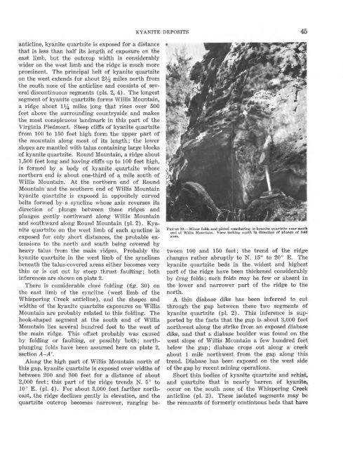
There is considerable close folding (fig. 30) on<br />
<strong>the</strong> east limb <strong>of</strong> <strong>the</strong> syncline (west limb <strong>of</strong> <strong>the</strong><br />
Whispering Creek anticline), <strong>and</strong> <strong>the</strong> shapes <strong>and</strong><br />
widths <strong>of</strong> <strong>the</strong> kyanite quartzite exposures on Willis<br />
Mountain are probably related to this folding. The<br />
hook-shaped segment at <strong>the</strong> south end <strong>of</strong> Willis<br />
Mountain lies several hundred feet to <strong>the</strong> west <strong>of</strong><br />
<strong>the</strong> main ridge. This <strong>of</strong>fset probably was caused<br />
by folding or faulting, or possibly both; northplunging<br />
folds have been assumed here on plate 2,<br />
section A-A'.<br />
Along <strong>the</strong> high part <strong>of</strong> Willis Mountain north <strong>of</strong><br />
this gap, kyanite quartzite is exposed over widths <strong>of</strong><br />
between 200 <strong>and</strong> 300 feet for a distance <strong>of</strong> about<br />
2,000 feet; this part <strong>of</strong> <strong>the</strong> ridge trends N. 5° to<br />
10° E. (pi. 4). For about 3,000 feet far<strong>the</strong>r nor<strong>the</strong>ast,<br />
<strong>the</strong> ridge declines gently in elevation, <strong>and</strong> <strong>the</strong><br />
quartzite outcrop becomes narrower, ranging be-<br />
FIGURE 30. Minor folds <strong>and</strong> pitted wea<strong>the</strong>ring in kyanite quartzite near south<br />
end <strong>of</strong> Willis Mountain. View looking north in direction <strong>of</strong> plunge <strong>of</strong> fold<br />
axes.<br />
tween 100 <strong>and</strong> 150 feet; <strong>the</strong> trend <strong>of</strong> <strong>the</strong> ridge<br />
changes ra<strong>the</strong>r abruptly to N. 15° to 20° E. The<br />
kyanite quartzite beds in <strong>the</strong> widest <strong>and</strong> highest<br />
part <strong>of</strong> <strong>the</strong> ridge have been thickened considerably<br />
by drag folds; such folds may be few or absent in<br />
<strong>the</strong> lower <strong>and</strong> narrower part <strong>of</strong> <strong>the</strong> ridge to <strong>the</strong><br />
north.<br />
A thin diabase dike has been inferred to cut<br />
through <strong>the</strong> gap between <strong>the</strong>se two segments <strong>of</strong><br />
kyanite quartzite (pi. 2). This inference is supported<br />
by <strong>the</strong> facts that <strong>the</strong> gap is about 3,000 feet<br />
northwest along <strong>the</strong> strike from an exposed diabase<br />
dike, <strong>and</strong> that a diabase boulder was found on <strong>the</strong><br />
west slope <strong>of</strong> Willis Mountain a few hundred feet<br />
below <strong>the</strong> gap; diabase crops out along a creek<br />
about 1 mile northwest from <strong>the</strong> gap along this<br />
trend. Diabase has been exposed on <strong>the</strong> west side<br />
<strong>of</strong> <strong>the</strong> gap by recent mining operations.<br />
Short thin bodies <strong>of</strong> kyanite quartzite <strong>and</strong> schist,<br />
<strong>and</strong> quartzite that is nearly barren <strong>of</strong> kyanite,<br />
occur on <strong>the</strong> south nose <strong>of</strong> <strong>the</strong> Whispering Creek<br />
anticline (pi. 2). These isolated segments may be<br />
<strong>the</strong> remnants <strong>of</strong> formerly continuous beds that have


