Bulletin of the Geological Society of Denmark, Vol. 27/01-02, pp. 15-45
Bulletin of the Geological Society of Denmark, Vol. 27/01-02, pp. 15-45
Bulletin of the Geological Society of Denmark, Vol. 27/01-02, pp. 15-45

Create successful ePaper yourself
Turn your PDF publications into a flip-book with our unique Google optimized e-Paper software.
42 Nielsen & Nielsen: Nearshore sediments in non-tidal environment<br />
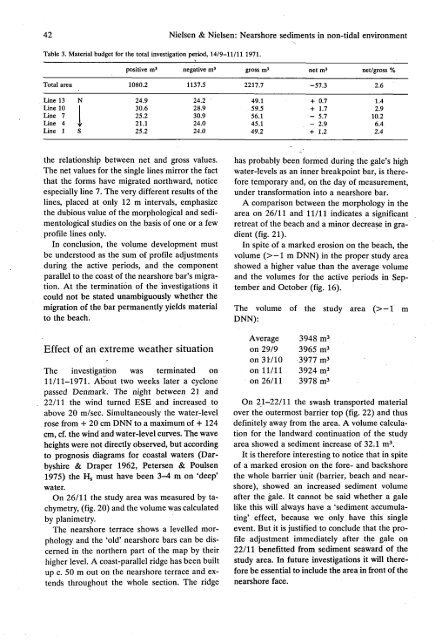
Table 3. Material budget for <strong>the</strong> total investigation period, 14/9-11/11 1971.<br />
positive m 3 negative m 3 gross m 3<br />
Total area 1080.2 1137.5 2217.7<br />
net m 3<br />
-57.3<br />
net/gross %<br />
2.6<br />
Line 13<br />
Line 10<br />
Line 7<br />
Line 4<br />
Line 1<br />
24.9<br />
30.6<br />
25.2<br />
21.1<br />
25.2<br />
24.2<br />
28.9<br />
30.9<br />
24.0<br />
24.0<br />
49.1<br />
59.5<br />
56.1<br />
<strong>45</strong>.1<br />
49.2<br />
+ 0.7<br />
+ 1.7<br />
- 5.7<br />
- 2.9<br />
+ 1.2<br />
1.4<br />
2.9<br />
10.2<br />
6.4<br />
2.4<br />
<strong>the</strong> relationship between net and gross values.<br />
The net values for <strong>the</strong> single lines mirror <strong>the</strong> fact<br />
that <strong>the</strong> forms have migrated northward, notice<br />
especially line 7. The very different results <strong>of</strong> <strong>the</strong><br />
lines, placed at only 12 m intervals, emphasize<br />
<strong>the</strong> dubious value <strong>of</strong> <strong>the</strong> morphological and sedimentological<br />
studies on <strong>the</strong> basis <strong>of</strong> one or a few<br />
pr<strong>of</strong>ile lines only.<br />
In conclusion, <strong>the</strong> volume development must<br />
be understood as <strong>the</strong> sum <strong>of</strong> pr<strong>of</strong>ile adjustments<br />
during <strong>the</strong> active periods, and <strong>the</strong> component<br />
parallel to <strong>the</strong> coast <strong>of</strong> <strong>the</strong> nearshore bar's migration.<br />
At <strong>the</strong> termination <strong>of</strong> <strong>the</strong> investigations it<br />
could not be stated unambiguously whe<strong>the</strong>r <strong>the</strong><br />
migration <strong>of</strong> <strong>the</strong> bar permanently yields material<br />
to <strong>the</strong> beach.<br />
Effect <strong>of</strong> an extreme wea<strong>the</strong>r situation<br />
The investigation was terminated on<br />
11/11-1971. About two weeks later a cyclone<br />
passed <strong>Denmark</strong>. The night between 21 and<br />
22/11 <strong>the</strong> wind turned ESE and increased to<br />
above 20 m/sec. Simultaneously <strong>the</strong> water-level<br />
rose from + 20 cm DNN to a maximum <strong>of</strong> + 124<br />
cm, cf. <strong>the</strong> wind and water-level curves. The wave<br />
heights were not directly observed, but according<br />
to prognosis diagrams for coastal waters (Darbyshire<br />
& Draper 1962, Petersen & Poulsen<br />
1975) <strong>the</strong> H s must have been 3-4 m on 'deep'<br />
water.<br />
On 26/11 <strong>the</strong> study area was measured by tachymetry,<br />
(fig. 20) and <strong>the</strong> volume was calculated<br />
by planimetry.<br />
The nearshore terrace shows a levelled morphology<br />
and <strong>the</strong> 'old' nearshore bars can be discerned<br />
in <strong>the</strong> nor<strong>the</strong>rn part <strong>of</strong> <strong>the</strong> map by <strong>the</strong>ir<br />
higher level. A coast-parallel ridge has been built<br />
up c. 50 m out on <strong>the</strong> nearshore terrace and extends<br />
throughout <strong>the</strong> whole section. The ridge<br />
has probably been formed during <strong>the</strong> gale's high<br />
water-levels as an inner breakpoint bar, is <strong>the</strong>refore<br />
temporary and, on <strong>the</strong> day <strong>of</strong> measurement,<br />
under transformation into a nearshore bar.<br />
A comparison between <strong>the</strong> morphology in <strong>the</strong><br />
area on 26/11 and 11/11 indicates a significant<br />
retreat <strong>of</strong> <strong>the</strong> beach and a minor decrease in gradient<br />
(fig. 21).<br />
In spite <strong>of</strong> a marked erosion on <strong>the</strong> beach, <strong>the</strong><br />
volume (>—1 m DNN) in <strong>the</strong> proper study area<br />
showed a higher value than <strong>the</strong> average volume<br />
and <strong>the</strong> volumes for <strong>the</strong> active periods in September<br />
and October (fig. 16).<br />
The volume <strong>of</strong> <strong>the</strong> study area (>-l<br />
DNN):<br />
Average<br />
on 29/9<br />
on 31710<br />
on 11/11<br />
on 26/11<br />
3948 m 3<br />
3965 m 3<br />
3977 m 3<br />
3924 m 3<br />
3978 m 3<br />
On 21-22/11 <strong>the</strong> swash transported material<br />
over <strong>the</strong> outermost barrier top (fig. 22) and thus<br />
definitely away from <strong>the</strong> area. A volume calculation<br />
for <strong>the</strong> landward continuation <strong>of</strong> <strong>the</strong> study<br />
area showed a sediment increase <strong>of</strong> 32.1 m 3 .<br />
It is <strong>the</strong>refore interesting to notice that in spite<br />
<strong>of</strong> a marked erosion on <strong>the</strong> fore- and backshore<br />
<strong>the</strong> whole barrier unit (barrier, beach and nearshore),<br />
showed an increased sediment volume<br />
after <strong>the</strong> gale. It cannot be said whe<strong>the</strong>r a gale<br />
like this will always have a 'sediment accumulating'<br />
effect, because we only have this single<br />
event. But it is justified to conclude that <strong>the</strong> pr<strong>of</strong>ile<br />
adjustment immediately after <strong>the</strong> gale on<br />
22/11 benefitted from sediment seaward <strong>of</strong> <strong>the</strong><br />
study area. In future investigations it will <strong>the</strong>refore<br />
be essential to include <strong>the</strong> area in front <strong>of</strong> <strong>the</strong><br />
nearshore face.<br />
m